Threats of Ionosphere on GNSS an general overview of CIGALA and CALIBRA Projects
|
|
|
- Shanon Hopkins
- 8 years ago
- Views:
Transcription

1 Threats of Ionosphere on GNSS an general overview of CIGALA and CALIBRA Projects João Francisco Galera Monico Vinícius Stuani
2 Presentation Outline Threats of Ionosphere on GNSS o Ionosphere effects and scintillation CIGALA & CALIBRA Projects o The team, objectives and realizations o Network Preliminary results & comments
3 Threats of Ionosphere on GNSS Ionosphere is the main source of errors for GNSS single frequency users; For GNSS dual frequency users, the first order effects are eliminated; 2 nd order can me modeled (Marques, Monico & Aquino (2011) GPS Solution); For GNSS single frequency users, a model my be used (Ionex files from several agencies, Klobuchar or NeQuick models, and others) Image from ISS
4 Threats of Ionosphere on GNSS Effects such as ionospheric scintillations, caused by time-varying electron density irregularities in the ionosphere that occur more often at equatorial and high latitudes regions, in particular during solar maxima, may cause problems such as: signal power fading, phase cycle slips, receiver loss of lock, etc., Such effects degrade the position quality provided by the satellite navigation systems (GNSS). This problem is still to be solved! Image from ISS
5 Ionospheric Scintillation Ionospheric scintillation (IS) is caused by time-varying electron density irregularities in the ionosphere that occur more often at equatorial and high latitudes and during solar maximum IS may degrade the quality of GNSS positioning and navigation
6 Ionospheric Scintillation The reliance on GNSS, especially by countries with large territorial coverage, has increased, and IS may be a potential problem for reaching the predicted annual global market for GNSS of about 300bn by 2020

7 Impact of IS on GNSS Threats from Ionospheric Scintillation GNSS Satellite Safety-critical applications Plasma perturbations TEC Ionosphere v impact signal fluctuations GNSS Receiver Precise positioning 8
8 Latin America GNSS Demands Off-shore Precision Agriculture High Accuracy Positioning Aerial Navigation Rural Cadastre (Brazil accuracy better than 50 cm 1 sigma)
9 Precise Agriculture demands 24h of RTK Service Mendonça; Monico; Motoki (2012)
10 Degradation in the Absolute Positioning Silva; Monico; Marques (2012)
11 The Threat to GNSS Current strong reliance on GNSS signals and receivers o Solar maximum was expected pose serious threats to GPS o Signals may be corrupted o Services may have outages o How will Galileo signals be affected? Modeling ionospheric scintillation essential to develop countermeasures GPS scintillation event associated with sudden TEC changes (Brazilian receiver)

12 CIGALA and CALIBRA Projects
13 CIGALA CIGALA (Concept for Ionospheric Scintillation Mitigation for Professional GNSS in Latin America) o Funded by European Commission (EC) in the framework of the FP7-GALILEO-2009-GSA (European GNSS Agency) o The aims were to analyze the ionospheric scintillation effects, to know its causes and to develop new approaches to be developed in multi-frequency GNSS receivers

14 CIGALA Partners
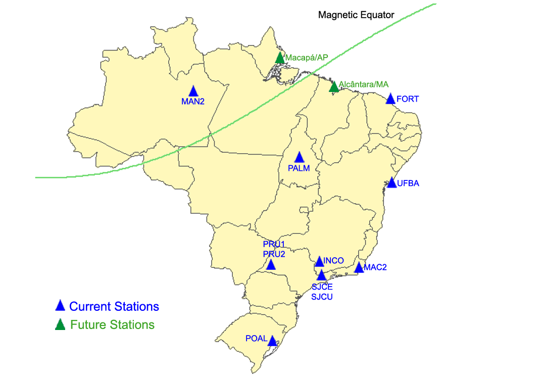
15 CIGALA CIGALA Project was finalized on February 2012 (two year of duration) But the GNSS network composed of 8 GNSS IS monitoring stations continued collecting data It consists of a very useful database for monitoring the ionosphere in Brazil
16 CIGALA Network
17 CALIBRA Following CIGALA, the CALIBRA project was approved CALIBRA (Countering GNSS high Accuracy applications Limitations due to Ionospheric disturbances in BRAzil) KoM was on November 2012 and will end on February 2015.
18 CALIBRA It was also funded by the European Commission in the framework of the FP7-GALILEO-2011-GSA activity It aims to develop new algorithms (and improve existing ones) that can be applied to high accuracy GNSS techniques in order to tackle the effects of ionospheric disturbances o Mainly on PPP and RTK
19 CALIBRA Partners
20 CIGALA vs CALIBRA Market needs & user requirements Underlying causes of scintillation and new models for signal propagation and tracking perturbations Deployment of specialised network of multi GNSS ionospheric monitoring receivers Use of simulated data to complement new measurements Mitigation at tracking level Field testing new countermeasures Review business case for high accuracy applications Ionospheric phenomena affecting high accuracy positioning in particular Exploitation & extension + micro test area in the state of São Paulo Use of historical data including URTKN data Mitigation at positioning level Field testing at application level
21 Main Objectives / Review Identify and describe vulnerabilities of GNSS carrier phase based techniques and reliant services/applications to ionospheric disturbances Establish metric and characterise ionosphere related effects degrading applications RTK, NRTK and PPP in particular o In terms of accuracy, integrity and availability Develop local empirical models for TEC climatology and scintillation
22 Main Objectives / Review Develop new algorithms for cleaner observable to enable improved positioning performance Implement algorithms on SSN receivers Carry out application specific field tests, e.g. static, dynamic, offshore, etc. Validate and fine tune algorithms
23 Method CSG CSG
24 Organizational Chart CALIBRA WP100 Problem Characterisation WP200 Geophysics and modelling. WP3 Algorithm development. WP4 Algorithm implementation WP5 Testing and validation. WP6 Dissemination and awareness WP7 Management Dissemination of results and awareness to the project and its impact on the attractiveness of Galileo for the user community in Brazil and consequently in Latin America
25 CIGALA/CALIBRA Network
26 CIGALA/CALIBRA Partners in Brazil


27 CIGALA/CALIBRA Partners in Brazil
28 CALIBRA Micro Test Area To allow the experimental evaluation of the plasma drift velocity under scintillation scenario by applying algorithm such as cross-correlation function of the GNSS signal amplitudes using 50Hz data.
29 GNSS-SP Network - URTKN
30 UNESP RTK Test Area Track 1 Partial Obstruction Track 2 Several Obstructions Track 3 No Obstruction Track 4 & 6 Partial Obstruction & Multipath Track 5 & 7 Multipath
31 High accuracy leveling UNESP RTK Test Area
32 UNESP RTK Test Area High accuracy GNSS and Total Station Positioning
33 Preliminary Results The deployed CIGALA/CALIBRA Network ISMR Query and Visualization Tool for parameters like S4, SigmaPhi, LockTime and so on, with more than two years of data High accuracy GNSS market surveying Ionospheric short term empirical forecasting model Ionospheric model with gradients A filtering method developed to improve GNSS receiver data quality
34 Preliminary Results Receivers with capability of working under moderate to strong scintillation Algorithm for IS mitigation on RTK and PPP Data from several field tests Data from the Micro Test Area Data from PA tests on dynamic environment UNESP RTK Test area for IS and ordinary surveying tests And much more
35 Questions? (Perguntas?...)
A filtering method developed to improve GNSS receiver data quality in the CALIBRA project
 A filtering method developed to improve GNSS receiver data quality in the CALIBRA project Luca Spogli 1, Vincenzo Romano 1,2, Giorgiana De Franceschi 1, Lucilla Alfonsi 1, Eleftherios Plakidis 1, Claudio
Lucilla Alfonsi. Giorgiana De Franceschi, Vincenzo Romano, Luca Spogli-INGV In collaboration with Anita Aikio-University of Oulu
 Lucilla Alfonsi Giorgiana De Franceschi, Vincenzo Romano, Luca Spogli-INGV In collaboration with Anita Aikio-University of Oulu EISCAT _3D User Meeting 2012 Introduction Ionospheric scintillation GNSS
A Statistical Analysis of GPS L1, L2, and L5 Tracking Performance During Ionospheric Scintillation
 A Statistical Analysis of GPS L1, L2, and L5 Tracking Performance During Ionospheric Scintillation Susan H. Delay, Charles S. Carrano, Keith M. Groves, Patricia H. Doherty Institute for Scientific Research,
The Effect of Space Weather Phenomena on Precise GNSS Applications
 FUGRO SATELLITE POSITIONING Doc. Ref.: A12321850TCBRC1 The Effect of Space Weather Phenomena on Precise GNSS Applications December 2014 PUBLIC Table of contents The Effect of Space Weather Phenomena on
Post Processing Service
 Post Processing Service The delay of propagation of the signal due to the ionosphere is the main source of generation of positioning errors. This problem can be bypassed using a dual-frequency receivers
Enabling RTK-like positioning offshore using the global VERIPOS GNSS network. Pieter Toor GNSS Technology Manager
 Enabling RTK-like positioning offshore using the global VERIPOS GNSS network Pieter Toor GNSS Technology Manager Introduction PPP/RTK Positioning Techniques PPP-AR Technology Presentation Overview PPP-AR
CHARACTERISTICS OF DEEP GPS SIGNAL FADING DUE TO IONOSPHERIC SCINTILLATION FOR AVIATION RECEIVER DESIGN
 CHARACTERISTICS OF DEEP GPS SIGNAL FADING DUE TO IONOSPHERIC SCINTILLATION FOR AVIATION RECEIVER DESIGN Jiwon Seo, Todd Walter, Tsung-Yu Chiou, and Per Enge Stanford University ABSTRACT Aircraft navigation
Prof. Ludovico Biagi. Satellite Navigation and Monitoring
 Prof. Ludovico Biagi Satellite Navigation and Monitoring Navigation: trajectories control positions estimations in real time, at high frequency popular applications: low accuracy (10 m) required specific
BRAZILIAN CONTRIBUTION TO THE LISN PROJECT
 BRAZILIAN CONTRIBUTION TO THE LISN PROJECT (LOW-LATITUDE IONOSPHERIC SENSOR NETWORK) I. J. Kantor, E.R de Paula, L.F.C. de Rezende, M.T.H. Muella and A.C. Neto INPE, Aeronomy Division, São José dos Campos,
A study of long-term climatology of ionospheric irregularities by using GPS phase fluctuations at the Brazilian longitudes
 Advances in Space Research xxx (2007) xxx xxx www.elsevier.com/locate/asr A study of long-term climatology of ionospheric irregularities by using GPS phase fluctuations at the Brazilian longitudes F.D.
RBMC: The main geodetic infrastructure contributing for land reform and weather researches in Brazil
 RBMC: The main geodetic infrastructure contributing for land reform and weather researches in Brazil Sonia Costa - IBGE Hisao Takahashi and Luiz Sapucci - INPE Workshop on the Applications of Global Navigation
Trimble CenterPoint RTX Post-Processing Services FAQs
 Trimble CenterPoint RTX Post-Processing Services FAQs What is Trimble RTX technology? 30 September 2013 Trimble RTX TM (Real Time extended) is a high-accuracy, global GNSS correction technology that combines
and Navigation Systems
 Global Ionospheric Monitoring and Navigation Systems J. Feltens, M. Angling, N. Jakowski, M. Hernández-Pajares, R. Zandbergen 1 Consortium Partners Hewlett-Packard GmbH, Rüsselsheim, Germany QinetiQ Ltd,
a Brief Background DEFINITION
 GNSS FOR AVIATION a Brief Background ANC informal briefing DEFINITION GNSS: A worldwide position and time determination ti system that t includes one or more satellite constellations, aircraft receivers
Local monitoring by low cost devices and free and open sources softwares
 Local monitoring by low cost devices and free and open sources softwares Abstract Ludovico Biagi, Florin-Catalin Grec, Marco Negretti, Maria Grazia Visconti Politecnico di Milano, DICA@ComoCampus The purpose
Development of GBAS Ionosphere Anomaly Monitor Standards to Support Category III Operations
 Development of GBAS Ionosphere Anomaly Monitor Standards to Support Category III Operations Matt Harris, Tim Murphy, Susumu Saito Presentation for ENRI International Workshop on ATM / CNS Tokyo, Japan
Günter Seeber. Satellite Geodesy 2nd completely revised and extended edition
 Günter Seeber Satellite Geodesy 2nd completely revised and extended edition Walter de Gruyter Berlin New York 2003 Contents Preface Abbreviations vii xvii 1 Introduction 1 1.1 Subject of Satellite Geodesy...
SPACE WEATHER SUPPORT FOR COMMUNICATIONS. Overview
 SPACE WEATHER SUPPORT FOR COMMUNICATIONS Overview Ionospheric variability (space weather) significantly impacts ground and space-based communications. In essence, the electrically charged particles of
Progress on Space Weather Products and Services for the GPS/GNSS Community.
 Progress on Space Weather Products and Services for the GPS/GNSS Community. Rob Steenburgh Space Scientist w/thanks to Rodney Viereck, Chris Balch, and Howard Singer Space Weather Prediction Center National
The Applanix SmartBase TM Software for Improved Robustness, Accuracy, and Productivity of Mobile Mapping and Positioning
 The Applanix SmartBase TM Software for Improved Robustness, Accuracy, and Productivity of Mobile Mapping and Positioning Joe Hutton and Edith Roy, Applanix Corporation Introduction Applanix, along with
A Beginner s Guide to Space Weather and GPS Professor Paul M. Kintner, Jr. with acknowledgements to
 A Beginner s Guide to Space Weather and GPS Professor Paul M. Kintner, Jr. with acknowledgements to M. Psiaki, T. Humphreys, A. Cerruti, B. Ledvina, A. Mannucci, and E. R. de Paula I. Introduction This
Space Environment and Satellite Systems: Removing Clutter from Ground-to-Satellite Signals. Sigrid Close
 Space Environment and Satellite Systems: Removing Clutter from Ground-to-Satellite Signals Sigrid Close Background Overview RF propagation through ionosphere can be problematic Goals Traditionally too
The European GNSS Programmes EGNOS and Galileo
 The European GNSS Programmes EGNOS and Galileo 6th ICG Conference Pieter De Smet European Commission 5 September 2011 1. State of Play of EGNOS 2. State of Play of Galileo 5 September, 2011 The European
GENERAL INFORMATION ON GNSS AUGMENTATION SYSTEMS
 GENERAL INFORMATION ON GNSS AUGMENTATION SYSTEMS 1. INTRODUCTION Navigation technologies with precision approach and landing systems, for civilian and military purposes, enable aircrafts to perform their
Global Positioning System
 B. Hofmann-Wellenhof, H. Lichtenegger, and J. Collins Global Positioning System Theory and Practice Third, revised edition Springer-Verlag Wien New York Contents Abbreviations Numerical constants xix xxiii
A totally SDR-based Low Cost Augmentation System for Institutional Applications
 A totally SDR-based Low Cost Augmentation System for Institutional Applications R. Capua, L. Gattuso, A. Caporale, M. Giangolini, F. Frittella, C. D Amico, D. Tufillaro 21 January 2016 R. Capua DO-11-DO-01
Satellite Posi+oning. Lecture 5: Satellite Orbits. Jan Johansson jan.johansson@chalmers.se Chalmers University of Technology, 2013
 Lecture 5: Satellite Orbits Jan Johansson jan.johansson@chalmers.se Chalmers University of Technology, 2013 Geometry Satellite Plasma Posi+oning physics Antenna theory Geophysics Time and Frequency GNSS
Apogee Series. > > Motion Compensation and Data Georeferencing. > > Smooth Workflow. Mobile Mapping. > > Precise Trajectory and Direct Georeferencing
 Ultimate accuracy MEMS Apogee Series Inertial Navigation System Motion Sensing and Georeferencing > INS > MRU > AHRS ITAR free 0,005 RMS Apogee Series High quality, high accuracy Hydrography > > Motion
GNSS integrity monitoring for the detection and mitigation of interference
 GNSS integrity monitoring for the detection and mitigation of interference Dr. Shaojun Feng Centre for Transport Studies Outline GNSS vulnerability GNSS integrity monitoring Cases study GAARDIAN ERAIM
European GNSS Applications in Horizon 2020
 European GNSS Applications in Horizon 2020 Official International Space Information Day 2015, Brussels 10 November 2015 Marta Krywanis-Brzostowska European GNSS Agency Integrated approach: understanding
GNSS and Heighting, Practical Considerations. A Parker National Geo-spatial Information Department of Rural Development and Land Reform
 GNSS and Heighting, Practical Considerations A Parker National Geo-spatial Information Department of Rural Development and Land Reform GNSS Global Navigation Satellite Systems (GNSS) Global Positioning
INTEGRITY AND CONTINUITY ANALYSIS OCTOBER TO DECEMBER 2013 QUARTERLY REPORT FROM GPS. Integrity and Continuity Analysis 08/01/14 08/01/14 08/01/14
 INTEGRITY AND CONTINUITY ANALYSIS FROM GPS OCTOBER TO DECEMBER 2013 QUARTERLY REPORT Prepared by: M Pattinson (NSL) 08/01/14 Checked by: L Banfield (NSL) 08/01/14 Approved by: M Dumville (NSL) 08/01/14
EUTERPE - EUROPEAN TEST CENTRE FOR RECEIVER PERFORMANCE EVALUATION
 ABSTRACT EUTERPE - EUROPEAN TEST CENTRE FOR RECEIVER PERFORMANCE EVALUATION David Jiménez-Baños (1), Michel Tossaint (1), Jean-Luc Gerner (1), Rafael Lucas-Rodríguez (2) (1) Radio Navigation Systems and
Waypoint. Best-in-Class GNSS and GNSS+INS Processing Software
 Waypoint Best-in-Class GNSS and GNSS+INS Processing Software Waypoint Exceptional Post-Processing Software Enhance your GNSS Position, Velocity and Attitude Accuracy For applications requiring highly
Antennas & Propagation. CS 6710 Spring 2010 Rajmohan Rajaraman
 Antennas & Propagation CS 6710 Spring 2010 Rajmohan Rajaraman Introduction An antenna is an electrical conductor or system of conductors o Transmission - radiates electromagnetic energy into space o Reception
Zuverlässige Navigation für die Luftfahrt. Boubeker Belabbas Institute of Communications and Navigation
 www.dlr.de Chart 1 TU Graz > 5. Navigations-Get-Together > Boubeker Belabbas > 9.10.2012 Zuverlässige Navigation für die Luftfahrt Boubeker Belabbas Institute of Communications and Navigation www.dlr.de
Space Weather: An Introduction C. L. Waters. Centre for Space Physics University of Newcastle, Australia
 Space Weather: An Introduction C. L. Waters Centre for Space Physics University of Newcastle, Australia 1 Outline Space weather: Conditions on the Sun and in the solar wind, magnetosphere, ionosphere and
International Global Navigation Satellite Systems Service
 International Global Navigation Satellite Systems Service IGS Multi-GNSS Experiment IGS M-GEX Call for Participation www.igs.org Response to this Call for Participation in IGS M-GEX via Web Form Submission
Leica SmartNet UK & Ireland Network RTK User Guide
 Leica SmartNet UK & Ireland Network RTK User Guide Contents Background.. Page 3 Single Base RTK.... Page 3 Advantages & Disadvantages of Single Base RTK Page 4 Network RTK... Page 4 Advantages & Disadvantages
Biography. Key Words. Abstract. Table of Contents. 1. Introduction. Spectrum management, GPS interference, jamming
 Crowded streets of spectrum is GPS being walked all over? Greg Gerten Analytical Graphics, Inc. 220 Valley Creek Blvd. Exton, PA 19341 610.981.8224 ggerten@agi.com Biography Greg Gerten is the navigation
Workshop Settimo Programma Quadro Galileo
 Innovative LBS for Social/Public Dimension Workshop Settimo Programma Quadro Galileo 26 giugno 2012 Navigation and Integrated Communication BU What is INCLUSION? A project co-funded by the European GNSS
Scintillation Characteristics across the GPS Frequency Band
 Scintillation Characteristics across the GPS Frequency Band Charles S. Carrano, Keith M. Groves, William J. McNeil, and Patricia H. Doherty Institute for Scientific Research, Boston College, Boston, MA
Agenda. Agilent GPS Receiver Test Solutions. GPS technology concepts. Basic tests required for GPS receiver verification Test solutions
 Agenda GPS technology concepts GPS and GNSS overview Assisted GPS (A-GPS) Basic tests required for GPS receiver verification Test solutions Signal creation for GPS receiver test A-GPS test systems Agilent
MULTI-GNSS DEMONTRATION CAMPAIGN IN ASIA OCEANIA REGION
 UNITED NATIONS INTERNATIONAL MEETING ON THE APPLICATIONS OF GLOBAL NAVIGATION SATELLITE SYSTEMS PRESENTATION SESSION 2: INTERNATIONAL INITIATIVES/EXPERIENCES MULTI-GNSS DEMONTRATION CAMPAIGN IN ASIA OCEANIA
GNSS MONITORING NETWORKS
 SPACE GNSS MONITORING NETWORKS Satellite communications, earth observation, navigation and positioning and control stations indracompany.com GNSS MONITORING NETWORKS GNSS MONITORING NETWORKS Indra s solutions
Introduction into Real-Time Network Adjustment with Geo++ GNSMART
 Introduction into Real-Time Network Adjustment with Geo++ GNSMART Andreas Bagge Gerhard Wübbena, Martin Schmitz Geo++ GmbH D-30827 Garbsen, Germany www.geopp.de GeoInformation Workshop 2004, Istanbul Kultur
Clocks/timers, Time, and GPS
 FYS3240 PC-based instrumentation and microcontrollers Clocks/timers, Time, and GPS Spring 2015 Lecture #11 Bekkeng, 22.12.2014 How good is a crystal oscillator (XO)? Interested in the long-term measurement
e-knot Professional Training Program
 e-knot Professional Training Program PRESENTATION OF THE E-KNOT PROJECT The e-knot project aims at building strong links between universities, research institutes and industry, and leveraging on past activities
IP-S2 HD. High Definition 3D Mobile Mapping System
 IP-S2 HD High Definition 3D Mobile Mapping System Integrated, turnkey solution High Density, Long Range LiDAR sensor for ultimate in visual detail High Accuracy IMU and DMI Odometry for positional accuracy
Rafael Lucas EUROPEAN SPACE AGENCY. Rafael.Lucas.Rodriguez@esa.int
 ESA Navigation Support Facilities Rafael Lucas EUROPEAN SPACE AGENCY Rafael.Lucas.Rodriguez@esa.int Background The ESA/ESTEC Radionavigation laboratory was created in 1989 to support the application of
Greg Keel P.Eng. Parallel Geo Services gkeel@nanaimo.ark.com
 Greg Keel P.Eng. Parallel Geo Services gkeel@nanaimo.ark.com Presentation Outline GNSS: Global Navigation Satellite System GPS: overview, current signals, modernization GLONASS: history (rise fall rise),
PART 5D TECHNICAL AND OPERATING CHARACTERISTICS OF MOBILE-SATELLITE SERVICES RECOMMENDATION ITU-R M.1188
 Rec. ITU-R M.1188 1 PART 5D TECHNICAL AND OPERATING CHARACTERISTICS OF MOBILE-SATELLITE SERVICES Rec. ITU-R M.1188 RECOMMENDATION ITU-R M.1188 IMPACT OF PROPAGATION ON THE DESIGN OF NON-GSO MOBILE-SATELLITE
Galileo Ready Advanced Mass Market Receiver (GRAMMAR) Project Workshop Outline
 Project Workshop Outline") DLR ACO TUT 2011 Project Overview ICL-GNSS, Tampere, Finland, June 29-30 2011 Page 1 30.06.2010 Galileo Ready Advanced Mass Market Receiver (GRAMMAR) Project Workshop Outline» Part I (9:45-11:00)» Overview
DLR ACO TUT 2011 Project Overview ICL-GNSS, Tampere, Finland, June 29-30 2011 Page 1 30.06.2010 Galileo Ready Advanced Mass Market Receiver (GRAMMAR) Project Workshop Outline» Part I (9:45-11:00)» Overview
How To Understand And Understand The Power Of A Cdma/Ds System
 CDMA Technology : Pr. Dr. W. Skupin www.htwg-konstanz.de Pr. S. Flament www.greyc.fr/user/99 On line Course on CDMA Technology CDMA Technology : Introduction to Spread Spectrum Technology CDMA / DS : Principle
EASA Safety Information Bulletin
 EASA Safety Information Bulletin SIB No.: 2012-09 Issued: 23 May 2012 Subject: Effects of Space Weather on Aviation Ref. Publication: 1. EU OPS 1.390 Cosmic Radiation; 2. SIB 2012-10 Single Event Effects
Permanent GNSS station network and AlpCheck: freight transport monitoring
 Permanent GNSS station network and AlpCheck: freight transport monitoring 19 th June 2008 Giorgio Gaber Auditorium Palazzo della Regione Lombardia MILAN Francesco Matonti IREALP Project summary Problems
PLM PRODUCT INFORMATION
 PLM PRODUCT INFORMATION Agricultural Equipment UK & ROI Precision Farming Reference UK- PLM_03_13 Date: 1st May 2013 Announcing the new RangePoint RTX Correction Service RangePoint RTX is a GPS and GLONASS
Propsim enabled Aerospace, Satellite and Airborne Radio System Testing
 www.anite.com Propsim enabled Aerospace, Satellite and Airborne Radio System Testing Anite is now part of Keysight Technologies Realistic and repeatable real-time radio channel emulation solutions for
Swedish User Guidelines for Network RTK
 Swedish User Guidelines for Network RTK Robert Odolinski GNSS Research Centre, Curtin University of Technology (Previously Geodetic Research Department of Lantmäteriet, Sweden) Perth, WA, Australia robert.odolinski@curtin.edu.au
SURVEYING WITH GPS. GPS has become a standard surveying technique in most surveying practices
 SURVEYING WITH GPS Key Words: Static, Fast-static, Kinematic, Pseudo- Kinematic, Real-time kinematic, Receiver Initialization, On The Fly (OTF), Baselines, Redundant baselines, Base Receiver, Rover GPS
UCGE Reports Number 20214
 UCGE Reports Number 224 Department of Geomatics Engineering Performance Evaluation of Multiple Reference Station GPS RTK for a Medium Scale Network (URL: http://www.geomatics.ucalgary.ca/links/gradtheses.html)
Monitoring and Early Management of Emergences: New Instruments
 Monitoring and Early Management of Emergences: New Instruments Daniele Caviglia, DITEN - University of Genoa Domenico Sguerso, DICCA - University of Genoa Bianca Federici, DICCA - University of Genoa Andrea
Alberding GNSS data management & monitoring tools
 Alberding GNSS data management & monitoring tools 1/24 Alberding GNSS data management & monitoring tools Tamás Horváth Alberding GmbH EUREF 2013 Symposium, 29-31 May 2013, Budapest, Hungary Alberding GNSS
Development of BeiDou Navigation Satellite System
 The 7th Meeting of International Committee on GNSS Development of BeiDou Navigation Satellite System China Satellite Navigation Office November 5, 2012 Beijing, China Part Ⅰ Development Plan Part Ⅱ System
Presentation Outline. The NavSAS group; Examples of Software-Radio Technology in GNSS;
 Telemobility 2008 Progetto Galileo ed altri GNSS Development of GPS-Galileo Galileo Software Radio Receivers Marco Pini - NavSAS group Presentation Outline The NavSAS group; Basic on Software-Radio Technology;
International time scales Atomic standards
 International time scales Atomic standards E.F. Arias International Committee for GNSS, 2 nd Meeting Meeting of GNSS experts Bangalore, 5 September 2007 OUTLINE International coordination for metrology;
CORS/OPUS: Status & Future Prospects
 CORS/OPUS: Status & Future Prospects Richard Snay, Gerald Mader, & Neil Weston NOAA s National Geodetic Survey CORS Users Forum 44 th CGSIC Meeting Long Beach, CA September 21, 2004 Continuously Operating
European Position Determination System. Guidelines For Cross- Border Data Exchange
 European Position Determination System Guidelines For Cross- Border Data Exchange Version 1.0 21 September 2006 Copyright: Publisher: 2007 by the International EUPOS Steering Committee Office of the International
Dancing in the Dark: How GNSS Satellites Cross the Earth s Shadow
 Dancing in the Dark: How GNSS Satellites Cross the Earth s Shadow F. Dilssner, T. Springer, G. Gienger, R. Zandbergen European Space Operations Centre (ESOC), Darmstadt 24 January 2011 Technische Universität
Guidelines for RTK/RTN GNSS Surveying in Canada
 Guidelines for RTK/RTN GNSS Surveying in Canada July 2013 Version 1.1 Ministry of Transportation Ministère des Transports EARTH SCIENCES SECTOR GENERAL INFORMATION PRODUCT 100-E Main Authors: Brian Donahue,
Technologies for PRS Receivers
 Seventh Framework Programme of the European Community for Research, Technological Development and Demonstration Activities (2007 to 2013) 'Cooperation' Specific Programme Theme: Transport (including Aeronautics)
Ionospheric Research with the LOFAR Telescope
 Ionospheric Research with the LOFAR Telescope Leszek P. Błaszkiewicz Faculty of Mathematics and Computer Science, UWM Olsztyn LOFAR - The LOw Frequency ARray The LOFAR interferometer consist of a large
Alberding precision agriculture solutions
 Alberding precision agriculture solutions Alberding GmbH AGRITECHNICA 2015, 8 14 November 2015, Hanover, Germany Presentation by: Tamás Horváth & Katrin Arendholz Alberding GmbH - Precision agriculture
Leica AR25 White Paper
 Leica AR25 White Paper February 2009 Lennon Bedford, Neil Brown, Justin Walford Leica Geosystems AG Heerbrugg, Switzerland 2 Biography Lennon Bedford graduated from the University of Otago in 2003 with
European best practices in safe transport of dangerous material supported by GNSS
 2 nd GNSS Vulnerabilities and Solutions 2009 Conference, Baska, Croatia European best practices in safe transport of dangerous material supported by GNSS Gianmarco Baldini IPSC - JRC EC Antonella Di Fazio
Tracking IRNSS Satellites. for Multi-GNSS Positioning in Finland
 Tracking IRNSS Satellites for Multi-GNSS Positioning in Finland Figure 1. IRNSS Primary service area, satellite locations and relative position of Finland. Above, photo of IRNSS-1B satellite in clean room
INTRODUCTION TO GNSS NETWORK RTK. BAKU (AZERBAIDJAN) 12 Mai 2009. Ezzedine Djerbi Leica Geo-Systems Switzerland
 12 Mai 2009. Ezzedine Djerbi Leica Geo-Systems Switzerland") INTRODUCTION TO GNSS NETWORK RTK BAKU (AZERBAIDJAN) 12 Mai 2009 Ezzedine Djerbi Leica Geo-Systems Switzerland 1 GPS & GLONASS constellations have never been designed to serve the civilian applications
INTRODUCTION TO GNSS NETWORK RTK BAKU (AZERBAIDJAN) 12 Mai 2009 Ezzedine Djerbi Leica Geo-Systems Switzerland 1 GPS & GLONASS constellations have never been designed to serve the civilian applications
Motion Sensing without Sensors: Information. Harvesting from Signal Strength Measurements
 Motion Sensing without Sensors: Information Harvesting from Signal Strength Measurements D. Puccinelli and M. Haenggi Department of Electrical Engineering University of Notre Dame Notre Dame, Indiana,
Allen Goldstein NIST Synchrometrology Lab Gaithersburg, MD allen.goldstein@nist.gov
 Time Synchronization in Electrical Power Transmission and Distribution Systems Allen Goldstein NIST Synchrometrology Lab Gaithersburg, MD allen.goldstein@nist.gov Abstract Synchronization of measurements
Maritime Integrated PNT System
 Maritime Integrated PNT System Core element for safe ship navigation Evelin Engler und Thoralf Noack DLR Institut für Kommunikation und Navigation Folie 1 Maritime Integrated PNT System = overlay of satellite
Transforming Field Team Productivity in the Retail Market
 Transforming Field Team Productivity in the Retail Market We Work Where You Work The first step in transforming the productivity of any retail field team is to establish what success looks like, and ensure
The European Satellite Navigation Programmes EGNOS and Galileo
 The European Satellite Navigation Programmes EGNOS and Galileo Olivier Crop European GNSS Agency (GSA) Paris, 17 March 2014 20 March, 2014 The European GNSS Programmes 2 Basics of Satellite Navigation
GAL Project Galileo for Gravity
 GAL Project Galileo for Gravity Galileian Plus srl via Tiburtina 755 00159 Roma Angelo Amodio (aamodio@galileianplus.it) Collaborative Project Grant # 287193 GAL Project Call identifier: FP7-GALILEO-2011-GSA-1-a,
National Research Council White Paper CHU. Western Canada. Coverage Gap Elimination Proposal
 National Research Council White Paper CHU Western Canada Coverage Gap Elimination Proposal CHU CHU Time Station (Ottawa) is Canada's domestic shortwave time signal station. CHU existed long before the
DVB-SH. Radio Network Planning Tool. (Release 4.2)
") DVB-SH Radio Network Planning Tool (Release 4.2) by AWE Communications GmbH. All rights reserved 1 1 Introduction 1.1 Overview Digital Video Broadcasting Satellite to Handheld (DVB-SH) aims to provide
DVB-SH Radio Network Planning Tool (Release 4.2) by AWE Communications GmbH. All rights reserved 1 1 Introduction 1.1 Overview Digital Video Broadcasting Satellite to Handheld (DVB-SH) aims to provide
MSAS current status. Japan Civil Aviation Bureau S TSAT A ATELLITE-BASED S UGMENTATION. MTSAT Satellite-based Augmentation System
 MSAS current status Japan Civil Aviation Bureau Civil Aviation Bureau Ministry of Land, Infrastructure and Transport 1 Contents Overview of MSAS MSAS Status Process for MSAS Commissioning Results of OT&E
RAIM for Ship and Rig Management
 RAIM for Ship and Rig Management Maritime Applications Institute of Space Technology and Space Applications University FAF Munich, Germany PhD Student Diana Fontanella Diana.Fontanella@unibw.de PhD Student
Positioning (DiNO) DISTRIBUTION A. Approved for public release; distribution is unlimited
 DISTRIBUTION A. Approved for public release; distribution is unlimited") Distributed Network Opportunistic Positioning (DiNO) 2012 Joint Navigation Conference Session B7: Collaborative Navigation Techniques Dr. Alison K. Brown, Cayle Stickler, and Jarrett Redd NAVSYS Corporation
Distributed Network Opportunistic Positioning (DiNO) 2012 Joint Navigation Conference Session B7: Collaborative Navigation Techniques Dr. Alison K. Brown, Cayle Stickler, and Jarrett Redd NAVSYS Corporation
This is an author-deposited version published in : http://oatao.univ-toulouse.fr/ Eprints ID : 13072
 Open Archive TOULOUSE Archive Ouverte (OATAO) OATAO is an open access repository that collects the work of Toulouse researchers and makes it freely available over the web where possible. This is an author-deposited
GRAS. Första operationella instrumentet för temperaturmätning med GPS-signaler ger förbättrade väderprognoser och klimatmodeller.
 GRAS Första operationella instrumentet för temperaturmätning med GPS-signaler ger förbättrade väderprognoser och klimatmodeller. Magnus Bonnedal, RUAG Stefan Nilsson, SMHI RUAG Space AB 1 Radio Occultation
Checklist for Market Risk Management
 Checklist for Market Risk Management I. Development and Establishment of Market Risk Management System by Management Checkpoints - Market risk is the risk of loss resulting from changes in the value of
IP-S3 HD1. Compact, High-Density 3D Mobile Mapping System
 IP-S3 HD1 Compact, High-Density 3D Mobile Mapping System Integrated, turnkey solution Ultra-compact design Multiple lasers minimize scanning shades Unparalleled ease-of-use No user calibration required
Briefing Note: Evolution from Loran-C to eloran
 Briefing Note: Evolution from to Executive Summary This paper has been prepared by the Research and Radionavigation Directorate of the General Lighthouse Authorities of the United Kingdom and Ireland for
GPS Applications in Agriculture. Gary T. Roberson Agricultural Machinery Systems
 GPS Applications in Agriculture Gary T. Roberson Agricultural Machinery Systems What is a Positioning System? A position information system enables the user to determine absolute or relative location of
GEOGRAPHIC INFORMATION SYSTEMS Lecture 21: The Global Positioning System
 GEOGRAPHIC INFORMATION SYSTEMS Lecture 21: The Global Positioning System The Global Positioning System - recognize that GPS is only one of several Global Navigation Satellite Systems (GNSS) - the Russian
Propagation Channel Emulator ECP_V3
 Navigation simulators Propagation Channel Emulator ECP_V3 1 Product Description The ECP (Propagation Channel Emulator V3) synthesizes the principal phenomena of propagation occurring on RF signal links
IP-S2 Compact+ 3D Mobile Mapping System
 IP-S2 Compact+ 3D Mobile Mapping System 3D scanning of road and roadside features Delivers high density point clouds and 360 spherical imagery High accuracy IMU options without export control Simple Map,
Monitoring of Open Pit Mines using Combined GNSS Satellite Receivers and Robotic Total Stations
 Monitoring of Open Pit Mines using Combined GNSS Satellite Receivers and Robotic Total Stations N. Brown Leica Geosystems, Switzerland S. Kaloustian Leica Geosystems, Switzerland M. Roeckle Leica Geosystems,
Potential Effects of Wind Turbine Generators on Pre-Existing RF Communication Networks SEAN YUN. June 2009. Software Solutions in Radiocommunications
 Potential Effects of Wind Turbine Generators on Pre-Existing RF Communication Networks June 2009 SEAN YUN 2 2 Abstract In an effort to help preserve the ozone and the availability of diminishing natural
Perspective of Permanent Reference Network KOPOS in Kosova
 143 Perspective of Permanent Reference Network KOPOS in Kosova Meha, M. and Çaka, M. Kosovo Cadastral Agency, Kosovo Archive Building II nd floor, P.O. 10000, Prishtina, Republic of Kosovo, E-mail: mmeha@yahoo.com,