Topsectoren, de rol van big data en kansen vanuit het ruimtevaartonderzoek: Hoe satellietdata bijdragen aan duurzaamheid. Netherlands Space Office 1
|
|
|
- Lambert Lloyd
- 8 years ago
- Views:
Transcription
1 Topsectoren, de rol van big data en kansen vanuit het ruimtevaartonderzoek: Hoe satellietdata bijdragen aan duurzaamheid Netherlands Space Office 1

2 Netherlands Space Office Established in 2009 Space agency of the Netherlands government Reporting to: Task: > Ministry of Economic Affairs > Ministry of Education, Culture and Science > Ministry of Infrastructure and Environment > Netherlands Organisation for Scientific Research (NWO) Develop the Netherlands space policy and bring that into action Netherlands Space Office 2
 Develop the Netherlands space policy and bring that into action")
3 NSO: responsibilities and activities Represent Netherlands government to space agencies (ESA) and space industry National programmes, e.g.: - TROPOMI-instrument - Satellite Data Portal - Geodata for Agriculture & Water - ESA Business Incubation Centre Stimulate international cooperation with Dutch industry Invest in the future s space pioneers (students and young entrepreneurs) Netherlands Space Office 3

4 What? Clarify chemical processes in the Earth atmosphere How? UV/Vis and Infrared spectroscopy with space instruments like OMI, Sciamachy and Tropomi Who? Royal Meteorological Institute (KNMI), SRON, Dutch Space, TNO Netherlands Space Office 4
, SRON, Dutch Space,")
5 What? Tropospheric Monitoring Instrument (TROPOMI) To be launched on ESA s Sentinel-5-p in 2015 Monitoring air pollution on city level (7 x 7 km) How? Revolutionary design: immersed gratings Imaging spectrometer sensing CH4, NO2, SO2, Who? Netherlands Space Office 5

6 Netherlands Space Office 6
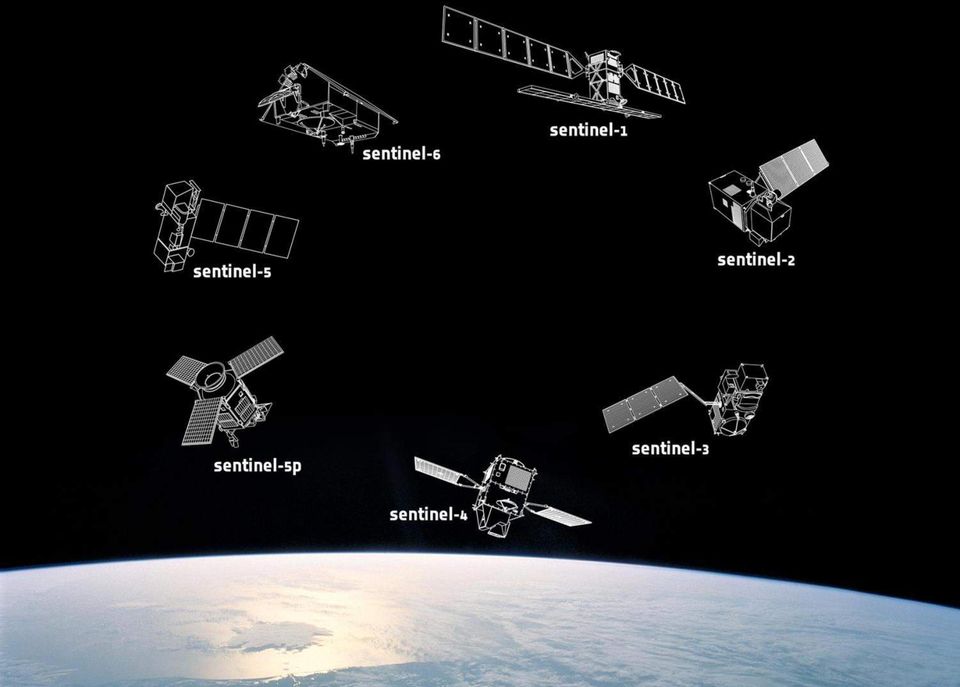
7 Sentinel-1 RADAR (land en mariene applicaties) Sentinel-2 Multispectraal (landapplicaties) 2015 Sentinel-3 Hyperspectraal (mariene applicaties) 2015 Sentinel-4 Multispectraal (atmosfeer, geostationaire baan) 2021 Sentinel-5P Multispectraal (atmosfeer, polaire baan) 2016 Sentinel-5 Multispectraal (atmosfeer, polaire baan) 2021 Sentinel-6 Altimetrie (mariene applicaties) 2020 Gratis en open data, gegarandeerde datastroom Netherlands Space Office 7
 2020 Gratis en open data, gegarandeerde datastroom Netherlands")
8 What? Miniaturised nano- and microsatellites How? Nano- and microsatellite platforms and launch services Formation Flying Miniaturised radar Miniaturised hyperspectral instruments Who? ISIS, Cosine, SSBV Netherlands Space Office 8

9 Netherlands Space Office 9

10 Netherlands Space Office 10 Netherlands Space Office

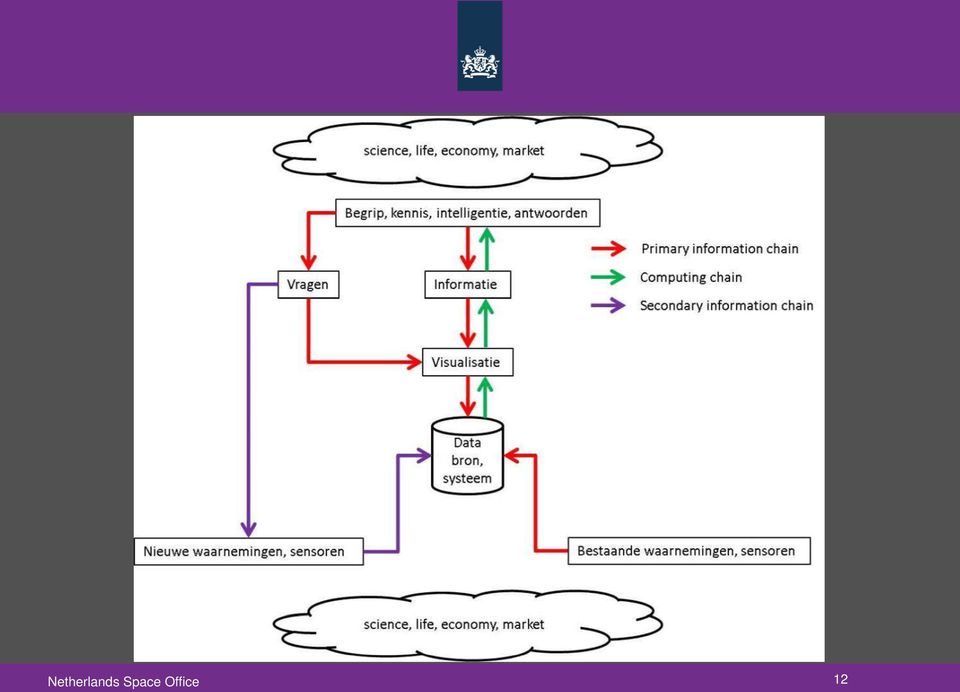
11 Big (Satellite) Data Huge amounts Heterogenous (Near) real-time Global sensing Local needs Integration with geo-information Serendipity Information value Netherlands Space Office 11

12 Netherlands Space Office 12
13 Netherlands Space Office 13
14 watertekort Optische beelden : 50 cm resolutie Netherlands Space Office 14 Netherlands Space Office

15 Panchromatisch Multi-spectraal Thermisch RADAR Netherlands Space Office 15 Netherlands Space Office

16 Downstream Applications and Services Agriculture Monitoring of Tropical Forests Monitoring Dikes and Deformation Land use Water Management Water Quality Marine services Atmospheric services (Green) Spatial Planning Netherlands Space Office 16
 Spatial Planning Netherlands")
17 Satellite Applications Case: What? Monitoring crop growth, moisture (irrigation), minerals Crop yield prediction Information for micro insurances How? Applications of geostationary satellite data Applications of spectral satellite data Who? eleaf, EARS, NEO, SarVision, TerraSphere, Alterra, Future Water Agriculture Netherlands Space Office 17 17

18 Crop growth monitoring (green monitor) Development of NDVI during growing season Netherlands Space Office 18

19 Fieldlook Growth biomass production (kg/ha) CO2 intake (kg/ha) leaf area index LAI (m2 leaf/m2 ground) vegetation index NDVI Moisture evaporation shortage (mm/week) current evaporation (mm/week) surplus rain (mm/2 weeks) reference evaporation Minerals Nitrogen content in the top leaf layer (kg/ha) Nitrogen content in all leafs (kg/ha) Online, weekly updated, for all types of crops Yield Fruit Yield Root Yield Dry matter content Sugar Yield Protein content Netherlands Space Office 19

20 Application of fertilizer, water, and potato haulm killing Map Potato Haulm Killing (Reglone, l/ha) Water demand Netherlands Space Office 20
 Water demand Netherlands")
21 Irrigation Suitability Determining Factors: Terrain suitability Soil suitability Water availability Distance to water source Access to transportation Netherlands Space Office 21
22 Micro index-insurance in Africa Excessive rainfall Drought Flooding event 1-5 Sept 2009 No payout Payout Evapotranspiration relative to 30 yr average Netherlands Space Office 22
23 Satellite Assisted Pastoral Resource Management (SAPARM) Product: Maps of grazing conditions, based on satellite images of vegetation cover Purpose: to help pastoralists to identify good grazing areas and make better decisions on where to take their herds during droughts Netherlands Space Office 23
24 Global Vegetation Database 3.0 Database is a tool to: Improve efficiency in water use (more crop per drop) Increase yields Measure carbon intake of trees and crops Example Water Productivity (Wheat, India/Pakistan) Netherlands Space Office 24
25 Satellite Applications Case: Land monitoring What? Change detection (urban, Rural) Deforestation/degradation Wetland Monitoring How? spectral, radar imaging satellite data Who? NEO, SarVision Netherlands Space Office 25
26 Landelijk Grondgebruiksbestand NL (LGN7) Doel: Landgebruik in kaart brengen Product: LGN7 is de update voor De gewasgroeicurve uit de groenmonitor is gebruikt om de gewasopgave van de boeren te controleren en zo nodig aan te passen, en lege percelen te classificeren. Gebruikers: Dit is een commercieel product dat o.a. wordt afgenomen door ministeries, provincies, waterschappen en andere gebruikers. Netherlands Space Office 26
27 Radar capacity building in Para The project aims to develop radar data processing capacity in the state of Para for the Amazon forest through training and technology transfer from the University of Wageningen and SarVision to SEMA- PA, IMAZON and ECAM. Calha Norte Belém The area has severe cloud cover. Radar is needed to monitor environmental impact of mining aclvity in Calha Norte and forest degradalon, such as logging. The following sheet provides an example of informalon products. In a follow- on project a system should be implemented to generate such products operalonally for the enlre state of Para. Tembé Paragominas Dirk Hoekman, 23 April 2015 Netherlands Space Office 27
28 Degradation product, Detail for Tembé area This product is generated at intervals of 33 days using TerraSAR- X. It shows deforestalon and degradalon accumulated over the period unll DegradaLon is shown in minimum mapping units (MMU) of one hectare. The intensity of degradalon is shown in five tentalve classes. Netherlands Space Office 28 Dirk Hoekman, 23 April 2015 *) The minimum mapping unit (MMU) for degradalon is one hectare. The degree of degradalon can be classified according local needs.
29 RADAR-onderzoek in het Waddengebied Netherlands Space Office 29
30 Semi-automated identification and change detection Detection of: Buildings Trees Infrastructure Urban areas Rural areas Netherlands Space Office 30
31 What? Monitoring deformations in dikes, areas, infrastructure, pipelines Landslides How? Imaging radar techniques from space Deformation of millimetres is visible Who? SkyGeo, Orbital Eye, NEO Netherlands Space Office 31
32 Vulnerability Assessment in Rio de Janeiro (LandslideRisk) Netherlands Space Office 32
33 Deformations in the Port of Rotterdam Netherlands Space Office 33
34 Pipeline monitoring Netherlands Space Office 34
35 What? Drought/flood monitoring Water quality monitoring Wetland Monitoring Water level/quantity monitoring Water quality monitoring How? spectral, microwave & SAR satellite data Who? EARS, eleaf, NEO, SarVision, BMTArgoss, WaterInsight, BlueLeg Monitoring Netherlands Space Office 35
36 Flood Mapping (radar) All weather, looking through clouds and canopy Actual Average Netherlands Space Office 36
37 3Di - Flood modelling CriLcal water levels Strength of the levee Possible damage Flood Risk = }probability x consequence Netherlands Space Office 37
38 3Di Flood modelling and visualisation Netherlands Space Office 38
39 Water Quality Chlorophyll Aqua culture Dredging plumes Recreation (swimming water) Environmental monitoring Total suspended matter Ocean / sea Inland waters Netherlands Space Office 39
40 Climate Adaptation Atlas Tool to visualise effects of climate change in the Netherlands Drought stress (example) Urban heat stress Land subsidence Flooding area Excessive rainfall Netherlands Space Office 40
41 Ice charting Netherlands Space Office 41
42 Ocean, sea Global sea level change Currents Tides Netherlands Space Office 42
43 Satellite Application case: Air Quality Monitoring What? Monitoring air quality How? Combine scientific and instrument knowledge to generate information on air quality Use satellite data, models and data assimilation to produce maps of NO 2, aerosol, O 3, CO, SO 2 etc. Who? RIVM, KNMI, SRON, TNO, HERMESS Netherlands Space Office 43
44 Brazilian Air Quality Forecast PM10 Ozone São Paulo Forecasts of surface concentrations at 15:00 (BRT) Netherlands Space Office 44
45 Route planning on sea Prediction conditions (o.a. wind, wave, visibility) 5-7 days forecast Calculation alternative route Netherlands Space Office 45
46 Wind fields Satellite SAR image Wind field Wind energy potential: - Identification of potential off-shore and on-shore wind park sites - Support investment decisions Netherlands Space Office 46
47 Solar resources Energy resource map: Annual solar radiance in the Mediterranean region (kwh/m2) Solar energy reduction due to dust storms Solar sustainable renewable energy: - Site selection - Support investment decisions - Forecast solar power generation Netherlands Space Office 47
48 Hydro power Snow water storage and inflow (Alpine Upper Danube region) Regulating dam levels Optimising hydroelectric power production: - Forecasting of water flow from snow melt - Support investment decisions - Huge geographical coverage Netherlands Space Office 48
49 Agriculture & Water Food security Agro business Crops Irrigation Water management Drought Water quality Geo-information (Integrated) satellite applications + Precision farming Soil moisture Flood risk Crop health Optical and radar satellites Netherlands Space Office 49
50 Energy & Offshore Electricity Solar energy Wind energy Pipelines Production Offshore Exploration Geo-information (Integrated) satellite applications + Meteorology Sea surface Oil spill Sea ice monitoring Pipeline monitoring Optical and radar satellites Netherlands Space Office 50
51 Meerwaarde satellietdata Netherlands Space Office 51
52 Luchtfoto s Satellietdata Resoluties vanaf 8 cm Resoluties vanaf 25 cm Alleen optische informatie Ook informatie wat men niet ziet ~ Eens per jaar opname Dagelijkse opnamen Lange verwerkingstijd (maanden) Verwerking binnen een dag Dure opnames Gratis data (Satellietportaal, Copernicus) Alleen geplande vluchten Ook terugkijken in het verleden Netherlands Space Office 52
53 Het Satellietdataportaal Tal van toepassingen mogelijk met satellietdata Economische winst (o.a. verhoogde gewasopbrengst, verlaging kosten) Vermindering milieu-overlast (o.a. bemesting, bestrijdingsmiddelen) Data sinds Loopt door tot Daarna overname door gratis Europese data (Sentinels, Copernicus). Stimulering Nederlands bedrijfsleven Betaalde Nederlandse klanten voor diensten Voorsprong op het buitenland Past goed binnen het Nederlandse beleid Open en vrij toegankelijke data Randvoorwaarden scheppend (Topsectoren) Netherlands Space Office 53
54 Netherlands 54 Space Office 54
55 Satellite data value chain Satellite sensors (optical, radar) Observations (orbit) Spatial information Spectral information Combination with other data Geoinformation for end-user Netherlands Space Office 55
56 Satellite Value Adding Services Satellite based applications: - Models, algorithms, data processing - Products, services - Integration with geo-info - Operational services - Business, government, society Downstream sector NL MKB: value adding, geoinformation, ICT NEVASCO Earth Observation sciences Knowledge institutes Netherlands Space Office 56
57 Thank you for your attention Gateway to the Netherlands space sector: Photo the Netherlands by night taken by Dutch ESA astronaut André Kuipers from ISS with night-pod system developed by cosine Netherlands Space Office 57
From Whitehall to orbit and back again: using space in government
 From Whitehall to orbit and back again: using space in government 18 th June 2014 Bristol 25 th June 2014 Liverpool 3 rd July 2014 -Newcastle Space for Smarter Government Programme (ssgp@sa.catapult.org.uk)
Asia-Pacific Environmental Innovation Strategy (APEIS)
") Asia-Pacific Environmental Innovation Strategy (APEIS) Integrated Environmental Monitoring IEM) Dust Storm Over-cultivation Desertification Urbanization Floods Deforestation Masataka WATANABE, National
Asia-Pacific Environmental Innovation Strategy (APEIS) Integrated Environmental Monitoring IEM) Dust Storm Over-cultivation Desertification Urbanization Floods Deforestation Masataka WATANABE, National
Smart ICT for Weather and Water information and advice to Smallholders in Africa
 Smart ICT for Weather and Water information and advice to Smallholders in Africa Gijs Simons, eleaf Competence Center July 3, 2013 gijs.simons@eleaf.com eleaf and the Smart ICT Project Funded by IFAD (2011-2014),
Environmental Data Services for Delaware:
 Environmental Data Services for Delaware: Serving Emergency Responders, Planners, and Researchers Network Delaware Day November 6, 2013 Overview Operational Data Services More than just research DEOS and
UK Global Forest Monitoring Network: Forest Carbon Tracking
 UK Global Forest Monitoring Network: Forest Carbon Tracking Andy Shaw Director, Knowledge Exchange, NCEO Head of Strategic Business Development, ISIC GMES/GEO Forum, ISIC, 2011 What is happening to the
Welcome to NASA Applied Remote Sensing Training (ARSET) Webinar Series
 Webinar Series") Welcome to NASA Applied Remote Sensing Training (ARSET) Webinar Series Introduction to Remote Sensing Data for Water Resources Management Course Dates: October 17, 24, 31 November 7, 14 Time: 8-9 a.m.
Welcome to NASA Applied Remote Sensing Training (ARSET) Webinar Series Introduction to Remote Sensing Data for Water Resources Management Course Dates: October 17, 24, 31 November 7, 14 Time: 8-9 a.m.
Titel. 1 februari 2012. pagina 1
 Titel 1 februari 2012 pagina 1 From a joint effort with a long term vision on regional development 1 februari 2012 pagina 2 creating the European Space Innovation Centre, and Change starts where change-minded
Developments toward a European Land Monitoring Framework. Geoff Smith. Seminar 2 nd December, 2015 Department of Geography, University of Cambridge
 Developments toward a European Land Monitoring Framework Geoff Smith Specto Natura Limited Enable clients to deliver useful, accurate and reliable environmental information from EO. Positioned at the interface
Global environmental information Examples of EIS Data sets and applications
 METIER Graduate Training Course n 2 Montpellier - february 2007 Information Management in Environmental Sciences Global environmental information Examples of EIS Data sets and applications Global datasets
Greater Nanticoke Area School District Science/Technology Standards 5 th Grade
 Greater Nanticoke Area School District Science/Technology Standards 5 th Grade Standard 3.1 Unifying Themes CS 3.1.7A Explain the parts of a simple system and their relationship to each other 1. Describe
gebruiken voor aardse toepassingen
 26/03/2014 Satellietgegevens gebruiken voor aardse toepassingen Dirk Van Speybroeck dirk.vanspeybroeck@vito.be VITO, VIsion on TechnOlogy» een op Europees vlak toonaangevend, onafhankelijk onderzoeks-
Preliminary advances in Climate Risk Management in China Meteorological Administration
 Preliminary advances in Climate Risk Management in China Meteorological Administration Gao Ge Guayaquil,Ecuador, Oct.2011 Contents China Framework of Climate Service Experience in Climate/disaster risk
Active and Passive Microwave Remote Sensing
 Active and Passive Microwave Remote Sensing Passive remote sensing system record EMR that was reflected (e.g., blue, green, red, and near IR) or emitted (e.g., thermal IR) from the surface of the Earth.
Climate Change Mini-Simulation: Background Guide
 Climate Change Mini-Simulation: Background Guide United Nations The United Nations (UN) is an international organization founded in 1945 after the Second World War by 51 countries committed to creating
Overview of NASA Applied Remote Sensing Training Program on Water Resources and Disaster Management
 Overview of NASA Applied Remote Sensing Training Program on Water Resources and Disaster Management ARSET Applied Remote SEnsing Training A project of NASA Applied Sciences Outline About ARSET ARSET Trainings
How To Help The European Space Program
 Available GOCE Products Brief overview of ESA EO Missions & Programmes Pierre-Philippe Mathieu, ESA-EOP SAGOMA KO Meeting, 24 Nov, Liege, Belgium ESA EO : Overall Framework CCI, STSE GMES EOMD Available
Proposal for a Discovery-level WMO Metadata Standard
 WORLD METEOROLOGICAL ORGANIZATION MEETING OF EXPERT TEAM ON INTEGRATED DATA MANAGEMENT GENEVA, 17-20 SEPTEMBER 2001 ET-IDM/Doc. 3(1) (12.VI.2001) ITEM: 1.2 ENGLISH ONLY Proposal for a Discovery-level WMO
Ubiquitous Wireless Sensor Networks for Environmental and Climate Data Management System
 Ubiquitous Wireless Sensor Networks for Environmental and Climate Data Management System Presenter: M.Eng Vo Minh Thanh School of Electrical Engineering International University HCM National University
Water - Energy - Food Nexus. Remco van Ek, remco.vanek@deltares.nl Ivo Demmers, ivo.demmers@wur.nl Piotr Pukala, pukala@ecn.nl
 Water - Energy - Food Nexus Remco van Ek, remco.vanek@deltares.nl Ivo Demmers, ivo.demmers@wur.nl Piotr Pukala, pukala@ecn.nl 422 juni mei 2015 2015 Introduction World population increases from 7 billion
Joint Polar Satellite System (JPSS)
") Joint Polar Satellite System (JPSS) John Furgerson, User Liaison Joint Polar Satellite System National Environmental Satellite, Data, and Information Service National Oceanic and Atmospheric Administration
Joint Polar Satellite System (JPSS) John Furgerson, User Liaison Joint Polar Satellite System National Environmental Satellite, Data, and Information Service National Oceanic and Atmospheric Administration
II. Related Activities
 (1) Global Cloud Resolving Model Simulations toward Numerical Weather Forecasting in the Tropics (FY2005-2010) (2) Scale Interaction and Large-Scale Variation of the Ocean Circulation (FY2006-2011) (3)
ESA ARTES Applications Programme Overview
 ESA ARTES Applications Programme Overview AP Norway Workshop Stavanger 13th April 2016 Tony Sephton ESA IAP Special Projects ESA-TIAA-HO-2016-0806 ESA UNCLASSIFIED - For Official Use Slide 1 ESA Programmes
Climate Change: A Local Focus on a Global Issue Newfoundland and Labrador Curriculum Links 2010-2011
 Climate Change: A Local Focus on a Global Issue Newfoundland and Labrador Curriculum Links 2010-2011 HEALTH Kindergarten: Grade 1: Grade 2: Know that litter can spoil the environment. Grade 3: Grade 4:
Clouds and the Energy Cycle
 August 1999 NF-207 The Earth Science Enterprise Series These articles discuss Earth's many dynamic processes and their interactions Clouds and the Energy Cycle he study of clouds, where they occur, and
The atmosphere has a number of gases, often in tiny amounts, which trap the heat given out by the Earth.
 The Earth is wrapped in a blanket of air called the atmosphere, which is made up of several layers of gases. The sun is much hotter than the Earth and it gives off rays of heat (radiation) that travel
Appendix J Online Questionnaire
 Appendix J Online Questionnaire In accordance with the Paperwork Reduction Act, this questionnaire was approved by the Office of Management and Budget (OMB). The OMB control number and expiration date
Physical Environment. There are economic reasons for countries to cut down their rainforests.
 Tropical Rainforests Reasons for their Destruction Tropical Rainforests are found in the Amazon Basin of South America, (e.g. Brazil) Central Africa (e.g. Congo) and South East Asia (e.g. Indonesia). There
Using Remote Sensing to Monitor Soil Carbon Sequestration
 Using Remote Sensing to Monitor Soil Carbon Sequestration E. Raymond Hunt, Jr. USDA-ARS Hydrology and Remote Sensing Beltsville Agricultural Research Center Beltsville, Maryland Introduction and Overview
Stage 4. Geography. Blackline Masters. By Karen Devine
 1 Devine Educational Consultancy Services Stage 4 Geography Blackline Masters By Karen Devine Updated January 2010 2 This book is intended for the exclusive use in NSW Secondary Schools. It is meant to
FACTS ABOUT CLIMATE CHANGE
 FACTS ABOUT CLIMATE CHANGE 1. What is climate change? Climate change is a long-term shift in the climate of a specific location, region or planet. The shift is measured by changes in features associated
New Space Capabilities for Maritime Surveillance
 www.dlr.de ESA Blue Growth Marititime College, Cork, Ireland 17.4..2013 New Space Capabilities for Maritime Surveillance Susanne Lehner German Aerospace Center DLR Remote Sensing Technology Institute DLR
Integrated Global Carbon Observations. Beverly Law Prof. Global Change Forest Science Science Chair, AmeriFlux Network Oregon State University
 Integrated Global Carbon Observations Beverly Law Prof. Global Change Forest Science Science Chair, AmeriFlux Network Oregon State University Total Anthropogenic Emissions 2008 Total Anthropogenic CO 2
Multisensor Data Integration in O&G Business Lutz Petrat Hélène Lemonnier Michael Hall
 Multisensor Data in O&G Business Lutz Petrat Hélène Lemonnier Michael Hall ESA Oil and Gas Workshop 15/09/2010, Frascati, Italy Satellite Products and Services during a typical O&G project Project Life
Description of the table of the in-situ data requirements of GMES services
 Description of the table of the in-situ data requirements of GMES services 1. In-situ data requirement: Contains short description of each in-situ data (including spatial data) requirement defined by GMES
ENVIRONMENTAL MONITORING Vol. I - Remote Sensing (Satellite) System Technologies - Michael A. Okoye and Greg T. Koeln
 System Technologies - Michael A. Okoye and Greg T. Koeln") REMOTE SENSING (SATELLITE) SYSTEM TECHNOLOGIES Michael A. Okoye and Greg T. Earth Satellite Corporation, Rockville Maryland, USA Keywords: active microwave, advantages of satellite remote sensing, atmospheric
REMOTE SENSING (SATELLITE) SYSTEM TECHNOLOGIES Michael A. Okoye and Greg T. Earth Satellite Corporation, Rockville Maryland, USA Keywords: active microwave, advantages of satellite remote sensing, atmospheric
Land Use/Land Cover Map of the Central Facility of ARM in the Southern Great Plains Site Using DOE s Multi-Spectral Thermal Imager Satellite Images
 Land Use/Land Cover Map of the Central Facility of ARM in the Southern Great Plains Site Using DOE s Multi-Spectral Thermal Imager Satellite Images S. E. Báez Cazull Pre-Service Teacher Program University
ESA Climate Change Initiative contributing to the Global Space-based Architecture for Climate Monitoring
 ESA Climate Change Initiative contributing to the Global Space-based Architecture for Climate Monitoring Pascal Lecomte Head of the ESA Climate Office ESA/ECSAT Global Space-based Architecture for Climate
Monitoring Soil Moisture from Space. Dr. Heather McNairn Science and Technology Branch Agriculture and Agri-Food Canada heather.mcnairn@agr.gc.
 Monitoring Soil Moisture from Space Dr. Heather McNairn Science and Technology Branch Agriculture and Agri-Food Canada heather.mcnairn@agr.gc.ca What is Remote Sensing? Scientists turn the raw data collected
Worksheet A Environmental Problems
 Worksheet A Environmental Problems Vocabulary Can you talk about Environmental issues in English? With a partner, try to explain the terms in the diagram below. Why are the words divided into two groups
Ecosystems. The two main ecosystem processes: Energy flow and Chemical cycling
 Ecosystems THE REALM OF ECOLOGY Biosphere An island ecosystem A desert spring ecosystem Biosphere Ecosystem Ecology: Interactions between the species in a given habitat and their physical environment.
Water Management in the Netherlands
 Water Management in the Netherlands Eric Boessenkool Senior Advisor to the Management Board of RIjkswaterstaat Ministry of Infrastructure and the Environment New ministry since end of 2010 Merger of Ministry
2.3 Spatial Resolution, Pixel Size, and Scale
 Section 2.3 Spatial Resolution, Pixel Size, and Scale Page 39 2.3 Spatial Resolution, Pixel Size, and Scale For some remote sensing instruments, the distance between the target being imaged and the platform,
Amherst County Public Schools. AP Environmental Science Curriculum Pacing Guide. College Board AP Environmental Science Site
 Amherst County Public Schools AP Environmental Science Curriculum Pacing Guide College Board AP Environmental Science Site REV: 8/12 1 st 9 weeks AP Objectives Energy Resources and Consumption A. Energy
Jessica Blunden, Ph.D., Scientist, ERT Inc., Climate Monitoring Branch, NOAA s National Climatic Data Center
 Kathryn Sullivan, Ph.D, Acting Under Secretary of Commerce for Oceans and Atmosphere and NOAA Administrator Thomas R. Karl, L.H.D., Director,, and Chair of the Subcommittee on Global Change Research Jessica
Flooding Fast Facts. flooding), seismic events (tsunami) or large landslides (sometime also called tsunami).
, seismic events (tsunami) or large landslides (sometime also called tsunami).") Flooding Fast Facts What is a flood? Flooding is the unusual presence of water on land to a depth which affects normal activities. Flooding can arise from: Overflowing rivers (river flooding), Heavy rainfall
Flooding Fast Facts What is a flood? Flooding is the unusual presence of water on land to a depth which affects normal activities. Flooding can arise from: Overflowing rivers (river flooding), Heavy rainfall
COTTON WATER RELATIONS
 COTTON WATER RELATIONS Dan R. Krieg 1 INTRODUCTION Water is the most abundant substance on the Earth s surface and yet is the most limiting to maximum productivity of nearly all crop plants. Land plants,
NCDC s SATELLITE DATA, PRODUCTS, and SERVICES
 **** NCDC s SATELLITE DATA, PRODUCTS, and SERVICES Satellite data and derived products from NOAA s satellite systems are available through the National Climatic Data Center. The two primary systems are
Solar PV panels fitted to roofs. Solar PV panels produce electricity from energy provided by sunlight. 3.5 MWh per system
 Solar PV panels fitted to roofs Yearly cost of production Cost per kwh 12.5p Solar PV panels produce electricity from energy provided by sunlight. 3.5 MWh per system 430 per system Solar energy can be
Update on EUMETSAT ocean colour services. Ewa J. Kwiatkowska
 Update on EUMETSAT ocean colour services Ewa J. Kwiatkowska 1 st International Ocean Colour Science meeting, 6 8 May, 2013 EUMETSAT space data provider for operational oceanography Operational data provider
Monitoring Global Crop Condition Indicators Using a Web-Based Visualization Tool
 Monitoring Global Crop Condition Indicators Using a Web-Based Visualization Tool Bob Tetrault, Regional Commodity Analyst, and Bob Baldwin, GIS Specialist, USDA, Foreign Agricultural Service, Washington,
Cloud seeding. Frequently Asked Questions. What are clouds and how are they formed? How do we know cloud seeding works in Tasmania?
 What are clouds and how are they formed? Clouds are composed of water droplets and sometimes ice crystals. Clouds form when air that is rich in moisture near the Earth s surface rises higher into the atmosphere,
Chapter 18 Introduction to. A f r i c a
 Chapter 18 Introduction to A f r i c a Ch. 18:1 Landforms & Resources 1. Africa s shape & landforms are the result of its location in the southern part of the ancient supercontinent of. Pangaea Over thousands
SatelliteRemoteSensing for Precision Agriculture
 SatelliteRemoteSensing for Precision Agriculture Managing Director WasatSp. z o.o. Copernicus the road to economic development Warsaw, 26-27 February 2015 Activitiesof WasatSp. z o.o. The company provides
PRACTICAL STRATEGIES FOR IMMEDIATE PROGRESS ON CLIMATE CHANGE BUILDING BLOCKS FOR A GLOBAL AGREEMENT
 PRACTICAL STRATEGIES FOR IMMEDIATE PROGRESS ON CLIMATE CHANGE BUILDING BLOCKS FOR A GLOBAL AGREEMENT Forging an effective response to climate change is one of the international community s highest priorities.
Remote Sensing Applications for Precision Agriculture
 Remote Sensing Applications for Precision Agriculture Farm Progress Show Chris J. Johannsen, Paul G. Carter and Larry L. Biehl Department of Agronomy and Laboratory for Applications of Remote Sensing (LARS)
Fact Sheet Series for Key Stages 2 & 3
 Atmosphere, Climate & Environment Information Programme, Manchester Metropolitan University Chester Street, Manchester M1 5GD Tel: 0161 247 1590 Fax: 0161 247 6332 E-Mail: @mmu.ac.uk Internet: http://www.ace.mmu.ac.uk/
River Flood Damage Assessment using IKONOS images, Segmentation Algorithms & Flood Simulation Models
 River Flood Damage Assessment using IKONOS images, Segmentation Algorithms & Flood Simulation Models Steven M. de Jong & Raymond Sluiter Utrecht University Corné van der Sande Netherlands Earth Observation
Climatology and Monitoring of Dust and Sand Storms in the Arabian Peninsula
 Climatology and Monitoring of Dust and Sand Storms in the Arabian Peninsula Mansour Almazroui Center of Excellence for Climate Change Research (CECCR) King Abdulaziz University, Jeddah, Saudi Arabia E-mail:
Emergency Management Service. early warning FLOOD AND FIRE ALERTS. Space
 Emergency Management Service early warning FLOOD AND FIRE ALERTS Space 1 Copernicus at a Glance Copernicus is the European Union s Earth Observation programme: a user-driven space programme under civil
Hyperspectral Satellite Imaging Planning a Mission
 Hyperspectral Satellite Imaging Planning a Mission Victor Gardner University of Maryland 2007 AIAA Region 1 Mid-Atlantic Student Conference National Institute of Aerospace, Langley, VA Outline Objective
Chapter 3: Climate and Climate Change Answers
 Chapter 3: Climate and Climate Change Answers Section A: Climate 1. (a) Explain what each of the following means: (4 x 1 mark) (i) climate the average weather of an area over a 25 30 year period (ii) maritime
STATE UNIVERSITY OF NEW YORK COLLEGE OF TECHNOLOGY CANTON, NEW YORK COURSE OUTLINE ESCI 101 - INTRODUCTION TO ENVIRONMENTAL SCIENCE
 STATE UNIVERSITY OF NEW YORK COLLEGE OF TECHNOLOGY CANTON, NEW YORK COURSE OUTLINE ESCI 101 - INTRODUCTION TO ENVIRONMENTAL SCIENCE Prepared By: Rajiv Narula, Ph.D. SCHOOL OF SCIENCE, HEALTH, AND CRIMINAL
Overview of the IR channels and their applications
 Ján Kaňák Slovak Hydrometeorological Institute Jan.kanak@shmu.sk Overview of the IR channels and their applications EUMeTrain, 14 June 2011 Ján Kaňák, SHMÚ 1 Basics in satellite Infrared image interpretation
sample The IPCC Special Report on Managing the Risks of Extreme Events and Disasters to Advance Climate Change Adaptation
 sample The IPCC Special Report on Managing the Risks of Extreme Events and Disasters to Advance Climate Change Adaptation A changing climate leads to changes in extreme weather and climate events 2 Impacts
Seasonal & Daily Temperatures. Seasons & Sun's Distance. Solstice & Equinox. Seasons & Solar Intensity
 Seasonal & Daily Temperatures Seasons & Sun's Distance The role of Earth's tilt, revolution, & rotation in causing spatial, seasonal, & daily temperature variations Please read Chapter 3 in Ahrens Figure
The European Space Agency s Synthetic Aperture Radar Programme From Experiment to Service Provision
 The European Space Agency s Synthetic Aperture Radar Programme From Experiment to Service Provision Evert Attema ESA, Directorate of Earth Observation Programme! The idea of an independent European space
Monitoring Overview with a Focus on Land Use Sustainability Metrics
 Monitoring Overview with a Focus on Land Use Sustainability Metrics Canadian Roundtable for Sustainable Crops. Nov 26, 2014 Agriclimate, Geomatics, and Earth Observation Division (ACGEO). Presentation
New challenges of water resources management: Title the future role of CHy
 New challenges of water resources management: Title the future role of CHy by Bruce Stewart* Karl Hofius in his article in this issue of the Bulletin entitled Evolving role of WMO in hydrology and water
Creating Green Jobs within the Environment and Culture sector.
 Creating Green Jobs within the Environment and Culture sector. Matilda Skosana Environmental Programmes (ILO Definition): 1. DEFINITION OF GREEN JOB. Jobs are green when they help reduce negative environmental
THE ECOSYSTEM - Biomes
 Biomes The Ecosystem - Biomes Side 2 THE ECOSYSTEM - Biomes By the end of this topic you should be able to:- SYLLABUS STATEMENT ASSESSMENT STATEMENT CHECK NOTES 2.4 BIOMES 2.4.1 Define the term biome.
THE INSTITUTE FOR ENVIRONMENTAL ANALYTICS
 THE INSTITUTE FOR ENVIRONMENTAL ANALYTICS Jon Blower Director of Science j.blower@the-iea.org 1 KEY FACTS 13m funding over initial 5-year period 2015 2020 (HEFCE Catalyst funding and founding partners)
Netheria - Total Energy Usage and biomass Storage
 TU/e Energy - Energie in perspectief - TU/e & SA Energy - Energy research Mark Mietus business development energy m.mietus@tue.nl Energie in perspectief 2 We use a lot of energy 1973-2012: 1,7% 2000-2012:
U.S. Geological Survey Earth Resources Operation Systems (EROS) Data Center
 Data Center") U.S. Geological Survey Earth Resources Operation Systems (EROS) Data Center World Data Center for Remotely Sensed Land Data USGS EROS DATA CENTER Land Remote Sensing from Space: Acquisition to Applications
U.S. Geological Survey Earth Resources Operation Systems (EROS) Data Center World Data Center for Remotely Sensed Land Data USGS EROS DATA CENTER Land Remote Sensing from Space: Acquisition to Applications
AMESD/MESA & GMES and Africa
 AMESD/MESA & GMES and Africa Jolly Wasambo AUC-REA Outline Background MESA: objective and expected results Thematic actions & services Some concerns about natural resources Land degradation Loss of soil
Socio-Economic Impacts of Climate Change in Afghanistan Executive Summary
 Socio-Economic Impacts of Climate Change in Afghanistan Executive Summary CNTR- 08 8507 DFID CNTR 08 8507 Executive Summary Socio-Economic Impacts of Climate Change in Afghanistan A Report to the Department
16 th IOCCG Committee annual meeting. Plymouth, UK 15 17 February 2011. mission: Present status and near future
 16 th IOCCG Committee annual meeting Plymouth, UK 15 17 February 2011 The Meteor 3M Mt satellite mission: Present status and near future plans MISSION AIMS Satellites of the series METEOR M M are purposed
ATM S 111, Global Warming: Understanding the Forecast
 ATM S 111, Global Warming: Understanding the Forecast DARGAN M. W. FRIERSON DEPARTMENT OF ATMOSPHERIC SCIENCES DAY 1: OCTOBER 1, 2015 Outline How exactly the Sun heats the Earth How strong? Important concept
Geospatial Software Solutions for the Environment and Natural Resources
 Geospatial Software Solutions for the Environment and Natural Resources Manage and Preserve the Environment and its Natural Resources Our environment and the natural resources it provides play a growing
The Sentinel-4/UVN instrument on-board MTG-S
 The Sentinel-4/UVN instrument on-board MTG-S Grégory Bazalgette Courrèges-Lacoste; Berit Ahlers; Benedikt Guldimann; Alex Short; Ben Veihelmann, Hendrik Stark ESA ESTEC European Space Technology & Research
Survey and Mapping Activities in Vietnam *
 UNITED NATIONS E/CONF.100/CRP.1 ECONOMIC AND SOCIAL COUNCIL Eighteenth United Nations Regional Cartographic Conference for Asia and the Pacific Bangkok, 26-29 October 2009 Item 7(a) of the provisional
Business opportunities by legislative developments in infrastructure, environment, water and waste management
 Source: Agency NL Poland: Business opportunities by legislative developments in infrastructure, environment, water and waste management 05-07-2012 1-6 1.1 Motorways National roads and motorways are owned
Policy & Management Applications of Blue Carbon. fact SHEET
 Policy & Management Applications of Blue Carbon fact SHEET Policy & Management Applications of Blue Carbon Coastal Blue Carbon - An Important Wetland Ecosystem Service Coastal Blue Carbon refers to the
Opportunities for Environmental Research in Brazil
 Opportunities for Environmental Research in Brazil ADRIANA M. M. PIRES Research and Development Head at Embrapa Environment adriana@cnpma.embrapa.br http://www.cnpma.embrapa.br /brazil WHY HAVING PROJECTS
PRIOR INFORMATION NOTICE
 I: CONTRACTING AUTHORITY PRIOR INFORMATION NOTICE Services I.1) NAME, ADDRESSES AND CONTACT POINT(S) Ministerie van Economische Zaken, Rijksdienst voor Ondernemend Nederland (RVO) 12024663 Prinses Beatrixlaan
Review of Project Objectives
 Review of Project Objectives Folkert Boersma KNMI (Co-ordinator) Jan-Peter Muller UCL (Co-ordinator, Land) Page 1 j.muller@ucl.ac.uk Version: 03.03.2014 5. WP4 Harmonised ECV retrievals & records QA4ECV
APPLICATION OF TERRA/ASTER DATA ON AGRICULTURE LAND MAPPING. Genya SAITO*, Naoki ISHITSUKA*, Yoneharu MATANO**, and Masatane KATO***
 APPLICATION OF TERRA/ASTER DATA ON AGRICULTURE LAND MAPPING Genya SAITO*, Naoki ISHITSUKA*, Yoneharu MATANO**, and Masatane KATO*** *National Institute for Agro-Environmental Sciences 3-1-3 Kannondai Tsukuba
Pasture, Rangeland, and Forage Insurance: A Risk Management Tool for Hay and Livestock Producers
 October 2012 Pasture, Rangeland, and Forage Insurance: A Risk Management Tool for Hay and Livestock Producers Monte Vandeveer, Otoe County Extension Educator University of Nebraska-Lincoln Institute of
PRIZE WINNING ENTRY (FIRST PRIZE) IN ICAR NATIONAL ESSAY COMPETITION FOR SCHOOL CHILDREN 2007. Global Climatic Changes & Its Effect on Agriculture
 IN ICAR NATIONAL ESSAY COMPETITION FOR SCHOOL CHILDREN 2007. Global Climatic Changes & Its Effect on Agriculture") PRIZE WINNING ENTRY (FIRST PRIZE) IN ICAR NATIONAL ESSAY COMPETITION FOR SCHOOL CHILDREN 2007 Global Climatic Changes & Its Effect on Agriculture by ZARIN A S, CLASS XII D Model Technical Higher Sec. School,
PRIZE WINNING ENTRY (FIRST PRIZE) IN ICAR NATIONAL ESSAY COMPETITION FOR SCHOOL CHILDREN 2007 Global Climatic Changes & Its Effect on Agriculture by ZARIN A S, CLASS XII D Model Technical Higher Sec. School,
Basics. this is a form of solar energy, as the sun drives water evaporation from the ocean and winds carry the moisture overland
 Hydropower Basics this is a form of solar energy, as the sun drives water evaporation from the ocean and winds carry the moisture overland largest form of alternative energy used today (but only 2% of
Alternatieven in de energievoorziening
 Alternatieven in de energievoorziening World primary energy in 21 Fossil fuels: oil natural gas coal Wim C. Turkenburg 147 EJ 91 EJ 94 EJ 332 EJ (79.4%) Renewables: large hydro traditional biomass new
Development of Method for LST (Land Surface Temperature) Detection Using Big Data of Landsat TM Images and AWS
 Detection Using Big Data of Landsat TM Images and AWS") Development of Method for LST (Land Surface Temperature) Detection Using Big Data of Landsat TM Images and AWS Myung-Hee Jo¹, Sung Jae Kim², Jin-Ho Lee 3 ¹ Department of Aeronautical Satellite System Engineering,
Development of Method for LST (Land Surface Temperature) Detection Using Big Data of Landsat TM Images and AWS Myung-Hee Jo¹, Sung Jae Kim², Jin-Ho Lee 3 ¹ Department of Aeronautical Satellite System Engineering,
Sustainable Energy Sources By: Sue Peterson
 www.k5learning.com Objective sight words (consumption, terrain, integral, orbit, originated, contemporary, remote); concepts (sustainable, renewable, photovoltaics, gasification) Vocabulary consumption
NASA Earth System Science: Structure and data centers
 SUPPLEMENT MATERIALS NASA Earth System Science: Structure and data centers NASA http://nasa.gov/ NASA Mission Directorates Aeronautics Research Exploration Systems Science http://nasascience.nasa.gov/
AP ENVIRONMENTAL SCIENCE 2012 SCORING GUIDELINES
 AP ENVIRONMENTAL SCIENCE 2012 SCORING GUIDELINES Question 2 The Fremont School District uses oil to heat school buildings. Go Green! is a new project the district will implement. The superintendent has
Answer Keys to Unit Tests
 Reading Geography Series Answer Keys to Unit Tests Unit 1 The Five Themes of Geography Unit 2 Patterns in Physical Geography Unit 3 Natural Resources 7 Portage & Main Press Unit Test for The Five Themes
It s hard to avoid the word green these days.
 Going green : Environmental jobs for scientists and engineers Alice Ramey Alice Ramey is an economist in the Office of Occupational Statistics and Employment Projections, BLS. She is available at (202)
BASICS OF PRECISION AGRICULTURE (PA)
") BASICS OF PRECISION AGRICULTURE (PA) specific production on particular place specific production, from foot to foot... Same sense: data collection and decision making for small pieces of the field. Particular
BASICS OF PRECISION AGRICULTURE (PA) specific production on particular place specific production, from foot to foot... Same sense: data collection and decision making for small pieces of the field. Particular
Index Insurance for Climate Impacts Millennium Villages Project A contract proposal
 Index Insurance for Climate Impacts Millennium Villages Project A contract proposal As part of a comprehensive package of interventions intended to help break the poverty trap in rural Africa, the Millennium
FOUR RIVERS RESTORATION PROJECT
 MLTM Republic of Korea Making Every Drop Count International Workshop on Integrated Urban Water Management WATER & GREEN GROWTH FOUR RIVERS RESTORATION PROJECT Office of National River Restoration, Korea
Application of Space Technology for Disaster monitoring and assessment current state in Vietnam
 Application of Space Technology for Disaster monitoring and assessment current state in Vietnam Lai Anh Khoi SPACE TECHNOLOGY INSTITUTE 8th GEOSS Asian Pacific Symposium Beijing, Sep. 09-11, 2015 Types