Integrate CCTV data to enterprise GIS work flows. Otay Water District
|
|
|
- Rosemary Hampton
- 8 years ago
- Views:
Transcription
1 Integrate CCTV data to enterprise GIS work flows Otay Water District
2 Introduction Background of Otay Water District GIS at Otay CCTV for Sewer Collection System Integrate CCTV and Inspection data with GIS NASSCO standard (PACP, MACP and LACP) rating in GIS and for Asset Management Inter-department workflows
3 Otay Water District South San Diego County, California square miles, 52,000 customers Potable Recycle Sewer Second largest in San Diego County. Only District with lands for future development


4 GIS at Otay Data collection Survey grade ArcGIS suite as the platform Enterprise GIS architecture design Data models Applications System integration Workflows
5 Spatial Analysis Integration GIS Development Timeline CIS Integration SCADA Integration CMMS Integration Cityworks Permit Integration Atlas Book Mobile GIS Hydraulic Modeling InfoWater InfoSewer E-facility book As-built Viewer Dashboard Viewer AVL GPS Insight Dig-Alert Dig Smart Process Data Applications Conversion From Paper/CAD Data Model Geodatabase Design Cluster Server ArcSDE Storage New Facilities Update and Redline Asser Management data User Needs Analysis System Architecture Design Business Analysis for Mobile GIS Business Analysis for Data Update Asset Management interview CAD Shapefile Personal Geodatabase Enterprise Geodatabase

6
7 CCTV (Closed-Circuit Television ) Inspection and Condition Assessment - Before Multiple Contractors for different time periods. Different rating systems Different reporting systems Lack of access for District staff - video files were stored at district server Lack of QAQC
8 CCTV Inspection and Condition Assessment - Current
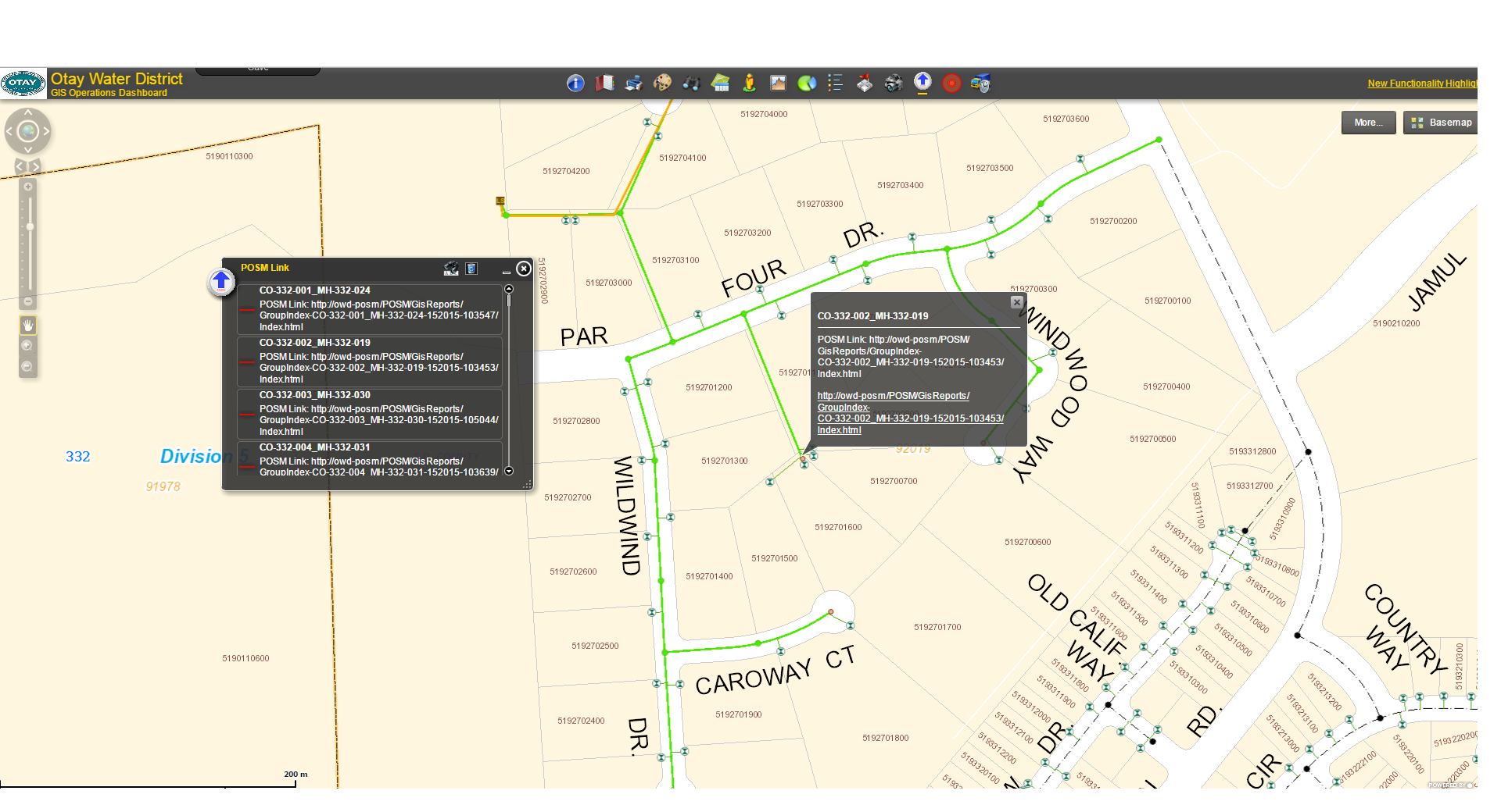
9 GIS data as the foundation District CCTV van with computer equipment and CCTV camera Unique ID was assigned to each pipe segment in GIS ArcReader application and CCTV interface /data management software (POSM) were installed in the van s computer GIS data was exported as the foundation to inspect the pipes
10 Operation to collect the inspection data Locate the pipe through ArcReader Prepopulate pipe information from GIS automatically Enter the inspection info into POSM POSM controls the CCTV camera Observations are entered PACP and MACP codes are automatically populated

11
12

13 Synch field data to GIS server Schedule the CCTV van to connect to network Synchronize the newly collected records into server database Maintain the database in the van periodically.

14 POSM server based database SQL server based Use FacilityID as the unique key Create a unique URL for inspection report for each segment Adopt the NASSCO rating standard
15 NASSCO standard for sewer system NASSCO - National Association of Sewer Service Companies Adopt the NAASSO Standard across the board Operation Engineering Asset Management program Promote Training and Certification Program in the District Pipeline Assessment and Certification Program (PACP) Manhole Assessment and Certification Program (MACP) Lateral Assessment and Certification Program (LACP)
16

17
18 Operation preventive maintenance Schedule the cleanup using the condition score Target more on the known area for high frequent maintenance Notify the property owner for lateral cleanup Develop a rehabilitation and replacement plan based on the inspection data Budget the replacement based on the condition score

19 Engineering Capital Improvement Plan Access the CCTV data through GIS viewers Access the observation report through GIS viewers Produce critical pipe segment report Asset Management Program
20
21
22

23
24
25 Conclusion and Future plan Leverage GIS and other new technology to manage the traditional utility maintenance program Integrate with Field Mobile GIS application (InfraMap) Integrate with Sewer Master Plan Integrate with CMMS Asset Management
26 Thank You! Contact info: Ming Zhao: GIS Manager Leonel Torres: GIS Analyst
ESRI CONFERENCE, JULY 2014, SAN DIEGO
 QUEBEC 'S CITY EFFICIENT DATA MAN OF THE SEWER SYSTEMS and its global approach to data m of municipal infrastructure asse ESRI CONFERENCE, JULY 2014, SAN DIEGO QUEBEC CITY 'SEFFICIENT DATA MANAGE THE SEWER
Affordable Asset Management Workshop Making Use of the Data You Have An Owners Perspective
 Affordable Asset Management Workshop Making Use of the Data You Have An Owners Perspective Building the Foundation for an Effective Asset Management Program Scott D. Kelly, P.E. Assistant City Administrator
Section 4 Pipe and Maintenance Hole Inspection and Condition Assessment Plan
 and Condition Assessment Plan 4.1 Introduction 4.1.1 Purpose This addresses the requirements of Section IV.A. of the EPA Order. The plan documents the progress that each agency has made to date regarding
DeKalb County, Georgia Evolution of Municipal Wastewater Asset Management Program. From Paper to CAD to ArcGIS and Beyond
 DeKalb County, Georgia Evolution of Municipal Wastewater Asset Management Program From Paper to CAD to ArcGIS and Beyond Darren S. Eastall Sean Kilpatrick DeKalb County, Georgia Brown and Caldwell Overview
WEAT Collections Conference January 22, 2014 NASSCO PACP/MACP/LACP- The Trainer s Perspective. Gerald Boman NASSCO PACP/MACP/LACP Certified Trainer
 WEAT Collections Conference January 22, 2014 NASSCO PACP/MACP/LACP- The Trainer s Perspective Gerald Boman NASSCO PACP/MACP/LACP Certified Trainer What is NASSCO? National Association of Sewer Service
GIS Applications for Regulatory Compliance
 4 GIS Applications for Regulatory Compliance Uzair (Sam) M. Shamsi Many cities in the world especially in the United States and Canada are dealing with regulatory enforcement actions for sewer overflows,
Info What? Using InfoMaster to Develop a Rehabilitation and Replacement Plan
 Info What? Using InfoMaster to Develop a Rehabilitation and Replacement Plan Amanda Lei - City of San Jose Alex Palmatier - HDR 2014 HDR, Inc., all rights reserved. Background Forecasting and Budget Data
LACKLAND AFB INVENTORY & CONDITION ASSESSMENT BASE SEWER COLLECTION &WATER DISTRIBUTION SYSTEMS
 LACKLAND AFB INVENTORY & CONDITION ASSESSMENT BASE SEWER COLLECTION &WATER DISTRIBUTION SYSTEMS Presenter: Ann Quinn ARCADIS / Malcolm Pirnie Date: May 12, 2011 Background Key Drivers AF implementation
Request for Proposals Sanitary Sewer System Condition Assessment (PILOT PROJECT)
") Request for Proposals Sanitary Sewer System Condition Assessment (PILOT PROJECT) Utilizing CCTV equipment, equipment use training, NASSCO PACP defect coding, and infrastructure program management software
Request for Proposals Sanitary Sewer System Condition Assessment (PILOT PROJECT) Utilizing CCTV equipment, equipment use training, NASSCO PACP defect coding, and infrastructure program management software
Implementing an Enterprise Asset Management System and Mobile Solution
 Implementing an Enterprise Asset Management System and Mobile Solution St. Johns County Utilities growth and expansion required implementing a mobile GIS enterprise Asset Management System (Cityworks),
ATTACHMENT 2: SPECIFICATION FOR SEWER CCTV VIDEO INSPECTION
 ATTACHMENT 2: SPECIFICATION FOR SEWER CCTV VIDEO INSPECTION 1.0 General 1.1 The work covered by this section consists of providing all labor, equipment, insurance, accessories, tools, transportation, supplies,
South Tahoe Public Utility District Job Description
 South Tahoe Public Utility District Job Description JOB TITLE: Underground Sewer Repair I & II UPDATED: 1/18/12 EFFECTIVE: 1/1/12 DEPT: Underground Sewer Repair APPROVED STPUD: NH APPROVED LOCAL 39: CS
THE ROLE OF GIS IN ASSET MANAGEMENT: INTEGRATION AT THE OTAY WATER DISTICT. Alexander John Schultz
 THE ROLE OF GIS IN ASSET MANAGEMENT: INTEGRATION AT THE OTAY WATER DISTICT by Alexander John Schultz A Thesis Presented to the FACULTY OF THE USC GRADUATE SCHOOL UNIVERSITY OF SOUTHERN CALIFORNIA In Partial
Implementing a Workflow Solution Leveraging SCADA and GIS/CMMS at the Waterford Township DPW. Charter Township of Waterford Oakland County, Michigan
 Implementing a Workflow Solution Leveraging SCADA and GIS/CMMS at the Waterford Township DPW Charter Township of Waterford Oakland County, Michigan DPW Assets 360 Miles of Water Main and Appurtenances
Organically Growing an Asset Management System in the City of Novi, Michigan
 Organically Growing an Asset Management System in the City of Novi, Michigan IMAGIN Conference 2015 Traverse City, Michigan City of Novi, Michigan - Location 2 1 City of Novi, Michigan Vital Statistics
SPRINGVILLE CITY, UTAH
 SPRINGVILLE CITY, UTAH REQUEST FOR PROPOSALS ENTERPRISE ASSET MANAGEMENT AND WORK ORDER SOFTWARE AND SERVICES RFP #2013 02 1 Table of Contents PROJECT BACKGROUND:... 4 SCOPE OF WORK:... 4 ALTERNATE SCOPE
A Solution to MOP/MAOP Data Management in PODS
 2013 Esri International User Conference July 8 12, 2013 San Diego, California A Solution to MOP/MAOP Data Management in PODS Chevron Pipe Line Company Nathan Marx, GIS Project Manager Marsh Wong, IT Systems
Functional Requirements of the Software
 Generic CCTV software Specifications for Granite XP Asset Management & Decision Support Software as provided by CUES Functional Requirements of the Software a. The inspection software shall fully support
Manhole Assessment. Pipeline Assessment and Certification Program (PACP) & Manhole Assessment Certification Program (MACP)
 & Manhole Assessment Certification Program (MACP)") Manhole Assessment Pipeline Assessment and Certification Program (PACP) & Manhole Assessment Certification Program (MACP) Ted DeBoda, PE NASSCO Executive Director Outline NASSCO Defects and Observations
Manhole Assessment Pipeline Assessment and Certification Program (PACP) & Manhole Assessment Certification Program (MACP) Ted DeBoda, PE NASSCO Executive Director Outline NASSCO Defects and Observations
Using GIS to Track and Prioritize Your Assets
 Using GIS to Track and Prioritize Your Assets What is GIS?? Geographic Information System Geographic Location of an asset Information Characteristics of an asset System Software that allows connection
Interactive Decision Tree Automates Sewer Rehabilitation Planning
 Interactive Decision Tree Automates Sewer Rehabilitation Planning IWPCA Annual Conference June 5, 2008 Rodney Moeller, P.E., John Schroeder, P.E. BCEE, C. Timothy Fallara, P.E. & Mel Meng, P.E. Agenda
4 Steps for Quality Sewer Performance in Perpetuity
 4 Steps for Quality Sewer Performance in Perpetuity By Gerhard Gerry P. Muenchmeyer, P. E. Principal Muenchmeyer Associates, LLC E-mail gerry@muenchmeyerassoc.com INTRODUCTION A well maintained and functional
Integrated GIS and Asset Management in Municipal Government. Presented by: Corinne Bexson, BGIS Senior GIS Technician Town of Rothesay
 Integrated GIS and Asset Management in Municipal Government Presented by: Corinne Bexson, BGIS Senior GIS Technician Town of Rothesay Outline Background Overview Research & Planning Implementation Phases
Gravity Line Preventative Maintenance Program
 Gravity Line Preventative Maintenance Program Lexington-Fayette Urban County Government Department of Environmental Quality Division of Water Quality December 2011 Gravity Line Preventative Maintenance
City of Winooski. Request for Proposals Department of Public Works ASSET MANAGEMENT SOFTWARE, IMPLEMENTATION AND TRAINING
 City of Winooski Request for Proposals Department of Public Works ASSET MANAGEMENT SOFTWARE, IMPLEMENTATION AND TRAINING Issued: February 29, 2016 Deadline for Submissions: 4:00 p.m., March 25, 2016 INTRODUCTION
Mount Laurel Township MUA Hydrant Maintenance Program. Using ArcPad to Track Hydrant Flow Testing and Flushing procedures
 Mount Laurel Township MUA Hydrant Maintenance Program Using ArcPad to Track Hydrant Flow Testing and Flushing procedures What is the Mount Laurel MUA? The Mount Laurel Township, Municipal Utilities Authority
Leveraging Cartegraph Data for the Management of Public Works Assets for the City of Grapevine
 Leveraging Cartegraph Data for the Management of Public Works Assets for the City of Grapevine Presented By: Suja Joseph & Julie Paine Public Works City of Grapevine Overview of Cartegraph System for the
How to Setup and Manage Spatial Assets with ArcGIS Online for a Mobile Workforce
 How to Setup and Manage Spatial Assets with ArcGIS Online for a Mobile Workforce W A U R I S A 2 0 1 4 Presented By Engineer Technician II Pierce County Public Works and Utilities Road Operations Division
REVISED SHORT TERM AND LONG TERM SEWER PIPE INSPECTION AND CONDITION ASSESSMENT PROGRAM SOUTH COAST WATER DISTRICT. June 2005
 REVISED SHORT TERM AND LONG TERM SEWER PIPE INSPECTION AND CONDITION ASSESSMENT PROGRAM SOUTH COAST WATER DISTRICT FOR SOUTH COAST WATER DISTRICT Prepared with the requirements identified in the United
ESRI and Xplore Technologies 2008 Mobile Government Demonstration Project Grant Program Final Report
 ESRI and Xplore Technologies 2008 Mobile Government Demonstration Project Grant Program Final Report Introduction and Project Purpose The ESRI and Xplore Technologies Mobile Government Demonstration Project
Section 2651 Television Inspection
 Section 2651 Television Inspection PART 1: General 1.1 Description Provide all labor, materials, tools, equipment and incidentals as shown, specified, and required to perform television (TV) inspection
Using Risk-Based GIS Modeling Software to Optimize Sewer Renewal Planning
 Close Using Risk-Based GIS Modeling Software to Optimize Sewer Renewal Planning By Paul F. Boulos Rapid population growth and the deterioration of aging infrastructures are overtaxing sewer systems worldwide.
STANDARD SPECIFICATIONS SECTION 02956 CLOSED CIRCUIT TELEVISION INSPECTION OF SEWER MAINS, MANHOLES AND LATERALS
 STANDARD SPECIFICATIONS SECTION 02956 CLOSED CIRCUIT TELEVISION INSPECTION OF SEWER MAINS, MANHOLES AND LATERALS PART 1 GENERAL 1.1 DESCRIPTION A. Section includes requirements to execute internal closed
Jeff Haby, P.E. Director Sewer System Improvements. September 15, 2015. Agenda
 SAWS Sanitary Sewer Overflow Reduction Program Jeff Haby, P.E. Director Sewer System Improvements SA Military Engineers Meeting Agenda SAWS Overview Consent Decree CD Compliance Programs Program Transition
City of Ridgecrest. Wastewater Treatment Facility Request for Proposal Sewer Collection System Condition Assessment
 City of Ridgecrest Wastewater Treatment Facility Request for Proposal Sewer Collection System Condition Assessment Proposals Due: Wednesday March 19, 2014 2:00 pm City of Ridgecrest Wastewater Treatment
Asset Management for MAP-21. Gary Lasham, P.E. Jonathan Pollack
 Asset Management for MAP-21 Gary Lasham, P.E. Jonathan Pollack Replaced Intermodal Surface Transportation Efficiency Act (ISTEA) MAP-21 is transforming the policy and programmatic framework for investments
SAN JOSE CAPITAL OF SILICON VALLEY
 T&E Committee: 11/03/2014 Item: (d) (5) CITY OF SAN JOSE CAPITAL OF SILICON VALLEY TO: TRANSPORTATION AND ENVIRONMENT COMMITTEE SUBJECT: SEE BELOW Memorandum FROM: Keme Romanow DATE: October 17,2014 Approved
Reducing Costs and Raising Effectiveness with a GIScentric Asset Management System
 Reducing Costs and Raising Effectiveness with a GIScentric Asset Management System Jay Clark GIS Specialist City of Shoreline jclark@shorelinewa.gov Chris Brussow Account Manager Cityworks cbrussow@cityworks.com
STANDARD SPECIFICATIONS SECTION 02956 CLOSED CIRCUIT TELEVISION INSPECTION OF SEWER MAINS, MANHOLES AND LATERALS
 STANDARD SPECIFICATIONS SECTION 02956 CLOSED CIRCUIT TELEVISION INSPECTION OF SEWER MAINS, MANHOLES AND LATERALS PART 1 GENERAL 1.1 DESCRIPTION A. Section includes requirements to execute internal closed
REQUEST FOR PROPOSAL 2011-005-580 ADDENDUM B. Integrated Utility Enterprise Resource Planning (ERP) System
 System") REQUEST FOR PROPOSAL 2011-005-580 ADDENDUM B FIRMS MUST ACKNOWLEDGE RECEIPT OF THIS ADDENDUM WITH YOUR PROPOSAL Integrated Utility Enterprise Resource Planning (ERP) System Questions and Answers, Clarifications/Revisions,
REQUEST FOR PROPOSAL 2011-005-580 ADDENDUM B FIRMS MUST ACKNOWLEDGE RECEIPT OF THIS ADDENDUM WITH YOUR PROPOSAL Integrated Utility Enterprise Resource Planning (ERP) System Questions and Answers, Clarifications/Revisions,
Affordable Asset Management Making Use of the Data You Have: An Owner s Perspective
 Affordable Asset Management Making Use of the Data You Have: An Owner s Perspective An Owner Operator s Approach for Asset Management on a Budget Lane Longley, City of St. Petersburg Presented by the April
INTRODUCTION. WASTEWATER MANAGEMENT PLAN MAY 2009 Metropolitan North Georgia Water Planning District 7-1
 INTRODUCTION There are approximately 16,000 miles of sewers and more than 450,000 manholes within the Metro Water District. Sewers and manholes within the Metro Water District range in age from new to
Condition Assessment of Underground Pipes April 2015 With excerpts from: Condition Assessment of Wastewater Collection Systems, EPA/600/R-09/049
 Condition Assessment of Underground Pipes April 2015 With excerpts from: Condition Assessment of Wastewater Collection Systems, EPA/600/R-09/049 EPA New England Water Infrastructure Outreach provides tools,
Improving Access to GIS Data With Targeted Web Apps. Joyce Green, City of Norman John McIntosh, City of Norman
 Improving Access to GIS Data With Targeted Web Apps Joyce Green, City of Norman John McIntosh, City of Norman Improving Access to GIS Data with Targeted Web Apps Background Objective Development Environment
Network Analysis with ArcGIS Online
 Federal GIS Conference February 9 10, 2015 Washington, DC Network Analysis with ArcGIS Online Matt Kennedy Topics Online versus on-premise network analysis services How to access online services How to
Using Frequent Sewer Inspection to Prioritize Asset Management. May 1, 2014. John Schroeder, P.E., BCEE Drew Richards, EI Tim Fallara, P.E.
 Using Frequent Sewer Inspection to Prioritize Asset Management May 1, 2014 John Schroeder, P.E., BCEE Drew Richards, EI Tim Fallara, P.E. Agenda Rationale and Goals for Sewer Re-inspection How and why
Using CAD Data in ArcGIS
 Esri International User Conference San Diego, California Technical Workshops July 27, 2012 Using CAD Data in ArcGIS Jeff Reinhart & Phil Sanchez Agenda Overview of ArcGIS CAD Support Using CAD Datasets
Presented By: Justin Cira MTech Company. Your future, Condition Assessment and Sewer Asset Management tool
 Presented By: Justin Cira MTech Company Your future, Condition Assessment and Sewer Asset Management tool Digital Side Scanning Camera Digital Side Scanning WhaT is it? New generation of HD High Definition
White Paper. www.geodecisions.com
 White Paper www.geodecisions.com A Geo Spatial Total Asset Management System (TAMS) To Improve Asset Management Decision Making Fall 2013 Abstract This paper describes a Geospatial Total Asset Management
SEWER CLEANING, INSPECTION AND ASSESSMENT
 3.1 OVERVIEW Chapter 3 SEWER CLEANING, INSPECTION AND ASSESSMENT Preventive maintenance protects the investment of the sanitary sewer collection system infrastructure. Higher frequency cleaning of gravity
San Diego State University Takes Utility Master Planning to the Next Level. Glenn Vorraro, SDSU Doug Henstridge / Jon Schwartz, Jacobs Carter Burgess
 San Diego State University Takes Utility Master Planning to the Next Level Glenn Vorraro, SDSU Doug Henstridge / Jon Schwartz, Jacobs Carter Burgess Background Located to the northeast of downtown San
Agenda. What is GIS? GIS and SAP Real Examples
 Agenda What is GIS? GIS and SAP Real Examples Life Without GIS My Stuff My Paper Maps Features Three Elements of a GIS Attributes What parcels are adjacent to Main Street? Behavior Display Query Analysis
Kingdom Of Bahrain Ministry of Works. Enterprise Asset Management System A Geocentric Approach. Presented By Hisham Y.
 Kingdom Of Bahrain Ministry of Works Enterprise Asset Management System A Geocentric Approach Presented By Hisham Y. Sater April 2012 Ministry Of Works Bahrain MOW The construction arm of the Kingdom of
Improving Collaboration, Efficiency, and Transparency in Hamilton County
 Improving Collaboration, Efficiency, and Transparency in Hamilton County (GIS in the Cloud) Hamilton County Department of Planning and Development Ileana Abot, GISP Former GIS Manager 1 Agenda v Project
CCTV INSPECTION OF SEWER LINES. A. Section 02730 Sanitary Gravity Sewer Lines. B. Section 02731 Sanitary Gravity Sewer Line Testing
 CCTV INSPECTION OF SEWER LINES PART 1 GENERAL 1.1 SECTION INCLUDES A. CCTV Inspections 1.2 RELATED SECTIONS A. Section 02730 Sanitary Gravity Sewer Lines B. Section 02731 Sanitary Gravity Sewer Line Testing
GIS and Document Management Integration
 GIS and Document Management Integration Presented by: Steve Sherman, GISP City of Greensboro, NC ESRI Conference 2007 Presentation Goals Definition of Document Management What it is? Why it s s important
ArcPad a new tool for Asset Inventory/Management at Nevada DOT. Eric Warmath GIS Program Manager, NDOT
 ArcPad a new tool for Asset Inventory/Management at Nevada DOT Eric Warmath GIS Program Manager, NDOT Topics Historical Data Collection Methods Current Methodology Operator Safety Issues Add on Technologies
Enhancing Asset Management with a GIS Program. Lori A. Burkert, P.G. lburkert@entecheng.com 610-373-6667
 Enhancing Asset Management with a GIS Program Lori A. Burkert, P.G. lburkert@entecheng.com 610-373-6667 presentation overview Definitions Its all about your assets Components of a GIS Why use GIS for asset
Durango Migrates its Infrastructure GIS to an Asset Management System
 Durango Migrates its Infrastructure GIS to an Asset Management System Rick Szmajter, GISP City of Durango Colorado ESRI International User Conference San Diego, CA July 22, 2015 rick.szmajter@durangogov.org
The Redwood City Public Works Services (PWS) Department is comprised of four operating divisions:
 Department is comprised of four operating divisions:") City of Redwood City, Public Works Services (PWS) Work Process Needs Assessment By: Russell Narahara, Management Analyst II The purpose of this document is to provide an overview of how field work is currently
City of Redwood City, Public Works Services (PWS) Work Process Needs Assessment By: Russell Narahara, Management Analyst II The purpose of this document is to provide an overview of how field work is currently
White Paper. Freeance Mobile for Cityworks
 White Paper Freeance Mobile for Cityworks Version 1.1 May 2012 Freeance Mobile for Cityworks Freeance Mobile for Cityworks 2012.1 is a mobile application for the following smartphones and tablets: iphone
CITY OF POWAY REQUEST FOR PROPOSALS (RFP) FOR GEOGRAPHIC INFORMATION SYSTEM (GIS) WATER / WASTEWATER SYSTEM DATA CONVERSION PROJECT ADDENDUM SIX
 FOR GEOGRAPHIC INFORMATION SYSTEM (GIS) WATER / WASTEWATER SYSTEM DATA CONVERSION PROJECT ADDENDUM SIX") CITY OF POWAY REQUEST FOR PROPOSALS (RFP) FOR GEOGRAPHIC INFORMATION SYSTEM (GIS) WATER / WASTEWATER SYSTEM DATA CONVERSION PROJECT ADDENDUM SIX In reference to the Request for Proposals for Geographic
CITY OF POWAY REQUEST FOR PROPOSALS (RFP) FOR GEOGRAPHIC INFORMATION SYSTEM (GIS) WATER / WASTEWATER SYSTEM DATA CONVERSION PROJECT ADDENDUM SIX In reference to the Request for Proposals for Geographic
Disaster Resilient GIS Aids Port Security and Benefits All Stakeholders. Eric Napralla, Port of Oakland Cassandra Gray, NorthSouth GIS
 Disaster Resilient GIS Aids Port Security and Benefits All Stakeholders Eric Napralla, Port of Oakland Cassandra Gray, NorthSouth GIS The Port of Oakland at a Glance Enterprise agency of the City of Oakland,
Utilizing Remaining Useful Life for Asset Management of Critical Wastewater Assets
 *Jessica Brown, P.E., Freese and Nichols, Inc., (817) 312-6980; Jessica.Brown@freese.com Mazen Kawasmi, Freese and Nichols, Inc. ABSTRACT The City of Fort Worth s wastewater collection system includes
City of Grand Junction and inframap Software Mobile Field Application
 1 City of Grand Junction and inframap Software Mobile Field Application City Of Grand Junction Grand Junction Colorado Scott List inframap Software Adam Hagee Colin Kennedy Grand Junction Background 2
KAREN E. RUSHING. Clerk of the Circuit Court and County Comptroller. Audit Services. Karen E. Rushing
 KAREN E. RUSHING Clerk of the Circuit Court and County Comptroller AUDIT OF Sarasota County s Computerized Maintenance Management System (Maximo) Audit Services Karen E. Rushing Clerk of the Circuit Court
Municipal Maintenance and Infrastructure Asset Management Systems
 Water Finance RESEARCH FOUNDATION The 2012 Comparative Review Municipal Maintenance and Infrastructure Asset Management Systems This study includes a comparative review of Accela, Agile Assets, Azteca
Sanitary Sewer Management Plan (SSMP)
") Sanitary Sewer Management Plan (SSMP) SALT LAKE CITY DEPARTMENT OF PUBLIC UTILITIES Table of Contents Preface 1 Goals... 3 Definitions and General Requirements.. 4 Part 1 Organization 6 1.1 SLCDPU Organization...
Sanitary Sewer Management Plan (SSMP) SALT LAKE CITY DEPARTMENT OF PUBLIC UTILITIES Table of Contents Preface 1 Goals... 3 Definitions and General Requirements.. 4 Part 1 Organization 6 1.1 SLCDPU Organization...
Collaborative Asset Management System (CAMS) Load Balancer Solution. Request for Proposal (RFP) Distributed by:
 Load Balancer Solution. Request for Proposal (RFP) Distributed by:") Collaborative Asset Management System (CAMS) Load Balancer Solution Request for Proposal (RFP) Distributed by: Oakland County Information Technology 1200 N. Telegraph Road, Bldg. 49W Pontiac, MI 48341
Collaborative Asset Management System (CAMS) Load Balancer Solution Request for Proposal (RFP) Distributed by: Oakland County Information Technology 1200 N. Telegraph Road, Bldg. 49W Pontiac, MI 48341
INCOG Transportation Planning Division Spatial Data Management Workflow GIS-T 2008
 INCOG Transportation Planning Division Spatial Data Management Workflow GIS-T 2008 Kevin Tartar, GISP Transportation Geodatabase Coordinator 201 West 5th Street, Suite 600 Tulsa, Oklahoma 74103 Phone:
Esri Maps for Business Intelligence (BI)
") 2013 Esri International User Conference July 8 12, 2013 San Diego, California Technical Workshop Esri Maps for Business Intelligence (BI) Pierre Seguin Patrick Brennan Esri UC2013. Technical Workshop.
2013 Esri International User Conference July 8 12, 2013 San Diego, California Technical Workshop Esri Maps for Business Intelligence (BI) Pierre Seguin Patrick Brennan Esri UC2013. Technical Workshop.
ARIZONA DEPARTMENT OF TRANSPORTATION. Presented by Lonnie D. Hendrix, P.E. Assistant State Engineer, Maintenance
 ARIZONA DEPARTMENT OF TRANSPORTATION Presented by Lonnie D. Hendrix, P.E. Assistant State Engineer, Maintenance Prepared by Feature Inventory Services Team July 2013 FIS Database Feature Inventory System
SECTION 02732 CLEANING AND CLOSED CIRCUIT TELEVISION (CCTV) INSPECTION OF SEWER PIPE
 INSPECTION OF SEWER PIPE") SECTION 02732 CLEANING AND CLOSED CIRCUIT TELEVISION (CCTV) INSPECTION OF SEWER PIPE PART 1 - GENERAL 1.01 WORK INCLUDED A. This section covers the initial and final cleaning, and the initial and final
SECTION 02732 CLEANING AND CLOSED CIRCUIT TELEVISION (CCTV) INSPECTION OF SEWER PIPE PART 1 - GENERAL 1.01 WORK INCLUDED A. This section covers the initial and final cleaning, and the initial and final
1. Abstract. 2. The Problem / Need for the Program
 Program Information: Montgomery County, Maryland Program Title: Integration of GIS Web Services with the 311 Call Center Program Category: # 14 Information Technology 1. Abstract Montgomery County s Department
City of Los Altos Sewer System Management Plan
 City of Los Altos Sewer System Management Plan February 2015 This page intentionally left blank. LIST OF REVISIONS Revision No. 2 3 4 Description of Revision Revision of telephone numbers and text issues,
Job description: Geographic Information Systems (GIS) Analyst, S20 Location: Washington Dulles International Airport
 Analyst, S20 Location: Washington Dulles International Airport") S10961A, page 1 Nothing in this job description restricts management's right to assign or reassign duties and responsibilities to this job at any time. DUTIES Serves as a Geographic Information Systems
S10961A, page 1 Nothing in this job description restricts management's right to assign or reassign duties and responsibilities to this job at any time. DUTIES Serves as a Geographic Information Systems
Setting the Standard for Safe City Projects in the United States
 Leading Safe Cities Setting the Standard for Safe City Projects in the United States Edge360 is a provider of Safe City solutions to State & Local governments, helping our clients ensure they have a secure,
WILLAMALANE PARK AND RECREATION DISTRICT. Springfield, Oregon GIS ASSET MANAGEMENT IN A PARK AND RECREATION DISTRICT ESRI USER CONFERENCE JULY 2014
 WILLAMALANE PARK AND RECREATION DISTRICT Springfield, Oregon GIS ASSET MANAGEMENT IN A PARK AND RECREATION DISTRICT ESRI USER CONFERENCE JULY 2014 SESSION GOALS Share our process of implementing and developing
Cloud Nine: Developing an Entirely Cloud Based GIS, Asset Management and Work Order System
 Cloud Nine: Developing an Entirely Cloud Based GIS, Asset Management and Work Order System Corrie Bondar 1*, Mark Valentino 2 1 Freese and Nichols, Inc., Raleigh, North Carolina 2 Freese and Nichols, Inc.,
10 GEOMATICS BUSINESS SOLUTIONS - ANNUAL REPORT 2005
 10 GEOMATICS BUSINESS SOLUTIONS - ANNUAL REPORT 2005 The Planning and Economic Development Committee recommends the adoption of the recommendation contained in the following report January 30, 2006, from
Request For Proposal. GIS Optimization
 Request For Proposal GIS Optimization Oak Creek, Wisconsin August 25, 2015 TABLE OF CONTENTS Page I. INTRODUCTION... 1 II. PROJECT DETAILS... 1 III. GENERAL SCOPE OF SERVICES... 2 IV. SUBMITTAL REQUIREMENTS
Network Analysis with ArcGIS for Server
 Esri International User Conference San Diego, California Technical Workshops July 24, 2012 Network Analysis with ArcGIS for Server Deelesh Mandloi Dmitry Kudinov Introduction Who are we? - Network Analyst
ArcGIS Pro. James Tedrick, Esri
 ArcGIS Pro James Tedrick, Esri What you already know Why ArcGIS PRO? Vision The next generation ArcGIS desktop application for the GIS community who need a clean and comprehensive user experience which
GeoManitoba Spatial Data Infrastructure Update. Presented by: Jim Aberdeen Shawn Cruise
 GeoManitoba Spatial Data Infrastructure Update Presented by: Jim Aberdeen Shawn Cruise Organization Overview Manitoba Innovation Energy and Mines Business Transformation and Technology (BTT) Application
INTEGRATING BIM AND GIS FOR ASSET MANAGEMENT
 INTEGRATING BIM AND GIS FOR ASSET MANAGEMENT Andy Chan MHKIBIM Project Manager Spatial Technology Limited Agenda Introduction of Asset Management Why GIS is not sufficient for Asset Management Data model
Asset Inspection / Decision Support Software for the Water, Wastewater, & Stormwater Industries
 Asset Inspection / Decision Support Software for the Water, Wastewater, & Stormwater Industries Version 032811 ABOUT CUES The Leading Manufacturer of Pipeline Inspection & Rehabilitation Systems for Over
Modeling Sewer Pipe Deterioration for Risk Based Planning using a Markov Chain Model. Christopher Pawlowski Shawn Loew
 Modeling Sewer Pipe Deterioration for Risk Based Planning using a Markov Chain Model Christopher Pawlowski Shawn Loew August 27, 2014 Asset Management Using Risk Based Planning Limited Funds Unlimited
City of Mill Valley Sewer Capital Improvement Plan 2012 2016
 City of Mill Valley Sewer Capital Improvement Plan 2012 2016 I. BACKGROUND Between December 2004 and February 2008, the ed States Environmental Protection Agency (EPA) conducted inspections of the SASM
AV-18 Introduction of the GIS Integration
 Slide 1 AV-18 Introduction of the GIS Integration Authors Victor Lough Dan Marsillo Geoff Tarcha social.invensys.com @InvensysOpsMgmt / #SoftwareRevolution /InvensysVideos /InvensysOpsMgmt /company/invensys
Even Cowboys Need Good Data City of Pendleton GIS Development
 Even Cowboys Need Good Data City of Pendleton GIS Development Presenters: Bob Patterson, P.E., City of Pendleton David Stangel, P.E., Murray, Smith & Assoc. Inc. Project Overview Create GIS Databases for
City of San Diego Water Demand Forecast
 Presentation to Scripps Institute of Oceanography City of San Diego Water Demand Forecast Public Utilities Department Engineering Program Management Division Feryal Moshavegh, Associate Engineer Michael
Request for Statement of Qualifications and Information (RFQI) Public Works Enterprise Asset Management / Work Order Software.
 Public Works Enterprise Asset Management / Work Order Software.") Request for Statement of Qualifications and Information (RFQI) Public Works Enterprise Asset Management / Work Order Software. RFQI Submittals Due Thursday, April 28, 2016 by 4:00 PM CONTACT: Chris Bethel,
Request for Statement of Qualifications and Information (RFQI) Public Works Enterprise Asset Management / Work Order Software. RFQI Submittals Due Thursday, April 28, 2016 by 4:00 PM CONTACT: Chris Bethel,
SEWER WATER SUCCESS MAPPING MUNICIPAL. GIS and mapping technologies help the City of Long Beach chart a true course PAGE 20
 MUNICIPAL SEWER & WATER TM TECHNOLOGY TEST DRIVE: VACTOR 2100PLUS COMBINATION TRUCK PAGE 40 HUMAN SIDE: EARNING LOYALTY FOR LIFE PAGE 44 BETTER MOUSETRAPS: PRECHLORINATED PIPE BURSTING PAGE 36 FOR SANITARY,
REQUEST FOR PROPOSALS SANITARY SEWER MAINTENANCE SERVICES FOR THE TOWN CENTER SEWER ASSESSMENT DISTRICT WITHIN THE TOWN OF WOODSIDE
 REQUEST FOR PROPOSALS SANITARY SEWER MAINTENANCE SERVICES FOR THE TOWN CENTER SEWER ASSESSMENT DISTRICT WITHIN THE TOWN OF WOODSIDE Submit Proposals to: Town of Woodside Public Works Department 2955 Woodside
A Web services solution for Work Management Operations. Venu Kanaparthy Dr. Charles O Hara, Ph. D. Abstract
 A Web services solution for Work Management Operations Venu Kanaparthy Dr. Charles O Hara, Ph. D Abstract The GeoResources Institute at Mississippi State University is leveraging Spatial Technologies and
ArcGIS Workflow Manager: An Overview
 Federal GIS Conference February 9 10, 2015 Washington, DC ArcGIS Workflow Manager: An Overview Heather Murnane & Elizabeth Wilcox Session Topics Overview Key Features Notification & Reporting Overview
Connecting Space and Time OSIsoft & Esri
 Connecting Space and Time OSIsoft & Esri Presented by Michelle Kuiee Product Manager 2 3 Which of these describe your need? Operating Engineers & Analysts Evironmental Heath and Safety Maintenance Coordinators
Esri Maps for Salesforce and Microsoft Dynamics CRM
 Esri Maps for Salesforce and Microsoft Dynamics CRM Daniel Lee, Lucy Guerra Esri UC 2014 Technical Workshop Agenda CRM and Esri Esri Maps for Demos Road Ahead Esri UC 2014 Technical Workshop Esri Maps
TOWN OF HILLSBOROUGH Compliance with Regulatory Mandates. Private Sewer Lateral Inspection and Repair Program
 TOWN OF HILLSBOROUGH Compliance with Regulatory Mandates Private Sewer Lateral Inspection and Repair Program SEWER SYSTEM- BACKGROUND 116 miles of gravity sanitary sewer pipelines 1 mile of force main
Sanitary District No. 1 of Marin County Infrastructure Asset Management Plan
 Sanitary District No. 1 of Marin County Infrastructure Asset Management Plan October 1, 2013 RWQCB Order No. R2-2013-0020 Prepared by in association with Schaaf & Wheeler JDH Corrosion Humphrey Consulting