Agenda. What is GIS? GIS and SAP Real Examples
|
|
|
- Marvin Fleming
- 10 years ago
- Views:
Transcription
1 Agenda What is GIS? GIS and SAP Real Examples

2 Life Without GIS My Stuff My Paper Maps

3 Features Three Elements of a GIS Attributes What parcels are adjacent to Main Street? Behavior Display Query Analysis Feature Characteristics Building type Appraised Value Parcel owner Unimproved lots are displayed in blue What parcels adjacent to Main St. are also zoned mixed use?

4 Features Buildings Topography Road Centerlines Parcels A GIS models reality digitally Abstraction of real-world features Communicates locational & descriptive info Portrays spatial relationships Utility Services GIS ID Pump 1 2 3

5 ~100 Layers Features: Facility Data -NASA

6 Features: Buildings/Equip

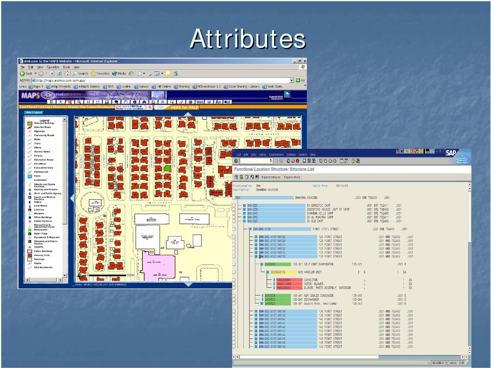
7 Attributes Attributes are information about a feature Feature characteristics Display and label characteristics Attributes Feature Characteristics Building type Display and Label Characteristics Appraised Value Parcel owner

8 Attributes
9 Behavior

10 Behavior

11 Spatial Data Management Organization and management of spatial information Accommodate all spatial data types Integrate all spatial data types Manage all spatial data types Data Creation Rules and Behavior Metadata Data Maintenance Editing tools GIS CAD Etc.. Editing workflows Model Builder PLTS Data sharing and distribution Spatial data repositories Replication, Versioning, Check in/out Persist all spatial types Oracle, SQL Server, DB2, Access, Files 3D Objects Topology Vectors Terrain Networks Cartography Surveys Images Addresses CAD Annotation Cadastral Geodatabase: Object-relational information model responsible for managing all geographic data types and their associative rules and behaviors. Attribute Dimensions

12 Spatial Data Management : CAD Data Type CAD Editing CAD Conversion CAD CAD Rendering

13 Spatial Data Management : Workflow

14 GIS and SAP Integrated Platforms Attributes SAP Ad-hoc Analysis Updates & Transactions ID 1 2 Equipment Reporting 3 Features Integration Sales Forecast + Modeling GIS Updates & Transactions ID 1 2 Transformer Operations 3

15 Linking Geospatial Features and SAP Attributes Each geographic feature has a record in an associated attribute table within SAP Buildings Roads Spatial Data Features Administrative Areas Water Services Linkage Roads SAP Attribute Data Buildings Administrative Areas

16 Mobile Real Property Parcel Building Utilization Spatial Reference Integration Scenarios Asset Management Equipment ID Account depreciation Spatial Reference Maintenance Work order Equipment history Spatial Reference Environmental Health And Safety Source Material Type Reporting Spatial Reference Tabular Information Logistics Inventory ID Routing Spatial Reference Projects WBS # Network Spatial Reference Incident Management Incident # Incident Type Spatial Reference

17 SAP NetWeaver Integration Points SAP NetWeaver INTEGRATION OF PEOPLE Multichannel access Composite Application Framework Portal Collaboration INTEGRATION OF INFORMATION Bus. Intelligence Master Data Management Knowledge Mgmt INTEGRATION OF PROCESSES Integration Broker APPLICATION PLATFORM Business Process Mgmt Life Cycle Management J2EE ABAP

18 Three Different Types of Users SAP User Composite User GIS User SAP Functionalities and Connections Composite Business Processes and Services GIS Functionalities and Connections SAP Data Synchronization and Distribution GIS

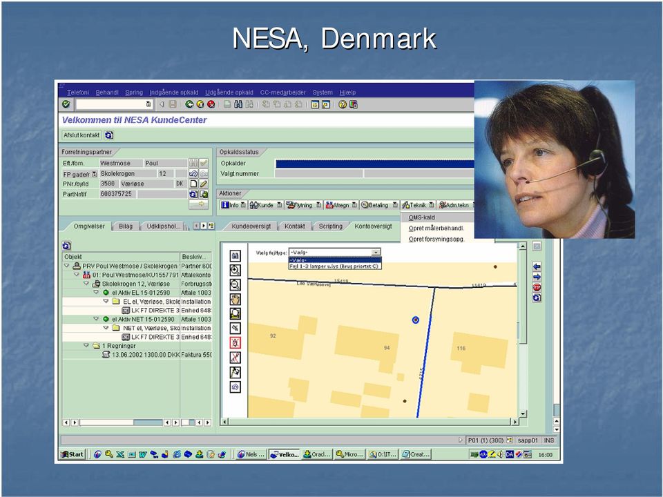
19 NESA, Denmark
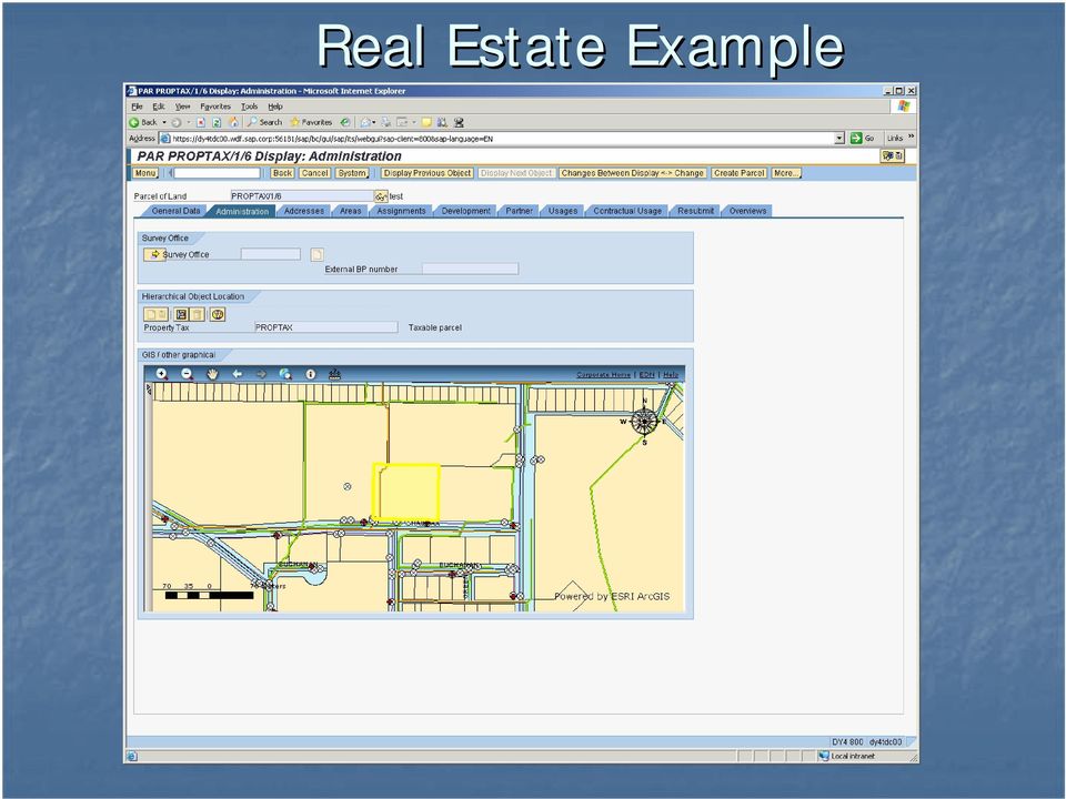
20 Real Estate Example
21 PSE&G Selected Circuit From GIS In Blue Selected Transformer Related Data From SAP
22 Real Estate Example
23 San Diego Streetlight SAP List of all Functional Locations, attached Equipment, and Bill of Material Drainage Inlet Drainage Inlet Drainage Inlet
24 Real Estate Example
25 Real Estate Example Call GIS from SAP SAP ArcGIS
26 New Possibilities: Netweaver XI SAP Data Within Map
27 New Possibilities: Vehicle Tracking Composite
28 Typical Project Management : Schedule for each element in the Work Breakdown Structure (WBS)
29 GIS Enhanced Project Management Potential problem areas (orange on this map)
30 Managing Problems Request for Information Log RFIs Mapped to Project Problem Hotspots
31 An Improved Way to Visualize Projects
Kingdom Of Bahrain Ministry of Works. Enterprise Asset Management System A Geocentric Approach. Presented By Hisham Y.
 Kingdom Of Bahrain Ministry of Works Enterprise Asset Management System A Geocentric Approach Presented By Hisham Y. Sater April 2012 Ministry Of Works Bahrain MOW The construction arm of the Kingdom of
GIS Databases With focused on ArcSDE
 Linköpings universitet / IDA / Div. for human-centered systems GIS Databases With focused on ArcSDE Imad Abugessaisa [email protected] 20071004 1 GIS and SDBMS Geographical data is spatial data whose
Basics on Geodatabases
 Basics on Geodatabases 1 GIS Data Management 2 File and Folder System A storage system which uses the default file and folder structure found in operating systems. Uses the non-db formats we mentioned
Basic GIS Modeling: Improving Campus Maintenance, Management, and Planning August 8 th, 2007. Matt Davis [email protected]
 NCFMTC- Modeling Your Campus Basic GIS Modeling: Improving Campus Maintenance, Management, and Planning August 8 th, 2007 Matt Davis [email protected] 1 Abstract Basic GIS Modeling: Improving Campus Maintenance,
An ESRI White Paper December 2007 Enterprise GIS for Local Government
 An ESRI White Paper December 2007 Enterprise GIS for Local Government ESRI 380 New York St., Redlands, CA 92373-8100 USA TEL 909-793-2853 FAX 909-793-5953 E-MAIL [email protected] WEB www.esri.com Copyright
http://www.esri.com/bia
 ArcGIS for Tribal Transportation Management David Gadsden Federal Account Manager [email protected] d d 1 David Gadsden GIS Background UW Geography (1995) Peace Corps Tanzania Environmental Social Science
Using CAD Data in ArcGIS
 Esri International User Conference San Diego, California Technical Workshops July 27, 2012 Using CAD Data in ArcGIS Jeff Reinhart & Phil Sanchez Agenda Overview of ArcGIS CAD Support Using CAD Datasets
Primavera Project Management System at WVDOT. Presented by Marshall Burgess, WVDOT Stephen Cole, Stephen Cole Consulting Jervetta Bruce, CDP, Inc.
 : Integrating GIS With Primavera Project Management System at WVDOT Presented by Marshall Burgess, WVDOT Stephen Cole, Stephen Cole Consulting Jervetta Bruce, CDP, Inc. WVDOT Geographic Information System
GIS Solutions for FTTx Design. David Nelson, GISP
 GIS Solutions for FTTx Design David Nelson, GISP Telecom GIS Manager, Black & Veatch Agenda Intro to GIS Telecom GIS Vision GIS Strategy Project Execution Mobile Online Services Dashboards Client Deliverables
Geodatabase Programming with SQL
 DevSummit DC February 11, 2015 Washington, DC Geodatabase Programming with SQL Craig Gillgrass Assumptions Basic knowledge of SQL and relational databases Basic knowledge of the Geodatabase We ll hold
Integrating GIS within the Enterprise Options, Considerations and Experiences
 Integrating GIS within the Enterprise Options, Considerations and Experiences Enterprise GIS Track Enrique Yaptenco Carsten Piepel Bruce Rowland Mark Causley Agenda Business Drivers and Requirements Key
ArcGIS Workflow Manager: An Overview
 Federal GIS Conference February 9 10, 2015 Washington, DC ArcGIS Workflow Manager: An Overview Heather Murnane & Elizabeth Wilcox Session Topics Overview Key Features Notification & Reporting Overview
Spatial data models (types) Not taught yet
 Not taught yet") Spatial data models (types) Not taught yet A new data model in ArcGIS Geodatabase data model Use a relational database that stores geographic data A type of database in which the data is organized across
Spatial data models (types) Not taught yet A new data model in ArcGIS Geodatabase data model Use a relational database that stores geographic data A type of database in which the data is organized across
The Redwood City Public Works Services (PWS) Department is comprised of four operating divisions:
 Department is comprised of four operating divisions:") City of Redwood City, Public Works Services (PWS) Work Process Needs Assessment By: Russell Narahara, Management Analyst II The purpose of this document is to provide an overview of how field work is currently
City of Redwood City, Public Works Services (PWS) Work Process Needs Assessment By: Russell Narahara, Management Analyst II The purpose of this document is to provide an overview of how field work is currently
Big Data and Analytics: Getting Started with ArcGIS. Mike Park Erik Hoel
 Big Data and Analytics: Getting Started with ArcGIS Mike Park Erik Hoel Agenda Overview of big data Distributed computation User experience Data management Big data What is it? Big Data is a loosely defined
ArcGIS Data Models Practical Templates for Implementing GIS Projects
 ArcGIS Data Models Practical Templates for Implementing GIS Projects GIS Database Design According to C.J. Date (1995), database design deals with the logical representation of data in a database. The
Personal Geodatabase 101
 Personal Geodatabase 101 There are a variety of file formats that can be used within the ArcGIS software. Two file formats, the shape file and the personal geodatabase were designed to hold geographic
 Using the Spatial Database Engine to develop a FEMA friendly Database and Asset Management Tool José Maria Guzmán, PE February 2009 GAFM 4th Annual Technical Conference Columbus, GA Outline Typical Datasets
Leveraging Cloud-Based Mapping Solutions
 Leveraging Cloud-Based Mapping Solutions GeoAlberta October 28, 2014 Laura Kerssens Safe Software Agenda To the Cloud Using Basic Services Cloud Applications Web Services Cloud-Hosted Databases Real-time
2010 Oracle Corporation 1
 1 Introduction to Geospatial Visualization in Oracle Business Intelligence Enterprise Edition, 11g Product Mgmt., Oracle Business Intelligence and Spatial Agenda Introduction When
Database Production and Map Series Management. Using. The Production Line Tool Set
 Database Production and Map Series Management Using The Production Line Tool Set Dewey Marino - ESRI Redlands Production Line Tool Set ArcGIS Solution for high volume database and map creation Creates
Digital Cadastral Maps in Land Information Systems
 LIBER QUARTERLY, ISSN 1435-5205 LIBER 1999. All rights reserved K.G. Saur, Munich. Printed in Germany Digital Cadastral Maps in Land Information Systems by PIOTR CICHOCINSKI ABSTRACT This paper presents
Cookbook 23 September 2013 GIS Analysis Part 1 - A GIS is NOT a Map!
 Cookbook 23 September 2013 GIS Analysis Part 1 - A GIS is NOT a Map! Overview 1. A GIS is NOT a Map! 2. How does a GIS handle its data? Data Formats! GARP 0344 (Fall 2013) Page 1 Dr. Carsten Braun 1) A
Developing Apps with the ArcGIS Runtime SDK for Android. Ben Ramseth Esri Inc. Instructor Technical Lead
 Developing Apps with the ArcGIS Runtime SDK for Android Ben Ramseth Esri Inc. Instructor Technical Lead Ben Ramseth Instructor Technical Lead Esri Inc USA, Charlotte, NC [email protected] @EsriMapNinja
ArcGIS. Server. A Complete and Integrated Server GIS
 ArcGIS Server A Complete and Integrated Server GIS ArcGIS Server A Complete and Integrated Server GIS ArcGIS Server enables you to distribute maps, models, and tools to others within your organization
ArcGIS 10.1 Geodatabase Administration. Gordon Sumerling & Christopher Brown
 ArcGIS 10.1 Geodatabase Administration Gordon Sumerling & Christopher Brown Key Improvements at ArcGIS 10.1 1. Easier Administration through Graphic Interfaces 2. Greater Seamless integration with Open
Business Intelligence and Healthcare
 Business Intelligence and Healthcare SUTHAN SIVAPATHAM SENIOR SHAREPOINT ARCHITECT Agenda Who we are What is BI? Microsoft s BI Stack Case Study (Healthcare) Who we are Point Alliance is an award-winning
SAP NetWeaver. The integration and application platform for lower TCO
 SAP NetWeaver The integration and application platform for lower TCO SAP is Ready for the Next Bold Move Business Requirements Int. business processes Adaptable business 3-Tier Client/Server R/3 Basis
Introducing SAP NetWeaver in education: The impact of a SOA based platform
 Introducing SAP NetWeaver in education: The impact of a SOA based platform Dr. Holger Wittges, Valentin Nicolescu, Prof. Dr. Helmut Krcmar Technische Universität München Chair for Information Systems Lecturers
How I Transitioned from an E-Business Suite Development to an Oracle Business Intelligence Developer
 How I Transitioned from an E-Business Suite Development to an Oracle Business Intelligence Developer Presented by: Lamonte Bradley Company: BizTech Session ID: 12257 About BizTech Leading Mid-Atlantic
INTEGRATING BIM AND GIS FOR ASSET MANAGEMENT
 INTEGRATING BIM AND GIS FOR ASSET MANAGEMENT Andy Chan MHKIBIM Project Manager Spatial Technology Limited Agenda Introduction of Asset Management Why GIS is not sufficient for Asset Management Data model
Oracle Platform GIS & Location-Based Services. Fred Louis Solution Architect Ohio Valley
 Oracle Platform GIS & Location-Based Services Fred Louis Solution Architect Ohio Valley Overview Geospatial Technology Trends Oracle s Spatial Technologies Oracle10g Locator Spatial Oracle Application
SAMPLE: DO NOT COMPLETE
 EXP: EXPERIENCE POINT PROCEDURE Use the EXP-W experience worksheets, EXP-P professional profiles and EXP-S summary sheet to document your GIS professional experience. The Experience Schedule (next page)
Visualize your World. Democratization i of Geographic Data
 Visualize your World Democratization i of Geographic Data Session Agenda Google GEO Solutions - More than just a Map Enabling our Government Customers- Examples Summary & Invite to Learn More About Google
The Courses. Covering complete breadth of GIS technology from ESRI including ArcGIS, ArcGIS Server and ArcGIS Engine.
 ESRI India: Corporate profile ESRI India A profile India s Premier GIS Company Strategic alliance between ESRI Inc. and NIIT Technologies Adjudged as India s Best GIS Solutions Company - Map India 2001
State of Israel Ministry of Housing and Construction Survey of Israel. system for the Israeli real estate market
 State of Israel Ministry of Housing and Construction Survey of Israel A Location Based Business Intelligence (LBBI) A system for the Israeli real estate market Established in 1920 by the British Mandate
{ { { Meeting Date 08/03/10. City of Largo Agenda Item 24. Leland Dicus, P.E., City Engineer
 City of Largo Agenda Item 24 Form Revision Date: 10/19/09: Meeting Date 08/03/10 Presenter: Leland Dicus, P.E., City Engineer Department: CD Community Development TITLE: GIS PROGRAM UPDATE The implementation
ArcGIS Pro. James Tedrick, Esri
 ArcGIS Pro James Tedrick, Esri What you already know Why ArcGIS PRO? Vision The next generation ArcGIS desktop application for the GIS community who need a clean and comprehensive user experience which
Why Location Matters in Insurance - Business Analytics
 Esri EMEAUC13 Why Location Matters in Insurance - Business Analytics Location has intrinsically been a part of insurance since the beginning - at Lloyd's Coffee Shop one of the first questions would be
Esri Maps for Salesforce and Microsoft Dynamics CRM
 Esri Maps for Salesforce and Microsoft Dynamics CRM Daniel Lee, Lucy Guerra Esri UC 2014 Technical Workshop Agenda CRM and Esri Esri Maps for Demos Road Ahead Esri UC 2014 Technical Workshop Esri Maps
Chapter 1: Introduction to ArcGIS Server
 Chapter 1: Introduction to ArcGIS Server At a high level you can think of ArcGIS Server as software that helps you take your geographic information and make it available to others. This data can be distributed
San Diego Urban Area Homeland Security Geospatial Projects
 San Diego Urban Area Homeland Security Geospatial Projects Homeland Security UASI Investments Regional 3Cs Microwave Communication System Regional Terrorism Threat Assessment Center Interoperability Radio
Software implementation of the geodatabase model of the Republic of Macedonia
 Software implementation of the geodatabase model of the Republic of Macedonia Blagoj Delipetrov 1, Dragan Mihajlov 2, Marjan Delipetrov 3 1,3 University Goce Delcev, 1 Faculty of Informatics, 3 Faculty
The GeoMedia Architecture Advantage. White Paper. April 2002. The GeoMedia Architecture Advantage Page 1
 The GeoMedia Architecture Advantage White Paper April 2002 The GeoMedia Architecture Advantage Page 1 Introduction What is wrong with GIS? GIS is primarily about data not software. Data should be independent
Property Management and Data Visualization Solution with Autodesk and the Oracle E-Business Suite
 Property Management & Visualization White Paper Property Management and Visualization Solution with Autodesk and the Oracle E-Business Suite This paper presents the value and benefits of the integrated
Advances in the Application of Geographic Information Systems (GIS) Carmelle J. Terborgh, Ph.D. ESRI Federal/Global Affairs
 Carmelle J. Terborgh, Ph.D. ESRI Federal/Global Affairs") Advances in the Application of Geographic Information Systems (GIS) Carmelle J. Terborgh, Ph.D. ESRI Federal/Global Affairs Highlights GIS in our World Advancements in GIS Visualization and Analysis Geographic
Advances in the Application of Geographic Information Systems (GIS) Carmelle J. Terborgh, Ph.D. ESRI Federal/Global Affairs Highlights GIS in our World Advancements in GIS Visualization and Analysis Geographic
ACTIVITY & LOCATION BASED ANALYTICS APPLICATIONS
 ACTIVITY & LOCATION BASED ANALYTICS APPLICATIONS SEAMLESS, REAL TIME MERGING OF GIS AND ERP SYSTEMS ALLOWING THE VISUALIZATION OF RELATIONSHIPS, CONNECTIONS AND PATTERNS IN THE DATA FOR INTELLIGENT, INFORMED
Business Intelligence, Predictive Analytics, and Geographic Information Systems
 Spatial Intelligence The Intersection of Data Warehousing, Business Intelligence, Predictive Analytics, and Geographic Information Systems 1 GeoAnalytics, Inc. 2008, all rights reserved An Evolving Sensibility
Building & Developing the Environmental
 Building & Developing the Environmental Web Explorer for Riyadh City Authors: Engineer Yousef Bin Othman Al-Fariheedi Manager of Environmental Data Unit Environmental Management and Protection Department
BEA BPM an integrated solution for business processes modelling. Frederik Frederiksen Principal PreSales Consultant BEA Systems
 BEA BPM an integrated solution for business processes modelling Frederik Frederiksen Principal PreSales Consultant BEA Systems Agenda What is BPM? BEA AquaLogic BPM Suite Industry View Customers BPM and
Using Spatial ETL in a Multi-Vendor Enterprise GIS Environment. Dennis Beck, PE President
 Using Spatial ETL in a Multi-Vendor Enterprise GIS Environment Dennis Beck, PE President Agenda Introduction Multi-vendor architecture problem statement Challenges in implementing multi-vendor solutions
Data Integration for ArcGIS Users Data Interoperability. Charmel Menzel, ESRI Don Murray, Safe Software
 Data Integration for ArcGIS Users Data Interoperability Charmel Menzel, ESRI Don Murray, Safe Software Product overview Extension to ArcGIS (optional) Jointly developed with Safe Software Based on Feature
The UCC-21 cognitive skills that are listed above will be met via the following objectives.
 Master Syllabus Department of Geography GEOG 265: Introduction to Geographic Information Systems Course Description Fundamentals of geographic information systems (GIS). How to visualize geographic information
WebLearning SAP Best Practice CD-ROM Courseware and e-library Titles. SAP Best Practices for Business Intelligence and Warehouse - BW
 WebLearning SAP Best Practice CD-ROM Courseware and e-library Titles SAP Best Practices for Business Intelligence and Warehouse - BW SAP Best Practices for Business Intelligence support the fast and smooth
A Solution to MOP/MAOP Data Management in PODS
 2013 Esri International User Conference July 8 12, 2013 San Diego, California A Solution to MOP/MAOP Data Management in PODS Chevron Pipe Line Company Nathan Marx, GIS Project Manager Marsh Wong, IT Systems
ESRI and Xplore Technologies 2008 Mobile Government Demonstration Project Grant Program Final Report
 ESRI and Xplore Technologies 2008 Mobile Government Demonstration Project Grant Program Final Report Introduction and Project Purpose The ESRI and Xplore Technologies Mobile Government Demonstration Project
Introduction to GIS (Basics, Data, Analysis) & Case Studies. 13 th May 2004. Content. What is GIS?
 & Case Studies. 13 th May 2004. Content. What is GIS?") Introduction to GIS (Basics, Data, Analysis) & Case Studies 13 th May 2004 Content Introduction to GIS Data concepts Data input Analysis Applications selected examples What is GIS? Geographic Information
Introduction to GIS (Basics, Data, Analysis) & Case Studies 13 th May 2004 Content Introduction to GIS Data concepts Data input Analysis Applications selected examples What is GIS? Geographic Information
Integration using IBM Solutions
 With special reference to integration with SAP XI Email: [email protected] Table of contents Integration using IBM Solutions Executive Summary...3 1. Introduction...4 2. IBM Business Integration
Attribute Data and Relational Database. Lecture 5 9/21/2006
 Attribute Data and Relational Database Lecture 5 9/21/2006 definition Attribute data is about what of a spatial data and is a list or table of data arranged as rows and columns Rows are records (map features)
ESRI Technical Certification Overview. Amy Daniels Instructor, Greenville Tech
 ESRI Technical Certification Overview Amy Daniels Instructor, Greenville Tech Why have certification by ESRI? It communicates your proficiency in ESRI software Similar to Microsoft Certification, it can
1 Copyright 2011, Oracle and/or its affiliates. All rights reserved.
 1 Copyright 2011, Oracle and/or its affiliates. All rights ORACLE PRODUCT LOGO Session ID: 17202 Oracle Fusion Applications - Technology Essentials Overview Nadia Bendjedou Senior Director Product Strategy,
SAP NetWeaver. Thomas Gonser SAP NetWeaver Business Area Collaborative Solutions [email protected]
 SAP NetWeaver Thomas Gonser SAP NetWeaver Business Area Collaborative Solutions [email protected] Networked Companies > Collaborative Business McKinsey: Even during the present slowdown, networked
Developing Business Intelligence and Data Visualization Applications with Web Maps
 Developing Business Intelligence and Data Visualization Applications with Web Maps Introduction Business Intelligence (BI) means different things to different organizations and users. BI often refers to
Making State Government IT Consolidation Work for GIS in Louisiana
 Making State Government IT Consolidation Work for GIS in Louisiana James E. Mitchell, Ph.D. Louisiana Office of Technology Services Geospatial Services Manager 2015 ESRI International Users Conference
ArcSDE Spatial Data Management Roles and Responsibilities
 ArcSDE Spatial Data Management Roles and The following discussion outlines the major roles and responsibilities involved in deploying your spatial data and geographic information system (GIS) applications
Geospatially Enabling the World: The Convergence of Geospatial and Architectural and Engineering Design
 Geospatially Enabling the World: The Convergence of Geospatial and Architectural and Engineering Design Geoff Zeiss Director of Technology Autodesk Map Middle East Dubai 2007 1 Overview Geospatial inflection
By Makesh Kannaiyan [email protected] 8/27/2011 1
 Integration between SAP BusinessObjects and Netweaver By Makesh Kannaiyan [email protected] 8/27/2011 1 Agenda Evolution of BO Business Intelligence suite Integration Integration after 4.0 release
WATER InfRAsTRucTuRE MAnAgEMEnT
 SOLUTION WATER Infrastructure Management Intergraph s water infrastructure management solution Municipal and private water and wastewater distribution systems worldwide rely on accurate databases to help
How to leverage SAP NetWeaver Identity Management and SAP Access Control combined solutions
 How to leverage SAP NetWeaver Identity Management and SAP Access Control combined solutions Introduction This paper provides an overview of the integrated solution and a summary of implementation options
Intelligent Government From Data to Decision. Robert Lindsley [email protected] Oracle, Public Sector Technology Group
 Intelligent Government From Data to Decision Robert Lindsley [email protected] Oracle, Public Sector Technology Group Safe Harbor Statement The following is intended to outline our general product
Oracle Reference Architecture and Oracle Cloud
 Oracle Reference Architecture and Oracle Cloud Anbu Krishnaswamy Anbarasu Enterprise Architect Social. Mobile. Complete. Global Enterprise Architecture Program Safe Harbor Statement The following is intended
SAP Sybase Replication Server What s New in 15.7.1 SP100. Bill Zhang, Product Management, SAP HANA Lisa Spagnolie, Director of Product Marketing
 SAP Sybase Replication Server What s New in 15.7.1 SP100 Bill Zhang, Product Management, SAP HANA Lisa Spagnolie, Director of Product Marketing Agenda SAP Sybase Replication Server Overview Replication
Štandardizácia BI na platforme Oracle. Gabriela Heč ková, Oracle Slovensko
 Štandardizácia BI na platforme Oracle Gabriela Heč ková, Oracle Slovensko Oracle Business Intelligence Continued Investment & Innovation Embedded Business Intelligence Oracle Business Intelligence 11g
SAP NetWeaver & Enterprise Services Architecture
 SAP NetWeaver & Enterprise Services Architecture Market Strategy, Technology Denis Rousseau SAP NetWeaver and... Enterprise Services Architecture! Business Drives Technology! Enterprise Services Architecture!
GEOG 482/582 : GIS Data Management. Lesson 10: Enterprise GIS Data Management Strategies GEOG 482/582 / My Course / University of Washington
 GEOG 482/582 : GIS Data Management Lesson 10: Enterprise GIS Data Management Strategies Overview Learning Objective Questions: 1. What are challenges for multi-user database environments? 2. What is Enterprise
Location, Location, Location -- Improve Asset Management by Taking GIS Inside the Building
 Location, Location, Location -- Improve Asset Management by Taking GIS Inside the Building IBM Pulse 2009 Julio Olimpio, Dennis Smith ESRI More Measurements We are Evolving from Location-Aware to Location-Reliant
Integrating Siebel CRM 8 with Oracle Applications
 Integrating Siebel CRM 8 with Oracle Applications Agenda Corporate Overview Siebel 8.0 New Features Siebel Integration Approaches Integration with Oracle Applications Option 1 Option 2 Pros and Cons Evaluation
GTFS: GENERAL TRANSIT FEED SPECIFICATION
 GTFS: GENERAL TRANSIT FEED SPECIFICATION What is GTFS? A standard in representing schedule and route information Public Transportation Schedules GIS Data Route, trip, and stop information in one zipfile
13/10/2011. Data Integration and Interoperability. Gordon Sumerling & Maree Wilson
 Data Integration and Interoperability Gordon Sumerling & Maree Wilson 1 Agenda Seamless integration between GIS and CAD CAD Support in ArcGIS Using GIS Data in CAD Editing GIS Data in CAD Introduction
Abstract. Introduction
 Data Replication and Data Sharing Integrating Heterogeneous Spatial Databases Mark Stoakes and Katherine Irwin Professional Services, Safe Software Inc. Abstract Spatial data warehouses are becoming more
Session Code*: 0310 Demystifying Authentication and SSO Options in Business Intelligence. Greg Wcislo
 Session Code*: 0310 Demystifying Authentication and SSO Options in Business Intelligence Greg Wcislo Introduction We will not go into detailed how-to, however links to multiple how-to whitepapers will
Benefits of Mobile GIS for Public Works
 Benefits of Mobile GIS for Public Works Freese and Nichols, Inc. NCAFPM 2013 Agenda General GIS Concepts Mobile GIS Overview Benefits of Mobile GIS Mobile GIS Project Examples Questions What is GIS? Geographic
David Chou. [email protected] Architect Microsoft
 David Chou [email protected] Architect Microsoft Business Online Services from Microsoft Services Services Estimate custom design Unstructured Get specs from customer Validate specs with Tech
Monitoring and Management of Landscapes with SAP NetWeaver Administrator. Dieter Krieger, SAP AG
 Monitoring and Management of Landscapes with SAP NetWeaver Administrator Dieter Krieger, SAP AG Overview of SAP NetWeaver Administrator Setting up SAP NetWeaver Administrator Using SAP NetWeaver Administrator
GIS and Mapping Solutions for Developers. ESRI Developer Network (EDN SM)
") GIS and Mapping Solutions for Developers ESRI Developer Network (EDN SM) GIS and Mapping Solutions for Developers If you are a software developer looking for an effective way to bring geographic and mapping
GIS and Mapping Solutions for Developers ESRI Developer Network (EDN SM) GIS and Mapping Solutions for Developers If you are a software developer looking for an effective way to bring geographic and mapping
A GIS helps you answer questions and solve problems by looking at your data in a way that is quickly understood and easily shared.
 A Geographic Information System (GIS) integrates hardware, software, and data for capturing, managing, analyzing, and displaying all forms of geographically referenced information. GIS allows us to view,
Enterprise GIS Solutions to GIS Data Dissemination
 Enterprise GIS Solutions to GIS Data Dissemination ESRI International User Conference July 13 17, 2009 Wendy M. Turner Senior GIS Engineer & Program Manager Freedom Consulting Group, LLC Building the Enterprise
Integrate CCTV data to enterprise GIS work flows. Otay Water District
 Integrate CCTV data to enterprise GIS work flows Otay Water District Introduction Background of Otay Water District GIS at Otay CCTV for Sewer Collection System Integrate CCTV and Inspection data with
Challenges and Success of Migrating to an Enterprise Database in York County, PA
 Challenges and Success of Migrating to an Enterprise Database in York County, PA PA GIS Conference June 16, 2015 Wade Gobrecht York County Planning Commission Andrew Ross GeographIT Source: Can You Draw
EXPLORING AND SHARING GEOSPATIAL INFORMATION THROUGH MYGDI EXPLORER
 EXPLORING AND SHARING GEOSPATIAL INFORMATION THROUGH MYGDI EXPLORER Subashini Panchanathan Malaysian Centre For Geospatial Data Infrastructure ( MaCGDI ) Ministry of National Resources and Environment
Looking Beyond Data Synchronization for Mission Critical GIS Data
 Looking Beyond Data Synchronization for Mission Critical GIS Data Table of Contents Preface... 2 Background Information... 3 Introduction... 4 Area of Focus #1: Locally Authoritative GIS Data Development
GIS Data in ArcGIS. Pay Attention to Data!!!
 GIS Data in ArcGIS Pay Attention to Data!!! 1 GIS Data Models Vector Points, lines, polygons, multi-part, multi-patch Composite & secondary features Regions, dynamic segmentation (routes) Raster Grids,