Rapid Damage Assessment Methodology for Catastrophic Souris River Flooding Minot, North Dakota
|
|
|
- Sophie Chase
- 10 years ago
- Views:
Transcription
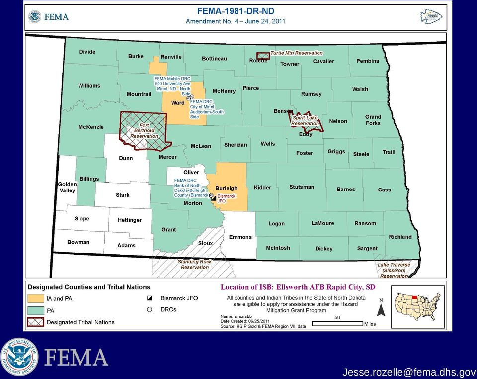
1 Rapid Damage Assessment Methodology for Catastrophic Souris River Flooding Minot, North Dakota Analyzing the Extent of Flooding Impacts Using Site Specific Analysis and User Generated Depth Grids Jesse Rozelle FEMA Region VIII Risk Analyst/Regional GIS Coordinator HIFLD Working Group Meeting Silver Springs, MD.

2 Souris (Mouse) River Geographical Context Headwaters in Southeastern Saskatchewan, Canada. Water controlled by the Alameda Rafferty Dam project. Water flows southeast into North Dakota, water controlled by the Lake Darling Dam. Approximately 20 miles southeast of Lake Darling is the city of Minot, North Dakota (2010 pop.- 40,888) Water flows southeast for roughly another 20 miles and then flows in a northeast direction into southwestern Manitoba, Canada 700km (435mi) in length and drains an area of 61,100km2 (23,600mi2).

3 2011 Flood Event Overview Physical influence behind Souris (Mouse) River flooding: Historic snowpack within Souris River Basin and surrounding drainages. Rapid spring snowmelt Heavily saturated soils Reservoirs at full capacity Multiple severe rainfall events Souris (Mouse) River: Dam Controlled Seasonal Average Flow ~200 to 2,000cfs 100yr floodplain = 5,000cfs 2011 Flooding Event Peak Flow Recorded June 26th ~ 24,000cfs
 River: Dam Controlled Seasonal Average Flow ~200 to 2,000cfs 100yr floodplain = 5,000cfs")

4 Lake Darling Anticipated Inflow/Outflow

5 2011 Flood Event Overview

6
7 -1wk nt i US GS nu nd at io n Su m rv Fl od ey oo el -F in d al g l C B US re ac st GS k Le 1, RT ve 56 Ke 1 Pr G. Pi 8 P ot S S ct ec Su om u tio rv n et n da ey ry -D y Ob a Ju ily liq ne ue Up Pi Im da 26 ct a t e th ge om s r y et Ac ry Im qu pr ag od is ec iti u at ct on s Da a m ag vail Co ab e As le nt in s es ue sm d Su en pp ts or Co tf m or pl IA et ed an Re d PA si de In nt sp s ec Re tio tu ns rn Pr eev e Minot Flood Information Timeline -1day 0 +2days 1week 2weeks +3 weeks Flooding/Mandatory Evacuations June 22nd to July 10th

8

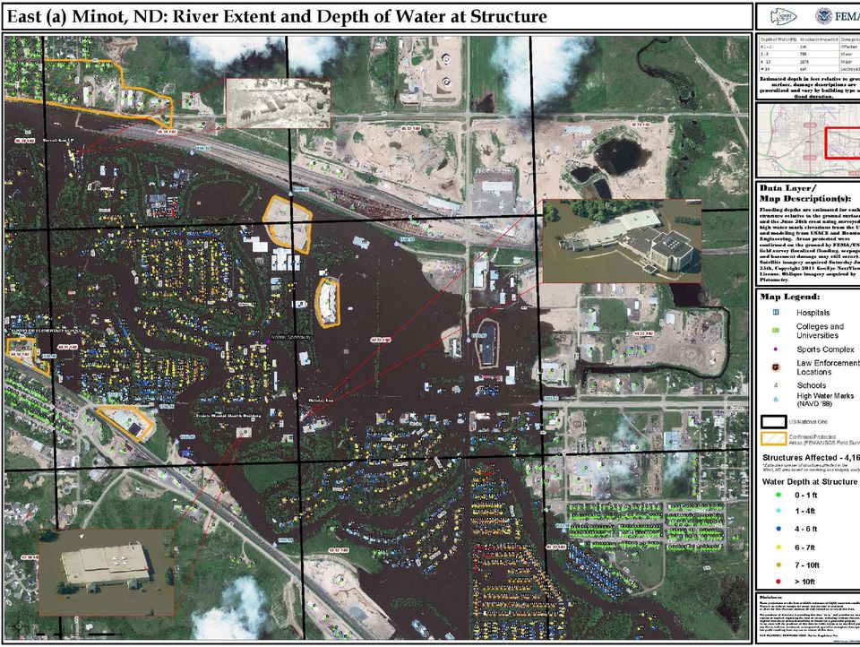
9 Task 1: USGS HWM MA Utilized RTK GPS to provide daily measurements of water surface +/- 0.1 accuracy Ground-truthed pre event lidar-based inundation modeling rather than creating IDW-depth grid from scratch Small expert USGS field team deployed from MT and WI working with ND office $26,000 total MA costs or $6 per damaged structure to provide accurate water depths at each structure relative to ground surface

10 Task 2: Oblique Imagery Contracted through USGS Rolla Mission Assignment High res (6 inch-5 way) product with pre-event available Ability to measure depth of water relative to finished floor Shared with community through a public website (minot.skygone.net) Not available for response but excellent to ongoing inspection validation $35,000 or $8.50 per impacted structure
 Not available for response but excellent to ongoing inspection validation $35,000 or $8.")
11 Task 3: Imagery Exploitation Contract with ImageCat Engaged Catastrophe Assessment Network (CAN) analysts in academia and outside U.S. Completed in 3 days over July 4th weekend Joined assessments with parcel and IA data Completed detailed assessment of large loss structures (schools, significant facilities) $35,000 or $17 per impacted structure assessed
")
12 Rapid Turnaround Damage Assessment Rapid turnaround Damage Assessment needed Damage Assessment Accomplished using the following: Coordination with USGS to collect perishable data (high water mark collection). Pictometry Oblique Arial Imagery New Light/ImageCAT Damage Assesment Digital Globe Satellite Imagery Houston Engineering FEMA Region VIII Risk Analysis Team Near Real Time Results: Number of structures impacted by flood event Approximate depth of water at each impacted structure HAZUS site specific derived financial impacts Established an SOP(Standard Operating Procedure) for rapid turnaround Damage Assessments.

13 Rapid Turnaround Damage Assessment USGS High Water Mark Collection Preliminary inundation maps were produced for anticipated peak flows and sent into the field USGS captured locations (using Real Time Kinematic (RTK) GPS techniques) of the temporary levees and high water marks used to calibrate inundation depth model.

14 Rapid Turnaround Damage Assessment Pictometry Oblique Arial Imagery Captures 5 angles of oblique imagery, including orthophotos Assisted in obtaining structure attributes required for HAZUS financial loss estimation

15 Rapid Turnaround Damage Assessment ImageCat New Light Technologies Assisted in flood exposure development Determined occupancy types of structures in flooded area Residential basement identification as well as number of stories Flood depth protocols Identified priority areas for response Rapid online product development to support widespread interpretation

16 Rapid Turnaround Damage Assessment ImageCat New Light Technologies

17

18

19
20 Rapid Turnaround Damage Assessment
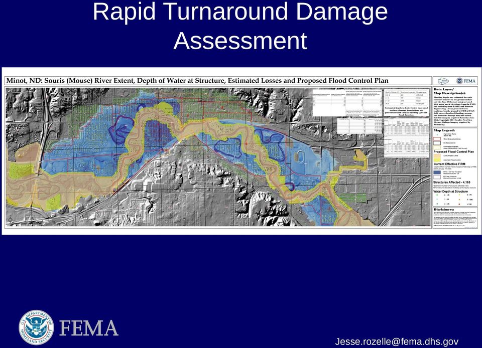
21 Rapid Turnaround Damage Assessment
22 Interagency Coordination/Collaboration USGS: Perishable Data Collection (High water marks) City of Minot: Pre-event Data LiDAR Pictometry Parcel Data Pictometry: Oblique Aerial Imagery New Light / ImageCAT: Damage Assessment Data Digital Globe satellite imagery Houston engineering: Depth Grid development NOAA: Stream Gauge Monitoring
23 Pre Event Data Collection Most critical component to Rapid Turnaround Damage Assessment Coordination with community Coordination with private sector Coordination with Federal, State, Local, and Tribal partners Rapid evaluation of population and building exposure to flood event Publically published maps gave displaced citizens a opportunity to understand the flooding situation
24 Questions? Jesse Rozelle
1.- L a m e j o r o p c ió n e s c l o na r e l d i s co ( s e e x p li c a r á d es p u é s ).
.") PROCEDIMIENTO DE RECUPERACION Y COPIAS DE SEGURIDAD DEL CORTAFUEGOS LINUX P ar a p od e r re c u p e ra r nu e s t r o c o rt a f u e go s an t e un d es a s t r e ( r ot u r a d e l di s c o o d e l a
PROCEDIMIENTO DE RECUPERACION Y COPIAS DE SEGURIDAD DEL CORTAFUEGOS LINUX P ar a p od e r re c u p e ra r nu e s t r o c o rt a f u e go s an t e un d es a s t r e ( r ot u r a d e l di s c o o d e l a
MANITOBA FLOOD PROTECTION PROJECTS Project Justification and Benefits. Science Imagination Collaboration
 MANITOBA FLOOD PROTECTION PROJECTS Project Justification and Benefits Science Imagination Collaboration Presentation Outline Extreme events on Red and Assiniboine Manitoba Flood Protection Works KGS Group
The AIR Inland Flood Model for the United States In Spring 2011, heavy rainfall and snowmelt produced massive flooding along the Mississippi River,
 The AIR Inland Flood Model for the United States In Spring 2011, heavy rainfall and snowmelt produced massive flooding along the Mississippi River, inundating huge swaths of land across seven states. As
Back Home Again in Indiana
 Back Home Again in Indiana FEMA REGION VI HAZUS LEVEL 2 PILOT Update August 2010 RAMPP (Risk Assessment, Mapping and Planning Partners) James R. Mawby, CFM - Lead Geographer, Dewberry Joseph C. Kirby,
I n la n d N a v ig a t io n a co n t r ib u t io n t o eco n o m y su st a i n a b i l i t y
 I n la n d N a v ig a t io n a co n t r ib u t io n t o eco n o m y su st a i n a b i l i t y and KB rl iak s iol mi a, hme t a ro cp hm a5 a 2k p0r0o 9f i,e ls hv oa nr t ds eu rmv oedye l o nf dae cr
Adoption of Flood Insurance Rate Maps by Participating Communities. FEMA 495 / September 2012
 Adoption of Flood Insurance Rate Maps by Participating Communities FEMA 495 / September 2012 Adoption of Flood Insurance Rate Maps by Participating Communities 1 Adoption of Flood Insurance Rate Maps by
Campus Sustainability Assessment and Related Literature
 Campus Sustainability Assessment and Related Literature An Annotated Bibliography and Resource Guide Andrew Nixon February 2002 Campus Sustainability Assessment Review Project Telephone: (616) 387-5626
Minnesota State Plan Review Level 2 Hazus-MH 2.1 County Model for Flooding Dakota County Evaluation
 Overview Minnesota State Plan Review Level 2 Hazus-MH 2.1 County Model for Flooding Dakota County Evaluation Minnesota Homeland Security and Emergency Management (HSEM) is responsible for supporting activities
H ig h L e v e l O v e r v iew. S te p h a n M a rt in. S e n io r S y s te m A rc h i te ct
 H ig h L e v e l O v e r v iew S te p h a n M a rt in S e n io r S y s te m A rc h i te ct OPEN XCHANGE Architecture Overview A ge nda D es ig n G o als A rc h i te ct u re O ve rv i ew S c a l a b ili
URBAN DRAINAGE CRITERIA
 URBAN DRAINAGE CRITERIA I. Introduction This division contains guidelines for drainage system design and establishes a policy for recognized and established engineering design of storm drain facilities
 First A S E M R e c to rs C o n f e re n c e : A sia E u ro p e H ig h e r E d u c a tio n L e a d e rsh ip D ia l o g u e Fre ie U n iv e rsitä t, B e rl in O c to b e r 2 7-2 9 2 0 0 8 G p A G e e a
National Weather Service Flash Flood Modeling and Warning Services
 National Weather Service Flash Flood Modeling and Warning Services Seann Reed, Middle Atlantic River Forecast Center Peter Ahnert, Middle Atlantic River Forecast Center August 23, 2012 USACE Flood Risk
NWS Flood Inundation Mapping Program
 NWS Flood Inundation Mapping Program Carson River Floodplain Management Forum April 22, 2015 Mark Faucette, Senior Forecaster Hydrology Program Manager NOAA/NWS, WFO Reno, NV NWS Hydrologic Services Program
This paper provides a concise description of
 13 UNIVERSITIES COUNCIL ON WATER RESOURCES ISSUE 130, PAGES 13-19, MARCH 2005 Overview of Flood Damages Prevented by U.S. Army Corps of Engineers Flood Control Reduction Programs and Activities James J.
STORMWATER POLLUTION PREVENTION PLAN TEMPLATE. 1.0 SITE DESCRIPTION 1.1 Project Name and Location Date
 STORMWATER POLLUTION PREVENTION PLAN TEMPLATE Disclaimer: This template was developed for guidance purposes only in an effort to assist Construction Storm Water permit applicants in meeting state and local
Water Security Agency. Plan for 2015-16. saskatchewan.ca
 Water Security Agency Plan for 2015-16 saskatchewan.ca Statement from the Minister I am pleased to present the Water Security Agency s Plan for 2015-16. The Honourable Scott Moe Minister Responsible for
Flood Emergency Response Planning: How to Protect Your Business from a Natural Disaster RIC005
 Flood Emergency Response Planning: How to Protect Your Business from a Natural Disaster RIC005 Speakers: Tom Chan, CEO, Global Risk Miyamoto Greg Bates, Principal, Global Risk Consultants Learning Objectives
Presented by: Michael DePue, PE, CFM Annual Georgia Association of Floodplain Management Conference Lake Lanier Islands, Georgia March 23, 2010
 Flood Types and Characteristics Presented by: Michael DePue, PE, CFM Annual Georgia Association of Floodplain Management Conference Lake Lanier Islands, Georgia March 23, 2010 Agenda Why study flood types?
Dam Risk Reduction Case Study. Background Nashville and Davidson County, Tennessee, the population hub of Middle
 Dam Risk Reduction Case Study [NASHVILLE, TENNESSEE MAY 2010 FLOODING] Background Nashville and Davidson County, Tennessee, the population hub of Middle Tennessee with a combined population of over 635,000,
Basement Flood Risk Reduction City of Winnipeg. Charles Boulet
 Basement Flood Risk Reduction City of Winnipeg Charles Boulet Outline Background Winnipeg Floodway Rain Events Winnipeg Sewer System Basement Flooding Flood Reduction Measures ICLR - BFRR Strategy 2 Where
Where is Risk MAP Now? Update on the Flood Risk Assessment Dataset. Shane Parson RAMPP
 Where is Risk MAP Now? Update on the Flood Risk Assessment Dataset Shane Parson RAMPP Agenda Overview Average Annualized Loss (AAL Study) Risk MAP Flood Risk Assessment Dataset Process AAL Data Refined
The Basics of Chapter 105 Waterways and Wetlands Permitting in PA
 The Basics of Chapter 105 Waterways and Wetlands Permitting in PA April 17, 2013 Goal To develop a basic understanding of PA Department of Environmental Protection (DEP) and US Army Corps of Engineers
Development of Technical Data For Long Term Flood Solutions For the Red River Basin
 IDENTIFYING WHAT WE DIDN T KNOW Development of Technical Data For Long Term Flood Solutions For the Red River Basin LTFS Study Area U.S. Portion of Red River Basin (MN, ND & SD) Main Stem Red River Tributaries
i n g S e c u r it y 3 1B# ; u r w e b a p p li c a tio n s f r o m ha c ke r s w ith t his å ] í d : L : g u id e Scanned by CamScanner
![i n g S e c u r it y 3 1B# ; u r w e b a p p li c a tio n s f r o m ha c ke r s w ith t his å ] í d : L : g u id e Scanned by CamScanner](/thumbs/24/2864992.jpg "i n g S e c u r it y 3 1B# ; u r w e b a p p li c a tio n s f r o m ha c ke r s w ith t his å ] í d : L : g u id e Scanned by CamScanner") í d : r ' " B o m m 1 E x p e r i e n c e L : i i n g S e c u r it y. 1-1B# ; u r w e b a p p li c a tio n s f r o m ha c ke r s w ith t his g u id e å ] - ew i c h P e t e r M u la e n PACKT ' TAÞ$Æo
í d : r ' " B o m m 1 E x p e r i e n c e L : i i n g S e c u r it y. 1-1B# ; u r w e b a p p li c a tio n s f r o m ha c ke r s w ith t his g u id e å ] - ew i c h P e t e r M u la e n PACKT ' TAÞ$Æo
Global Flood Alert System (GFAS)
") An Introduction of Global Flood Alert System (GFAS) Kazuo UMEDA Director of 2 nd Research Department, Infrastructure Development Institute-JAPAN Target: Reduction of Human Loss World s s natural disaster
An Introduction of Global Flood Alert System (GFAS) Kazuo UMEDA Director of 2 nd Research Department, Infrastructure Development Institute-JAPAN Target: Reduction of Human Loss World s s natural disaster
FLOOD FORECASTING PRACTICE IN NORTHERN CALIFORNIA
 FLOOD FORECASTING PRACTICE IN NORTHERN CALIFORNIA California Department of Water Resources Post Office Box 219000, Sacramento, California 95821 9000 USA By Maurice Roos, Chief Hydrologist ABSTRACT Although
A Flood Warning System for City of Findlay, Ohio
 A Flood Warning System for City of Findlay, Ohio Matt Whitehead US Geological Survey, Ohio Water Science Center 6480 Doubletree Avenue Columbus, Ohio 43229 Abstract The U.S. Geological Survey (USGS) and
Burnt River Black River and Gull River Flood Contingency Plan
 Burnt River Black River and Gull River Flood Contingency Plan Objective: The objective of this plan is to preplan and prepare for flooding events in the Burnt River, Black River and Gull River area of
Structural Damage Due to Floods
 Structural Damage Due to Floods By Craig D. Rogers, P.E. The Federal Emergency Management Agency (FEMA) reports that each year approximately 90 percent of all disaster-related property damage results from
SCO TT G LEA SO N D EM O Z G EB R E-
 SCO TT G LEA SO N D EM O Z G EB R E- EG Z IA B H ER e d it o r s N ) LICA TIO N S A N D M ETH O D S t DVD N CLUDED C o n t e n Ls Pr e fa c e x v G l o b a l N a v i g a t i o n Sa t e llit e S y s t e
Guidance for Flood Risk Analysis and Mapping. Changes Since Last FIRM
 Guidance for Flood Risk Analysis and Mapping Changes Since Last FIRM May 2014 This guidance document supports effective and efficient implementation of flood risk analysis and mapping standards codified
Probability Magnitude/Severity Warning Time Duration CPRI Flood 3.25 2.88 2.50 3.13 3.01
 3.7.8 FLOOD Probability Magnitude/Severity Warning Time Duration CPRI Flood 3.25 2.88 2.50 3.13 3.01 Description Flooding is the most frequent and costly natural hazard in the United States. During the
CRS 610 Ventura County Flood Warning System Website
 CRS 610 Ventura County Flood Warning System Website Purpose This document gives instructions and a description of the information available via the Ventura County Watershed Protection District s (VCWPD)
BMC ITSM Suite - nabité skúsenosťami. Juraj Izák, 13.10.2011
 BMC ITSM Suite - nabité skúsenosťami Juraj Izák, 13.10.2011 MATERNA GmbH 2011 www.materna.com 1 Presenter Name Function E-mail Telephone Fax Mobile Ing. Juraj Izák Senior Consultant [email protected]
Remote Sensing: Correlating Satellite Images with In-field Observations for Advanced Damage Detection
 Remote Sensing: Correlating Satellite Images with In-field Observations for Advanced Damage Detection ImageCat, Inc. Shubharoop Ghosh Beverley J. Adams, Ph.D. ImageCat, Inc. J. Arn Womble, P.E. Texas Tech
GIS MAPPING FOR IRRIGATION DISTRICT RAPID APPRAISALS Daniel J. Howes 1, Charles M. Burt 2, Stuart W. Styles 3 ABSTRACT
 GIS MAPPING FOR IRRIGATION DISTRICT RAPID APPRAISALS Daniel J. Howes 1, Charles M. Burt 2, Stuart W. Styles 3 ABSTRACT Geographic information system (GIS) mapping is slowly becoming commonplace in irrigation
MAPPING MINNEAPOLIS URBAN TREE CANOPY. Why is Tree Canopy Important? Project Background. Mapping Minneapolis Urban Tree Canopy.
 MAPPING MINNEAPOLIS URBAN TREE CANOPY Why is Tree Canopy Important? Trees are an important component of urban environments. In addition to their aesthetic value, trees have significant economic and environmental
Storm tide is the water level rise during a storm due to the combination of storm surge and the astronomical tide.
 INTRODUCTION TO STORM SURGE Introduction to Storm Surge BOLIVAR PENINSULA IN TEXAS AFTER HURRICANE IKE (2008) What is Storm Surge? Inland Extent Storm surge can penetrate well inland from the coastline.
Integrated Water Resources Science and Services. National Water Center
 TOO MUCH POOR QUALITY TOO LITTLE Integrated Water Resources Science and Services and the National Water Center Partnering to Address America s Water Resources Information Needs Mary G. Mullusky National
Community RiskMAP Questionnaire
 Community RiskMAP Questionnaire Please provide the following information County Date: Community Name/Organization: Your Your E-mail: Contact Preference: E-mail Phone Mail The Federal Emergency Management
Flood Risk Management
 Flood Risk Management Value of Flood Risk Management Every year floods sweep through communities across the United States taking lives, destroying property, shutting down businesses, harming the environment
Flood Risk Management
 Flood Risk Management Value of Flood Risk Management Value to Individuals and Communities Every year floods sweep through communities across the United States taking lives, destroying property, shutting
TENNESSEE GAS PIPELINE COMPANY, L.L.C.
 TENNESSEE GAS PIPELINE COMPANY, L.L.C. HYDROLOGIC & HYDRAULIC CALCULATIONS FOR WATERBODIES CROSSED BY CONNECTICUT PIPELINE EXPANSION PROJECT CONNECTICUT LOOP Submitted by: Tennessee Gas Pipeline Company,
How To Rate Plan On A Credit Card With A Credit Union
 Rate History Contact: 1 (800) 331-1538 Form * ** Date Date Name 1 NH94 I D 9/14/1998 N/A N/A N/A 35.00% 20.00% 1/25/2006 3/27/2006 8/20/2006 2 LTC94P I F 9/14/1998 N/A N/A N/A 35.00% 20.00% 1/25/2006 3/27/2006
Storm tide is the water level rise during a storm due to the combination of storm surge and the astronomical tide.
 INTRODUCTION TO STORM SURGE Introduction to Storm Surge National Hurricane Center Storm Surge Unit BOLIVAR PENINSULA IN TEXAS AFTER HURRICANE IKE (2008) What is Storm Surge? Inland Extent Storm surge can
 PRIMER TESTIMONIO. -F o l i o n ú m e r o 1 2 0. ḋḋḋḋḋḋḋḋḋḋḋḋḋḋḋḋḋḋḋḋḋḋḋḋḋḋḋḋḋḋḋḋḋḋḋḋḋ ESC RITU RA NU MERO TREINTA.- E n l a c i u d a d d e B u e n os A i r e s, c a p i t a l d e l a R e p ú b l i c
NEW CARRIER SIGN UP REQUEST FORM
 Instructions: (Please fax or email the completed documents) [email protected] Fax: 1-855-631-4174 o Fill o Copy o Copy o initial o Insurance out Carrier profile of Common Carrier Authority Company
NHIS State Health insurance data
 State Estimates of Health Insurance Coverage Data from the National Health Interview Survey Eve Powell-Griner SHADAC State Survey Workshop Washington, DC, January 13, 2009 U.S. DEPARTMENT OF HEALTH AND
Preapproval Inspections for Manufacturing. Christy Foreman Deputy Director Division of Enforcement B Office of Compliance/CDRH
 Preapproval Inspections for Manufacturing Christy Foreman Deputy Director Division of Enforcement B Office of Compliance/CDRH Major Steps Review of the Quality System information Inspection requests generated
Aneeqa Syed [Hatfield Consultants] Vancouver GIS Users Group Meeting December 8, 2010
![Aneeqa Syed [Hatfield Consultants] Vancouver GIS Users Group Meeting December 8, 2010](/thumbs/27/11179985.jpg "Aneeqa Syed [Hatfield Consultants] Vancouver GIS Users Group Meeting December 8, 2010") NEAR-REAL-TIME FLOOD MAPPING AND MONITORING SERVICE Aneeqa Syed [Hatfield Consultants] Vancouver GIS Users Group Meeting December 8, 2010 SLIDE 1 MRC Flood Service Project Partners and Client Hatfield
NEAR-REAL-TIME FLOOD MAPPING AND MONITORING SERVICE Aneeqa Syed [Hatfield Consultants] Vancouver GIS Users Group Meeting December 8, 2010 SLIDE 1 MRC Flood Service Project Partners and Client Hatfield
 C o a t i a n P u b l i c D e b tm a n a g e m e n t a n d C h a l l e n g e s o f M a k e t D e v e l o p m e n t Z a g e bo 8 t h A p i l 2 0 1 1 h t t pdd w w wp i j fp h D p u b l i c2 d e b td S t
Brief Analysis of Flooding in Minnesota
 Brief Analysis of Flooding in Minnesota Recent Flood Events, Statewide Flood Risk Assessment, and Hazard Mitigation Prepared by: Al Kean, Chief Engineer Minnesota Board of Water and Soil Resources In Consultation
 G ri d m on i tori n g w i th N A G I O S (*) (*) Work in collaboration with P. Lo Re, G. S av a and G. T ortone WP3-I CHEP 2000, N F N 10.02.2000 M e e t i n g, N a p l e s, 29.1 1.20 0 2 R o b e r 1
City of Salinas Flood Response Preparations
 City of Salinas Flood Response Preparations Winter Preparations Goals for 2015/2016 Community Preparedness in the event of flooding Media cooperation on safety and preparedness, public information sharing
FINAL TECHNICAL MEMORANDUM AWD-00002 FLOWS THROUGH FLOOD DAMAGE REDUCTION AREA July 16, 2012
 FINAL TECHNICAL MEMORANDUM AWD-00002 FLOWS THROUGH FLOOD DAMAGE REDUCTION AREA July 16, 2012 Table of Contents TABLE OF CONTENTS Table of Contents... 1 Executive Summary... 2 1 Objective... 4 2 Study Approach...
UNION COUNTY, FLORIDA AND INCORPORATED AREAS
 UNION COUNTY, FLORIDA AND INCORPORATED AREAS COMMUNITY NAME COMMUNITY NUMBER LAKE BUTLER, CITY OF 120595 RAIFORD, TOWN OF 120593 UNION COUNTY 120422 (UNINCORPORATED AREAS) WORTHINGTON SPRINGS, CITY OF
Rainfall Intensities for Southeastern Arizona
 Rainfall Intensities for Southeastern Arizona By Herbert B. Osborn, Member, ASCE1 and Kenneth G. Renard, Fellow, ASCE1 Introduction Small watershed storm runoff in the southwestern United States is dominated
Innovative Approaches in Flood Damage Reduction
 Innovative Approaches in Flood Damage Reduction Solutions for the Stormwater Management High Level Results 3D geospatial model of storm water management pond (GRCA, 2013) Enhanced understanding of storm
GTM North Carolina Floodplain Mapping Program. RFQ 286-000023 Pre-Submittal Conference
 GTM North Carolina Floodplain Mapping Program RFQ 286-000023 Pre-Submittal Conference State Response / Strategies Strategy 1 - Establishment of a statewide program to acquire, process and disseminate current,
HCP Team Meeting. November 18, 2015. icfi.com
 HCP Team Meeting November 18, 2015 icfi.com 1 Welcome and Introductions Where are we in the HCP process Hydrology modeling update Native fish survey Fish translocation Finalize covered activities Next
Stream Channel Cross Sections for a Reach of the Boise River in Ada County, Idaho
 U.S. Department of the Interior U.S. Geological Survey In cooperation with Federal Emergency Management Agency, City of Boise, City of Garden City, City of Eagle, and Ada County Stream Channel Cross Sections
Fort Dodge Stormwater Master Planning. Prepared By: Ralph C. Stark, Jr., P.E., C.F.M. Joel N. Krause, P.E., C.F.M.
 Fort Dodge Stormwater Master Planning Prepared By: Ralph C. Stark, Jr., P.E., C.F.M. Joel N. Krause, P.E., C.F.M. Project Location Project Background Flooding History Localized flooding and storm sewer
THE FIELD PROGRAM: SERVING NEMA MEMBERS AND PROMOTING PUBLIC SAFETY
 THE FIELD PROGRAM: SERVING NEMA MEMBERS AND PROMOTING PUBLIC SAFETY Program Mission NEMA s field representative program serves NEMA members by promoting the use and adoption of the National Electrical
Hydrologic Engineering Techniques for Regional Water Resources Planning
 US Army Corps of Engineers Hydrologic Engineering Center Hydrologic Engineering Techniques for Regional Water Resources Planning October 1969 Approved for Public Release. Distribution Unlimited. TP-17
Using probability to understand 100-year storms
 1 + Using probability to understand 100-year storms Grade Level: 5-7 Activity Duration: 30-45 minutes Overview: I. Storm stories II. 100-year Storm Probability III. Delineating Storms in NE Minnesota Summary:
Methods for Determination of Safe Yield and Compensation Water from Storage Reservoirs
 US Army Corps of Engineers Hydrologic Engineering Center Methods for Determination of Safe Yield and Compensation Water from Storage Reservoirs October 1966 Approved for Public Release. Distribution Unlimited.
Breakeven Cost for Residential Photovoltaics in the United States: Key Drivers and Sensitivities (Report Summary)
") Breakeven Cost for Residential Photovoltaics in the United States: Key Drivers and Sensitivities (Report Summary) Paul Denholm Robert M. Margolis Sean Ong Billy Roberts December 2009 NREL/PR-6A2-47248
Breakeven Cost for Residential Photovoltaics in the United States: Key Drivers and Sensitivities (Report Summary) Paul Denholm Robert M. Margolis Sean Ong Billy Roberts December 2009 NREL/PR-6A2-47248
The City of Ottawa Flood Hazards
 The City of Ottawa Flood Hazards The City of Ottawa is located in North Central LaSalle County, approximately 45 miles West of Joliet and 90 miles South of Rockford. The primary water course and sources
Flooding in the Middle Koyukuk River Basin, Alaska August 1994
 Flooding in the Middle Koyukuk River Basin, Alaska August 1994 By David F. Meyer U.S. GEOLOGICAL SURVEY Water-Resources Investigations Report 95-4118 Prepared in cooperation with the FEDERAL EMERGENCY
Digital Orthophoto Production In the Desktop Environment 1
 Digital Orthophoto Production In the Desktop Environment 1 By Dr. Roy A. Welch and Thomas R. Jordan Digital orthophotos are proving suitable for a variety of mapping, GIS and environmental monitoring tasks.
Components of a Basement Flooding Protection Plan: Sewer System Improvements. November 2000
 Components of a Basement Flooding Protection Plan: Sewer System Improvements November 2000 Components of a Basement Flooding Protection Plan: Sewer System Improvements November 2000 SEMCOG 2000 Prepared
PROGRAM HIGHLIGHTS. Association of Collegiate Schools of Architecture 2011-12 ACSA100. Visit ACSA100.org to make your donation.
 ACSA100 In 2012, ACSA will celebrate 100 years of advancing critical issues facing architectural education. The organization has planned four major projects surrounding the centennial: an engaging scholarly
River Flood Damage Assessment using IKONOS images, Segmentation Algorithms & Flood Simulation Models
 River Flood Damage Assessment using IKONOS images, Segmentation Algorithms & Flood Simulation Models Steven M. de Jong & Raymond Sluiter Utrecht University Corné van der Sande Netherlands Earth Observation
1. Oblast rozvoj spolků a SU UK 1.1. Zvyšování kvalifikace Školení Zapojení do projektů Poradenství 1.2. Financování 1.2.1.
 1. O b l a s t r o z v o j s p o l k a S U U K 1. 1. Z v y š o v á n í k v a l i f i k a c e Š k o l e n í o S t u d e n t s k á u n i e U n i v e r z i t y K a r l o v y ( d á l e j e n S U U K ) z í
Quality Assurance Reviews of Hydraulic Models Developed for the Central Valley Floodplain Evaluation and Delineation Program
 Quality Assurance Reviews of Hydraulic Models Developed for the Central Valley Floodplain Evaluation and Delineation Program Techniques Applied and Lessons Learned Seth Ahrens, P.E., CFM Selena Forman,
Flood Zone Investigation by using Satellite and Aerial Imagery
 Flood Zone Investigation by using Satellite and Aerial Imagery Younes Daneshbod Islamic Azad University-Arsanjan branch Daneshgah Boulevard, Islamid Azad University, Arsnjan, Iran Email: [email protected]
Flood Guide lcra.org
 COLORADO RIVER Flood Guide lcra.org Be prepared for weather and flood emergencies If you live along the Highland Lakes, the lower Colorado River or its tributaries, it s critically important to be prepared
CIS CO S Y S T E M S. G u ille rm o A g u irre, Cis c o Ch ile. 2 0 0 1, C is c o S y s te m s, In c. A ll rig h ts re s e rv e d.
 CIS CO S Y S T E M S A c c e s s T e c h n o lo g y T e le c o m /IT Co n n e c tiv ity W o rk s h o p G u ille rm o A g u irre, Cis c o Ch ile g m o.a g u irre @ c is c o.c o m S e s s io n N u m b e
Westerly Creek, A Poster Child for Understanding the Benefit of Stormwater Investment
 Westerly Creek, A Poster Child for Understanding the Benefit of Stormwater Investment Presented at the ASFPM Annual Conference Atlanta, GA June 1 June 5 2015 Jon Villines, EIT, CFM Aurora Water Alan Turner,
Red River Basin Flood Damage Reduction Framework
 Red River Basin Flood Damage Reduction Framework Red River Basin Flood Damage Reduction Work Group Technical and Scientific Advisory Committee Technical Paper No. 11 Principal Authors: Charles Anderson,
3.4 DRAINAGE PLAN. 3.4.1 Characteristics of Existing Drainages. 3.4.2 Master Drainage System. Section 3: Development Plan BUTTERFIELD SPECIFIC PLAN
 3.4 DRAINAGE PLAN This section describes the existing onsite drainage characteristics and improvements proposed within this Specific Plan. Following this description, drainage plan development standards
Section 6 Benefit-Cost Analysis
 6.1 Introduction For the preferred storage alternatives, a benefit-cost analysis (BCA) was conducted to evaluate the economic feasibility of implementation. The economic evaluation was conducted using
Regional Electricity Forecasting
 Regional Electricity Forecasting presented to Michigan Forum on Economic Regulatory Policy January 29, 2010 presented by Doug Gotham State Utility Forecasting Group State Utility Forecasting Group Began
HAZUS 2014. 7 th Annual Conference
 HAZUS 2014 7 th Annual Conference HAZUS Comparison of Storm Surge Levels from Different Hurricanes to the Newest SLOSH Models for Berkeley, Charleston, & Dorchester Counties Along the SC Coastline. Charlie
Flood Mitigation Workgroup Final Findings and Recommendations Part 1 Immediate Needs and Short-Term Plan. June 4, 2015
 Flood Mitigation Workgroup Final Findings and Recommendations Part 1 Immediate Needs and Short-Term Plan June 4, 2015 Background: On April 3, 2015, Louisville Metro experienced a significant rainstorm
U.S. Department of Housing and Urban Development: Weekly Progress Report on Recovery Act Spending
 U.S. Department of Housing and Urban Development: Weekly Progress Report on Recovery Act Spending by State and Program Report as of 3/7/2011 5:40:51 PM HUD's Weekly Recovery Act Progress Report: AK Grants