Quality Assurance Reviews of Hydraulic Models Developed for the Central Valley Floodplain Evaluation and Delineation Program
|
|
|
- Gerald West
- 9 years ago
- Views:
Transcription
1 Quality Assurance Reviews of Hydraulic Models Developed for the Central Valley Floodplain Evaluation and Delineation Program Techniques Applied and Lessons Learned Seth Ahrens, P.E., CFM Selena Forman, Ph.D., P.E. ASFPM Conference June 3,

2 Outline Overview of the California Department of Water Resources (DWR) Central Valley Floodplain Evaluation and Delineation (CVFED) program Development of the modeling and quality management criteria The quality assurance (QA) review process Custom tools developed by Atkins to facilitate the QA reviews Lessons learned 2

3 A Little Bit About Me Sacramento, CA Part of Atkins team supporting DWR QA reviewer of CVFED hydraulic modeling (mostly FLO-2D) Project manager for California Levee Database development Project manager for population of DWR s Library of Models Central role in the development of 6,700 miles of Awareness Floodplain Mapping 2015-Present Oakland, CA STARR II Region Service Center lead for FEMA Region IX 3

4 Overview of the CVFED Program Initiated by DWR in 2008 Develop foundational datasets, models, and tools associated with the State Plan of Flood Control to support State s flood management programs and projects Improve quality and accuracy of flood hazard data to help communities comply with recent legislative mandates in CA Develop new hydraulic models acceptable to FEMA and USACE Provide information to support future planning and project design 4

5 Overview of the CVFED Program Hydraulic evaluation of the Sacramento River system and the San Joaquin River system in the Central Valley Major products: 9,000 mi 2 of aerial photography 7,800 mi 2 of topographic data (LiDAR) 1,650 miles of 1-D modeling (HEC-RAS) 5,950 mi 2 of 2-D modeling (mostly FLO-2D, some TUFLOW) Field survey and bathymetric survey (5,500 cross sections total) 5
 Field survey and bathymetric survey (5,500 cross sections")


6 Overview of the CVFED Program Hydraulic Model Development DWR Program Mgmt. Quality Assurance USACE Quality Assurance CH2M North Sac River Basin Wood Rodgers South Sac River Basin HDR North SJ River Basin RBF South SJ River Basin 6

7 Thinking About Quality Management CVFED hydraulic models are large and complex Many models needed to be created and reviewed in a short time frame Desirable to standardize model development across AEC teams Desirable to have an organized review process Tools can be useful for flagging potential problem areas that may require in-depth review These tools enhance review efficiency and quality Today s talk will focus on FLO-2D 7

8 Development of the Quality Management Criteria Hydrology and Hydraulics Coordination Work Group (HHCWG) was created early in process Standardized approaches and techniques to be applied by the AEC modeling teams Established review processes to be followed by AEC teams (QC), Atkins (QA), and USACE (QA) 8
, Atkins (QA),")
9 HHCWG FLO-2D Guideline Documents ARF/WRF Infiltration Model Documentation Depth Variable Roughness Initial n Values Overland Structures Embankments Limiting Froude Number Overlap Standards 9

10 The Quality Assurance Review Process Organized using CVFED hydraulic QA review spreadsheets Unique review spreadsheet for each model type HEC-RAS FLO-2D TUFLOW FLO-2D: 78 questions grouped into 9 topics Other model types similar 10

11 The Quality Assurance Review Process The FLO-2D QA review spreadsheet included 78 questions grouped into 9 topics Model Grid Channel Flow Street Features Boundary Conditions Overland Flow Manning s n Levees and Levee- Like Features Hydraulic Structures Area Modification/Flow Obstruction Calculations and Results 11

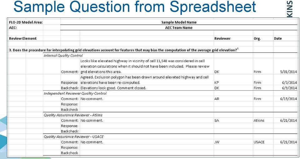
12 Sample Question from Spreadsheet 12
13 1-Dimensional Unsteady HEC-RAS QA Review Tools Developed tools to read the geometry file and model output to check the following and flag areas for more detailed review: Confirm stream centerline length corresponded to cross section stationing Compare lateral weir and storage area connection elevations with topography Check that user-specified lateral weir lengths corresponded to GIS layer Check storage area volume-elevation curves against topography Check that storage area minimum elevations were below the elevations of connected lateral structures Check lateral structure connectivity to storage areas Check storage area connectivity 13

14 Other HEC-RAS Review Approaches Review low-flow and high-flow water surface profiles for critical depth solutions and jumps/discontinuities Review energy grade line profile for any anomalies Review ground profile for large changes and appropriate modeling approach Check that bank station widths and elevations varied gradually along a reach Check that the active top width and velocity varied gradually along the reach Check that the flow is stabilized at the end of the warm-up period Review output messages for warnings such as: Computed water surface elevations below storage area invert Minimum error solutions Interpolated values above computed curves Unstable solutions 14

15 FLO-2D QA Review Tools Create output shapefiles and rasters Check elevations Check n- values Check embankment elevations Embankment hunter Check channels 15

16 Create Shapefiles and Rasters Representing FLO-2D Output FLO-2D Output Text Files Shapefiles and Rasters Output shapefiles: Output rasters: Grid cell layout ARF assignments Flooding extents Floodplain depths and elevations Hydraulic conveyance structures Floodplain velocities Levee-like structures Peak discharges NOFLOCs Ground elevations Width-area reduction factors n-value assignments 16


17 Output Shapefile Example 17


18 Attribute Table of Levee Output Shapefile 18


19 Output Raster Example 19

20 Tools for Checking Cell Elevations and Manning s n-value Assignments These tools computed the ground elevation and the n- value assignment for each cell and then compared them to what was in the model Both tools worked in a similar fashion in that they intersected the grid layout with the topographic data or the n-value shapefile 20


21 Checking n-value Assignments 21

22 Checking n-value Assignments 22
23 Embankment Hunter Modeling guidelines stated that all embankments with heights greater than two to three feet were to be included in the modeling This tool looked for steep slopes in the terrain and estimated embankment heights near these slopes Useful for confirming that all tall embankments were modeled 23


24 Embankment Hunter 24
25 Tool for Checking Channel Modeling Channels can be tricky in FLO-2D Channel tool created shapefiles of the channel features Channel tool created hydrograph for each channel cell (PDF) 25

26 Channel Shapefiles 26

27 Channel Cell Attribute Table 27
28 Channel Hydrograph 28
29 Sample Applications of FLO-2D QA Review Tools Point out high flow rates over levees Confirm levee elevations at levee junctions Color-code levees to show which were overtopped Point out unstable hydrographs Confirm channel alignment, cross section layout, NOFLOCs Confirm model captured embankments Confirm model captured hydraulic structures Confirm ground elevation and n-value assignments Confirm ARF/WRF assignments 29
30 Lessons Learned Models of this size are extremely complex Taking time up front to plan will pay off later Automated processes are not foolproof Additional layers of review provide benefit Custom tools can enhance review efficiency and quality 30
31 Thank you Feel free to contact me with additional questions: (415) If you d like to find out more visit: Atkins Limited except where stated otherwise. 31
Using GIS Data With HEC-RAS
 C H A P T E R 14 Using GIS Data With HEC-RAS HEC-RAS has the ability to import three-dimensional (3D) river schematic and cross section data created in a GIS or CADD system. While the HEC- RAS software
COMPARING DSS-WISE- LITE TO OTHER DAM BREACH SOFTWARE
 National Dam Safety Program Technical Seminar No. 22 Dam Breach Modeling and Consequence Assessment National Emergency Training Center February 18-19, 2015 Emmitsburg, MD Brian Shane Cook, PE, LSIT formerly
Appendix C - Risk Assessment: Technical Details. Appendix C - Risk Assessment: Technical Details
 Appendix C - Risk Assessment: Technical Details Page C1 C1 Surface Water Modelling 1. Introduction 1.1 BACKGROUND URS Scott Wilson has constructed 13 TUFLOW hydraulic models across the London Boroughs
DEVELOPING AN INUNDATION MAP STANDARD FOR THE U.S. ARMY CORPS OF ENGINEERS
 DEVELOPING AN INUNDATION MAP STANDARD FOR THE U.S. ARMY CORPS OF ENGINEERS Will Breitkreutz, Geographer, U.S. Army Corps of Engineers Kansas City District, Kansas City, Missouri, [email protected]
2D Modeling of Urban Flood Vulnerable Areas
 2D Modeling of Urban Flood Vulnerable Areas Sameer Dhalla, P.Eng. Dilnesaw Chekol, Ph.D. A.D. Latornell Conservation Symposium November 22, 2013 Outline 1. Toronto and Region 2. Evolution of Flood Management
DANIELS RUN STREAM RESTORATION, FAIRFAX, VIRGINIA: FLOODPLAIN ANALYSIS REPORT
 DANIELS RUN STREAM RESTORATION, FAIRFAX, VIRGINIA: FLOODPLAIN ANALYSIS REPORT By: Conor C. Shea Stream Habitat Assessment and Restoration Program U.S. Fish and Wildlife Service CBFO-S07-01 Prepared in
UTILITIZATION OF ECOHYDROLOGIC MODELS IN FLOODPLAIN FISH PASSAGE AND HABITAT RESTORATION EVALUATION
 UTILITIZATION OF ECOHYDROLOGIC MODELS IN FLOODPLAIN FISH PASSAGE AND HABITAT RESTORATION EVALUATION Joshua A. Israel, Fish Biologist, U.S Bureau of Reclamation, Sacramento, CA. [email protected]; Paul
Environmental Data Management Programs
 Hydrologic Engineering Centre (HEC) Software CD Collection of programs, developed by the U.S. Army Corps of Engineers Environmental Data Management Programs Name: HEC-DSS Package Purpose: Data Storage
Appendix 4-C. Open Channel Theory
 4-C-1 Appendix 4-C Open Channel Theory 4-C-2 Appendix 4.C - Table of Contents 4.C.1 Open Channel Flow Theory 4-C-3 4.C.2 Concepts 4-C-3 4.C.2.1 Specific Energy 4-C-3 4.C.2.2 Velocity Distribution Coefficient
USSD Workshop on Dam Break Analysis Applied to Tailings Dams
 USSD Workshop on Dam Break Analysis Applied to Tailings Dams Antecedents Newtonian / non-newtonian flows Available models that allow the simulation of non- Newtonian flows (tailings) Other models used
Fort Dodge Stormwater Master Planning. Prepared By: Ralph C. Stark, Jr., P.E., C.F.M. Joel N. Krause, P.E., C.F.M.
 Fort Dodge Stormwater Master Planning Prepared By: Ralph C. Stark, Jr., P.E., C.F.M. Joel N. Krause, P.E., C.F.M. Project Location Project Background Flooding History Localized flooding and storm sewer
CHAPTER 9 CHANNELS APPENDIX A. Hydraulic Design Equations for Open Channel Flow
 CHAPTER 9 CHANNELS APPENDIX A Hydraulic Design Equations for Open Channel Flow SEPTEMBER 2009 CHAPTER 9 APPENDIX A Hydraulic Design Equations for Open Channel Flow Introduction The Equations presented
NWS Flood Inundation Mapping Program
 NWS Flood Inundation Mapping Program Carson River Floodplain Management Forum April 22, 2015 Mark Faucette, Senior Forecaster Hydrology Program Manager NOAA/NWS, WFO Reno, NV NWS Hydrologic Services Program
URBAN DRAINAGE CRITERIA
 URBAN DRAINAGE CRITERIA I. Introduction This division contains guidelines for drainage system design and establishes a policy for recognized and established engineering design of storm drain facilities
USING DETAILED 2D URBAN FLOODPLAIN MODELLING TO INFORM DEVELOPMENT PLANNING IN MISSISSAUGA, ON
 22nd Canadian Hydrotechnical Conference 22e Conférence canadienne d hydrotechnique Water for Sustainable Development : Coping with Climate and Environmental Changes L eau pour le développement durable:
What is the most obvious difference between pipe flow and open channel flow????????????? (in terms of flow conditions and energy situation)
") OPEN CHANNEL FLOW 1 3 Question What is the most obvious difference between pipe flow and open channel flow????????????? (in terms of flow conditions and energy situation) Typical open channel shapes Figure
OPEN CHANNEL FLOW 1 3 Question What is the most obvious difference between pipe flow and open channel flow????????????? (in terms of flow conditions and energy situation) Typical open channel shapes Figure
Public Draft. Attachment 8F: Flood Damage Analysis. 2012 Central Valley Flood Protection Plan. January 2012
 2012 Central Valley Flood Protection Plan Attachment 8F: Flood Damage Analysis January 2012 STATE OF CALIFORNIA THE NATURAL RESOURCES AGENCY DEPARTMENT OF WATER RESOURCES This page left blank intentionally.
FLOODPLAIN DELINEATION IN MUGLA-DALAMAN PLAIN USING GIS BASED RIVER ANALYSIS SYSTEM
 FLOODPLAIN DELINEATION IN MUGLA-DALAMAN PLAIN USING GIS BASED RIVER ANALYSIS SYSTEM Dr. Murat Ali HATİPOĞLU Fatih KESKİN Kemal SEYREK State Hydraulics Works (DSI), Investigation and Planning Department
Emergency Spillways (Sediment basins)
") Emergency Spillways (Sediment basins) DRAINAGE CONTROL TECHNIQUE Low Gradient Velocity Control Short-Term Steep Gradient Channel Lining Medium-Long Term Outlet Control Soil Treatment Permanent [1] [1]
Emergency Spillways (Sediment basins) DRAINAGE CONTROL TECHNIQUE Low Gradient Velocity Control Short-Term Steep Gradient Channel Lining Medium-Long Term Outlet Control Soil Treatment Permanent [1] [1]
ROSE CREEK WATERSHED HYDROLOGIC, HYDRAULIC, SEDIMENT TRANSPORT, AND GEOMORPHIC ANALYSES TASK 1 EXISTING DATA AND INFORMATION SUMMARY REPORT BACKGROUND
 ROSE CREEK WATERSHED HYDROLOGIC, HYDRAULIC, SEDIMENT TRANSPORT, AND GEOMORPHIC ANALYSES TASK 1 EXISTING DATA AND INFORMATION SUMMARY REPORT BACKGROUND The Rose Creek Watershed (RCW) consists of three planning
HYDROLOGIC/HYDRAULIC MODELING OF WESTMINSTER WATERSHED ORANGE COUNTY, CALIFORNIA
 HYDROLOGIC/HYDRAULIC MODELING OF WESTMINSTER WATERSHED ORANGE COUNTY, CALIFORNIA James Chieh, Ph.D., P.E., Senior Hydraulic Engineer, USACE, Los Angeles, California, [email protected]; Jay Pak,
ROLE OF THE MODELING, MAPPING, AND CONSEQUENCES PRODUCTION CENTER
 ROLE OF THE MODELING, MAPPING, AND CONSEQUENCES PRODUCTION CENTER Russ Wyckoff, P.E., CFM, MMC Modeling Lead, Tulsa District, USACE, Tulsa, Oklahoma, [email protected] ABSTRACT: The goal of
Section 5 Floodplain Management Tools
 5.1 Floodprone Areas One of the major elements of the Master Plan is the updated 100-year floodplain and floodway boundary maps. This information provided the most up-to-date tools to protect homes and
Performing a Steady Flow Analysis
 C H A P T E R 7 Performing a Steady Flow Analysis This chapter discusses how to calculate steady flow water surface profiles. The chapter is divided into two parts. The first part discusses how to enter
Procedures for No-Rise Certification For Proposed Developments in the Regulatory Floodway
 US Department of Homeland Security Region X 130 228 th Street, SW Bothell, WA 98021 Procedures for No-Rise Certification For Proposed Developments in the Regulatory Floodway Section 60.3 (d) (3) of the
City of West Linn Public Works Design Standards 2010. Table of Contents
 City of West Linn Public Works Design Standards Table of Contents SECTION TWO STORM DRAIN REQUIREMENTS... 1 2.0000 STORM DRAINS... 1 2.0010 General Design Requirements...1 2.0011 Site Drainage Plans...2
EFFECTS OF ARUNDO DONAX ON RIVER HYDRAULICS, SEDIMENT TRANSPORT, AND GEOMORPHOLOGY, SANTA MARGARITA RIVER, CALIFORNIA
 EFFECTS OF ARUNDO DONAX ON RIVER HYDRAULICS, SEDIMENT TRANSPORT, AND GEOMORPHOLOGY, SANTA MARGARITA RIVER, CALIFORNIA René Leclerc Geomorphologist Robert C. MacArthur, Ph.D., P.E. Principal Headwaters
Guide To Bridge Planning Tools
 Guide To Bridge Planning Tools The following bridge planning and hydrotechnical analysis tools (Excel spreadsheets, some with associated databases and VBA code), and GIS data-sets are available from the
06 - NATIONAL PLUVIAL FLOOD MAPPING FOR ALL IRELAND THE MODELLING APPROACH
 06 - NATIONAL PLUVIAL FLOOD MAPPING FOR ALL IRELAND THE MODELLING APPROACH Richard Kellagher 1, Mike Panzeri 1, Julien L Homme 1, Yannick Cesses 1, Ben Gouldby 1 John Martin 2, Oliver Nicholson 2, Mark
A Flood Warning System for City of Findlay, Ohio
 A Flood Warning System for City of Findlay, Ohio Matt Whitehead US Geological Survey, Ohio Water Science Center 6480 Doubletree Avenue Columbus, Ohio 43229 Abstract The U.S. Geological Survey (USGS) and
CITY UTILITIES DESIGN STANDARDS MANUAL
 CITY UTILITIES DESIGN STANDARDS MANUAL Book 2 (SW) SW9 June 2015 SW9.01 Purpose This Chapter provides information for the design of open channels for the conveyance of stormwater in the City of Fort Wayne.
H. Khalid Jamil 9367 Verain Street San Diego, CA, 92129 (858) 663-9200
 663-9200") OFFSITE DRAINAGE REPORT Ramona Assisted Living 1236 "D" Street Ramona, CA 92065 re~*7lb3 Prepared for H. Khalid Jamil 9367 Verain Street San Diego, CA, 92129 (858) 663-9200 July 1 1, 2008 Daniel Tobar,
OFFSITE DRAINAGE REPORT Ramona Assisted Living 1236 "D" Street Ramona, CA 92065 re~*7lb3 Prepared for H. Khalid Jamil 9367 Verain Street San Diego, CA, 92129 (858) 663-9200 July 1 1, 2008 Daniel Tobar,
Using HEC-RAS for Dam Break Studies
 Using HEC-RAS for Dam Break Studies August 2014 Approved for Public Release. Distribution Unlimited. TD-39 REPORT DOCUMENTATION PAGE Form Approved OMB No. 0704-0188 The public reporting burden for this
MIKE 21 FLOW MODEL HINTS AND RECOMMENDATIONS IN APPLICATIONS WITH SIGNIFICANT FLOODING AND DRYING
 1 MIKE 21 FLOW MODEL HINTS AND RECOMMENDATIONS IN APPLICATIONS WITH SIGNIFICANT FLOODING AND DRYING This note is intended as a general guideline to setting up a standard MIKE 21 model for applications
Evaluation of Open Channel Flow Equations. Introduction :
 Evaluation of Open Channel Flow Equations Introduction : Most common hydraulic equations for open channels relate the section averaged mean velocity (V) to hydraulic radius (R) and hydraulic gradient (S).
What We Do: Wetlands, Wildlife Habitat & Flood Hazards in the Root River Watershed
 What We Do: Wetlands, Wildlife Habitat & Flood Hazards in the Root River Watershed presented by Ceil Strauss, State Floodplain Manager DNR Ecological & Water Resources 1 EWR Roles In Floodplains Regulatory:
UNION COUNTY, FLORIDA AND INCORPORATED AREAS
 UNION COUNTY, FLORIDA AND INCORPORATED AREAS COMMUNITY NAME COMMUNITY NUMBER LAKE BUTLER, CITY OF 120595 RAIFORD, TOWN OF 120593 UNION COUNTY 120422 (UNINCORPORATED AREAS) WORTHINGTON SPRINGS, CITY OF
1 in 30 year 1 in 75 year 1 in 100 year 1 in 100 year plus climate change (+30%) 1 in 200 year
 1 in 200 year") Appendix C1 Surface Water Modelling 1 Overview 1.1 The Drain London modelling was designed to analyse the impact of heavy rainfall events across each London borough by assessing flow paths, velocities
Appendix C1 Surface Water Modelling 1 Overview 1.1 The Drain London modelling was designed to analyse the impact of heavy rainfall events across each London borough by assessing flow paths, velocities
SIMPLIFIED INUNDATION MAPS FOR EMERGENCY ACTION PLANS. National Dam Safety Review Board Emergency Action Plan Workgroup
 SIMPLIFIED INUNDATION MAPS FOR EMERGENCY ACTION PLANS National Dam Safety Review Board Emergency Action Plan Workgroup EXECUTIVE SUMMARY Development of Emergency Action Plans (EAPs) for all high and significant
A Method Using ArcMap to Create a Hydrologically conditioned Digital Elevation Model
 A Method Using ArcMap to Create a Hydrologically conditioned Digital Elevation Model High resolution topography derived from LiDAR data is becoming more readily available. This new data source of topography
LIDAR and Digital Elevation Data
 LIDAR and Digital Elevation Data Light Detection and Ranging (LIDAR) is being used by the North Carolina Floodplain Mapping Program to generate digital elevation data. These highly accurate topographic
CLEARWATER DAM BLACK RIVER, MISSOURI MAJOR REHABILITATION STUDY
 US Army Corps of Engineers Little Rock District CLEARWATER DAM BLACK RIVER, MISSOURI MAJOR REHABILITATION STUDY HYDROLOGIC AND HYDRAULIC ANALYSES NOTES: 1) All elevations listed in this report are referenced
Geoprocessing Tools for Surface and Basement Flooding Analysis in SWMM
 3 Geoprocessing Tools for Surface and Basement Flooding Analysis in SWMM Eric White, James Knighton, Gary Martens, Matthew Plourde and Rajesh Rajan A geoprocessing routine was used for the development
Guidance for Flood Risk Analysis and Mapping. Changes Since Last FIRM
 Guidance for Flood Risk Analysis and Mapping Changes Since Last FIRM May 2014 This guidance document supports effective and efficient implementation of flood risk analysis and mapping standards codified
Appendix F Benefit-Cost Analysis of Flood Protection Measures
 Appendix F Benefit-Cost Analysis of Flood Protection Measures Acronyms used in Appendix F: AA B AA C AA D BC BFE EAD FEMA NED O&M PV RED USACE Average Annual Benefits Average Annual Cost Average Annual
2.0 BASIC CONCEPTS OF OPEN CHANNEL FLOW MEASUREMENT
 2.0 BASIC CONCEPTS OF OPEN CHANNEL FLOW MEASUREMENT Open channel flow is defined as flow in any channel where the liquid flows with a free surface. Open channel flow is not under pressure; gravity is the
Land Disturbance, Erosion Control and Stormwater Management Checklist. Walworth County Land Conservation Department
 Land Disturbance, Erosion Control and Stormwater Management Checklist Walworth County Land Conservation Department The following checklist is designed to assist the applicant in complying with the Walworth
Floodplain Hydraulics! Hydrology and Floodplain Analysis Dr. Philip Bedient
 Floodplain Hydraulics! Hydrology and Floodplain Analysis Dr. Philip Bedient Open Channel Flow 1. Uniform flow - Manning s Eqn in a prismatic channel - Q, V, y, A, P, B, S and roughness are all constant
How To Develop A Flood Risk Map
 Recommended Procedures for Flood Velocity Data Development November 2012 Federal Emergency Management Agency Department of Homeland Security 500 C Street, SW Washington, DC 20472 This document was prepared
Hydrologic Engineering Techniques for Regional Water Resources Planning
 US Army Corps of Engineers Hydrologic Engineering Center Hydrologic Engineering Techniques for Regional Water Resources Planning October 1969 Approved for Public Release. Distribution Unlimited. TP-17
How to Read a Flood Insurance Rate Map Tutorial. Developed September 2000 Updated June 2003
 How to Read a Flood Insurance Rate Map Tutorial Developed September 2000 Updated June 2003 Learning Objectives: The Objectives of the tutorial are: 1. To show the various types of flood maps, 2. To describe
HEC-RAS. River Analysis System. Applications Guide. Version 4.1 January 2010. US Army Corps of Engineers Hydrologic Engineering Center CPD-70
 US Army Corps of Engineers Hydrologic Engineering Center HEC-RAS HEC-RAS River Analysis System Applications Guide Version 4.1 January 2010 Approved for Public Release. Distribution Unlimited CPD-70 REPORT
CHAPTER 3 STORM DRAINAGE SYSTEMS
 CHAPTER 3 STORM DRAINAGE SYSTEMS 3.7 Storm Drains 3.7.1 Introduction After the tentative locations of inlets, drain pipes, and outfalls with tail-waters have been determined and the inlets sized, the next
The Alternatives of Flood Mitigation in The Downstream Area of Mun River Basin
 The Alternatives of Flood Mitigation in The Downstream Area of Mun River Basin Dr.Phattaporn Mekpruksawong 1, Thana Suwattana 2 and Narong Meepayoong 3 1 Senior Civil Engineer, Office of Project Management,
TENNESSEE GAS PIPELINE COMPANY, L.L.C.
 TENNESSEE GAS PIPELINE COMPANY, L.L.C. HYDROLOGIC & HYDRAULIC CALCULATIONS FOR WATERBODIES CROSSED BY CONNECTICUT PIPELINE EXPANSION PROJECT CONNECTICUT LOOP Submitted by: Tennessee Gas Pipeline Company,
ART Vulnerability and Risk Assessment Report September 2012 Appendix C. ART GIS Exposure Analysis
 Adapting to Rising Tides GIS Exposure Analysis The aim of this appendix is to familiarize the reader with the data and methodology that was used to conduct an analysis of shoreline and community asset
2011 HYDRAULICS MANUAL
 STATE OF LOUISIANA DEPARTMENT OF TRANSPORTATION AND DEVELOPMENT P.O. Box 94245 Baton Rouge, Louisiana 70804-9245 http://www.dotd.la.gov/ HYDRAULICS MANUAL Hydraulics (225) 379-1306 PREFACE The following
Chapter 7 Ditches and Channels
 Chapter 7 Ditches and Channels TABLE OF CONTENTS CHAPTER 7 - DITCHES AND CHANNELS... 7-1 7.1 Introduction... 7-1 7.2 Design Policy... 7-2 7.2.1 Federal Policy... 7-2 7.2.2 Commonwealth of Virginia Policy...
APPENDIX M-2 SANITARY SEWER TECHNICAL MEMORANDUM. Stadium Reconstruction EIR
 APPENDIX M-2 SANITARY SEWER TECHNICAL MEMORANDUM Stadium Reconstruction EIR Appendices \ AECOM Technical Services, Inc 401 West A Street Suite 1200 San Diego, CA 92101 www.aecom.com 619-610-7600 tel 619-610-7601
STORMWATER MANAGEMENT CHECKLIST
 STORMWATER MANAGEMENT CHECKLIST *This checklist must be completed and part of the Land Disturbing Permit submittal for review if the acreage disturbed is one (1) acre or more: I. SUPPORTING DATA Narrative
Methods for Determination of Safe Yield and Compensation Water from Storage Reservoirs
 US Army Corps of Engineers Hydrologic Engineering Center Methods for Determination of Safe Yield and Compensation Water from Storage Reservoirs October 1966 Approved for Public Release. Distribution Unlimited.
CHICKASAW COUNTY, MISSISSIPPI, AND INCORPORATED AREAS
 CHICKASAW COUNTY, MISSISSIPPI, AND INCORPORATED AREAS Chickasaw County Community Name Community Number CHICKASAW COUNTY 280269 (UNINCORPORATED AREAS) HOUSTON, CITY OF 280030 NEW HOULKA, TOWN OF 280067
Catchment Scale Processes and River Restoration. Dr Jenny Mant [email protected]. The River Restoration Centre therrc.co.uk
 Catchment Scale Processes and River Restoration Dr Jenny Mant [email protected] The River Restoration Centre therrc.co.uk 3 Main Catchment Elements Hydrology Energy associated with the flow of water affects
GIS MAPPING FOR IRRIGATION DISTRICT RAPID APPRAISALS Daniel J. Howes 1, Charles M. Burt 2, Stuart W. Styles 3 ABSTRACT
 GIS MAPPING FOR IRRIGATION DISTRICT RAPID APPRAISALS Daniel J. Howes 1, Charles M. Burt 2, Stuart W. Styles 3 ABSTRACT Geographic information system (GIS) mapping is slowly becoming commonplace in irrigation
Request for Proposals for Topographic Mapping. Issued by: Teton County GIS and Teton County Engineering Teton County, Wyoming
 Request for Proposals for Topographic Mapping Issued by: Teton County GIS and Teton County Engineering Teton County, Wyoming Proposals due: 2:00PM MDT July 1, 2015 Proposals may be delivered to: Teton
Town of Elkton & Cecil Soil Conservation District Checklist for Joint Agency Review Stormwater Management / Erosion and Sediment Control
 Town of Elkton & Cecil Soil Conservation District Checklist for Joint Agency Review Stormwater Management / Erosion and Sediment Control Project Name: Tax Map Parcel: Acreage: Plat: ADC Map & Grid Engineering
 Using the Spatial Database Engine to develop a FEMA friendly Database and Asset Management Tool José Maria Guzmán, PE February 2009 GAFM 4th Annual Technical Conference Columbus, GA Outline Typical Datasets
EXAMPLES (OPEN-CHANNEL FLOW) AUTUMN 2015
 AUTUMN 2015") EXAMPLES (OPEN-CHANNEL FLOW) AUTUMN 2015 Normal and Critical Depths Q1. If the discharge in a channel of width 5 m is 20 m 3 s 1 and Manning s n is 0.02 m 1/3 s, find: (a) the normal depth and Froude number
EXAMPLES (OPEN-CHANNEL FLOW) AUTUMN 2015 Normal and Critical Depths Q1. If the discharge in a channel of width 5 m is 20 m 3 s 1 and Manning s n is 0.02 m 1/3 s, find: (a) the normal depth and Froude number
Drainage Design and Stormwater Pollution Prevention Manual
 , Texas Drainage Design and Stormwater Pollution Prevention Manual 2001 Teague Nall and Perkins, Inc. Engineers Consultants Fort Worth Irving Denton CITY OF DESOTO DRAINAGE DESIGN AND STORM WATER POLLUTION
USGS StreamStats Web Application for Kentucky
 USGS StreamStats Web Application for Kentucky Implementation of selected low- and mean-flow estimating equations Gary Martin, Hydrologist Project Chief U.S. Geological Survey, Kentucky Water Science Center
FEMA Flood Zone Designations
 Note: SFHA "Special Flood Hazard Area" FEMA Flood Zone Designations Zone VE Zone A Zone AE Zone X Zone X500 UNDES along coasts subject to inundation by the 100-year flood with additional hazards due to
Available in Base or Survey Standard or Survey Professional series with different modules add-ons to suit your technical requirement and budget.
 World First Leading the Surveying and Civil Engineering software application, civilcad 6 is the world first application of its kind to run in the Plug and Go concept. Delivered pre-installed on a customised
Data source, type, and file naming convention
 Exercise 1: Basic visualization of LiDAR Digital Elevation Models using ArcGIS Introduction This exercise covers activities associated with basic visualization of LiDAR Digital Elevation Models using ArcGIS.
FLOOD PROTECTION BENEFITS
 IV. (340 points) Flood Protection Benefits A. Existing and potential urban development in the floodplain (50) 1. Describe the existing and potential urban development at the site and the nature of the
Central Valley Flood Protection Coordinating Committee Update
 Central Valley Flood Protection Coordinating Committee Update August 26, 2015 Presented by: Darren Suen, P.E., MBA, PMP [email protected] FloodSAFE Communications Lead DWR Mary Jimenez, PE, PMP
Urban Flood Modelling
 Urban Flood Modelling Adrian J Saul Pennine Water Group Department of Civil and Structural Engineering University of Sheffield [email protected] 1 Need for Integrated Urban Drainage within an integrated
5.14 Floodplains and Drainage/Hydrology
 I-70 East Final EIS 5.14 Floodplains and Drainage/Hydrology 5.14 Floodplains and Drainage/Hydrology This section discusses floodplain and drainage/hydrology resources and explains why they are important
8.1.3 General Design Guidelines. The following guidelines shall be used when designing inlets along a street section:
 . Introduction Presented in this chapter are the criteria and methodology for design and evaluation of storm sewer inlets located in Town of Castle Rock. The review of all planning submittals will be based
Employing Appropriate Software for Dam break Analysis and Flood Line rendering
 Employing Appropriate Software for Dam break Analysis and Flood Line rendering 1. Background The specialist field of Dam Safety has been developing in SA since about the 80 s. This has led to a well-developed
5.0 OVERVIEW OF FLOOD DAMAGE REDUCTION MEASURES
 5.0 OVERVIEW OF FLOOD DAMAGE REDUCTION MEASURES Flood damage reduction consists of two basic techniques structural and non-structural. Structural methods modify the flood and take the flood away from people
ROSEAU COUNTY, MINNESOTA
 Roseau County ROSEAU COUNTY, MINNESOTA AND INCORPORATED AREAS Community Name Community Number BADGER, CITY OF 270412 GREENBUSH, CITY OF 270413 *ROOSEVELT, CITY OF 270781 ROSEAU, CITY OF 270414 ROSEAU COUNTY
Prattsville Berm Removal Project. 1.0 Project Location
 Prattsville Berm Removal Project 1.0 Project Location The project site is located between the New York State Route 23 Bridge over the Schoharie Creek and the Schoharie Reservoir. The restoration plan encompassed
A Stream Restoration Case Study in the California Central Coast
 International Erosion Control Association Annual Conference 2009, Reno, Nevada Case Study Technical Presentation A Stream Restoration Case Study in the California Central Coast Justin S. Rogers, P.E.,
Modelling Flood Inundation of Urban Areas in the UK Using 2D / 1D Hydraulic Models
 Modelling Flood Inundation of Urban Areas in the UK Using 2D / 1D Hydraulic Models W.J. Syme B.E., M.Eng.Sc. Associate, WBM Pty. Ltd., Australia M.G. Pinnell Bsc Msc MCIWEM Principal Hydrologist, Symonds
Shooks Run Drainage Study Basic Terminology
 Shooks Run Drainage Study Basic Terminology PREPARED FOR: PREPARED BY: City of Colorado Springs CH2M DATE: April 9, 2015 Introduction This document is intended to provide an introduction to Colorado Springs
Prepared by. Drew Davidge
 Flood Damage Estimation in the Upper Thames River Watershed CFCAS project: Assessment of Water Resources Risk and Vulnerability to Changing Climatic Conditions Project Report VII. August 2005 Prepared
The answers to some of the following questions are separated into two major categories:
 Following the recent flooding events for Front Range communities in Colorado, property owners, communities, and the National Flood Insurance Program are being presented with some new challenges in the
Travel Time. Computation of travel time and time of concentration. Factors affecting time of concentration. Surface roughness
 3 Chapter 3 of Concentration and Travel Time Time of Concentration and Travel Time Travel time ( T t ) is the time it takes water to travel from one location to another in a watershed. T t is a component
CHAPTER 4 STORM DRAINAGE SYSTEMS
 CHAPTER 4 STORM DRAINAGE SYSTEMS 4.1 Overview... 4-1 4.1.1 Introduction... 4-1 4.1.2 Inlet Definition... 4-1 4.1.3 Criteria... 4-1 4.2 Pavement Drainage... 4-2 4.2.1 Introduction... 4-2 4.2.2 Storm Drain
HEC-RAS River Analysis System
 Table of Contents US Army Corps of Engineers Hydrologic Engineering Center HEC-RAS River Analysis System Hydraulic Reference Manual Version 4.1 January 010 Approved for Public Release. Distribution Unlimited
GIS in Wastewater Collection System Master Planning
 Page 1 of 6 GIS in Wastewater Collection System Master Planning Brad Roeth, EIT Stanley Consultants, Inc. This paper presents the use of GIS in a wastewater collection system master plan. The master plan
Sample DEQ Plan Submitter s Checklist for Stormwater Management Plans
 APPENDIX IV Version: February 2, 2015 Sample DEQ Plan Submitter s Checklist for Stormwater Management Plans Please fill in all blanks and please reference the plan sheets/pages where the information may
Impact of water harvesting dam on the Wadi s morphology using digital elevation model Study case: Wadi Al-kanger, Sudan
 Impact of water harvesting dam on the Wadi s morphology using digital elevation model Study case: Wadi Al-kanger, Sudan H. S. M. Hilmi 1, M.Y. Mohamed 2, E. S. Ganawa 3 1 Faculty of agriculture, Alzaiem
SIMULATION OF SEDIMENT TRANSPORT AND CHANNEL MORPHOLOGY CHANGE IN LARGE RIVER SYSTEMS. Stephen H. Scott 1 and Yafei Jia 2
 US-CHINA WORKSHOP ON ADVANCED COMPUTATIONAL MODELLING IN HYDROSCIENCE & ENGINEERING September 19-21, Oxford, Mississippi, USA SIMULATION OF SEDIMENT TRANSPORT AND CHANNEL MORPHOLOGY CHANGE IN LARGE RIVER