CRS 610 Ventura County Flood Warning System Website
|
|
|
- Conrad Malone
- 8 years ago
- Views:
Transcription
1 CRS 610 Ventura County Flood Warning System Website Purpose This document gives instructions and a description of the information available via the Ventura County Watershed Protection District s (VCWPD) Flood Warning website. The information and links provided in this document are for evaluation of the Community Rating System (CRS) 610 Flood Warning Activity. These pages have been tested and should work in all current and modern web browsers including Internet Explorer (version 11 and above), Firefox, Chrome, and Surfari. Some content may not work with older web browsers of Internet Explorer (version 6 9). The information is presented in four sections. 1) Server information and links to the web products. 2) Rainfall Map. 3) Streamflow and Inundation Map. 4) Inundation Coverage. 1) Server Information The VCWPD server is located at: 1
. The information is presented in four sections. 1) Server information and links to the web products.")
2 The two links on this page contain the material for evaluation in the CRS 610 Flood Warning Activity. The main Ventura County CRS 350 Website at: has a link at the top that goes right to the Stream Gage Plots and Inundation maps. The link is shown below. The VCFloodInfo page also has a link to the rainfall data in the latest news section. 2

3 2) Rainfall Map The first link Current Rainfall/Water Temperature/Weather Display displays rainfall totals, current weather conditions, and ocean temperatures. Clicking on the link will take you to this page: This page will show current rainfall for the last 24 hours. If no rain has fallen, then the blue crosses will be displayed. If the site is offline, it will display a red M. This way, County staff can check to make sure all stations are working correctly. If a station is not working correctly, maintenance will be performed to fix the issue. The display include sites from surrounding County agencies, along with State and Federal agencies to receive as much relevant data as possible. Clicking on a rainfall total will display a summary of rainfall over several additional periods including last hour, last 10 days and seasonal total. 3

4 Clicking on the Dataset tab will allow you to change the rainfall period or select other overlays like weather and ocean temperature. Using the wheel mouse will zoom the display. This example shows the weather display. 4

5 The display also shows several important overlays. You can view the overlays by clicking on the Layers tab. Several important layers available are the NWS Warning Statements which show the severe weather, tornado, and flooding warnings, the NHC Hurricane/Trop Storms Forecasts which shows the forecasted path of hurricanes and tropical storms, and the Base Radar Reflectivity overlay which shows the a national radar mosaic so users can see where heavy rain is occurring along with the recorded precipitation totals. This information can be displayed for all regions across the United States. 5

6 This example shows the radar/severe thunderstorms near El Paso, TX on October 6, 2015 using the Ventura County display but moving to another part of the United States. To return back to the main page click the back arrow in the web browser. 3) Streamflow and Inundation Map The streamflow and inundation map is available by clicking on the Stream Gage Plots and Forecasts (VCAHPS) link. VCAHPS stands for Ventura County Advanced Hydrologic Prediction System and is 6
 Streamflow and Inundation Map The streamflow and inundation map is available by clicking on the Stream Gage Plots")
7 modeled after the National Weather Service Advance Hydrologic Prediction System (AHPS). The above example was used for the County of Ventura s annual storm response exercise in September 2015 showing how the display can show predicted stream levels (squares): action (yellow), flood (orange), and moderate flood (red). The squares show forecasted levels, the diamonds show observed levels. The main page also show several levels of coastal inundation and are available through the Layers Tab Note: All riverine (river inundation) are specific to each stream gage and thus shown on the stream gage map and not this County wide map. 7
 are specific to")
8 The first layer is the 100 Year/500 Year Flood Plains (SFHZ). This layer contains the official FEMA floodplain and Special Flood Hazard Zone (cyan) and the 500 year flood plain (grey). The Special Flood Hazard Zone includes the Coastal High Hazard zone (VE Zone). The next inundation is the Rising Tide and Coastal Storm Inundation layer. This is shown in dark cyan area on the map and was developed for the 2015 Ventura County Multi Hazard Mitigation Plan (CRS 510: Floodplain Management Planning FMP). 8

9 The final coastal inundation layer is the Tsunami inundation layer developed for the 2011 Tsunami Evacuation Plan. This area is also shown as dark cyan area. 9

10 One final option turns on the Incorporated Cities in Ventura County. The Unincorporated Areas of Ventura County area are represented by the non grey area outside the black outline (see above). For river and stream flooding and forecasts, click on one of the stream gage locations (i.e. colored squares and diamonds). This will bring up a window showing all observed sensors and all forecast models for that location. In the above location (805 Calleguas Creek at California State University, Channel Islands: CSUCI), there are two observed sensors, and 3 forecast models. Hovering the mouse over the sensor or model will give a pop up of the specific sensor or model. 10

11 Clicking on the link just above the Observed Flows table will take you to the stream gage plot. 11

12 The previous plot shows a graph of the observed stream and rain along with the forecasted stream for all three models. Also shown are the different levels, Action, Flood, Moderate Flood, and Major Flood. All area in white is considered Below Bankfull. The plot below is from the 2015 County of Ventura s storm exercise showing a peak that is above flood stage. The exercise did not have any observed flows available and only one forecast. Clicking on the Flood Impacts and Inundation button will take you to the Flood Response Plan impacts and inundation page. 12

13 The top part includes the inundation map, the level criteria and impact, observed and forecasted flows. The bottom part (scroll the web page down) shows the impacts, responsible party, action, and time required information. This is the exact same information contained in the FWS Flood Response Plan. The Flood Response plan is derived from the information contained in the database that drives the VCAHPS displays. This ensures that the information contained in the plan and online remains the same. It also allows for criteria to be changed if needed such as a new fire causing increased debris and thus lowering thresholds for flood levels. 13

14 As illustrated below, by default the corresponding inundation level to the maximum value of either the observed or forecasted data is shown on the map. For the above level, it is Below Bankfull (green). Each impact will be highlighted if an observed or forecasted flow reaches the impact criteria. The location corresponds to the letters that are on the inundation map. You can zoom the map to see impact location, view using the aerial photo (Google maps Satellite button), and other levels of inundation including the 100 Year SFHZ and 500 year FEMA flood zones. The inundation levels (Action, Flood, Moderate, and Major) for 805 Calleguas Creek at CSUCI is shown below. The inundation for Below Bankfull is shown above. Action Level. 14
, and other levels of inundation including the 100 Year SFHZ and 500 year FEMA")
15 Flood Level Moderate Flood Level 15

16 Major Flood Level Showing the official FEMA 100 Year Special Flood Hazard Zone (cyan), and 500 year Floodplan. When zooming in you can turn on other layers including Floodplain Structures where were identified as structures in Unincorporated Ventura County that are in the Special Flood Hazard Zone. The example below is using the Satellite (Aerial) View for an area downstream of the Calleguas at CSUCI gage. 16

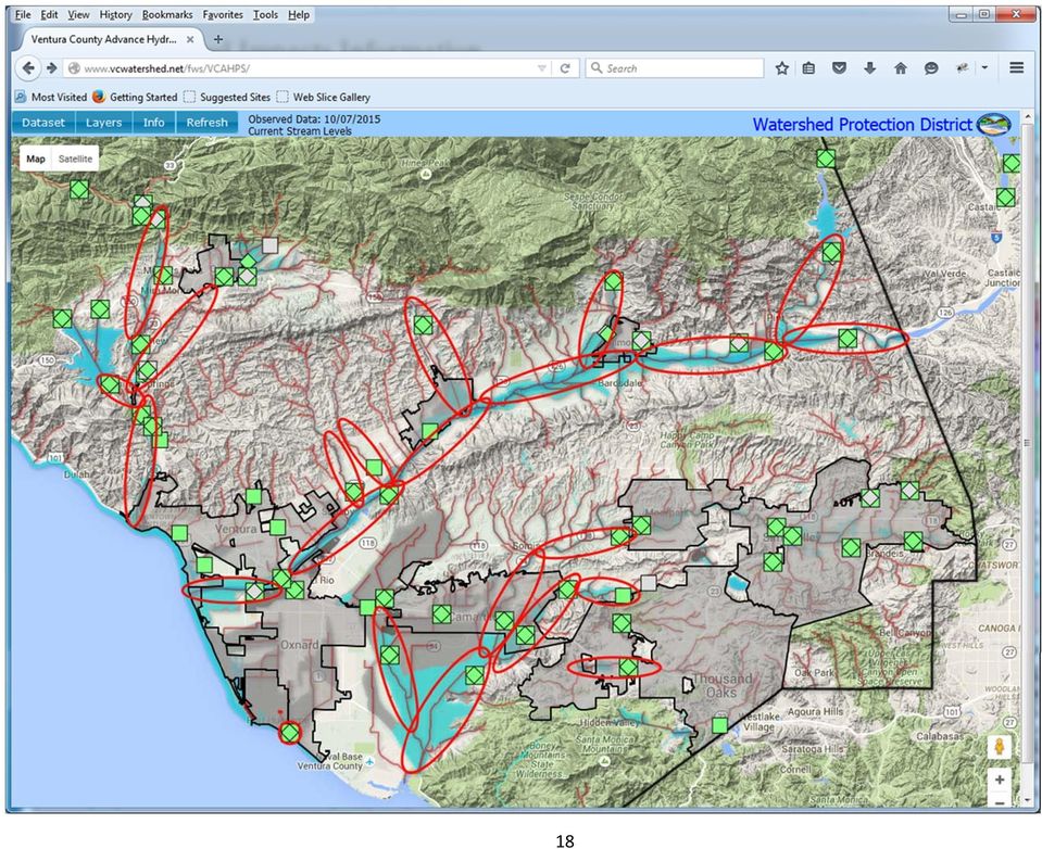
17 Note: Floodplain structures may not show in Google Chrome browser. Additional work is on going to determine the cause of this issue. The structures were digitized in a Geographic Information System (GIS) with aerial photo from 2014 and the latest FEMA Special Flood Hazard Area (SFHZ) overlay. Any structure in the Unincorporated Area of Ventura County that appears to be habitable or contains improvements like water or power that the property owner would insure with flood insurance were digitized. A summary table in the Flood Warning Program and Response Annex (FWRA), (part of the County of Ventura s 2015 Multi Hazard Mitigation Plan), for each watershed, which is broken down into individual streams, and lists the number of structures that met the criteria. These identified structures are the red squares available in the Floodplain Structures overlay. 4) Inundation Coverage The following map shows the areas that currently have mapped inundation areas. The inundation covers all major rivers and streams where riverine flooding occurs within the Unincorporated Areas of Ventura County. A few Incorporated City areas are covered where the major rivers (Ventura River, Santa Clara River, and Calleguas Creek) pass through the Incorporated City areas. The areas and gages that contain inundation mapping are marked on the map below as thick red ellipses. Unincorporated Areas of Ventura County that do not contain Special Flood Hazard Areas are not mapped. These areas includes the Los Padres National Forest and Santa Monica Mountains State and Federal areas. The Special Flood Hazard Areas are mapped as the cyan area on the map below. The Incorporated Cities are marked by the grey area within the thick black line. 17

18 18
Real Time Flood Alert System (RTFAS) for Puerto Rico
 for Puerto Rico") Prepared in cooperation with the Puerto Rico Emergency Management Agency (PREMA) Real Time Flood Alert System (RTFAS) for Puerto Rico Overview The Real Time Flood Alert System is a web-based computer program,
Prepared in cooperation with the Puerto Rico Emergency Management Agency (PREMA) Real Time Flood Alert System (RTFAS) for Puerto Rico Overview The Real Time Flood Alert System is a web-based computer program,
Water Monitoring System Website User Guide www.fldep-stevens.com
 Florida Department of Environmental Protection Division of State Lands Bureau of Survey and Mapping Water Monitoring System Website User Guide www.fldep-stevens.com Provided by Stevens Water Monitoring
Navigate to the web address: https://www.hertsdirect.org/ faultreporting/ You should be presented with the page shown here.
 Navigate to the web address: https://www.hertsdirect.org/ faultreporting/ You should be presented with the page shown here. In the large green area to the middle of the page, type in the road name you
Studying Topography, Orographic Rainfall, and Ecosystems (STORE)
") Studying Topography, Orographic Rainfall, and Ecosystems (STORE) Introduction Basic Lesson 2: Using ArcGIS Explorer to Analyze the Connection between Topography and Rainfall This lesson introduces Geographical
Studying Topography, Orographic Rainfall, and Ecosystems (STORE) Introduction Basic Lesson 2: Using ArcGIS Explorer to Analyze the Connection between Topography and Rainfall This lesson introduces Geographical
Improved Warnings for Natural Hazards: A Prototype System for Southern California
 Improved Warnings for Natural Hazards: A Prototype System for Southern California Yehuda Bock Research Geodesist Scripps Institution of Oceanography University of California San Diego, La Jolla, Calif.
How To Prepare For A Flood In Hampshire
 Chapter 6. Emergency Services Emergency services measures protect people during and after a flood. Locally, these measures are coordinated by the Huntsville-Madison County Emergency Management Agency.
NWS Flood Inundation Mapping Program
 NWS Flood Inundation Mapping Program Carson River Floodplain Management Forum April 22, 2015 Mark Faucette, Senior Forecaster Hydrology Program Manager NOAA/NWS, WFO Reno, NV NWS Hydrologic Services Program
Hydrologic Modeling using HEC-HMS
 Hydrologic Modeling using HEC-HMS Prepared by Venkatesh Merwade School of Civil Engineering, Purdue University vmerwade@purdue.edu April 2012 Introduction The intent of this exercise is to introduce you
NWSCHAT LIVE USER MANUAL
 NWSCHAT LIVE USER MANUAL March 11, 2012 Page 1 TABLE OF CONTENTS 1. Introduction... 3 2. Quick Start... 3 3. NWSChat Live Menu... 5 a. Actions menu... 5 b. Available (Status)... 5 c. Sound... 5 d. Buddies...
Chapter 6. Emergency Services
 Chapter 6. Emergency Services Most communities appoint an emergency manager or emergency services coordinator. This person is usually part time, although many communities make it an extra duty for a full-time
Watershed Ecosystem & Restoration Services (WERS Mapping Application) User s Guide
 User s Guide") Watershed Ecosystem & Restoration Services (WERS Mapping Application) User s Guide CONTACT Site Administrators: David Gillum, GISP, AACO, OIT Rick Fisher, AACO, WERS ITGILL00@aacounty.org rfisher@aacounty.org
Watershed Ecosystem & Restoration Services (WERS Mapping Application) User s Guide CONTACT Site Administrators: David Gillum, GISP, AACO, OIT Rick Fisher, AACO, WERS ITGILL00@aacounty.org rfisher@aacounty.org
Note taker: Katherine Willingham (NSSL)
") SMART-R Event Log IOP 3 Project: Debris Flow Project Lat: 34.200610 Lon: -118.350563 Alt: 712 ft. Truck HD: 193 deg Date/Time SR1 ready for operation: 12 December 2240 UTC Site: BUR Airport, Burbank CA
SMART-R Event Log IOP 3 Project: Debris Flow Project Lat: 34.200610 Lon: -118.350563 Alt: 712 ft. Truck HD: 193 deg Date/Time SR1 ready for operation: 12 December 2240 UTC Site: BUR Airport, Burbank CA
Environmental Data Services for Delaware:
 Environmental Data Services for Delaware: Serving Emergency Responders, Planners, and Researchers Network Delaware Day November 6, 2013 Overview Operational Data Services More than just research DEOS and
NOAA s National Weather Service Milwaukee/Sullivan
 NOAA s National Weather Service Milwaukee/Sullivan Marcia Cronce Meteorologist, Aviation Focal Point August 2014 weather.gov/milwaukee NWS Part of the Federal Government DOC - Department of Commerce NOAA
Flood Emergency Response Planning: How to Protect Your Business from a Natural Disaster RIC005
 Flood Emergency Response Planning: How to Protect Your Business from a Natural Disaster RIC005 Speakers: Tom Chan, CEO, Global Risk Miyamoto Greg Bates, Principal, Global Risk Consultants Learning Objectives
OnPoint 7.0 Tools and Functionality
 P a g e 1 OnPoint 7.0 Tools and Functionality The new version of the OnPoint website has the same functionality as the old site, but the look and feel of the page has changed. This document will compare
1. Where do I find the Grain Bids? 2. How do I customize my Grain Bid/Cash Bid location? 3. How do I view all direct ship bids at a glance?
 1. Where do I find the Grain Bids? You can find the grain bids one of three convenient ways: a. When viewing the IAS Grain Bids feature on the home page you can select Bid Details in the red box to view
Surviving the Storm Economic impacts of an acute flooding event in the Bay Area. Downtown San Anselmo. 2006 New Years Flood
 Surviving the Storm Economic impacts of an acute flooding event in the Bay Area. Downtown San Anselmo. 2006 New Years Flood Bay Area Council Water Committee: ABAG, BCDC, BART, SFO, Port of SF, Port of
Flood Protection Tips
 Flood Protection Tips Information About Floodplains and Flood Prevention What is a floodplain? Floodplains serve many useful purposes, and those that are preserved in their natural or nearly natural state
Standard Operating Procedures for Flood Preparation and Response
 Standard Operating Procedures for Flood Preparation and Response General Discussion Hurricanes, tropical storms and intense thunderstorms support a conclusion that more severe flooding conditions than
Indiana Office of Community and Rural Affairs. Disaster Recovery and Mitigation Planning Ft. Worth, Texas February 15, 2012
 Indiana Office of Community and Rural Affairs Disaster Recovery and Mitigation Planning Ft. Worth, Texas February 15, 2012 Floods Indiana s costliest hazard State ranks 5 th in annual median flood damages
National Dam Safety Program Technical Seminar #22. When is Flood Inundation Mapping Not Applicable for Forecasting
 National Dam Safety Program Technical Seminar #22 Thursday February 19 th 2015 Emmittsburg, MD When is Flood Inundation Mapping Not Applicable for Forecasting Victor Hom Hydrologic Services Division National
Chapter 7. Emergency Services
 Chapter 7. Emergency Services Emergency services measures protect people during and after a disaster. A good emergency management program addresses all hazards, and it involves all municipal and/or county
Section 19. Basin-wide Mitigation Action Plans
 Section 19. Basin-wide Mitigation Action Plans This Mitigation Plan identifies twelve specific hazards that could affect the Basin. Section 20 of this Plan set forth mitigation action plans to be carried
Hurricanes and Storm Surge www.hcfcd.org/tropicalweather
 Hurricanes and Storm Surge www.hcfcd.org High-level winds fl ow outward Strong surface winds spiral inward EYE Calm, sometimes cloudfree, sinking air Air sinks in calm area at the storm s eye THUNDERSTORMS
SITE SPECIFIC WEATHER ANALYSIS REPORT
 SAMPLE FLOOD ANALYSIS REPORT SITE SPECIFIC WEATHER ANALYSIS REPORT PREPARED FOR: Law Offices of Oliver Wendell Douglas Oliver Wendell Douglas PREPARED BY: November 29, 2007 CASE REFERENCE: Arnold Ziffel
HAZARD RISK ASSESSMENT, MONITORING, MAINTENANCE AND MANAGEMENT SYSTEM (HAMMS) FOR LANDSLIDE AND FLOOD. Mohd. Nor Desa, Rohayu and Lariyah, UNITEN
 FOR LANDSLIDE AND FLOOD. Mohd. Nor Desa, Rohayu and Lariyah, UNITEN") HAZARD RISK ASSESSMENT, MONITORING, MAINTENANCE AND MANAGEMENT SYSTEM (HAMMS) FOR LANDSLIDE AND FLOOD Mohd. Nor Desa, Rohayu and Lariyah, UNITEN WHAT WE HAVE IN MIND AND FROM OUR PREVIOUS PROJECT CONTRIBUTION
HAZARD RISK ASSESSMENT, MONITORING, MAINTENANCE AND MANAGEMENT SYSTEM (HAMMS) FOR LANDSLIDE AND FLOOD Mohd. Nor Desa, Rohayu and Lariyah, UNITEN WHAT WE HAVE IN MIND AND FROM OUR PREVIOUS PROJECT CONTRIBUTION
Supervised Classification workflow in ENVI 4.8 using WorldView-2 imagery
 Supervised Classification workflow in ENVI 4.8 using WorldView-2 imagery WorldView-2 is the first commercial high-resolution satellite to provide eight spectral sensors in the visible to near-infrared
Contents. The OWRB Floodplain Viewer. Creating Maps... 8. Helpful Tips... 10
 Contents QUICK START GUIDE... 2-5 Add layers...9 Search for Layers...9 COMPREHENSIVE GUIDE... 6 Navigate the map...6 Locate specific places...6 Add layer from file...9 Add layer from web...9 Display pop-up
ARE YOU PREPARED FOR A FLOOD IN YOUR NEIGHBORHOOD?
 ARE YOU PREPARED FOR A FLOOD IN YOUR NEIGHBORHOOD? YOU ARE RECEIVING THIS BROCHURE BECAUSE YOUR PROPERTY IS LOCATED WITHIN OR NEAR A SPECIAL FLOOD HAZARD AREA WITHIN UNINCORPORATED VENTURA COUNTY History
Jefferson County EMA and City of Birmingham Alert System
 First time user, click on Sign Up (Red Arrow). You can click on the blue Help and Answers button at any time during the registration process. Help and Answers Sign Up Fill out your profile information
Emergency Management is responsible for coordinating the City of Houston s preparation for and response to emergency situations.
 CITY OF HOUSTON Office of Emergency Management October 2004 Emergency Management is responsible for coordinating the City of Houston s preparation for and response to emergency situations. Houston is exposed
TROPICAL STORM ALLISON. Prepared by: John P. Ivey, PE, CFM Halff Associates, Inc. ASCE
 TROPICAL STORM ALLISON June 5-9, 5 2001 Prepared by: John P. Ivey, PE, CFM Halff Associates, Inc. ASCE Spring 2002 Meeting Arlington, Texas March 27-30, 2002 Tropical Storm Allison (TSA) The most extensive
Flood insurance why have it? Where can I buy it?
 Flood insurance why have it? Where can I buy it? NOAA/National Weather Service Des Moines, Iowa June 2010 Thank you for your interest in flood insurance. Below are frequently asked questions and answers
Next Generation Flood Alert in Houston
 Next Generation Flood Alert in Houston Philip B. Bedient Civil and Environmental Eng., Rice University Houston, TX Major Causes of Urban Flooding (Excess Water that Inundates) Highly Developed (urbanized)
Daily Operations Briefing Sunday, May 24, 2015 8:30 a.m. EDT
 Daily Operations Briefing Sunday, May 24, 2015 8:30 a.m. EDT Significant Activity May 23-24 Significant Events: Flooding Southern Plains Tropical Activity: Atlantic Tropical cyclone activity not expected
Recent Innovations In Virginia Dam Safety & Floodplain Management Program
 Recent Innovations In Virginia Dam Safety & Floodplain Management Program Robert T. Bennett, P.E., R.A., C.F.M. Director Dam Safety & Floodplain Management Virginia Department of Conservation & Recreation
Town of Warwick, Village of Florida, Village of Greenwood Lake and Village of Warwick MULTI JURISIDICTIONAL, MULTI HAZARD MITIGATION PLAN DRAFT
 Town of Warwick, Village of Florida, Village of Greenwood Lake and Village of Warwick MULTI JURISIDICTIONAL, MULTI HAZARD MITIGATION PLAN DRAFT Appendix B Historical Hazard Documentation Rev #0 May 2013
Post-Flood Assessment
 Page 1 of 7 Post-Flood Assessment CHAPTER 4 AGENCY COORDINATION Agency coordination is an essential element for the operation of the flood management systems in the Central Valley. Due to the nature of
End to End Multi Hazard Early Warning Systems By Curt Barrett Hydrometeorological Consultant
 End to End Multi Hazard Early Warning Systems By Curt Barrett Hydrometeorological Consultant Disaster Risk Management- East Asia and Pacific Experts Roundtable on Urban Flood Risk Management March 17,
2012 Flood Hazard Prevention By Building and Planning Operations Manager Lou Ann Patellaro
 2012 Flood Hazard Prevention By Building and Planning Operations Manager Lou Ann Patellaro In 1968, Congress created the National Flood Insurance Program (NFIP) to provide affordable flood insurance to
Guidance for Flood Risk Analysis and Mapping. Changes Since Last FIRM
 Guidance for Flood Risk Analysis and Mapping Changes Since Last FIRM May 2014 This guidance document supports effective and efficient implementation of flood risk analysis and mapping standards codified
Chapter 7. Emergency Services
 Chapter 7. Emergency Services Emergency services measures protect people during and after a disaster. A good emergency management program addresses all hazards and involves all City departments. At the
Association of State Flood Managers Annual Conference Wednesday, June 4, 2014
 Association of State Flood Managers Annual Conference Wednesday, June 4, 2014 Hillsborough County, In the Trenches Local Mitigation Eugene Henry, CFM, AICP Hazard Mitigation Manager Floodplain Administrator
City of London Climate Change Adaptation Strategy Dealing with Extreme Rainfall Events
 City of London Climate Change Adaptation Strategy Dealing with Extreme Rainfall Events May 29, 2014 Presented by: Berta Krichker M.Eng., FEC, P.Eng. Manager of Stormwater Unit Environmental and Engineering
Flood Insurance Repetitive Loss Property
 Flood Insurance Repetitive Loss Property When our system of canals, ditches and culverts was built over 20 years ago, it could handle all but the largest tropical storms and hurricanes; since then, urban
National Levee Database (NLD) Data Management Tool (DMT) Levee Data Manager User Manual 1.2
 Data Management Tool (DMT) Levee Data Manager User Manual 1.2") National Levee Database (NLD) Data Management Tool (DMT) Levee Data Manager User Manual 1.2 Prepared for (USACE) Cold Regions Research and Engineering Laboratory (CRREL) October 26, 2012 Document Change
National Levee Database (NLD) Data Management Tool (DMT) Levee Data Manager User Manual 1.2 Prepared for (USACE) Cold Regions Research and Engineering Laboratory (CRREL) October 26, 2012 Document Change
Latin American and Caribbean Flood and Drought Monitor Tutorial Last Updated: November 2014
 Latin American and Caribbean Flood and Drought Monitor Tutorial Last Updated: November 2014 Introduction: This tutorial examines the main features of the Latin American and Caribbean Flood and Drought
WEB MAPPING TOOL DOCUMENTATION
 ENTERPRISE ZONES RE DESIGNATION WEB MAPPING TOOL DOCUMENTATION January 26, 2015 COVER PAGE TABLE OF CONTENTS INTRODUCTION 1 APPLICATION LAYOUT 2 WEB MAP NAVIGATION 3 LOCATION SEARCH 4 MAP LEGEND 5 BASEMAP
Presented by: Michael DePue, PE, CFM Annual Georgia Association of Floodplain Management Conference Lake Lanier Islands, Georgia March 23, 2010
 Flood Types and Characteristics Presented by: Michael DePue, PE, CFM Annual Georgia Association of Floodplain Management Conference Lake Lanier Islands, Georgia March 23, 2010 Agenda Why study flood types?
A Flood Warning System for City of Findlay, Ohio
 A Flood Warning System for City of Findlay, Ohio Matt Whitehead US Geological Survey, Ohio Water Science Center 6480 Doubletree Avenue Columbus, Ohio 43229 Abstract The U.S. Geological Survey (USGS) and
Mariana Leckner, Ph.D., Professor, American Military University Thomas O. Herrington, Ph.D. Associate Professor, Stevens Institute of Technology
 Mariana Leckner, Ph.D., Professor, American Military University Thomas O. Herrington, Ph.D. Associate Professor, Stevens Institute of Technology National Hydrologic Warning Council Training Conference
UTILIZING GOOGLE EARTH AS A GIS PLATFORM FOR WEATHER APPLICATIONS
 UTILIZING GOOGLE EARTH AS A GIS PLATFORM FOR WEATHER APPLICATIONS Travis M. Smith 1,2 and Valliappa Lakshmanan 1,2 1 U. of Oklahoma/CIMMS; 2 NOAA/NSSL 1. Introduction Google Earth (formerly known as Keyhole;
Building Olive s Flood Resiliency
 Building Olive s Flood Resiliency Informed Flood Mitigation Planning The Local Flood Analysis Flood Advisory Committee Meeting #1 Town of Olive s Community Room 4/14/15 What is an LFA? 1. Uses science
Multi-Jurisdictional Hazard Mitigation Plan
 Flooding General Flooding is the leading cause of death among all types of natural disasters throughout the United States, with its ability to roll boulders the size of cars, tear out trees, and destroy
BECAUSE WEATHER MATTERS UBIMET
 UBIMET Weather Information and Alert Systems for Railroads UBIMET because weather matters One of the largest private weather services in Europe Provides severe weather warnings for more than 1 million
2015 CRS Community Outreach. City of Folly Beach, South Carolina Flood Plain Management Offices PO Box 48 Folly Beach, SC 29439 843-588-2447 ext 1838
 City of Folly Beach, South Carolina Flood Plain Management Offices PO Box 48 Folly Beach, SC 29439 843-588-2447 ext 1838 The dark line around this map delineates the extent of the Special Flood Hazard
Lecture 4: Streamflow and Stream Gauging
 Lecture 4: Streamflow and Stream Gauging Key Questions 1. What is stream discharge and what controls its magnitude? 2. What is a hydrograph? 3. Where is the velocity highest in a stream? 4. Where is the
Town of Ocean City, Maryland
 Town of Ocean City, Maryland Community Hurricane Preparedness May 13, 2009 Websites http://www.fema.gov/hazard/hurricane/index.shtm hurricanes http://www.fema.gov/plan/prevent/floodins/infocon.shtm National
Fort Dodge Stormwater Master Planning. Prepared By: Ralph C. Stark, Jr., P.E., C.F.M. Joel N. Krause, P.E., C.F.M.
 Fort Dodge Stormwater Master Planning Prepared By: Ralph C. Stark, Jr., P.E., C.F.M. Joel N. Krause, P.E., C.F.M. Project Location Project Background Flooding History Localized flooding and storm sewer
 Disaster Prevention Measures in Global-Local Context 4 th World Water Forum Dr. Yoshihiko Yamashita CTI Engineering Co., Ltd Association of Japanese Consulting Engineers Outline of Presentation Up-to to-date
Investigating World Development with a GIS
 Investigating World Development with a GIS Economic and human development is not consistent across the world. Some countries have developed more quickly than others and we call these countries MEDCs (More
SnapTrends v2.6. User Guide. www.snaptrends.com
 SnapTrends v2.6 User Guide www.snaptrends.com ABSTRACT The purpose of this document is to share best practices & describe the process for using the SnapTrends Location Based Social Listening Service STV042013
MODEL ANALYSES AND GUIDANCE (MAG) WEB APPLICATION
 WEB APPLICATION") MODEL ANALYSES AND GUIDANCE (MAG) WEB APPLICATION MAG User s Manual (Documentation Version 3.10) April 2016 Prepared by: Systems Integration Branch/Software Development Team NCEP Central Operations NOAA
MODEL ANALYSES AND GUIDANCE (MAG) WEB APPLICATION MAG User s Manual (Documentation Version 3.10) April 2016 Prepared by: Systems Integration Branch/Software Development Team NCEP Central Operations NOAA
LYON COUNTY GEOMOOSE 2 HELP DOCUMENT
 LYON COUNTY GEOMOOSE 2 HELP DOCUMENT TABLE OF CONTENTS Lyon County Geomoose 2 Help Document... 1 Introduction... 3 Quick Reference Chart... 4 The Interface... 4 The Table of Contents... 5 Quick Reference
ROSE CREEK WATERSHED HYDROLOGIC, HYDRAULIC, SEDIMENT TRANSPORT, AND GEOMORPHIC ANALYSES TASK 1 EXISTING DATA AND INFORMATION SUMMARY REPORT BACKGROUND
 ROSE CREEK WATERSHED HYDROLOGIC, HYDRAULIC, SEDIMENT TRANSPORT, AND GEOMORPHIC ANALYSES TASK 1 EXISTING DATA AND INFORMATION SUMMARY REPORT BACKGROUND The Rose Creek Watershed (RCW) consists of three planning
Create and share a map with GIScloud.com
 Create and share a map with GIScloud.com GIS Cloud is a web based Geographic Information System powered by Cloud Computing and with the full power of desktop GIS. It allows users to create and access your
Preparing for A Flood
 Preparing for A Flood 1. Know if you are in a flood prone area. 2. Each year, update flood procedures to be followed by your company, employees and tenants: Including Emergency Contacts Evacuation Plans
Flash Flood Science. Chapter 2. What Is in This Chapter? Flash Flood Processes
 Chapter 2 Flash Flood Science A flash flood is generally defined as a rapid onset flood of short duration with a relatively high peak discharge (World Meteorological Organization). The American Meteorological
APPENDIX G FLOOD WARNING RESPONSE PLAN
 ESCAMBIA COUNTY, FLORIDA DEPARTMENT OF PUBLIC SAFETY POLICY/PROCEDURE-Division of Emergency Management RE: Flood Warning Response Plan Approved by: Effective Date: August 27, 2007 Revised/Reviewed Date:
My City Houston Map Viewer, Version 2 Web Site
 My City Houston Map Viewer, Version 2 Web Site http://mycity.houstontx.gov/mycity2 GIS Helpline 832.393.6555 Developed and hosted by Enterprise GIS, Houston Information Technology Services, COH Using the
Introduction to Google Earth
 Center for Teaching, Research & Learning Social Science Research Lab American University, Washington, D.C. http://www.american.edu/provost/ctrl/ 202-885-3862 Introduction to Google Earth This tutorial
WebSphere Business Monitor V6.2 KPI history and prediction lab
 Copyright IBM Corporation 2009 All rights reserved IBM WEBSPHERE BUSINESS MONITOR 6.2 LAB EXERCISE WebSphere Business Monitor V6.2 KPI history and prediction lab What this exercise is about... 1 Lab requirements...
Reef Explorer User Guide
 Reef Explorer User Guide Contents USER INTERFACE...2 DATA CONTENT...3 BASEMAPS...4 ESRI BASEMAPS...4 National Geographic World Map...4 Light Gray Canvas Map...4 Ocean Basemap...4 World Terrain Base...4
DRAFT HAZARD MITIGATION PLAN TOOLKIT: MASTER TABLE
 DRAFT HAZARD MITIGATION PAN TOOKIT: MASTER TABE Steps Requirements Addressed Click to Overview slide presentation on "Getting Started Developing a Hazard Mitigation Plan" Plan Development Overview Introductory
Cabarrus County Floodplain Information TABLE OF CONTENTS
 Cabarrus County Floodplain Information TABLE OF CONTENTS Flood Hazard What is 100-year flood? Does Cabarrus County flood? Flood Safety How do I protect my property from flood damage? Is there anything
McIDAS-V Tutorial Using the McIDAS-X Bridge updated October 2010 (software version 1.0)
") McIDAS-V Tutorial Using the McIDAS-X Bridge updated October 2010 (software version 1.0) McIDAS-V is a free, open source, visualization and data analysis software package that is the next generation in
McIDAS-V Tutorial Using the McIDAS-X Bridge updated October 2010 (software version 1.0) McIDAS-V is a free, open source, visualization and data analysis software package that is the next generation in
Community RiskMAP Questionnaire
 Community RiskMAP Questionnaire Please provide the following information County Date: Community Name/Organization: Your Your E-mail: Contact Preference: E-mail Phone Mail The Federal Emergency Management
The guide uses the example files provided with Flood Modeller. Depending on your operating system these are located at:
 Getting Started 1D Modelling This document provides a quick start guide for new users of showing how to run a 1D model and view results. The guide uses the example files provided with. Depending on your
Regional Drought Decision Support System (RDDSS) Charting Tools Help Documentation
 Charting Tools Help Documentation") Regional Drought Decision Support System (RDDSS) Charting Tools Help Documentation The following help documentation was prepared to give insight to the basic functionality of the charting tools within
Regional Drought Decision Support System (RDDSS) Charting Tools Help Documentation The following help documentation was prepared to give insight to the basic functionality of the charting tools within
ONPOINT Internet Training Manual
 The Internet version of ONPOINT is for use by the general public and can be accessed from a computer that is on the Internet by using the following URL: (http://gis.arlingtonva.us/acmap ). OnPoint is fully
MERI Library Research Guide 2: Information on Flooding - Preparation, Prevention and Recovery
 MERI Library Research Guide 2: Information on Flooding - Preparation, Prevention and Recovery General Information This guide provides an overview of publications and online resources of interest to those
Disaster Risk Reduction through people centered National Multi-hazard Early Warning System in the context of Maldives
 Disaster Risk Reduction through people centered National Multi-hazard Early Warning System in the context of Maldives Abdul Muhusin, Deputy Director Department of Meteorology, Maldives Fourth Technical
Pennsylvania Flood Safety Awareness Week March 6-10th, 2015
 Pennsylvania Flood Safety Awareness Week March 6-10th, 2015 David J. Nicosia Warning Coordination Meteorologist National Weather Service Binghamton, NY Flooding is a coast to coast threat to the United
Texas Wildfire Risk Assessment Portal (TxWRAP) User Manual. Texas A&M Forest Service
 User Manual. Texas A&M Forest Service") Texas Wildfire Risk Assessment Portal (TxWRAP) User Manual Texas A&M Forest Service October 2012 Table of Contents 1 ABOUT TXWRAP... 7 1.1 ACCESSING TXWRAP... 7 1.2 GETTING SUPPORT... 8 Documentation...
Texas Wildfire Risk Assessment Portal (TxWRAP) User Manual Texas A&M Forest Service October 2012 Table of Contents 1 ABOUT TXWRAP... 7 1.1 ACCESSING TXWRAP... 7 1.2 GETTING SUPPORT... 8 Documentation...
What is a Search Engine?
 What is a Search Engine? Hi. It s me, Sarah and I m here to tell you about finding things on the Internet. The Internet brings together information from all over the world, which is a lot of information.
Los Angeles County. Open Pacific Coast Study. California Coastal Analysis and Mapping Project
 Los Angeles County Open Pacific Coast Study California Coastal Analysis and Mapping Project December 2011 Open Pacific Coast Counties Phase 1 Phase 2 California Coastal Analysis and Mapping Project Risk
ANALYSIS OF RAINFALL AND ITS INFLOW INTO MOBILE, ALABAMA S, ESLAVA SEWER SHED SYSTEM
 ANALYSIS OF RAINFALL AND ITS INFLOW INTO MOBILE, ALABAMA S, ESLAVA SEWER SHED SYSTEM Jerrod Frederking, Department of Earth Sciences, University of South Alabama, Mobile, AL 36688. E-mail: twisterj@gmail.com.
Remote Monitoring for the Next Generation of Traffic Controllers
 Remote Monitoring for the Next Generation of Traffic Controllers Iain Ross M.Phil B.Eng (Hons) Technical Manger at Motus Traffic Limited Abstract The Motus Traffic Remote Monitoring System (Motus RMS)
Community Rating System Progress Report August 2012
 Community Rating System Progress Report August 2012 Community NFIP Number Escambia County, Florida 120080 City of Pensacola, Florida 120082 Santa Rosa Island Authority 125138 A copy of the Community Rating
Earth Browser Users Guide
 Earth Browser Users Guide Earth Browser Users Guide Contents What is Earth Browser?... 3 Getting Started... 3 System Requirements... 3 Downloading... 3 Browsing the Earth... 4 Your Tools... 4 Hand Tool...4
IDOT Getting Around Illinois Interactive Map Quick Reference Guide
 IDOT Getting Around Illinois Interactive Map Quick Reference Guide 1 2 3 4 5 6 7 8 9 10 1) Navigation Tools The Navigation tools are used to reposition the visible area on the map display. Zoom In Clicking
FLOOD INFORMATION SERVICE EXPLANATORY NOTES
 FLOOD INFORMATION SERVICE EXPLANATORY NOTES Part 1 About the flood maps Limitations of the mapping What the maps don t show Where to find more information Definitions of words used to describe flooding.
The City of Ottawa Flood Hazards
 The City of Ottawa Flood Hazards The City of Ottawa is located in North Central LaSalle County, approximately 45 miles West of Joliet and 90 miles South of Rockford. The primary water course and sources
Mapping Your Land: An Overview for Landowners
 Mapping Your Land: An Overview for Landowners Online Mapping and Spatial Resources for the Private Forest Landowner Tutorials by John C. Gilbert 1 and John S. Kush 1 Design and Layout by Elizabeth P. Bowersock
Map Navigation Controls. An Interactive, Locally Based Knowledge Resource LivingstonLive.org/maps OR gisapps/livingstonviewerinternal
 Livingston County s Internet Mapping Portal User Guide An Interactive, Locally Based Knowledge Resource LivingstonLive.org/maps OR gisapps/livingstonviewerinternal A vast majority of County government
Flash Flood Guidance Systems
 Flash Flood Guidance Systems Introduction The Flash Flood Guidance System (FFGS) was designed and developed by the Hydrologic Research Center a non-profit public benefit corporation located in of San Diego,
Flood After Fire Fact Sheet
 FACT SHEET Flood After Fire Fact Sheet Risks and Protection Floods are the most common and costly natural hazard in the nation. Whether caused by heavy rain, thunderstorms, or the tropical storms, the
Networking Break 3:00 pm 3:30 pm
 Networking Break 3:00 pm 3:30 pm Sponsored by: Track D: Claims Technology & Innovation Forensic Meteorology: How Weather Experts, Advanced Data and Computer Models Are Now Being Used For Claims Investigations
Corsair Link v2.4 Manual. Initial Set-up. Placing devices within the chassis
 Corsair Link v2.4 Manual Initial Set-up Placing devices within the chassis When you first start up Corsair Link, there will be a list of auto-detected devices on the left column. You can drag and drop