Lewis Lapine, SCB&CB Chief, South Carolina Geodetic Survey
|
|
|
- Jason Barnett
- 9 years ago
- Views:
Transcription

1 The SC VRS Network Matt Wellslager Project Manager Lewis Lapine, SCB&CB Chief, South Carolina Geodetic Survey

2 South Carolina Geodetic Survey Geodetic and Mapping Services works cooperatively to provide current geodetic information and modern land information systems. The primary mission of the Geodetic Survey is to establish horizontal and vertical geodetic control throughout the state to allow land and land-related items to be referenced to the national horizontal and vertical coordinate system, to ensure the integrity of new geodetic data, and to maintain geodetic files. Mapping Coordination supports the development of an accurate, uniform statewide mapping system on a county-by-county base. These mapping systems will provide a large-scale map base for county and state land information systems that will enhance land records, engineering, land planning and economic development.

3 Centimeter Real Time Positioning Accuracy Using GPS 7 Years Ago Not Possible! Then there was RTK Expensive and Restrictive Use Now there is VRS Less expensive, Labor Efficient, Very Accurate

4 Before Virtual Reference Station (VRS) Real Time Kinematic All components must be present at the Base and Rover! GPS Antenna Data Link or Radio Modem and Radio Antenna Batteries GPS Receiver Data Collector

5


6 Technology

7 VRS Conventional State of the Art


8 SC - VRS Network Design -

9 Conceptual Layout of the SCVRS

10 Antenna Hardware Tamper-Proof Leveling Head Self Supporting 24 Foot Tower Stainless Steel Mount For Masonry Buildings


11 The NetR5 and HTTP Interface


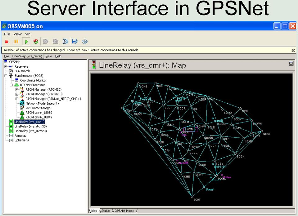
12 Server Interface in GPSNet

13 Components of the state vector ambiguity (meters) multipath (centimeters) ionosphere parameters :30 15: : : :30 15:00 differences between ambiguities are constant Japan, day 1 Japan, day 2 (shifted by 4 minutes) uncorrelated between stations days activity of ionosphere about to decline Use double differences together with code measurement and tropo model to resolve the ambiguity (FAMCAR)

14 Summary Model ionospheric phase advance in terms of a first order approximation across local area network Extract ionospheric parameters, multipath and double differenced ambiguities by means of a Kalman filter Obtain increased availability of network corrections and reliability for small to intermediate network sizes together with a physical picture of the evolution of the ionosphere


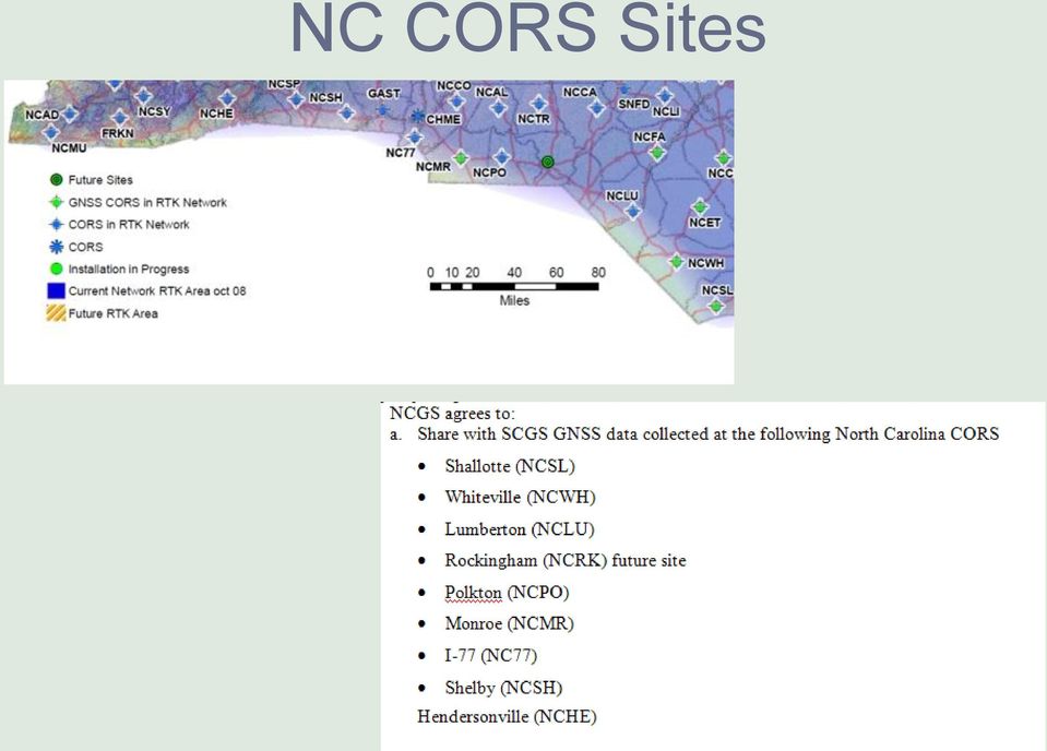
15 NC CORS Sites
16 Equipment Required to use the SCVRS 1. Dual Frequency GNSS Receiver - Capable of tracking multiple constellations. 2. Cellular Device 3. Cellular Carrier Service Digital Service required for data. Verizon, Alltel, Cingular 4. Data Collector collection software must be capable of broadcasting a GPS coordinate. 5. Adjustable or Fixed height Pole good if pole has a locking mechanism to prevent slippage.

17 The required components to use the VRS


18 Roving receiver sends an NMEA string back to server using cellular modem. Virtual Reference Station position is established. VRS VRS RTK

19 SC Prototype VRS Network

20 VRS Absolute Accuracy Comparison of VRS and NGS Height Mod Control Absolute Accuracy Meters Time (sec) Horizontal (cm) Vertical (cm) Allowable 2-D RMSE r 95% = * RMSE r = (2.0* * *1.2) 1/2 = 2.4 cm* Allowable 1-D RMSE v 95% = *RMSE v = (2.0* * *2.4) 1/2 = 3.1 cm* *(Local Accuracy 2 + Eccentricty 2 + System Design 2 ) 1/2
 1/2 = 3.")
21 Users of the SCVRS 1. SCDOT Originators for the network. Provided the money to get things started. 2. General Contractors for the SCDOT. Use the real time service for automated heavy machinery and earth moving. Envision as many as 50 bulldozers operating with VRS Service 3. The SC Society of Professional Land Surveyors 4. Academic Institutions that include: USC, Clemson, College of Charleston, the Citadel, Greenville Tech. and Midlands Tech. 5. Other State, County and Municipal organizations.
22 Practical Applications
23 Mean/SDV 0.001/0.008 Tidal Datum Transfer VRS Elevation (ft) Leveling (ft) Difference mile transfer 0.05 ft uncertainty

24 Trimble Integrity Manager
25 Test of VRS Vertical Accuracy Using 60 Second Sample NGS Elevation - VRS Elevation # of differences (m) 94% within 5cm (.164 ft)
26 Classical Leveling vs VRS 1 st Order Class 2 Leveling 4 Surveyors 4 days 5.5km 6mm 1 Surveyor 4 hours 12mm comparison
27 What needs to be done to improve results? 1. Attempt to separate the antenna from the receiver. 2. Use a geodetic grade antenna with ground plane. 3. Update roaming capabilities of cell phone. 4. Conduct a preplanned survey of points for optimal times of observations.
28 Advantages of the VRS Significantly reduces systematic errors Extended operating range with improved initialization and accuracy Increased productivity Single person surveying Eliminates need to establish reference station Set-up, power, physical security become non-issues
29 Advantages of VRS Eliminates dependency on single reference station Graceful degradation should a R.S. fail Uses established communications Establishes a single coordinate system
30
31 Thank-you
SURVEYING WITH GPS. GPS has become a standard surveying technique in most surveying practices
 SURVEYING WITH GPS Key Words: Static, Fast-static, Kinematic, Pseudo- Kinematic, Real-time kinematic, Receiver Initialization, On The Fly (OTF), Baselines, Redundant baselines, Base Receiver, Rover GPS
CHAPTER 3 PROJECT CONTROL
 CHAPTER 3 PROJECT CONTROL Marking Survey Control Points 3-2 Horizontal Control 3-2 Vertical Control 3-3 Preconstruction Bench Marks 3-3 Bench Mark Levels 3-3 Bench Mark Check Levels 3-5 Total Station Leveling
Leica SmartNet UK & Ireland Network RTK User Guide
 Leica SmartNet UK & Ireland Network RTK User Guide Contents Background.. Page 3 Single Base RTK.... Page 3 Advantages & Disadvantages of Single Base RTK Page 4 Network RTK... Page 4 Advantages & Disadvantages
Submitted to: Submitted by: Department of Geology and Mineral Industries 800 NE Oregon Street, Suite 965 Portland, OR 97232
 LIDAR REMOTE SENSING DATA COLLECTION DEPARTMENT OF F GEOLOGY AND MINERAL INDUSTRIES CRATER LAKE, OREGON NOVEMBER 30, 2010 Submitted to: Department of Geology and Mineral Industries 800 NE Oregon Street,
The Applanix SmartBase TM Software for Improved Robustness, Accuracy, and Productivity of Mobile Mapping and Positioning
 The Applanix SmartBase TM Software for Improved Robustness, Accuracy, and Productivity of Mobile Mapping and Positioning Joe Hutton and Edith Roy, Applanix Corporation Introduction Applanix, along with
SURVEY PRO. GPS Quick Start Guide
 SURVEY PRO GPS Quick Start Guide ii Table of Contents Before You Leave the Office...1 Survey Method: RTK or Post Processing...2 Receiver Setup...2 Receiver Settings...3 RTK Data Collection and Stake Out...4
Trimble R8 Base and Rover Quick Setup Guide. Inland GPS Inc.
 Trimble R8 Base and Rover Quick Setup Guide Inland GPS Inc. Setting up the GPS Base Equipment Hardware First Find the best, most advantageous secure place to setup the GPS base equipment. Look for a high
PLM PRODUCT INFORMATION
 PLM PRODUCT INFORMATION Agricultural Equipment UK & ROI Precision Farming Reference UK- PLM_03_13 Date: 1st May 2013 Announcing the new RangePoint RTX Correction Service RangePoint RTX is a GPS and GLONASS
Greg Keel P.Eng. Parallel Geo Services [email protected]
 Greg Keel P.Eng. Parallel Geo Services [email protected] Presentation Outline GNSS: Global Navigation Satellite System GPS: overview, current signals, modernization GLONASS: history (rise fall rise),
{ XE "CIR_30-6_intelligent_compaction_D02-26-14" } Page 1 of 10
 { XE "CIR_30-6_intelligent_compaction_D02-26-14" } Page 1 of 10 Section 30-6. Use to incorporate intelligent compaction requirements in CIR or FDR projects. Use bid item: 306100A Intelligent Compaction
Real-Time Reality by Arthur R. Andrew III, PLS
 Real-Time Reality by Arthur R. Andrew III, PLS A progressive RTK network in California deems the setting up of a base station a thing of the past. Imagine having the ability to survey using Real-Time Kinematic
GPS accuracy: Hand-held versus RTK
 GPS accuracy GPS accuracy: Hand-held versus RTK Kevin W. Hall, Joanna K. Cooper, and Don C. Lawton ABSTRACT Source and receiver points for seismic lines recorded during the geophysics field school near
GNSS and Heighting, Practical Considerations. A Parker National Geo-spatial Information Department of Rural Development and Land Reform
 GNSS and Heighting, Practical Considerations A Parker National Geo-spatial Information Department of Rural Development and Land Reform GNSS Global Navigation Satellite Systems (GNSS) Global Positioning
Specifications. Trimble SPS461 Modular GPS Heading Receiver
 Receiver Name Configuration Option Base and Rover interchangeability Rover position update rate Rover maximum range from base Rover operation within a VRS network Heading operation Factory options General
GPS Applications in Agriculture. Gary T. Roberson Agricultural Machinery Systems
 GPS Applications in Agriculture Gary T. Roberson Agricultural Machinery Systems What is a Positioning System? A position information system enables the user to determine absolute or relative location of
Survey Ties Guidelines
 North Carolina Board of Examiners for Engineers and Surveyors Survey Ties Guidelines The North Carolina Board of Examiners for Engineers and Surveyors is providing this document to serve as an interpretative
Prof. Ludovico Biagi. Satellite Navigation and Monitoring
 Prof. Ludovico Biagi Satellite Navigation and Monitoring Navigation: trajectories control positions estimations in real time, at high frequency popular applications: low accuracy (10 m) required specific
Introduction into Real-Time Network Adjustment with Geo++ GNSMART
 Introduction into Real-Time Network Adjustment with Geo++ GNSMART Andreas Bagge Gerhard Wübbena, Martin Schmitz Geo++ GmbH D-30827 Garbsen, Germany www.geopp.de GeoInformation Workshop 2004, Istanbul Kultur
GNSS FIELD DATA COLLECTION GUIDELINES
 AD-SDI DATA STANDARD GNSS FIELD DATA COLLECTION GUIDELINES Version 1.0 September 2011 Prepared by Abu Dhabi Spatial Data Infrastructure (AD-SDI) Abu Dhabi Systems and Information Centre (ADSIC) Abu Dhabi,
4.03 Vertical Control Surveys: 4-1
 4. HORIZONTAL AND VERTICAL CONTROL 4.01 General: Sufficient horizontal and, if applicable, vertical control surveys shall be established by the Contractor for all photogrammetric mapping purposes. Prior
Trimble Survey Controller Software (TSC2) Connection with mobile phone
 Connection with mobile phone") Trimble Survey Controller Software (TSC2) Connection with mobile phone In the main Windows screen, pick on the Start menu and then pick settings. In the Wireless Manager disable wireless internet. In the
Trimble Survey Controller Software (TSC2) Connection with mobile phone In the main Windows screen, pick on the Start menu and then pick settings. In the Wireless Manager disable wireless internet. In the
GPS Data Collection Procedures for Georeferencing Vegetation Resources Inventory and National Forest Inventory Field Sample Plots
 Province of British Columbia GPS Data Collection Procedures for Georeferencing Vegetation Resources Inventory and National Forest Inventory Field Sample Plots Resources Information Branch Ministry of Sustainable
Guidelines for RTK/RTN GNSS Surveying in Canada
 Guidelines for RTK/RTN GNSS Surveying in Canada July 2013 Version 1.1 Ministry of Transportation Ministère des Transports EARTH SCIENCES SECTOR GENERAL INFORMATION PRODUCT 100-E Main Authors: Brian Donahue,
Trimble Productivity: Making GPS Solutions Simple and Affordable. Trimble Site Positioning Systems:
 Trimble Productivity: Making GPS Solutions Simple and Affordable Trimble Site Positioning Systems: Smart GPS Antennas and Modular GPS Receivers Unmatched jobsite performance GPS: How Does It Work? Trimble
RELEASE NOTES. Trimble. SPS Series Receivers. Introduction. New features and changes
 RELEASE NOTES Trimble SPS Series Receivers Introduction New features and changes Version 4.41 Revision A April 2011 F Corporate office Trimble Navigation Limited Engineering and Construction group 5475
GPS Machine Control Grading & BIM (Building Information Modeling)
") GPS Machine Control Grading & BIM (Building Information Modeling) Shawn Herring ProSoft Civil Applications Engineer Training & Support Manager Follow us on any of these media sites Facebook ProSoft Twitter
GPS Machine Control Grading & BIM (Building Information Modeling) Shawn Herring ProSoft Civil Applications Engineer Training & Support Manager Follow us on any of these media sites Facebook ProSoft Twitter
Monitoring of High Rise Building using Real-Time Differential GPS
 Monitoring of High Rise Building using Real-Time Differential GPS Victor H.S. KHOO, Yam Khoon TOR and Gerry ONG, Singapore Key words: Global Positioning System (GPS), Differential GPS (DGPS), Structural
GNSS Base Station/Rover System. 1.1. The State will perform the purchase of the portable GNSS base/rover systems as follows:
 GNSS Base Station/Rover System 1. SCOPE 1.1. The State will perform the purchase of the portable GNSS base/rover systems as follows: 1.1.1. Purchase new Topcon GR-5 Portable GNSS Receivers (Survey Grade)
Receiver Name Configuration Option Base and Rover interchangeability. Rover operation within a VRS network Heading and Moving Base operation Yes 7
 Receiver Name Configuration Option Base and Rover interchangeability Rover position update rate Rover maximum range from base radio SPS852 Yes 1 Hz, 2 Hz, 5 Hz, 10 Hz, 20 Hz Unrestricted, typical range
Trimble CenterPoint RTX Post-Processing Services FAQs
 Trimble CenterPoint RTX Post-Processing Services FAQs What is Trimble RTX technology? 30 September 2013 Trimble RTX TM (Real Time extended) is a high-accuracy, global GNSS correction technology that combines
Enabling RTK-like positioning offshore using the global VERIPOS GNSS network. Pieter Toor GNSS Technology Manager
 Enabling RTK-like positioning offshore using the global VERIPOS GNSS network Pieter Toor GNSS Technology Manager Introduction PPP/RTK Positioning Techniques PPP-AR Technology Presentation Overview PPP-AR
Z-Max.Net >> GET FREE FROM OPERATIONAL CONSTRAINTS NETWORK GENERATION. www.thalesgroup.com/navigation
 Z-Max.Net NETWORK GENERATION >> GET FREE FROM OPERATIONAL CONSTRAINTS www.thalesgroup.com/navigation Z-Max.Net Liberate Yourself! Z-Max.Net is the next-generation survey solution from Thales. The.Net generation
Datasheet. Underground Utility 3-D Survey. Spar 300 Spar 300 RL1G1 Version 1.1
 Underground Utility 3-D Survey Datasheet Spar 300 Spar 300 RL1G1 Version 1.1 Optimal Ranging, Inc. 3251 Olcott St. Santa Clara, CA 95054 USA www.optimalranging.com +1 408 715 1222 [email protected]
MAGNET Field is a powerful and intuitive field
 MAGNET Field is a powerful and intuitive field application software that enables users to collect survey mapping data and perform construction and road layout using total stations, levels, and GPS. MAGNET
NJDEP GPS Data Collection Standards For GIS Data Development
 NJDEP GPS Data Collection Standards For GIS Data Development Bureau of Geographic Information Systems Office of Information Resource Management June 8, 2011 1.0 Introduction... 3 2.0 GPS Receiver Hardware
Analysis of RTN Measurement Results Referring to ASG-EUPOS Network
 GEOMATICS AND ENVIRONMENTAL ENGINEERING Volume 4 Number 1/1 2010 Andrzej Uznañski* Analysis of RTN Measurement Results Referring to ASG-EUPOS Network 1. Introduction In June 2008 ASG-EUPOS network system,
Model based quality assurance process in a infra construction. Case Riippa-Eskola RU2 double rail project
 Model based quality assurance process in a infra construction project Case Riippa-Eskola RU2 double rail project M. Jaakkola a and P. Toppi a a Destia Ltd, Development of Infra construction, Finland E-mail:
Swedish User Guidelines for Network RTK
 Swedish User Guidelines for Network RTK Robert Odolinski GNSS Research Centre, Curtin University of Technology (Previously Geodetic Research Department of Lantmäteriet, Sweden) Perth, WA, Australia [email protected]
GPS: A Primer. presented by Jim Pugh, GISP GIS Project Manager. 2007, EMH&T, Inc.
 GPS: A Primer presented by Jim Pugh, GISP GIS Project Manager GPS: A Primer GPS = Global Positioning System 24 Satellites in Orbit around Earth Each Broadcasts precise time and known location Receivers
Global Positioning System
 B. Hofmann-Wellenhof, H. Lichtenegger, and J. Collins Global Positioning System Theory and Practice Third, revised edition Springer-Verlag Wien New York Contents Abbreviations Numerical constants xix xxiii
GeoExplorer 2008 Series GeoXH Handheld: FAQs for Customers
 7 December 2009 GeoExplorer 2008 Series GeoXH Handheld: FAQs for Customers This document provides information that is common to all models of handheld in the Trimble GeoExplorer 2008 series, followed by
Earth Coordinates & Grid Coordinate Systems
 Earth Coordinates & Grid Coordinate Systems How do we model the earth? Datums Datums mathematically describe the surface of the Earth. Accounts for mean sea level, topography, and gravity models. Projections
GPS Positioning Modes
 5 GPS Positioning Modes Positioning with GPS can be performed in either of two ways: point (absolute) positioning or relative positioning. Classical GPS point positioning employs one GPS receiver that
Amr A. Oloufa, Won-seok Do, and H. Randolph Thomas. Penn State University aoloufa@psu. eclu
 iautomation and Robotics in Construction XVI 1999 by UC3M An Automated System for Quality Control of Compaction Operations : Receiver Tests & Algorithms Amr A. Oloufa, Won-seok Do, and H. Randolph Thomas
A totally SDR-based Low Cost Augmentation System for Institutional Applications
 A totally SDR-based Low Cost Augmentation System for Institutional Applications R. Capua, L. Gattuso, A. Caporale, M. Giangolini, F. Frittella, C. D Amico, D. Tufillaro 21 January 2016 R. Capua DO-11-DO-01
GeoMax GNSS Zenith10 & Zenith20 Series
 GeoMax GNSS Zenith10 & Zenith20 Series GeoMax About Us At GeoMax we provide a comprehensive portfolio of integrated solutions by developing, manufacturing and distributing quality construction and surveying
Local monitoring by low cost devices and free and open sources softwares
 Local monitoring by low cost devices and free and open sources softwares Abstract Ludovico Biagi, Florin-Catalin Grec, Marco Negretti, Maria Grazia Visconti Politecnico di Milano, DICA@ComoCampus The purpose
An Innovative Concept to Manage GPS Reference Stations Network and RTK Data Distribution Globally
 An Innovative Concept to Manage GPS Reference Stations Network and RTK Data Distribution Vincent LUI, Hong Kong SAR, China Key words: GPS reference station network, Internet, Spider, data management, integrity
INTRODUCTION TO GNSS NETWORK RTK. BAKU (AZERBAIDJAN) 12 Mai 2009. Ezzedine Djerbi Leica Geo-Systems Switzerland
 12 Mai 2009. Ezzedine Djerbi Leica Geo-Systems Switzerland") INTRODUCTION TO GNSS NETWORK RTK BAKU (AZERBAIDJAN) 12 Mai 2009 Ezzedine Djerbi Leica Geo-Systems Switzerland 1 GPS & GLONASS constellations have never been designed to serve the civilian applications
INTRODUCTION TO GNSS NETWORK RTK BAKU (AZERBAIDJAN) 12 Mai 2009 Ezzedine Djerbi Leica Geo-Systems Switzerland 1 GPS & GLONASS constellations have never been designed to serve the civilian applications
TRIMBLE ATS TOTAL STATION ADVANCED TRACKING SYSTEMS FOR HIGH-PRECISION CONSTRUCTION APPLICATIONS
 TRIMBLE ATS TOTAL STATION ADVANCED TRACKING SYSTEMS FOR HIGH-PRECISION CONSTRUCTION APPLICATIONS BY MARTIN WAGENER APPLICATIONS ENGINEER, TRIMBLE EUROPE OVERVIEW Today s construction industry demands more
NAVICOM DYNAMICS RTK BASE STATION INSTALLATION AND COMMISSIONING INSTRUCTIONS
 NAVICOM DYNAMICS RTK BASE STATION INSTALLATION AND COMMISSIONING INSTRUCTIONS 1. Locate a suitable position inside the building to install the Base Station enclosure where mains power (240V AC) is available
GEOGRAPHIC INFORMATION SYSTEMS Lecture 21: The Global Positioning System
 GEOGRAPHIC INFORMATION SYSTEMS Lecture 21: The Global Positioning System The Global Positioning System - recognize that GPS is only one of several Global Navigation Satellite Systems (GNSS) - the Russian
GPS Precise Point Positioning with a Difference*
 GPS Precise Point Positioning with a Difference* Pierre Héroux and Jan Kouba Geodetic Survey Division, Geomatics Canada Natural Resources Canada 615 Booth Street Ottawa, Ontario K1A E9 [email protected]
Somero SiteShape System
 Somero SiteShape System www.somero.com [email protected] Somero Enterprises, LLC Corporate Office: 82 Fitzgerald Drive Jaffrey, NH 03452 603 532 5900 - phone 603 532 5930 - fax The Somero SiteShape System
Cost and Accuracy Analysis of Detail Measurements by Real-Time Kinematic GPS (RTK-GPS)
") Cost and Accuracy Analysis of Detail Measurements by Real-Time Kinematic GPS (RTK-GPS) Dr.Ayhan CEYLAN, Dr. Omer MUTLUOGLU and C. Ozer YIGIT, Turkey Key words: Detail measurement, RTK-GPS, Electronic Tacheometry.
Cost and Accuracy Analysis of Detail Measurements by Real-Time Kinematic GPS (RTK-GPS) Dr.Ayhan CEYLAN, Dr. Omer MUTLUOGLU and C. Ozer YIGIT, Turkey Key words: Detail measurement, RTK-GPS, Electronic Tacheometry.
Provide network RTK Services in a few simple steps
 RTRef System Provide network RTK Services in a few simple steps What is RTRef? RTRef is a software system to provide GNSS network corrections for accurate positioning. The system includes a web-based interface
GPS Data Collection Guidelines
 GPS Data Collection Guidelines Prepared by the Standards & Data Coordination Work Group of the NYS GIS Coordination Program Last Updated: April 2007 1 Executive Summary Purpose The goal of this document
Understanding Range for RF Devices
 Understanding Range for RF Devices October 2012 White Paper Understanding how environmental factors can affect range is one of the key aspects to deploying a radio frequency (RF) solution. This paper will
CORS/OPUS: Status & Future Prospects
 CORS/OPUS: Status & Future Prospects Richard Snay, Gerald Mader, & Neil Weston NOAA s National Geodetic Survey CORS Users Forum 44 th CGSIC Meeting Long Beach, CA September 21, 2004 Continuously Operating
Radio Technical Commission for Maritime Services. GPS Update. Bob Markle RTCM Arlington, VA USA. NMEA Convention & Expo 2010
 Radio Technical Commission for Maritime Services GPS Update NMEA Convention & Expo 2010 Bob Markle RTCM Arlington, VA USA What is RTCM? International non-profit scientific, professional and membership
Alberding precision agriculture solutions
 Alberding precision agriculture solutions Alberding GmbH AGRITECHNICA 2015, 8 14 November 2015, Hanover, Germany Presentation by: Tamás Horváth & Katrin Arendholz Alberding GmbH - Precision agriculture
CHAPTER 9 SURVEYING TERMS AND ABBREVIATIONS
 CHAPTER 9 SURVEYING TERMS AND ABBREVIATIONS Surveying Terms 9-2 Standard Abbreviations 9-6 9-1 A) SURVEYING TERMS Accuracy - The degree of conformity with a standard, or the degree of perfection attained
GPS Precise Point Positioning as a Method to Evaluate Global TanDEM-X Digital Elevation Model
 GPS Precise Point Positioning as a Method to Evaluate Global TanDEM-X Digital Elevation Model 7 th FIG Regional Conference TS 1C Advances in GNSS Positioning and Applications I Volker Schwieger 1, Jürgen
DESIMETERSYSTEM FOR HØYNØYAKTIG POSISJONERING OG NAVIGASJON
 DESIMETERSYSTEM FOR HØYNØYAKTIG POSISJONERING OG NAVIGASJON John A. Vint Survey Manager Thales GeoSolutions Norge AS Hønefoss, 7. november 2003 Scope of Presentation Introduction Summary of GPS Errors.
Monitoring of Open Pit Mines using Combined GNSS Satellite Receivers and Robotic Total Stations
 Monitoring of Open Pit Mines using Combined GNSS Satellite Receivers and Robotic Total Stations N. Brown Leica Geosystems, Switzerland S. Kaloustian Leica Geosystems, Switzerland M. Roeckle Leica Geosystems,
REGULATIONS FOR CELLULAR ANTENNA TOWERS AND CELLULAR TELECOMMUNICATIONS SERVICES
 REGULATIONS FOR CELLULAR ANTENNA TOWERS AND CELLULAR TELECOMMUNICATIONS SERVICES Joint City-County Planning Commission of Barren County, Kentucky 126 East Public Square City Hall Glasgow, KY 42141 A. PURPOSE:
Table of Contents 1. Introduction... 3 2. Installing Sxblue Server... 4 3. Principle of Operation... 6 4. Server Configuration... 7 4.
 SXBlue Server Table of Contents 1. Introduction... 3 2. Installing Sxblue Server... 4 3. Principle of Operation... 6 4. Server Configuration... 7 4.1 Server Status... 7 4.1.1 Info Clients... 8 4.1.2 Infos
WHAT YOU NEED TO USE THE STATE PLANE COORDINATE SYSTEMS
 WHAT YOU NEED TO USE THE STATE PLANE COORDINATE SYSTEMS N & E State Plane Coordinates for Control Points AZIMUTHS - True, Geodetic, or Grid - Conversion from Astronomic to Geodetic (LaPlace Correction)
SUPPLEMENTAL SPECIFICATIONS CROSS SLOPE VERIFICATION:
 September 22, 2009 Updated November 16, 2009 SUPPLEMENTAL SPECIFICATIONS CROSS SLOPE VERIFICATION: 1. DESCRIPTION: The cross slopes of the roadway are to be constructed as detailed in the plans and within
ELEMENTS OF SURVEYING FOR CADASTRAL MAPPING
 ELEMENTS OF SURVEYING FOR CADASTRAL MAPPING Chapter 4 2015 Cadastral Mapping Manual 4-0 Elements of Surveying and Mapping Utah's system of land surveying is the rectangular survey system as set forth on
INTEGRITY AND CONTINUITY ANALYSIS OCTOBER TO DECEMBER 2013 QUARTERLY REPORT FROM GPS. Integrity and Continuity Analysis 08/01/14 08/01/14 08/01/14
 INTEGRITY AND CONTINUITY ANALYSIS FROM GPS OCTOBER TO DECEMBER 2013 QUARTERLY REPORT Prepared by: M Pattinson (NSL) 08/01/14 Checked by: L Banfield (NSL) 08/01/14 Approved by: M Dumville (NSL) 08/01/14
Günter Seeber. Satellite Geodesy 2nd completely revised and extended edition
 Günter Seeber Satellite Geodesy 2nd completely revised and extended edition Walter de Gruyter Berlin New York 2003 Contents Preface Abbreviations vii xvii 1 Introduction 1 1.1 Subject of Satellite Geodesy...
Road Construction. Production Study. AccuGrade GPS & ATS Systems. MALAGA Demonstration & Learning Center
 AccuGrade GPS & ATS Systems Road Construction Production Study MALAGA Demonstration & Learning Center December 2006 2 TABLE OF CONTENTS ABSTRACT... 4 1 INTRODUCTION... 5 PERSONNEL... 6 EQUIPMENT... 6 2
The Evolution of the Global Navigation Satellite System (GNSS) Spectrum Use
 Spectrum Use") The Evolution of the Global Navigation Satellite System (GNSS) Spectrum Use Spectrum Management 2012 National Spectrum Management Association Scott Pace (with thanks to Chris Hegerty, MITRE) Space Policy
The Evolution of the Global Navigation Satellite System (GNSS) Spectrum Use Spectrum Management 2012 National Spectrum Management Association Scott Pace (with thanks to Chris Hegerty, MITRE) Space Policy
Cost-Effective Collection of a Network-Level Asset Inventory. Michael Nieminen, Roadware
 Cost-Effective Collection of a Network-Level Asset Inventory Michael Nieminen, Roadware Introduction This presentation is about using a mobile vehicle to collect roadway asset (feature) data. Asset/Feature
TerraSync Software and GPS Pathfinder Office Software
 ORIENTATION GUIDE TerraSync Software and GPS Pathfinder Office Software Orientation Guide Version 7.0 Revision A / May 2012 Version 5.3 TerraSync Version 5.3 GPS Pathfinder Office Corporate Office Trimble
Post Processing Service
 Post Processing Service The delay of propagation of the signal due to the ionosphere is the main source of generation of positioning errors. This problem can be bypassed using a dual-frequency receivers
The Application of a Remotely-Operated Hydrographic Survey Boat for Tailings Facility Bathymetry
 ABSTRACT 63 The Application of a Remotely-Operated Hydrographic Survey Boat for Tailings Facility Bathymetry Dr. Adrian McDonald The Oceanscience Group, USA ABSTRACT As the methods available for surveying
SKPOS ( EUPOS ) network solution monitoring application
 network solution monitoring application") S ( EUPOS ) network solution monitoring application Karol Smolík Branislav Droščák, PhD. Geodetic and Cartographic Institute BRATISLAVA [email protected] [email protected] 18 th conference
S ( EUPOS ) network solution monitoring application Karol Smolík Branislav Droščák, PhD. Geodetic and Cartographic Institute BRATISLAVA [email protected] [email protected] 18 th conference
Application for Digital Radio Multiplex Transmitter apparatus licence(s) Form R058 (In accordance with section 99 of the Radiocommunications Act 1992)
 Form R058 (In accordance with section 99 of the Radiocommunications Act 1992)") Application for Digital Radio Multiplex Transmitter apparatus licence(s) Form R058 (In accordance with section 99 of the Radiocommunications Act 1992) Use of form and instructions This form is to be used
Application for Digital Radio Multiplex Transmitter apparatus licence(s) Form R058 (In accordance with section 99 of the Radiocommunications Act 1992) Use of form and instructions This form is to be used
Online GPS processing services: an initial study
 GPS Solut (2006) 10: 12 20 DOI 10.1007/s10291-005-0147-5 ORIGINAL ARTICLE Reza Ghoddousi-Fard Peter Dare Online GPS processing services: an initial study Received: 15 September 2004 Accepted: 3 May 2005
GNSS permanent stations as the part of integrated geodetic system in Estonia
 GNSS permanent stations as the part of integrated geodetic system in Estonia Karin Kollo (MSc) Department of Geodesy Estonian Land Board United Nations/Croatia Workshop on the applications of Global Navigation
MobileMapper 6 White Paper
 MobileMapper 6 White Paper Meter-Level Mapping Accuracy With Post-Processing Introduction Since its introduction in February 2008, the Magellan MobileMapper 6 has been welcomed by the market as the only
Alberding DGNSS solutions for inland waterways
 Alberding DGNSS solutions for inland waterways December 2012 1/29 Alberding DGNSS solutions for inland waterways Tamás Horváth Alberding GmbH DISC 12 Vukovar 13 December 2012 Alberding DGNSS solutions
Precision Agriculture: Commonly Used Terms & Applications
 PRECISION AGRICULTURE SERIES TIMELY INFORMATION Agriculture, Natural Resources & Forestry INSIDE THIS PUBLICATION: August 2010 Precision Agriculture: Commonly Used Terms & Applications AgGIS a geographic
Real-Time Kinematic Surveying
 Real-Time Kinematic Surveying Training Guide F Part Number 33142-40 Revision D September 2003 Corporate Office Trimble Navigation Limited 645 North Mary Avenue Post Office Box 3642 Sunnyvale, CA 94088-3642
Online Precise Point Positioning Using the. Natural Resources Canada Canadian Spatial Reference System (CSRS-PPP)
") Online Precise Point Positioning Using the Natural Resources Canada Canadian Spatial Reference System (CSRS-PPP) Thomas Nylen and Seth White UNAVCO October 2007 I. Precise Point Positioning Precise Point
Online Precise Point Positioning Using the Natural Resources Canada Canadian Spatial Reference System (CSRS-PPP) Thomas Nylen and Seth White UNAVCO October 2007 I. Precise Point Positioning Precise Point
GPS LOCATIONS FOR GIS: GETTING THEM RIGHT THE FIRST TIME
 GPS LOCATIONS FOR GIS: GETTING THEM RIGHT THE FIRST TIME Caroline Erickson and Pierre Héroux Geodetic Survey Division, Geomatics Canada Natural Resources Canada 615 Booth Street Ottawa, Ontario K1A 0E9
The new ISO standard 17123-8 for checking GNSS field measuring systems
 The new ISO standard 1713-8 for checking GNSS field measuring systems Hans Heister Institute for Geodesy - Geodetic Metrology - UniBw München D-85577 Neubiberg [email protected] FIG Working Week - Stockholm
MoTeC USA GPS. Part # M GPS BL Available in 10 Hz or 20 Hz. USER MANUAL Version 1.4
 MoTeC USA GPS Part # M GPS BL Available in 10 Hz or 20 Hz. USER MANUAL Version 1.4 MoTeC USA GPS Copyright Motec Systems USA 2008 The information in this document is subject to change without notice. While
Amplification of the Radiation from Two Collocated Cellular System Antennas by the Ground Wave of an AM Broadcast Station
 Amplification of the Radiation from Two Collocated Cellular System Antennas by the Ground Wave of an AM Broadcast Station Dr. Bill P. Curry EMSciTek Consulting Co., W101 McCarron Road Glen Ellyn, IL 60137,
Leica GNSS Reference Antennas White Paper
 Leica GNSS Reference Antennas White Paper State of The Art, Leading Edge Geodetic Antennas from Leica Geosystems Justin Walford, Leica Geosystems BIOGRAPHY Justin Walford holds an M.Sc.E in Survey Engineering
0095.05 June 30. 2011 July 18, 2014 1 of 7
 Standard Number: Superseding: Effective Date: Page: 0095.05 June 30. 2011 July 18, 2014 1 of 7 Pole Attachments, Automated Meter Reading and Cellular Phone Antennas 1. Scope 2. Application This standard
Role and Importance TUSAGA-Active (Cors-tr) In Basis Of The Operations Cadastral Plan
 In Basis Of The Operations Cadastral Plan") Role and Importance TUSAGA-Active (Cors-tr) In Basis Of The Operations Cadastral Plan Tahsin KARA, M. Vahdet GEZER, Ömer SALGIN, Ali İLBEY, Serdar ERGÜNER, Erkan KULAKSIZ, Bilal ERKEK and Sedat BAKICI
Role and Importance TUSAGA-Active (Cors-tr) In Basis Of The Operations Cadastral Plan Tahsin KARA, M. Vahdet GEZER, Ömer SALGIN, Ali İLBEY, Serdar ERGÜNER, Erkan KULAKSIZ, Bilal ERKEK and Sedat BAKICI
GEOENGINE MSc in Geomatics Engineering (Master Thesis) Anamelechi, Falasy Ebere
 Anamelechi, Falasy Ebere") Master s Thesis: ANAMELECHI, FALASY EBERE Analysis of a Raster DEM Creation for a Farm Management Information System based on GNSS and Total Station Coordinates Duration of the Thesis: 6 Months Completion
Master s Thesis: ANAMELECHI, FALASY EBERE Analysis of a Raster DEM Creation for a Farm Management Information System based on GNSS and Total Station Coordinates Duration of the Thesis: 6 Months Completion