Earth Coordinates & Grid Coordinate Systems
|
|
|
- Osborn Simpson
- 7 years ago
- Views:
Transcription
1 Earth Coordinates & Grid Coordinate Systems

2 How do we model the earth? Datums Datums mathematically describe the surface of the Earth. Accounts for mean sea level, topography, and gravity models. Projections Projections describe how to best fit a curve surface to a planar area (with minimal distortion) Coordinate Systems Coordinate Systems provide points of reference.

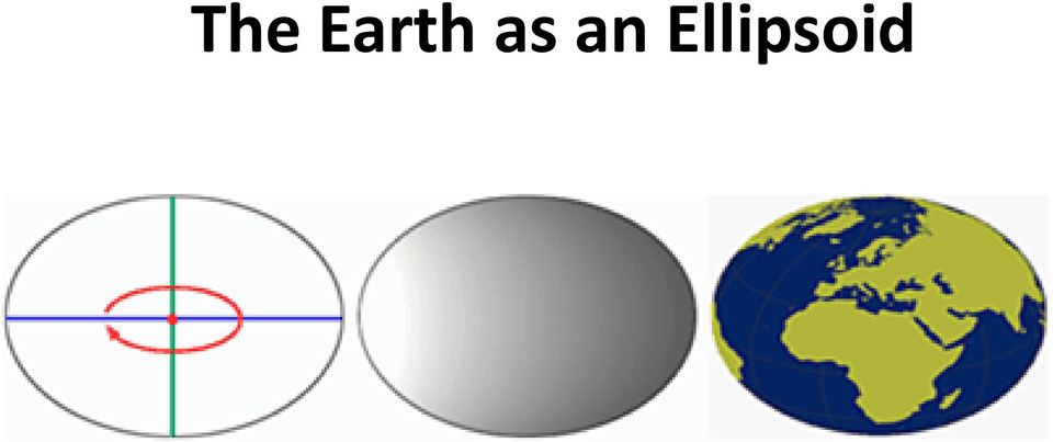
3 The Earth as an Ellipsoid
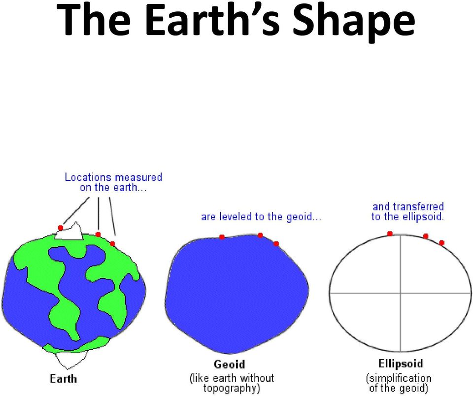
4 The Earth s Shape The geoid is the surface which would coincide exactly with the mean ocean surface of the Earth, if the oceans were to be extended through the continents.

5 Model of the Earth

6 The Earth s Shape
7 Definition: Datum A mathematical model that describes the shape of the ellipsoid Can be described as a reference mapping surface Defines the size and shape of the earth and the origin and orientation of the coordinate system used. There are local datums for different parts of the earth based on different measurements Datums are the basis for coordinate systems Assigning the wrong datum to a coordinate system may result in errors of hundreds of feet

8 Geodetic Datums

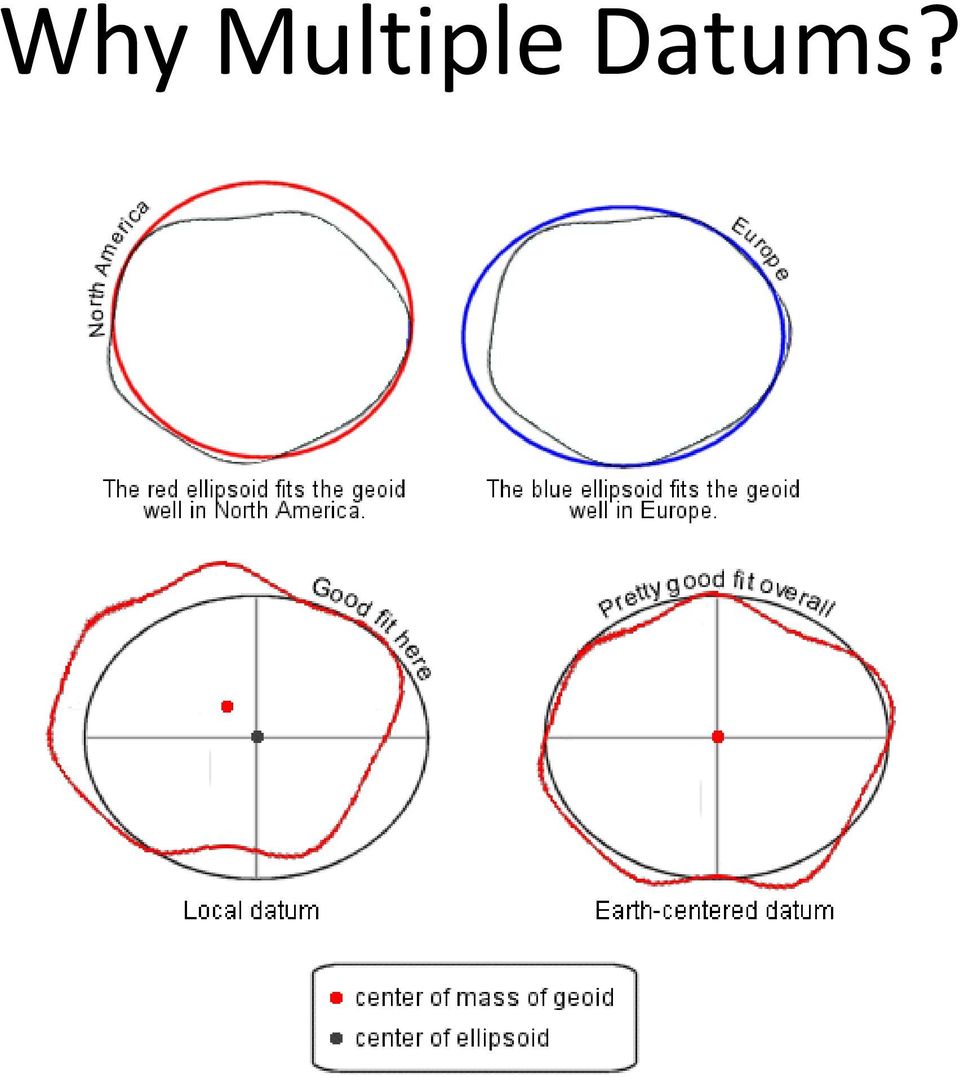
9 Why Multiple Datums?
10 Horizontal Reference Datums Datums are the collection of very accurate control points (points of known accuracy) surveyors use to geo-reference all other map data Surveyors determine the precise latitude and longitude of horizontal control points spread across the landscape

11 Horizontal Reference Datums Horizontal control point monuments

12 Horizontal control point monuments From the 1920s to the early 1980s,these control points were surveyed relative to the surface of the Clarke 1866 ellipsoid, together forming what is called the North American Datum of 1927 (NAD 27)

13 Difference Between NAD 27 and NAD 83 Position

14 Changes in Datums By the early 1980s, better knowledge of the earth s shape and size and far better surveying methods let to the creation of a new horizontal reference datum, the North American Datum of 1983 (NAD 83)

15 Changes in Datums The latitudes and longitudes of all of these points were determined relative to the Geodetic Reference System of 1980 (GRS 80) ellipsoid, which is essentially identical to the WGS 84 ellipsoid

16 The Earth as a Geoid The earth s surface is truly smooth when we compare the surface undulations to the 7,918 mile diameter of the earth The greatest relief variation is the approximately 12.3 mile difference between the summit of Mt. Everest (29,035 feet) and the deepest point in the Marianas Trench (36,192 feet)

17 The Earth as a Geoid The top of Mt. Everest is located at: 27 o 59 N, 86 o 56 E, 29,035 feet (8,852 meters)

18 Vertical Reference Datums The traditional datum used for land elevation is mean sea level (MSL) Surveyors define mean sea level as the average for all low and high tides at a particular starting location over a metonic cycle (the 19 year cycle of the lunar phases and days of the year)

19 Vertical Reference Datums A small circular monument was placed in the ground at each surveyed benchmark elevation point A benchmark is a permanent monument that establishes the exact elevation of a place

20 Vertical Reference Datums Later, surveyors could determine elevation by making gravity measurements at different locations on the landform and relating them to the strength of gravity at the point used to define MSL Gravity differences translate into elevation differences

21 Vertical Reference Datums Mean sea level is easy to determine along coastlines, but what about inland locations?
22 The Earth as a Geoid
23 Global Geoid The slightly undulating, nearly ellipsoidal surface that best fits mean sea level for all the earth s surface is called a global geoid The global geoid rises and falls approximately 100 meters above and below the oblate ellipsoid surface in an irregular pattern
24 Global Geoid World maps showing land topography and ocean bathymetry use land heights and water depths relative to the global geoid surface Be aware that the local geoid used in your area is probably slightly above or below (usually within 2 meters) the global geoid elevations used on world maps
25 NGVD 29 In the US you may see elevations relative to the National Geodetic Vertical Datum of 1929 (NGVD 29) on older topographic maps This datum was defined by the observed heights of mean sea level at 26 tide gauges, 21 in the US and 5 in Canada
26 North American Vertical Datum of 1988 (NAVD 88) Mean sea level for the continent was defined at one tidal station on the St. Lawrence River at Rimouski, Quebec, Canada
27 GPS For Measuring Elevation GPS receivers calculate what is called the ellipsoidal height, the distance above or below the surface of the WGS 84 ellipsoid along a line from the surface to the center of the earth
28 GPS For Measuring Elevation
29 GPS For Measuring Elevation You must convert GPS ellipsoidal height values to mean sea level datum elevations before you can use them with existing maps
30 Geoid Heights in the US
31 Grid Coordinate Systems The latitude and longitude graticule has been used for over 2000 years as the worldwide locational reference system Geocentric latitude and longitude coordinates on a sphere or geodetic latitudes and longitudes on an oblate ellipsoid, still key to modern position finding, are not as well suited for making measurements of length, direction and area on the earth s surface
32 Grid Coordinate Systems The advantage of the flat map projection surface is that we can locate something by using a two-axis coordinate reference system This coordinate system is the basis for the square grid of horizontal and vertical lines on a map
33 Geographical Coordinates Graticule Latitude Longitude
34 Grid Coordinate Systems We call a plane-rectangular coordinate system based upon and mathematically placed on a map projection a grid coordinate system All geographic grid systems are based on Cartesian coordinates, invented in 1637 by the famous French philosopher and mathematician Rene Descartes
35 Cartesian Coordinates If you superimpose a square grid on a map, with divisions on a horizontal x-axis and a vertical y-axis where the axes cross at the system s origin, you have established the Cartesian Coordinate System
36 Cartesian Coordinates
37 Grid Coordinates Grid coordinates systems based on the Cartesian Coordinate System are especially handy for such map analysis procedures as finding the distance or direction between locations or determining the area of a mapped feature like a lake Two popular grid coordinate systems are: Universal Transverse Mercator (UTM) State Plane Coordinate System
38 Universal Transverse Mercator System The UTM grid extends around the world from 84 o N to 80 o S 60 north-south zones are used, each 6 o longitude
39 Universal Transverse Mercator System
40 Universal Transverse Mercator System Each zone has its own central meridian and uses a secant case transverse Mercator projection centered on the zone s central meridian for each of the 60 zones Scale factors ranging from to within each zone
41 UTM Eastings Easting: the east-west x-coordinate in a grid coordinate system. That is the distance east from the origin In both the northern and southern hemispheres, an easting value of 500,000 meters (written 500,000mE) is assigned to the central meridian of each UTM zone This value, called the false easting, is added to all x-coordinates so that there are no negative eastings in the zone
42 UTM Northings In the northern hemisphere a northing value of 0mN is assigned to the equator so all northing values are positive numbers In the southern hemisphere, the equator is given a false northing of 10,000,000mN
43 UTM Example
44 Another UTM Example UTM Coordinates of the 68 th St Entrance to the North Building mE, mN, Zone 18 North
45 UTM All GPS vendors program the UTM specifications into their receivers Note that UTM coordinates will differ when different datums are used
46 Universal Polar Stereographic System To complete the global coverage, a complementary rectangle coordinate system called the universal polar stereographic (UPS) system was created UPS grid consists of a north zone and a south zone Each zone is superimposed on a secant case polar stereographic projection that covers a circular region over each pole
47 Universal Polar Stereographic System
48 State Plane Coordinate (SPC) System The idea was to completely cover the US and its territories with grids laid over map projection surfaces so that the maximum scale distortion error would not exceed 1 part in 10,000 The US was originally divided into 125 zones Each has its own projection surface based on the Clarke 1866 ellipsoid and NAD 27 geodetic latitudes and longitudes
49 State Plane Coordinate (SPC) System
50 State Plane Coordinate (SPC) System Secant case Lambert conformal conic projections are used for states of predominantly east-west extent Secant case transverse Mercator projections are used for states of greater north-south extent
51 State Plane Coordinate (SPC) System Zone boundaries follow state and county boundaries because surveyors have to register land surveys in a particular county Each zone has its own central meridian that defines the vertical axis for the zone An origin is established to the west and south of the zone
52 State Plane Coordinate (SPC) System Usually 2,000,000 feet west of the central meridian for the Lambert conformal conic zones and 500,000 feet for the transverse Mercator zones
53 State Plane Coordinate (SPC) System For example the location of the state capitol dome in Madison Wisconsin is: 2,164,600 ft E, 392,280 ft N, Wisconsin, south zone
54 Other Grid Systems US state grids combine UTM zones into a single state grid European grid coordinate systems British National Grid coordinate system Swiss coordinate system
Lecture 2. Map Projections and GIS Coordinate Systems. Tomislav Sapic GIS Technologist Faculty of Natural Resources Management Lakehead University
 Lecture 2 Map Projections and GIS Coordinate Systems Tomislav Sapic GIS Technologist Faculty of Natural Resources Management Lakehead University Map Projections Map projections are mathematical formulas
The Map Grid of Australia 1994 A Simplified Computational Manual
 The Map Grid of Australia 1994 A Simplified Computational Manual The Map Grid of Australia 1994 A Simplified Computational Manual 'What's the good of Mercator's North Poles and Equators, Tropics, Zones
WHAT YOU NEED TO USE THE STATE PLANE COORDINATE SYSTEMS
 WHAT YOU NEED TO USE THE STATE PLANE COORDINATE SYSTEMS N & E State Plane Coordinates for Control Points AZIMUTHS - True, Geodetic, or Grid - Conversion from Astronomic to Geodetic (LaPlace Correction)
UTM Zones for the US UTM UTM. Uniform strips Scalable coordinates
 UTM UTM Uniform strips Scalable coordinates Globally consistent, most popular projection/coordinate system for regional to global scale geospatial data (i.e. satellite images global scale datasets USGS/EDC)
EPSG. Coordinate Reference System Definition - Recommended Practice. Guidance Note Number 5
 European Petroleum Survey Group EPSG Guidance Note Number 5 Coordinate Reference System Definition - Recommended Practice Revision history: Version Date Amendments 1.0 April 1997 First release. 1.1 June
THE UNIVERSAL GRID SYSTEM
 NGA Office of GEOINT Sciences Coordinate Systems Analysis (CSAT) Phone: 314-676-9124 Unclassified Email: coordsys@nga.mil March 2007 THE UNIVERSAL GRID SYSTEM Universal Transverse Mercator (UTM) Military
量 說 Explanatory Notes on Geodetic Datums in Hong Kong
 量 說 Explanatory Notes on Geodetic Datums in Hong Kong Survey & Mapping Office Lands Department 1995 All Right Reserved by Hong Kong Government 留 CONTENTS INTRODUCTION............... A1 HISTORICAL BACKGROUND............
An Introduction to Coordinate Systems in South Africa
 An Introduction to Coordinate Systems in South Africa Centuries ago people believed that the earth was flat and notwithstanding that if this had been true it would have produced serious problems for mariners
WGS AGD GDA: Selecting the correct datum, coordinate system and projection for north Australian applications
 internal report WGS AGD GDA: Selecting the correct datum, coordinate system and projection for north Australian applications JBC Lowry Hydrological and Ecological Processes Program Environmental Research
The Earth Really is Flat! The Globe and Coordinate Systems. Long History of Mapping. The Earth is Flat. Long History of Mapping
 The Earth Really is Flat! The Globe and Coordinate Systems Intro to Mapping & GIS The Earth is Flat Day to day, we live life in a flat world sun rises in east, sets in west sky is above, ground is below
What are map projections?
 Page 1 of 155 What are map projections? ArcGIS 10 Within ArcGIS, every dataset has a coordinate system, which is used to integrate it with other geographic data layers within a common coordinate framework
2 GIS concepts. 2.1 General GIS principles
 2 GIS concepts To use GIS effectively, it is important to understand the basic GIS terminology and functionality. While each GIS software has slightly different naming conventions, there are certain principles
Gravitational potential
 Gravitational potential Let s assume: A particle of unit mass moving freely A body of mass M The particle is attracted by M and moves toward it by a small quantity dr. This displacement is the result of
Keywords: coordinate systems, latitude, longitude, georeferencing, global positioning system, GPS, geodetic datum, ellipsoid, geocoding, postal code
 Core Curriculum-Geographic Information Science (1997-2000) UCSB Peer Reviewed Title: Units 012-017 - Position on the Earth Book Title: Core Curriculum in Geographic Information Science Author: 012-017,
Geomatics Guidance Note 3
 Geomatics Guidance Note 3 Contract area description Revision history Version Date Amendments 5.1 December 2014 Revised to improve clarity. Heading changed to Geomatics. 4 April 2006 References to EPSG
A guide to coordinate systems in Great Britain
 A guide to coordinate systems in Great Britain An introduction to mapping coordinate systems and the use of GPS datasets with Ordnance Survey mapping D00659 v2.3 Mar 2015 Crown copyright Page 1 of 43 Contents
NGA GRID GUIDE HOW TO USE ArcGIS 8.x ANS 9.x TO GENERATE MGRS AND OTHER MAP GRIDS
 GEOSPATIAL SCIENCES DIVISION COORDINATE SYSTEMS ANALYSIS TEAM (CSAT) SEPTEMBER 2005 Minor Revisions March 2006 POC Kurt Schulz NGA GRID GUIDE HOW TO USE ArcGIS 8.x ANS 9.x TO GENERATE MGRS AND OTHER MAP
CHAPTER 3 PROJECT CONTROL
 CHAPTER 3 PROJECT CONTROL Marking Survey Control Points 3-2 Horizontal Control 3-2 Vertical Control 3-3 Preconstruction Bench Marks 3-3 Bench Mark Levels 3-3 Bench Mark Check Levels 3-5 Total Station Leveling
Coordinate Systems. Orbits and Rotation
 Coordinate Systems Orbits and Rotation Earth orbit. The earth s orbit around the sun is nearly circular but not quite. It s actually an ellipse whose average distance from the sun is one AU (150 million
Measuring the Earth Using a GPS M. Scott Wilkerson & M. Beth Wilkerson, DePauw University, May 10, 2007
 Measuring the Earth Using a GPS M. Scott Wilkerson & M. Beth Wilkerson, DePauw University, May 10, 2007 Modified from: Kerski, J.J., 2007, Measuring the Earth s Circumference with GPS, Copyright ESRI,
PLOTTING SURVEYING DATA IN GOOGLE EARTH
 PLOTTING SURVEYING DATA IN GOOGLE EARTH D M STILLMAN Abstract Detail surveys measured with a total station use local coordinate systems. To make the data obtained from such surveys compatible with Google
UTM: Universal Transverse Mercator Coordinate System
 Practical Cartographer s Reference #01 UTM: Universal Transverse Mercator Coordinate System 180 174w 168w 162w 156w 150w 144w 138w 132w 126w 120w 114w 108w 102w 96w 90w 84w 78w 72w 66w 60w 54w 48w 42w
Maintaining High Accuracy in Modern Geospatial Data
 Maintaining High Accuracy in Modern Geospatial Data Patrick Cunningham President info@bluemarblegeo.com www.bluemarblegeo.com +1 (207) 582 6747 Copyright 2010 Blue Marble Geographics Concepts Geodesy -
Survey Ties Guidelines
 North Carolina Board of Examiners for Engineers and Surveyors Survey Ties Guidelines The North Carolina Board of Examiners for Engineers and Surveyors is providing this document to serve as an interpretative
WILD 3710 Lab 3: GIS Data Exploration Camp W.G. Williams
 WILD 3710 Lab 3: GIS Data Exploration Camp W.G. Williams -Laboratory- TAs and Lab Instructors: Chris McGinty chris@gis.usu.edu Office: JQL 146 Office Hours: W 2:30 3:30 or by appt. Alex Hernandez alex@gis.usu.edu
Vertical Datums: An Introduction and Software Review
 Vertical Datums: An Introduction and Software Review Areas to Cover Theoretical Introduction Representation in EPSG Representation in OGC WKT Incorporation in PROJ.4 Incorporation in GDAL Future Work Introduction
The Chief Directorate: National
 Surveying The South African Coordinate Reference System (Part 1) by Aslam Parker, Chief Directorate: National Geo-spatial Information This article will define the various elements of the South African
CHAPTER 8 - LAND DESCRIPTIONS
 CHAPTER 8 - LAND DESCRIPTIONS Notes: While the location of land is commonly referred to by street number and city, it is necessary to use the legal description in the preparation of those instruments relating
6. The greatest atmospheric pressure occurs in the 1) troposphere 3) mesosphere 2) stratosphere 4) thermosphere
 troposphere 3) mesosphere 2) stratosphere 4) thermosphere") 1. The best evidence of the Earth's nearly spherical shape is obtained through telescopic observations of other planets photographs of the Earth from an orbiting satellite observations of the Sun's altitude
1. The best evidence of the Earth's nearly spherical shape is obtained through telescopic observations of other planets photographs of the Earth from an orbiting satellite observations of the Sun's altitude
Surveying on NAD83 State Plane Coordinate System
 Surveying on NAD83 State Plane Coordinate System By Dr. Joshua Greenfeld Surveying Program Coordinator NJ Institute of Technology Objective Modern surveying operations which involves working with GIS/LIS
ELEMENTS OF SURVEYING FOR CADASTRAL MAPPING
 ELEMENTS OF SURVEYING FOR CADASTRAL MAPPING Chapter 4 2015 Cadastral Mapping Manual 4-0 Elements of Surveying and Mapping Utah's system of land surveying is the rectangular survey system as set forth on
CHAPTER 9 SURVEYING TERMS AND ABBREVIATIONS
 CHAPTER 9 SURVEYING TERMS AND ABBREVIATIONS Surveying Terms 9-2 Standard Abbreviations 9-6 9-1 A) SURVEYING TERMS Accuracy - The degree of conformity with a standard, or the degree of perfection attained
Geography I Pre Test #1
 Geography I Pre Test #1 1. The sun is a star in the galaxy. a) Orion b) Milky Way c) Proxima Centauri d) Alpha Centauri e) Betelgeuse 2. The response to earth's rotation is a) an equatorial bulge b) polar
Maps A Primer for Content & Production of Topographic Base Maps For Design Presented by SurvBase, LLC
 Maps A Primer for Content & Production of Topographic Base Maps For Design Presented by Definition and Purpose of, Map: a representation of the whole or a part of an area. Maps serve a wide range of purposes.
Using Geocoded TIFF & JPEG Files in ER Mapper 6.3 with SP1. Eric Augenstein Earthstar Geographics Web: www.es-geo.com
 Using Geocoded TIFF & JPEG Files in ER Mapper 6.3 with SP1 Eric Augenstein Earthstar Geographics Web: www.es-geo.com 1 Table of Contents WHAT IS NEW IN 6.3 SP1 REGARDING WORLD FILES?...3 WHAT IS GEOTIFF
Oregon Coordinate Reference System
 OREGON DEPARTMENT OF TRANSPORTATION Highway Division Geometronics Unit Ron Singh, PLS Geometronics Manager Chief of Surveys (503) 986-3033 Mark L. Armstrong, PLS NGS Oregon Advisor (503) 986-3775 Michael
GPS LOCATIONS FOR GIS: GETTING THEM RIGHT THE FIRST TIME
 GPS LOCATIONS FOR GIS: GETTING THEM RIGHT THE FIRST TIME Caroline Erickson and Pierre Héroux Geodetic Survey Division, Geomatics Canada Natural Resources Canada 615 Booth Street Ottawa, Ontario K1A 0E9
Using Google Earth to Explore Plate Tectonics
 Using Google Earth to Explore Plate Tectonics Laurel Goodell, Department of Geosciences, Princeton University, Princeton, NJ 08544 laurel@princeton.edu Inspired by, and borrows from, the GIS-based Exploring
GEOGRAPHIC INFORMATION SYSTEMS CERTIFICATION
 GEOGRAPHIC INFORMATION SYSTEMS CERTIFICATION GIS Syllabus - Version 1.2 January 2007 Copyright AICA-CEPIS 2009 1 Version 1 January 2007 GIS Certification Programme 1. Target The GIS certification is aimed
OBJECTIVES. Identify the means by which latitude and longitude were created and the science upon which they are based.
 Name: Key OBJECTIVES Correctly define: isolines, gradient, topographic map, contour interval, hachured lines, profile, latitude, longitude, hydrosphere, lithosphere, atmosphere, elevation, model EARTH
SESSION 8: GEOGRAPHIC INFORMATION SYSTEMS AND MAP PROJECTIONS
 SESSION 8: GEOGRAPHIC INFORMATION SYSTEMS AND MAP PROJECTIONS KEY CONCEPTS: In this session we will look at: Geographic information systems and Map projections. Content that needs to be covered for examination
CHAPTER 4 LEGAL DESCRIPTION OF LAND DESCRIBING LAND METHODS OF DESCRIBING REAL ESTATE
 r CHAPTER 4 LEGAL DESCRIPTION OF LAND DESCRIBING LAND A legal description is a detailed way of describing a parcel of land for documents such as deeds and mortgages that will be accepted in a court of
Introduction to GIS (Basics, Data, Analysis) & Case Studies. 13 th May 2004. Content. What is GIS?
 & Case Studies. 13 th May 2004. Content. What is GIS?") Introduction to GIS (Basics, Data, Analysis) & Case Studies 13 th May 2004 Content Introduction to GIS Data concepts Data input Analysis Applications selected examples What is GIS? Geographic Information
Introduction to GIS (Basics, Data, Analysis) & Case Studies 13 th May 2004 Content Introduction to GIS Data concepts Data input Analysis Applications selected examples What is GIS? Geographic Information
What causes Tides? If tidal forces were based only on mass, the Sun should have a tidegenerating
 What are Tides? Tides are very long-period waves that move through the oceans as a result of the gravitational attraction of the Moon and the Sun for the water in the oceans of the Earth. Tides start in
TIDES. 1. Tides are the regular rise and fall of sea level that occurs either once a day (every 24.8 hours) or twice a day (every 12.4 hours).
 or twice a day (every 12.4 hours).") TIDES What causes tides? How are tides predicted? 1. Tides are the regular rise and fall of sea level that occurs either once a day (every 24.8 hours) or twice a day (every 12.4 hours). Tides are waves
TIDES What causes tides? How are tides predicted? 1. Tides are the regular rise and fall of sea level that occurs either once a day (every 24.8 hours) or twice a day (every 12.4 hours). Tides are waves
The Globe Latitudes and Longitudes
 INDIAN SCHOOL MUSCAT MIDDLE SECTION DEPARTMENT OF SOCIAL SCIENCE The Globe Latitudes and Longitudes NAME: CLASS VI SEC: ROLL NO: DATE:.04.2015 I NAME THE FOLLOWING: 1. A small spherical model of the Earth:
ebb current, the velocity alternately increasing and decreasing without coming to
 Slack water (slack tide): The state of a tidal current when its velocity is near zero, especially the moment when a reversing current changes its direction and its velocity is zero. The term is also applied
4.03 Vertical Control Surveys: 4-1
 4. HORIZONTAL AND VERTICAL CONTROL 4.01 General: Sufficient horizontal and, if applicable, vertical control surveys shall be established by the Contractor for all photogrammetric mapping purposes. Prior
Module 11: The Cruise Ship Sector. Destination #3
 Module 11: The Cruise Ship Sector Destination #3 Cruise Destinations Welcome to your third destination. Use the following resource article to learn about the different oceans and time zones. Seen from
Finding location and velocity data for PBO GPS stations
 Finding location and velocity data for PBO GPS stations Original activity by Vince Cronin (Baylor University). Revisions by Beth Pratt-Sitaula (UNAVCO). Analyzing the velocities recorded at different GPS
SURVEYING WITH GPS. GPS has become a standard surveying technique in most surveying practices
 SURVEYING WITH GPS Key Words: Static, Fast-static, Kinematic, Pseudo- Kinematic, Real-time kinematic, Receiver Initialization, On The Fly (OTF), Baselines, Redundant baselines, Base Receiver, Rover GPS
Request for Proposals for Topographic Mapping. Issued by: Teton County GIS and Teton County Engineering Teton County, Wyoming
 Request for Proposals for Topographic Mapping Issued by: Teton County GIS and Teton County Engineering Teton County, Wyoming Proposals due: 2:00PM MDT July 1, 2015 Proposals may be delivered to: Teton
GNSS and Heighting, Practical Considerations. A Parker National Geo-spatial Information Department of Rural Development and Land Reform
 GNSS and Heighting, Practical Considerations A Parker National Geo-spatial Information Department of Rural Development and Land Reform GNSS Global Navigation Satellite Systems (GNSS) Global Positioning
Stream Channel Cross Sections for a Reach of the Boise River in Ada County, Idaho
 U.S. Department of the Interior U.S. Geological Survey In cooperation with Federal Emergency Management Agency, City of Boise, City of Garden City, City of Eagle, and Ada County Stream Channel Cross Sections
ADWR GIS Metadata Policy
 ADWR GIS Metadata Policy 1 PURPOSE OF POLICY.. 3 INTRODUCTION.... 4 What is metadata?... 4 Why is it important? 4 When to fill metadata...4 STANDARDS. 5 FGDC content standards for geospatial metadata...5
North American Horizontal Datums. Jan Van Sickle
 North American Horizontal Datums Jan Van Sickle http://www.holoscenes.com/cgi-bin/moin.cgi/easternobliquearc The New England Datum 1879 was the first geodetic datum of this type in the United States. The
Case Study Australia. Dr John Dawson A/g Branch Head Geodesy and Seismic Monitoring Geoscience Australia. Chair UN-GGIM-AP WG1 Chair APREF.
 Case Study Australia Dr John Dawson A/g Branch Head Geodesy and Seismic Monitoring Geoscience Australia Chair UN-GGIM-AP WG1 Chair APREF Page 1 Overview 1. Australian height system Australian Height Datum
GIS IN ECOLOGY: SPATIAL REFERENCING
 GIS IN ECOLOGY: SPATIAL REFERENCING Contents Introduction... 2 Coordinate Systems... 2 Map Projections... 3 Georeferencing... 5 Data Sources... 7 Tasks... 7 Undefined versus Unprojected Data... 7 Setting
NC General Statutes - Chapter 102 1
 Chapter 102. Official Survey Base. 102-1. Name and description. The official survey base for the State of North Carolina shall be a system of plane coordinates to be known as the "North Carolina Coordinate
Topo Grabber Help. 2010 Fountain Computer Products
 Topo Grabber Help Topo Grabber Help All rights reserved. No parts of this work may be reproduced in any form or by any means - graphic, electronic, or mechanical, including photocopying, recording, taping,
compass Encyclopedic Entry
 This website would like to remind you: Your browser (Apple Safari 7) is out of date. Update your browser for more security, comfort and the best experience on this site. Encyclopedic Entry compass For
ESTIMATION USABILITY OF THE FREE SOFTWARE FOR TRANSFORMATION OF GEODETIC COORDINATES BETWEEB LOCAL AND GLOBAL DATUMS-EXAMPLE OF THE ADRIATIC SEA
 ESTIMATION USABILITY OF THE FREE SOFTWARE FOR TRANSFORMATION OF GEODETIC COORDINATES BETWEEB LOCAL AND GLOBAL DATUMS-EXAMPLE OF THE ADRIATIC SEA Duplančić Leder, Tea; Faculty of Civil Engineering and Architecture,
COVER VERSION 10.4.12
 COVER VERSION 10.4.12 P a g e 1 Copyright notice This ebook is provided, and may be used, free of charge. Selling this ebook in its entirety, or extracts from it, is prohibited. Obtain permission from
Coordinate Conversions and Transformations including Formulas
 Geomatics Guidance Note Number 7, part 2 Coordinate Conversions and Transformations including Formulas Revised - April 2015 Page 1 of 145 Index Preface 4 Revision history 5 1 MAP PROJECTIONS AND THEIR
Hydrographic Survey of the Keith Lake-Salt Bayou System
 Hydrographic Survey of the Keith Lake-Salt Bayou System April 2007 Survey Prepared by: The Texas Water Development Board December 2007 Texas Water Development Board J. Kevin Ward, Executive Administrator
Learning about GPS and GIS
 Learning about GPS and GIS Standards 4.4 Understand geographic information systems (G.I.S.). B12.1 Understand common surveying techniques used in agriculture (e.g., leveling, land measurement, building
Plate Tectonics: Ridges, Transform Faults and Subduction Zones
 Plate Tectonics: Ridges, Transform Faults and Subduction Zones Goals of this exercise: 1. review the major physiographic features of the ocean basins 2. investigate the creation of oceanic crust at mid-ocean
Metadata for Big River Watershed Geologic and Geomorphic Data
 Metadata for Big River Watershed Geologic and Geomorphic Data Metadata are descriptions and information regarding compiled data. This appendix contains the metadata that describes the compiled data used
Using GNSS to establish a Height Datum on a Project
 Abstract Richard Stanaway Quickclose PO Box 1364 Carlton VIC 3053 Australia email: richard.stanaway@quickclose.com.au This paper explains in detail practical steps for establishing or extending a height
Lines of Latitude and Longitude
 ED 5661 Mathematics & Navigation Teacher Institute Keith Johnson Lesson Plan Lines of Latitude and Longitude Lesson Overview: This lesson plan will introduce students to latitude and longitude along with
2Digital tablets or computer scanners can
 Appendix A Measuring Lake Surface Area Lake surface area can be measured with a bathymetric map using any of the following techniques: 1One of the most accurate methods is to use a planimeter to trace
EPS 101/271 Lecture 11: GPS Data Collection, Mapping Using GPS and Uncertainties in GPS Positioning
 EPS 101/271 Lecture 11: GPS Data Collection, Mapping Using GPS and Uncertainties in GPS Positioning How GPS data is collected in GeoMapper Setting Time interval for reporting GPS measurements Modes of
TerraColor White Paper
 TerraColor White Paper TerraColor is a simulated true color digital earth imagery product developed by Earthstar Geographics LLC. This product was built from imagery captured by the US Landsat 7 (ETM+)
GPS accuracy: Hand-held versus RTK
 GPS accuracy GPS accuracy: Hand-held versus RTK Kevin W. Hall, Joanna K. Cooper, and Don C. Lawton ABSTRACT Source and receiver points for seismic lines recorded during the geophysics field school near
Lesson 2: The Nature of Real Property. Real Property. Real Property. Real Estate Principles of Georgia. vs. Personal Property.
 Real Estate Principles of Georgia Lesson 2: The Nature of Real Property 1 of 53 23 Real Property vs. Personal Property Two types of property: Real property, ( realty ), real estate Personal property (
Understanding Map Projections
 Understanding Map Projections Melita Kennedy ArcInfo 8 Copyright 1994, 1997, 1999, 2000 Environmental Systems Research Institute, Inc. All Rights Reserved. Printed in the United States of America. The
Understanding Map Projections
 Understanding Map Projections GIS by ESRI Copyright 1994 2001, 2003 2004 ESRI All rights reserved. Printed in the United States of America. The information contained in this document is the exclusive property
Getting Land Survey Vertical & Horizontal Control via the Internet
 Getting Land Survey Vertical & Horizontal Control via the Internet https://www.auroragov.org aka: City of Aurora home page ROLL OVER City Hall Dropdown will appear 1 PICK Maps In the Info List 2 PICK Mapping
EECS467: Autonomous Robotics Laboratory Prof. Edwin Olson. Map Projections and GPS
 EECS467: Autonomous Robotics Laboratory Prof. Edwin Olson Map Projections and GPS Cartography Several purposes of maps Geographic Information Systems (GIS) - Where is stuff? Measure distances, etc. Navigation
Part 4: Geodetic Control
 Geographic Information Framework Data Content Standard May 2008 Established by Office of Management and Budget Circular A-16, the Federal Geographic Data Committee (FGDC) promotes the coordinated development,
Tides and Water Levels
 Tides and Water Levels What are Tides? Tides are one of the most reliable phenomena in the world. As the sun rises in the east and the stars come out at night, we are confident that the ocean waters will
Water Monitoring System Website User Guide www.fldep-stevens.com
 Florida Department of Environmental Protection Division of State Lands Bureau of Survey and Mapping Water Monitoring System Website User Guide www.fldep-stevens.com Provided by Stevens Water Monitoring
Tides vs Elevations - What's the Difference?
 Tides vs Elevations - What's the Difference? By Joe Burnett Along the coastlines, everyone is familiar with tides and how they influence the water level. However, in inland situations along river systems
Orbital Mechanics and Space Geometry
 Orbital Mechanics and Space Geometry AERO4701 Space Engineering 3 Week 2 Overview First Hour Co-ordinate Systems and Frames of Reference (Review) Kepler s equations, Orbital Elements Second Hour Orbit
Celestial Sphere. Celestial Coordinates. Lecture 3: Motions of the Sun and Moon. ecliptic (path of Sun) ecliptic (path of Sun)
 ecliptic (path of Sun)") Lecture 3: Motions of the and Moon ecliptic (path of ) ecliptic (path of ) The 23.5 degree tilt of Earth s spin axis relative to its orbital axis around the causes the seasons Celestial Sphere Celestial
Lecture 3: Motions of the and Moon ecliptic (path of ) ecliptic (path of ) The 23.5 degree tilt of Earth s spin axis relative to its orbital axis around the causes the seasons Celestial Sphere Celestial
MiSP CYCLIC PHENOMENA TIDES AND MOON PHASES Teacher Guide, L1 L3. Introduction
 MiSP CYCLIC PHENOMENA TIDES AND MOON PHASES Teacher Guide, L1 L3 Introduction This unit will be implemented a little differently than most of the other MiSP units. Instead of day 1 including an introduction
3D Visualization of Seismic Activity Associated with the Nazca and South American Plate Subduction Zone (Along Southwestern Chile) Using RockWorks
 Using RockWorks") 3D Visualization of Seismic Activity Associated with the Nazca and South American Plate Subduction Zone (Along Southwestern Chile) Using RockWorks Table of Contents Figure 1: Top of Nazca plate relative
3D Visualization of Seismic Activity Associated with the Nazca and South American Plate Subduction Zone (Along Southwestern Chile) Using RockWorks Table of Contents Figure 1: Top of Nazca plate relative
Korea Geodetic Framework for Sustainable Development*
 UNITED NATIONS E/CONF.102/IP.17 ECONOMIC AND SOCIAL COUNCIL Nineteenth United Nations Regional Cartographic Conference for Asia and the Pacific Bangkok, 29 October 1 November 2012 Item 6(b) of the provisional
Topographic Maps Practice Questions and Answers Revised October 2007
 Topographic Maps Practice Questions and Answers Revised October 2007 1. In the illustration shown below what navigational features are represented by A, B, and C? Note that A is a critical city in defining
Stage 4. Geography. Blackline Masters. By Karen Devine
 1 Devine Educational Consultancy Services Stage 4 Geography Blackline Masters By Karen Devine Updated January 2010 2 This book is intended for the exclusive use in NSW Secondary Schools. It is meant to
GPS AS THE DEVICE OF JUNCTION OF TRIANGULATION NETWORKS
 GPS AS THE DEVICE OF JUNCTION OF TRIANGULATION NETWORKS L. VÖLGYESI and J. VARGA Department of Geodesy and Surveying Budapest University of Technology and Economy H-1521 Budapest, Hungary Abstract Conversion
Volumes of Revolution
 Mathematics Volumes of Revolution About this Lesson This lesson provides students with a physical method to visualize -dimensional solids and a specific procedure to sketch a solid of revolution. Students
FUNDAMENTALS OF LANDSCAPE TECHNOLOGY GSD Harvard University Graduate School of Design Department of Landscape Architecture Fall 2006
 FUNDAMENTALS OF LANDSCAPE TECHNOLOGY GSD Harvard University Graduate School of Design Department of Landscape Architecture Fall 2006 6106/ M2 BASICS OF GRADING AND SURVEYING Laura Solano, Lecturer Name
MODERN APPLICATIONS OF PYTHAGORAS S THEOREM
 UNIT SIX MODERN APPLICATIONS OF PYTHAGORAS S THEOREM Coordinate Systems 124 Distance Formula 127 Midpoint Formula 131 SUMMARY 134 Exercises 135 UNIT SIX: 124 COORDINATE GEOMETRY Geometry, as presented
Brevard County Public Works Finance and Contracts Administration
 Brevard County Public Works Finance and Contracts Administration Public Works Survey & Mapping Division Review Check Sheet for Land Acquisition, Drainage, Roadway and Pedway Expansion, Asbuilts, Maintenance
MINIMUM STANDARDS OF ACCURACY, CONTENT AND CERTIFICATION FOR SURVEYS AND MAPS ARTICLE I. TYPES OF SURVEYS
 MINIMUM STANDARDS OF ACCURACY, CONTENT AND CERTIFICATION FOR SURVEYS AND MAPS ARTICLE I. TYPES OF SURVEYS Current with material published in Conn.L.J. through 5/13/08 Sec. 20-300b-1. General There are
Weekend Cabin Retreat Project Site Plans
 Weekend Cabin Retreat Project Site Plans Sacramento City College EDT 300/ENGR 306 EDT 300/ENGR 306 - Site Plans 1 Cabin Project Site Plan/Bubble Diagram - Assignment 1 =10-0 Floor Plan - Assignment 1/4
Copyright 2011 Casa Software Ltd. www.casaxps.com. Centre of Mass
 Centre of Mass A central theme in mathematical modelling is that of reducing complex problems to simpler, and hopefully, equivalent problems for which mathematical analysis is possible. The concept of
Name Period 4 th Six Weeks Notes 2015 Weather
 Name Period 4 th Six Weeks Notes 2015 Weather Radiation Convection Currents Winds Jet Streams Energy from the Sun reaches Earth as electromagnetic waves This energy fuels all life on Earth including the
PREFACE. The many TRADOC service schools and DOD agencies that produce the ACCP materials administered by the AIPD develop them to the DETC standards.
 PREFACE The Army Institute for Professional Development (AIPD) administers the consolidated Army Correspondence Course Program (ACCP), which provides highquality, economical training to its users. The