INTRODUCTION TO GNSS NETWORK RTK. BAKU (AZERBAIDJAN) 12 Mai Ezzedine Djerbi Leica Geo-Systems Switzerland
|
|
|
- Joella Walker
- 8 years ago
- Views:
Transcription
1 INTRODUCTION TO GNSS NETWORK RTK BAKU (AZERBAIDJAN) 12 Mai 2009 Ezzedine Djerbi Leica Geo-Systems Switzerland 1

2 GPS & GLONASS constellations have never been designed to serve the civilian applications so far. They have been designed first for defense applications. However and thanks to the outstanding efforts and fair competition between research centers and universities, GPS has been turned to generate much more profit from and for civilian applications. The key was to process the GPS signals in such a way that the users can benefit of the same accuracy that they get from classical surveying instruments, first in post-processing and nowadays even in real time. 2

3 GPS & GLONASS is the key for precise positioning «Differential» Accuracy (m) 1.00 Ambiguities Not resolved 0.10 Ambiguities Resolved 0.01 Time (secs) h 3

4 Existing and future GNSS Based Surveying NAVSTAR GPS USA, military system, developed in the 70s GLONASS Russian equivalent to GPS, developed in the 80s GALILEO Europe s GNSS, civil system, under development Compass China s global navigation satellite system, under development

5 Future GNSS systems GNSS-based surveying.. today and in GPS and 18 GLONASS SV 2 frequencies (L1, L2) 26 observation per epoch on average in open sky 12 observations per epoch on average with obstructions RTK up to 50km 8 typical initialization time RTK accuracy ±15mm 32 GPS, 24 GLONASS, 30 Galileo SV (+ Comp.) 3 frequencies (L1, L2, L5) >80 observation per epoch on average in open sky 32 observations per epoch on average with obstructions RTK up to 80km 1 typical initialization time RTK accuracy ±10mm 5

6 REFERENCE STATION SOLUTIONS
7 TEMPORARY TO PERMANENT REFERENCE STATION versus 7 Temporary GNSS Base Station Permanent GNSS Reference Station

8 From Temporary to Permanent Reference Station Single Base Non permanent surveying base station. Must be set-up before starting to work each time with a watch operator! Permanent Reference station. Available any time 24/7 continuously without any operator 8

9 What is a C.O.R.S Continuously Operating Reference Station? A continuously operating GNSS reference station comprises a GNSS receiver and antenna set up in a stable manner at a safe location with a reliable power supply. The receiver operates continuously, logging raw data, perhaps also streaming (continuously outputting) raw data, and often outputting RTCM and DGPS data for transmission to RTK, GIS and GNSS navigation devices. The receiver is usually controlled by a computer that can be located remotely if necessary. The PC will usually download data files at regular intervals and pass them to a web site for access by the GNSS user community. 9

10 Component off GNSS Single Reference Station Installation: Open Sky - All in View Satellites GNSS Choke Ring Antenna Lightning Protection Meteo Station for Weather forecasting Stable Monumentation anchors in bed rock Tape targets for TPS monitoring Fence and Secured access GNSS receiver, power supply, communication equipment, air conditioning, anti bug.. 10

11 11

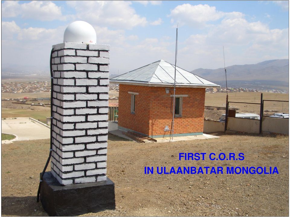
12 FIRST C.O.R.S IN ULAANBATAR MONGOLIA 12
13 - The seismic station with reference GPS station Kurty KAZAKHSTAN Chushkaly Chilik Kastek Nijnia Kamenka Maitube Turgen Saty Izvestkovyi Tean-Shan KYRGYZSTAN 13

14 Conventional Single G.N.S.S REFERENCE STATION RTK 14

15 RTK Single Base Station It s a Temporary installation on a tripod or Permanent station Reference, for GPS operations in a small area (up to 30km) over a limited time Accuracy, Reliability, Availability Good Poor 15

16 GNSS Single RTK Reduced productivity when operating long distances from the reference station 5 Km Quality Degradation with Distance Accuracy, Reliability, Availability Good Bad Km

17 Real time coverage Limitations of single GNSS Reference station RTK Accuracy, Reliability, Availability Good Poor 17 No continuity in quality of service (accuracy, reliability, availability) High density of stations required for good coverage Higher cost Multiple reference stations delivering RTK directly to users is not really a network

18 Single G.N.S.S REFERENCE STATION RTK Products 18

19 A GNSS Reference Station is a server of observations. ( GPS + Tilts + Meteo ) A Post-processing rover user wants to download RINEX files from a Web server ( FTP ) The Central Processing Facility need to control the server parameters and to collect observations from the RS server and to re-distribute observations and corrections. A RTK rover user wants to get in real time observations and corrections from the air (wireless Internet). 19

20 Single G.N.S.S REFERENCE STATION PRODUCTS RTK Rapid Static RTCM Broadcast GIS DGNS NSS RINEX Files Static RTK Rapid DGPS : 3 mm ( km) : 1 cm (30-50 km) : 5 mm (20 50 km) : 25 cm (150 km) 20
 : 5 mm (20 50 km) : 25 cm (150")
21 Applications Building Construction Utilities Sector GPS Monitoring Precise Vehicle Tracking Emergency Services Port Operations Land Surveying Machine Control Agriculture 21
22 BENEFITS: Single GNSS Permanent Reference Stations No local base station required Reduced user equipment costs Higher productivity Working on a common datum Power and communications Security Site selection clear sky view Common good infrastructure 22
23 If we need to cover a larger area? We have to «network» the single RS s 23
24 Motivation for Network RTK Improve accuracy, reliability and availability Make rover performance more uniform across the network Reduce the number of stations required to cover the area 24 Accuracy, Reliability, Availability Good Poor
25 Benefits of GPS RTK Network Extending the distance from a single reference station. Improving the accuracy on longer distances. Speeding up the initialization time over long distances. 75 to 100 Km 25
26 GNSS Network RTK Aux 10 Master Rover Aux 4 Aux 3 5 Km Aux km Accuracy, Reliability, Availability Good Bad Km
27 GNSS Survey assisted by GNSS Network RTK I don t care about setting up a Reference Station as I am operating in a GPS & GLONASS Network RTK! Will upload my data files and get the results back on my mail box thanks to the web portal! 27 I don t care about an RTK Base Station as I am operating in a GPS & GLONASS Network RTK! I am getting Real Time corrections and fix at 1 cm!
28 I just connect to a mobilephone number and the GNSS Rover RTK is getting corrections from KOCMOC Moscow to fix the point at 1 cm... My Total Station is getting precise coordinates by using GNSS receiver integrated and connected to the Kunming GNSS Network RTK 28
29 Network RTK BENEFITS Increased coverage Improved availability Improved reliability Faster rover initialisations Consistent high accuracy Higher productivity No local base station required Fewer reference stations needed Working on a common datum 29
30 Software Solutions & Management For Networks G.N.S.S 30
31 GPS Spider System Overview GPS Spider is the Leica GPS reference station and network software GPS Spider is built in different modules following an unique architecture offering both un-equalled flexibility and scalability SpiderNet is the networking solution of GPS Spider Conveniently configure and start GPS receivers Automatically monitor GPS receivers and data streams Manage GPS Raw and RINEX data Compute station coordinates in real-time or postprocessing for monitoring applications Process GPS Network corrections in real-time or postprocessing Generate and distribute Single Base and Network RTK corrections in various formats Manage and monitor RTK rover users, generate logs for accounting & billing 31
32 GNSS Networks SmartNet UK smartnet.leica-geosystems.co.uk Infrastructure Owned by Ordnance Survey Leica SmartNet GB Operational Dec Leica SmartNet Ireland Operational July 2007 Stations Ireland Network: 22 sites in total Stations GB Network: 123 sites in total GRX1200+ and AR25 19 GRX1200 GG Pro 32
33 Leica GNSS Spider Versatile Functionality Spider Business Center Unique User Management Manage RTK rover user access Authentication and authorisation for realtime product services Auditing and accounting allow to charge for services Advanced access control by data formats or access channel Regional geographic area Temporal restriction Multiple connections 33
34 Monitoring Software GNSS QC data analysis software GeoMoS multi-sensor monitoring software GPS Spider processing software Recent Projects Jiangyin Bridge, China IFC building, Hong Kong Ancona landslide monitoring, Italy 34
35 GNSS Reference Stations and Networks Expandable & Multi-Applications Bridge monitoring Tall Building monitoring Water Dam/Reservoir monitoring Seismic monitoring Landslide monitoring, subsidence Weather Forecasting Volcano monitoring Tide Gauge monitoring Agriculture Pipe Line, Oil and Gas Industry Offshore Platform Open Pit Mines Railway, Airport, Harbour Surveying & GIS 35
36 A GNSS Reference Station is Forever! 36
37 THANK YOU FOR YOUR ATTENTION AND COOPERATION 37
38 FD FD PW R OK WI C0 AC T/C H 0 A CT/CH 1 W IC 0 AC T/CH 0 AC T/C H1 ETH AC T CO L GPS SpiderNET Architecture Overview RTCM V2.3 DGPS Nearest Site MAX Auto-Cell RC user2 Remote GUI Graphical User Interface Site Server i-max RTCM Access Router RC FTP FD Remote Control FTP Data push File & Raw Data Network Server Data Archive Cluster Server (Network Processing) Cluster Server2 (Network Processing) RTK Proxy Server RTK Data distribuiton NTRIP i-max - RTCM RC Ethernet user2 Site Server Ntrip / CMR+ SingleSite TCP/IP MAX Auto-Cell 38
39 Why do monitoring? Everything is moving - How much? Measurements assists understanding long term monitoring and storage of results Measurements assist prediction - when will it fail? Operational efficiency steeper slopes in mines, reduced materials cost in contruction Safety of people, equipment and machinery (injuries or death, legal action, lost production) Slope/Structural management maintenance on demand Government regulations often require monitoring Reduce risk and insurance premiums - $$$$. 39
Leica SmartNet Commercial RTK Network Solution
 Leica SmartNet Commercial RTK Network Solution One person, one GPS receiver, one precise network solution Work Smart, choose Leica SmartNet Leica SmartNet is Britain and Ireland s first commercial RTK
An Innovative Concept to Manage GPS Reference Stations Network and RTK Data Distribution Globally
 An Innovative Concept to Manage GPS Reference Stations Network and RTK Data Distribution Vincent LUI, Hong Kong SAR, China Key words: GPS reference station network, Internet, Spider, data management, integrity
Leica SmartNet UK & Ireland Network RTK User Guide
 Leica SmartNet UK & Ireland Network RTK User Guide Contents Background.. Page 3 Single Base RTK.... Page 3 Advantages & Disadvantages of Single Base RTK Page 4 Network RTK... Page 4 Advantages & Disadvantages
Alberding precision agriculture solutions
 Alberding precision agriculture solutions Alberding GmbH AGRITECHNICA 2015, 8 14 November 2015, Hanover, Germany Presentation by: Tamás Horváth & Katrin Arendholz Alberding GmbH - Precision agriculture
Leica GR25 Don t think Receiver, think Reference Server
 Leica GR25 Don t think Receiver, think Reference Server Leica GR25 GNSS Reference Server Think Reference Server The GR25 is more than just a reference receiver, it is a GNSS Reference Server. Just like
Alberding DGNSS solutions for inland waterways
 Alberding DGNSS solutions for inland waterways December 2012 1/29 Alberding DGNSS solutions for inland waterways Tamás Horváth Alberding GmbH DISC 12 Vukovar 13 December 2012 Alberding DGNSS solutions
Leica Monitoring Solutions. Leica Monitoring Solutions Certainty builds confidence.
 Leica Monitoring Solutions Leica Monitoring Solutions Certainty builds confidence. Risk and Cost Reduction Proven Solutions Facing new challenges Engineering companies and contractors are facing challenges
GeoMax GNSS Zenith10 & Zenith20 Series
 GeoMax GNSS Zenith10 & Zenith20 Series GeoMax About Us At GeoMax we provide a comprehensive portfolio of integrated solutions by developing, manufacturing and distributing quality construction and surveying
The Applanix SmartBase TM Software for Improved Robustness, Accuracy, and Productivity of Mobile Mapping and Positioning
 The Applanix SmartBase TM Software for Improved Robustness, Accuracy, and Productivity of Mobile Mapping and Positioning Joe Hutton and Edith Roy, Applanix Corporation Introduction Applanix, along with
Monitoring of Open Pit Mines using Combined GNSS Satellite Receivers and Robotic Total Stations
 Monitoring of Open Pit Mines using Combined GNSS Satellite Receivers and Robotic Total Stations N. Brown Leica Geosystems, Switzerland S. Kaloustian Leica Geosystems, Switzerland M. Roeckle Leica Geosystems,
Geodetic Monitoring System Equipment List
 Geodetic Monitoring System Equipment List Table of Contents 1. GeoMoS Modules...4 1.1 GeoMoS Demo...4 1.2 GeoMoS Lite...4 1.3 GeoMoS Professional...5 1.3.1 GeoMoS Professional Option 1...5 1.3.2 GeoMoS
Enabling RTK-like positioning offshore using the global VERIPOS GNSS network. Pieter Toor GNSS Technology Manager
 Enabling RTK-like positioning offshore using the global VERIPOS GNSS network Pieter Toor GNSS Technology Manager Introduction PPP/RTK Positioning Techniques PPP-AR Technology Presentation Overview PPP-AR
Table of Contents 1. Introduction... 3 2. Installing Sxblue Server... 4 3. Principle of Operation... 6 4. Server Configuration... 7 4.
 SXBlue Server Table of Contents 1. Introduction... 3 2. Installing Sxblue Server... 4 3. Principle of Operation... 6 4. Server Configuration... 7 4.1 Server Status... 7 4.1.1 Info Clients... 8 4.1.2 Infos
GPS Data Collection Procedures for Georeferencing Vegetation Resources Inventory and National Forest Inventory Field Sample Plots
 Province of British Columbia GPS Data Collection Procedures for Georeferencing Vegetation Resources Inventory and National Forest Inventory Field Sample Plots Resources Information Branch Ministry of Sustainable
Initial Analysis of the Accuracy of Position Determination Using ASG-EUPOS NAVGEO (RTK VRS) Service
 Service") GEOMATICS AND ENVIRONMENTAL ENGINEERING Volume 4 Number 4 2010 Marcin Uradziñski*, Adam Doskocz* Initial Analysis of the Accuracy of Position Determination Using ASG-EUPOS NAVGEO (RTK VRS) Service 1. Introduction
GEOMATICS AND ENVIRONMENTAL ENGINEERING Volume 4 Number 4 2010 Marcin Uradziñski*, Adam Doskocz* Initial Analysis of the Accuracy of Position Determination Using ASG-EUPOS NAVGEO (RTK VRS) Service 1. Introduction
GEOGRAPHIC INFORMATION SYSTEMS Lecture 21: The Global Positioning System
 GEOGRAPHIC INFORMATION SYSTEMS Lecture 21: The Global Positioning System The Global Positioning System - recognize that GPS is only one of several Global Navigation Satellite Systems (GNSS) - the Russian
European Position Determination System. Guidelines For Cross- Border Data Exchange
 European Position Determination System Guidelines For Cross- Border Data Exchange Version 1.0 21 September 2006 Copyright: Publisher: 2007 by the International EUPOS Steering Committee Office of the International
Safety Applications for GPS Systems in the Mining Industry
 Safety Applications for GPS Systems in the Mining Industry Introduction The Global Positioning System (GPS) has been available for civilian use for more than 20 years now. It has found many navigation,
Alberding GNSS data management & monitoring tools
 Alberding GNSS data management & monitoring tools 1/24 Alberding GNSS data management & monitoring tools Tamás Horváth Alberding GmbH EUREF 2013 Symposium, 29-31 May 2013, Budapest, Hungary Alberding GNSS
International Global Navigation Satellite Systems Service
 International Global Navigation Satellite Systems Service IGS Multi-GNSS Experiment IGS M-GEX Call for Participation www.igs.org Response to this Call for Participation in IGS M-GEX via Web Form Submission
AFREF First GNSS Station : Lessons learnt Building up a Continental Reference Frame
 AFREF First GNSS Station : Lessons learnt Building up a Continental Reference Frame Joel van Cranenbroeck, Director of Technology and Project Development Leica Geosystems AG, Geomatic Division CH-9435
RELEASE NOTES. Trimble. SPS Series Receivers. Introduction. New features and changes
 RELEASE NOTES Trimble SPS Series Receivers Introduction New features and changes Version 4.41 Revision A April 2011 F Corporate office Trimble Navigation Limited Engineering and Construction group 5475
Real-Time Reality by Arthur R. Andrew III, PLS
 Real-Time Reality by Arthur R. Andrew III, PLS A progressive RTK network in California deems the setting up of a base station a thing of the past. Imagine having the ability to survey using Real-Time Kinematic
System1200 Using NTRIP via Internet
 Products GPS1200, Smartstation From System1200 Onboard Applications Team Date 23 th August 2005 Supplementary Notes to System1200 Firmware Release Notes (v1.52 or higher) Since the release of System1200
Provide network RTK Services in a few simple steps
 RTRef System Provide network RTK Services in a few simple steps What is RTRef? RTRef is a software system to provide GNSS network corrections for accurate positioning. The system includes a web-based interface
Introduction into Real-Time Network Adjustment with Geo++ GNSMART
 Introduction into Real-Time Network Adjustment with Geo++ GNSMART Andreas Bagge Gerhard Wübbena, Martin Schmitz Geo++ GmbH D-30827 Garbsen, Germany www.geopp.de GeoInformation Workshop 2004, Istanbul Kultur
The OSi National Network RTK Solution
 The OSi National Network RTK Solution Colin BRAY and Iain GREENWAY, Ireland Key words: GPS, Network RTK Solution, GSM SUMMARY This paper describes Ordnance Survey Ireland s implementation of a realtime
INTEGRITY AND CONTINUITY ANALYSIS OCTOBER TO DECEMBER 2013 QUARTERLY REPORT FROM GPS. Integrity and Continuity Analysis 08/01/14 08/01/14 08/01/14
 INTEGRITY AND CONTINUITY ANALYSIS FROM GPS OCTOBER TO DECEMBER 2013 QUARTERLY REPORT Prepared by: M Pattinson (NSL) 08/01/14 Checked by: L Banfield (NSL) 08/01/14 Approved by: M Dumville (NSL) 08/01/14
Leica SmartNet Technical Support Guide
 Leica SmartNet Technical Support Guide Leica SmartNet Technical Support Guide Contents Scenario 1 Page 5 There is no Internet connection on my System 1200. Scenario 2 Page 9 GPRS is not currently available;
Leica Geosystems Networked Reference Stations
 Leica Geosystems Networked Reference Stations GPS Spider IT and Security A guide to communication technology and security for GPS Spider administrators and IT specialists White Paper November 2007 WhitePaper_GPS_Spider_IT_Technology&Security.doc
THE NEED TO IMPLEMENT CONSTRUCTION DEFORMATION SPATIAL MONITORING SYSTEMS IN ROMANIA
 THE NEED TO IMPLEMENT CONSTRUCTION DEFORMATION SPATIAL MONITORING SYSTEMS IN ROMANIA Cristian ONU, Lecturer PhD. Eng., Technical University Gheorghe Asachi of Iasi, Romania, e-mail: cristi_onu@yahoo.com
IP-S2 HD. High Definition 3D Mobile Mapping System
 IP-S2 HD High Definition 3D Mobile Mapping System Integrated, turnkey solution High Density, Long Range LiDAR sensor for ultimate in visual detail High Accuracy IMU and DMI Odometry for positional accuracy
Permanent GNSS station network and AlpCheck: freight transport monitoring
 Permanent GNSS station network and AlpCheck: freight transport monitoring 19 th June 2008 Giorgio Gaber Auditorium Palazzo della Regione Lombardia MILAN Francesco Matonti IREALP Project summary Problems
Integrating Digiquartz MET3 and MET3A Broadband Meteorological Systems with Leica GX1200 Series GPS Receivers
 Integrating Digiquartz MET3 and MET3A Broadband Meteorological Systems with Leica GX1200 Series GPS Receivers The standard by which other standards are measured Paroscientific, Inc. 4500 148 th Ave. N.E.
Legislative Council Panel on Information Technology and Broadcasting. Information Note on the Development of Global Positioning System in Hong Kong
 CB(1)1709/03-04(01) Legislative Council Panel on Information Technology and Broadcasting Information Note on the Development of Global Positioning System in Hong Kong PURPOSE At the meeting of the Panel
SURVEYING WITH GPS. GPS has become a standard surveying technique in most surveying practices
 SURVEYING WITH GPS Key Words: Static, Fast-static, Kinematic, Pseudo- Kinematic, Real-time kinematic, Receiver Initialization, On The Fly (OTF), Baselines, Redundant baselines, Base Receiver, Rover GPS
GNSS-PW Progress Session 5: Other GRUAN products
 GNSS-PW Progress Session 5: Other GRUAN products Markus Bradke Helmholtz-Centre Potsdam - GFZ German Research Centre for Geosciences Telegrafenberg, 14473 Potsdam, Germany Department 1: Geodesy and Remote
SONOBOT AUTONOMOUS HYDROGRAPHIC SURVEY VEHICLE PRODUCT INFORMATION GUIDE
 SONOBOT AUTONOMOUS HYDROGRAPHIC SURVEY VEHICLE PRODUCT INFORMATION GUIDE EvoLogics SONOBOT: Autonomous Surface Vehicle for Hydrographic Surveys High Precision Differential GPS for high-accuracy cartography
To facilitate the trials, MagicSBAS
 Vehicle tracking trial results for SBAS in South Africa Information from SANSA The SATSA (SBAS Awareness and Training for South Africa) project was established to facilitate SBAS (satellite based augmentation
Real-Time GNSS in Routine EPN Operations Concept
 Real-Time GNSS in Routine EPN Operations Concept EPN Real-time Working Group D. Dettmering, G. Weber, C. Bruyninx, H. v.d.marel W. Gurtner, J. Torres, A. Caporali Status: December 3, 2006 1 CONTENT 1 Introduction
A new approach to rail asset management.
 A new approach to rail asset management. Geotechnical and structural monitoring via satellite for the rail industry. With mounting pressures on the UK s ageing infrastructure networks from ever increasing
How To Use Leica Dozernav Plus
 Leica DozerNav Plus High precision GPS dozer guidance More than a guidance system Leica DozerNav Plus > helping you drive productivity with ease Leica DozerNav Plus the benefits at a glance Real-time feedback
MULTI-GNSS DEMONTRATION CAMPAIGN IN ASIA OCEANIA REGION
 UNITED NATIONS INTERNATIONAL MEETING ON THE APPLICATIONS OF GLOBAL NAVIGATION SATELLITE SYSTEMS PRESENTATION SESSION 2: INTERNATIONAL INITIATIVES/EXPERIENCES MULTI-GNSS DEMONTRATION CAMPAIGN IN ASIA OCEANIA
Perspective of Permanent Reference Network KOPOS in Kosova
 143 Perspective of Permanent Reference Network KOPOS in Kosova Meha, M. and Çaka, M. Kosovo Cadastral Agency, Kosovo Archive Building II nd floor, P.O. 10000, Prishtina, Republic of Kosovo, E-mail: mmeha@yahoo.com,
USER S MANUAL. Settop Cell-Xtrem
 USER S MANUAL Settop Cell-Xtrem Rev. March 2014 USER S MANUAL 2 Index USER S MANUAL... 1 Settop Cell-Xtrem... 3 Become familiar with the Settop Cell-Xtrem... 4 Become familiar with the Settop Cell-Xtrem
IP-S2 Compact+ 3D Mobile Mapping System
 IP-S2 Compact+ 3D Mobile Mapping System 3D scanning of road and roadside features Delivers high density point clouds and 360 spherical imagery High accuracy IMU options without export control Simple Map,
NTRIP-based DGPS service in Hungary
 NTRIP-based DGPS service in Hungary Tamás Horváth FÖMI Satellite Geodetic Observatory Penc, Hungary The Satellite Geodetic Observatory Department of the Institute of Geodesy, Cartography and Remote Sensing
minicaster Satellite-Uplink-Unit
 minicaster Satellite-Uplink-Unit The USP Going LIVE to the Web is one of most requested scenarios in the Broadcasting Industry today. Mobile Encoding solutions in full HD and easy to understand user interfaces
Evolving a new Geodetic Positioning Framework: An Australian Perspective
 Evolving a new Geodetic Positioning Framework: An Australian Perspective G. Johnston, J. Dawson Outline Introduction Precise Positioning National Geospatial Reference Systems Asia Pacific Reference Frame
GPS Applications in Agriculture. Gary T. Roberson Agricultural Machinery Systems
 GPS Applications in Agriculture Gary T. Roberson Agricultural Machinery Systems What is a Positioning System? A position information system enables the user to determine absolute or relative location of
Discovering Computers 2008. Chapter 9 Communications and Networks
 Discovering Computers 2008 Chapter 9 Communications and Networks Chapter 9 Objectives Discuss the the components required for for successful communications Identify various sending and receiving devices
A totally SDR-based Low Cost Augmentation System for Institutional Applications
 A totally SDR-based Low Cost Augmentation System for Institutional Applications R. Capua, L. Gattuso, A. Caporale, M. Giangolini, F. Frittella, C. D Amico, D. Tufillaro 21 January 2016 R. Capua DO-11-DO-01
Leica Zeno GIS Equipment List
 Leica Zeno GIS Equipment List Table of Contents 1 Leica Zeno 10/Zeno 15 - GNSS/GIS Handhelds 3 2 GNSS Caps GS05 and GS06 for CS10 GIS & CS15 GIS 3 3 Packages 3 4 Additional Leica Zeno 10/Zeno 15 Options
VEHICLE TRACKING SYSTEM USING GPS. 1 Student, ME (IT) Pursuing, SCOE, Vadgaon, Pune. 2 Asst. Professor, SCOE, Vadgaon, Pune
 Pursuing, SCOE, Vadgaon, Pune. 2 Asst. Professor, SCOE, Vadgaon, Pune") VEHICLE TRACKING SYSTEM USING GPS Pooja P. Dehankar 1, 1 Student, ME (IT) Pursuing, SCOE, Vadgaon, Pune Prof. S. P. Potdar 2 2 Asst. Professor, SCOE, Vadgaon, Pune Abstract- Global Positioning System is
VEHICLE TRACKING SYSTEM USING GPS Pooja P. Dehankar 1, 1 Student, ME (IT) Pursuing, SCOE, Vadgaon, Pune Prof. S. P. Potdar 2 2 Asst. Professor, SCOE, Vadgaon, Pune Abstract- Global Positioning System is
Guidelines for RTK/RTN GNSS Surveying in Canada
 Guidelines for RTK/RTN GNSS Surveying in Canada July 2013 Version 1.1 Ministry of Transportation Ministère des Transports EARTH SCIENCES SECTOR GENERAL INFORMATION PRODUCT 100-E Main Authors: Brian Donahue,
Local monitoring by low cost devices and free and open sources softwares
 Local monitoring by low cost devices and free and open sources softwares Abstract Ludovico Biagi, Florin-Catalin Grec, Marco Negretti, Maria Grazia Visconti Politecnico di Milano, DICA@ComoCampus The purpose
Technical Article Developing Software for the CN3 Integrated GPS Receiver
 Technical Article Developing Software for the CN3 Integrated GPS Receiver 1 Intermec Technologies Table of Contents INTRODUCTION... 3 AN OVERVIEW OF GPS TECHNOLOGY... 3 What is GPS?... 3 How GPS works...
Leica GNSS Reference Antennas White Paper
 Leica GNSS Reference Antennas White Paper State of The Art, Leading Edge Geodetic Antennas from Leica Geosystems Justin Walford, Leica Geosystems BIOGRAPHY Justin Walford holds an M.Sc.E in Survey Engineering
Wireless Network Standard and Guidelines
 Wireless Network Standard and Guidelines Purpose The standard and guidelines listed in this document will ensure the uniformity of wireless network access points and provide guidance for monitoring, maintaining
ProductBulletin. Vessel Tracking using HYDROpro. HYDROpro as the Tracking Controller MARINE SURVEYING & CONSTRUCTION
 Vessel Tracking using HYDROpro ProductBulletin January 2001 MARINE SURVEYING & CONSTRUCTION HYDROpro can be used to track vessels in applications like rock dumping, anchor tug control for rig and barge
GNSS and Heighting, Practical Considerations. A Parker National Geo-spatial Information Department of Rural Development and Land Reform
 GNSS and Heighting, Practical Considerations A Parker National Geo-spatial Information Department of Rural Development and Land Reform GNSS Global Navigation Satellite Systems (GNSS) Global Positioning
Environmental data Temperature: -20 C to +55 C (Operating) -55 C to +85 C (Storage) Humidity: 0 95%
 -55 C to +85 C (Storage) Humidity: 0 95%") ARIOM World wide sales & support network Physical Size W x H x D: 485x133x415 (mm) Rack Standard:19, 3U Weight: 10 kg, (21,5 lbs) Power: Input (main) 100-240 VAC, 50-60 Hz Backup: 24 VDC Power Consumtion:
ARIOM World wide sales & support network Physical Size W x H x D: 485x133x415 (mm) Rack Standard:19, 3U Weight: 10 kg, (21,5 lbs) Power: Input (main) 100-240 VAC, 50-60 Hz Backup: 24 VDC Power Consumtion:
Apogee Series. > > Motion Compensation and Data Georeferencing. > > Smooth Workflow. Mobile Mapping. > > Precise Trajectory and Direct Georeferencing
 Ultimate accuracy MEMS Apogee Series Inertial Navigation System Motion Sensing and Georeferencing > INS > MRU > AHRS ITAR free 0,005 RMS Apogee Series High quality, high accuracy Hydrography > > Motion
MobileMapper 6 White Paper
 MobileMapper 6 White Paper Meter-Level Mapping Accuracy With Post-Processing Introduction Since its introduction in February 2008, the Magellan MobileMapper 6 has been welcomed by the market as the only
Trimble Productivity: Making GPS Solutions Simple and Affordable. Trimble Site Positioning Systems:
 Trimble Productivity: Making GPS Solutions Simple and Affordable Trimble Site Positioning Systems: Smart GPS Antennas and Modular GPS Receivers Unmatched jobsite performance GPS: How Does It Work? Trimble
RELEASE NOTES. Trimble VRS 3 Net GNSS Infrastructure Software. Introduction. New features. Enhancements. Supported operating systems and SQL Server
 RELEASE NOTES Trimble VRS 3 Net GNSS Infrastructure Software Introduction New features Enhancements Supported operating systems and SQL Server Minimum system requirements Updating the software Version
Monitoring of High Rise Building using Real-Time Differential GPS
 Monitoring of High Rise Building using Real-Time Differential GPS Victor H.S. KHOO, Yam Khoon TOR and Gerry ONG, Singapore Key words: Global Positioning System (GPS), Differential GPS (DGPS), Structural
The Live Land Project ARTES Applications Workshop 19 th April 2013
 The Live Land Project ARTES Applications Workshop 19 th April 2013 Contents 1. Overview of project, expected outputs and benefits 2. ESA, Industry Partners and Clients involvement 3. Outline of programme
Greg Keel P.Eng. Parallel Geo Services gkeel@nanaimo.ark.com
 Greg Keel P.Eng. Parallel Geo Services gkeel@nanaimo.ark.com Presentation Outline GNSS: Global Navigation Satellite System GPS: overview, current signals, modernization GLONASS: history (rise fall rise),
SURVEY PRO. GPS Quick Start Guide
 SURVEY PRO GPS Quick Start Guide ii Table of Contents Before You Leave the Office...1 Survey Method: RTK or Post Processing...2 Receiver Setup...2 Receiver Settings...3 RTK Data Collection and Stake Out...4
GPS Precise Point Positioning as a Method to Evaluate Global TanDEM-X Digital Elevation Model
 GPS Precise Point Positioning as a Method to Evaluate Global TanDEM-X Digital Elevation Model 7 th FIG Regional Conference TS 1C Advances in GNSS Positioning and Applications I Volker Schwieger 1, Jürgen
RealtimePPP using EUREF and IGS Networks
 RealtimePPP using EUREF and IGS Networks Georg Weber 1) Leos Mervart 2), Peter Neumaier 1), Andrea Stürze 1) 1) Federal Agency for Cartography and Geodesy, Frankfurt am Main, Germany 2) Technical University
Analysis of RTN Measurement Results Referring to ASG-EUPOS Network
 GEOMATICS AND ENVIRONMENTAL ENGINEERING Volume 4 Number 1/1 2010 Andrzej Uznañski* Analysis of RTN Measurement Results Referring to ASG-EUPOS Network 1. Introduction In June 2008 ASG-EUPOS network system,
Education and Training in GNSS
 Education and Training in GNSS Mourad BOUZIANI Department of Geodesy and Surveying ESGIT, IAV Hassan II, Morocco Cordinator of GNSS Master Curriculum CRASTE-LF, Affiliated to the United Nations OUTLINE
MCOM VEHICLE TRACKING SYSTEM MANUAL
 2015 MCOM VEHICLE TRACKING SYSTEM MANUAL Vehicle Tracking System allows the Department to track, trace and monitor their vehicles in real time using GSM / GPRS technology. It sends the location address,
Prof. Ludovico Biagi. Satellite Navigation and Monitoring
 Prof. Ludovico Biagi Satellite Navigation and Monitoring Navigation: trajectories control positions estimations in real time, at high frequency popular applications: low accuracy (10 m) required specific
sonobot autonomous hydrographic survey vehicle product information guide
 sonobot autonomous hydrographic survey vehicle product information guide EvoLogics Sonobot an autonomous unmanned surface vehicle for hydrographic surveys High Precision Differential GPS for high-accuracy
NJDEP GPS Data Collection Standards For GIS Data Development
 NJDEP GPS Data Collection Standards For GIS Data Development Bureau of Geographic Information Systems Office of Information Resource Management June 8, 2011 1.0 Introduction... 3 2.0 GPS Receiver Hardware
Towards Real-time GNSS Troposphere Delay Monitoring Service for Poland
 Towards Real-time GNSS Troposphere Delay Monitoring Service for Poland Tomasz Hadas, Kaplon Jan, Bosy Jaroslaw Institute of Geodesy and Geoinformatics Wroclaw University of Environmental and Life Sciences
HMS Industrial Networks. Putting industrial applications on the cloud
 HMS Industrial Networks Putting industrial applications on the cloud Whitepaper Best practices for managing and controlling industrial equipment remotely. HMS Industrial Networks Inc 35 E Wacker Drive,
To assess GPS tracking devices and associated software suitable for real time monitoring of timber haulage trucks.
 To assess GPS tracking devices and associated software suitable for real time monitoring of timber haulage trucks. Dr. Ger Devlin Bioresources Research Centre (BRC) Biosystems Engineering University College
SIP Proxy Server. Administrator Installation and Configuration Guide. V2.31b. 09SIPXM.SY2.31b.EN3
 SIP Proxy Server Administrator Installation and Configuration Guide V2.31b 09SIPXM.SY2.31b.EN3 DSG, DSG logo, InterPBX, InterServer, Blaze Series, VG5000, VG7000, IP590, IP580, IP500, IP510, InterConsole,
GNSS FIELD DATA COLLECTION GUIDELINES
 AD-SDI DATA STANDARD GNSS FIELD DATA COLLECTION GUIDELINES Version 1.0 September 2011 Prepared by Abu Dhabi Spatial Data Infrastructure (AD-SDI) Abu Dhabi Systems and Information Centre (ADSIC) Abu Dhabi,
EPN Special Project Real-Time Analysis Status Report
 EPN Special Project Real-Time Analysis Status Report Wolfgang Söhne Federal Agency for Cartography and Geodesy (BKG), Germany Highlights Real-time observational data EUREF regional broadcaster Broadcaster
RMS - Remote Monitoring System: GPS application on an Harbour Structure
 Ingenieurvermessung 2004 14th International Conference on Engineering Surveying Zürich, 15. 19. März 2004 RMS - Remote Monitoring System: GPS application on an Harbour Structure Luca Manetti GEODEV SA
GENERAL INFORMATION ON GNSS AUGMENTATION SYSTEMS
 GENERAL INFORMATION ON GNSS AUGMENTATION SYSTEMS 1. INTRODUCTION Navigation technologies with precision approach and landing systems, for civilian and military purposes, enable aircrafts to perform their
SuperGuard VT-05 Vehicle Tracking Device
 SuperGuard VT-05 Vehicle Tracking Device The SuperGuard VT-05 Vehicle Tracker is a professional GPS tracking device designed for fleet management and commercial data centers, with customizable data upload
PLM PRODUCT INFORMATION
 PLM PRODUCT INFORMATION Agricultural Equipment UK & ROI Precision Farming Reference UK- PLM_03_13 Date: 1st May 2013 Announcing the new RangePoint RTX Correction Service RangePoint RTX is a GPS and GLONASS
The IGS: A Multi-GNSS Service
 The IGS: A Multi-GNSS Service Chris Rizos, Urs Hugentobler, Ruth Neilan IUGG IAG Structure International Union of Geodesy and Geophysics (IUGG) 65 Member Countries (Adhering Bodies), 8 Associations International
Networks of any size and topology. System infrastructure monitoring and control. Bridging for different radio networks
 INTEGRATED SOLUTION FOR MOTOTRBO TM Networks of any size and topology System infrastructure monitoring and control Bridging for different radio networks Integrated Solution for MOTOTRBO TM Networks of
EMETTEUR RECEPTEUR. Système d accostage
 EMETTEUR RECEPTEUR E-Sea Fix MkII PRODUCT DATASHEET Système d accostage A SYSTEM THAT SUITS ANY APPLICATION SHOCK AND WATERPROOF TRANSPONDERS WIRELESS SOLUTIONS System overview The E-Sea Fix systems have
HMS Industrial Networks
 HMS Industrial Networks Putting industrial applications on the cloud Whitepaper Best practices for managing and controlling industrial equipment remotely. HMS Industrial Networks AB Stationsgatan 37 30245
RxTools v1.10.0 Release Notes
 RxTools v1.10.0 Release Notes Copyright c 2003-2013 Septentrio nv/sa, Belgium This document is the Release Notes of Septentrio s RxTools which includes RxControl, Data Link, SBF Converter, SBF Analyzer,
GPS Based Low Cost Intelligent Vehicle Tracking System (IVTS)
") 2012 International Conference on Traffic and Transportation Engineering (ICTTE 2012) IPCSIT vol. 26 (2012) (2012) IACSIT Press, Singapore GPS Based Low Cost Intelligent Vehicle Tracking System (IVTS) Dr.
2012 International Conference on Traffic and Transportation Engineering (ICTTE 2012) IPCSIT vol. 26 (2012) (2012) IACSIT Press, Singapore GPS Based Low Cost Intelligent Vehicle Tracking System (IVTS) Dr.
Overview. 1. GPS data tracking via GSM SMS / GPRS. 2. GPS data logging in internal memory. 3. Alarm alert via GSM SMS / Dialing / GPRS
 Vehicle or Personal Position Tracking Vehicle Status and Speed Tracking Auto Accident Report Global Position System (GPS) Navigation System Anti theft Alarm System Overview 1. GPS data tracking via GSM
Advanced Vehicle Tracking System on Google Earth Using GPS and GSM
 IJECT Vo l. 5, Is s u e Sp l - 3, Ja n - Ma r c h 2014 ISSN : 2230-7109 (Online) ISSN : 2230-9543 (Print) Advanced Vehicle Tracking System on Google Earth Using GPS and GSM 1 Sowjanya Kotte, 2 Hima Bindhu
technical notes TRIMBLE SURVEY MANAGER SOFTWARE
 TRIMBLE SURVEY MANAGER SOFTWARE technical notes The Trimble survey manager software is a powerful Field and office software for the collection, processing, and visualization of data collected during precise
User Manual (UDTTV01 V 1.6
 User Manual (UDTTV01 GPS/GSM Vehicle Tracker) V 1.6 1.1 Brief Introduction The UDTTV01 GPS/GSM Tracker is a vehicle remote positioning device with built-in GPS and GSM/GPRS technology in compact size.
Capture Pro Software FTP Server System Output
 Capture Pro Software FTP Server System Output Overview The Capture Pro Software FTP server will transfer batches and index data (that have been scanned and output to the local PC) to an FTP location accessible
Quality of Map-Matching Procedures Based on DGPS and Stand-Alone GPS Positioning in an Urban Area
 Quality of Map-Matching Procedures Based on DGPS and Stand-Alone GPS Positioning in an Urban Area Konstantinos LAKAKIS, Paraskevas SAVVAIDIS, Ioannis M. IFADIS and Ioannis D. DOUKAS, Greece Key words: