GNSS permanent stations as the part of integrated geodetic system in Estonia
|
|
|
- Antonia Summers
- 10 years ago
- Views:
Transcription
1 GNSS permanent stations as the part of integrated geodetic system in Estonia Karin Kollo (MSc) Department of Geodesy Estonian Land Board United Nations/Croatia Workshop on the applications of Global Navigation Satellite Systems, 21-25

2 Outline Integrated network concept Case study: Estonia Integrated network in Estonia GNSS permanent stations with GPS network points GNSS permanent stations with gravimetric network points GNSS permanent stations with levelling network points GNSS permanent stations with tide-gauges Co-locations: insights Future foresights

3 Integrated network concept Integrated network concept better possibilities to tie different techniques GNSS, Levelling, Gravity, Tide gauges, Meteorological, SLR & VLBI GNSS-technique can be used as a connection between the different measurement techniques

4 Case study: Estonia Determination of changes of geodetic quantities in space and time Postglacial uplift has an influence on measured geodetic quantities Unification of reference systems (vertical, 3D) Determination of geoid models (or transformation surfaces)
 Determination of geoid models (or transformation")
5 GNSS measurements and CORS Deformation studies, improvement the geophysical deformation models Repeated levelling Apparent land uplift Tide-gauges (Sea level data ) Gravity network Relative gravity measurements Absolute gravity measurements

6
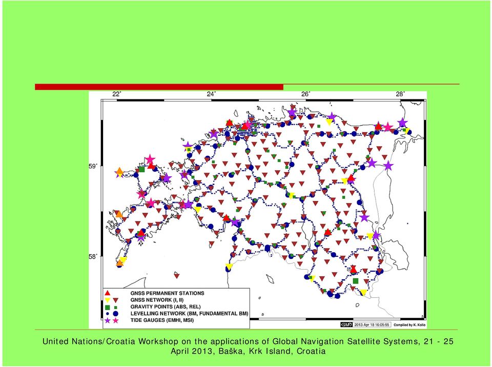
7 Integrated network in Estonia Levelling network Within 1.5 km of the levelling lines 129 RGP points (60%) Gravimetric network From RGP points 56 are situated in a few kilometres range Sea level stations Distances from RGP points 1-12 km

8 GNSS permanent stations with GPS network points

9 GNSS permanent stations with gravimetric network points

10 GNSS permanent stations with levelling network points

11 GNSS permanent stations with tide-gauges

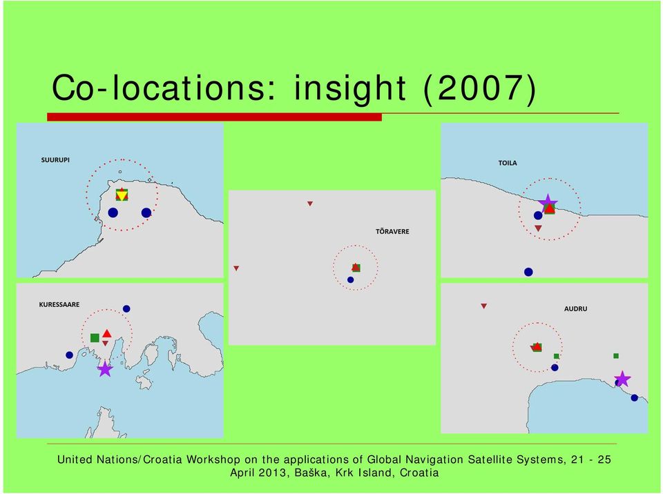
12 Co-locations: insight (2007)
13 Co-locations: insights (2008)

14 Future foresights Several techniques are available in one location In most CORS locations 3 different techniques available Establishment of double CORS stations to monitor the stability Establishment of stations with at least three measurement techniques available

15 References Andres Rüdja: Geodetic datums, reference systems and geodetic networks in Estonia, PhD thesis, Helsinki, 2004 Geodetic Point Database

16 Thank you for your attention!

Case Study Australia. Dr John Dawson A/g Branch Head Geodesy and Seismic Monitoring Geoscience Australia. Chair UN-GGIM-AP WG1 Chair APREF.
 Case Study Australia Dr John Dawson A/g Branch Head Geodesy and Seismic Monitoring Geoscience Australia Chair UN-GGIM-AP WG1 Chair APREF Page 1 Overview 1. Australian height system Australian Height Datum
Evolving a new Geodetic Positioning Framework: An Australian Perspective
 Evolving a new Geodetic Positioning Framework: An Australian Perspective G. Johnston, J. Dawson Outline Introduction Precise Positioning National Geospatial Reference Systems Asia Pacific Reference Frame
Korea Geodetic Framework for Sustainable Development*
 UNITED NATIONS E/CONF.102/IP.17 ECONOMIC AND SOCIAL COUNCIL Nineteenth United Nations Regional Cartographic Conference for Asia and the Pacific Bangkok, 29 October 1 November 2012 Item 6(b) of the provisional
The Map Grid of Australia 1994 A Simplified Computational Manual
 The Map Grid of Australia 1994 A Simplified Computational Manual The Map Grid of Australia 1994 A Simplified Computational Manual 'What's the good of Mercator's North Poles and Equators, Tropics, Zones
WHAT YOU NEED TO USE THE STATE PLANE COORDINATE SYSTEMS
 WHAT YOU NEED TO USE THE STATE PLANE COORDINATE SYSTEMS N & E State Plane Coordinates for Control Points AZIMUTHS - True, Geodetic, or Grid - Conversion from Astronomic to Geodetic (LaPlace Correction)
GGOS Bureau for Networks and Commuications Michael Pearlman Harvard-Smithsonian Center for Astrophysics Cambridge MA USA [email protected].
 GGOS Bureau for Networks and Commuications Michael Pearlman Harvard-Smithsonian Center for Astrophysics Cambridge MA USA [email protected] GGOS Bureau for Networks and Communications Donatello
THE NEED TO IMPLEMENT CONSTRUCTION DEFORMATION SPATIAL MONITORING SYSTEMS IN ROMANIA
 THE NEED TO IMPLEMENT CONSTRUCTION DEFORMATION SPATIAL MONITORING SYSTEMS IN ROMANIA Cristian ONU, Lecturer PhD. Eng., Technical University Gheorghe Asachi of Iasi, Romania, e-mail: [email protected]
The Use and Integrity Monitoring of IGS Products at Geoscience Australia (GA)
") Australian Government Geoscience Australia The Use and Integrity Monitoring of IGS Products at Geoscience Australia (GA) Ramesh Govind, John Dawson, John Manning IGS-2004 Workshop and Symposium Berne,
Australian Government Geoscience Australia The Use and Integrity Monitoring of IGS Products at Geoscience Australia (GA) Ramesh Govind, John Dawson, John Manning IGS-2004 Workshop and Symposium Berne,
Protection of the Environment and Modelling Surface Movements in GIS in the East Slovak Region
 Protection of the Environment and Modelling Surface Movements in GIS in the East Slovak Region Vladimír SEDLÁK, Soňa MOLČÍKOVÁ, Viera HURČÍKOVÁ, Milan FRAJT and Peter MIŠOVIC, Slovakia Key words: 3D deformations,
Günter Seeber. Satellite Geodesy 2nd completely revised and extended edition
 Günter Seeber Satellite Geodesy 2nd completely revised and extended edition Walter de Gruyter Berlin New York 2003 Contents Preface Abbreviations vii xvii 1 Introduction 1 1.1 Subject of Satellite Geodesy...
Development of new hybrid geoid model for Japan, GSIGEO2011. Basara MIYAHARA, Tokuro KODAMA, Yuki KUROISHI
 Development of new hybrid geoid model for Japan, GSIGEO2011 11 Development of new hybrid geoid model for Japan, GSIGEO2011 Basara MIYAHARA, Tokuro KODAMA, Yuki KUROISHI (Published online: 26 December 2014)
Gravity Field Services coordinating global gravity field activities
 Gravity Field Services coordinating global gravity field activities Rene Forsberg National Space Institute (DTU-Space), Denmark Steve Kenyon National Geospatial-Intelligence Agency, USA International Gravity
Status and Development of the European Height Systems
 Status and Development of the European Height Systems J. Adam, W. Augath, F. Brouwer, G. Engelhardt, W. Gurtner, B. G. Harsson, J. IHDE, D. Ineichen, H. Lang, J. Luthardt, M. Sacher, W. Schlüter, T. Springer,
Survey Ties Guidelines
 North Carolina Board of Examiners for Engineers and Surveyors Survey Ties Guidelines The North Carolina Board of Examiners for Engineers and Surveyors is providing this document to serve as an interpretative
Why do we need to improve co-locations of space geodetic techniques?
 Why do we need to improve co-locations of space geodetic techniques? Zuheir Altamimi & Xavier Collilieux IGN France 1 Outline ITRF Heritage Current status of technique networks & co-locations Results from
Tidal Correction Using GPS Determination of the Chart Datum. October 9, FIG Congress 2006
 Tidal Correction Using GPS Determination of the Chart Datum October 9, FIG Congress 2006 Inhalt The Traditional Way of Tide Correction Tide Correction Using GNSS Task I: Realisation of the Chart Datum
The Status of Geospatial Information Management in China
 The Status of Geospatial Information Management in China Submitted by the National Administration of Surveying, Mapping and Geoinformation of China 1. Administration System The National Administration
Towards the Realization of Geo-Referencing Infrastructure for Dynamic Japan (GRID-Japan) Hiromichi TSUJI and Kazuo KOMAKI
 Hiromichi TSUJI and Kazuo KOMAKI") 1 Towards the Realization of Geo-Referencing Infrastructure for Dynamic Japan (GRID-Japan) Hiromichi TSUJI and Kazuo KOMAKI Abstract The recent change of the geodetic reference system of Japan from the
1 Towards the Realization of Geo-Referencing Infrastructure for Dynamic Japan (GRID-Japan) Hiromichi TSUJI and Kazuo KOMAKI Abstract The recent change of the geodetic reference system of Japan from the
Estimates of Future Sea-Level Changes for Norway
 Estimates of Future Sea-Level Changes for Norway March 26, 2012 Matthew Simpson, Kristian Breili, Halfdan Pascal Kierulf, Dagny Lysaker, Mohammed Ouassou and Even Haug Please reference this report as Simpson,
INTEGRATED ANALYSIS OF THE ENVIRONMENTAL MONITORING MEASUREMENTS IN THE GEODYNAMIC TEST NETWORK SÓSKÚT
 PERIODICA POLYTECHNICA SER. CIV. ENG. VOL. 46, NO. 2, PP. 159 168 (2002) INTEGRATED ANALYSIS OF THE ENVIRONMENTAL MONITORING MEASUREMENTS IN THE GEODYNAMIC TEST NETWORK SÓSKÚT József ÁDÁM, László BÁNYAI,
Prof. Ludovico Biagi. Satellite Navigation and Monitoring
 Prof. Ludovico Biagi Satellite Navigation and Monitoring Navigation: trajectories control positions estimations in real time, at high frequency popular applications: low accuracy (10 m) required specific
Survey and Mapping Activities in Vietnam *
 UNITED NATIONS E/CONF.100/CRP.1 ECONOMIC AND SOCIAL COUNCIL Eighteenth United Nations Regional Cartographic Conference for Asia and the Pacific Bangkok, 26-29 October 2009 Item 7(a) of the provisional
Earth Coordinates & Grid Coordinate Systems
 Earth Coordinates & Grid Coordinate Systems How do we model the earth? Datums Datums mathematically describe the surface of the Earth. Accounts for mean sea level, topography, and gravity models. Projections
A guide to coordinate systems in Great Britain
 A guide to coordinate systems in Great Britain An introduction to mapping coordinate systems and the use of GPS datasets with Ordnance Survey mapping D00659 v2.3 Mar 2015 Crown copyright Page 1 of 43 Contents
A New Map of UK Vertical Land Movements based on Continuous GPS and Absolute Gravity
 A New Map of UK Vertical Land Movements based on Continuous GPS and Absolute Gravity Dionne Hansen(Nottingham), Norman Teferle(Nottingham), Richard Bingley(Nottingham) And Simon Williams(POL) EGU2009,
Pacific Sea Level Monitoring Project
 Record 2015/04 GeoCat 82325 Pacific Sea Level Monitoring Project CGPS Coordinate Time Series Analysis Report Jia, M., Dawson, J., Twilley, B. and Hu, G. APPLYING GEOSCIENCE TO AUSTRALIA S MOST IMPORTANT
Guideline for Control Surveys by Differential Levelling
 Guideline for Control Surveys by Differential Levelling Special Publication 1 Intergovernmental Committee on Surveying and Mapping (ICSM) Permanent Committee on Geodesy (PCG) 24 September 2014 Intergovernmental
CHAPTER 9 SURVEYING TERMS AND ABBREVIATIONS
 CHAPTER 9 SURVEYING TERMS AND ABBREVIATIONS Surveying Terms 9-2 Standard Abbreviations 9-6 9-1 A) SURVEYING TERMS Accuracy - The degree of conformity with a standard, or the degree of perfection attained
Congreso Internacional Geomática Andina 2012 4 y 5 de junio, Bogotá, D. C., Colombia
 Claudio Brunini SIRGAS President UNLP - CONICET Argentina Laura Sánchez SIRGAS Vice-President DGFI - Germany William Martínez SIRGAS WGII President IGAC - Colombia María Viriginia Mackern SIRGAS - WGI
The IGS: A Multi-GNSS Service
 The IGS: A Multi-GNSS Service Chris Rizos, Urs Hugentobler, Ruth Neilan IUGG IAG Structure International Union of Geodesy and Geophysics (IUGG) 65 Member Countries (Adhering Bodies), 8 Associations International
United Nations/Azerbaijan/United States of America/ European Space Agency Workshop on the Applications of GNSS
 United Nations/Azerbaijan/United States of America/ European Space Agency Workshop on the Applications of GNSS Baku, May 11-15, 2009 Kyrgyz State University of Construction, Transportation and Architecture
Marlene C.S. Assis. Francisco Colomer. Jesús Gómez-González. José Antonio López-Fernández. Luisa VMS. Moniz. http://www.raege.net/
 Marlene C.S. Assis Francisco Colomer Jesús Gómez-González José Antonio López-Fernández Luisa VMS. Moniz http://www.raege.net/ Instituto Geográfico Nacional Spain Global Geodetic Observing System (GGOS)
European Geodetic Status European Geodetic Reference Systems
 European Geodetic Status European Geodetic Reference Systems Reporter: Hansjörg Kutterer, Federal Agency of Cartography and Geodäsie (BKG), Germany Contributors to this report: Johannes Ihde, Federal Agency
International Gravity Field Service (IGFS)
") IAG Services: International Gravity Field Service (IGFS) 1 International Gravity Field Service (IGFS) http://www.gravityfield.org Chairman: Renè Forsberg (Denmark, 2011-2013) - Riccardo Barzaghi (Italy,
IAG Services: International Gravity Field Service (IGFS) 1 International Gravity Field Service (IGFS) http://www.gravityfield.org Chairman: Renè Forsberg (Denmark, 2011-2013) - Riccardo Barzaghi (Italy,
COLOCATIONS AND MONUMENTATION IN THE DORIS NETWORK
 COLOCATIONS AND MONUMENTATION IN THE DORIS NETWORK Hervé FAGARD (Institut Géographique National - France) 1 H. Fagard (IGN-F) Antenna types in the DORIS permanent network Alcatel Starec 10 stations Deployed
Using GNSS to establish a Height Datum on a Project
 Abstract Richard Stanaway Quickclose PO Box 1364 Carlton VIC 3053 Australia email: [email protected] This paper explains in detail practical steps for establishing or extending a height
GPS Precise Point Positioning as a Method to Evaluate Global TanDEM-X Digital Elevation Model
 GPS Precise Point Positioning as a Method to Evaluate Global TanDEM-X Digital Elevation Model 7 th FIG Regional Conference TS 1C Advances in GNSS Positioning and Applications I Volker Schwieger 1, Jürgen
How To Monitor Sea Level With Satellite Radar
 Satellite Altimetry Wolfgang Bosch Deutsches Geodätisches Forschungsinstitut (DGFI), München email: [email protected] Objectives You shall recognize satellite altimetry as an operational remote sensing
Alfons-Goppel-Str. 11, D-80539 München
 Combination method of different space geodesy techniques for EOP and terrestrial reference frame determination Vojtěch Štefka Alfons-Goppel-Str. 11, D-80539 München Contents: Introduction: ICRS, ITRS and
Trimble CenterPoint RTX Post-Processing Services FAQs
 Trimble CenterPoint RTX Post-Processing Services FAQs What is Trimble RTX technology? 30 September 2013 Trimble RTX TM (Real Time extended) is a high-accuracy, global GNSS correction technology that combines
GNSS and Heighting, Practical Considerations. A Parker National Geo-spatial Information Department of Rural Development and Land Reform
 GNSS and Heighting, Practical Considerations A Parker National Geo-spatial Information Department of Rural Development and Land Reform GNSS Global Navigation Satellite Systems (GNSS) Global Positioning
Perspective of Permanent Reference Network KOPOS in Kosova
 143 Perspective of Permanent Reference Network KOPOS in Kosova Meha, M. and Çaka, M. Kosovo Cadastral Agency, Kosovo Archive Building II nd floor, P.O. 10000, Prishtina, Republic of Kosovo, E-mail: [email protected],
Preliminary Study of Modeling the Precipitable Water Vapor Based on Radiosonde Data
 Preliminary Study of Modeling the Precipitable Water Vapor Based on Radiosonde Data Ilke DENIZ and Cetin MEKIK, Turkey Key words: radiosonde, tropospheric zenith delay, precipitable water vapour SUMMARY
Scheduling of VLBI observations to satellites with the Vienna VLBI Software (VieVS)
") 22 nd EVGA Working Meeting, May 17-21, 2015, Sao Miguel, Pont Delgada, Azores, Portugal Scheduling of VLBI observations to satellites with the Vienna VLBI Software (VieVS) Andreas Hellerschmied 1, J. Böhm
22 nd EVGA Working Meeting, May 17-21, 2015, Sao Miguel, Pont Delgada, Azores, Portugal Scheduling of VLBI observations to satellites with the Vienna VLBI Software (VieVS) Andreas Hellerschmied 1, J. Böhm
COUNTRY REPORT GEOSPATIAL INFORMATION MANAGEMENT IN NEPAL
 COUNTRY REPORT ON GEOSPATIAL INFORMATION MANAGEMENT IN NEPAL Government of Nepal Ministry of Land Reform and Management SURVEY DEPARTMENT PO Box 9435 Min Bhavan, Kathmandu Nepal Tel : + 977 1 4622713 +
Height Datum & Height Determination using GNSS in Singapore
 Height Datum & Height Determination using GNSS in Singapore Dr Victor Khoo Land Survey Division 1 Presenter: 2010 Singapore Land Authority SLA 2015 Singapore 3 2010 Singapore Land Authority Presenter:
GPS LOCATIONS FOR GIS: GETTING THEM RIGHT THE FIRST TIME
 GPS LOCATIONS FOR GIS: GETTING THEM RIGHT THE FIRST TIME Caroline Erickson and Pierre Héroux Geodetic Survey Division, Geomatics Canada Natural Resources Canada 615 Booth Street Ottawa, Ontario K1A 0E9
PLOTTING SURVEYING DATA IN GOOGLE EARTH
 PLOTTING SURVEYING DATA IN GOOGLE EARTH D M STILLMAN Abstract Detail surveys measured with a total station use local coordinate systems. To make the data obtained from such surveys compatible with Google
Geodetic activities in Sweden 2010 2014
 Lantmäterirapport 2015:2 Reports in Geodesy and Geographical Information Systems Geodetic activities in Sweden 2010 2014 Dan Norin, Jan M. Johansson, Stig-Göran Mårtensson, Mehdi Eshagh Gävle 2015 Copyright
Climate and Global Dynamics e-mail: [email protected] National Center for Atmospheric Research phone: (303) 497-1761 Boulder, CO 80307
 497-1761 Boulder, CO 80307") Sean C. Swenson Climate and Global Dynamics P.O. Box 3000 [email protected] National Center for Atmospheric Research (303) 497-1761 Boulder, CO 80307 Education Ph.D. University of Colorado at Boulder,
Sean C. Swenson Climate and Global Dynamics P.O. Box 3000 [email protected] National Center for Atmospheric Research (303) 497-1761 Boulder, CO 80307 Education Ph.D. University of Colorado at Boulder,
AUTOMATED OPERATIONAL MULTI-TRACKING HIGH PRECISION ORBIT DETERMINATION FOR LEO MISSIONS
 AUTOMATED OPERATIONAL MULTI-TRACKING HIGH PRECISION ORBIT DETERMINATION FOR LEO MISSIONS J. Fernández Sánchez, F. M. Martínez Fadrique, A. Águeda Maté, D. Escobar Antón GMV S.A., Isaac Newton 11, 876 Tres
ESTABLISHMENT OF A PERMANENT GPS STATION AT THE DEPARTMENT OF GEODESY AND SURVEYING OF THE BUDAPEST UNIVERSITY OF TECHNOLOGY AND ECONOMICS
 PERIODICA POLYTECHNICA SER. CIV. ENG. VOL. 46, NO. 2, PP. 179 184 (2002) ESTABLISHMENT OF A PERMANENT GPS STATION AT THE DEPARTMENT OF GEODESY AND SURVEYING OF THE BUDAPEST UNIVERSITY OF TECHNOLOGY AND
GEO-SPATIAL-TECHNOLOGIES", a trans-university new integrative master degree
 GEO-SPATIAL-TECHNOLOGIES", a trans-university new integrative master degree Wolfgang Sulzer Institute for Geography and Regional Science University of Graz, Austria Heinrichstrasse 36 A-8010 Graz, Austria
What Does Height Really Mean?
 Department of Natural Resources and the Environment Department of Natural Resources and the Environment Monographs University of Connecticut Year 2007 What Does Height Really Mean? Thomas H. Meyer Daniel
GNSS satellites as co-locations for a combined GNSS and SLR analysis
 GNSS satellites as co-locations for a combined GNSS and SLR analysis D. Thaller 1), K. Sośnica 1), R. Dach 1), A. Jäggi 1), M. Mareyen 2), B. Richter 2), G. Beutler 1) (1) Astronomical Institute, University
SKPOS ( EUPOS ) network solution monitoring application
 network solution monitoring application") S ( EUPOS ) network solution monitoring application Karol Smolík Branislav Droščák, PhD. Geodetic and Cartographic Institute BRATISLAVA [email protected] [email protected] 18 th conference
S ( EUPOS ) network solution monitoring application Karol Smolík Branislav Droščák, PhD. Geodetic and Cartographic Institute BRATISLAVA [email protected] [email protected] 18 th conference
DFS Deutsche Flugsicherung GmbH
 International Symposium on Global Navigation Satellite Systems, Space-based and Ground-based Augmentation Systems and Applications Gabriele Zaki 14.11.2008 Seite 1 Outline Why GBAS How it works DFS Project
High Precision Geoid Determination of Austria Using Heterogeneous Data
 High Precision Geoid Determination of Austria Using Heterogeneous Data Norbert Kühtreiber Department of Positioning and Navigation, Institute of Geodesy, TU-Graz, Steyrergasse 30, A-8010 Graz, Austria
NJDEP GPS Data Collection Standards For GIS Data Development
 NJDEP GPS Data Collection Standards For GIS Data Development Bureau of Geographic Information Systems Office of Information Resource Management June 8, 2011 1.0 Introduction... 3 2.0 GPS Receiver Hardware
Maintaining High Accuracy in Modern Geospatial Data
 Maintaining High Accuracy in Modern Geospatial Data Patrick Cunningham President [email protected] www.bluemarblegeo.com +1 (207) 582 6747 Copyright 2010 Blue Marble Geographics Concepts Geodesy -
THE CURRENT EVOLUTIONS OF THE DORIS SYSTEM
 THE CURRENT EVOLUTIONS OF THE DORIS SYSTEM TAVERNIER, G.; GRANIER, J.P.; JAYLES, C.; SENGENES, P. (CNES) ROZO, F. (COFRAMI) presented by P. VINCENT (CNES) Table of Contents System and Missions Satellites:
Quality of Map-Matching Procedures Based on DGPS and Stand-Alone GPS Positioning in an Urban Area
 Quality of Map-Matching Procedures Based on DGPS and Stand-Alone GPS Positioning in an Urban Area Konstantinos LAKAKIS, Paraskevas SAVVAIDIS, Ioannis M. IFADIS and Ioannis D. DOUKAS, Greece Key words:
International Global Navigation Satellite Systems Service
 International Global Navigation Satellite Systems Service IGS Multi-GNSS Experiment IGS M-GEX Call for Participation www.igs.org Response to this Call for Participation in IGS M-GEX via Web Form Submission
German Antarctic Receiving Station GARS O Higgins: Remote sensing as core for a broader range of activities
 DLR.de Chart 1 > Kathrin Hoeppner > EU-Chile-Workshop > November 28-29, 2013 > Punta Arenas, Chile German Antarctic Receiving Station GARS O Higgins: Remote sensing as core for a broader range of activities
DEGREES OF FREEDOM - SIMPLIFIED
 1 Aust. J. Geod. Photogram. Surv. Nos 46 & 47 December, 1987. pp 57-68 In 009 I retyped this paper and changed symbols eg ˆo σ to VF for my students benefit DEGREES OF FREEDOM - SIMPLIFIED Bruce R. Harvey
Hydrography at IHO cat A level: Scientific Education, at Sea Training, and Interaction with the Industry. N. Debese, R. Moitié, N.
 Hydrography at IHO cat A level: Scientific Education, at Sea Training, and Interaction with the Industry N. Debese, R. Moitié, N. Seube analysis CHC 2010-2 Located in Brest: takes benefits of the French
The Chief Directorate: National
 Surveying The South African Coordinate Reference System (Part 1) by Aslam Parker, Chief Directorate: National Geo-spatial Information This article will define the various elements of the South African
Opus Projects A Web-Based Application to Administer and Process Multi- Day GPS Campaign Data
 Opus Projects A Web-Based Application to Administer and Process Multi- Day GPS Campaign Data Neil D. WESTON, Gerald L. MADER and Tomás SOLER, USA Key words: GPS; Positioning; Campaign SUMMARY The National
Contemporary Education and Quality Assurance in the Geodesy and Geoinformation Programs at the Vienna University of Technology
 204 Vermessung & Geoinformation 1/2009, p. 204 208 Contemporary Education and Quality Assurance in the Geodesy and Geoinformation Programs at the Vienna University of Technology Georg Gartner, Robert Weber,
Adaptation of High Resolution Ikonos Images to Googleearth for Zonguldak Test Field
 Adaptation of High Resolution Ikonos Images to Googleearth for Zonguldak Test Field Umut G. SEFERCIK, Murat ORUC and Mehmet ALKAN, Turkey Key words: Image Processing, Information Content, Image Understanding,
The Status and Development of the APREF GNSS Network Guorong Hu
 The Status and Development of the APREF GNSS Network Guorong Hu Geodesy, Geoscience Australia, Canberra, Australia Outline Introduction Objectives How the reference frame is derived Services and applications
TIDES. 1. Tides are the regular rise and fall of sea level that occurs either once a day (every 24.8 hours) or twice a day (every 12.4 hours).
 or twice a day (every 12.4 hours).") TIDES What causes tides? How are tides predicted? 1. Tides are the regular rise and fall of sea level that occurs either once a day (every 24.8 hours) or twice a day (every 12.4 hours). Tides are waves
TIDES What causes tides? How are tides predicted? 1. Tides are the regular rise and fall of sea level that occurs either once a day (every 24.8 hours) or twice a day (every 12.4 hours). Tides are waves
Enabling RTK-like positioning offshore using the global VERIPOS GNSS network. Pieter Toor GNSS Technology Manager
 Enabling RTK-like positioning offshore using the global VERIPOS GNSS network Pieter Toor GNSS Technology Manager Introduction PPP/RTK Positioning Techniques PPP-AR Technology Presentation Overview PPP-AR
CHAPTER 3 PROJECT CONTROL
 CHAPTER 3 PROJECT CONTROL Marking Survey Control Points 3-2 Horizontal Control 3-2 Vertical Control 3-3 Preconstruction Bench Marks 3-3 Bench Mark Levels 3-3 Bench Mark Check Levels 3-5 Total Station Leveling
量 說 Explanatory Notes on Geodetic Datums in Hong Kong
 量 說 Explanatory Notes on Geodetic Datums in Hong Kong Survey & Mapping Office Lands Department 1995 All Right Reserved by Hong Kong Government 留 CONTENTS INTRODUCTION............... A1 HISTORICAL BACKGROUND............
GPS Data Collection Procedures for Georeferencing Vegetation Resources Inventory and National Forest Inventory Field Sample Plots
 Province of British Columbia GPS Data Collection Procedures for Georeferencing Vegetation Resources Inventory and National Forest Inventory Field Sample Plots Resources Information Branch Ministry of Sustainable
CORS/OPUS: Status & Future Prospects
 CORS/OPUS: Status & Future Prospects Richard Snay, Gerald Mader, & Neil Weston NOAA s National Geodetic Survey CORS Users Forum 44 th CGSIC Meeting Long Beach, CA September 21, 2004 Continuously Operating
Formation and Research in Hydrography Formation et recherche en hydrographie
 Formation and Research in Hydrography Formation et recherche en hydrographie ROCK SANTERRE, Ph.D., QLS, P.Eng. DÉPARTEMENT DES SCIENCES GÉOMATIQUES UNIVERSITÉ LAVAL PRESENTATION OVERVIEW 2 Academic Programs
North American Horizontal Datums. Jan Van Sickle
 North American Horizontal Datums Jan Van Sickle http://www.holoscenes.com/cgi-bin/moin.cgi/easternobliquearc The New England Datum 1879 was the first geodetic datum of this type in the United States. The
Status, Development and Application
 Federal Space Agency GLONASS GLONASS Status, Development and Application Sergey G. Revnivykh International Committee on Global Navigation Satellite Systems (ICG) Second Meeting, September 4-7, 2007, Bangalore,
GEODETIC OPERATIONS IN FINLAND 2004-2007. Edited by Markku Poutanen and Hannu Koivula
 GEODETIC OPERATIONS IN FINLAND 2004-2007 Edited by Markku Poutanen and Hannu Koivula Geodetic Operations in Finland 2004 2007 Edited by Markku Poutanen and Hannu Koivula Finnish Geodetic Institute Kirkkonummi
Marine route optimization. Jens Olaf Pepke Pedersen Polar DTU / DTU Space www.polar.dtu.dk www.space.dtu.dk
 Marine route optimization Jens Olaf Pepke Pedersen Polar DTU / DTU Space www.polar.dtu.dk www.space.dtu.dk Early attempt at route optimization Jens Munk (1579-1628) Tries to find a way to India through
INTRODUCTION TO GNSS NETWORK RTK. BAKU (AZERBAIDJAN) 12 Mai 2009. Ezzedine Djerbi Leica Geo-Systems Switzerland
 12 Mai 2009. Ezzedine Djerbi Leica Geo-Systems Switzerland") INTRODUCTION TO GNSS NETWORK RTK BAKU (AZERBAIDJAN) 12 Mai 2009 Ezzedine Djerbi Leica Geo-Systems Switzerland 1 GPS & GLONASS constellations have never been designed to serve the civilian applications
INTRODUCTION TO GNSS NETWORK RTK BAKU (AZERBAIDJAN) 12 Mai 2009 Ezzedine Djerbi Leica Geo-Systems Switzerland 1 GPS & GLONASS constellations have never been designed to serve the civilian applications
THE ROYAL JORDANIAN GEOGRAPHIC CENTER
 THE ROYAL JORDANIAN GEOGRAPHIC CENTER Outlines: 1- Establishment & Duties 2- Organizational Structure 3- Most Important Achievements 4- Ambitions & Future Vision 2 Establishment & Duties Map Production
3 LEVELLING & SURVEYING
 3 LEVELLING & SURVEYING 3.1 General The primary reference at water-level recording stations is a set of stable bench-marks, installed in locations where their level should not change. Upon initial set-up