NetCDF and HDF Data in ArcGIS
|
|
|
- Nickolas Cannon
- 10 years ago
- Views:
Transcription
1 2013 Esri International User Conference July 8 12, 2013 San Diego, California Technical Workshop NetCDF and HDF Data in ArcGIS Nawajish Noman Kevin Butler Esri UC2013. Technical Workshop.

2 Outline NetCDF and HDF in ArcGIS - Demo 1 Visualization and Analysis - Demo 2 Customization using Python - Demo 3 Future Directions

3 Scientific Data and Esri Direct support - NetCDF and HDF THREDDS/OPeNDAP a framework for scientific data networking, integrated use by our customers Examples using Esri technology - National Climate Data Center - National Weather Service - National Center for Atmospheric Research - U. S. Navy (NAVO) - Air Force Weather - Australian Navy - Australian Bur.of Met. - UK Met Office
 - Air Force Weather - Australian Navy - Australian Bur.of Met.")
4 NetCDF Support in ArcGIS ArcGIS reads/writes netcdf since version 9.2 An array based data structure for storing multidimensional data. T N-dimensional coordinates systems X, Y, Z, time, and other dimensions Z Y Variables support for multiple variables Temperature, humidity, pressure, salinity, etc X Geometry implicit or explicit Regular grid (implicit) Irregular grid Points

5 Gridded Data Regular Grid Irregular Grid

6 Reading netcdf data in ArcGIS NetCDF data is accessed as Raster Feature Table Direct read Exports GIS data to netcdf

7 CF Convention

8 NetCDF and Coordinate Systems Geographic Coordinate Systems (GCS) X dimension units: degrees_east Y dimension units: degrees_north Projected Coordinate Systems (PCS) X dimension standard_name: projection_x_coordinate Y dimension standard_name: projection_y_coordinate Variable has a grid_mapping attribute. CF 1.6 conventions currently supports thirteen predefined coordinate systems (Appendix F: Grid Mappings) Undefined If not GCS or PCS ArcGIS writes (and recognizes) PE String as a variable attribute.
 Undefined If not GCS or")
9 NetCDF Tools Toolbox: Multidimension Tools Make NetCDF Raster Layer Make NetCDF Feature Layer Make NetCDF Table View Raster to NetCDF Feature to NetCDF Table to NetCDF Select by Dimension

10 NetCDF Layer/Table Properties Raster Feature Table

11 Changing Time Slice Y Time Time = X

12 Reading HDF in ArcGIS

13 Raster Concepts Raster Format (e.g. img, tif, etc.) - driver level support / storage format and layout / read/write of pixels and metadata Raster Type (e.g. GeoEye-1) - implies Raster Format support and are format and sensor specific - intelligent use of metadata and other sensor specific parameters - defines georeferencing and well known processing chains Raster Product (e.g. Panchromatic, Multispectral, Pansharpened ) - templates which make it easy to work with well defined end user products - multiple per sensor - e.g. Panchromatic, Multispectral, Pansharpened Raster Product Definition (e.g. Natural Color, False Color) - defines how you want your Mosaic Dataset to look regardless of multiple source sensors and band combinations - uses metadata such as wavelength information to map bands
 - defines how you want your Mosaic Dataset to look regardless of multiple source sensors and")
14 HDF Raster Support Raster Concept Raster Format Raster Type Raster Product Raster Product Definition ArcGIS 10.1 Support HDF4 read: open a HDF subdataset as a Raster Dataset write: APIs available but not exposed in UI HDF5 read: open a HDF subdataset as a Raster Dataset write: not supported at this time HDF4, HDF5 direct ingest of one or many HDF subdatasets into a Mosaic Dataset using the Raster Dataset Raster Type or the Table Raster Type * Esri interested in discussing other Raster Types * Esri interested in discussing other Raster Products * Esri interested in discussing other Raster Product Definitions

15 HDF Raster Support 10.1 Raster Format and Raster Type support implies - ArcGIS Desktop - direct use as a Raster Dataset or Mosaic Dataset - use via conversion (i.e. convert to another format) - feature rich use in the applications - Visualization and Mapping - Geoprocessing - ArcGIS Server - publishing as dynamic image services - caching and publishing as tile services (i.e. basemaps) - OGC (WCS, WMS, WMTS)

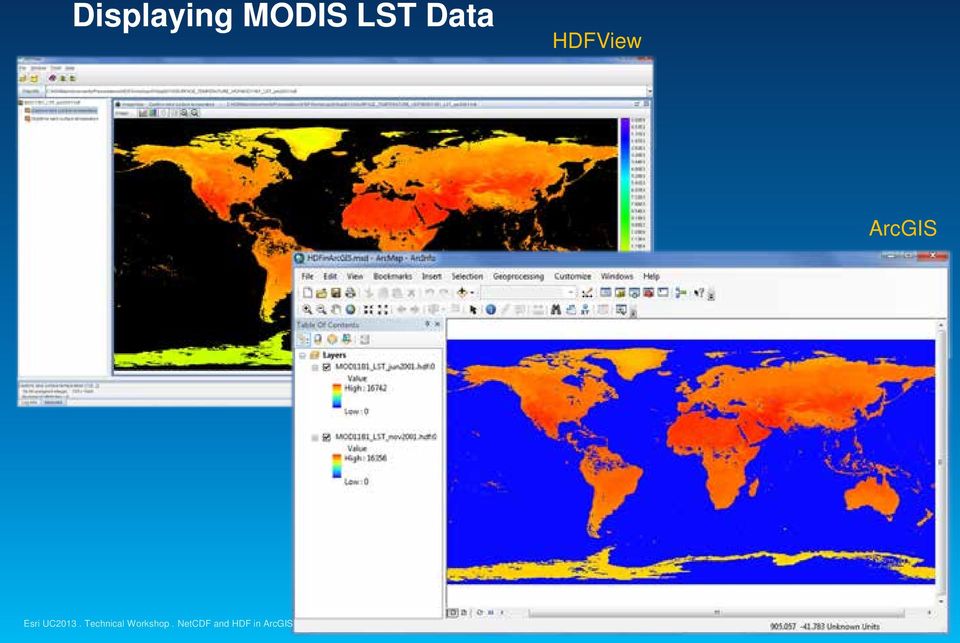
16 Displaying MODIS LST Data HDFView ArcGIS
17 Demo: Reading netcdf and HDF data Esri UC2013. Technical Workshop.

18 Using netcdf Data Behaves the same as any layer or table Display Same display tools for raster and feature layers will work on netcdf raster and netcdf feature layers. Graphing Driven by the table just like any other chart. Animation Multidimensional data can be animated through a dimension (e.g. time, pressure, elevation) Analysis Tools A netcdf layer or table will work just like any other raster layer, feature layer, or table. (e.g. create buffers around netcdf points, reproject rasters, query tables, etc.)

19 Time in ArcGIS Simple Temporal Mapping Unified experience for Time Configure time properties on the layer Use Time Slider to visualize temporal data Share temporal visualization Time-enabled Map Services Export videos or images Generate temporal map books using ArcPy scripting Layer and map packages

20 Animation Examples 1979

21 Spatial and Temporal Analysis Several hundreds analytical tools available for raster, features, and table Temporal Modeling Looping and iteration in ModelBuilder and Python
22 Generate Rainfall Statistics Calculates specified statistics for all time steps Outputs a raster catalog Optionally outputs a netcdf file
23 Generate Rainfall Statistics Table Calculates statistics for all time steps Outputs a table Optionally creates a graph
24 Demo: Animation and Analysis Esri UC2013. Technical Workshop.
25 Community Developed Tools Geoprocessing Resource Center Marine Geospatial Ecology Tools (MGET) Developed at Duke Univ. Over 180 tools for import management, and analysis of marine data Australian Navy tools (not publicly available)
26 Script Tools Python is used to build custom tools for specific tasks or datasets
27 New Multidimension Tools OPeNDAP to NetCDF Make NetCDF Regular Point Layer Make NetCDF Station Point Layer Make NetCDF Trajectory Point Layer Describe Multidimensional Dataset Get Variable Statistics Get Variable Statistics Over Dimension Multidimensional Zonal Statistics Multidimensional Zonal Statistics As Table
28 OPeNDAP to NetCDF
29 Reading Features from a netcdf File
30 Dependencies on 3 rd Party Utilities netcdf4-python This module can read and write files in both the new netcdf 4 and the old netcdf 3 format, and can create files that are readable by HDF5 clients. Pydap Pydap is a pure Python library implementing the Data Access Protocol, also known as DODS or OPeNDAP. OWSLib OWSLib (OGC Web Service utility library) Package for working with OGC map, feature, and coverage services. OWSLib provides a common API for accessing service metadata and wrappers for GetCapabilities, GetMap, and GetFeature requests.
31 Demo: Workflow and Customization Esri UC2013. Technical Workshop.
32 HDF and Swath
33 Future Initiatives Ongoing efforts - require close collaboration with all of you Some of the future initiatives are: Continue to support netcdf classic and netcdf4 Provide better support for HDF5 Provide tool to consume data served using THREDDS/OPeNDAP Continue to support the evolving CF convention Support a strong developer experience for netcdf and HDF using Python What else?
34 Things to Consider Embrace the Common Data Model (netcdf, HDF etc.) Use Data and metadata standards (OGC, CF etc) Provide mechanism so that we can access scientific data using a single set of APIs. and can expect data to be CF complainant Make your data spatial (by specifying geographic or a projected coordinate system) Clearly define workflow and requirements Create sample tools where possible
35 Thank you Please fill out the session evaluation Offering ID: 1365 Online Paper pick up and put in drop box
36
Scientific Data Management and Dissemination
 Federal GIS Conference February 9 10, 2015 Washington, DC Scientific Data Management and Dissemination John Fry Solution Engineer, Esri [email protected] Agenda Background of Scientific Data Management through
PART 1. Representations of atmospheric phenomena
 PART 1 Representations of atmospheric phenomena Atmospheric data meet all of the criteria for big data : they are large (high volume), generated or captured frequently (high velocity), and represent a
Advanced Image Management using the Mosaic Dataset
 Esri International User Conference San Diego, California Technical Workshops July 25, 2012 Advanced Image Management using the Mosaic Dataset Vinay Viswambharan, Mike Muller Agenda ArcGIS Image Management
Working with Temporal Data
 Esri International User Conference San Diego, California Technical Workshops July 26 2012 Working with Temporal Data Aileen Buckley Mark Smithgall This technical workshop Visualizing temporal data recurring
What's new in gvsig Desktop 2.0
 What's new in gvsig Desktop 2.0 What are the novelties? 2.0 1.12 Migrating and building... Some examples... Please pardon our appearance during construction Pie and bar chart legends Table in layout 1.12
INTEROPERABLE IMAGE DATA ACCESS THROUGH ARCGIS SERVER
 INTEROPERABLE IMAGE DATA ACCESS THROUGH ARCGIS SERVER Qian Liu Environmental Systems Research Institute 380 New York Street Redlands, CA92373, U.S.A - [email protected] KEY WORDS: OGC, Standard, Interoperability,
Open Source Visualisation with ADAGUC Web Map Services
 Open Source Visualisation with ADAGUC Web Map Services Maarten Plieger Ernst de Vreede John van de Vegte, Wim Som de Cerff, Raymond Sluiter, Ian van der Neut, Jan Willem Noteboom 1 ADAGUC project Cooperative
ArcGIS Viewer for Silverlight An Introduction
 Esri International User Conference San Diego, California Technical Workshops July 26, 2012 ArcGIS Viewer for Silverlight An Introduction Rich Zwaap Agenda Background Product overview Getting started and
Using CAD Data in ArcGIS
 Esri International User Conference San Diego, California Technical Workshops July 27, 2012 Using CAD Data in ArcGIS Jeff Reinhart & Phil Sanchez Agenda Overview of ArcGIS CAD Support Using CAD Datasets
Introduction to Imagery and Raster Data in ArcGIS
 Esri International User Conference San Diego, California Technical Workshops July 25, 2012 Introduction to Imagery and Raster Data in ArcGIS Simon Woo slides Cody Benkelman - demos Overview of Presentation
Enterprise Image Management. An Esri White Paper November 2015
 An Esri White Paper November 2015 Copyright 2015 Esri All rights reserved. Printed in the United States of America. The information contained in this document is the exclusive property of Esri. This work
Visualizing Multi-Dimensional WMS within ArcGIS For JavaScript API
 Visualizing Multi-Dimensional WMS within ArcGIS For JavaScript API Data Prep: 1. Obtain a netcdf File with a time dimension and another dimension. For example depth, altitude 2. Open ArcGIS Desktop 3.
Supporting High-Quality Printing in Web Applications with ArcGIS for Server
 2013 Esri International User Conference July 8 12, 2013 San Diego, California Technical Workshop Supporting High-Quality Printing in Web Applications with ArcGIS for Server Craig Williams Tanu Hoque Esri
Managing Bathymetry in the Cloud with GIS
 Esri Maritime Professional Services GEBCO Science Day Tuesday, October 4, 2011 Managing Bathymetry in the Cloud with GIS Timothy Kearns & Beata Van Esch Overview The challenges of bathymetry in GIS - What
What is GIS. What is GIS? University of Tsukuba. What do you image of GIS? Copyright(C) ESRI Japan Corporation. All rights reserved.
 ESRI Japan Corporation. All rights reserved.") What is GIS University of Tsukuba Graduate School of Life and Environmental Science April 21 st, 2011 What is GIS? What do you image of GIS? Gas Insulated Switch Groupe Interventional Speciale Geographic
What is GIS University of Tsukuba Graduate School of Life and Environmental Science April 21 st, 2011 What is GIS? What do you image of GIS? Gas Insulated Switch Groupe Interventional Speciale Geographic
GIS Initiative: Developing an atmospheric data model for GIS. Olga Wilhelmi (ESIG), Jennifer Boehnert (RAP/ESIG) and Terri Betancourt (RAP)
, Jennifer Boehnert (RAP/ESIG) and Terri Betancourt (RAP)") GIS Initiative: Developing an atmospheric data model for GIS Olga Wilhelmi (ESIG), Jennifer Boehnert (RAP/ESIG) and Terri Betancourt (RAP) Unidata seminar August 30, 2004 Presentation Outline Overview
GIS Initiative: Developing an atmospheric data model for GIS Olga Wilhelmi (ESIG), Jennifer Boehnert (RAP/ESIG) and Terri Betancourt (RAP) Unidata seminar August 30, 2004 Presentation Outline Overview
How To Write An Nccwsc/Csc Data Management Plan
 Guidance and Requirements for NCCWSC/CSC Plans (Required for NCCWSC and CSC Proposals and Funded Projects) Prepared by the CSC/NCCWSC Working Group Emily Fort, Data and IT Manager for the National Climate
ArcGIS ArcMap: Printing, Exporting, and ArcPress
 Esri International User Conference San Diego, California Technical Workshops July 25th, 2012 ArcGIS ArcMap: Printing, Exporting, and ArcPress Michael Grossman Jeremy Wright Workshop Overview Output in
Leveraging Image Services in JavaScript/HTML5 Applications. Wenxue Ju, Hong Xu
 Leveraging Image Services in JavaScript/HTML5 Applications Wenxue Ju, Hong Xu Schedule Image service introduction Web applications with image services - Server side image processing - Client side image
Application Development Using Image Services Web APIs. Hong Xu, Wenxue Ju
 Application Development Using Image Services Web APIs Hong Xu, Wenxue Ju Session Outline Discuss and demonstrate the following image service web application patterns: Display image service in your web
OGC at KNMI: Current use and plans Available products
 OGC at KNMI: Current use and plans Available products Maarten Plieger KNMI R&D Ernst de Vreede, John van de Vegte, Wim Som de Cerff, Ian van der Neut, Raymond Sluiter, Jan Willem Noteboom Contents 1. ADAGUC
ArcGIS. Server. A Complete and Integrated Server GIS
 ArcGIS Server A Complete and Integrated Server GIS ArcGIS Server A Complete and Integrated Server GIS ArcGIS Server enables you to distribute maps, models, and tools to others within your organization
Big Data Spatial Analytics An Introduction
 2013 Esri International User Conference July 8 12, 2013 San Diego, California Technical Workshop Big Data Spatial Analytics An Introduction Marwa Mabrouk Mansour Raad Esri iu UC2013. Technical Workshop
SUMMER SCHOOL ON ADVANCES IN GIS
 SUMMER SCHOOL ON ADVANCES IN GIS Six Workshops Overview The workshop sequence at the UMD Center for Geospatial Information Science is designed to provide a comprehensive overview of current state-of-the-art
The Courses. Covering complete breadth of GIS technology from ESRI including ArcGIS, ArcGIS Server and ArcGIS Engine.
 ESRI India: Corporate profile ESRI India A profile India s Premier GIS Company Strategic alliance between ESRI Inc. and NIIT Technologies Adjudged as India s Best GIS Solutions Company - Map India 2001
NetCDF Tutorial. Copyright 1995-2010 Esri All rights reserved.
 Copyright 1995-2010 Esri All rights reserved. Table of Contents About the netcdf Tutorial............................... 3 Exercise 1: Displaying a raster layer from a netcdf file................... 4
Vision. South Pacific GIS/RS Conference 2015 11/17/2015. Applying Geography Everywhere. Applying Geography Everywhere
 South Pacific GIS/RS Conference 2015 Applying Geography Everywhere Jithen (J) Singh Eagle Technology Group Ltd (Esri New Zealand) Suva, Fiji Vision Applying Geography Everywhere 1 GIS Is Evolving A Whole
The Arctic Observing Network and its Data Management Challenges Florence Fetterer (NSIDC/CIRES/CU), James A. Moore (NCAR/EOL), and the CADIS team
, James A. Moore (NCAR/EOL), and the CADIS team") The Arctic Observing Network and its Data Management Challenges Florence Fetterer (NSIDC/CIRES/CU), James A. Moore (NCAR/EOL), and the CADIS team Photo courtesy Andrew Mahoney NSF Vision What is AON? a
The Arctic Observing Network and its Data Management Challenges Florence Fetterer (NSIDC/CIRES/CU), James A. Moore (NCAR/EOL), and the CADIS team Photo courtesy Andrew Mahoney NSF Vision What is AON? a
13.2 THE INTEGRATED DATA VIEWER A WEB-ENABLED APPLICATION FOR SCIENTIFIC ANALYSIS AND VISUALIZATION
 13.2 THE INTEGRATED DATA VIEWER A WEB-ENABLED APPLICATION FOR SCIENTIFIC ANALYSIS AND VISUALIZATION Don Murray*, Jeff McWhirter, Stuart Wier, Steve Emmerson Unidata Program Center, Boulder, Colorado 1.
Jozef Matula. Visualisation Team Leader IBL Software Engineering. 13 th ECMWF MetOps Workshop, 31 th Oct - 4 th Nov 2011, Reading, United Kingdom
 Visual Weather web services Jozef Matula Visualisation Team Leader IBL Software Engineering Outline Visual Weather in a nutshell. Path from Visual Weather (as meteorological workstation) to Web Server
How To Use Gis
 Welcome Understanding Purpose Creating Relationships You A Global Community of GIS Professionals Changing the World Together Applying Geography Everywhere Your WORK Showcasing Your Web Apps Vision Applying
Network Analysis with Python. Deelesh Mandloi
 Deelesh Mandloi Slides and code samples from this demo theater http://esriurl.com/uc15nawpy Topics ArcGIS Network Analyst extension and concepts Network analysis using ArcGIS Online Network analysis using
ENVI THE PREMIER SOFTWARE FOR EXTRACTING INFORMATION FROM GEOSPATIAL IMAGERY.
 ENVI THE PREMIER SOFTWARE FOR EXTRACTING INFORMATION FROM GEOSPATIAL IMAGERY. ENVI Imagery Becomes Knowledge ENVI software uses proven scientific methods and automated processes to help you turn geospatial
Managing Imagery and Raster Data in ArcGIS
 Technical Workshops Managing Imagery and Raster Data in ArcGIS Hong Xu, Sangeet Mathew, Mark Harris Presentation Overview ArcGIS raster data models Which model to use Mosaic dataset storage and properties
Note: Hands On workshops are Bring Your Own Laptop (BYOL), unless otherwise noted. Some workshops are Bring Your Own Mobile Device(BYOD).
, unless otherwise noted. Some workshops are Bring Your Own Mobile Device(BYOD).") 2015 MN GIS/LIS Consortium Pre Conference Workshops The Minnesota GIS/LIS Consortium is pleased to offer a diverse list of workshops on Wednesday, October 7th, 2015 at the DECC, Duluth, Minnesota Charting
2015 MN GIS/LIS Consortium Pre Conference Workshops The Minnesota GIS/LIS Consortium is pleased to offer a diverse list of workshops on Wednesday, October 7th, 2015 at the DECC, Duluth, Minnesota Charting
Esri Maps for Salesforce and Microsoft Dynamics CRM
 Esri Maps for Salesforce and Microsoft Dynamics CRM Daniel Lee, Lucy Guerra Esri UC 2014 Technical Workshop Agenda CRM and Esri Esri Maps for Demos Road Ahead Esri UC 2014 Technical Workshop Esri Maps
ESRI Technical Certification Overview. Amy Daniels Instructor, Greenville Tech
 ESRI Technical Certification Overview Amy Daniels Instructor, Greenville Tech Why have certification by ESRI? It communicates your proficiency in ESRI software Similar to Microsoft Certification, it can
The premier software for extracting information from geospatial imagery.
 Imagery Becomes Knowledge ENVI The premier software for extracting information from geospatial imagery. ENVI Imagery Becomes Knowledge Geospatial imagery is used more and more across industries because
The ORIENTGATE data platform
 Seminar on Proposed and Revised set of indicators June 4-5, 2014 - Belgrade (Serbia) The ORIENTGATE data platform WP2, Action 2.4 Alessandra Nuzzo, Sandro Fiore, Giovanni Aloisio Scientific Computing and
Institute of Computational Modeling SB RAS
 Institute of Computational Modeling SB RAS ORGANIZATION OF ACCESS TO OBSERVATIONAL DATA USING WEB SERVICES FOR MONITORING SYSTEMS THE STATE OF THE ENVIRONMENT Kadochnikov Aleksey A. Russia, Krasnoyarsk
Esri Maps for Office, SharePoint & Dynamics CRM. Tony Howser Sentha Sivabalan Scott Ball
 Esri Maps for Office, SharePoint & Dynamics CRM Tony Howser Sentha Sivabalan Scott Ball Agenda Location Analytics Esri Maps for - SharePoint - Office - Dynamics CRM Pricing Road Map Q & A Evolving the
CLOUD BASED N-DIMENSIONAL WEATHER FORECAST VISUALIZATION TOOL WITH IMAGE ANALYSIS CAPABILITIES
 CLOUD BASED N-DIMENSIONAL WEATHER FORECAST VISUALIZATION TOOL WITH IMAGE ANALYSIS CAPABILITIES M. Laka-Iñurrategi a, I. Alberdi a, K. Alonso b, M. Quartulli a a Vicomteh-IK4, Mikeletegi pasealekua 57,
GIS Databases With focused on ArcSDE
 Linköpings universitet / IDA / Div. for human-centered systems GIS Databases With focused on ArcSDE Imad Abugessaisa [email protected] 20071004 1 GIS and SDBMS Geographical data is spatial data whose
ArcGIS for Server: Administrative Scripting and Automation
 ArcGIS for Server: Administrative Scripting and Automation Shreyas Shinde Ranjit Iyer Esri UC 2014 Technical Workshop Agenda Introduction to server administration Command line tools ArcGIS Server Manager
Oklahoma s Open Source Spatial Data Clearinghouse: OKMaps
 Oklahoma s Open Source Spatial Data Clearinghouse: OKMaps Presented by: Mike Sharp State Geographic Information Coordinator Oklahoma Office of Geographic Information MAGIC 2014 Symposium April 28-May1,
ArcGIS Server 9.3.1 mashups
 Welcome to ArcGIS Server 9.3.1: Creating Fast Web Mapping Applications With JavaScript Scott Moore ESRI Olympia, WA [email protected] Seminar agenda ArcGIS API for JavaScript: An Overview ArcGIS Server Resource
ArcGIS. Image Server tutorial
 ArcGIS 9 ArcGIS Image Server tutorial Copyright 2006, 2007, and 2008 Zanja Technologies, Inc. All rights reserved. The information contained in this work is the property of Zanja Technologies, Inc., under
Multidimensional Marine Environmental Data Conversion and Visualization Using Python and GIS
 386 Multidimensional Marine Environmental Data Conversion and Visualization Using Python and GIS Manuel RAINER Abstract The Tropical Marine Science Institute (TMSI) at the National University of Singapore
Version 3.0, April 16, 2012, updated for ArcGIS 10.0 Produced by the Geographic Information Network of Alaska http://www.gina.alaska.
 Using the AlaskaMapped Web Services in ESRI ArcGIS Version 3.0, April 16, 2012, updated for ArcGIS 10.0 Produced by the Geographic Information Network of Alaska http://www.gina.alaska.edu AlaskaMapped
Web and Mobile GIS Applications Development
 Web and Mobile GIS Applications Development Presented by : Aamir Ali Manager Section Head (GIS Software Customization) Pakistan Space and Upper Atmosphere Research Commission (SUPARCO) Geographical Information
Harvard Data Visualization Project
 Esri User Conference, July 12-15, San Diego California Harvard Data Visualization Project Spatio-Temporal Visualization of Global Phenomena: 1850 to the Present Harvard Business School Geoffrey Jones Walter
Portal. from the trenches!
 from the trenches! Deployment Patterns Scaling and High Availability Reference Implementations Common Challenges Extending Engagement patterns Esri UC 2014 Technical Workshop for ArcGIS Technology Transfer
Choosing the right GIS framework for an informed Enterprise Web GIS Solution
 13 ANNUAL INTERNATIONAL CONFERENCE AND EXHIBITION ON GEOSPATIAL INFORMATION TECHNOLOGY AND APPLICATIONS Epicentre; Gurgaon, India; 19-21 January, 2010 Choosing the right GIS framework for an informed Enterprise
Model examples Store and provide Challenges WCS and OPeNDAP Recommendations. WCS versus OPeNDAP. Making model results available through the internet.
 Making model results available through the internet. Fedor Baart, Gerben de Boer, Wim de Haas, Gennadiy Donchyts, Marc Philippart, Maarten Plieger September 14, 2011 Introduction Fedor Baart PhD thesis:
Building Applications with the ArcGIS Runtime SDK for Windows Mobile
 Esri International User Conference San Diego, California Technical Workshops July 25th Building Applications with the ArcGIS Runtime SDK for Windows Mobile Jay Chen Justin Colville What we will cover today
REACCH PNA Data Management Plan
 REACCH PNA Data Management Plan Regional Approaches to Climate Change (REACCH) For Pacific Northwest Agriculture 875 Perimeter Drive MS 2339 Moscow, ID 83844-2339 http://www.reacchpna.org [email protected]
EUMETSAT EO Portal. End User Image Access using OGC WMS/WCS services. EUM/OPS/VWG/10/0095 Issue <1> <14/01/2010> Slide: 1
 EUMETSAT EO Portal End User Image Access using OGC WMS/WCS services Slide: 1 Overview Introduction: status of data access and visualization EUMETSAT datasets Architecture Web Map Service implementation
Big Data Volume & velocity data management with ERDAS APOLLO. Alain Kabamba Hexagon Geospatial
 Big Data Volume & velocity data management with ERDAS APOLLO Alain Kabamba Hexagon Geospatial Intergraph is Part of the Hexagon Family Hexagon is dedicated to delivering actionable information through
Supporting High-Quality Printing in Web Applications with ArcGIS 10.1 for Server
 Esri International User Conference San Diego, California Technical Workshops July 25, 2012 Supporting High-Quality Printing in Web Applications with ArcGIS 10.1 for Server Craig Williams and Tanu Hoque
ArcGIS Platform. An Integrated System. Portal
 Platform An Integrated System Portal An Integrated Web GIS Platform Knowledge Workers Executive Access Public Engagement Work Anywhere Enterprise Integration Providing Mapping, Analysis, Data Management,
Keystone Image Management System
 Image management solutions for satellite and airborne sensors Overview The Keystone Image Management System offers solutions that archive, catalogue, process and deliver digital images from a vast number
J9.6 GIS TOOLS FOR VISUALIZATION AND ANALYSIS OF NEXRAD RADAR (WSR-88D) ARCHIVED DATA AT THE NATIONAL CLIMATIC DATA CENTER
 ARCHIVED DATA AT THE NATIONAL CLIMATIC DATA CENTER") J9.6 GIS TOOLS FOR VISUALIZATION AND ANALYSIS OF RADAR (WSR-88D) ARCHIVED DATA AT THE NATIONAL CLIMATIC DATA CENTER Steve Ansari * STG Incorporated, Asheville, North Carolina Stephen Del Greco NOAA National
J9.6 GIS TOOLS FOR VISUALIZATION AND ANALYSIS OF RADAR (WSR-88D) ARCHIVED DATA AT THE NATIONAL CLIMATIC DATA CENTER Steve Ansari * STG Incorporated, Asheville, North Carolina Stephen Del Greco NOAA National
Investigating Hadoop for Large Spatiotemporal Processing Tasks
 Investigating Hadoop for Large Spatiotemporal Processing Tasks David Strohschein [email protected] Stephen Mcdonald [email protected] Benjamin Lewis [email protected] Weihe
Standardized data sharing through an open-source Spatial Data Infrastructure: the Afromaison project
 Standardized data sharing through an open-source Spatial Data Infrastructure: the Afromaison project Yaniss Guigoz - University of Geneva/GRID-Geneva 1 EcoARM2ERA and AFROMAISON Why Afromaison in this
GeoMedia Product Update. Title of Presentation. Lorilie Barteski October 15, 2008 Edmonton, AB
 Product Update Title of Presentation Lorilie Barteski Edmonton, AB Know the audience poll Existing /Pro users Version 6.1 Version 6.0 Version 5.2 or earlier Existing WebMap users Version 6.1 Version 6.0
Norwegian Satellite Earth Observation Database for Marine and Polar Research http://normap.nersc.no USE CASES
 Norwegian Satellite Earth Observation Database for Marine and Polar Research http://normap.nersc.no USE CASES The NORMAP Project team has prepared this document to present functionality of the NORMAP portal.
Geospatial exploitation Products. GXP WebView. Powered by the GXP Platform
 Geospatial exploitation Products GXP WebView Powered by the GXP Platform Exploitation Capabilities GXP WebView Powered by the GXP Platform Detailed annotation (text, points, lines, and polygons) Distance,
VISUAL INSPECTION OF EO DATA AND PRODUCTS - OVERVIEW
 WMS services from the EUMETSAT real-time Image Gallery Uwe Voges (1), Michael Schick (2), Udo Einspanier (1) (1) con terra GmbH Martin-Luther-King-Weg 24, 48155, Münster, Germany EMail: (U.Voges U.Einspanier)@conterra.de
Publishing Geoprocessing Services Tutorial
 Publishing Geoprocessing Services Tutorial Copyright 1995-2010 Esri All rights reserved. Table of Contents Tutorial: Publishing a geoprocessing service........................ 3 Copyright 1995-2010 ESRI,
Basic GIS Modeling: Improving Campus Maintenance, Management, and Planning August 8 th, 2007. Matt Davis [email protected]
 NCFMTC- Modeling Your Campus Basic GIS Modeling: Improving Campus Maintenance, Management, and Planning August 8 th, 2007 Matt Davis [email protected] 1 Abstract Basic GIS Modeling: Improving Campus Maintenance,
LSA SAF products: files and formats
 LSA SAF products: files and formats Carla Barroso, IPMA Application of Remote Sensing Data for Drought Monitoring Introduction to Eumetsat LANDSAF Products 11-15 November Slovenia OUTLINE Where to get
ArcGIS 10.1 Geodatabase Administration. Gordon Sumerling & Christopher Brown
 ArcGIS 10.1 Geodatabase Administration Gordon Sumerling & Christopher Brown Key Improvements at ArcGIS 10.1 1. Easier Administration through Graphic Interfaces 2. Greater Seamless integration with Open
Cloud-based Geospatial Data services and analysis
 Cloud-based Geospatial Data services and analysis Xuezhi Wang Scientific Data Center Computer Network Information Center Chinese Academy of Sciences 2014-08-25 Outlines 1 Introduction of Geospatial Data
Esri Maps for Business Intelligence (BI)
") 2013 Esri International User Conference July 8 12, 2013 San Diego, California Technical Workshop Esri Maps for Business Intelligence (BI) Pierre Seguin Patrick Brennan Esri UC2013. Technical Workshop.
2013 Esri International User Conference July 8 12, 2013 San Diego, California Technical Workshop Esri Maps for Business Intelligence (BI) Pierre Seguin Patrick Brennan Esri UC2013. Technical Workshop.
Structure? Integrated Climate Data Center How to use the ICDC? Tools? Data Formats? User
 Integrated Climate Data Center? Data Formats?? Tools???? visits Structure???? User Contents Which Data Formats do we offer? What is the Structure of our data center? Which Tools do we provide? Our Aims
Data Visualization Using Web GIS Software
 Data Visualization Using Web GIS Software Tuomas Peltonen Radiation and Nuclear Safety Authority (STUK), Finland NKS NordDSS Workshop, Copenhagen, 1.-2.10.2009 RADIATION AND NUCLEAR SAFETY AUTHORITY Preface
WCS as a Download Service for Big (and Small) Data
 Data") WCS as a Download Service for Big (and Small) Data INSPIRE 2013 Florence, Italy, 2013-jun-25 Peter Baumann 1, Stephan Meissl 2, Alan Beccati 1 1 Jacobs University rasdaman GmbH, Bremen, Germany 2 EOX GmbH,
WCS as a Download Service for Big (and Small) Data INSPIRE 2013 Florence, Italy, 2013-jun-25 Peter Baumann 1, Stephan Meissl 2, Alan Beccati 1 1 Jacobs University rasdaman GmbH, Bremen, Germany 2 EOX GmbH,
NATIONAL CLIMATE CHANGE & WILDLIFE SCIENCE CENTER & CLIMATE SCIENCE CENTERS DATA MANAGEMENT PLAN GUIDANCE
 NATIONAL CLIMATE CHANGE & WILDLIFE SCIENCE CENTER & CLIMATE SCIENCE CENTERS DATA MANAGEMENT PLAN GUIDANCE Prepared by: NCCWSC/CSC Data Management Working Group US Geological Survey February 26, 2013 Version
An Introduction to Open Source Geospatial Tools
 An Introduction to Open Source Geospatial Tools by Tyler Mitchell, author of Web Mapping Illustrated GRSS would like to thank Mr. Mitchell for this tutorial. Geospatial technologies come in many forms,
About As. In a team with the best. ESRI Bulgaria is the exclusive distributor of Esri Inc. for Bulgaria. Esri Inc.
 About As ESRI Bulgaria is an IT company, leader in the field of Geographic Information Systems (GIS) on the Bulgarian market. Offering the most advanced high-tech products, solutions and services, ESRI
Managing Lidar (and other point cloud) Data. Lindsay Weitz Cody Benkelman
 Data. Lindsay Weitz Cody Benkelman") (and other point cloud) Data Lindsay Weitz Cody Benkelman Presentation Context What is lidar, and how does it work? Not this presentation! What can you do with lidar in ArcGIS? What does Esri recommend
(and other point cloud) Data Lindsay Weitz Cody Benkelman Presentation Context What is lidar, and how does it work? Not this presentation! What can you do with lidar in ArcGIS? What does Esri recommend
Network Analysis with ArcGIS for Server
 Esri International User Conference San Diego, California Technical Workshops July 24, 2012 Network Analysis with ArcGIS for Server Deelesh Mandloi Dmitry Kudinov Introduction Who are we? - Network Analyst
Interoperable Solutions in Web-based Mapping
 ISPRS SIPT IGU UCI CIG ACSG Table of contents Table des matières Authors index Index des auteurs Search Recherches Exit Sortir Interoperable Solutions in Web-based Mapping Marta Wojnarowska and Bridget
Intergraph Geospatial Portfolio 2013
 W H A T S N E W? Intergraph Geospatial Portfolio 2013 Photogrammetry LPS ImageStation Remote Sensing ERDAS IMAGINE GIS GeoMedia Server GeoMedia WebMap GeoMedia Smart Client ERDAS APOLLO Geospatial SDI
Nevada NSF EPSCoR Track 1 Data Management Plan
 Nevada NSF EPSCoR Track 1 Data Management Plan August 1, 2011 INTRODUCTION Our data management plan is driven by the overall project goals and aims to ensure that the following are achieved: Assure that
ArcGIS for. Intelligence
 ArcGIS for ArcGIS for solutions.arcgis.com/intelligence Copyright 2015 Esri. All rights reserved. 146660 DUAL3M7/15rk Briefing Book ArcGIS for Briefing Book ArcGIS Web Application ArcGIS for Create and
An Esri White Paper October 2010 Esri Production Mapping Product Library: Spatially Enabled Document Management System
 An Esri White Paper October 2010 Esri Production Mapping Product Library: Spatially Enabled Document Management System Esri, 380 New York St., Redlands, CA 92373-8100 USA TEL 909-793-2853 FAX 909-793-5953
SRS BIO OPTICAL WORKFLOW
 SRS BIO OPTICAL WORKFLOW Version 2.0 22 nd March 2013 Data Workflows emii, the data management facility for IMOS, has developed workflows for each IMOS sub facility to describe the flow of IMOS data from
Best Practices for Sharing Imagery using Amazon Web Services. Peter Becker
 Best Practices for Sharing Imagery using Amazon Web Services Peter Becker Objectives Making Imagery Accessible Store massive volumes of imagery on inexpensive cloud storage Use elastic compute for image
INTRODUCTION TO ARCGIS SOFTWARE
 INTRODUCTION TO ARCGIS SOFTWARE I. History of Software Development a. Developer ESRI - Environmental Systems Research Institute, Inc., in 1969 as a privately held consulting firm that specialized in landuse
ADAGUC & PyTROLL. Maarten Plieger Ernst de Vreede. Application of polar orbiter products in weather forecasting Using open source tools and standards
 Application of polar orbiter products in weather forecasting Using open source tools and standards ADAGUC & PyTROLL Maarten Plieger Ernst de Vreede Royal Netherlands Meteorological Institute (KNMI) R&D
Five Steps to Better Performance
 Effective Web maps have a specific focus and are designed so users can interact with them to accomplish meaningful tasks. Five Steps to Better Performance Sample methodology for creating a great Web map
ArcGIS Pro. James Tedrick, Esri
 ArcGIS Pro James Tedrick, Esri What you already know Why ArcGIS PRO? Vision The next generation ArcGIS desktop application for the GIS community who need a clean and comprehensive user experience which
Project Title: Project PI(s) (who is doing the work; contact Project Coordinator (contact information): information):
 (who is doing the work; contact Project Coordinator (contact information): information):") Project Title: Great Northern Landscape Conservation Cooperative Geospatial Data Portal Extension: Implementing a GNLCC Spatial Toolkit and Phenology Server Project PI(s) (who is doing the work; contact
Project Title: Great Northern Landscape Conservation Cooperative Geospatial Data Portal Extension: Implementing a GNLCC Spatial Toolkit and Phenology Server Project PI(s) (who is doing the work; contact
WCS 2.0 Extension for netcdf-cf; CSW and THREDDS Interoperability
 GEOSS Workshop XLIII: Sharing Climate Information & Knowledge NCAR Center Green, Boulder Colorado, 23 Sept 2011, 8:00am 5:30pm WCS 2.0 Extension for netcdf-cf; CSW and THREDDS Interoperability S.Nativi
MAY 18, 2015 ARCGIS 10.3.1 FOR SERVER FUNCTIONALITY MATRIX
 MAY 18, 2015 ARCGIS 10.3.1 FOR SERVER FUNCTIONALITY MATRIX Copyright 2015 Esri All rights reserved. Printed in the United States of America. The information contained in this document is the exclusive
Implementing ArcGIS for SharePoint Habitat for Humanity of Omaha April, 2013
 Ingenuity Innovation Integrity Implementing ArcGIS for SharePoint Habitat for Humanity of Omaha April, 2013 1851 Alexander Bell Drive Suite 350 Reston, VA 20191 703.463.2059 800.483.2434 www.vistronix.com
How To Use Hadoop For Gis
 2013 Esri International User Conference July 8 12, 2013 San Diego, California Technical Workshop Big Data: Using ArcGIS with Apache Hadoop David Kaiser Erik Hoel Offering 1330 Esri UC2013. Technical Workshop.