THIS PAGE INTENTIONALLY LEFT BLANK
|
|
|
- Ralph Arnold
- 10 years ago
- Views:
Transcription
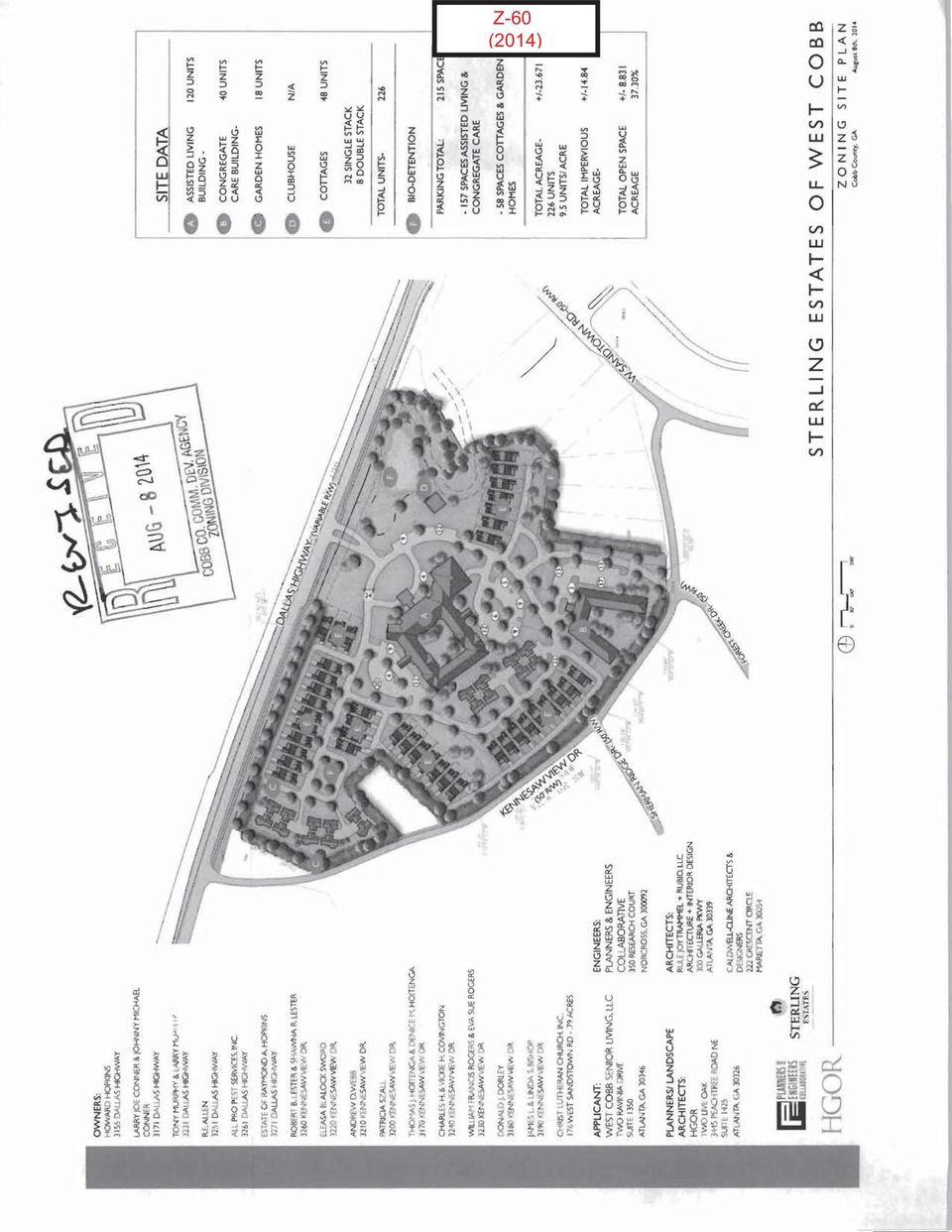
1 Z-60 (2014)

2 Z-60 (2014)
3 THIS PAGE INTENTIONALLY LEFT BLANK

4 APPLICANT: West Cobb Senior Living, LLC PETITION NO: Z-60 PHONE#: (770) HEARING DATE (PC): REPRESENTATIVE: Parks F. Huff, Esq. HEARING DATE (BOC): PHONE#: (770) PRESENT ZONING: R-20 TITLEHOLDER: Due to individual parcels, a complete list of titleholders is available in the Zoning Office PROPOSED ZONING: RSL PROPERTY LOCATION: Southwest side of Dallas Highway, northeast side of Kennesaw View Drive, west of West Sandtown Road PROPOSED USE: Senior Living Community ( Due to numerous addresses, a complete list of addresses can be found in the file in the Zoning Office). ACCESS TO PROPERTY: Dallas Highway and Kennesaw View Drive SIZE OF TRACT: acres DISTRICT: 20 PHYSICAL CHARACTERISTICS TO SITE: Single-family houses LAND LOT(S): 331, 332 PARCEL(S): Multiple parcels on file in the Zoning Div TAXES: PAID X DUE CONTIGUOUS ZONING/DEVELOPMENT COMMISSION DISTRICT: 1 NORTH: SOUTH: EAST: WEST: R-20/Single-family houses, wooded acreage and a lake R-20/Sherman Ridge, Nature's Walk and Forest Creek Trail Subdivisions R-20/Kennesaw View Subdivision; Single-family house and church R-20/Single-family house and LRO/Offices OPPOSITION: NO. OPPOSED PETITION NO: SPOKESMAN PLANNING COMMISSION RECOMMENDATION APPROVED MOTION BY REJECTED SECONDED HELD CARRIED BOARD OF COMMISSIONERS DECISION APPROVED MOTION BY REJECTED SECONDED HELD CARRIED STIPULATIONS:

5 LRO Z-60 NRC R-20 Dallas Hwy Dallas Hwy Site R-20 Sherman Ridge Dr Kennesaw View Dr R-20/OSC Forest Creek Dr R-20/OSC This map is provided for display and planning purposes only. It is not meant to be a legal description Feet [ City Boundary Zoning Boundary

6 APPLICANT: West Cobb Senior Living, LLC PETITION NO.: Z-60 PRESENT ZONING: R-20 PETITION FOR: RSL * * * * * * * * * * * * * * * * * * * * * * * * * * * * * * * * * * * * * * * * * * * * * * * * * * * * * * * * ZONING COMMENTS: Staff Member Responsible: Jason A. Campbell Land Use Plan Recommendation: Low Density Residential (1-2.5 units per acre) Proposed Number of Units: 226 Overall Density: 9.5 Units/Acre Staff estimate for allowable # of units: 41 Units* Increase of: 185 Units/Lots *Estimate could be higher or lower based on engineered plans taking into account topography, shape of property, utilities, roadways, natural features such as creeks, wetlands, etc., and other unforeseen circumstances. Applicant is requesting the Residential Senior Living (RSL) zoning category for the purpose of developing a senior living community comprised of an assisted living building (120 units); congregate care building (40 units); two quads (eight units); a clubhouse; and single-family lots (48 units). Building A on the site plan will be two stories and a basement, similar to the main building at the Sterling Estates development in East Cobb. Building B will be individual apartments/congregate care and will be two stories and will be the last stage of the development. The buildings will have traditional architecture and the unit square footages will range with the different products. Applicant has also indicated that there will be a wide range of sales prices and rental rates. The site plan submitted indicates acres (37.30 % of the total acres) will be set aside as open space. Applicant will require the following contemporaneous variances: 1. Allowance of 120 supportive units instead of the 100 allowed by code; 2. Waive the required 20-foot perimeter buffer to what is shown the on site plan; and 3. Allow two stories with basement. Cemetery Preservation: There is no significant impact on the cemetery site listed in the Cobb County Cemetery Preservation Commission s Inventory Listing which is located in this, or adjacent land lot.

7 APPLICANT: West Cobb Senior Living, LLC PETITION NO.: Z-60 PRESENT ZONING: R-20 PETITION FOR: RSL * * * * * * * * * * * * * * * * * * * * * * * * * * * * * * * * * * * * * * * * * * * * * * * * * * * * * * * SCHOOL COMMENTS: Number of Capacity Portable Name of School Enrollment Status Classrooms Elementary Middle High School attendance zones are subject to revision at any time. Additional Comments: * * * * * * * * * * * * * * * * * * * * * * * * * * * * * * * * * * * * * * * * * * * * * * * * * * * * * * FIRE COMMENTS: ACCESS: Fire apparatus access roads shall extend to within 150 feet of all portions of the facility or any portion of the exterior wall of the first floor (State Modifications IFC Edition). All access roads shall meet the American Association of State and Highway Transportation Officials (AASHTO) design manual live load standard HS20 (75,000 lbs.) with an unobstructed width of not less than 20 feet, 25 foot inside radius, 50 foot outside turning radius and unobstructed vertical clearance of not less than 13 feet 6 inches. Maximum slope of the access road in reference to the apparatus is 10% Front to Back and 5% Side to Side. Maximum grade of roadways leading to Fire Access roads refer to the Cobb County Development Standard Section 400: 14% for Non-Residential. Maximum angle of departure is 8.5%. Dead-end access roads in excess of 150 feet shall be provided with a turn-around (IFC Edition). Cul-de-sac with or without an island: minimum 60-foot radius to outside curb, measured to inside of curb and a minimum lane width = 24 feet (Cobb County Development Standard ). Single-Family cul-de-sac without island: 38-foot outside radius with island reverts to commercial dimensions. Hammerhead turn-around: total of 110 feet needed (45 feet + 20 feet wide roadway + 45 feet). Aerial apparatus access shall be required for all structures over 30 feet in height measured from the lowest level of fire department access to the ceiling height of the highest occupied floor level. Aerial fire apparatus access roads shall be a minimum width of 24 feet maximum of 40 feet from the structure and be positioned parallel to one entire side of the building. No overhead utility and power lines shall be located within the aerial fire apparatus access. (Cobb County Development Standards )

8 APPLICANT: West Cobb Senior Living, LLC PETITION NO.: Z-60 PRESENT ZONING: R-20 PETITION FOR: RSL * * * * * * * * * * * * * * * * * * * * * * * * * * * * * * * * * * * * * * * * * * * * * * * * * * * * * * * * PLANNING COMMENTS: The applicant is requesting a rezoning from R-20 to RSL for purpose of senior living community. The acre site is located on southwest side of Dallas Highway, northeast side of Kennesaw View Drive, west of West Sandtown Road. Comprehensive Plan The parcel is within a Low Density Residential (LDR) future land use category, with R-20 zoning designation. The purpose of the Low Density Residential (LDR) category is to provide for areas that are suitable for low density housing between one (1) and two and one-half (2.5) dwelling units per acre. This category presents a range of densities. Specific Standards from Comprehensive Plan In an effort to halt the expansion of commercial nodes, to assist with the revitalization of declining structures, and the need to provide an adequate transition and buffering to protect the surrounding VLDR and RR neighborhoods; the properties located along the south side of Dallas Highway west of West Sandtown Road and east of Kennesaw View Drive are to be Low Density Residential (LDR). The LDR area should be constrained by Kennesaw View Drive and West Sandtown Road so that it will not set a precedent for higher densities in this area of Cobb County. Preferred developments in this LDR area would be made up of an assemblage of properties with a single curb cut on Dallas Highway. Any development should maintain the focus of the development on Dallas Highway so that it can transition to a less intense development plan along Kennesaw View Drive in an effort to minimize impacts of the neighboring established residential areas. Densities should be a maximum of two (2) units per acre for single family detached dwelling units and a maximum of four (4) units per acre for developments using the Residential Senior Living zoning category. Master Plan/Corridor Study Not applicable. Historic Preservation After consulting various county historic resources surveys, historic maps, archaeology surveys and Civil War trench location maps, staff finds that no known significant historic resources appear to be affected by this application. No further comment. No action by applicant requested at this time. Design Guidelines Is the parcel in an area with Design Guidelines? Yes No If yes, design guidelines area _Dallas Highway Design Guidelines

9 APPLICANT: West Cobb Senior Living, LLC PETITION NO.: Z-60 PRESENT ZONING: R-20 PETITION FOR: RSL * * * * * * * * * * * * * * * * * * * * * * * * * * * * * * * * * * * * * * * * * * * * * * * * * * * * * * * * PLANNING COMMENTS: (Continued) Does the current site plan comply with the design requirements? Pedestrian access to buildings Yes No Not applicable Streetscape elements Yes No Not applicable Building Frontage Yes No Not applicable Parking Standard Yes No Not applicable Architecture standard Yes No Not applicable Incentive Zones Is the property within an Opportunity Zone? Yes No The Opportunity Zone is an incentive that provides $3,500 tax credit per job in eligible areas if two or more jobs are being created. This incentive is available for new or existing businesses. Is the property within an Enterprise Zone? Yes No The Enterprise Zone is an incentive that provides tax abatements and other economic incentives for qualifying businesses locating or expanding within designated areas for new jobs and capital investments. Is the property eligible for incentives through the Commercial and Industrial Property Rehabilitation Program? Yes No The Commercial and Industrial Property Rehabilitation Program is an incentive that provides a reduction in ad valorem property taxes for qualifying redevelopment in eligible areas. Special Districts Is this property within the Cumberland Special District #1 (hotel/motel fee)? Yes No Is this property within the Cumberland Special District #2 (ad valorem tax)? Yes No

10 APPLICANT West Cobb Senior Living PETITION NO. Z-060 PRESENT ZONING R-20 PETITION FOR RSL ********************************************************* WATER COMMENTS: NOTE: Comments reflect only what facilities were in existence at the time of this review. Available at Development: Yes No Fire Flow Test Required: Yes No Size / Location of Existing Water Main(s): 8" DI / N side of Dallas Hwy Additional Comments: Master meter to be at public ROW Developer may be required to install/upgrade water mains, based on fire flow test results or Fire Department Code. This will be resolved in the Plan Review Process. ******************************************************** SEWER COMMENTS: NOTE: Comments reflect only what facilities were in existence at the time of this review. In Drainage Basin: Yes No At Development: Yes No Approximate Distance to Nearest Sewer: In Dallas Hwy ROW Estimated Waste Generation (in G.P.D.): A D F= Peak= Treatment Plant: South Cobb Plant Capacity: Available Not Available Line Capacity: Available Not Available Projected Plant Availability: 0-5 years 5-10 years over 10 years Dry Sewers Required: Yes No Off-site Easements Required: Yes* No Flow Test Required: Yes No Letter of Allocation issued: Yes No Septic Tank Recommended by this Department: Yes No *If off-site easements are required, Developer must submit easements to CCWS for review/approval as to form and stipulations prior to the execution of easements by the property owners. All easement acquisitions are the responsibility of the Developer Subject to Health Department Approval: Yes No Additional Comments: Developer will be responsible for connecting to the existing County water and sewer systems, installing and/or upgrading all outfalls and water mains, obtaining on and/or offsite easements, dedication of on and/or offsite water and sewer to Cobb County, as may be required. Rezoning does not guarantee water/sewer availability/capacity unless so stated in writing by the Cobb County Water System. Permit issuances subject to continued treatment plant compliance with EPD discharge requirements.
: 8\" DI / N side of Dallas Hwy Additional Comments: Master meter to be at public ROW")
11 APPLICANT: West Cobb Senior Living, LLC PETITION NO.: Z-60 PRESENT ZONING: R-20 PETITION FOR: RSL * * * * * * * * * * * * * * * * * * * * * * * * * * * * * * * * * * * * * * * * * * * * * * * * * * * * * * * * * * * STORMWATER MANAGEMENT COMMENTS FLOOD HAZARD: YES NO POSSIBLY, NOT VERIFIED DRAINAGE BASIN: Mud Creek FLOOD HAZARD INFO: Zone X FEMA Designated 100 year Floodplain Flood. Flood Damage Prevention Ordinance DESIGNATED FLOOD HAZARD. Project subject to the Cobb County Flood Damage Prevention Ordinance Requirements. Dam Breach zone from (upstream) (onsite) lake - need to keep residential buildings out of hazard. WETLANDS: YES NO POSSIBLY, NOT VERIFIED Location: within and adjacent to stream buffer The Owner/Developer is responsible for obtaining any required wetland permits from the U.S. Army Corps of Engineer. STREAMBANK BUFFER ZONE: YES NO POSSIBLY, NOT VERIFIED Metropolitan River Protection Area (within 2000' of Chattahoochee River) ARC (review 35' undisturbed buffer each side of waterway). Chattahoochee River Corridor Tributary Area - County review ( undisturbed buffer each side). Georgia Erosion-Sediment Control Law and County Ordinance - County Review/State Review. Georgia DNR Variance may be required to work in 25 foot streambank buffers. County Buffer Ordinance: 50, 75, 100 or 200 each side of creek channel. DOWNSTREAM CONDITION Potential or Known drainage problems exist for developments downstream from this site. Stormwater discharges must be controlled not to exceed the capacity available in the downstream storm drainage system. Minimize runoff into public roads. Minimize the effect of concentrated stormwater discharges onto adjacent properties. Developer must secure any R.O.W required to receive concentrated discharges where none exist naturally Existing Lake Downstream. Additional BMP's for erosion sediment controls will be required. Lake Study needed to document sediment levels. Stormwater discharges through an established residential neighborhood downstream. Project engineer must evaluate the impact of increased volume of runoff generated by the proposed project on downstream receiving system.
 (onsite) lake - need to keep residential buildings out of hazard.")
12 APPLICANT: West Cobb Senior Living, LLC PETITION NO.: Z-60 PRESENT ZONING: R-20 PETITION FOR: RSL * * * * * * * * * * * * * * * * * * * * * * * * * * * * * * * * * * * * * * * * * * * * * * * * * * * * * * * * STORMWATER MANAGEMENT COMMENTS Continued SPECIAL SITE CONDITIONS Provide comprehensive hydrology/stormwater controls to include development of out parcels. Submit all proposed site improvements to Plan Review. Any spring activity uncovered must be addressed by a qualified geotechnical engineer (PE). Structural fill must be placed under the direction of a qualified registered Georgia geotechnical engineer (PE). Existing facility. Project must comply with the Water Quality requirements of the CWA-NPDES-NPS Permit and County Water Quality Ordinance. Water Quality/Quantity contributions of the existing lake/pond on site must be continued as baseline conditions into proposed project. Calculate and provide % impervious of project site. Revisit design; reduce pavement area to reduce runoff and pollution. INSUFFICIENT INFORMATION No Stormwater controls shown Copy of survey is not current Additional comments may be forthcoming when current site conditions are exposed. No site improvements showing on exhibit. ADDITIONAL COMMENTS 1. The proposed impervious coverage is the same as the current underlying residential zoning.
.")
13 APPLICANT: West Cobb Senior Living, LLC PETITION NO.: Z-60 PRESENT ZONING: R-20 PETITION FOR: RSL * * * * * * * * * * * * * * * * * * * * * * * * * * * * * * * * * * * * * * * * * * * * * * * * * * * * * TRANSPORTATION COMMENTS The following comments and recommendations are based on field investigation and office review of the subject rezoning case: ROADWAY AVERAGE DAILY TRIPS ROADWAY CLASSIFICATION SPEED LIMIT JURISDICTIONAL CONTROL MIN. R.O.W. REQUIREMENTS Dallas Highway 43,300 Arterial 55 mph Georgia DOT 100 Kennesaw View Drive N/A Local 25 mph Cobb County 50 Based on 2002 traffic counting data taken by Cobb County DOT (Dallas Highway) COMMENTS AND OBSERVATIONS Dallas Highway is classified as an arterial and according to the available information the existing right-of-way does meet the minimum requirements for this classification. Kennesaw View Drive is classified as a local and according to the available information the existing right-of-way does meet the minimum requirements for this classification. RECOMMENDATIONS Recommend curb, gutter, and sidewalk along the Kennesaw View Drive frontage. Recommend Applicant coordinate with Cobb County DOT prior to development plan approval to ensure compatibility with the Dallas Highway Trail Project. Recommend deceleration lane for the Dallas Highway access. Recommend a Traffic Study. Georgia Department of Transportation permits required for all work that encroaches upon State right-of-way. Recommend applicant be required to meet all Cobb County Development Standards and Ordinances related to project improvements.

14 STAFF RECOMMENDATIONS Z-60 WEST COBB SENIOR LIVING, LLC A. It is Staff's opinion that the applicant's rezoning proposal may not permit a use that is suitable in view of the use and development of adjacent and nearby properties. Other properties in the area are zoned and developed for single-family residential subdivisions, churches, and offices. B. It is Staff's opinion that the applicant's rezoning proposal may not have an adverse affect on the usability of adjacent or nearby property, as long as the density is more consistent with the adjacent residential uses. The development proposes a mixture of senior residential uses including, assisted living, independent living and congregate care living. C. It is Staff's opinion that the applicant's rezoning proposal will not result in a use which would cause an excessive or burdensome use of existing streets, transportation facilities, utilities, or schools. This opinion can be supported by the departmental comments contained in this analysis. D. It is Staff's opinion that the applicant's rezoning proposal is not in conformity with the policy and intent of the Cobb County Comprehensive Plan, which delineates this property to be within the Low Density Residential (LDR) land use category. RSL Non-supportive is compatible with the LDR land use category, while RSL Supportive is designed to be located within properties delineated as Regional Activity Center (RAC), Community Activity Center (CAC) or Neighborhood Activity Center (NAC). The Cobb County Comprehensive Plan contains language specifically for the development of a Residential Senior Living zoning category for this property. That language limits the density for an RSL development to a maximum of four units per acre. The applicant is proposing 9.5 units per acre. E. It is Staff's opinion that there are existing and changing conditions affecting the use and development of the property which give supporting grounds for approving the applicant's rezoning proposal, but at a density consistent with the Cobb County Comprehensive Plan, which specifically limits the density for an RSL development on this property. Staff would recommend approval at a maximum of four units per acre. Staff believes this will allow for adequate transition and buffering to protect the surrounding VLDR and RR neighborhoods as mentioned in the Cobb County Comprehensive Plan. Based on the above analysis, Staff recommends APPROVAL subject to the following conditions: Site plan to be approved by the Board of Commissioners, with the District Commissioner approving minor modifications; Maximum of four units per acre; Fire Department comments and recommendations; Water and Sewer Division comments and recommendations; Stormwater Management Division comments and recommendations; and Department of Transportation comments and recommendations. The recommendations made by the Planning and Zoning Staff are only the opinions of the Planning and Zoning Staff and are by no means the final decision. The Cobb County Board of Commissioners makes the final decisions on all Rezoning and Land Use Permits at an advertised public hearing.

15

PLANNED UNIT DEVELOPMENT & SIDEWALK WAIVER REQUEST STAFF REPORT Date: November 7, 2013
 PLANNED UNIT DEVELOPMENT & SIDEWALK WAIVER REQUEST STAFF REPORT Date: November 7, 2013 NAME LOCATION Audubon Properties, LLC. 4700 & 4960 Dauphin Island Parkway West side of Dauphin Island Parkway, 580
City of Valdosta Land Development Regulations. Table of Contents
 TITLE 1 ADMINISTRATION Chapter 102 General Provisions 102-1 Title 102-2 Purpose 102-3 Authority 102-4 Jurisdiction 102-5 Application of Ordinance 102-6 Relationship to Existing Ordinances 102-7 Powers
WESTFIELD-WASHINGTON ADVISORY PLAN COMMISSION December 7, 2015 1512-SPP-24 & 1512-ODP-24
 Petition Number: Subject Site Address: Petitioner: Request: East side of Oak Road, north of 151 st Street Langston Development Co. Primary Plat and Overall Development Plan amendment review for Mapleridge
Land Disturbance, Erosion Control and Stormwater Management Checklist. Walworth County Land Conservation Department
 Land Disturbance, Erosion Control and Stormwater Management Checklist Walworth County Land Conservation Department The following checklist is designed to assist the applicant in complying with the Walworth
Adopted 9/23/98 CHATTAHOOCHEE CORRIDOR PLAN. The goals of the Chattahoochee Corridor Plan (hereinafter also referred to as the Plan ) are:
 are:") CHATTAHOOCHEE CORRIDOR PLAN Adopted 9/23/98 PART 1: GOALS. POLICY. COVERAGE. A. Goals The goals of the Chattahoochee Corridor Plan (hereinafter also referred to as the Plan ) are: 1. Preservation and protection
CHATTAHOOCHEE CORRIDOR PLAN Adopted 9/23/98 PART 1: GOALS. POLICY. COVERAGE. A. Goals The goals of the Chattahoochee Corridor Plan (hereinafter also referred to as the Plan ) are: 1. Preservation and protection
How To Amend A Stormwater Ordinance
 Regulatory Alternatives to Address Stormwater Management and Flooding in the Marlboro Street Study Area Alternative 1: Amend Existing Local Regulations This proposed alternative provides an incremental
ENGINEERING DESIGN GUIDELINES. for SUBDIVISIONS OR COMMERCIAL DEVELOPMENTS
 ENGINEERING DESIGN GUIDELINES for SUBDIVISIONS OR COMMERCIAL DEVELOPMENTS City of Birmingham Department of Planning, Engineering and Permits Engineering Division Office of the City Engineer 2008 TABLE
City of Sugar Hill Planning Staff Report AX 15-004
 City of Sugar Hill Planning Staff Report AX 15-4 DATE: TO: FROM: SUBJECT: September 3, 215 Mayor & Council Planning Director \cj.r Annexation Request AX 15-4 I 568, 5722 & 5872 Suwanee Dam Road Tax Parcel
Zoning Districts, Gwinnett County, Georgia
 Zoning Districts, Gwinnett County, Georgia The zoning district descriptions in this section should be used as a guide only for the unincorporated areas of Gwinnett County. Before buying or selling property,
SITE DEVELOPMENT PLAN CHECKLIST. Project Name: Site Plan No.:
 SITE DEVELOPMENT PLAN CHECKLIST 5/12/05 Rev.3/14/06 Project Name: Site Plan No.: REVIEW CRITERIA Plans: A site development plan (signed and sealed) shall be on a 24 x 36 sheet at a scale that is no smaller
AREA: 2.37 acres NUMBER OF LOTS: 1 FT. NEW STREET: 0 LF. Single-family, Non-conforming machine shop
 FILE NO.: Z-8958 NAME: Rock Structure Repair Short-form PID LOCATION: Located at 8024 Stanton Road DEVELOPER: Rock Structure Repair Attn. Rudy Gutierrez 3 Kipling Court Little Rock, AR 72209 ENGINEER:
Kirkland Zoning Code 113.25
 Kirkland Zoning Code 113.25 Chapter 113 COTTAGE, CARRIAGE AND TWO/THREE-UNIT HOMES Sections: 113.05 User Guide 113.10 Voluntary Provisions and Intent 113.15 Housing Types Defined 113.20 Applicable Use
ORDINANCE NO. 2013 -
 ORDINANCE NO. 2013 - AN ORDINANCE OF BREVARD COUNTY, FLORIDA AMENDING CHAPTER 62, LAND DEVELOPMENT REGULATIONS SECTION 62-2891, LOT DRAINAGE, AND CHAPTER 22 BUILDINGS AND BUILDING REGULATIONS, SECTION
Preliminary Plan Application and Checklist
 ALL APPLICATIONS ARE DUE AT 12:00 NOON ON THE FILING DATE Office Use Only PRELIMINARY / REVISED PRELIMINARY PLAN $300.00 Fee Paid: $ Date Paid: ALL FIELDS HIGHLIGHTED IN RED ARE REQUIRED FIELDS Case No.:
Frequently-Asked Questions about Floodplains and Flood Insurance FLOOD INSURANCE
 Frequently-Asked Questions about Floodplains and Flood Insurance What is a floodplain? The floodplain is any area covered by water during normal water flows, and which could be inundated as a result of
FILE NO.: Z-6915-C. Gamble Road Short-form PCD and Land Alteration Variance Request
 FILE NO.: Z-6915-C NAME: Gamble Road Short-form PCD and Land Alteration Variance Request LOCATION: Located on the Northwest corner of Chenal Parkway and Gamble Road DEVELOPER: Davis Properties P.O. Box
CLACKAMAS COUNTY ZONING AND DEVELOPMENT ORDINANCE
 1008 STORM DRAINAGE (3/24/05) 1008.01 PURPOSE To minimize the amount of stormwater runoff resulting from development utilizing nonstructural controls where possible, maintain and improve water quality,
Planning and Zoning Commission Johnston, Iowa June 29, 2015
 ITEM NO. 15-19 Planning and Zoning Commission Johnston, Iowa June 29, 2015 SUBJECT: Consider recommending approval of the Final Plat for Crosshaven Plat 6 subdividing 28.28 acres into 47 single family
Chapter 7 ZONING PLAN
 Chapter 7 ZONING PLAN Introduction This Chapter opens with a general description of a zoning plan. It is followed by a brief explanation of the relationship between this Growth Management Plan and the
1161.01 CONFORMITY WITH PLANS; DRAINAGE.
 CHAPTER 1161 Subdivision Requirements 1161.01 Conformity with plans; drainage 1161.07 Easements 1161.02 Trees 1161.08 Streets 1161.03 Subdivision name 1161.09 Blocks 1161.04 Street names 1161.10 Lots 1161.05
Chapter 3 SENSITIVE AREAS AND VEGETATED CORRIDORS
 Chapter 3 3.01 General Provisions 3.01.1 Introduction 3.01.2 Application and Interpretation of Chapter 3.01.3 Unbuildable Lots 3.01.4 Other Permits 3.01.5 Prohibited Activities 3.02 Service Provider Letter
LAND USE CODE CHAPTER 18.68 GENERAL REGULATIONS
 CHAPTER 18.68 GENERAL REGULATIONS SECTIONS: 18.68.010 Fences. 18.68.020 Vision Clearance Area. 18.68.030 Access. 18.68.040 Yard Requirements. 18.68.050 Special Setback Requirements. 18.68.070 Land Surveys.
Rezoning case no. RZ15-08: Adam Development Properties, LP
 PLANNING AND ZONING COMMISSION STAFF REPORT June 4, 2015 Rezoning case no. RZ15-08: Adam Development Properties, LP CASE DESCRIPTION: LOCATION: a request to amend the development plan of a previously-approved
Chapter 5.0. Stormwater Credits for Innovative Site Planning
 Chapter 5.0 Stormwater Credits for Innovative Site Planning Chapter 5. Stormwater Credits...Introduction 5.0 Stormwater Credits In Maryland, there are many programs at both the State and local level that
Division 51-4.400. Yard, Lot, and Space Regulations.
 Division 51-4.400. Yard, Lot, and Space Regulations. SEC. 51-4.401. MINIMUM FRONT YARD. (a) General provisions. (1) Required front yards must be open and unobstructed except for fences. Except as otherwise
D3 April 8, 2015 Public Hearing
 D3 April 8, 2015 Public Hearing APPLICANT AND PROPERTY OWNER: ASSEMBLY OF YAH, INC. STAFF PLANNER: Kevin Kemp REQUEST: Conditional Use Permit (Religious Facility - church) ADDRESS / DESCRIPTION: 5151 Locke
ENVIRONMENTAL REVIEW SCREENING QUESTIONS
 ENVIRONMENTAL REVIEW SCREENING QUESTIONS All applications to WHEDA are required to meet the Department of Housing and Urban Development s environmental compliance standards listed in 24 CFR Part 58. Your
AREA: 0.16 acres NUMBER OF LOTS: 1 FT. NEW STREET: 0 LF
 FILE NO.: Z-9020 NAME: Hometown Tax Service Short-form PD-O LOCATION: Located at 3008 West 12 th Street DEVELOPER: Mark Green 65 Westfield Loop Little Rock, AR 72210 SURVEYOR: Kittler-Roberts Group, LLP
PROFFER STATEMENT REZONING TLZM 2013-0001 LEEGATE November 1, 2013
 PROFFER STATEMENT REZONING TLZM 2013-0001 LEEGATE November 1, 2013 Leegate LLC and Stanley Martin Companies, LLC, owner and applicant, (the Applicant ) of certain property described as Loudoun County Tax
FILE NO.: Z-8403. LOCATION: Located on the Northeast and Southeast corners of West 12 th Street and Dennison Street
 FILE NO.: Z-8403 NAME: Glason Short-form POD LOCATION: Located on the Northeast and Southeast corners of West 12 th Street and Dennison Street DEVELOPER: Dennis Glason c/o the Law Office of Simmons S.
REPORT OF THE PLANNING AND DEVELOPMENT DEPARTMENT FOR APPLICATION FOR REZONING ORDINANCE 2015-0183 TO PLANNED UNIT DEVELOPMENT APRIL 9, 2015
 AWH REPORT OF THE PLANNING AND DEVELOPMENT DEPARTMENT FOR APPLICATION FOR REZONING ORDINANCE 2015-0183 TO PLANNED UNIT DEVELOPMENT APRIL 9, 2015 The Planning and Development Department hereby forwards
The 2002 Development Regulations. The City of Sugar Hill, Georgia
 The 2002 Development Regulations The City of Sugar Hill, Georgia Table of Contents TABLE OF CONTENTS Article Page 1 AUTHORITY, TITLE, PURPOSE AND INTENT ------------------- 1.1 1.1 Authority and Title
INTRODUCTION TO ZONING DISTRICT REGULATIONS
 INTRODUCTION TO ZONING DISTRICT REGULATIONS Classification of Zoning Districts Zoning districts in Dorchester County are categorized as Suburban Urban, Suburban Transition, or Rural. These districts are
Corridor Goals and Objectives
 Corridor Goals and Objectives This chapter presents the goals and objectives, developed by the Corridor Study Committee, that serve as the purpose and intent of the Corridor Plan. This plan covers a twenty
Flood Protection in Garland Past, Present, and Future. Presented by: R. Lyle Jenkins, P.E., CFM City of Garland, Texas
 Flood Protection in Garland Past, Present, and Future Presented by: R. Lyle Jenkins, P.E., CFM City of Garland, Texas A few facts about Garland: Originally incorporated in 1891 Population 226,876 (2010
County of San Diego, Planning & Development Services SECOND DWELLING UNIT
 County of San Diego, Planning & Development Services ZONING DIVISION The Zoning Ordinance, Section 6156.x, allows the addition of a second dwelling unit to those properties zoned to allow the Family Residential
d. Building permits may only be approved if consistent with the approved development plan and land division for all units with common walls.
 Section 20.920.060 Tier 2 Infill Standards. In addition to the Tier 1 standards and incentives, Tier 2 infill parcels and land divisions and the subsequent development on those Tier 2 infill parcels shall
PLANNING COMMISSION REPORT Regular Agenda - Public Hearing Item
 Z-15-00063 Item No. 1-1 PLANNING COMMISSION REPORT Regular Agenda - Public Hearing Item PC Staff Report 04/20/2015 ITEM NO. 1 Z-15-00063 CS TO RS5; 832 Ohio Street (BJP) Z-15-00063: Consider a request
REZONING 16-000009 & PRELIMINARY PLAT 16-000005
 REZONING 16-000009 & PRELIMINARY PLAT 16-000005 REZONING REQUEST AND REVISED PRELIMINARY PLAT FOR THE BLUFFS AT WINDCASTLE - 4165 FAREDALE LANE Application: Engineer: Developer: Property Owner: Current
URBAN DRAINAGE CRITERIA
 URBAN DRAINAGE CRITERIA I. Introduction This division contains guidelines for drainage system design and establishes a policy for recognized and established engineering design of storm drain facilities
Site Development Information Worksheet for single family residential development
 Site Development Information Worksheet for single family residential development Project description: Address: Owner Name: Phone No. Date Signature & phone number of Individual who Completed this Worksheet
FILING REQUIREMENTS EXCERPTS FROM THE ZONING ORDINANCE SOLAR ENERGY SYSTEMS
 County of San Diego, Planning & Development Services APPLICANT S GUIDE FOR A SOLAR ENERGY SYSTEM ZONING DIVISION These guidelines provide information on how to apply for a Solar Energy System. Review the
Residential Plan Review Emergency Vehicle Access and Water Supply Permit Information Packet
 Residential Plan Review Emergency Vehicle Access and Water Supply Permit Information Packet 1. Definitions a. AHJ Authority Having Jurisdiction. The Fire Chief or Fire Marshal of a given Fire District
THE APPRAISAL OF REAL ESTATE 3 RD CANADIAN EDITION BUSI 330
 THE APPRAISAL OF REAL ESTATE 3 RD CANADIAN EDITION BUSI 330 REVIEW NOTES by CHUCK DUNN CHAPTER 10 Copyright 2010 by the Real Estate Division and Chuck Dunn. All rights reserved ARE 3 rd EDITION REVIEW
PLANNING DIVISION STAFF REPORT February 23, 2015. Summary. Background Information PREPARED FOR THE PLAN COMMISSION. Legistar File ID # 36810
 PLANNING DIVISION STAFF REPORT PREPARED FOR THE PLAN COMMISSION Project Address: Application Type: Legistar File ID # 36810 Prepared By: Summary Conditional Use Timothy M. Parks, Planning Division Report
ARTICLE 22. AKB ARTHUR K. BOLTON PARKWAY OVERLAY ZONE
 ARTICLE 22. AKB ARTHUR K. BOLTON PARKWAY OVERLAY ZONE Sec. 2201. Purpose. AKB is an overlay zone which governs the development of property located along the Arthur K. Bolton Parkway (Georgia Highway 16
Harris County Flood Control District. Policy, Criteria, and Procedure Manual
 Harris County Flood Control District Policy, Criteria, and Procedure Manual For Approval and Acceptance of Infrastructure General Review October 10, 2003 Draft Please Provide Written Comments to the HCFCD
PRELIMINARY PROJECT REVIEW PROCESS
 CITY OF CYPRESS 5275 Orange Avenue Cypress, California 90630 (714) 229-6720 PRELIMINARY PROJECT REVIEW PROCESS 1. Discuss project with Planning staff to determine zoning regulations, unusual characteristics
EXISTING STRUCTURES 1) FAIR MARKET VALUE OF STRUCTURE(s) BEFORE IMPROVEMENT: 2) COST OF IMPROVEMENTS:
 FAIR MARKET VALUE OF STRUCTURE(s) BEFORE IMPROVEMENT: 2) COST OF IMPROVEMENTS:") Date Received: Received By: Project/Permit Number: Fee: (To be Completed by MOA) FLOOD HAZARD PERMIT APPLICATION (Please fill out application completely; Indicate NA if necessary. Property information
Date Received: Received By: Project/Permit Number: Fee: (To be Completed by MOA) FLOOD HAZARD PERMIT APPLICATION (Please fill out application completely; Indicate NA if necessary. Property information
SITE PLAN REVIEW APPLICATION
 SITE PLAN REVIEW APPLICATION 405 Martin Luther King Jr. Blvd phone (919) 968-2728 fax (919) 969-2014 www.townofchapelhill.org Parcel Identifier Number (PIN): Date: Section A: Project Information Section
Low Impact Development Checklist
 New Jersey Stormwater Best Management Practices Manual February 2004 A P P E N D I X A Low Impact Development Checklist A checklist for identifying nonstructural stormwater management strategies incorporated
Application No.: 14.074 Steve Rush, representing Rocky Mountain Power Rocky Mountain Power Project Location: approximately 1600 N. 6800 E.
 Planning Commission Staff Report Planning and Development Services Croydon Substation Conditional Use Permit Public Meeting August 28, 2014 Application No.: 14.074 Applicant: Steve Rush, representing Rocky
8.1.3 General Design Guidelines. The following guidelines shall be used when designing inlets along a street section:
 . Introduction Presented in this chapter are the criteria and methodology for design and evaluation of storm sewer inlets located in Town of Castle Rock. The review of all planning submittals will be based
COUNTY OF ALBEMARLE PLANNING STAFF REPORT SUMMARY. Staff: Claudette Grant
 COUNTY OF ALBEMARLE PLANNING STAFF REPORT SUMMARY Project Name: ZMA 2013-00004 Hollymead Town Center Block VI Planning Commission Public Hearing: July 29, 2014 Staff: Claudette Grant Board of Supervisors
CPED STAFF REPORT Prepared for the City Planning Commission
 CPED STAFF REPORT Prepared for the City Planning Commission CPC Agenda Item #1 June 23, 2014 RLS-72 LAND USE APPLICATION SUMMARY Property Location: 222 Hennepin Avenue Project Name: 222 Prepared By: Becca
Ferry County Out Building Application
 Ferry County Out Building Application 1. Will the building be larger than 1000 square feet? Yes No 2. Will the building have eave projections greater than 2 feet? Yes No 3. Will the building be greater
NOTICE OF A TYPE Ix DECISION ON A PROPOSAL IN YOUR NEIGHBORHOOD
 Date: June 29, 2016 To: From: Interested Person Susan Ellis, Land Use Services 503-823-5361 / [email protected] NOTICE OF A TYPE Ix DECISION ON A PROPOSAL IN YOUR NEIGHBORHOOD The Bureau of
Chapter 2 PLAN AND PLAT REVIEW PROCESS
 www.cityofknoxville.org/engineering/ Chapter 2 PLAN AND PLAT REVIEW PROCESS 2.1 Overall Sequence for Large Projects The overall sequence of major development and redevelopment projects will generally follow
The checklist utilized by the Authority will be similar to that which is shown below. Project Name: Location: Consulting Engineering Firm:
 Page 1 of 6 Section 1. PURPOSE This policy is an Engineering checklist of the Local Review Program for sanitary sewer improvement projects by the Bedford Regional Water Authority ( Authority ). Section
ALACHUA COUNTY COMPREHENSIVE PLAN 2011-2030
 ALACHUA COUNTY COMPREHENSIVE PLAN 2011-2030 Adopted April 5, 2011 (Ordinance 11-01, Effective July 22, 2011; Housing Element effective August 23, 2011) Updated through January 21, 2016 Alachua County Growth
Industrial Suburban District Regulations City of St. Petersburg City Code Chapter 16, Land Development Regulations
 16.20.110 - Industrial Suburban District ( IS ) Figure REFERENCE Typical Buildings in the IS District Figure REFERENCE Site Plan of a typical development in the IS District Sections: 16.20.110.1 Composition
City of Springboro 320 West Central Avenue, Springboro, Ohio. Planning Commission Regular Meeting. Wednesday, June 25, 2014
 City of Springboro 320 West Central Avenue, Springboro, Ohio Wednesday, I. Call to Order and Roll Call Chairperson Hans Landefeld called the Springboro Planning Commission Meeting to order at the Springboro
9. Does the County of San Diego keep home plans on file for existing homes?
 County of San Diego, Planning & Development Services FIRESTORM POLICY DOCUMENT BUILDING DIVISION FIRE REBUILD Answers to Commonly Asked Questions The County of San Diego understands the confusion and frustration
City of Colleyville Community Development Department. Site/Landscape Plan Application Packet
 City of Colleyville Community Development Department Site/Landscape Plan Application Packet Development Application Fees City of Colleyville 100 Main Street Colleyville TX 76034 817.503.1050 Zoning Zoning
CITY OF VAUGHAN SCHEDULE O LOT GRADING DESIGN FOR RESIDENTIAL DEVELOPMENT
 Page 1 CITY OF VAUGHAN SCHEDULE O LOT GRADING DESIGN FOR RESIDENTIAL DEVELOPMENT CIVIC CENTRE 2141 MAJOR MACKENZIE DRIVE MAPLE ONTARIO L6A 1T1 905-832-2281 Page 2 SECTION 1 - GENERAL OBJECTIVES To provide
CITY OF WEST PALM BEACH ZONING BOARD OF APPEALS Meeting Date: February 6, 2014 Zoning Board of Appeals Case No. 3302
 CITY OF WEST PALM BEACH ZONING BOARD OF APPEALS Meeting Date: February 6, 2014 Zoning Board of Appeals Case No. 3302 1950 Golden Lakes Blvd. Class B Special Use Permit Location Aerial I. REQUEST Site is
Summary and Description of 2014 Enhancements to New Jersey Model Stormwater Control Ordinance for Municipalities
 Summary and Description of 2014 Enhancements to New Jersey Model Stormwater Control Ordinance for Municipalities This document summarizes and provides explanation for the purpose and intent of major recommended
CITY OF WEST PALM BEACH PLANNING BOARD Meeting Date: August 20, 2013 Planning Board Case No. 1564C
 CITY OF WEST PALM BEACH PLANNING BOARD Meeting Date: August 20, 2013 Planning Board Case No. 1564C Rezoning from Community Service (CS) to Community Service Planned Development (CSPD) Hanley Center 5200
5.14 Floodplains and Drainage/Hydrology
 I-70 East Final EIS 5.14 Floodplains and Drainage/Hydrology 5.14 Floodplains and Drainage/Hydrology This section discusses floodplain and drainage/hydrology resources and explains why they are important
DECISION/DIRECTION NOTE
 DECISION/DIRECTION NOTE Title: Proposed rezoning new residential zone PDE file MPA1500006 150 Stavanger Drive Date Prepared: April 12, 2016 Report To: Chair and Members, Planning and Development Committee
Homeowner s Guide to Drainage
 Homeowner s Guide to Drainage a scottsdale homeowner s guide to drainage produced by the city of scottsdale s stormwater management division Transportation Department TABLE OF CONTENTS Introduction 2 Drainage
TOWN OF CARY CONDITIONAL USE ZONING PERMIT. 412 Rutherglen Cary, NC 27511-6437. 412 Rutherglen Cary, NC 27511-6437
 TOWN OF CARY CONDITIONAL USE ZONING PERMIT PETITION: PETITIONER(S): OWNER(S): LOCATION: 01-REZ-16 204 N. Dixon Avenue, Cary, NC PARCEL IDENTIFICATION: 076418218784 REALID: 0031004 AREA: APPROVED ZONING:
City of Douglas Commercial Building Permit Site Application
 City of Douglas Commercial Building Permit Site Application *Complete the following information including a complete site plan and floor plan. *Incomplete information may result in delay and/or rejection
SOLD. Lot 1. 1 Mile: Population: 10,200 Median HH Income: $33,100. 3 Mile: Population: 80,200 Median HH Income: $34,900
 Walmart Outparcels For Sale College Station, TX Store # 1150 1815 Brothers Blvd FM 2818 W SOLD Texas Ave S/ Hwy 6 Longmire Dr Brothers Blvd Lot 1 For more information about this site, contact: Lot 1: ±2.41
Lower Raritan Watershed Management Area Stormwater & Flooding Subcommittee Strategy Worksheet LRSW-S3C1
 Strategy Name: Reduce Existing Potential for Flood Damages LRSW-S3C1. Develop and implement a program to: Minimize flood damages through the use of structural measures. Minimize flood damages through the
PC 23-11 Nate Lundgren-Auto Repair Business Conditional Use Permit 9/7/11 Applicants
 PC 23-11 Nate Lundgren-Auto Repair Business Conditional Use Permit 9/7/11 Applicants Nate Lundgren Triple K Partnership Mankato 105 LeSueur Ave 320 Mallard Lane Eagle Lake, MN 56024 Mankato MN 560001 Request
SECTION 108 - INLETS 108.1 INLET LOCATIONS
 Greene County Design Standards -Adopted April 5, 1999 SECTION 108 - INLETS SECTION 108 - INLETS 108.1 INLET LOCATIONS 108.2 INLET INTERCEPTION CAPACITIES 108.2.1 Clogging Factors 108.3 INTERCEPTION AND
CITY OF HIGHLAND PARK, ILLINOIS Stormwater Management Fact Sheet
 CITY OF HIGHLAND PARK, ILLINOIS Stormwater Management Fact Sheet WHAT IS STORMWATER MANAGEMENT? Stormwater management is the method for channeling rainfall through pipes and sewers away from property to
Floodplain Development Land Use Review
 COMMUNITY DEVELOPMENT DEPARTMENT Planning Division P.O. Box 490 333 Broadalbin Street SW Albany, OR 97321 Phone 541-917-7550 Fax 541-791-0150 www.cityofalbany.net Floodplain Development Land Use Review
HIGHWAY DEPARTMENT ACCESS AND RIGHT OF WAY WIDTH GUIDELINES
 Approved 6/26/01 HIGHWAY DEPARTMENT ACCESS AND RIGHT OF WAY WIDTH GUIDELINES All new, modified and/or changed use access(es) onto county roads shall be subject to the access and corridor protection guidelines
7.0 INTRODUCTION 7.1 BACKGROUND
 Section 7: Economic Development 7.0 INTRODUCTION A community s character is a function of its residential neighborhoods, its open spaces, and its commercial districts. Commercial uses also play another
STAFF REPORT. Rezoning #PLN2014-00099, Knightsbridge (Woodbridge Magisterial District)
") COUNTY OF PRINCE WILLIAM 5 County Complex Court, Prince William, Virginia 22192-9201 PLANNING (703) 792-7615 FAX (703) 792-4401 OFFICE Internet www.pwcgov.org Christopher M. Price, AICP Director of Planning
COUNTY OF PRINCE WILLIAM 5 County Complex Court, Prince William, Virginia 22192-9201 PLANNING (703) 792-7615 FAX (703) 792-4401 OFFICE Internet www.pwcgov.org Christopher M. Price, AICP Director of Planning
Neighborhood Business. Neighborhood Mixed Use. Community Business. Factoria Land Use District 1 2A 2A 2A 30 (23) 15 (23) 30 (23) 30 (23)
 15 (23) 30 (23) 30 (23)") 20.20.010 s in land use distris dimensional requirements. Chart 20.20.010 s in land use distris Dimensional Requirements STD LAD USE CODE REF LAD USE CLASSIFICATIO Professional / 2 Light Industry General
20.20.010 s in land use distris dimensional requirements. Chart 20.20.010 s in land use distris Dimensional Requirements STD LAD USE CODE REF LAD USE CLASSIFICATIO Professional / 2 Light Industry General
Neighborhood Planning Guide To Zoning
 City of Austin Neighborhood Planning Guide To Zoning City of Austin Planning & Development Review Department 505 Barton Springs Road One Texas Center Austin, TX 78704 June 2014 DISCLAIMER: This Guide is
OKANOGAN COUNTY OFFICE OF PLANNING AND DEVELOPMENT FLOODPLAIN DEVELOPMENT PERMIT APPLICATION
 OKANOGAN COUNTY OFFICE OF PLANNING AND DEVELOPMENT FLOODPLAIN DEVELOPMENT PERMIT APPLICATION Okanogan County Code, OCC 15.08, Floodplain Management The State of Washington has authorized county governments
SECTION 7 UNDERDRAIN SERVICE
 SECTION 7 UNDERDRAIN SERVICE ARTICLE I USE OF THE PUBLIC UNDERDRAIN SYSTEM 7.100 The purpose of the District s underdrain system is to provide a method for conveying ground water from around building foundations
Answers to Commonly Asked Questions
 County of San Diego, Planning & Development Services FIRESTORM POLICY AND GUIDANCE DOCUMENT BUILDING DIVISION Answers to Commonly Asked Questions The County of San Diego understands the confusion and frustration
1.7.0 Floodplain Modification Criteria
 1.7.0 Floodplain Modification Criteria 1.7.1 Introduction These guidelines set out standards for evaluating and processing proposed modifications of the 100- year floodplain with the following objectives:
The Metropolitan Planning Commission. DATE: May 19, 2015
 TO: FROM: The Metropolitan Planning Commission MPC Staff DATE: May 19, 2015 SUBJECT: Petition of LLC, Owner Harold Yellin, Agent PIN: 2-0015-01-002 & 003 Lot Size:.85 Acres (approximately) Aldermanic District:
5901 Milwaukee Street Planned Unit Development (GDP) (Second Addition to Grandview Commons)
 (Second Addition to Grandview Commons)") DATE: March 8, 2006 TO: FROM: SUBJECT: Plan Commission Larry D. Nelson, P.E., City Engineer 5901 Milwaukee Street Planned Unit Development (GDP) (Second Addition to Grandview Commons) The City Engineering
DATE: March 8, 2006 TO: FROM: SUBJECT: Plan Commission Larry D. Nelson, P.E., City Engineer 5901 Milwaukee Street Planned Unit Development (GDP) (Second Addition to Grandview Commons) The City Engineering
SITE-SPECIFIC BEST MANAGEMENT PRACTICES (SSBMP) PLAN/STORM WATER POLLUTION PREVENTION PLAN (SWPPP) REVIEW CHECKLIST
 PLAN/STORM WATER POLLUTION PREVENTION PLAN (SWPPP) REVIEW CHECKLIST") This checklist may be used by applicants for encroachment permits, and contractors in development of Site Specific Best Management Practice (SSBMP) Plans or Storm Water Pollution Prevention Plans (SWPPP)
This checklist may be used by applicants for encroachment permits, and contractors in development of Site Specific Best Management Practice (SSBMP) Plans or Storm Water Pollution Prevention Plans (SWPPP)
REVISED GENERAL DEVELOPMENT PLAN PDR-99-02(G)(R-2) - GAMBLE CREEK, L.C./TWIN RIVER
(R-2) - GAMBLE CREEK, L.C./TWIN RIVER") REVISED GENERAL DEVELOPMENT PLAN PDR-99-02(G)(R-2) - GAMBLE CREEK, L.C./TWIN RIVER THE BOARD OF COUNTY COMMISSIONERS OF MANATEE COUNTY, FLORIDA, having specifically considered the recommendation of the
REVISED GENERAL DEVELOPMENT PLAN PDR-99-02(G)(R-2) - GAMBLE CREEK, L.C./TWIN RIVER THE BOARD OF COUNTY COMMISSIONERS OF MANATEE COUNTY, FLORIDA, having specifically considered the recommendation of the
SECTION 1.0 STATUTORY AUTHORIZATION AND PURPOSE
 A local law for Flood Damage Prevention as authorized by the New York State Constitution, Article IX, Section 2, and Environmental Conservation Law, Article 36 1.1 FINDINGS SECTION 1.0 STATUTORY AUTHORIZATION