REZONING & PRELIMINARY PLAT
|
|
|
- Alvin Patterson
- 7 years ago
- Views:
Transcription
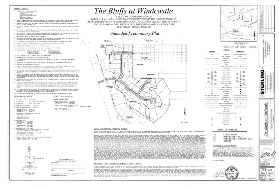
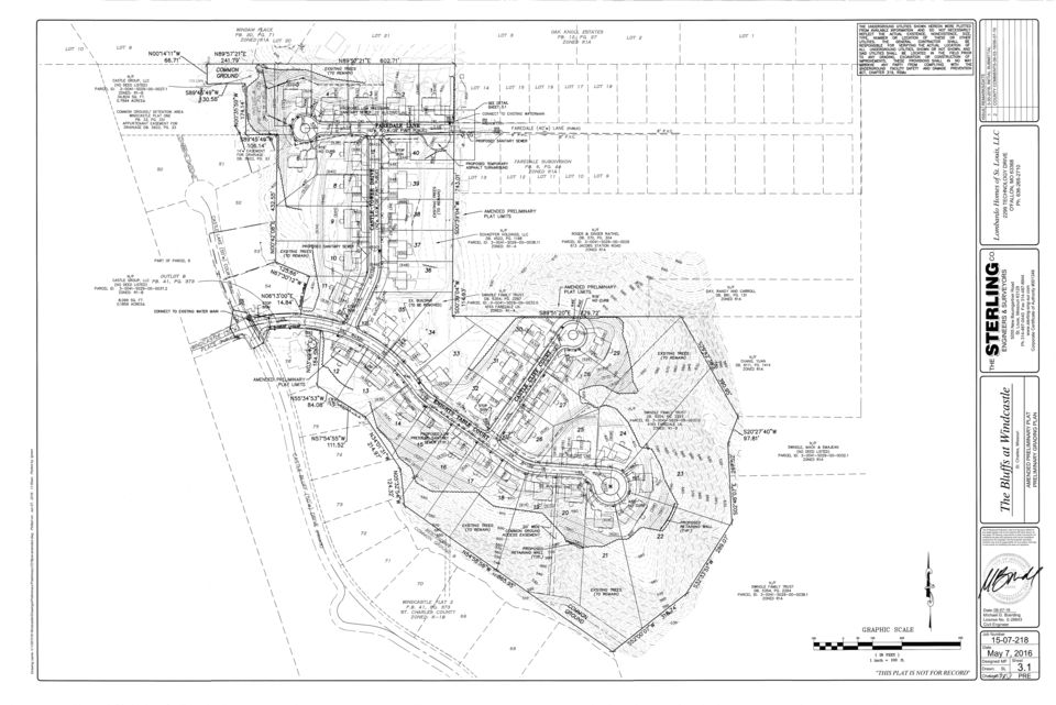
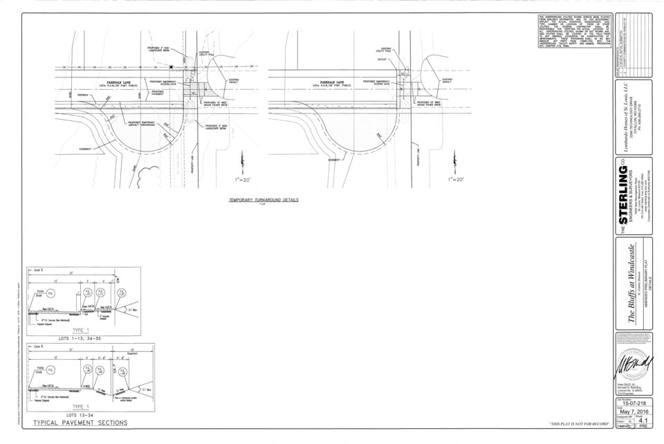
1 REZONING & PRELIMINARY PLAT REZONING REQUEST AND REVISED PRELIMINARY PLAT FOR THE BLUFFS AT WINDCASTLE FAREDALE LANE Application: Engineer: Developer: Property Owner: Current Zoning: Requested Zoning: Number of Lots: 2 Area: Location: Council District: 7 Account No.: RZ and PRE The Sterling Company Lombardo Homes of St. Louis, LLC Swindle Family Trust R1A, Single-Family Residential District (1 acre minimum lot size) R1B, Single-Family Residential District (20,000 square foot minimum lot size) 1.76 acres Approximately 620 feet south of the terminus of Faredale Lane, and 500 feet east of the intersection of Castle Bluff Drive and Windcastle Place A000 CONTENTS: Staff Recommendation Photo(s) of Site Aerial Photo Surrounding Zoning Map Future Land Use Map Preliminary Plat Letters received None

2 STAFF RECOMMENDATION To: County Planning and Zoning Commission Prepared by: Jan Whipple Application No.: RZ Date: June 15, 2015 GENERAL INFORMATION Applicant: Owners: Requested Action: Location: Size: Current Land Use: Adjacent Land Use and Zoning: Year 2025 Plan: Zoning History: Lombardo Homes of St. Louis, LLC Swindle Family Trust To rezone a property from R1A, Single Family Residential (1 acre minimum lot size) to R1B, Single Family Residential (20,000 sq. ft. minimum lot size) Faredale Lane, Approximately 620 feet south of the terminus of Faredale Lane and 500 feet east of the intersection of Castle Bluff Drive and Windcastle Place acres Single family residence Direction Zoning Land Use North South East West R1A, Single Family Residential R1B, Single Family Residential R1A, Single Family Residential and R1B, Single Family Residential R1B, Single Family Residential Low Density Residential (1-4 dwelling units per acre) Vacant, future subdivision The Bluffs at Windcastle Vacant, future subdivision The Bluffs at Windcastle Single Family Residential and future subdivision The Bluffs at Windcastle Vacant, future subdivision The Bluffs at Windcastle This property was zoned Agricultural with the inception of zoning in In 1973 the property was rezoned to R-1A, Single Family Residential with the adoption of the Revised Zoning Order. SPECIAL INFORMATION Public Services: Utilities: County Council District 7 John White School District R3, Francis Howell School District Fire District Cottleville Fire District Water Missouri American Water Company Sewer Duckett Creek Sanitary District
.")
3 ANALYSIS Staff finds the proposal to rezone the subject property from the current R1A, Single Family Residential District (1 acre minimum lot size) to R1B, Single Family Residential District (20,000 sq. ft. minimum lot size) appropriate at this location. The property is the location of the original single family residence that was on an approximately 90 acre tract of land. Acreage has been sold off from this site for the development of Windcastle Plat 2 and The Bluffs at Windcastle. This 1.76 acre tract will be developed with 2 lots as part of The Bluffs at Windcastle. The proposed zoning change is keeping with the R1B zoning of The Bluffs at Windcastle that surrounds the site and Windcastle Plat 2 located further west of the subject site. Additionally, Faredale Subdivision located northeast of the site is developed with 20,000 square foot lots of record in the R1A district and further east of the site across Jacobs Station Road The Trails of Jacobs Summit was developed as a PUD in the R1B district. The 2025 Master Plan recommends residential development in this area as Low Density Residential at a density of 1 to 4 units per acre. The R1B zoning designation has a density of just over 2 units per acre, which is in keeping with the 1 to 4 units per acre. RECOMMENDATION The Planning and Zoning Division Staff recommends approval of the zoning change. The density and lot areas proposed are in keeping with area developments.

4 RZ
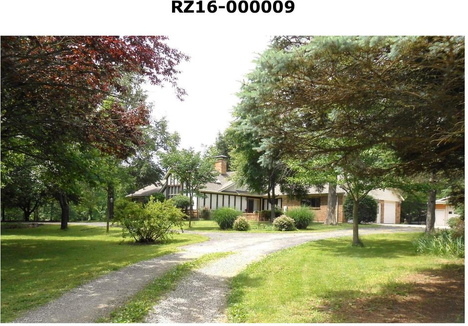
5 Application RZ Aerial Subject Property

6 Application RZ Zoning Subject Property

7 Subject Property Application RZ Future Land Use Plan

8
9

10
11
Case 1775. Request: Rezone from (A) Agricultural District and (RA) Single Family Residential District to (RB) Two Unit Residential District
 Agricultural District and (RA) Single Family Residential District to (RB) Two Unit Residential District") Case 1775 Applicant: York Breckenridge GP, LLC 1301 South Capital of Texas Highway Suite B-201 Austin Texas.778746 512-369-3030 Request: Rezone from (A) Agricultural District and (RA) Single Family Residential
Case 1775 Applicant: York Breckenridge GP, LLC 1301 South Capital of Texas Highway Suite B-201 Austin Texas.778746 512-369-3030 Request: Rezone from (A) Agricultural District and (RA) Single Family Residential
Planning and Zoning Commission Johnston, Iowa June 29, 2015
 ITEM NO. 15-19 Planning and Zoning Commission Johnston, Iowa June 29, 2015 SUBJECT: Consider recommending approval of the Final Plat for Crosshaven Plat 6 subdividing 28.28 acres into 47 single family
Rezoning case no. RZ15-08: Adam Development Properties, LP
 PLANNING AND ZONING COMMISSION STAFF REPORT June 4, 2015 Rezoning case no. RZ15-08: Adam Development Properties, LP CASE DESCRIPTION: LOCATION: a request to amend the development plan of a previously-approved
WESTFIELD-WASHINGTON ADVISORY PLAN COMMISSION December 7, 2015 1512-SPP-24 & 1512-ODP-24
 Petition Number: Subject Site Address: Petitioner: Request: East side of Oak Road, north of 151 st Street Langston Development Co. Primary Plat and Overall Development Plan amendment review for Mapleridge
City of Springboro 320 West Central Avenue, Springboro, Ohio. Planning Commission Regular Meeting. Wednesday, June 25, 2014
 City of Springboro 320 West Central Avenue, Springboro, Ohio Wednesday, I. Call to Order and Roll Call Chairperson Hans Landefeld called the Springboro Planning Commission Meeting to order at the Springboro
City of El Paso City Plan Commission Staff Report
 City of El Paso City Plan Commission Staff Report Revised Case No: SUSU14-00124 Fresno Place Replat A Application Type: Resubdivision Combination CPC Hearing Date: February 12, 2015 Staff Planner: Joaquin
STAFF REPORT PLANNING COMMISSION REGULAR MEETING OF OCTOBER 20, 2015. Debbie Hill, Associate Planner dhill@brentwoodca.gov 9386-A1
 STAFF REPORT PLANNING COMMISSION REGULAR MEETING OF OCTOBER 20, 2015 PREPARED BY: AGENDA ITEM & FILE NUMBER: PROJECT DESCRIPTION: PROJECT SIZE & LOCATION: GENERAL PLAN: ZONING: OWNER/APPLICANT: Debbie
PLANNING COMMISSION REPORT Regular Agenda - Public Hearing Item
 Z-15-00063 Item No. 1-1 PLANNING COMMISSION REPORT Regular Agenda - Public Hearing Item PC Staff Report 04/20/2015 ITEM NO. 1 Z-15-00063 CS TO RS5; 832 Ohio Street (BJP) Z-15-00063: Consider a request
INTRODUCTION TO ZONING DISTRICT REGULATIONS
 INTRODUCTION TO ZONING DISTRICT REGULATIONS Classification of Zoning Districts Zoning districts in Dorchester County are categorized as Suburban Urban, Suburban Transition, or Rural. These districts are
CITY OF WEST PALM BEACH PLANNING BOARD Meeting Date: August 20, 2013 Planning Board Case No. 1564C
 CITY OF WEST PALM BEACH PLANNING BOARD Meeting Date: August 20, 2013 Planning Board Case No. 1564C Rezoning from Community Service (CS) to Community Service Planned Development (CSPD) Hanley Center 5200
COUNTY OF ALBEMARLE PLANNING STAFF REPORT SUMMARY. Staff: Claudette Grant
 COUNTY OF ALBEMARLE PLANNING STAFF REPORT SUMMARY Project Name: ZMA 2013-00004 Hollymead Town Center Block VI Planning Commission Public Hearing: July 29, 2014 Staff: Claudette Grant Board of Supervisors
A Break Even Analysis and Potential Profitability of a Proposed Residential Development within the City of La Crosse, Wisconsin USA
 A Break Even Analysis and Potential Profitability of a Proposed Residential Development within the City of La Crosse, Wisconsin USA Chad M. Clower Department of Resource Analysis, Saint Mary s University
Urban Planning and Land Use
 Urban Planning and Land Use 701 North 7 th Street, Room 423 Phone: (913) 573-5750 Kansas City, Kansas 66101 Fax: (913) 573-5796 Email: planninginfo@wycokck.org www.wycokck.org/planning To: From: Unified
CITY OF WINTER GARDEN
 CITY OF WINTER GARDEN CITY COMMISSION REGULAR MEETING MINUTES A REGULAR MEETING of the Winter Garden City Commission was called to order by Mayor Rees at 6:30 p.m. at City Hall, 300 West Plant Street,
City of Sugar Hill Planning Staff Report AX 15-004
 City of Sugar Hill Planning Staff Report AX 15-4 DATE: TO: FROM: SUBJECT: September 3, 215 Mayor & Council Planning Director \cj.r Annexation Request AX 15-4 I 568, 5722 & 5872 Suwanee Dam Road Tax Parcel
THIS PAGE INTENTIONALLY LEFT BLANK
 Z-60 (2014) Z-60 (2014) THIS PAGE INTENTIONALLY LEFT BLANK APPLICANT: West Cobb Senior Living, LLC PETITION NO: Z-60 PHONE#: (770) 422-7016 EMAIL: phuff@slhb-law.com HEARING DATE (PC): 09-4-14 REPRESENTATIVE:
SACRAMENTO COUNTY SUMMARY OF ZONING CLASSIFICATIONS
 SACRAMENTO COUNTY SUMMARY OF ZONING CLASSIFICATIONS This document provides a brief overview of zoning designations only. Inaccuracies may be present. Please consult the Sacramento County Zoning Code for
LAND USE ELEMENT APPENDIX
 II LAND USE ELEMENT APPENDIX Arnold Community Plan CHART C CONSISTENT ZONES, POPULATION DENSITY, BUILDING INTENSITY Land use designation Consistent Dwellings Persons Zone per acre per acre Single family
Staff Report General Development Plan/Master Plan Aldermanic District: 1 County Commission District: 2 MPC File No. 16-000526-PLAN February 23, 2016
 Staff Report General Development Plan/Master Plan Aldermanic District: 1 County Commission District: 2 MPC File No. 16-000526-PLAN February 23, 2016 1101 Bull Street One West Park Avenue 1107 Bull Street
MACOMB TOWNSHIP PLANNING COMMISSION MEETING MINUTES AND PUBLIC HEARING TUESDAY, May 5, 2009 PAGE 1 OF 8
 PAGE 1 OF 8 LOCATION: PRESENT: ABSENT: ALSO PRESENT: MACOMB TOWNSHIP MEETING CHAMBERS 54111 BROUGHTON ROAD MACOMB, MI 48042 EDWARD GALLAGHER, CHAIRMAN DEAN AUSILIO, VICE CHAIRMAN MICHAEL D. KOEHS, SECRETARY
Revised General Plan Amendment Report (GPAR) PAA 05-017 GPA 06-003 BC 05-0104 R06-006 ER06-08-024 APN # 268-130-43 APN # 268-130-42
 PAA 05-017 GPA 06-003 BC 05-0104 R06-006 ER06-08-024 APN # 268-130-43 APN # 268-130-42") LAW OFFICES OF VATCHE CHORBAJIAN ATTORNEYS AT LAW 655 North Central Avenue 17 th Floor Glendale, CA 91203 phone 818.409.6700 fax 858.923.2124 12707 High Bluff Dr, Ste 100 San Diego, CA 92130 phone 858.259.5577
LAW OFFICES OF VATCHE CHORBAJIAN ATTORNEYS AT LAW 655 North Central Avenue 17 th Floor Glendale, CA 91203 phone 818.409.6700 fax 858.923.2124 12707 High Bluff Dr, Ste 100 San Diego, CA 92130 phone 858.259.5577
DEPARTMENT OF DEVELOPMENT SERVICES PLANNING FEES AND COSTS Revised 10/26/2012
 ZONING DEPARTMENT OF DEVELOPMENT SERVICES PLANNING FEES AND COSTS Revised 10/26/2012 [ ] PD Sketch Plan with phasing plan $2,000 plus $20/acre over 5 acres Retainer - $1,500 [ ] PD Preliminary Site Plan
Chapter 7 ZONING PLAN
 Chapter 7 ZONING PLAN Introduction This Chapter opens with a general description of a zoning plan. It is followed by a brief explanation of the relationship between this Growth Management Plan and the
AREA: 0.16 acres NUMBER OF LOTS: 1 FT. NEW STREET: 0 LF
 FILE NO.: Z-9020 NAME: Hometown Tax Service Short-form PD-O LOCATION: Located at 3008 West 12 th Street DEVELOPER: Mark Green 65 Westfield Loop Little Rock, AR 72210 SURVEYOR: Kittler-Roberts Group, LLP
Zoning Districts, Gwinnett County, Georgia
 Zoning Districts, Gwinnett County, Georgia The zoning district descriptions in this section should be used as a guide only for the unincorporated areas of Gwinnett County. Before buying or selling property,
FILE NO.: Z-8403. LOCATION: Located on the Northeast and Southeast corners of West 12 th Street and Dennison Street
 FILE NO.: Z-8403 NAME: Glason Short-form POD LOCATION: Located on the Northeast and Southeast corners of West 12 th Street and Dennison Street DEVELOPER: Dennis Glason c/o the Law Office of Simmons S.
STATEMENT OF PURPOSE
 STATEMENT OF PURPOSE Community Properties, Inc. ( CPI ) is applying to Chatham County for approval of a major subdivision, Meadowview PUD (the Project ), with access to NC 87 and Old Graham Road, just
City Code of ANN ARBOR, MICHIGAN Chapter 55 Zoning
 ARTICLE II. USE REGULATIONS 5:10.2. R1A, R1B, R1C, R1D single family dwelling district (1) Intent. (a) These single family residential districts are designed to provide an environment of predominantly
D3 April 8, 2015 Public Hearing
 D3 April 8, 2015 Public Hearing APPLICANT AND PROPERTY OWNER: ASSEMBLY OF YAH, INC. STAFF PLANNER: Kevin Kemp REQUEST: Conditional Use Permit (Religious Facility - church) ADDRESS / DESCRIPTION: 5151 Locke
PROPERTY LINE ADJUSTMENT APPLICATION
 PROPERTY LINE ADJUSTMENT APPLICATION City of Klamath Falls Planning Division 226 S. 5 th St. / P.O. Box 237, Klamath Falls, OR 97601 File No. A property line adjustment is required any time an adjustment
COUNTYWIDE APRIL 2016 DEVELOPMENT SERVICES OPEN FOR BUSINESS INDICATORS
 COUNTYWIDE APRIL 2016 DEVELOPMENT SERVICES OPEN FOR BUSINESS INDICATORS BUILDING DIVISION Permits Issued 1,907 Inspections Performed 4,137 Certificates of Occupancy Issued 27 DEVELOPMENT REVIEW ENGINEERING
STAFF REPORT. CITY OF COLUMBUS PLAN COMMISSION (October 14, 2015 Meeting)
") City of Columbus Bartholomew County Planning Department 123 Washington Street Columbus, Indiana 47201 Phone: (812) 376-2550 Fax: (812) 376-2643 STAFF REPORT CITY OF COLUMBUS PLAN COMMISSION (October 14,
City of Columbus Bartholomew County Planning Department 123 Washington Street Columbus, Indiana 47201 Phone: (812) 376-2550 Fax: (812) 376-2643 STAFF REPORT CITY OF COLUMBUS PLAN COMMISSION (October 14,
AREA: 2.37 acres NUMBER OF LOTS: 1 FT. NEW STREET: 0 LF. Single-family, Non-conforming machine shop
 FILE NO.: Z-8958 NAME: Rock Structure Repair Short-form PID LOCATION: Located at 8024 Stanton Road DEVELOPER: Rock Structure Repair Attn. Rudy Gutierrez 3 Kipling Court Little Rock, AR 72209 ENGINEER:
PLANNED UNIT DEVELOPMENT & SIDEWALK WAIVER REQUEST STAFF REPORT Date: November 7, 2013
 PLANNED UNIT DEVELOPMENT & SIDEWALK WAIVER REQUEST STAFF REPORT Date: November 7, 2013 NAME LOCATION Audubon Properties, LLC. 4700 & 4960 Dauphin Island Parkway West side of Dauphin Island Parkway, 580
PA-14-04/ORDINANCE 14-34 (DTS# 20140263) 24/7 DEVELOPMENT HOLDINGS, LLC BAYSHORE BLACKROCK
 24/7 DEVELOPMENT HOLDINGS, LLC BAYSHORE BLACKROCK") PC: 9-11-2014 PA-14-04/ORDINANCE 14-34 (DTS# 20140263) 24/7 DEVELOPMENT HOLDINGS, LLC BAYSHORE BLACKROCK Adoption of a Plan Amendment of the Board of County Commissioners of Manatee County, Florida, regarding
PC: 9-11-2014 PA-14-04/ORDINANCE 14-34 (DTS# 20140263) 24/7 DEVELOPMENT HOLDINGS, LLC BAYSHORE BLACKROCK Adoption of a Plan Amendment of the Board of County Commissioners of Manatee County, Florida, regarding
RESIDENTIAL BUILDING PERMIT REQUIREMENTS
 RESIDENTIAL BUILDING PERMIT REQUIREMENTS The Building Inspection Division has compiled this packet to help our customers obtain a Building Permit. Enclosed we have listed all departments and inspection
CITY OF WEST PALM BEACH ZONING BOARD OF APPEALS Meeting Date: February 6, 2014 Zoning Board of Appeals Case No. 3302
 CITY OF WEST PALM BEACH ZONING BOARD OF APPEALS Meeting Date: February 6, 2014 Zoning Board of Appeals Case No. 3302 1950 Golden Lakes Blvd. Class B Special Use Permit Location Aerial I. REQUEST Site is
ADMINISTRATIVE LAND SPLIT APPLICATION
 ADMINISTRATIVE LAND SPLIT APPLICATION File # Date Filed: PID: Landowner Name: Address: Description of Request: Phone: Administrative Land Splits 10.6.A Mortgages Subdivision for the purpose of securing
Case No.: A-9955-C COUNTY COUNCIL OF PRINCE GEORGE'S COUNTY, MARYLAND, SITTING AS THE DISTRICT COUNCIL ZONING ORDINANCE NO. 5-2005
 Case No.: A-9955-C Applicant: Florida on the Potomac, LLC COUNTY COUNCIL OF PRINCE GEORGE'S COUNTY, MARYLAND, SITTING AS THE DISTRICT COUNCIL ZONING ORDINANCE NO. 5-2005 AN ORDINANCE to amend the Zoning
Presentation to Knox County Commission Monday, February 23, 2015
 The Northwest County Sector Plan Update Presentation to Knox County Commission Monday, February 23, 2015 COMMUNITIES OF THE NORTHWEST COUNTY SECTOR Ball Camp Cedar Bluff Last NW Sector Update: 2003 Land
Land Use and Zoning. Land Use Within the Port Madison Indian Reservation
 Land Use and Zoning Land Use Within the Port Madison Indian Reservation A portion of the Suquamish Rural Village is Trust land, owned either by the Tribe or individual tribal members. The following list
PROFFER STATEMENT REZONING TLZM 2013-0001 LEEGATE November 1, 2013
 PROFFER STATEMENT REZONING TLZM 2013-0001 LEEGATE November 1, 2013 Leegate LLC and Stanley Martin Companies, LLC, owner and applicant, (the Applicant ) of certain property described as Loudoun County Tax
TOWN OF DAVIE TOWN COUNCIL AGENDA REPORT
 TOWN OF DAVIE TOWN COUNCIL AGENDA REPORT TO: Mayor and Councilmembers FROM/PHONE: Mark Kutney, AICP, Development Services Director/(954) 797-1101 Prepared by Annie Feng, Planner II SUBJECT: Resolution
LEAVENWORTH COUNTY PLANNING COMMISSION MINUTES OF THE MEETING OF JUNE 12, 1991
 LEAVENWORTH COUNTY PLANNING COMMISSION MINUTES OF THE MEETING OF JUNE 12, 1991 Meeting called to order at 8=00 p.m. Members Present: Margaret Coffman, Ron Ernzen, Charles Lohman, Wesley Reed, Mildred Wilkerson
CPED STAFF REPORT Prepared for the City Planning Commission
 CPED STAFF REPORT Prepared for the City Planning Commission CPC Agenda Item #1 June 23, 2014 RLS-72 LAND USE APPLICATION SUMMARY Property Location: 222 Hennepin Avenue Project Name: 222 Prepared By: Becca
19310 STONE OAK PKWY, STE. 201 SAN ANTONIO, TEXAS 78258 T: 210.402.6363 F: 210.402.6767 www.drakecommercial.com
 Multi-Family Land Sonoma Verde Kyle Seale Parkway San Antonio, Texas DRAKE COMMERCIAL GROUP DEBORAH BAUER TRAVIS BAUER 19310 STONE OAK PKWY, STE. 201 SAN ANTONIO, TEXAS 78258 T: 210.402.6363 F: 210.402.6767
COMP PLAN SUBMITTAL CHECKLIST
 VILLAGE OF ROYAL PALM BEACH PLANNING and ZONING 1050 Royal Palm Beach Boulevard Royal Palm Beach, FL 33411 (561) 790-5131 DEVELOPMENT APPLICATION COMP PLAN SUBMITTAL CHECKLIST Application Date Received:
Neighborhood Planning Guide To Zoning
 City of Austin Neighborhood Planning Guide To Zoning City of Austin Planning & Development Review Department 505 Barton Springs Road One Texas Center Austin, TX 78704 June 2014 DISCLAIMER: This Guide is
d. Building permits may only be approved if consistent with the approved development plan and land division for all units with common walls.
 Section 20.920.060 Tier 2 Infill Standards. In addition to the Tier 1 standards and incentives, Tier 2 infill parcels and land divisions and the subsequent development on those Tier 2 infill parcels shall
Churches and Schools Development Standards
 Uses Code Provisions Site Development Standards RS-4 Sec.24-44 RD Sec. 24-45 RM-23 Sec. 24-48 Residential Single Family Residential Two- Family (Duplex) Residential Mid- Rise Multifamily (High Density)
TOWN OF CARY CONDITIONAL USE ZONING PERMIT. 412 Rutherglen Cary, NC 27511-6437. 412 Rutherglen Cary, NC 27511-6437
 TOWN OF CARY CONDITIONAL USE ZONING PERMIT PETITION: PETITIONER(S): OWNER(S): LOCATION: 01-REZ-16 204 N. Dixon Avenue, Cary, NC PARCEL IDENTIFICATION: 076418218784 REALID: 0031004 AREA: APPROVED ZONING:
Application No.: 14.074 Steve Rush, representing Rocky Mountain Power Rocky Mountain Power Project Location: approximately 1600 N. 6800 E.
 Planning Commission Staff Report Planning and Development Services Croydon Substation Conditional Use Permit Public Meeting August 28, 2014 Application No.: 14.074 Applicant: Steve Rush, representing Rocky
TOWN OF DAVIE TOWN COUNCIL AGENDA REPORT
 TOWN OF DAVIE TOWN COUNCIL AGENDA REPORT TO: FROM/PHONE: SUBJECT: Mayor and Councilmembers Mark Kutney, AICP (954) 797-1101 Quasi Judicial Hearing: Variance TITLE OF AGENDA ITEM: V 3-2-01 MDM Services/BP/Amoco,
ORDINANCE NO. 21-2014 (As Amended)
") ORDINANCE NO. 21-2014 (As Amended) To Amend the Official Zoning Map of the City of Worthington, Ohio, to Change Zoning of Certain Land from C-3, Institutions and Offices to PUD, Planned Unit Development
ORDINANCE NO. 21-2014 (As Amended) To Amend the Official Zoning Map of the City of Worthington, Ohio, to Change Zoning of Certain Land from C-3, Institutions and Offices to PUD, Planned Unit Development
FORMULA FOR FINDING THE SQUARE FEET OF A RECTANGLE L x W = A
 UNIT I REAL ESTATE MATH AREA MEASUREMENTS FORMULA FOR FINDING THE SQUARE FEET OF A RECTANGLE L x W = A Where: A = Area L = Length W = Width If the length = 30 and the width = 20 20 x 30 = 600 Sq. Feet
10.41 Acres Atmos Energy 917 Centre Park Blvd
 10.41 Acres Atmos Energy 917 Centre Park Blvd Points of Contact: Mr. Steve Jarvie Vice President The Staubach Company 15601 Dallas Parkway, Suite 400 Addison, Texas 75001 (972) 361-5202 (214) 725-6385
CHAPTER SIXTEEN PLANNING STANDARDS AND RATIOS
 CHAPTER SIXTEEN PLANNING STANDARDS AND RATIOS INTRODUCTION To the maximum extent possible, the Update proposes to incorporate the planning standards and ratios used in the Nevada County General Plan. This
University of Missouri-St. Louis North Station
 University of Missouri-St. Louis North Station This station profile describes existing conditions around the UMSL North MetroLink Station. This is one of a set of profiles for each of the MetroLink System
R-40 Single-Family Residential
 October 7, 2013 R-40 Single-Family Residential Description: This low-density district allows single-family structures on lots of at least 40,000 square feet (0.92 acres). Properties zoned R-40 are typically
FILE NO.: Z-6915-C. Gamble Road Short-form PCD and Land Alteration Variance Request
 FILE NO.: Z-6915-C NAME: Gamble Road Short-form PCD and Land Alteration Variance Request LOCATION: Located on the Northwest corner of Chenal Parkway and Gamble Road DEVELOPER: Davis Properties P.O. Box
NOTICE OF A TYPE Ix DECISION ON A PROPOSAL IN YOUR NEIGHBORHOOD
 Date: June 29, 2016 To: From: Interested Person Susan Ellis, Land Use Services 503-823-5361 / susan.ellis@portlandoregon.gov NOTICE OF A TYPE Ix DECISION ON A PROPOSAL IN YOUR NEIGHBORHOOD The Bureau of
TRAFFIC IMPACT ANALYSIS
 TRAFFIC IMPACT ANALYSIS Presenter Gerry Harter, PE, Area Traffic Engineer Acting Transportation and Land Use Director Why a TIA? Roads are a critical public resource and a major investment of public funds
Public Worksessions - A Summary of the New York City Zoning and Planning Study
 APPENDIX F Third Public Work Session Notice Presentation July 27, 2004 For Immediate Release July 12, 2004 Town of Rotterdam Notice of Public Meeting The Town of Rotterdam Public Works Department will
BOARD OF ZONING ADJUSTMENT STAFF REPORT Date: July 7, 2014
 BOARD OF ZONING ADJUSTMENT STAFF REPORT Date: July 7, 2014 CASE NUMBER 5898 APPLICANT NAME LOCATION Advantage Sign Company 3449 Hillcrest Road (Northeast corner of Hillcrest Road and Girby Road) VARIANCE
Affordable Dwelling Unit Ordinance
 Affordable Dwelling Unit Ordinance The following model ordinance establishes a voluntary program for encouraging supported affordable housing units through the review process of new developments. It is
REPORT OF THE PLANNING AND DEVELOPMENT DEPARTMENT FOR APPLICATION FOR REZONING ORDINANCE 2015-0183 TO PLANNED UNIT DEVELOPMENT APRIL 9, 2015
 AWH REPORT OF THE PLANNING AND DEVELOPMENT DEPARTMENT FOR APPLICATION FOR REZONING ORDINANCE 2015-0183 TO PLANNED UNIT DEVELOPMENT APRIL 9, 2015 The Planning and Development Department hereby forwards
From: CF/HC Community Facilities/Historic & Cultural Overlay. Requested change is compatible.
 Case Number _ZC-14-028_ ZONING MAP CHANGE STAFF REPORT City Council Meeting Date: Council District 9 April 1, 2014 Zoning Commission Recommendation: Approval as Amended by a vote of 9-0 to exclude the
The Metropolitan Planning Commission. DATE: May 19, 2015
 TO: FROM: The Metropolitan Planning Commission MPC Staff DATE: May 19, 2015 SUBJECT: Petition of LLC, Owner Harold Yellin, Agent PIN: 2-0015-01-002 & 003 Lot Size:.85 Acres (approximately) Aldermanic District:
High Point - Raymond Neighborhood Development Plan
 High Point - Raymond Neighborhood Development Plan Recommendations for Land Use and Development City Of Madison Department of Planning and Development Planning Unit December 1997 Amendments Adopted: December
MINUTES HUGO PLANNING COMMISSION December 19, 2013
 MINUTES HUGO PLANNING COMMISSION December 19, 2013 Call to Order Chairman Gwynn called the meeting to order at 7:00 pm. PRESENT: ABSENT: ALSO PRESENT: Arcand, Gwynn, Lessard, Kleissler, Knauss, McRoberts,
Chapter Four Land Use and Economic Development
 Chapter Four Land Use and Economic Development Land Use and Economic Development 33 Chapter 4 Land Use and Economic Development Introduction This chapter focuses on existing and future land uses in the
O R D I N A N C E NO. 699. AN ORDINANCE, establishing a subdistrict in St. Louis. County, Missouri, to be known as Subdistrict No.
 AMENDED BY ORDINANCE NO. 755 O R D I N A N C E NO. 699 AN ORDINANCE, establishing a subdistrict in St. Louis County, Missouri, to be known as Subdistrict No. 181 (Bataan and Boswell) of The Metropolitan
CITY OF WEST PALM BEACH PLANNING BOARD Meeting Date: September 24, 2012 Planning Board Case No. 1248Q
 CITY OF WEST PALM BEACH PLANNING BOARD Meeting Date: September 24, 2012 Planning Board Case No. 1248Q Morse Life Major Planned Development Amendment Location Aerial I. REQUEST Morse Campus outlined in
SIOR GREATER KANSAS CITY MUNICIPAL DEVELOPMENT REPORT CARD
 2 0 1 2 SIOR GREATER KANSAS CITY MUNICIPAL DEVELOPMENT REPORT CARD October 9, 2012 Greater Kansas City Municipal Development Report Card Table of Contents Introduction...3 Methods...4 Disclaimer...5 Office
County of San Diego, Planning & Development Services SECOND DWELLING UNIT
 County of San Diego, Planning & Development Services ZONING DIVISION The Zoning Ordinance, Section 6156.x, allows the addition of a second dwelling unit to those properties zoned to allow the Family Residential
Comparison of Infrastructure Costs for Alternatives
 R E F E technical R E document N C E Comparison of Infrastructure Costs for Alternatives June 1, 1987 Revised January 18, 1988 Prepared by: Wallace, Roberts & Todd 260 South Broad Street Philadelphia,
How To Improve Service In Arundel
 Draft of Economic Development Strategy - Town of Arundel Chapter 3.3 - Infrastructure, Transportation and Zoning 1. Infrastructure The lack of infrastructure in Arundel could present significant problems
RIVER NORTH - OFFICE BUILDING FORMER FIRE STATION 158 WEST ERIE STREET CHICAGO IL 60610
 RIVER NORTH - OFFICE BUILDING FORMER FIRE STATION FOR SALE The subject property is a 7,000 square foot office building on 2,544 square feet of land, currently occupied by a law firm. Built around the turn
VILLAGE OF PLEASANT PRAIRIE COMMERCIAL COMMUNICATION PERMIT
 VILLAGE OF PLEASANT PRAIRIE COMMERCIAL COMMUNICATION PERMIT CLASS 1 COLLOCATION New Commercial Communication Structure Substantial Modification Please check one of the following: CLASS 2 COLLOCATION OTHER
Rural Residential Buildable Lands Inventory
 The Dalles Periodic Review, May 2013 Rural Residential Lands Inventory Contents Introduction and Summary... 1 Concerns related to the 2007 Analysis... 2 Rural Residential Capacity Summary... 2 Methodology...
7 December 10, 2014 Public Hearing APPLICANT: OBEDIENT PAWS, L.L.C.
 7 December 10, 2014 Public Hearing APPLICANT: OBEDIENT PAWS, L.L.C. PROPERTY OWNER: DIANE BLACKISTON STAFF PLANNER: Graham Owen REQUEST: Conditional Use Permit (Home Occupation) ADDRESS / DESCRIPTION:
Development Project Report For the Month of: March 2014
 Project Project Description Project Status Commercial / Office Projects Collierville Auto Center DD# 12-046 Relocation of used automobile dealership comprised of two properties totaling 0.76 acre at 651
April 28, 2015. Stafford County Board of Zoning Appeals FROM: ATTACHMENTS: 3. Plat of property. 1. Application. 4. Layout of area used for business
 1 Board of Supervisors Gary F. Snellings, Chairman Laura A. Sellers, Vice Chairman Meg Bohmke Jack R. Cavalier Paul V. Milde, III Cord A. Sterling Robert Bob Thomas, Jr. April 28, 2015 Anthony J. Romanello,
Waterstone Business Park
 Orange County, North Carolina Waterstone Business Park Parcel Size Price Location Zoning Topography Combined total of 47 acres (Parcel #5-22 acres, #7-25 acres) $74,545 per acre (Parcel #5), $32,880 per
Chapter 13: Implementation Plan
 Chapter 13: 13.1. INTRODUCTION The purpose of the implementation chapter of the Comprehensive Plan is to set forth the actions that the City will take to ensure that the plans, programs and policies set
Appendix F THE LAKE BLUFF PARK DISTRICT POLICY FOR THE ACQUISITION, INVENTORY, SALE, LEASE, AND RETENTION OF PUBLIC PROPERTY
 Appendix F THE LAKE BLUFF PARK DISTRICT POLICY FOR THE ACQUISITION, INVENTORY, SALE, LEASE, AND RETENTION OF PUBLIC PROPERTY Section One: PURPOSE The Lake Bluff Park District is the owner of real property
Washington City Subdivision Development Application Checklist 435-656-6325
 Application Checklist 1 Washington City Subdivision Development Application Checklist 435-656-6325 1) Wednesday Staff and Developer Meeting. *Call to schedule an appointment. A. Statement of project intent
A bill to be entitled
 A bill to be entitled Page 1 of 7 An act relating to the City of Tampa, Hillsborough County; amending chapter 29126 (1953), Laws of Florida, relating to Parkland Estates Subdivision; amending the preamble
AVALON PARK WEST (FORMERLY NEW RIVER) PD/MPUD- NARRATIVE FOR DRI RESCISSION, PD SUBAREA AMENDMENT AND MPUD SUBSTANTIAL MODIFICATION.
 PD/MPUD- NARRATIVE FOR DRI RESCISSION, PD SUBAREA AMENDMENT AND MPUD SUBSTANTIAL MODIFICATION.") AVALON PARK WEST (FORMERLY NEW RIVER) PD/MPUD- NARRATIVE FOR DRI RESCISSION, PD SUBAREA AMENDMENT AND MPUD SUBSTANTIAL MODIFICATION DRI Rescission On January 7, 1992, the Pasco County Board of County Commissioners
AVALON PARK WEST (FORMERLY NEW RIVER) PD/MPUD- NARRATIVE FOR DRI RESCISSION, PD SUBAREA AMENDMENT AND MPUD SUBSTANTIAL MODIFICATION DRI Rescission On January 7, 1992, the Pasco County Board of County Commissioners
Major General Plan Amendment. Project Narrative
 Major General Plan Amendment BARNEY FARMS Project Narrative NEC of Signal Butte and Queen Creek Roads Prepared: Submitted to: TOWN OF QUEEN CREEK PLANNING DEPARTMENT 22350 South Ellsworth Road Queen Creek,
PC 23-11 Nate Lundgren-Auto Repair Business Conditional Use Permit 9/7/11 Applicants
 PC 23-11 Nate Lundgren-Auto Repair Business Conditional Use Permit 9/7/11 Applicants Nate Lundgren Triple K Partnership Mankato 105 LeSueur Ave 320 Mallard Lane Eagle Lake, MN 56024 Mankato MN 560001 Request
Location Property Location Display Location?: Street Address 1: State or Province: Country: Municipality/City: Yes PA USA Collegeville Postal Code: 19
 Perkiomen Bridge Hotel, Collegeville, PA Retail-Commercial For Sale Subtype(s): Restaurant, Tavern/Bar/Nightclub The Perkiomen Bridge Hotel is zoned V-2 (Village District). Permitted by right are single-family
For Sale. 11.1 Acres Raw Land. Jessica Daron Court Lilburn, Georgia
 For Sale 11.1 Acres Raw Land Jessica Daron Court Lilburn, Georgia Property Size: Location: Utilities: Zoning: 11.1 Acres 2030 Jessica Daron Court Lilburn, GA 30047 All utilities, including sewer C2 Gwinnett
RESIDENTIAL LOT FOR SALE
 RESIDENTIAL LOT FOR SALE North Lot 11 - Brentwood Subdivision Morristown (Hamblen County), Tennessee Offering Memorandum CONTACT US Jeff G. Jones at 615-445-9984 Bruce Nelson at 615-651-4677 or Toll Free
A PPENDICES C OLLIERVILLE 2040 LAND USE PLAN UPDATE
 A PPENDICES C OLLIERVILLE 2040 LAND USE PLAN UPDATE Traditional Neighborhood Character Study with a Neighborhood Center Commercial Node Aldi s is appropriate in a Neighborhood Center School Greenbelt Trail
SANITARY SEWER REBATE AGREEMENT FOR THE WYE AREA CENTRAL SANITARY SEWER COLLECTION MAINS, PUMPING STATIONS, FORCE MAINS, AND RELATED APPURTENANCES
 Return to: Revision to Draft Colleen Dowdall March 8, 2007 Worden Thane PC 111 N. Higgins, Ste 600 Missoula, MT 59802 SANITARY SEWER REBATE AGREEMENT FOR THE WYE AREA CENTRAL SANITARY SEWER COLLECTION
CHAPTER 3 MANUFACTURED AND MOBILE HOMES
 16-3-1 HOT SPRINGS CODE 16-3-3 CHAPTER 3 16-3-1. Short title. This ordinance may be referred to as the Hot Springs Manufactured Home Ordinance. 16-3-2. Definitions. For the purpose of this ordinance, the
5 March 12, 2014 Public Hearing
 5 March 12, 2014 Public Hearing APPLICANT: MOORE FARM, L.L.L.P. PROPERTY OWNER: MOORE FARM L.L.L.P. STAFF PLANNER: Kevin Kemp REQUEST: Change of Zoning (B-1A Limited Community Business to Conditional B-2
1161.01 CONFORMITY WITH PLANS; DRAINAGE.
 CHAPTER 1161 Subdivision Requirements 1161.01 Conformity with plans; drainage 1161.07 Easements 1161.02 Trees 1161.08 Streets 1161.03 Subdivision name 1161.09 Blocks 1161.04 Street names 1161.10 Lots 1161.05
 Planning & Zoning 12300 Forest Hill Blvd., Wellington, FL 33414 (561) 791-4000 pzapplications@wellingtonfl.gov PART 2: ZONING TEXT AMENDMENT I. SUBMITTAL CHECKLIST STAFF USE ONLY Intake Date: By: Petition