monitoring in Romania
|
|
|
- Polly Nichols
- 8 years ago
- Views:
Transcription
1 Satellite based service for flood monitoring in Romania Gheorghe Stancalie 1, Vasile Craciunescu 1 Ion Nedelcu 2, Anisoara Irimescu 1 1 National Meteorological Administration 2 Romanian Space Agency

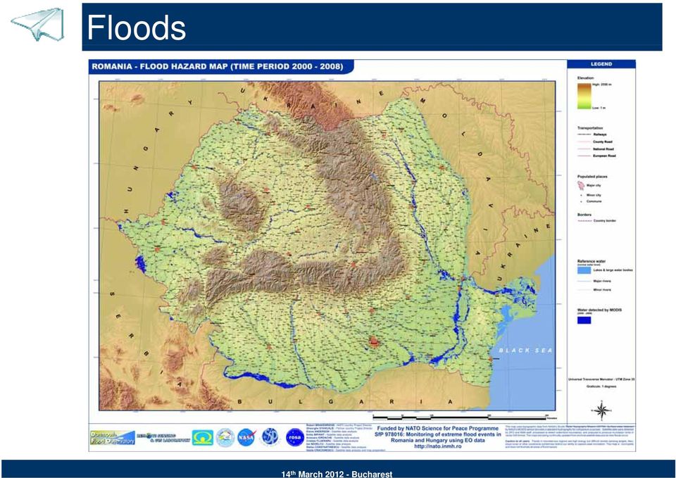
2 Floods Floods are the major disaster affecting many countries in the world year after year. From Romania perspective, floods are among the most hazardous natural disasters in terms of human suffering and economic losses. Major floods occurred in 2000, 2005, 2006, 2008 and 2010, the worst ones in more than 40 years, have affected large regions of Romania: in the Timis county (April 2005) over homes have been damaged or destroyed, people have been evacuated and about hectares of agricultural land flooded; in five counties situated in eastern Romania (July 2005) homes were inundated, people have been evacuated, 20 people were killed, hectares farmland flooded, 379 bridges damaged or destroyed; in 12 counties along the Danube (April 2006) homes were affected (1 049 completely destroyed), people evacuated, 5 people killed, hectares of land flooded; in six counties from the North-East part of Romania (July 2008) houses were affected (over 300 totallyt destroyed), d) people evacuated and hectares of agricultural land inundated. At the end of June 2010, heavy rainfalls caused severe floods and flash floods in the river basins Prut and Siret (East and Northeast of Romania). More than 20 people p were killed and hundreds were evacuated. Several roads and thousands of hectares of farmland were inundated.
 11 000 homes were inundated, 8")
3 Floods
4 Projects: Framework : NATO SfP , Monitoring of extreme flood events in Romania and Hungary using EO data : PNCDI2 SIGUR, Satellite Based Emergency Response Service : PNCDI2 RISCASAT, Development of New Satellite-Derived Products Adapted to Users Requirements for Hydro-Meteorological Risk Management : FP7 SAFER, Services and Applications For Emergency Response Partners: Romanian Space Agency National Meteorological Administration National Institute of Hydrology & Water Management Romanian Center for the Remote Sensing Use in Agriculture University Politehnica Bucharest Advanced Studies and Research Center Beneficiaries: General Inspectorate for Emergency Situations Ministry i of Environment and Sustainable Development Local county councils, prefectures, etc.

5 Service concept Various processing techniques (classification, geo- referencing, filtering, and photo-interpretation) are used to combine the optical and radar images and map the flooded areas.

6 Service history Version 1: started in 2005 Version 2: started in early 2007 Version 3: started in early 2010

7 Workflow

8 Flood image processing chain

9 Software architecture

10 Flood related products Near real-time flood mapping Non real-time flood mapping Maximum flood extend mapping Flooded area classification Flood evolution mapping Damage assessment maps & reports 2D Animations 3D Flythrough

11 Map example: Timis river 2005

12 Map example: Siret river 2005

13 Map example: Danube river 2006

14 Map example: Danube river 2006

15 Map example: Danube river 2006

16 Map example: Danube river 2006

17 Map example: Danube river 2006

18 Map example: Danube Delta

19 Map example: Animation

20 Map example: Prut river 2008

21 Map example: Siret river 2010
22 Map example: Siret river 2010
23 Map example: Siret river 2010
24 Integration with historical data
25 Water classification example
26 Post-crisis monitoring example
27 Validation example
28 Data access
29 Conclusions & future work Numbers: Service activations: : 82 products 2006: 124 products 2008: 39 products 2010: 41 products What's next: Extend the service to cover other types of disasters Dedicated geoportal Better communication with the end-users Identification of new data sources Further algorithm development and validation Find new financial opportunities
30 The end Thanks for your attention. Questions?
Global Flood Alert System (GFAS)
") An Introduction of Global Flood Alert System (GFAS) Kazuo UMEDA Director of 2 nd Research Department, Infrastructure Development Institute-JAPAN Target: Reduction of Human Loss World s s natural disaster
An Introduction of Global Flood Alert System (GFAS) Kazuo UMEDA Director of 2 nd Research Department, Infrastructure Development Institute-JAPAN Target: Reduction of Human Loss World s s natural disaster
End to End Multi Hazard Early Warning Systems By Curt Barrett Hydrometeorological Consultant
 End to End Multi Hazard Early Warning Systems By Curt Barrett Hydrometeorological Consultant Disaster Risk Management- East Asia and Pacific Experts Roundtable on Urban Flood Risk Management March 17,
Catchment and Lake Research
 LARS 2007 Catchment and Lake Research Flood Forecasting and Early Warning System (FFEWS) an Alternative Technology for Flood Management System and Damage Reduction in Ethiopia: A Concept Note Semu Ayalew
HYDROMETEOROLOGICAL AND MONITORING SERVICE
 Regional Association VI, Forum Hydrology, Koblenz May 8 10, 2012 MINISTRY OF EMERGENCY SITUATIONS OF ARMENIA ARMENIAN STATE HYDROMETEOROLOGICAL AND MONITORING SERVICE Amalya Misakyan THE STRUCTURE OF ARMSTATEHYDROMET
New challenges of water resources management: Title the future role of CHy
 New challenges of water resources management: Title the future role of CHy by Bruce Stewart* Karl Hofius in his article in this issue of the Bulletin entitled Evolving role of WMO in hydrology and water
Two messages... Council of Europe. Flood Research
 Bonn, 12 May 2003 Insurance and Maladaptation Professor David Crichton University College London Middlesex University, London University of Dundee, Scotland Fellow of the Chartered Insurance Institute
Eastern Caribbean Open-Source Geospatial Data Sharing and Management Workshop
 Eastern Caribbean Open-Source Geospatial Data Sharing and Management Workshop Data Collection and Management in the Caribbean Spice Island Resort, St. George s, Grenada October 6 7, 2011 Presented by:
Emergency Management Service. early warning FLOOD AND FIRE ALERTS. Space
 Emergency Management Service early warning FLOOD AND FIRE ALERTS Space 1 Copernicus at a Glance Copernicus is the European Union s Earth Observation programme: a user-driven space programme under civil
Disaster Risk Management: prevention and urgent repair procedures for infrastructure and facilities
 Disaster Risk Management: prevention and urgent repair procedures for infrastructure and facilities Jacob Greenstein Ph.D, PE, EGAT/ I&E EGAT workshop-december 2009 1 Natural disasters-new trends Natural
Flood Facts 2F.1. Flood Facts
 Flood Facts 2F.1 Engage Flood Facts To introduce students to the causes and effects of flooding in Western Australia. Flooding occurs in the Australian environment as part of the natural water or hydrologic
 Disaster Prevention Measures in Global-Local Context 4 th World Water Forum Dr. Yoshihiko Yamashita CTI Engineering Co., Ltd Association of Japanese Consulting Engineers Outline of Presentation Up-to to-date
Sex Male Date of birth 21/10/1977 Nationality Romanian. Business or sector: Education and Research
 Curriculum Vitae PERSONAL INFORMATION Ionut Ovejanu Sex Male Date of birth 21/10/1977 Nationality Romanian WORK EXPERIENCE 10/2012 TODAY Lecturer GIS databases, geospatial data infrastructure, and location
Nowcasting: analysis and up to 6 hours forecast
 Nowcasting: analysis and up to 6 hours forecast Very high resoultion in time and space Better than NWP Rapid update Application oriented NWP problems for 0 6 forecast: Incomplete physics Resolution space
Mortgage lending and flood insurance in Poland
 Mortgage lending and flood insurance in Poland 2011 Agenda 1. General information on mortgage lending in Poland 2. Mortgage lendings and insurance 3. Polish flood exposure 4. Recent Polish major floods
WELCOMES ALL THE ATTENDEES WATER UTILISATION, MEASUREMENT AND METHODOLOGIES
 SUTRON india WELCOMES ALL THE ATTENDEES WATER UTILISATION, MEASUREMENT AND ABOUT SUTRON USA Strong Corporation was founded in 1975 Sutron Operates in : Hydrological Meteorological Oceanic Aviation Real-Time
Complementary Additional Programme 2014-2015 / Concept note. South Sudan. 24 Months US$ 5,000,000
 Complementary Additional Programme 2014-2015 / Concept note Increasing Resilience to Floods in South Sudan Geographical scope/benefitting country(ies) Duration (in months) Name and Unit of project Officer
Application of Google Earth for flood disaster monitoring in 3D-GIS
 Disaster Management and Human Health Risk II 271 Application of Google Earth for flood disaster monitoring in 3D-GIS M. Mori & Y. L. Chan Department of Information and Computer Science, Kinki University,
Big Data Challenge: Mining Heterogeneous Data. Prof. Mihai Datcu. German Aerospace Center (DLR) Munich Aerospace Faculty
 Munich Aerospace Faculty") Big Data Challenge: Mining Heterogeneous Data Prof. Mihai Datcu German Aerospace Center (DLR) Munich Aerospace Faculty Sensing & Big Data Big Data: - Computer hardware and the Cloud - Storage Challenges
Big Data Challenge: Mining Heterogeneous Data Prof. Mihai Datcu German Aerospace Center (DLR) Munich Aerospace Faculty Sensing & Big Data Big Data: - Computer hardware and the Cloud - Storage Challenges
Flash Flood Guidance Systems
 Flash Flood Guidance Systems Introduction The Flash Flood Guidance System (FFGS) was designed and developed by the Hydrologic Research Center a non-profit public benefit corporation located in of San Diego,
A Road Map for Disaster Risk Management
 Towards a Safer Sri Lanka A Road Map for Disaster Risk Management December 2005 Disaster Management Centre Ministry of Disaster Management Government of Sri Lanka Supported by U N D P United Nations Development
Antecedent Conditions:
 Antecedent Conditions: Record to Near Record Heat occurred across Northeast & North Central Colorado September 2-8. A cold front moved across Northeast Colorado the morning of the 9 th, and deeper subtropical
FLOOD PROTECTION AND ECOSYSTEM SERVICES IN THE CHEHALIS RIVER BASIN. May 2010. Prepared by. for the. 2010 by Earth Economics
 FLOOD PROTECTION AND ECOSYSTEM SERVICES IN THE CHEHALIS RIVER BASIN May 2010 Prepared by for the Execubve Summary The Chehalis Basin experienced catastrophic flooding in 2007 and 2009. In response, the
Best Practice of Flood Hazard Map in Japan
 Best Practice of Flood Hazard Map in Japan 1. Hazard map in Japan There are about 1,500 municipalities in Japan, which need to prepare flood hazard map. 510 municipalities have already made and disclosed
Geospatial Information for disaster risk reduction and natural resources management. Rolando Ocampo Alcántar
 Geospatial Information for disaster risk reduction and natural resources management Rolando Ocampo Alcántar Content Background Geospatial Information for Disaster Management Risk Atlas Information Exchange
Application of Space Technology for Disaster monitoring and assessment current state in Vietnam
 Application of Space Technology for Disaster monitoring and assessment current state in Vietnam Lai Anh Khoi SPACE TECHNOLOGY INSTITUTE 8th GEOSS Asian Pacific Symposium Beijing, Sep. 09-11, 2015 Types
DESWAT project (Destructive Water Abatement and Control of Water Disasters)
") A new national hydrological forecast and warning system is now in advanced implementation phase, within the Romanian Waters National Administration, in the framework of DESWAT project. The main objectives
A new national hydrological forecast and warning system is now in advanced implementation phase, within the Romanian Waters National Administration, in the framework of DESWAT project. The main objectives
DEWETRA: la piattaforma nazionale per la condivisioni di dati, previsioni e procedure per le attivita di DRR
 Dipartimento della Protezione Civile Fondazione CIMA DEWETRA: la piattaforma nazionale per la condivisioni di dati, previsioni e procedure per le attivita di DRR G. Boni 2, P. Pagliara 1, A. Corina 1 1
EFAS European Flood Awareness System
 EFAS European Flood Awareness System http://www.efas.eu/ EFAS Partner Network The first operational hydrological network in Europe Cristina Alionte Eklund Coordinator EFAS Dissemination Center History
COASTAL MONITORING & OBSERVATIONS LESSON PLAN Do You Have Change?
 Coastal Change Analysis Lesson Plan COASTAL MONITORING & OBSERVATIONS LESSON PLAN Do You Have Change? NOS Topic Coastal Monitoring and Observations Theme Coastal Change Analysis Links to Overview Essays
IMPLEMENTATION AND FUNDING OF MEASURES IN SPAIN
 EURO-INBO, RT3 nov-2014 (Bucharest, RU) IMPLEMENTATION AND FUNDING OF MEASURES IN SPAIN Tatiana Ortega Gómez Júcar River Basin Authority INDEX Distribution of water competences in Spain The hydrological
Enabling Access to Environmental. on the Web
 ENVISION Overview Enabling Access to Environmental Models, Data, and Services on the Web Dumitru Roman dumitru.roman@sintef.no Bucharest, November 13, 2012 http://www.envision-project.eu/ ENVISION Motivation
Floods management in Europe : Results of the EC-Project PREVIEW. 2nd UN-SPIDER Workshop Bonn, October 14, 2008 Franz Jaskolla Infoterra GmbH
 Floods management in Europe : Results of the EC-Project PREVIEW 2nd UN-SPIDER Workshop Bonn, October 14, 2008 Franz Jaskolla Infoterra GmbH The Infoterra Group 100% subsidiary of Astrium European Group
FULL NAME INFORMATION WHICH COUNTRIES/REGIONS/AREAS ARE COVERED SHORT DESCRIPTION OF MEMBERS LOWER DANUBE EUROREGION
 LOWER DANUBE EUROREGION (RO/UA/MD) Member of AEBR since 2001 Association of European Border Regions (AEBR) (Region 134 on the AEBR map Cross-Border Cooperation Areas 2011 ) FULL NAME LOWER DANUBE EUROREGION
How To Manage A Flood In Mozambique
 Flood Risk Management in Mozambique and Sub-regional Trans-boundary Issues UNFCCC regional expert meeting on loss and damage in Addis Ababa, Ethiopia from 13 to 15 June 2012 Ron Cadribo, UNISDR DRR Advisor,
Flood After Fire Fact Sheet
 FACT SHEET Flood After Fire Fact Sheet Risks and Protection Floods are the most common and costly natural hazard in the nation. Whether caused by heavy rain, thunderstorms, or the tropical storms, the
Roadmap toward Effective Flood hazard Mapping in China. Concluding Report For
 Roadmap toward Effective Flood hazard Mapping in China Concluding Report For JICA region-focused training course on flood hazard mapping Oct. 31~ Dec. 3 2005 Prepared by Luo Xiaoqing Engineer, Office of
HAZARD RISK ASSESSMENT, MONITORING, MAINTENANCE AND MANAGEMENT SYSTEM (HAMMS) FOR LANDSLIDE AND FLOOD. Mohd. Nor Desa, Rohayu and Lariyah, UNITEN
 FOR LANDSLIDE AND FLOOD. Mohd. Nor Desa, Rohayu and Lariyah, UNITEN") HAZARD RISK ASSESSMENT, MONITORING, MAINTENANCE AND MANAGEMENT SYSTEM (HAMMS) FOR LANDSLIDE AND FLOOD Mohd. Nor Desa, Rohayu and Lariyah, UNITEN WHAT WE HAVE IN MIND AND FROM OUR PREVIOUS PROJECT CONTRIBUTION
HAZARD RISK ASSESSMENT, MONITORING, MAINTENANCE AND MANAGEMENT SYSTEM (HAMMS) FOR LANDSLIDE AND FLOOD Mohd. Nor Desa, Rohayu and Lariyah, UNITEN WHAT WE HAVE IN MIND AND FROM OUR PREVIOUS PROJECT CONTRIBUTION
Index Insurance in India
 Index Insurance in India Kolli N Rao, PhD Aon Benfield, India Indian Agriculture & Risks What s Index Insurance? Why Index Insurance? The Outline Architecture of Indian Crop Insurance Coverage: The Numbers
o Level: Leading to a Masters degree o Duration : One year (October September) o Partners: National Graduate Institute for Policy Studies (GRIPS)
 o Partners: National Graduate Institute for Policy Studies (GRIPS)") o Level: Leading to a Masters degree o Duration : One year (October September) o Partners: National Graduate Institute for Policy Studies (GRIPS) Degree awarding institution ICHARM Teaching, supervision
o Level: Leading to a Masters degree o Duration : One year (October September) o Partners: National Graduate Institute for Policy Studies (GRIPS) Degree awarding institution ICHARM Teaching, supervision
2015 Global Risk Assessment. Sahar Safaie Program Officer, UNISDR Risk Knowledge Section
 2015 Global Risk Assessment Sahar Safaie Program Officer, UNISDR Risk Knowledge Section Outline Global Assessment Report (GAR) evolution Global Risk Assessment for GAR15 Objective Scope Audience/Users
Lower Prut Floodplain - Ecological restoration of the Lower Prut Floodplain Natural Park LIFE05 NAT/RO/000155
 Lower Prut Floodplain - Ecological restoration of the Lower Prut Floodplain Natural Park LIFE05 NAT/RO/000155 Project description Environmental issues Beneficiaries Administrative data Read more Contact
Associated Programme on Flood Management: IFM HelpDesk, activities and outcomes
 WMO Seminar on: Integrated flood risk management in Sweden How to achieve it? Stockholm, Sweden, 12 November 2013 Associated Programme on Flood Management: IFM HelpDesk, activities and outcomes G. Teruggi
Preliminary advances in Climate Risk Management in China Meteorological Administration
 Preliminary advances in Climate Risk Management in China Meteorological Administration Gao Ge Guayaquil,Ecuador, Oct.2011 Contents China Framework of Climate Service Experience in Climate/disaster risk
How To Understand And Understand The Flood Risk Of Hoang Long River In Phuon Vietnam
 FLOOD HAZARD AND RISK ASSESSMENT OF HOANG LONG RIVER BASIN, VIETNAM VU Thanh Tu 1, Tawatchai TINGSANCHALI 2 1 Water Resources University, Assistant Professor, 175 Tay Son Street, Dong Da District, Hanoi,
Next Generation Flood Alert in Houston
 Next Generation Flood Alert in Houston Philip B. Bedient Civil and Environmental Eng., Rice University Houston, TX Major Causes of Urban Flooding (Excess Water that Inundates) Highly Developed (urbanized)
General Insurance - Domestic Insurance - Home Contents Storm water damage policy exclusion flood damage
 Determination Case number: 227307 General Insurance - Domestic Insurance - Home Contents Storm water damage policy exclusion flood damage 4 April 2011 Background 1. The Applicants insured their home contents
Three Risks, One Solution
 Romanian Natural Disaster Insurance Pool Three Risks, One Solution Romanian mandatory home insurance 22nd-23rd of June, 2015 Munich, Germany Nicoleta Radu-Neacsu CEO Strategy statement for PAID: effective
The following was presented at DMT 14 (June 1-4, 2014, Newark, DE).
.") DMT 2014 The following was presented at DMT 14 (June 1-4, 2014, Newark, DE). The contents are provisional and will be superseded by a paper in the DMT 14 Proceedings. See also presentations and Proceedings
DMT 2014 The following was presented at DMT 14 (June 1-4, 2014, Newark, DE). The contents are provisional and will be superseded by a paper in the DMT 14 Proceedings. See also presentations and Proceedings
CRS 610 Ventura County Flood Warning System Website
 CRS 610 Ventura County Flood Warning System Website Purpose This document gives instructions and a description of the information available via the Ventura County Watershed Protection District s (VCWPD)
Flooding Fast Facts. flooding), seismic events (tsunami) or large landslides (sometime also called tsunami).
, seismic events (tsunami) or large landslides (sometime also called tsunami).") Flooding Fast Facts What is a flood? Flooding is the unusual presence of water on land to a depth which affects normal activities. Flooding can arise from: Overflowing rivers (river flooding), Heavy rainfall
Flooding Fast Facts What is a flood? Flooding is the unusual presence of water on land to a depth which affects normal activities. Flooding can arise from: Overflowing rivers (river flooding), Heavy rainfall
An innovative approach to Floods and Fire Risk Assessment and Management: the FLIRE Project
 8 th International Conference of EWRA Water Resources Management in an Interdisciplinary and Changing Context 26-29 June 2013, Porto, Portugal An innovative approach to Floods and Fire Risk Assessment
MANAGEMENT AND PREVENTION OF NATURAL DISASTERS - WHAT ARE THE REQUIREMENTS FOR THE EFFECTIVE APPLICATION OF REMOTE SENSING?
 MANAGEMENT AND PREVENTION OF NATURAL DISASTERS - WHAT ARE THE REQUIREMENTS FOR THE EFFECTIVE APPLICATION OF REMOTE SENSING? Peter Zeil Center for Geoinformation Processing Salzburg ZGIS University of Salzburg
ROSA ESA - DLR Course 2009 RADAR REMOTE SENSING Day 4-5
 ROSA ESA - DLR Course 2009 RADAR REMOTE SENSING Day 4-5 Dr. Jan-Peter Mund, André Twele & Sandro Martinis German Remote Sensing Data Center (DFD) German Aerospace Center (DLR) RADAR REMOTE SENSING Introduction
MASENO UNIVERSITY OFFICE OF THE DEPUTY VICE-CHANCELLOR, PARTNERSHIPS, RESEARCH & INNOVATIONS
 MASENO UNIVERSITY OFFICE OF THE DEPUTY VICE-CHANCELLOR, PARTNERSHIPS, RESEARCH & INNOVATIONS Maseno University has received a research grant from the African Development Bank (AfDB) towards a project entitled
Discussion about the practicability of implementing flood risk. management and urban flood insurance in China. Longhua Gao, Xiaoqing Zhou
 Discussion about the practicability of implementing flood risk management and urban flood insurance in China Longhua Gao, Xiaoqing Zhou Abstract: This paper explains the flood risk management at first,
THE COMMODITY RISK MANAGEMENT GROUP WORLD BANK
 THE COMMODITY RISK MANAGEMENT GROUP WORLD BANK Agricultural Insurance: Scope and Limitations for Rural Risk Management 5 March 2009 Agenda The global market Products Organisation of agricultural insurance
Improved Warnings for Natural Hazards: A Prototype System for Southern California
 Improved Warnings for Natural Hazards: A Prototype System for Southern California Yehuda Bock Research Geodesist Scripps Institution of Oceanography University of California San Diego, La Jolla, Calif.
Comprehensive Flood Control Measures
 Comprehensive Flood Control Measures Tokyo Metropolitan Torrential Rain Measures Basic Policy Recently, local torrential rains occur frequently in part of the Tokyo metropolitan area. The extensive flood
Draft Dapto Flood Management Plan
 NATURE OF HAZARD Draft Dapto Flood Management Plan Since Dapto school has been established on the current site there have been two floods. The SES is responsible for responding to floods in NSW. During
LIVING WITH FLOOD IN THE MEKONG DELTA, VIETNAM. Tran Thi Trieu, Nguyen Hieu Trung, Le Anh Tuan
 LIVING WITH FLOOD IN THE MEKONG DELTA, VIETNAM Tran Thi Trieu, Nguyen Hieu Trung, Le Anh Tuan THE MEKONG RIVER DELTA Mekong River Delta is in the most southern of Vietnam. The MD is considered as a biggest
AFTER PHAILIN: UNDERSTANDING CYCLONE RISK IN INDIA
 AIR WHITE PAPER AFTER PHAILIN: UNDERSTANDING CYCLONE RISK IN INDIA In 2013, Phailin, the first major tropical cyclone to hit India since 1999, made landfall as a Category 4 storm near Gopalpur on India
City of Jakarta (Tanggerang) Total Greater Jakarta (Jabotabek) Area width 649.71 1294.38 3833.21 5777.30
 Total Greater Jakarta (Jabotabek) Area width 649.71 1294.38 3833.21 5777.30") 1. The Disaster A heavy rainfall during the period of Jan 29-Feb 2 2007 has caused flood in some areas in greater Jakarta area. Floods are recurring phenomena in Jakarta area, it has happened regularly
1. The Disaster A heavy rainfall during the period of Jan 29-Feb 2 2007 has caused flood in some areas in greater Jakarta area. Floods are recurring phenomena in Jakarta area, it has happened regularly
March 16, 2015 Susumu Tanaka NEC Corporation
 NEC s Comprehensive Disaster Management Solution and Lessons Learned from the Great East Japan Earthquake March 16, 2015 Susumu Tanaka NEC Corporation Flow of Disaster Management NEC Solution for Disaster
How To Develop A Cloud Based Image Water Level Gauge System
 Yongjeon Kim, Heesung Park, Chanjoo Lee, Donggu Kim, Myoungbae Seo River and Coastal Research Division Korea Institute of Construction Technology Gyeonggi-do, Korea {fwasu3ri, c0gnitum, kimdg, hspark90g,
Abstract. 1 Introduction
 Assessment of flood risks in polders along the Dutch lakes F. den Heijer* & A.P. de LoofP WL\delft hydraulics ^Ministry of Transport, Public Works and Water Management, Directorate General of Public Works
GMES in Poland: Achievements and Challanges. Marek Banaszkiewicz Space Research Centre of the Polish Academy of Sciences
 GMES in Poland: Achievements and Challanges Marek Banaszkiewicz Space Research Centre of the Polish Academy of Sciences GMES in Poland 2 Responsible Ministry: Higher Education and Science Cooperating Ministries:
Probability Magnitude/Severity Warning Time Duration CPRI Flood 3.25 2.88 2.50 3.13 3.01
 3.7.8 FLOOD Probability Magnitude/Severity Warning Time Duration CPRI Flood 3.25 2.88 2.50 3.13 3.01 Description Flooding is the most frequent and costly natural hazard in the United States. During the
Communications Systems Used in the USA TARNS. Chris Hill, Meteorologist in Charge (ret) National Weather Service Seattle, Washington, USA
 National Weather Service Seattle, Washington, USA") Communications Systems Used in the USA TARNS Chris Hill, Meteorologist in Charge (ret) National Weather Service Seattle, Washington, USA Washington Faces Many Non-Weather Hazards Earthquakes Tsunamis Terrorism
Communications Systems Used in the USA TARNS Chris Hill, Meteorologist in Charge (ret) National Weather Service Seattle, Washington, USA Washington Faces Many Non-Weather Hazards Earthquakes Tsunamis Terrorism
PHOTOGRAMMETRIC RESEARCH PROJECTS AT MICHIGAN TECH INTEGRATED GEOSPATIAL TECHNOLOGY PROGRAM. elevin@mtu.edu. tellidis@mtu.edu. kvtakala@mtu.
 PHOTOGRAMMETRIC RESEARCH PROJECTS AT MICHIGAN TECH INTEGRATED GEOSPATIAL TECHNOLOGY PROGRAM Eugene Levin a, Ioakeim Tellidis b, Kevin Takala c a Michigan Technological University,1400 Townsend drive, Houghton
River Management 2013 Colorado Flood
 River Management 2013 Colorado Flood Damages, Countermeasures, Socio-Economic Impacts Miles Blair, Allen Chestnut, Hwayoung Kim, & Caroline Ubing CIVE 717 Spring 2014 Flood Statistics Sept 9 th 16 th,
FLOOD RISK RECENT TRENDS AND POLICY RESPONSES
 FLOOD RISK RECENT TRENDS AND POLICY RESPONSES DEVELOPING WESTMINSTER S LOCAL PLAN Booklet No. 2 LDF Consultation - CMP Revision November 2013 INTRODUCTION CLLR ROBERT DAVIS Westminster is at risk of flooding
BRIEFING NOTE. Assessment of Innovative Approaches to Flood Risk Management and Financing in Agriculture: The Thailand Case Study 1
 Public Disclosure Authorized Public Disclosure Authorized BRIEFING NOTE Assessment of Innovative Approaches to Flood Risk Management and Financing in Agriculture: The Thailand Case Study 1 Public Disclosure
The Effects of Climate Change on Water Resources in Spain
 Marqués de Leganés 12-28004 Madrid Tel: 915312739 Fax: 915312611 secretaria@ecologistasenaccion.org www.ecologistasenaccion.org The Effects of Climate Change on Water Resources in Spain In order to achieve
The Role of GARNET-E in supporting Disaster Management and Emergency Response for Africa
 The Role of GARNET-E in supporting Disaster Management and Emergency Response for Africa Presented by Prof. Isi Ikhuoria Regional Centre for Training in Aerial Surveys (RECTAS), Nigeria at The 9 th EUMETSAT
Real Time Flood Alert System (RTFAS) for Puerto Rico
 for Puerto Rico") Prepared in cooperation with the Puerto Rico Emergency Management Agency (PREMA) Real Time Flood Alert System (RTFAS) for Puerto Rico Overview The Real Time Flood Alert System is a web-based computer program,
Prepared in cooperation with the Puerto Rico Emergency Management Agency (PREMA) Real Time Flood Alert System (RTFAS) for Puerto Rico Overview The Real Time Flood Alert System is a web-based computer program,
Project acronym: KnoCH. Project type: Leonardo da Vinci, Transfer of Innovation. Project duration: 24 months (01.01.2012 31.12.
 Project title: Development of knowledge centers for life-long learning by involving of specialists and decision makers in flood risk management using advanced Hydroinformatic tools Project acronym: KnoCH
Point Clouds: Big Data, Simple Solutions. Mike Lane
 Point Clouds: Big Data, Simple Solutions Mike Lane Light Detection and Ranging Point Cloud is the Third Type of Data Vector Point Measurements and Contours Sparse, highly irregularly spaced X,Y,Z values
SUMMARY OF IMPACT OF HURRICANE SANDY" ON CDEMA PARTICIPATING STATES
 SUMMARY OF IMPACT OF HURRICANE SANDY" ON CDEMA PARTICIPATING STATES Response Actions, Recovery and Report Prepared by the Coordinating Unit of the Caribbean Disaster Emergency Management Agency (CDEMA)
Flood Mitigation and Management in Bangkok Metropolitan Area
 กร งเทพมหานคร Flood Mitigation and Management in Bangkok Metropolitan Area Present By Mr. Kriangkrai Phamornpol Department of Drainage and Sewerage Bangkok Metropolitan Administration 1 Flood Mitigation
MCII. Rethinking the role of Insurance: Driving transformation in the context of climate change related loss and damage
 MCII Rethinking the role of Insurance: Driving transformation in the context of climate change related loss and damage Dr. Koko Warner, Executive Director hosted at UNU-EHS Session IV: Implications of
Floods as a One Health Problem
 Floods as a One Health Problem Learning Objec7ves At the end of the session par7cipants will be able to: Understand how floods (and other disasters) can be viewed as a One Health problem Describe how climate
JAMAICA. Agricultural Insurance: Scope and Limitations for Weather Risk Management. Diego Arias Economist. 18 June 2009
 JAMAICA Agricultural Insurance: Scope and Limitations for Weather Risk Management Diego Arias Economist 18 June 2009 Financed partly by the AAACP EU Support to the Caribbean Agenda The global market Products
Istanbul Technical University-Center for Satellite Communications and Remote Sensing (ITU-CSCRS)
") Istanbul Technical University-Center for Satellite Communications and Remote Sensing (ITU-CSCRS) Istanbul Technical University, Center for Satellite Communications and Remote Sensing (ITU-CSCRS) was originally
Istanbul Technical University-Center for Satellite Communications and Remote Sensing (ITU-CSCRS) Istanbul Technical University, Center for Satellite Communications and Remote Sensing (ITU-CSCRS) was originally
Basic system of measures for flood damage mitigation in Japan. Preparedness for major floods
 Basic system of measures for flood damage mitigation in Japan Preparedness for major floods Past major floods and state-level efforts Role of the 2 MLIT's disaster prevention efforts Disaster prevention
SCHOOL RISK MANAGEMENT PLANNING LEVERAGING DATA, TOOLS AND PARTNERSHIPS
 School Facilities Safer School Risk Management Viewer School Risk Management Plan SCHOOL RISK MANAGEMENT PLANNING LEVERAGING DATA, TOOLS AND PARTNERSHIPS December 4, 2013 John Dorman North Carolina Emergency
Multi-Jurisdictional Hazard Mitigation Plan
 Flooding General Flooding is the leading cause of death among all types of natural disasters throughout the United States, with its ability to roll boulders the size of cars, tear out trees, and destroy
Innovative E-Government Best Practices in Early Warning System for Disaster Risk Management: Bangladesh Experience
 Innovative E-Government Best Practices in Early Warning System for Disaster Risk Management: Bangladesh Experience Dilder Ahmed (Joint Secretary) Project Director ECRRP-D-1 Department of Disaster Management.
Flood Zone Investigation by using Satellite and Aerial Imagery
 Flood Zone Investigation by using Satellite and Aerial Imagery Younes Daneshbod Islamic Azad University-Arsanjan branch Daneshgah Boulevard, Islamid Azad University, Arsnjan, Iran Email: daneshbod@gmail.com
Flood Insurance Guide THE INSURANCE AGENT S ROLE IN PROTECTING HOMEOWNERS
 Flood Insurance Guide THE INSURANCE AGENT S ROLE IN PROTECTING HOMEOWNERS Table of Contents Introduction... 3 Your Clients Need Flood Insurance... 5 For Most of the U.S., Flood Insurance Is Highly Affordable...
Flood warnings. What they are and what they do. A guide to the Environment Agency s flood warning codes
 Flood warnings What they are and what they do A guide to the Environment Agency s flood warning codes We are the Environment Agency. It s our job to look after your environment and make it a better place
Flood Damage Statistics in Japan - What is required for mainstreaming DM?
 Flood Damage Statistics in Japan - What is required for mainstreaming DM? 30 September 2013 Yusuke AMANO Director, International Affairs Office Water and Disaster Management Bureau Ministry of Land, Infrastructure,
REPUBLIC OF TURKEY MINISTRY OF FORESTRY AND WATER AFFAIRS
 REPUBLIC OF TURKEY MINISTRY OF FORESTRY AND WATER AFFAIRS Turkey s position in the World Prof. Dr. Veysel EROĞLU Minister of Forestry and Water Affairs The Ministry of Forestry and Water Affairs, formerly
Matsu: An Elastic Cloud Connected to a SensorWeb for Disaster. (Session 12F Working Group: Cloud Computing for Spacecraft Operations)
") Matsu: An Elastic Cloud Connected to a SensorWeb for Disaster Response (Session 12F Working Group: Cloud Computing for Spacecraft Operations) Daniel Mandl - NASA/GSFC 3/2/11 1 SensorWeb High Level Architecture
Matsu: An Elastic Cloud Connected to a SensorWeb for Disaster Response (Session 12F Working Group: Cloud Computing for Spacecraft Operations) Daniel Mandl - NASA/GSFC 3/2/11 1 SensorWeb High Level Architecture
Stormwater Control Measures for Tokyo
 Stormwater Control Measures for Tokyo M. Sugai* *Planning Section, Planning and Coordination Division, Bureau of Sewerage, Tokyo Metropolitan Government, 2-8-1 Nishi-Shinjuku, Shinjuku-ku, Tokyo 163-8001
A disaster occurs at the point of contact between social activities and a natural phenomenon of unusual scale.
 Hazard Mapping and Vulnerability Assessment Mr. Toshiaki Udono Senior Project Manager, Kansai Division, PASCO Corporation, Japan Mr. Awadh Kishor Sah Project Manager, Project Implementation Department,
OUTLINES. Earth Observation Satellite Program of Vietnam and applications for disaster management
 UNESCAP ICC & HLDM Meetings, Bangkok 26 28/11/2013 Earth Observation Satellite Program of Vietnam and applications for disaster management OUTLINES 1. VNREDSat-1 (VAST*) - Optical 2. VNREDSat-1B (VAST)
History of flooding. 12 Flood Management and Drainage Strategy. Riverine flooding
 History of flooding Riverine flooding The original settlement of Melbourne was situated in a basin intersected by the paths of the Yarra and Maribyrnong Rivers. Many of the early recorded floods occurred
APPLICATION OF SATELLITE DATA FOR IMPROVED FLOOD FORECASTING AND MAPPING
 4 th International Symposium on Flood Defence: Managing Flood Risk, Reliability and Vulnerability Toronto, Ontario, Canada, May 6-8, 2008 APPLICATION OF SATELLITE DATA FOR IMPROVED FLOOD FORECASTING AND
Copyright 2005-2010 Soleran, Inc. esalestrack On-Demand CRM. Trademarks and all rights reserved. esalestrack is a Soleran product Privacy Statement

Real-time Global Flood Monitoring and Forecasting using an Enhanced Land Surface Model with Satellite and NWP model based Precipitation
 Real-time Global Flood Monitoring and Forecasting using an Enhanced Land Surface Model with Satellite and NWP model based Precipitation Huan Wu,2, Robert F. Adler, 2, Yudong Tian, 2, George J. Huffman