Matsu: An Elastic Cloud Connected to a SensorWeb for Disaster. (Session 12F Working Group: Cloud Computing for Spacecraft Operations)
|
|
|
- Jared Little
- 8 years ago
- Views:
Transcription
1 Matsu: An Elastic Cloud Connected to a SensorWeb for Disaster Response (Session 12F Working Group: Cloud Computing for Spacecraft Operations) Daniel Mandl - NASA/GSFC 3/2/11 1
 Daniel Mandl -")
2 SensorWeb High Level Architecture floods, fires, volcanoes etc Data Processing Node SensorML Capabilities Documents Web Coordinate Transformation Service (WCTS) Web Processing Service (WPS) Web Coverage Service (WCS) SensorML SensorML SensorML Sensor Data Products RSS Feeds Internet OpenID 2.0 Node Sensor Data In-situ ode UAV Se ensor Data N EO-1 Satellite Satellite sensor data prod duct L1G Capabilities Documents Web Feature SAS Service (WFS) Sensor Planning Service SOS (SPS) Sensor Alert WFS Service (SAS) Sensor Observation SPS Service (SOS) Satellite Data Node GeoBPMS Workflow s
 Sensor Planning Service SOS (SPS) Sensor Alert WFS Service (SAS) Sensor Observation SPS Service (SOS) Satellite Data Node GeoBPMS")
3 Old Way of Doing Things with EO-1 Level 0 processed science data Level 0 Processing at GSFC raw science data via X-band JPL White Sands Scheduling group station in-views times USGS Flight Dynamics Support Sys tracking data contact times overflight times Non-GSFC User commands GSFC Mission Planner Level el 1 & higher processed science data products Flight Ops Daily plan Mission Ops Planning & Sched Sys ASIST Telemetry & Command Sys telemetry Daily activity plan Science Validation Team targets Ops engineering requests De-conflicted, manually selected weekly schedule User interface Technology Validation Team USGS target activities requests Planning Committee Deputy Mission Scientist Mission Sys Engineer Mission Planner USGS Representative Alaska, Norway, Wallops Ground Stations RF Link cmd/ telemetry Phase 1 Standard Ops Architecture November 2000

4 Step 1 Improvement for EO-1 USGS Level 0 processed science data Level 0 Processing Level 0 at GSFC Processing at GSFC raw science data via X-band JPL White Sands Scheduling group station in-views times Alaska, Norway, Wallops Ground Stations USGS Flight Dynamics Support Sys tracking data contact times overflight times GSFC targets Mission Planner Level el 1 & higher processed science data products Flight Ops Daily plan Mission Ops Planning & Sched Sys Daily activity plan ASIST Telemetry & goals Command Sys User interface Science Technology Validation Validation Team Team targets activities USGS target JPL requests users Ops engineering requests De-conflicted, manually selected weekly schedule (backup approach & maneuvers) Planning Committee Deputy Mission Scientist Mission i Sys Engineer Mission Planner USGS Representative JPL Representation ASPEN Ground Planner with Web Interface De-conflicted, manually generated replacement record file Non-GSFC Commands, User goals telemetry goals Onboard EO-1 Science RF Link science data Processing cmd, goals/ GSFC OpenID Provider cmds (OP) telemetry Server SCL-Meta- CASPER command Onboard controller Planner activities Phase 2 Add Onboard Autonomy October 2003
 Planning Committee Deputy Mission Scientist Mission i")
5 Level 0 science data Level 0 Processing Level 0 at GSFC Processing at GSFC raw science data via X-band Step 2 Improvement for EO-1 USGS USGS White Sands Scheduling group station in-views times Alaska, Norway, Wallops Ground Stations Flight Dynamics Support Sys tracking data JPL Sensor Observation Service(SOS) for Hyperion JPL Web Processing Service(WPS) for Hyperion GSFC Sensor Observation Service(SOS) for ALI GSFC Web Processing Service(WPS) for ALI contact times overflight times FOT Mission Planner Daily plan backup Mission Ops Planning & Sched Sys Daily activity plan goals ASIST Telemetry & Command Sys JPL users targets Auto grnd sensor triggers USGS target requests L1R, L1G L2 Products L1R, L1G Disaster target requests L2 Products JPL Sensor Planning Service (SPS) Mission Science Office NASA Investigator targets ASPEN Ground Planner with Web Interface Technology Validation activities Mission Systems Engineer External and Internal User targets GSFC GeoBPMS (Secure Web Interface) Misc targets Non-GSFC Commands, User goals telemetry goals Onboard EO-1 Science RF Link science data Processing cmd, goals/ GSFC OpenID Provider cmds (OP) telemetry Server SCL-Meta- CASPER command Onboard controller Planner activities Phase 3 Add Web Services October 2008
 Mission")
6 Hyperion and ALI Level 0 Processed data from GSFC, building 3 server Step 3 Improvement for EO-1 - Overview External users, especially international (e.g. disaster workers) NASA Investigators Technologists 80 Gbps Starlight 100 Gigabit Ethernet Exchange Level 1R and Level 1G Processing for ALI & Hyperion Atmospheric Correction for ALI & Hyperion Web Coverage Processing Service (WCPS) to enable users to customize Level 2 products Amazon Elastic Cloud SW 300+ core processors 80 Tbytes of storage 80 Gbps connection to GSFC At Univ of Illinois at Chicago Supplied by Open Cloud Consortium Virtual Machines (VM) & http server to VM s Nambia Flood Dashboard 2 year data product archive Phase 3 Add Elastic Cloud Ongoing Feb 2011
 to enable users to customize Level 2 products Amazon Elastic Cloud SW 300+ core processors 80 Tbytes of storage 80 Gbps connection")
7 Transformation to On-Demand Product Cloud Part 1 EO-1 Data Product Pipeline EO-1 Level 0 Processor Server Storage 2 years Hyperion & ALI Level 1R EO-1 Level 1 Processor Service Hyperion Level 1R ALI Level 1R EO-1 Level 1 Geospatially Corrected Service Hyperion Level 1G ALI Level 1G EO-1 ALI Atmospheric Correction FLAASH Service EO-1 Hyperion Atmospheric Correction - FLAASH Service EO-1 Hyperion Atmospheric Correction ATREM Service Storage 2years Hyperion & ALI Level 1R and Level 1G AC Storage 2 years Hyperion & ALI Level 1G Storage Available Algorithms algorithms WCPS Algorithm Generation Service WCPS Runtime Service Storage 2 years User Defined L2 Products Generate a new product with this new algorithm Select algorithm & data to run against Phase 3 Add Elastic Cloud Ongoing Feb 2011

8 CREST Hydrological Model TRMM based Global Rainfall Estimates Radarsat Images On-Demand Product Cloud Part 2 Flood Dashboard (Matsu) 6 Namibian River Gauge Stations - Daily Measurements MODIS Daily Flood Extent t Map Namibia River Gauge Storage 2 years Data base Hyperion & ALI Level 1R Global Disaster and Alert and Coordination System (GDACS) Storage 2 years Hyperion & ALI Level 1G Storage 2years Hyperion & ALI Level 1R and Level 1G AC Flood Dashboard Display Service - Mashup - Google Maps Inset - Plot Package Storage 2 years User Defined L2 Products e.g. EO-1 Flood Mask http server Phase 3 Add Elastic Cloud Ongoing Feb 2011

9 Experimental Namibian Flood SensorWeb Webpage Flood Dashboard Note blue bars indicating a surge of rainfall upstream Then a flood wave appears downstream at Rundu river gauge days later Zambezi basin consisting of upper, middle and lower catchments 9 Namibia Short Term Pilot for 2010 Colored areas represent catchments where rainfall collects and drains to river basins River gauges displayed as small circles Detailed measurements are available on the display by clicking on the river gauge stations. This display can be viewed and manipulated at: and

10 Shanalumono River Gauge Station and Part of Community Prone to Flooding Downstream

11 Experimental Namibian Flood SensorWeb Webpage View of Available Envisat & EO-1 Overlay Images Flood Dashboard Experimental TRMM-based Flood Forecast Products Envisat SAR and EO-1 Optical Image Overlays

12 Estimated Rainfall Webpage Based on TRMM Data Experimented with ihvarious hydrometeorolgical information for flood forecasting models remote sensing rainfall estimates 24 February 2010 NASA Servir Africa red is > 35 mm

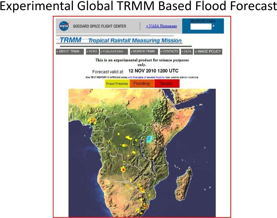
13 Experimental Global TRMM Based Flood Forecast
14 Experimental Flood Extent Data Product Derived from MODIS First product out of automated MODIS flood extent map pipeline prototype. Used data from March 2009 when large floods occurred to test.

15 Recent MODIS Daily Flood Extent Area toured on January 2011 trip Recent flooded area

16 Sample of Planned Addition of Higher Resolution Flood Product Overlay Using EO-1

17 Mashup of Satellite Data and River Gauge Data Using Namibia2 (Google Earth Version) Webpage Tool Zambia water lines from old database Lower Zambezi catchment Multiyear river gauge measurements NORMAL, 2009 AND 2010 WATER LEVELS AT KATIMA MULILO UPDATE 23 FEBRUARY normal Envisat swath EO-1 Data March 2009 Radarsat Data March 25, Envisat Data March Jan 21 Jan 10 Feb 2 Mar 22 Mar 11 Apr

18 Mock up of Revised River Gauge Plot Page Various flood models such as CREST model (Univ. of Oklahoma) Rainfall prediction From GEOS-5 TRMM based daily rainfall estimates
 Rainfall prediction From")
19 Sample Display of Multi-year Satellite Measurements (in month of March) of Katima Mulilo Linked to JRC Via Namibia Flood Mashup Based on Terra AMSR-E Microwave Instrument

20 Sample Alert During Pilot Namibia daily flood bulletin 03 March 2010: There have again been heavy rains in parts of the Zambezi catchment. See attached NASA map. The waterlevels at Chavuma started rising again. See attached graph. Our forecast remains that the Katima Mulilo waterlevels are heading for 7 m by mid March For perspective, the flood would be: similar to 2007 higher than 2008 lower than 2009 But much will depend don the rains and the catchment response in the coming weeks.

21 Sample Time Sequence Flood Map Generated by Unosat, Derived from Multiple Satellite Data Sets Vision is to generate similar product automatically when floods predicted and pair them with river gauge measurements
22 Conclusion Combining Sensorwebs with an elastic computation cloud enables surge capacity for disasters by enabling parallel processing of various algorithms and other processes within the cloud Elastic cloud provides work space for user to customize their experience instead of a preset outputs 22
A Namibia Early Flood Warning System A CEOS Pilot Project
 A Namibia Early Flood Warning System A CEOS Pilot Project Dan Mandl NASA/GSFC Stu Frye/SGT, Rob Sohlberg/Univ. of Md, Pat Cappelaere/SGT, Matt Handy/NASA/GSFC, Robert Grossman/Univ. of Chicago, Joshua
Overview on Namibian Flood SensorWeb Pilot Project stuart.frye@nasa.gov October 22, 2009
 Overview on Namibian Flood SensorWeb Pilot Project stuart.frye@nasa.gov October 22, 2009 1 Goal is to visualize available satellite data and possible future satellite data in an area of interest and a
Sensor Webs with a Service-Oriented Architecture for On-demand Science Products
 Invited Paper s with a -Oriented Architecture for On-demand Science Products Daniel Mandl a, Rob Sohlberg b, Chris Justice b, Stephen Ungar a, Troy Ames a, Stuart Frye c, Steve Chien d, Daniel Tran d,
Monitoring a Changing Environment with Synthetic Aperture Radar. Alaska Satellite Facility National Park Service Don Atwood
 Monitoring a Changing Environment with Synthetic Aperture Radar Don Atwood Alaska Satellite Facility 1 Entering the SAR Age 2 SAR Satellites RADARSAT-1 Launched 1995 by CSA 5.6 cm (C-Band) HH Polarization
The Matsu Wheel: A Cloud-based Scanning Framework for Analyzing Large Volumes of Hyperspectral Data
 The Matsu Wheel: A Cloud-based Scanning Framework for Analyzing Large Volumes of Hyperspectral Data Maria Patterson, PhD Open Science Data Cloud Center for Data Intensive Science (CDIS) University of Chicago
Asynchronous Data Mining Tools at the GES-DISC
 Asynchronous Data Mining Tools at the GES-DISC Long B. Pham, Stephen W. Berrick, Christopher S. Lynnes and Eunice K. Eng NASA Goddard Space Flight Center Distributed Active Archive Center Introduction
Integrated Risk Management System Components in the GEO Architecture Implementation Pilot Phase 2 (AIP-2)
") Meraka Institute ICT for Earth Observation PO Box 395 Pretoria 0001, Gauteng, South Africa Telephone: +27 12 841 3028 Facsimile: +27 12 841 4720 University of KwaZulu- Natal School of Computer Science
Meraka Institute ICT for Earth Observation PO Box 395 Pretoria 0001, Gauteng, South Africa Telephone: +27 12 841 3028 Facsimile: +27 12 841 4720 University of KwaZulu- Natal School of Computer Science
Satellite Snow Monitoring Activities Project CRYOLAND
 Satellite Snow Monitoring Activities Project CRYOLAND Background material for participants to the Workshop on European Snow Monitoring Perspectives, Darmstadt, 4-5 December 2012. CryoLand provides Snow,
NASA s Big Data Challenges in Climate Science
 NASA s Big Data Challenges in Climate Science Tsengdar Lee, Ph.D. High-end Computing Program Manager NASA Headquarters Presented at IEEE Big Data 2014 Workshop October 29, 2014 1 2 7-km GEOS-5 Nature Run
Development of an Integrated Data Product for Hawaii Climate
 Development of an Integrated Data Product for Hawaii Climate Jan Hafner, Shang-Ping Xie (PI)(IPRC/SOEST U. of Hawaii) Yi-Leng Chen (Co-I) (Meteorology Dept. Univ. of Hawaii) contribution Georgette Holmes
CEOS Water Portal Status Update
 CEOS Water Portal Status Update WGISS-33 Tokyo, Japan April 23-27, 2012 JAXA/Mission Operations System Office Satoko Miura/ Atsushi Kawai Update since WGISS-32 New features Compare service for MOLTS data
George Mason University (GMU)
") George Mason University (GMU) Center for Spatial Information Science and Systems Organization (CSISS) 4400 University Drive, MSN 6E1 George Mason University Fairfax, VA 22030, USA Telephone: +1 703 993
George Mason University (GMU) Center for Spatial Information Science and Systems Organization (CSISS) 4400 University Drive, MSN 6E1 George Mason University Fairfax, VA 22030, USA Telephone: +1 703 993
FlowViewer. Maintaining NASA s Earth Science Traffic Situational Awareness
 FlowViewer Maintaining NASA s Earth Science Traffic Situational Awareness Graphic credit: Arizona/New Mexico Fire Imagery, USDA Forest Service; Remote Sensing Application Center; Image acquired from Aqua
The NASA NEESPI Data Portal to Support Studies of Climate and Environmental Changes in Non-boreal Europe
 The NASA NEESPI Data Portal to Support Studies of Climate and Environmental Changes in Non-boreal Europe Suhung Shen NASA Goddard Space Flight Center/George Mason University Gregory Leptoukh, Tatiana Loboda,
Tom De Groeve a a Joint Research Centre of the European Commission, Ispra, Via. Fermi 2147, 21020, Ispra, Italy
 This article was downloaded by: [University of Colorado at Boulder Libraries] On: 02 August 2012, At: 12:22 Publisher: Taylor & Francis Informa Ltd Registered in England and Wales Registered Number: 1072954
Satellite Products and Dissemination: Visualization and Data Access
 Satellite Products and Dissemination: Visualization and Data Access Gregory Leptoukh GES DISC, NASA GSFC Dana Ostrenga GES DISC, NASA GSFC Introduction The Goddard Earth Sciences Data and Information Services
Suomi / NPP Mission Applications Workshop Meeting Summary
 Suomi / NPP Mission Applications Workshop Meeting Summary Westin City Center, Washington, DC June 21-22, 2012 Draft Report (updated March 12, 2013) I. Background The Suomi National Polar- orbiting Partnership
Overview of NASA Applied Remote Sensing Training Program on Water Resources and Disaster Management
 Overview of NASA Applied Remote Sensing Training Program on Water Resources and Disaster Management ARSET Applied Remote SEnsing Training A project of NASA Applied Sciences Outline About ARSET ARSET Trainings
Real-time Global Flood Monitoring and Forecasting using an Enhanced Land Surface Model with Satellite and NWP model based Precipitation
 Real-time Global Flood Monitoring and Forecasting using an Enhanced Land Surface Model with Satellite and NWP model based Precipitation Huan Wu,2, Robert F. Adler, 2, Yudong Tian, 2, George J. Huffman
Review for Introduction to Remote Sensing: Science Concepts and Technology
 Review for Introduction to Remote Sensing: Science Concepts and Technology Ann Johnson Associate Director ann@baremt.com Funded by National Science Foundation Advanced Technological Education program [DUE
TRMM and Other Global Precipitation Products and Data Services at NASA GES DISC. Zhong Liu George Mason University and NASA GES DISC
 TRMM and Other Global Precipitation Products and Data Services at NASA GES DISC Zhong Liu George Mason University and NASA GES DISC Outline Introduction of data and services at GES DISC TRMM and other
VITO Centre of Image Processing
 07/11/2013 VITO Centre of Image Processing Towards an Improved Scientific Exploitation of EO Data Sources in Support of Vegetation Monitoring Erwin Goor, VITO nv Outline» Introduction» The role & and objectives
Monitoring and Early Management of Emergences: New Instruments
 Monitoring and Early Management of Emergences: New Instruments Daniele Caviglia, DITEN - University of Genoa Domenico Sguerso, DICCA - University of Genoa Bianca Federici, DICCA - University of Genoa Andrea
Sodankylä National Satellite Data Center (NSDC): Current and Future Satellite Missions and Products
: Current and Future Satellite Missions and Products") Sodankylä National Satellite Data Center (NSDC): Current and Future Satellite Missions and Products Timo Ryyppö, CSPP Users Group Meeting 2015 Content Introduction to Sodankylä site Facilities Satellites
Sodankylä National Satellite Data Center (NSDC): Current and Future Satellite Missions and Products Timo Ryyppö, CSPP Users Group Meeting 2015 Content Introduction to Sodankylä site Facilities Satellites
Global Flood Alert System (GFAS)
") An Introduction of Global Flood Alert System (GFAS) Kazuo UMEDA Director of 2 nd Research Department, Infrastructure Development Institute-JAPAN Target: Reduction of Human Loss World s s natural disaster
An Introduction of Global Flood Alert System (GFAS) Kazuo UMEDA Director of 2 nd Research Department, Infrastructure Development Institute-JAPAN Target: Reduction of Human Loss World s s natural disaster
CRS 610 Ventura County Flood Warning System Website
 CRS 610 Ventura County Flood Warning System Website Purpose This document gives instructions and a description of the information available via the Ventura County Watershed Protection District s (VCWPD)
Using Commercial Software to Enhance Commercial Imaging Acquisition
 Using Commercial Software to Enhance Commercial Imaging Acquisition Adam Gorski, Analytical Graphics, Inc., Exton, PA USA, Email: agorski@agi.com April 2011 Abstract This paper documents the ways commercially
Experimenting with Sensor Webs Using Earth Observing 1
 . Experimenting with Sensor Webs Using Earth Observing 1 Dan Mandl Code 584 NASNGSFC Greenbelt, Md. 20771 301-286-4323 Daniel.J.Mandl@,nasa.gov Abstract- The New Millennium Program ( ) Earth observing
NIGERIA EARTH OBSERVATION SATELLITE PROJECT
 NIGERIA EARTH OBSERVATION SATELLITE PROJECT By SIEDU ONAILO MOHAMMED, Ph.D. Director General National Space Research and Development Agency Presentation at the DMC and NovaSAR International Conference
Machine-to-Machine Management System. Datasheet. Models: mport, mport-s, mpower, mpower Mini, mpower Pro, mfi-cs, mfi-ds, mfi-ths, mfi-msc, mfi-msw
 Machine-to-Machine Management System Models: mport, mport-s, mpower, mpower Mini, mpower Pro, mfi-cs, mfi-ds, mfi-ths, mfi-msc, mfi-msw Automated Machine Control Sensor Data Collection and Analytics Plug
End to End Multi Hazard Early Warning Systems By Curt Barrett Hydrometeorological Consultant
 End to End Multi Hazard Early Warning Systems By Curt Barrett Hydrometeorological Consultant Disaster Risk Management- East Asia and Pacific Experts Roundtable on Urban Flood Risk Management March 17,
NASA Earth System Science: Structure and data centers
 SUPPLEMENT MATERIALS NASA Earth System Science: Structure and data centers NASA http://nasa.gov/ NASA Mission Directorates Aeronautics Research Exploration Systems Science http://nasascience.nasa.gov/
NASA's Strategy and Activities in Server Side Analytics
 NASA's Strategy and Activities in Server Side Analytics Tsengdar Lee, Ph.D. High-end Computing Program Manager NASA Headquarters Presented at the ESGF/UVCDAT Conference Lawrence Livermore National Laboratory
Monitoring Soil Moisture from Space. Dr. Heather McNairn Science and Technology Branch Agriculture and Agri-Food Canada heather.mcnairn@agr.gc.
 Monitoring Soil Moisture from Space Dr. Heather McNairn Science and Technology Branch Agriculture and Agri-Food Canada heather.mcnairn@agr.gc.ca What is Remote Sensing? Scientists turn the raw data collected
Global Flood Partnership
 Global Flood Partnership Global tools and services for managing flood risk and emergencies Dr. Tom De Groeve Joint Research Centre of the European Commission tom.de-groeve@jrc.ec.europe.eu State of global
A tiered reconnaissance approach toward flood monitoring utilising multi-source radar and optical data
 5 th International Workshop on Remote Sensing for Disaster Response A tiered reconnaissance approach toward flood monitoring utilising multi-source radar and optical data Anneley McMillan Dr. Beverley
Cloud-based Geospatial Data services and analysis
 Cloud-based Geospatial Data services and analysis Xuezhi Wang Scientific Data Center Computer Network Information Center Chinese Academy of Sciences 2014-08-25 Outlines 1 Introduction of Geospatial Data
Joint Polar Satellite System (JPSS)
") Joint Polar Satellite System (JPSS) John Furgerson, User Liaison Joint Polar Satellite System National Environmental Satellite, Data, and Information Service National Oceanic and Atmospheric Administration
Joint Polar Satellite System (JPSS) John Furgerson, User Liaison Joint Polar Satellite System National Environmental Satellite, Data, and Information Service National Oceanic and Atmospheric Administration
Agile Retrieval of Big Data with. EarthServer. ECMWF Visualization Week, Reading, 2015-sep-29
 Agile Retrieval of Big Data with EarthServer ECMWF Visualization Week, Reading, 2015-sep-29 Peter Baumann Jacobs University rasdaman GmbH baumann@rasdaman.com [co-funded by EU through EarthServer, PublicaMundi]
A standards-based open source processing chain for ocean modeling in the GEOSS Architecture Implementation Pilot Phase 8 (AIP-8)
") NATO Science & Technology Organization Centre for Maritime Research and Experimentation (STO-CMRE) Viale San Bartolomeo, 400 19126 La Spezia, Italy A standards-based open source processing chain for ocean
NATO Science & Technology Organization Centre for Maritime Research and Experimentation (STO-CMRE) Viale San Bartolomeo, 400 19126 La Spezia, Italy A standards-based open source processing chain for ocean
Satellite derived Groundwater Storage Es4mates and Opportuni4es for Expanding Research in Arid Environments
 Satellite derived Groundwater Storage Es4mates and Opportuni4es for Expanding Research in Arid Environments NASA Ames DEVELOP Program Summer 2011 Amber Kuss, San Francisco State University William Brandt,
Themes: Challenges of Big Data International Academia Federal Government & Industry NASA Earth Science Data
 Themes: Challenges of Big Data International Academia Federal Government & Industry NASA Earth Science Data 1 Although Unique, NASA still faces the similar challenges as other Big Data users... Federal,
Quality Assurance for Hydrometric Network Data as a Basis for Integrated River Basin Management
 Quality Assurance for Hydrometric Network Data as a Basis for Integrated River Basin Management FRANK SCHLAEGER 1, MICHAEL NATSCHKE 1 & DANIEL WITHAM 2 1 Kisters AG, Charlottenburger Allee 5, 52068 Aachen,
A remote sensing instrument collects information about an object or phenomenon within the
 Satellite Remote Sensing GE 4150- Natural Hazards Some slides taken from Ann Maclean: Introduction to Digital Image Processing Remote Sensing the art, science, and technology of obtaining reliable information
On Demand Satellite Image Processing
 On Demand Satellite Image Processing Next generation technology for processing Terabytes of imagery on the Cloud WHITEPAPER MARCH 2015 Introduction Profound changes are happening with computing hardware
The MODIS online archive and on-demand processing
 The MODIS online archive and on-demand processing Edward Masuoka NASA Goddard Space Flight Center, Greenbelt, MD, USA Production Driven by Science Over the Terra and Aqua mission lifetimes, better calibration
Overview of NASA s Laser Communications Relay Demonstration
 Overview of NASA s Laser Communications Relay Demonstration April 2012 Bernard Edwards NASA Goddard Space Flight Center (301) 286-8926 Bernard.L.Edwards@nasa.gov 1 LCRD Demonstration Scenarios Mission
PROPOSAL To Develop an Enterprise Scale Disease Modeling Web Portal For Ascel Bio Updated March 2015
 Enterprise Scale Disease Modeling Web Portal PROPOSAL To Develop an Enterprise Scale Disease Modeling Web Portal For Ascel Bio Updated March 2015 i Last Updated: 5/8/2015 4:13 PM3/5/2015 10:00 AM Enterprise
Automated Spacecraft Scheduling The ASTER Example
 Automated Spacecraft Scheduling The ASTER Example Ron Cohen ronald.h.cohen@jpl.nasa.gov Ground System Architectures Workshop 2002 Jet Propulsion Laboratory The Concept Scheduling by software instead of
Real Time Flood Alert System (RTFAS) for Puerto Rico
 for Puerto Rico") Prepared in cooperation with the Puerto Rico Emergency Management Agency (PREMA) Real Time Flood Alert System (RTFAS) for Puerto Rico Overview The Real Time Flood Alert System is a web-based computer program,
Prepared in cooperation with the Puerto Rico Emergency Management Agency (PREMA) Real Time Flood Alert System (RTFAS) for Puerto Rico Overview The Real Time Flood Alert System is a web-based computer program,
Mobile Admin Real-time Dashboard and Notification System
 Real-time Dashboard and Notification System Introduction Mobile technology is advancing quickly, and as it improves it increasingly promotes an environment focused on the needs of the mobile user. From
Use of OGC Sensor Web Enablement Standards in the Meteorology Domain. in partnership with
 Use of OGC Sensor Web Enablement Standards in the Meteorology Domain in partnership with Outline Introduction to OGC Sensor Web Enablement Standards Web services Metadata encodings SWE as front end of
Real Time Services for Space Applications Holger Maass, Susanne Lehner
 Real Time Services for Space Applications Holger Maass, Susanne Lehner Holger.Maass@dlr.de German Remote Sensing Data Center ( DFD ) with 2 locations in Germany Neustrelitz in Mecklenburg-Vorpommern Oberpfaffenhofen
Forecast-Informed Reservoir Operations: A Concept Supporting Water Supply and Flood Control
 16 inches of rain in 1 day in Central California Forecast-Informed Reservoir Operations: A Concept Supporting Water Supply and Flood Control Developed by the Center for Western Weather and Water Extremes
2009 CAP Grant Kickoff USGS, Reston, VA May 21, 2009
 Leveraging GOS Map and Data Services for Search and Rescue Operations using NASA WorldWind Open Source 3D Visualization Platform Nadine Alameh, Ph.D. MobiLaps LLC 2009 CAP Grant Kickoff USGS, Reston, VA
Data Products via TRMM Online Visualization and Analysis System
 Accessing Global Precipitation Data Products via TRMM Online Visualization and Analysis System (TOVAS) Zhong Liu Center for Spatial Information Science and Systems (CSISS), George Mason University and
Satellite'&'NASA'Data'Intro'
 Satellite'&'NASA'Data'Intro' Research'vs.'Opera8ons' NASA':'Research'satellites' ' ' NOAA/DoD:'Opera8onal'Satellites' NOAA'Polar'Program:'NOAA>16,17,18,19,NPP' Geosta8onary:'GOES>east,'GOES>West' DMSP'series:'SSM/I,'SSMIS'
The distribution of marine OpenData via distributed data networks and Web APIs. The example of ERDDAP, the message broker and data mediator from NOAA
 The distribution of marine OpenData via distributed data networks and Web APIs. The example of ERDDAP, the message broker and data mediator from NOAA Dr. Conor Delaney 9 April 2014 GeoMaritime, London
The Future of Geospatial Big Data Giovanni Marchisio, Ph.D., Director Product Development
 The Future of Geospatial Big Data Giovanni Marchisio, Ph.D., Director Product Development Nuclear Power Plant, Doel, Belgium December 10, 2011 WorldView-2 Why Geospatial Big Data? We Are the Innovators
http://www.isac.cnr.it/~ipwg/
 The CGMS International Precipitation Working Group: Experience and Perspectives Vincenzo Levizzani CNR-ISAC, Bologna, Italy and Arnold Gruber NOAA/NESDIS & Univ. Maryland, College Park, MD, USA http://www.isac.cnr.it/~ipwg/
Helix Nebula, the Science Cloud: Potential for Earth Science Franco-British Workshop on Big Data in Science 6-7 November 2012
 Helix Nebula, the Science Cloud: Potential for Earth Science 6-7 November 2012 Strategic Goal Helix Nebula, the Science Cloud is a partnership that has been created to support the massive IT requirements
PETROBRAS Orbital Sea Surface Monitoring
 PETROBRAS Orbital Sea Surface Monitoring Performed by : Contingency Control - Exploration & Production Area Technical support: R&D Center Cristina Bentz PETROBRAS R&D Center Environment Assessment and
National Snow and Ice Data Center A brief overview and data management projects
 Cooperative Institute for Research in Environmental Sciences University of Colorado National Snow and Ice Data Center A brief overview and data management projects Walt Meier, Mark Parsons, and Mark Serreze
EXPLORING NASA AND ESA ATMOSPHERIC DATA USING GIOVANNI, THE ONLINE VISUALIZATION AND ANALYSIS TOOL
 EXPLORING NASA AND ESA ATMOSPHERIC DATA USING GIOVANNI, THE ONLINE VISUALIZATION AND ANALYSIS TOOL Gregory Leptoukh (1), Steve Cox (2), John Farley (2), Arun Gopalan (2), Jianping Mao (2), Stephen Berrick
Agile Analytics on Extreme-Size Earth Science Data
 Agile Analytics on Extreme-Size Earth Science Data COPERNICUS Big Data Workshop Brussels / BE, 2014-mar-14 Peter Baumann Jacobs University rasdaman GmbH p.baumann@jacobs-university.de What are the Big
Software Verification for Space Applications Part 2. Autonomous Systems. G. Brat USRA/RIACS
 Software Verification for Space Applications Part 2. Autonomous Systems G. Brat USRA/RIACS Main Objectives Implement a sustained and affordable human and robotic program to explore the solar system and
OUTLINES. Earth Observation Satellite Program of Vietnam and applications for disaster management
 UNESCAP ICC & HLDM Meetings, Bangkok 26 28/11/2013 Earth Observation Satellite Program of Vietnam and applications for disaster management OUTLINES 1. VNREDSat-1 (VAST*) - Optical 2. VNREDSat-1B (VAST)
Technical Support Services Contract Solicitation G14PS00053 Questions and Responses from EROS Site Visits December 2, 2014
 Technical Support Services Contract Solicitation G14PS00053 Questions and Responses from EROS Site Visits December 2, 2014 1. Question: Can you provide more information on how/what Landsat 7 and 8 data
BS1000 command and backlog protocol
 BS1000 command and backlog protocol V0.3 2013/5/31 1 / 6 BS1000 command and backlog protocol Introduction When the bs1000 is updating a website, measurement data is transferred to the site using a http
Multi-Mission Satellite Operations Center Ground System Architecture. Ms Tiffany Morgan SMC/SDTC
 Multi-Mission Satellite Operations Center Ground System Architecture (MMSOC GSA) Ms Tiffany Morgan SMC/SDTC 29 Feb 2012 Motivation SMC/SDT is responsible for the low cost, rapid deployment of ground systems
High Resolution Information from Seven Years of ASTER Data
 High Resolution Information from Seven Years of ASTER Data Anna Colvin Michigan Technological University Department of Geological and Mining Engineering and Sciences Outline Part I ASTER mission Terra
Matsu Workflow: Web Tiles and Analytics over MapReduce for Multispectral and Hyperspectral Images
 Matsu Workflow: Web Tiles and Analytics over MapReduce for Multispectral and Hyperspectral Images Open Cloud Consortium Open Data Group September 7, 2012 1 Materials for Matsu Matsu is a public project.
Next Generation Modeling and Simulation Engineering using Cloud Computing
 National Aeronautics and Space Administration GODDARD SPACE FLIGHT CENTER Next Generation Modeling and Simulation Engineering using Cloud Computing A presentation of use cases and possible benefits to
ESA Earth Observation Big Data R&D Past, Present, & Future Activities
 ESA Earth Observation Big Data R&D Past, Present, & Future Activities [Sveinung.Loekken, Jordi.Farres]@esa.int Ground Segment and Mission Operations Department, Earth Observation Programmes Directorate,
APPLICATION OF SATELLITE DATA FOR IMPROVED FLOOD FORECASTING AND MAPPING
 4 th International Symposium on Flood Defence: Managing Flood Risk, Reliability and Vulnerability Toronto, Ontario, Canada, May 6-8, 2008 APPLICATION OF SATELLITE DATA FOR IMPROVED FLOOD FORECASTING AND
Application of Google Earth for flood disaster monitoring in 3D-GIS
 Disaster Management and Human Health Risk II 271 Application of Google Earth for flood disaster monitoring in 3D-GIS M. Mori & Y. L. Chan Department of Information and Computer Science, Kinki University,
McIDAS-V Tutorial Displaying Polar Satellite Imagery updated September 2015 (software version 1.5)
") McIDAS-V Tutorial Displaying Polar Satellite Imagery updated September 2015 (software version 1.5) McIDAS-V is a free, open source, visualization and data analysis software package that is the next generation
McIDAS-V Tutorial Displaying Polar Satellite Imagery updated September 2015 (software version 1.5) McIDAS-V is a free, open source, visualization and data analysis software package that is the next generation
Considering the Way Forward for Data Science and International Climate Science
 Considering the Way Forward for Data Science and International Climate Science Improving Data Mobility and Management for International Climate Science July 14-16, 2014 Boulder, CO Sara J. Graves, Ph.D.
Creating user-friendly tools for data analysis and visualization in K-12 classrooms: A Fortran dinosaur meets Generation Y
 Creating user-friendly tools for data analysis and visualization in K-12 classrooms: A Fortran dinosaur meets Generation Y L. H. Chambers 1, S. Chaudhury 2, M. T. Page 2, A. J. Lankey 3, J. Doughty 4,
Development of Automatic shooting and telemetry system for UAV photogrammetry INTRODUCTION
 Development of Automatic shooting and telemetry system for UAV photogrammetry Jinwoo PARK 1, Minseok KIM 1, Khin Mar Yee 1, Chuluong CHOI 1 1 Department of Spatial Information Engineering, Pukyong National
Thematic Area Water. WP3 - Risk assessment and early warning systems. Task 002 - Remote sensing applications for flood risk management
 Thematic Area Water WP3 - Risk assessment and early warning systems Task 002 - Remote sensing applications for flood risk management German Aerospace Center (DLR) Matthias Mück / Joachim Post Remote Sensing
Istanbul Technical University-Center for Satellite Communications and Remote Sensing (ITU-CSCRS)
") Istanbul Technical University-Center for Satellite Communications and Remote Sensing (ITU-CSCRS) Istanbul Technical University, Center for Satellite Communications and Remote Sensing (ITU-CSCRS) was originally
Istanbul Technical University-Center for Satellite Communications and Remote Sensing (ITU-CSCRS) Istanbul Technical University, Center for Satellite Communications and Remote Sensing (ITU-CSCRS) was originally
OBJECT BASED IMAGE CLASSIFICATION AND WEB-MAPPING TECHNIQUES FOR FLOOD DAMAGE ASSESSMENT
 OBJECT BASED IMAGE CLASSIFICATION AND WEB-MAPPING TECHNIQUES FOR FLOOD DAMAGE ASSESSMENT Ejaz Hussain, KyoHyouk Kim, Jie Shan {ehussain, kim458, jshan}@ecn.purdue.edu Geomatics Engineering, School of Civil
Obtaining and Processing MODIS Data
 Obtaining and Processing MODIS Data MODIS is an extensive program using sensors on two satellites that each provide complete daily coverage of the earth. The data have a variety of resolutions; spectral,
Performance Analysis of a Numerical Weather Prediction Application in Microsoft Azure
 Performance Analysis of a Numerical Weather Prediction Application in Microsoft Azure Emmanuell D Carreño, Eduardo Roloff, Jimmy V. Sanchez, and Philippe O. A. Navaux WSPPD 2015 - XIII Workshop de Processamento
LEOworks - a freeware to teach Remote Sensing in Schools
 LEOworks - a freeware to teach Remote Sensing in Schools Wolfgang Sulzer Institute for Geography and Regional Science University of Graz Heinrichstrasse 36, A-8010 Graz/Austria wolfgang.sulzer@uni-graz.at
Ground System as an Enterprise Software Architecture Considerations
 Ground System as an Enterprise Software Architecture Considerations Gerald Dittberner 1, Dennis Hansen 1, John Bristow 2, Satya Kalluri 3, Allan Weiner 1 Ground System Architectures Workshop (GSAW) Feb
Active and Passive Microwave Remote Sensing
 Active and Passive Microwave Remote Sensing Passive remote sensing system record EMR that was reflected (e.g., blue, green, red, and near IR) or emitted (e.g., thermal IR) from the surface of the Earth.
Southern Africa The 2014-2015 Rainfall Season
 Southern Africa The 2014-2015 Rainfall Season HIGHLIGHTS In the early stages (October-November) of the 2014-2015 growing season in Southern Africa significant rainfall deficits and delayed starts to the
A DISTRIBUTED CATALOG AND DATA SERVICES SYSTEM FOR REMOTE SENSING DATA
 A DISTRIBUTED CATALOG AND DATA SERVICES SYSTEM FOR REMOTE SENSING DATA Ramachandran Suresh *, Liping Di *, Kenneth McDonald ** * NASA/RITSS 4500 Forbes Blvd, Lanham, MD 20706, USA suresh@rattler.gsfc.nasa.gov
Long Term Preservation of Earth Observation Data
 Long Term Preservation of Earth Observation Data QA4EO Workshop RAL, October 18-20 th 2011 Mirko Albani and Bojan Bojkov* (ESA/ESRIN) Page 1 Outline Earth Observation data preservation: the need and the
DESCW: PC Software Supporting Remote Sensing Data
 r bulletin 97 march 1999 DESCW: PC Software Supporting Remote Sensing Data S. D Elia Earth Remote Sensing Exploitation Division, ESA Directorate for Application Programmes, ESRIN, Frascati, Italy R. Biasutti
Landsat Monitoring our Earth s Condition for over 40 years
 Landsat Monitoring our Earth s Condition for over 40 years Thomas Cecere Land Remote Sensing Program USGS ISPRS:Earth Observing Data and Tools for Health Studies Arlington, VA August 28, 2013 U.S. Department
Autonomy for SOHO Ground Operations
 From: FLAIRS-01 Proceedings. Copyright 2001, AAAI (www.aaai.org). All rights reserved. Autonomy for SOHO Ground Operations Walt Truszkowski, NASA Goddard Space Flight Center (GSFC) Walt.Truszkowski@gsfc.nasa.gov
FILE MANAGEMENT AND FILE TRANSFER CNES VIEWS. Christian POULIQUEN
 FILE MANAGEMENT AND FILE TRANSFER CNES VIEWS Christian POULIQUEN 1 SOMMAIRE INTRODUCTION NEEDS AND OPS CONCEPT STANDARDS OVERVIEW CNES MISSION STATUS OPEN POINTS 2 FILES IN SPACE - SHORT INTRODUCTION Many
The USGS Landsat Big Data Challenge
 The USGS Landsat Big Data Challenge Brian Sauer Engineering and Development USGS EROS bsauer@usgs.gov U.S. Department of the Interior U.S. Geological Survey USGS EROS and Landsat 2 Data Utility and Exploitation
The Multimission National Center of the Italian Space Agency
 The Multimission National Center of the Italian Space Agency L. Garramone - ASI GSCB Workshop, ESA/ESRIN Frascati Table of contents Multimission National Center (CNM): status of the activities; Main functions
D3.4.1: Data Fusion Tools
 COMPETITIVINESS AND INNOVATION FRAMEWORK PROGRAMME CIP-ICT-PSP-2013-7 Pilot Type B WP3 Service platform integration and deployment in cloud infrastructure D3.4.1: Data Fusion Tools Deliverable Lead: NETCAD
Quality assurance for hydrometric network data as a basis for integrated river basin management
 Water in Celtic Countries: Quantity, Quality and Climate Variability (Proceedings of the Fourth InterCeltic Colloquium on Hydrology and Management of Water Resources, Guimarães, Portugal, July 2005). IAHS
1. Overview and Status Update (Satoko) : 10min. 2. Demonstration (Yoshi) : 20min. 3. New Architecture (Yoshi): 15min. 4. Q&A, Discussion (All) : 15min
 : 10min. 2. Demonstration (Yoshi) : 20min. 3. New Architecture (Yoshi): 15min. 4. Q&A, Discussion (All) : 15min") 1. Overview and Status Update (Satoko) : 10min 2. Demonstration (Yoshi) : 20min 3. New Architecture (Yoshi): 15min 4. Q&A, Discussion (All) : 15min 1 CEOS Water Portal Overview and Status Update WGISS-37
1. Overview and Status Update (Satoko) : 10min 2. Demonstration (Yoshi) : 20min 3. New Architecture (Yoshi): 15min 4. Q&A, Discussion (All) : 15min 1 CEOS Water Portal Overview and Status Update WGISS-37