DESWAT project (Destructive Water Abatement and Control of Water Disasters)
|
|
|
- Jason Blake
- 9 years ago
- Views:
Transcription
1 A new national hydrological forecast and warning system is now in advanced implementation phase, within the Romanian Waters National Administration, in the framework of DESWAT project. The main objectives of the DESWAT project are: Upgrade of the hydrological monitoring system, consisting of: 633 automatic hydrometrical stations (water level, air and water temperature and precipitation sensors); 247 supplemental raingauge automatic stations; about 70 hydrometrical stations will also have water quality sensors (dissolved oxygen, conductivity, ph, turbidity, etc); Implement advance hydrological data integration, processing and modeling software systems. Integration with SIMIN project (Romanian Integrated Meteorological System). The DESWAT Hydrological Forecasting and Modeling System relies upon gauge- corrected hourly to sub-hourly radar-based quantitative precipitation estimates, that are used as inputs to a series of real-time hydrological forecasting systems. FLOOD MANAGEMENT WORKSHOP
.")
2 FLOOD MANAGEMENT WORKSHOP

3 The first main component of this hydrological modeling system is represented by a complete implementation of the National Weather Service River Forecasting System USA (NWSRFS), that will be used to elaborate hydrological forecasts, in an interactive way, for medium and large scale basins. FLOOD MANAGEMENT WORKSHOP

4 FLOOD MANAGEMENT WORKSHOP

5 After the historical calibration FLOOD MANAGEMENT WORKSHOP With apriori estimated parameters

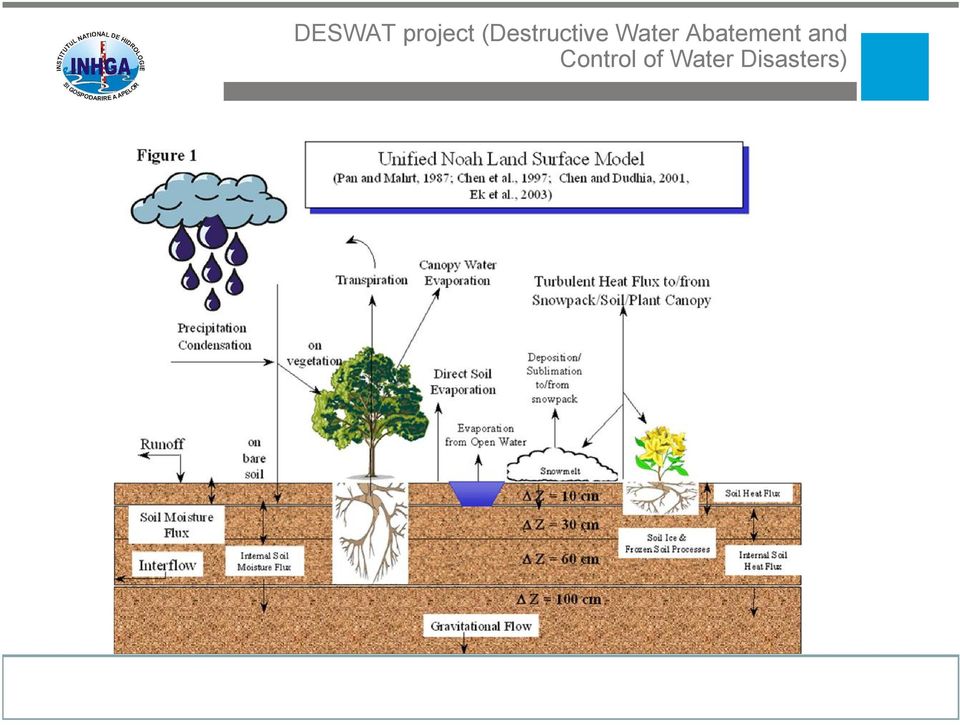
6 The second component is the distributed modeling component, which is mainly based on the NOAH-R model, model that contains five primary interacting physical process sub-models, with a land surface model (LSM) which runs at the radar-scale (1km), and overland and channel routing model, nested within the LSM, at 100m resolution. FLOOD MANAGEMENT WORKSHOP

7 FLOOD MANAGEMENT WORKSHOP

8 FLOOD MANAGEMENT WORKSHOP

9 FLOOD MANAGEMENT WORKSHOP
10 FLOOD MANAGEMENT WORKSHOP

11 The system also includes a Flash-Flood Guidance component, in which soil-moisture deficits are estimated in a continuous way, using a conceptual hydrological model for every small basin (with a mean area of km2). The deficits are used together with up-todate (1hr, 3hr and 6hr) precipitation totals to estimate the amount of additional precipitation needed for streams to reach bankfull conditions. FLOOD MANAGEMENT WORKSHOP

12 FLOOD MANAGEMENT WORKSHOP

13 FLOOD MANAGEMENT WORKSHOP

14 FLOOD MANAGEMENT WORKSHOP

15 Plan for the future For us, the implementation of the DESWAT Hydrological Modeling and Forecasting System is not an end, is in fact the foundation for a new start for a new evolution cycle of the Romanian National Hydrological Forecasting System, with the following main objectives: Improve the forecasters main control user interface to the modeling systems; Add multimodel and ensemble hydrological forecasts capabilities; Use 1D/2D hydraulic routing models in real-time; Improve the dissemination system; Continuous improvement of the calibration and/or configuration of the hydrological forecasting models in use; Develop special data assimilation procedures for the operational hydrological distributed models (NOAH) Dynamic flood mapping; FLOOD MANAGEMENT WORKSHOP
 Dynamic flood mapping; FLOOD MANAGEMENT")
16 Thank you very much for your attention!

HAZARD RISK ASSESSMENT, MONITORING, MAINTENANCE AND MANAGEMENT SYSTEM (HAMMS) FOR LANDSLIDE AND FLOOD. Mohd. Nor Desa, Rohayu and Lariyah, UNITEN
 FOR LANDSLIDE AND FLOOD. Mohd. Nor Desa, Rohayu and Lariyah, UNITEN") HAZARD RISK ASSESSMENT, MONITORING, MAINTENANCE AND MANAGEMENT SYSTEM (HAMMS) FOR LANDSLIDE AND FLOOD Mohd. Nor Desa, Rohayu and Lariyah, UNITEN WHAT WE HAVE IN MIND AND FROM OUR PREVIOUS PROJECT CONTRIBUTION
HAZARD RISK ASSESSMENT, MONITORING, MAINTENANCE AND MANAGEMENT SYSTEM (HAMMS) FOR LANDSLIDE AND FLOOD Mohd. Nor Desa, Rohayu and Lariyah, UNITEN WHAT WE HAVE IN MIND AND FROM OUR PREVIOUS PROJECT CONTRIBUTION
Eastern Caribbean Open-Source Geospatial Data Sharing and Management Workshop
 Eastern Caribbean Open-Source Geospatial Data Sharing and Management Workshop Data Collection and Management in the Caribbean Spice Island Resort, St. George s, Grenada October 6 7, 2011 Presented by:
Flash Flood Guidance Systems
 Flash Flood Guidance Systems Introduction The Flash Flood Guidance System (FFGS) was designed and developed by the Hydrologic Research Center a non-profit public benefit corporation located in of San Diego,
HYDROMETEOROLOGICAL AND MONITORING SERVICE
 Regional Association VI, Forum Hydrology, Koblenz May 8 10, 2012 MINISTRY OF EMERGENCY SITUATIONS OF ARMENIA ARMENIAN STATE HYDROMETEOROLOGICAL AND MONITORING SERVICE Amalya Misakyan THE STRUCTURE OF ARMSTATEHYDROMET
Armenian State Hydrometeorological and Monitoring Service
 Armenian State Hydrometeorological and Monitoring Service Offenbach 1 Armenia: IN BRIEF Armenia is located in Southern Caucasus region, bordering with Iran, Azerbaijan, Georgia and Turkey. The total territory
[ Climate Data Collection and Forecasting Element ] An Advanced Monitoring Network In Support of the FloodER Program
![[ Climate Data Collection and Forecasting Element ] An Advanced Monitoring Network In Support of the FloodER Program](/thumbs/33/16326315.jpg "[ Climate Data Collection and Forecasting Element ] An Advanced Monitoring Network In Support of the FloodER Program") [ Climate Data Collection and Forecasting Element ] An Advanced Monitoring Network In Support of the FloodER Program December 2010 1 Introduction Extreme precipitation and the resulting flooding events
[ Climate Data Collection and Forecasting Element ] An Advanced Monitoring Network In Support of the FloodER Program December 2010 1 Introduction Extreme precipitation and the resulting flooding events
Flood risk assessment through a detailed 1D/2D coupled model
 CORFU Project Barcelona Case Study Final Workshop 19 th of May 2014 Flood risk assessment through a detailed 1D/2D coupled model Beniamino Russo Aqualogy Urban Drainage Direction Introduction and general
National Weather Service Flash Flood Modeling and Warning Services
 National Weather Service Flash Flood Modeling and Warning Services Seann Reed, Middle Atlantic River Forecast Center Peter Ahnert, Middle Atlantic River Forecast Center August 23, 2012 USACE Flood Risk
Ensuring the Preparedness of Users: NOAA Satellites GOES R, JPSS Laura K. Furgione
 Ensuring the Preparedness of Users: NOAA Satellites GOES R, JPSS Laura K. Furgione U.S. Permanent Representative with the WMO Deputy Director, NOAA s s National Weather Service WMO Executive Council 65
Precipitation Monitoring Network:
 The Caribbean Drought and Precipitation Monitoring Network: Adrian R. Trotman Caribbean Institute for Meteorology and Hydrology CARIWIN Regional Seminar 14-15 January, 2010 Georgetown, Guyana Why Plan
CURRENT STATUS OF HYDROLOGICAL DATA MANAGEMENT SYSTEM IN SLOVENIA. Country report. Dr. Mira Kobold
 CURRENT STATUS OF HYDROLOGICAL DATA MANAGEMENT SYSTEM IN SLOVENIA Country report Dr. Mira Kobold Slovenian Environment Agency REPUBLIC OF SLOVENIA SURFACE WATERS NETWORK 186 operating measuring stations
JASPERS Networking Platform
 JASPERS Networking Platform Promoting climate change adaptation, risk prevention and management in the Water Sector UK Emergency Warning System Rachel Brisley, Technical Director & Sophie Dusting, Analyst
The Caribbean Drought and Precipitation Monitoring Network: The Concept and its Progress
 The Caribbean Drought and Precipitation Monitoring Network: The Concept and its Progress Adrian R. Trotman Caribbean Institute for Meteorology and Hydrology Inter-regional Workshop on Indices and Early
Titelmasterformat durch Klicken. bearbeiten
 Evaluation of a Fully Coupled Atmospheric Hydrological Modeling System for the Sissili Watershed in the West African Sudanian Savannah Titelmasterformat durch Klicken June, 11, 2014 1 st European Fully
EFAS European Flood Awareness System
 EFAS European Flood Awareness System http://www.efas.eu/ EFAS Partner Network The first operational hydrological network in Europe Cristina Alionte Eklund Coordinator EFAS Dissemination Center History
Data Integration and long-term planning of the Observing Systems as a cross-cutting process in a NMS
 Data Integration and long-term planning of the Observing Systems as a cross-cutting process in a NMS ECAC Zurich, Setpember 15 2020 Ch. Häberli Deputy Head Climate Division/Head Meteorological Data Coordination
AZ EGER-PATAK HIDROLÓGIAI VIZSGÁLATA, A FELSZÍNI VÍZKÉSZLETEK VÁRHATÓ VÁLTOZÁSÁBÓL ADÓDÓ MÓDOSULÁSOK AZ ÉGHAJLATVÁLTOZÁS HATÁSÁRA
 AZ EGER-PATAK HIDROLÓGIAI VIZSGÁLATA, A FELSZÍNI VÍZKÉSZLETEK VÁRHATÓ VÁLTOZÁSÁBÓL ADÓDÓ MÓDOSULÁSOK AZ ÉGHAJLATVÁLTOZÁS HATÁSÁRA GÁBOR KEVE 1, GÉZA HAJNAL 2, KATALIN BENE 3, PÉTER TORMA 4 EXTRAPOLATING
National Dam Safety Program Technical Seminar #22. When is Flood Inundation Mapping Not Applicable for Forecasting
 National Dam Safety Program Technical Seminar #22 Thursday February 19 th 2015 Emmittsburg, MD When is Flood Inundation Mapping Not Applicable for Forecasting Victor Hom Hydrologic Services Division National
Decision support for urban drainage using radar data of HydroNET-SCOUT
 Weather Radar and Hydrology (Proceedings of a symposium held in Exeter, UK, April 2011) (IAHS Publ. 351, 2011). 1 Decision support for urban drainage using radar data of HydroNET-SCOUT ARNOLD LOBBRECHT
Science Infusion, RTO Transition & Phase-2 Planning
 Science Infusion, RTO Transition & Phase-2 Planning D.-J. Seo and Yuqiong Liu Hydrologic Ensemble Prediction Group (HEP) Hydrologic Science and Modeling Branch Hydrology Laboratory Office of Hydrologic
WELCOMES ALL THE ATTENDEES WATER UTILISATION, MEASUREMENT AND METHODOLOGIES
 SUTRON india WELCOMES ALL THE ATTENDEES WATER UTILISATION, MEASUREMENT AND ABOUT SUTRON USA Strong Corporation was founded in 1975 Sutron Operates in : Hydrological Meteorological Oceanic Aviation Real-Time
Water Management in Cuba: Problems, Perspectives, Challenges and the Role of the Cuban Academy of Sciences
 Water Management in Cuba: Problems, Perspectives, Challenges and the Role of the Cuban Academy of Sciences Daniela M. Arellano Acosta Environment Agency/ Water Commission, Academy of Science, CUBA Water
THE GEORGIA AUTOMATED ENVIRONMENTAL MONITORING NETWORK: TEN YEARS OF WEATHER INFORMATION FOR WATER RESOURCES MANAGEMENT
 THE GEORGIA AUTOMATED ENVIRONMENTAL MONITORING NETWORK: TEN YEARS OF WEATHER INFORMATION FOR WATER RESOURCES MANAGEMENT Gerrit Hoogenboom, D.D. Coker, J.M. Edenfield, D.M. Evans and C. Fang AUTHORS: Department
Climate vulnerability assessment Risks from urban flooding Interactive science and policy assessment
 Climate vulnerability assessment Risks from urban flooding Interactive science and policy assessment Flood risk from extreme precipitation in Copenhagen - Modelling results Per Skougaard Kaspersen, DTU
WATER QUALITY MONITORING AND APPLICATION OF HYDROLOGICAL MODELING TOOLS AT A WASTEWATER IRRIGATION SITE IN NAM DINH, VIETNAM
 WATER QUALITY MONITORING AND APPLICATION OF HYDROLOGICAL MODELING TOOLS AT A WASTEWATER IRRIGATION SITE IN NAM DINH, VIETNAM LeifBasherg (1) OlujZejlllJul Jessen (1) INTRODUCTION The current paper is the
Emergency Management Service. early warning FLOOD AND FIRE ALERTS. Space
 Emergency Management Service early warning FLOOD AND FIRE ALERTS Space 1 Copernicus at a Glance Copernicus is the European Union s Earth Observation programme: a user-driven space programme under civil
03 STRATEGIC REVIEW OF OPTIONS FOR FLOOD FORECASTING AND WARNING IN IRELAND
 03 STRATEGIC REVIEW OF OPTIONS FOR FLOOD FORECASTING AND WARNING IN IRELAND Jeremy 1, Sarah Conroy 1, Brian Golding 2, 1. JBA Consulting, Limerick 2. UK Meteorological Office Abstract JBA Consulting and
Real-time Monitoring Platform to Improve the Drinking Water Network Efficiency
 Real-time Monitoring Platform to Improve the Drinking Water Network Efficiency SUMMARY Recent advances in real-time water sensing technology have enabled new opportunities for improved assessment and management
1. Feedback on Decision Making (write down or email to [email protected])
") Discussion: Feedback, Validation, Future Activities 1. Feedback on Decision Making How might the system be useful to you (decision-making, planning, )? How would it interface with existing methods? What
Discussion: Feedback, Validation, Future Activities 1. Feedback on Decision Making How might the system be useful to you (decision-making, planning, )? How would it interface with existing methods? What
Flash Flood Science. Chapter 2. What Is in This Chapter? Flash Flood Processes
 Chapter 2 Flash Flood Science A flash flood is generally defined as a rapid onset flood of short duration with a relatively high peak discharge (World Meteorological Organization). The American Meteorological
Baudouin Raoult, Iryna Rozum, Dick Dee
 ECMWF contribution to the EU funded CHARME Project: A Significant Event Viewer tool Matthew Manoussakis Baudouin Raoult, Iryna Rozum, Dick Dee 5th Workshop on the use of GIS/OGC standards in meteorology
INSTALLATION OF AN AUTOMATED EARLY WARNING SYSTEM FOR ANNOTTO BAY
 TERMS OF REFERENCE INSTALLATION OF AN AUTOMATED EARLY WARNING SYSTEM FOR ANNOTTO BAY A Community Disaster Risk Reduction Project funded through the Building Disaster Resilient Communities Project (ODPEM)
Standardized Runoff Index (SRI)
") Standardized Runoff Index (SRI) Adolfo Mérida Abril Javier Gras Treviño Contents 1. About the SRI SRI in the world Methodology 2. Comments made in Athens on SRI factsheet 3. Last modifications of the factsheet
Standardized Runoff Index (SRI) Adolfo Mérida Abril Javier Gras Treviño Contents 1. About the SRI SRI in the world Methodology 2. Comments made in Athens on SRI factsheet 3. Last modifications of the factsheet
Hong Kong Observatory Summer Placement Programme 2015
 Annex I Hong Kong Observatory Summer Placement Programme 2015 Training Programme : An Observatory mentor with relevant expertise will supervise the students. Training Period : 8 weeks, starting from 8
FLOODALERT: A SIMPLIFIED RADAR-BASED EWS FOR URBAN FLOOD WARNING
 11 th International Conference on Hydroinformatics HIC 2014, New York City, USA FLOODALERT: A SIMPLIFIED RADAR-BASED EWS FOR URBAN FLOOD WARNING XAVIER LLORT (1), RAFAEL SÁNCHEZ-DIEZMA (1), ÁLVARO RODRÍGUEZ
REAL-TIME PREDICTION FOR FLOOD WARNING AND MANAGEMENT
 U.S.- Italy Research Workshop on the Hydrometeorology, Impacts, and Management of Extreme Floods Perugia (Italy), November 1995 REAL-TIME PREDICTION FOR FLOOD WARNING AND MANAGEMENT K. P. Georgakakos Hydrologic
Wireless Soil Moisture and Weather Monitoring System Caipos
 Wireless Soil Moisture and Weather Monitoring System Caipos System Overview Soil moisture and weather monitoring systems Caipos System Overview Caipos consists of base station, sensors and web application.
End to End Multi Hazard Early Warning Systems By Curt Barrett Hydrometeorological Consultant
 End to End Multi Hazard Early Warning Systems By Curt Barrett Hydrometeorological Consultant Disaster Risk Management- East Asia and Pacific Experts Roundtable on Urban Flood Risk Management March 17,
Dirk Nyland - Chief Engineer BC Ministry of Transportation and Infrastructure NRCan - CCIAD Presentation 9 September 2014
 Considerations for Addressing Climate Change Adaptation for Transportation Infrastructure in Highway Management, Design, Operation and Maintenance in British Columbia Dirk Nyland - Chief Engineer BC Ministry
MONITORING IRRIGATION SEASON - A SUPPORT TOOL FOR WATER MANAGEMENT AND SHORT-TERM ACTIONS
 OECD WORKSHOP ON IMPROVING THE INFORMATION BASE TO BETTER GUIDE WATER RESOURCE DECISION-MAKING 4-7 May, 2010, Zaragoza MONITORING IRRIGATION SEASON - A SUPPORT TOOL FOR WATER MANAGEMENT AND SHORT-TERM
Hydrologic Engineering Techniques for Regional Water Resources Planning
 US Army Corps of Engineers Hydrologic Engineering Center Hydrologic Engineering Techniques for Regional Water Resources Planning October 1969 Approved for Public Release. Distribution Unlimited. TP-17
Methods for Determination of Safe Yield and Compensation Water from Storage Reservoirs
 US Army Corps of Engineers Hydrologic Engineering Center Methods for Determination of Safe Yield and Compensation Water from Storage Reservoirs October 1966 Approved for Public Release. Distribution Unlimited.
New challenges of water resources management: Title the future role of CHy
 New challenges of water resources management: Title the future role of CHy by Bruce Stewart* Karl Hofius in his article in this issue of the Bulletin entitled Evolving role of WMO in hydrology and water
06 - NATIONAL PLUVIAL FLOOD MAPPING FOR ALL IRELAND THE MODELLING APPROACH
 06 - NATIONAL PLUVIAL FLOOD MAPPING FOR ALL IRELAND THE MODELLING APPROACH Richard Kellagher 1, Mike Panzeri 1, Julien L Homme 1, Yannick Cesses 1, Ben Gouldby 1 John Martin 2, Oliver Nicholson 2, Mark
Update on EUMETSAT ocean colour services. Ewa J. Kwiatkowska
 Update on EUMETSAT ocean colour services Ewa J. Kwiatkowska 1 st International Ocean Colour Science meeting, 6 8 May, 2013 EUMETSAT space data provider for operational oceanography Operational data provider
Ginger Paige and Nancy Mesner University of Wyoming Utah State University
 Effective Water Quality BMP Monitoring Tools Ginger Paige and Nancy Mesner University of Wyoming Utah State University Overview BMP Monitoring Guidance Document for Stream Systems Lessons learned CEAP
Environmental Data Services for Delaware:
 Environmental Data Services for Delaware: Serving Emergency Responders, Planners, and Researchers Network Delaware Day November 6, 2013 Overview Operational Data Services More than just research DEOS and
Transboundary cooperation in the flood forecasting and warning service within the international Morava river basin
 Transboundary cooperation in the flood forecasting and warning service within the international Morava river basin Eva Soukalová Český hydrometeorologický ústav, pobočka Brno [email protected] Morava
Environmental Data Management Programs
 Hydrologic Engineering Centre (HEC) Software CD Collection of programs, developed by the U.S. Army Corps of Engineers Environmental Data Management Programs Name: HEC-DSS Package Purpose: Data Storage
CRS 610 Ventura County Flood Warning System Website
 CRS 610 Ventura County Flood Warning System Website Purpose This document gives instructions and a description of the information available via the Ventura County Watershed Protection District s (VCWPD)
Real-time Ocean Forecasting Needs at NCEP National Weather Service
 Real-time Ocean Forecasting Needs at NCEP National Weather Service D.B. Rao NCEP Environmental Modeling Center December, 2005 HYCOM Annual Meeting, Miami, FL COMMERCE ENVIRONMENT STATE/LOCAL PLANNING HEALTH
National Disaster Management Institute
 National Disaster Management Institute CONTENTS one Cause of Urban Flood Disaster two Urban Flood Damage Case three Disaster Prevention Measures for Future Urban Flood four NDMI s Measures & Strategy for
River Flooding and the Grid-to-Grid Hydrological Model
 River Flooding and the Grid-to-Grid Hydrological Model Summary of Impacts Impact Mitigating the annual costs of damage from ordinary river flooding Mitigating the costs of damage from extreme river flooding
ANALYSIS OF THUNDERSTORM CLIMATOLOGY AND CONVECTIVE SYSTEMS, PERIODS WITH LARGE PRECIPITATION IN HUNGARY. Theses of the PhD dissertation
 ANALYSIS OF THUNDERSTORM CLIMATOLOGY AND CONVECTIVE SYSTEMS, PERIODS WITH LARGE PRECIPITATION IN HUNGARY Theses of the PhD dissertation ANDRÁS TAMÁS SERES EÖTVÖS LORÁND UNIVERSITY FACULTY OF SCIENCE PhD
GRDC. Global Runoff Data Centre. Facilitator between Runoff Data Providers and Data Users
 GRDC Global Runoff Data Centre Facilitator between Runoff Data Providers and Data Users Second UN-SPIDER Workshop Disaster Management and Space Technology Bridging the Gap 13 15 October 2008 Bonn, Germany
Hydrology & Hydraulics
 Hydrology & Hydraulics ADAPTING TO NEW WEATHER REALITIES Presentation to Technical Committee of Lake Ontario Integrated Sub watershed Study March 24, 2014 Neelam Gupta Manager, Hydrology & Hydraulics Credit
Environment Canada's Water Quality Monitoring Programs and the National Automated Monitoring Network
 Environment Canada's Water Quality Monitoring Programs and the National Automated Monitoring Network The National Automated Water Quality Monitoring Team Water Quality Monitoring and Surveillance Division
Drought Monitoring and Forecasting in Sub-Saharan African. Justin Sheffield Princeton University
 Drought Monitoring and Forecasting in Sub-Saharan African Justin Sheffield Princeton University Outline Challenges for sub-saharan Africa (SSA) Current capabilities (national, regional, international) Princeton
Ubiquitous Wireless Sensor Networks for Environmental and Climate Data Management System
 Ubiquitous Wireless Sensor Networks for Environmental and Climate Data Management System Presenter: M.Eng Vo Minh Thanh School of Electrical Engineering International University HCM National University
Phare project: Development of the National Hydrometric network to EU standards Estonia. Olga Kovalenko Hydrology Department EMHI
 ESTONIN METEOROLOGICL ND HYDROLOGICL INSTITUTE Phare project: Development of the National Hydrometric network to EU standards Estonia Olga Kovalenko Hydrology Department EMHI im of the project Estonia
Catchment Scale Processes and River Restoration. Dr Jenny Mant [email protected]. The River Restoration Centre therrc.co.uk
 Catchment Scale Processes and River Restoration Dr Jenny Mant [email protected] The River Restoration Centre therrc.co.uk 3 Main Catchment Elements Hydrology Energy associated with the flow of water affects
THE STRATEGIC PLAN OF THE HYDROMETEOROLOGICAL PREDICTION CENTER
 THE STRATEGIC PLAN OF THE HYDROMETEOROLOGICAL PREDICTION CENTER FISCAL YEARS 2012 2016 INTRODUCTION Over the next ten years, the National Weather Service (NWS) of the National Oceanic and Atmospheric Administration
An Example of Flood Forecasting and Decision- Support System for Water Management in Spain
 An Example of Flood Forecasting and Decision- Support System for Water Management in Spain Alicia Cabañas Ibañez KV Consultores Madrid, Spain [email protected] Luis Garrote de Marcos Universidad
ALERT and IFLOWS System Descriptions
 Appendix C ALERT and IFLOWS System Descriptions Automated Local Evaluation in Real Time (ALERT) The ALERT system was initially developed in the 1970s by the California-Nevada River Forecast Center in Sacramento,
Guideline: Works that interfere with water in a watercourse watercourse diversions. September 2014
 Guideline: Works that interfere with water in a watercourse watercourse diversions September 2014 This publication has been compiled by the Department of Natural Resources and Mines. State of Queensland,
Elbe flood in 2002 and 2006 in terms of emergency management
 Elbe flood in 2002 and 2006 in terms of emergency management Ing. Jaroslav Pikal, Regional Authority of the Usti Region 10 Years of Transnational Cooperation in Flood Risk Management at the LABe ELbe Saxon
Global Flood Alert System (GFAS)
") An Introduction of Global Flood Alert System (GFAS) Kazuo UMEDA Director of 2 nd Research Department, Infrastructure Development Institute-JAPAN Target: Reduction of Human Loss World s s natural disaster
An Introduction of Global Flood Alert System (GFAS) Kazuo UMEDA Director of 2 nd Research Department, Infrastructure Development Institute-JAPAN Target: Reduction of Human Loss World s s natural disaster
Solar Performance Mapping and Operational Yield Forecasting
 Solar Performance Mapping and Operational Yield Forecasting Supported by Innovate UK Crown copyright Met Office The thing is that Project Overview A collaborative project led by the BRE National Solar
Nowcasting: analysis and up to 6 hours forecast
 Nowcasting: analysis and up to 6 hours forecast Very high resoultion in time and space Better than NWP Rapid update Application oriented NWP problems for 0 6 forecast: Incomplete physics Resolution space
NOAA Big Data Project. David Michaud Acting Director, Office of Central Processing Office Monday, August 3, 2015
 NOAA Big Data Project David Michaud Acting Director, Office of Central Processing Office Monday, August 3, 2015 Central Processing Portfolio Benefits and Scope Central Processing Portfolio Benefits Ensures
NWS Flood Inundation Mapping Program
 NWS Flood Inundation Mapping Program Carson River Floodplain Management Forum April 22, 2015 Mark Faucette, Senior Forecaster Hydrology Program Manager NOAA/NWS, WFO Reno, NV NWS Hydrologic Services Program
Penn State Cooperative Extension
 Penn State Cooperative Extension Marcellus Shale Educational Webinar Series April 2010 - September 2010 Penn State Cooperative Extension Marcellus Shale Educational Webinars April 2010 September 2010 Six-part
THE ESTABLISHMENT OF A HELPDESK FOR INTEGRATED FLOOD MANAGEMENT
 FRAMEWORK DOCUMENT FOR THE ESTABLISHMENT OF A HELPDESK FOR INTEGRATED FLOOD MANAGEMENT This document sets out the basic objectives, structure and roles of the HelpDesk for Integrated Flood Management.
2D Modeling of Urban Flood Vulnerable Areas
 2D Modeling of Urban Flood Vulnerable Areas Sameer Dhalla, P.Eng. Dilnesaw Chekol, Ph.D. A.D. Latornell Conservation Symposium November 22, 2013 Outline 1. Toronto and Region 2. Evolution of Flood Management
Monitoring at Credit Valley Conservation. Presented by Jackie Thomas and Luke Harvey
 Monitoring at Credit Valley Conservation Presented by Jackie Thomas and Luke Harvey Where are we? WHAT IS MONITORING? Long-term sampling of the same point or reach to track changes over time/space Short
Catastrophe Bond Risk Modelling
 Catastrophe Bond Risk Modelling Dr. Paul Rockett Manager, Risk Markets 6 th December 2007 Bringing Science to the Art of Underwriting Agenda Natural Catastrophe Modelling Index Linked Securities Parametric
Monitoring data and existing information Country Presentation from Turkey
 Workshop on DEVELOPING REGIONAL COOPERATION FOR SHARED KARST AQUIFER MANAGEMENT IN SEE 27-28 June 2008 Thessaloniki, Greece Monitoring data and existing information Country Presentation from Turkey Plan
DEWETRA: la piattaforma nazionale per la condivisioni di dati, previsioni e procedure per le attivita di DRR
 Dipartimento della Protezione Civile Fondazione CIMA DEWETRA: la piattaforma nazionale per la condivisioni di dati, previsioni e procedure per le attivita di DRR G. Boni 2, P. Pagliara 1, A. Corina 1 1
Flood mitigation program for Gatun lake. Programa de mitigación de inundaciones del lago Gatún
 Flood mitigation program for Gatun lake Programa de mitigación de inundaciones del lago Gatún Moffatt & Nichol Engineers 10 de febrero de 2005 Contrato No. 126161 Introducción y Recomendaciones 1 INTRODUCTION