Breakout Session Large stocks, larger uncertainties: The role of soils in North American carbon cycle
|
|
|
- Gervais Simmons
- 8 years ago
- Views:
Transcription
1 Breakout Session Large stocks, larger uncertainties: The role of soils in North American carbon cycle Network of Intensive Carbon Monitoring Sites in Mexico: Challenges for soil organic carbon estimation and modeling Gregorio Ángeles-Pérez, Vanessa Maldonado-Montero, Kristofer Johnson David López-Merlín, Marcela Olguín-Álvarez, Craig-Wayson, Richard Birdsey Washington, DC. January 28th, 2015

2 CICY José Luis Andrade José Luis Hernández Juan Manuel Dupuy COLPOS Gregorio Ángeles René Valdez Héctor de los Santos ECOSUR Ligia Esparza PMN-CONAFOR Benjamín Méndez David López Gonzalo Sánchez Jorge Morfín Juan Pablo Caamal Marcela Olguín Oswaldo Carrillo Vanessa Maldonado University of British Columbia Nicholas Coops Vanessa Silva Canadian Forest Service David Greenberg Max Fellows Scott Morken Werner Kurz CEC Karen Richardson US Forest Service-SilvaCarbon Craig Wayson Kristofer Johnson Richard Birdsey Zhaohua Dai Local organizations Ejidos Atopixco-La Mojonera, Hidalgo Ejido Dos Lagunas Norte, Campeche Ejido Felipe Carrillo Puerto, Quintana Roo Reserva Biocultural Kaxil Kiuc, Yucatán Mexico-Goverment organizations Comisión Nacional Forestal (CONAFOR) Comisión Nacional de Áreas Protegidas (CONANP) Comisión Nacional para el Conocimiento y Uso de la Biodiversidad (CONABIO)
 Comisión Nacional de")
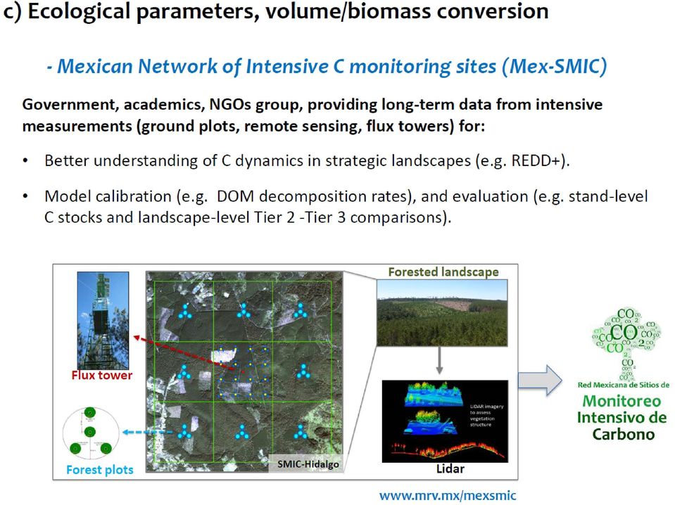
3 Network of Intensive Monitoring Sites Red Mex-SMIC

4 Network of Intensive Carbon Monitoring Sites Red Mex-SMIC What is a SMIC? Site to intensive monitoring forest C stocks and C stock changes, from the integreation muti-scale measurements: Ground plots Eddy covariance towers Remote sensing (diff. Spatial and temporal resolutions, e.g. LiDAR, Landsat, Rapid eye, etc.) C dynamics models (empirical, process) From Birdsey et al. 2010

5 Idealized Sampling Scheme for a Landscape-scale Intensive Monitoring Site 3 km Landscape monitoring sample location Validation sample location Flux tower Nearby national forest inventory plot (location hidden) 3 x 3 km grid of inventory plots surrounding a meteorological tower or other installation at center Inventory plots follow standard FIA protocol Other measures (litterfall, respiration) take place at inventory plots Larger area for remote sensing; will include range of disturbance
 take place at inventory plots Larger area for remote sensing; will include range")
6 National FI and Intensive Sites

7 Network of Intensive Carbon Monitoring Sites *Mex-SMIC* Atopixco (Hidalgo) Kaxil Kiuic (Yucatán) Álamos (Sonora) Calakmul (Campeche) Uyoolche (Quintana Roo) Selection criteria: a) Landscapes with great contribution to net carbon balance ( LULUC forest sector) b) Priority area for REDD+ activities c) Potential multi-institutional collaboration to collect and access data in the long term La Encrucijada (Chiapas)

8
9 Álamos, Sonora Atopixco, Hidalgo Kaxil Kiuc, Yucatán

10 Variables Litter Soil depth: total, real Pit Volume Rocks Roots Litter: Depth Weight %C Roots: Weight %C Soils: ph Texture Water holding capacity %C %N

11 Quantitative Method Pennino et al Vadeboncoeur et al. 2012

12 Procedimiento Plot layout para el - SMIC material leñoso caído (MLC) en los SMI CWD sampling Litter and Soil sampling Soil depth Understory vegetation Fuente: PMN, 2013

13 Procedimiento para-elsmic material leñoso caído (MLC) Soil samplig en los SMI Atopixco Litter and Soil sampling Kaxil Kiuc Soil depth Felipe CP

14 Preliminary Calculations: Bulk Density and Rocks Variability within depth increments indicates importance of accurate measurements of bulk density and rocks in rocky dry forest ecosystems. General patterns with depth indicate differences between sites. See Johnson et al poster, #112

15 Preliminary Calculations: Soil Depth LIDAR elevation data (background images) can be used with field data to develop high resolution maps of important soil properties. Felipe Carrillo Larger dots = Deeper Soils Atopixco Kiuic See Johnson et al poster, #112

16 NA Depth cm cm Soil Carbon 0-15 cm Carbono (Mg/ha) Stand age (years) Depth Ángeles et al. in prep.
 Depth Ángeles et al.")
17 Forest Floor Mass Atopixco

18 Final remarks The intensive sampling methods presented uniquely represent landscape scale soil properties that are important to ecosystem functions. Soil chemical and physical data support the calibration and validation of process models for scaling to larger regions (e.g. CBM-CFS3, Forest-DNDC, Century, RothC, Yasso, InteC). Additional belowground data is being collected: litterfall production, litter and branch decomposition rates, soil respiration, belowground biomass, and fine root dynamics.
.")
19 Acknowledgments Atopixco, Hidalgo Calakmul, Campeche

Testing steady states carbon stocks of Yasso07 and ROMUL models against soil inventory data in Finland
 Testing steady states carbon stocks of Yasso07 and ROMUL models against soil inventory data in Finland A. Lehtonen 1, T. Linkosalo 2, J. Heikkinen 1, M. Peltoniemi 1, R. Sievänen 1, R. Mäkipää 1, P. Tamminen
Environmental impacts of harvesting biomass from the Nordic forests. Nicholas Clarke Norwegian Forest and Landscape Institute
 1 Environmental impacts of harvesting biomass from the Nordic forests Nicholas Clarke Norwegian Forest and Landscape Institute Background 2 Increased use of forest biomass for energy might lead to conflict
Data Management Framework for the North American Carbon Program
 Data Management Framework for the North American Carbon Program Bob Cook, Peter Thornton, and the Steering Committee Image courtesy of NASA/GSFC NACP Data Management Planning Workshop New Orleans, LA January
Productivity in Cloud Forests in the Andes
 Productivity in Cloud Forests in the Andes Carbon cycle measurements and model results from JULES Toby Marthews http://marthews.tripod.com Leeds, 10th June 2010 at the Oxford University Centre for the
National and Sub-national Carbon monitoring tools developed at the WHRC
 National and Sub-national Carbon monitoring tools developed at the WHRC Nadine Laporte Woods Hole Research Center A. Baccini, W. Walker, S. Goetz, M. Sun, J. Kellndorfer Kigali, 20 th June 2011 Why measuring
Uncertainty assessment of forest carbon balance. HMS seminaari 2.9 Vantaa
 Uncertainty assessment of forest carbon balance Research Team Finnish Forest Research Institute Raisa Mäkipää, Mikko Peltoniemi, Aleksi Lehtonen European Forest Institute (EFI) Taru Palosuo, Terhi Kaipainen
GEOGG142 GMES Calibration & validation of EO products
 GEOGG142 GMES Calibration & validation of EO products Dr. Mat Disney mdisney@geog.ucl.ac.uk Pearson Building room 113 020 7679 0592 www.geog.ucl.ac.uk/~mdisney Outline Calibration & validation Example:
Multi-taxa surveys: integrating ecosystem processes and user demands
 Multi-taxa surveys: integrating ecosystem processes and user demands William E. Magnusson PPBio Amazônia ocidental Instituto Nacional de Pesquisas da Amazônia (INPA) PPBio overview The PPBio is a program
Landscape Carbon Monitoring and Analysis at the Experimental Forest Network
 Landscape Carbon Monitoring and Analysis at the Experimental Forest Network Richard Birdsey USDA Forest Service 11 Campus Blvd Suite 200 Newtown Square, PA 19073 rbirdsey@fs.fed.us Randall Kolka, Marie-Louise
NRI Soil Monitoring Network
 NRI Soil Monitoring Network Stephen Ogle, Keith Paustian, Karolien Denef, Ram Gurung, F. Jay Breidt Colorado State University Mike Sucik and Daryl Lund USDA Natural Resources Conservation Service Goals
How To Predict Soil Carbon Stock
 CASO DE ESTUDIO SOBRE PREDICCION DE PROPIEDADES DE SUELOS A TRAVÉS DE PUNTOS: El Carbono Organico en los Suelos de Rio de Janeiro, Brasil M.L. Mendonça Santos, Dart, R., Rizzato, M. Embrapa Solos Objectivos
Supporting Online Material for
 Originally published 14 July 2011; corrected 11 August 2011 www.sciencemag.org/cgi/content/full/science.1201609/dc1 Supporting Online Material for A Large and Persistent Carbon Sink in the World s Forests
Australia s National Carbon Accounting System. Dr Gary Richards Director and Principal Scientist
 Australia s National Carbon Accounting System Dr Gary Richards Director and Principal Scientist Government Commitment The Australian Government has committed to a 10 year, 3 phase, ~$35M program for a
Life Cycle Of A Plant Population
 Life Cycle Of A Plant Population Seed Rain n=3 Growth And Mortality n=7 Seedling Cohort n=22 Environmental Sieve Seed Bank n=5 Copyright G. Bonan 22 Suvivorship Of Seedlings In A Northern Hardwood Forest
THE DETAILS OF REAL-TIME REPORT CARDING THROUGH LOUISIANA S COASTWIDE REFERENCE MONITORING SYSTEM
 THE DETAILS OF REAL-TIME REPORT CARDING THROUGH LOUISIANA S COASTWIDE REFERENCE MONITORING SYSTEM Sarai Piazza, Marc Comeaux, Craig Conzelmann, & Dona Weifenbach CEER July 30, 2014 CRMS - Coastal Wetlands
Report of the technical assessment of the proposed forest reference emission level of Brazil submitted in 2014
 United Nations FCCC/TAR/2014/BRA Distr.: General 1 December 2014 English only Report of the technical assessment of the proposed forest reference emission level of Brazil submitted in 2014 Summary This
Integrated Global Carbon Observations. Beverly Law Prof. Global Change Forest Science Science Chair, AmeriFlux Network Oregon State University
 Integrated Global Carbon Observations Beverly Law Prof. Global Change Forest Science Science Chair, AmeriFlux Network Oregon State University Total Anthropogenic Emissions 2008 Total Anthropogenic CO 2
Land Use/Land Cover Map of the Central Facility of ARM in the Southern Great Plains Site Using DOE s Multi-Spectral Thermal Imager Satellite Images
 Land Use/Land Cover Map of the Central Facility of ARM in the Southern Great Plains Site Using DOE s Multi-Spectral Thermal Imager Satellite Images S. E. Báez Cazull Pre-Service Teacher Program University
Data Management for the North American Carbon Program
 Image courtesy of NASA/GSFC Data Management for the North American Carbon Program Bob Cook, Eric Sundquist, Tom Boden,, and Peter Thornton RS in NACP Workshop Missoula, MT August 20, 2004 NACP Data and
MAPPING FOREST SOIL ORGANIC MATTER ON NEW JERSEY S COASTAL PLAIN
 MAPPING FOREST SOIL ORGANIC MATTER ON NEW JERSEY S COASTAL PLAIN Brian J. Clough, Edwin J. Green, and Richard G. Lathrop 1 Abstract. Managing forest soil organic matter (SOM) stocks is a vital strategy
Nature Values Screening Using Object-Based Image Analysis of Very High Resolution Remote Sensing Data
 Nature Values Screening Using Object-Based Image Analysis of Very High Resolution Remote Sensing Data Aleksi Räsänen*, Anssi Lensu, Markku Kuitunen Environmental Science and Technology Dept. of Biological
Environmental Risk Assessment for FSC certification in the Selva Maya (Maya Forest)
") Environmental Risk Assessment for FSC certification in the Selva Maya (Maya Forest) Revision for 31 May 2009 Timothy Synnott Matthew Wenban-Smith A project supported by ICCO, The Netherlands www.oneworldstandards.com/era.html
Environmental Risk Assessment for FSC certification in the Selva Maya (Maya Forest) Revision for 31 May 2009 Timothy Synnott Matthew Wenban-Smith A project supported by ICCO, The Netherlands www.oneworldstandards.com/era.html
CRMS Website Training March 2015
 CRMS Website Training March 2015 http://www.lacoast.gov/crms CWPPRA Restoration Program CWPPRA was congressionally funded in 1990 and mandated 20 years of restoration project monitoring CWPPRA program
Technical paper. Summary
 UNITED NATIONS Distr. GENERAL FCCC/TP/2009/1 31 May 2009 ENGLISH ONLY Cost of implementing methodologies and monitoring systems relating to estimates of emissions from deforestation and forest degradation,
Agroforestry and climate change. Emmanuel Torquebiau FAO webinar 5 February 2013
 Agroforestry and climate change Emmanuel Torquebiau FAO webinar 5 February 2013 Agroforestry: well-known buffering and resilience effects Climate variability is well buffered by agroforestry because of
Key Words Forest Ecosystem, Carbon Dynamics, Boreal Forests, Tropical Forests, Plots Network
 1 - i Global Environment Research Account for National Institutes Advancement of East Asia Forest Dynamics Plots Network -Monitoring forest carbon cycling for the development of climate change adaptation-(abstract
CRMS Website Training
 CRMS Website Training March 2013 http://www.lacoast.gov/crms Coastwide Reference Monitoring System - Wetlands CWPPRA Restoration Projects Congressionally funded in 1990 Multiple restoration techniques
Jeongho SEO, Kyeonghak LEE, Raehyun KIM Korea Forest Research Institute. 6~8. Sept. 2007 Kuala Lumpur, Malaysia
 5 th Workshop on GHG Inventory in Asia Jeongho SEO, Kyeonghak LEE, Raehyun KIM Korea Forest Research Institute 6~8. Sept. 2007 Kuala Lumpur, Malaysia Contents 1/ 32 Background 2/ 32 Land Use and Forestry
The National Inventory and Monitoring Application Center and Forest Plan Monitoring and Evaluation
 The National Inventory and Monitoring Application Center and Forest Plan Monitoring and Evaluation Chip Scott, Manager National Inventory and Monitoring Application Center Northern Research Station USDA
CARBON BALANCE IN BIOMASS OF MAIN FOREST TREE SPECIES IN POLAND
 CARBON BALANCE IN BIOMASS OF MAIN FOREST TREE SPECIES IN POLAND PAWEŁ STRZELIŃSKI Department of Forest Management Poznan University of Life Science TOMASZ ZAWIŁA-NIEDŹWIECKI Forest Research Institute in
Atmospheric- and ground-based studies indicate that the
 Projecting the future of the U.S. carbon sink G. C. Hurtt*, S. W. Pacala, P. R. Moorcroft, J. Caspersen, E. Shevliakova, R. A. Houghton, and B. Moore III* *Institute for the Study of Earth Oceans and Space,
Forest carbon sequestration and climate change. Dr Brian Tobin University College Dublin
 Forest carbon sequestration and climate change Dr Brian Tobin University College Dublin Overview Sequestration what is it & why important? Role of forests in climate change CARBiFOR research project Forest
Assessment of cork production in new Quercus suber plantations under future climate. Joana A Paulo Margarida Tomé João HN Palma
 Assessment of cork production in new Quercus suber plantations under future climate Joana A Paulo Margarida Tomé João HN Palma 22 May 2012 1 Introduction Climate is related to several variables that affect
Multi-scale upscaling approaches of soil properties from soil monitoring data
 local scale landscape scale forest stand/ site level (management unit) Multi-scale upscaling approaches of soil properties from soil monitoring data sampling plot level Motivation: The Need for Regionalization
Create Your Own Soil Profile Ac5vity
 Create Your Own Soil Profile Ac5vity Middle School: 5-8 Task Overview: Soil profile refers to layers of soil. A typical soil profile takes nearly 1,000 to 100,000 years to form. The formation of the soil
Urban Tree Planting Quantification Guidance
 Urban Tree Planting Quantification Guidance June 2014 This document provides guidance for quantifying an Urban Tree Planting (UTP) Project s carbon stocks, both for purposes of estimating a project s baseline
Resolutions of Remote Sensing
 Resolutions of Remote Sensing 1. Spatial (what area and how detailed) 2. Spectral (what colors bands) 3. Temporal (time of day/season/year) 4. Radiometric (color depth) Spatial Resolution describes how
International Integration Workshop on Sea-Level Rise, Merida, Yucatan, Oct. 21-23, 2013 Program
 Monday, October 21. City Express Merida, City 1 Meeting Room. 8:00-8:30 Registration and Breakfast (Provided in City 2 Meeting Room) 8:30-9:00 Inauguration Ceremony Romeo de Coss, Director, CINVESTAV Merida
MIGRATION FACTS. Variable Impacts: State-level Analysis of the Slowdown in the Growth of Remittances to Mexico
 The Migration Policy Institute is an independent, non-partisan, and non-profit think tank dedicated to the study of the movement of people worldwide. The institute provides analysis, development, and evaluation
EUROPARC-Spain and the Spanish system of Protected Areas
 EUROPARC-Spain and the Spanish system of Protected Areas Ideas in action in Spain: the Action Plan for Parks Idee in azione in Spagna: il piano di azione Dr. José V. De Lucio Director EUROPARC-Spain EUROPARC-Spain
A Streamlined Approach to the Component Ratio Method for RGGI U.S. Forest Projects Outside of California, Oregon, Washington, Alaska and Hawaii
 for RGGI U.S. Forest Projects Outside of California, Oregon, Washington, Alaska and Hawaii May 13, 2015 Background on the Component Ratio Method... 2 Streamlined Approach to the Component Ratio Method...
The San Juan Bay Estuary Program and its Initiatives toward a Climate Ready Estuary
 The San Juan Bay Estuary Program and its Initiatives toward a Climate Ready Estuary CACCE Conference-Workshop 2012 Dr. Jorge Bauza-Ortega Scientific Advisor San Juan Bay Estuary Program Today presentation
PROPOSED TERMS OF REFERENCE
 Annexure-IV PROPOSED TERMS OF REFERENCE 1.0 Proposed Scope of Work for EIA Study The components of the EIA study include: Detailed description of all elements of the project activities (existing and proposed
THE MANGROVE PROTECTION Vs. TURISM DEVELOPMENT
 THE MANGROVE PROTECTION Vs. TURISM DEVELOPMENT A mangrove is a tree and bush species group that possesses adaptation abilities, and that colonizes flooded lands that are impacted by saltwater intrusions.
Environmental Outcomes of Conservation Agriculture in North Italy
 Environmental Outcomes of Conservation Agriculture in North Italy Stefano Brenna ERSAF Regional Agency for Agriculture and Forests of Lombardy (Italy) 6th World Congress on Conservation Agriculture Winnipeg,
Three Continuing Years of Proven Success!
 Three Continuing Years of Proven Success! Thanks to your valuable participation, Mexico WindPower 2014 was a great success, consolidating its reputation as the most important wind power event in Mexico
Soil Properties soil texture and classes heat capacity, conductivity and thermal diffusivity moisture conductivity
 Lecture 33 Lecture on Soil Physics, part 1 Soil Properties soil texture and classes heat capacity, conductivity and thermal diffusivity moisture conductivity porosity and diffusion i Theory, Heat Transfer
Innovation and new land monitoring services for climate change, forests and agroforestry
 Innovation and new land monitoring services for climate change, forests and agroforestry Martin Herold Wageningen University Center for Geoinformation Current distribution of aboveground biomass Terrestrial
KATHRYN ANN SORENSEN Email: Kathryn.Sorensen@ashford.edu
 KATHRYN ANN SORENSEN Email: Kathryn.Sorensen@ashford.edu EDUCATION PhD., Anthropology, 2010. M.A., Anthropology, 2002. B.S., Anthropology, Cum Laude, 2000. RESEARCH INTERESTS Settlement patterns and landscape
Threats to tropical forests
 Threats to tropical forests and what we can do about it Ryszard Laskowski Institute of Environmental Sciences Jagiellonian University www.eko.uj.edu.pl/laskowski 1/22 Human activities: dangers and hopes
CAPACITY BUILDING FOR RECYCLING - BASED ECONOMY IN APEC MEXICO
 CAPACITY BUILDING FOR RECYCLING - BASED ECONOMY IN APEC PLANNING WORKSHOP MEXICO HAKONE, JAPAN AUGUST 30 SEPTEMBER 1 166 SOLID WASTE IN MEXICO 167 PALENQUE 168 MEXICO BAJA CALIFORNIA NORTE SONORA CHIHUAHUA
Predicted reduction of suitable climate habitat of Mexican conifers due to climatic change. Assisted migration as management option
 Predicted reduction of suitable climate habitat of Mexican conifers due to climatic change. Assisted migration as management option Cuauhtémoc Sáenz-Romero, Dante Castellanos-Acuña Instituto de Investigaciones
Supporting Online Material for Achard (RE 1070656) scheduled for 8/9/02 issue of Science
 scheduled for 8/9/02 issue of Science") Supporting Online Material for Achard (RE 1070656) scheduled for 8/9/02 issue of Science Materials and Methods Overview Forest cover change is calculated using a sample of 102 observations distributed
Supporting Online Material for Achard (RE 1070656) scheduled for 8/9/02 issue of Science Materials and Methods Overview Forest cover change is calculated using a sample of 102 observations distributed
INTERPRETATION ADDENDUM CANADIAN MINING COMPANY INC. SUITE 2300-1066 WEST HASTINGS STREET VANCOUVER, BC V6E 3X2 3D INDUCED POLARIZATION
 INTERPRETATION ADDENDUM FOR CANADIAN MINING COMPANY INC. SUITE 2300-1066 WEST HASTINGS STREET VANCOUVER, BC V6E 3X2 3D INDUCED POLARIZATION ON THE SAN BERNARDO PROJECT EL GOCHICO GRID Approximate Location:
International consortium on the forest investigation and innovation Permanent Research Plots Network for Peru
 International consortium on the forest investigation and innovation Permanent Research Plots Network for Peru 25 20 Guazuma crinita d 1.3 = 21.8 cm h = 22.9 m 1-15 Crown base Height, m 15 3/5H 10 1/2 Crown
GEOGRAPHICAL INFORMATION SYSTEM (GIS) AS A TOOL FOR CERTIFICATION OF BIOFUELS IN ARGENTINA
 AS A TOOL FOR CERTIFICATION OF BIOFUELS IN ARGENTINA") GEOGRAPHICAL INFORMATION SYSTEM (GIS) AS A TOOL FOR CERTIFICATION OF BIOFUELS IN ARGENTINA International Workshop CHALLENGES AND SOCIAL AND ENVIRONMENTAL IMPACTS OF THE BIOFUEL PRODUCTION IN AMERICA. Buenos
GEOGRAPHICAL INFORMATION SYSTEM (GIS) AS A TOOL FOR CERTIFICATION OF BIOFUELS IN ARGENTINA International Workshop CHALLENGES AND SOCIAL AND ENVIRONMENTAL IMPACTS OF THE BIOFUEL PRODUCTION IN AMERICA. Buenos
Sintermann discussion measurement of ammonia emission from field-applied manure
 Sintermann discussion measurement of ammonia emission from field-applied manure Jan Huijsmans, Julio Mosquera and Arjan Hensen 9 April 2013 During the1990 s the measurement methods for ammonia (NH 3 )
Science Rationale. Status of Deforestation Measurement. Main points for carbon. Measurement needs. Some Comments Dave Skole
 Science Rationale Status of Deforestation Measurement Some Comments Dave Skole Tropical deforestation is related to: Carbon cycle and biotic emissions/sequestration Ecosystems and biodiversity Water and
Climate Futures Evaluation and Synthesis Tool
 Climate Futures Evaluation and Synthesis Tool September 2015 Alexander Epstein, Ben Rasmussen, and Chris Cutler The National Transportation Systems Center Advancing transportation innovation for the public
Francisco Márquez 146 Colonia Condesa México D:F. C.P. 06140 Tel (55) 52 11 86 88 Fax (55) 52 56 04 47 www.metropoliarquitectos.
 52 11 86 88 Fax (55) 52 56 04 47 www.metropoliarquitectos.") Francisco Márquez 146 Colonia Condesa México D:F. C.P. 06140 Tel (55) 52 11 86 88 Fax (55) 52 56 04 47 www.metropoliarquitectos.com c.v. metropoli arquitectos METROPOLI ARQUITECTOS, S.C. is a developer
Francisco Márquez 146 Colonia Condesa México D:F. C.P. 06140 Tel (55) 52 11 86 88 Fax (55) 52 56 04 47 www.metropoliarquitectos.com c.v. metropoli arquitectos METROPOLI ARQUITECTOS, S.C. is a developer
Using Remote Sensing Imagery to Evaluate Post-Wildfire Damage in Southern California
 Graham Emde GEOG 3230 Advanced Remote Sensing February 22, 2013 Lab #1 Using Remote Sensing Imagery to Evaluate Post-Wildfire Damage in Southern California Introduction Wildfires are a common disturbance
Jennifer Andrea Chmilar, PhD
 , PhD CONTACT INFORMATION cell phone: (403) 560-4685 jachmilar@yahoo.ca or jchmilar@ucalgary.ca jenniferchmilar.wordpress.com EDUCATION PhD Anthropology, University of California, Riverside (June 2013)
Antamina Closure Plan: A Top Level Practice. Eng. Antonio Mendoza, M.Sc., MBA Environmental Manager 2010
 Antamina Closure Plan: A Top Level Practice Eng. Antonio Mendoza, M.Sc., MBA Environmental Manager 2010 Content Evolution of Environmental Regulation Closure Process Antamina Closure Evolution of Environmental
Potential Climate Impact of Large-Scale Deployment of Renewable Energy Technologies. Chien Wang (MIT)
") Potential Climate Impact of Large-Scale Deployment of Renewable Energy Technologies Chien Wang (MIT) 1. A large-scale installation of windmills Desired Energy Output: supply 10% of the estimated world
Potential Climate Impact of Large-Scale Deployment of Renewable Energy Technologies Chien Wang (MIT) 1. A large-scale installation of windmills Desired Energy Output: supply 10% of the estimated world
Module EN: Developing a Reference Level for Carbon Stock Enhancements
 USAID LEAF TECHNICAL GUIDANCE SERIES FOR THE DEVELOPMENT OF A FOREST CARBON MONITORING SYSTEM FOR REDD+ Module EN: Developing a Reference Level for Carbon Stock Enhancements USAID LEAF TECHNICAL GUIDANCE
Annual Funding Requested from the Joint Fire Science Program: $445,373 (year 1), $24,647 (year 2), $25,657 (year 3).
, $24,647 (year 2), $25,657 (year 3).") Project Title: Carbon cycling at the landscape scale: the effect of changes in climate and fire frequency on age distribution, stand structure, and net ecosystem production. Principal Investigator(s):
Project Title: Carbon cycling at the landscape scale: the effect of changes in climate and fire frequency on age distribution, stand structure, and net ecosystem production. Principal Investigator(s):
http://store.elsevier.com/forest-monitoring/ isbn-9780080982229/ Recommended citation for the full chapter:
 330 V Monitoring Methods for Atmosphere-Related Variables This is a publisher-agreed excerpt of a book chapter from a book published by Elsevier. The full content can be accessed via the following link:
Review of REDD+ implementation in Mexico
 Review of REDD+ implementation in Mexico ANALYSIS OF THE SPECIAL PROGRAMS IN REDD+ EARLY ACTION AREAS APRIL 2015 1 REVIEW OF REDD+ IMPLEMENTATION IN MEXICO Credits Review of REDD+ implementation in Mexico
Coastwide Reference Monitoring System Wetlands (CRMS-Wetlands) Project Update
 Project Update") Coastwide Reference Monitoring System Wetlands (CRMS-Wetlands) Project Update Louisiana Department of Natural Resources Coastal Restoration Division U.S. Geological Survey National Wetlands Research Center
Coastwide Reference Monitoring System Wetlands (CRMS-Wetlands) Project Update Louisiana Department of Natural Resources Coastal Restoration Division U.S. Geological Survey National Wetlands Research Center
III. THE MICROBIAL BIOMASS
 III. THE MICROBIAL BIOMASS Required Readings: Ley, R.E., D.A. Lipson and S.K. Schmidt. 2001. Microbial biomass levels in barren and vegetated high altitude talus soils. Soil Sci. Soc. Am. J. 65:111 117.
In this lesson, students will identify a local plant community and make a variety of
 MAKING COMMUNITY MEASUREMENTS: ABIOTIC FACTORS Grades 3 6 I. Introduction In this lesson, students will identify a local plant community and make a variety of measurements, preferably during two different
Let s SAR: Mapping and monitoring of land cover change with ALOS/ALOS-2 L-band data
 Let s SAR: Mapping and monitoring of land cover change with ALOS/ALOS-2 L-band data Rajesh Bahadur THAPA, Masanobu SHIMADA, Takeshi MOTOHKA, Manabu WATANABE and Shinichi rajesh.thapa@jaxa.jp; thaparb@gmail.com
Dominique Courault 1 et al
 Dominique Courault 1 et al 1 AVIGNON 2 Toulouse UMR TETIS Montpellier UMR Innovation CEEP réserve Crau Fondation Tour du Valat 1 1 SPOT4 on the mediterranean region biodiversity orchard A wide variety
Water Quality Modeling in Delaware s Inland Bays: Where Have We Been and Where Should We Go?
 Water Quality Modeling in Delaware s Inland Bays: Where Have We Been and Where Should We Go? Damian C. Brady University of Maine Center for the Inland Bays Science and Technical Advisory Committee March
4 GrowUp: A tool for computing forest Growth, nutrient Uptake and litterfall
 4 GrowUp: A tool for computing forest Growth, nutrient Uptake and litterfall L. Bonten, J.P. Mol-Dijkstra, R. Wiegger, G.J. Reinds Alterra (WUR), Wageningen, Netherlands Figure 4.1 gives an overview of
Diurnal and seasonal variations of CH 4 exchange observed in a black spruce forest
 Diurnal and seasonal variations of CH 4 exchange observed in a black spruce forest Hiroki Iwata (Kyoto Univ) Collaborators: Y. Harazono, H. Nagano (IARC), M. Ueyama (Osaka Pref Univ), Y. Kosugi, A. Sakabe,
Geospatial Software Solutions for the Environment and Natural Resources
 Geospatial Software Solutions for the Environment and Natural Resources Manage and Preserve the Environment and its Natural Resources Our environment and the natural resources it provides play a growing
Summer Field Research Grants for Graduate Students in Latin America, the Caribbean, and the Iberian Peninsula
 Summer Field Research Grants for Graduate Students in Latin America, the Caribbean, and the Iberian Peninsula Settlement Patterns at the Pre-Classic Maya Site of Xtobo, Yucatán Scott A. J. Johnson Department
UPPER COLUMBIA BASIN NETWORK VEGETATION CLASSIFICATION AND MAPPING PROGRAM
 UPPER COLUMBIA BASIN NETWORK VEGETATION CLASSIFICATION AND MAPPING PROGRAM The Upper Columbia Basin Network (UCBN) includes nine parks with significant natural resources in the states of Idaho, Montana,
LONG-TERM DYNAMICS OF CAESIUM IN FOREST
 Oct 1, 213 JAEA Caesium workshop 1 LONG-TERM DYNAMICS OF CAESIUM IN FOREST Masamichi Takahashi, Masahiro Kobayashi, Takuya Kajimoto, Shoji Hashimoto FORESTY AND FOREST PRODUCTS RESEACH INSTITUTE 213.1.1
How To Conduct An Environmental Impact Assessment
 Proposed Terms of Reference for EIA studies 1. Introduction The proposed expansion of Bulk Drugs & Intermediates manufacturing unit by M/s. Sri Krishna Pharmaceuticals Limited (Unit V). is located at Plot
Initial changes in hydrology and water quality following restoration of a shallow degraded peatland in the South west
 Initial changes in hydrology and water quality following restoration of a shallow degraded peatland in the South west David Luscombe 2 David Smith 1,, Emilie Grand-Clement 2, and Richard E. Brazier 2 1
On Site Sewage System Maintenance Inspections. March 2011. Building and Development Branch Ministry of Municipal Affairs and Housing
 On Site Sewage System Maintenance Inspections March 2011 Building and Development Branch Ministry of Municipal Affairs and Housing Introduction The Building Code Act, 1992 and Building Code (Ontario Regulation
Economic and Social Council
 United Nations Economic and Social Council ECE/EB.AIR/WG.1/2013/10 Distr.: General 30 July 2013 English only Economic Commission for Europe Executive Body for the Convention on Long-range Transboundary
Landsat Monitoring our Earth s Condition for over 40 years
 Landsat Monitoring our Earth s Condition for over 40 years Thomas Cecere Land Remote Sensing Program USGS ISPRS:Earth Observing Data and Tools for Health Studies Arlington, VA August 28, 2013 U.S. Department
An approach on the climate effects due to biomass burning aerosols
 ÓPTICA PURA Y APLICADA Vol. 37, núm. 3-2004 An approach on the climate effects due to biomass burning aerosols Un método sobre los efectos climáticos de los aerosoles por quema de biomasa Martín José Montero-Martínez
Remote Sensing Method in Implementing REDD+
 Remote Sensing Method in Implementing REDD+ FRIM-FFPRI Research on Development of Carbon Monitoring Methodology for REDD+ in Malaysia Remote Sensing Component Mohd Azahari Faidi, Hamdan Omar, Khali Aziz
Vegetation Resources Inventory
 Vegetation Resources Inventory Guidelines for Preparing a Project Implementation Plan for Photo Interpretation Prepared by Ministry of Sustainable Resource Management Terrestrial Information Branch for
CLIMATE CHANGE & FORESTS; STATUS OF SCIENCE, POLICY & RESEARCH. Prof. Ravindranath Indian Institute of Science Bangalore
 CLIMATE CHANGE & FORESTS; STATUS OF SCIENCE, POLICY & RESEARCH Prof. Ravindranath Indian Institute of Science Bangalore Forests and climate change 1. Deforestation and land use change contribute to CO
CONNECTIVITY CONSERVATION AND ECOLOGICAL RESTORATION ADVENTURES IN A GLOBAL BIODIVERSITY HOTSPOT
 CONNECTIVITY CONSERVATION AND ECOLOGICAL RESTORATION ADVENTURES IN A GLOBAL BIODIVERSITY HOTSPOT A presentation addressing Aichi Targets: 5 By 2020, the rate of loss of all natural habitats, including
Chincha and Cañete, Peru, Based
 Reconstruction of Ica, Pisco, Chincha and Cañete, Peru, Based on Updated Hazard Maps Julio Kuroiwa Professor emeritus National University of Engineering and UNDP Reconstruction Program/Sustainable Cities.
MOVING FORWARD WITH LIDAR REMOTE SENSING: AIRBORNE ASSESSMENT OF FOREST CANOPY PARAMETERS
 MOVING FORWARD WITH LIDAR REMOTE SENSING: AIRBORNE ASSESSMENT OF FOREST CANOPY PARAMETERS Alicia M. Rutledge Sorin C. Popescu Spatial Sciences Laboratory Department of Forest Science Texas A&M University
Assessing risks to ecosystems - a new global standard
 Assessing risks to ecosystems - a new global standard IUCN Ecosystem Red List Working Group David Keith et al. Major scientific challenges I. What is an ecosystem? II. When is an ecosystem extinct? disappearance
A remote sensing instrument collects information about an object or phenomenon within the
 Satellite Remote Sensing GE 4150- Natural Hazards Some slides taken from Ann Maclean: Introduction to Digital Image Processing Remote Sensing the art, science, and technology of obtaining reliable information
Business Intelligence Unit 2015
 Business Intelligence Unit 2015 Wind Solar Biomass Marine Total # of projects Under About to start construction operations Total % Share MW Sonora 25 237 518 755 19% Chihuahua 20 181 495 676 17%
Forestry Thematic Exploitation Platform Earth Observation Open Science 2.0
 Forestry Thematic Exploitation Platform Earth Observation Open Science 2.0 Tuomas Häme VTT Technical Research of Finland Ltd and the Forestry TEP Team Objective One-stop shop for forestry remote sensing
Flash Flood Science. Chapter 2. What Is in This Chapter? Flash Flood Processes
 Chapter 2 Flash Flood Science A flash flood is generally defined as a rapid onset flood of short duration with a relatively high peak discharge (World Meteorological Organization). The American Meteorological
1 st Electricity Future Forum Mexico 2014
 SUPPORTING ORGANIZATIONS Under-Secretariat of Electricity, SENER, Energy Regulatory Commission, CRE, Mexican Association of Energy, AME, Electricity Research Institute (IIE), WEC MEXICO, CAMEXA, COMEXI,
INVESTIGA I+D+i 2013/2014
 INVESTIGA I+D+i 2013/2014 SPECIFIC GUIDELINES ON AEROSPACE OBSERVATION OF EARTH Text by D. Eduardo de Miguel October, 2013 Introducction Earth observation is the use of remote sensing techniques to better
Monitoring vegetation phenology at scales from individual plants to whole canopies, and from regions to continents: Insights from the PhenoCam network
 Monitoring vegetation phenology at scales from individual plants to whole canopies, and from regions to continents: Insights from the PhenoCam network Andrew D. Richardson Harvard University Mark Friedl