Vergelijking tussen de EM3002D multibeam echosounder aan boord van Belgica en Ter Streep
|
|
|
- Whitney Gibbs
- 8 years ago
- Views:
Transcription
1 Kwaliteit en Veiligheid Kwaliteit en Innovatie Continentaal Plat Vergelijking tussen de EM3002D multibeam echosounder aan boord van Belgica en Ter Streep Comparison between the EM3002D multibeam echosounders on the Belgica and Ter Streep Documentinformatie en geschiedenis Auteur(s) Bestandsnaam Marc Roche, Koen Degrendele en Kris Vanparys Test TerStreep Belgica.doc Versie Datum Opmerkingen Verificatie Goedkeuring A 30/11/2009

2 1. Test survey Ter Streep Belgica Thursday October 22 nd, 2009 Location: Akkaertbank Coordinates: Geographical WGS UTM zone 31N Belgica EM3002D installation and runtime parameters ** Start/stop datagram ** Line name: 0000_ _ Start Time: Original Survey name: (SID=) AB_test_0928 Main Head Serial: (SMH=) 593 Versions: BeamFormer: (BSV=) Processing Unit: (PSV=) Sonar Head1 Sw: (TSV=)
 AB_test_0928 Main Head Serial:")
3 Sonar Head2 Sw: (RSV=) Datagram Format: (DSV=) Waterlevel Downward Position: (WLZ=) Waterlevel Downward Position: (WLZ=) Downward position: (S1Z=) 0.98 Forward position: (S1X=) Starboard position: (S1Y=) Heading offset: (S1H=) Roll Offset: (S1R=) Pitch offset: (S1P=) 1.48 Sonar Head 1 Gain Offset: (GO1=) Downward position: (S2Z=) 0.95 Forward position: (S2X=) Starboard position: (S2Y=) 2.32 Heading offset: (S2H=) 2.01 Roll Offset: (S2R=) Pitch offset: (S2P=) 1.51 Sonar Head 2 Gain Offset: (GO2=) 0.00 Installation parameters for Positioning System no.1 Downward positioning: (P1Z=) Forward positioning: (P1X=) Starboard positioning: (P1Y=) 0.40 Time Delay: (P1D=) Time Tag,(0=int,1=Pos): (P1T=) 0 Datum: (P1G=) WGS84 Installation parameters for Positioning System no.2 Downward positioning: (P2Z=) 0.00 Forward positioning: (P2X=) 0.00 Starboard positioning: (P2Y=) 0.00 Time Delay: (P2D=) Time Tag,(0=int,1=Pos): (P2T=) 0 Datum: (P2G=) WGS84 Installation parameters for Positioning System no.3 Downward positioning: (P3Z=) 0.00 Forward positioning: (P3X=) 0.00 Starboard positioning: (P3Y=) 0.00 Time Tag,(0=int,1=Pos): (P3T=) 0 Datum: (P3G=) WGS84 Active Positioning System (0-2): (APS=) 0 Installation parameters for Motion Sensor. Roll Reference Plane: (MRP=) RP Roll offset: (MSR=) 0.00 Pitch offset: (MSP=) 0.00 Heading offset: (MSG=) 0.00 Downward Position: (MSZ=) 0.00 Forward Position: (MSX=) 0.00 Forward Position: (MSY=) 0.00 Time Delay (ms): (MSD=) 0 Gyrocompass heading offset (deg): (GCG=) 0.00 Depth Sensor Parameters: Time delay: (DSD=) 0 Heave use: (DSH=) NI
 0.00 Installation parameters for Positioning System no.1 Downward positioning: (P1Z=) -23.02 Forward positioning: (P1X=) -10.81 Starboard positioning: (P1Y=) 0.")
4 SVP: 15000m/s fixed 1.2. Ter Streep EM3002D installation and runtime parameters ** Start/stop datagram ** Line name: 0000_ _ Start Time: Original Survey name: Comment: op NE Akkaert (SID=) Vergelijk_BEL (COM=) vergelijking Belgica en TS Main Head Serial: (SMH=) 436 Versions: BeamFormer: (BSV=) Processing Unit: (PSV=) Sonar Head1 Sw: (TSV=) Sonar Head2 Sw: (RSV=) Datagram Format: (DSV=) Waterlevel Downward Position: (WLZ=) 0.00 Waterlevel Downward Position: (WLZ=) Downward position: (S1Z=) 3.58 Forward position: (S1X=) Starboard position: (S1Y=) Heading offset: (S1H=) Roll Offset: (S1R=) Pitch offset: (S1P=) Sonar Head 1 Gain Offset: (GO1=) 0.00 Downward position: (S2Z=) 3.59 Forward position: (S2X=) Starboard position: (S2Y=) Heading offset: (S2H=) Roll Offset: (S2R=) Pitch offset: (S2P=) Sonar Head 2 Gain Offset: (GO2=) 0.00 Installation parameters for Positioning System no.1 Downward positioning: (P1Z=) Forward positioning: (P1X=) Starboard positioning: (P1Y=) Time Delay: (P1D=) Time Tag,(0=int,1=Pos): (P1T=) 0 Datum: (P1G=) WGS84 Installation parameters for Positioning System no.2 Downward positioning: (P2Z=) 0.00 Forward positioning: (P2X=) 0.00 Starboard positioning: (P2Y=) 0.00 Time Delay: (P2D=) Time Tag,(0=int,1=Pos): (P2T=) 0 Installation parameters for Positioning System no.3 Downward positioning: (P3Z=) 0.00 Forward positioning: (P3X=) 0.00 Starboard positioning: (P3Y=) 0.00
 3.0.7 040104 Waterlevel Downward Position: (WLZ=) 0.00 Waterlevel Downward Position: (WLZ=) 0.000000 Downward position: (S1Z=) 3.58 Forward position: (S1X=) -0.")
5 Time Tag,(0=int,1=Pos): (P3T=) 0 Active Positioning System (0-2): (APS=) 0 Installation parameters for Motion Sensor. Roll Reference Plane: (MRP=) RP Roll offset: (MSR=) 0.00 Pitch offset: (MSP=) 0.00 Heading offset: (MSG=) 0.00 Downward Position: (MSZ=) 0.00 Forward Position: (MSX=) 0.00 Forward Position: (MSY=) 0.00 Time Delay (ms): (MSD=) 25 Gyrocompass heading offset (deg): (GCG=) 0.00 Depth Sensor Parameters: Time delay: (DSD=) 0 Heave use: (DSH=) NI Runtime parameters copied from Belgica openingshoek BB Port openingshoek SB Starboard coverage : 400m aan beide zijden Hidensity offsets Heading BB : Heading SB : Roll BB : Roll SB : Pitch BB : Pitch SB : Laterncy 25ms latency Heave : s Beamwidth : normal Max 40 pings per seconde pitch stabilisation enabled C : 1500m/s vast Spike filter : medium range gate : normal angle from nadir : 7 absortion coefficient : (gegevens van mensen van de Belgica) Puls length : 200 geen TVG 0 en 0 voor de andere instellingen 1.3. Belgica EM3002D tracks 0000_ _084257_Belgica.all 0001_ _092128_Belgica.all (50 m to the west) 0002_ _095854_Belgica.all (50 m to the east) 0003_ _103510_Belgica.all (control line) List of all lines: Line prefix, heading[deg], length[m], number of pings, average depth[m], average swath[m],

6 average speed[m/s], duration(h:m:s), First and last position Line_prefix hdt len no dep swath spd duration firstlat firstlong lastlat lastlong _ _ :21:35 N51 26'24.89" E2 59'47.83" N51 28'12.71" E2 56'52.44" 0001_ _ :22:15 N51 28'13.70" E2 56'47.25" N51 26'25.45" E2 59'47.25" 0002_ _ :20:43 N51 26'27.24" E2 59'50.71" N51 28'13.51" E2 56'55.06" 0003_ _ :03:30 N51 27'57.43" E2 56'43.28" N51 28'14.60" E2 57'03.63" The total survey: AB_test_0928 consists of 4 lines. Max depth meter, Min depth meter, Average depth Total number of positions are Total number of valid depths are Total time of logging 01:08:04 (h:m:s) 1.4. Ter Streep EM3002D tracks 0000_ _085622_TerSTreep.all 0001_ _093202_TerSTreep.all (50 m to the west) 0002_ _100750_TerSTreep.all (50 m to the east) 1.5. Belgica EM3002D postprocessing parameters Used draught: 3.24m Measured draught 19/10: 3.236m draught 23/10: Correct draught: 3.13m Applied correction: app. 0.10m Tide: TS-B-0928_LAT.tide 1.6. Ter Streep EM3002D postprocessing parameters Used draught: 0m Applied correction: 0.37m Tide: AB0928_TS_LAT.tide

7 2. Results 2.1. Bathymetry Post-processing with Cfloor software (project Test TerStreep Belgica) Crosslines (Neptune software):
 2.1.")
8 Ter Streep: Belgica:
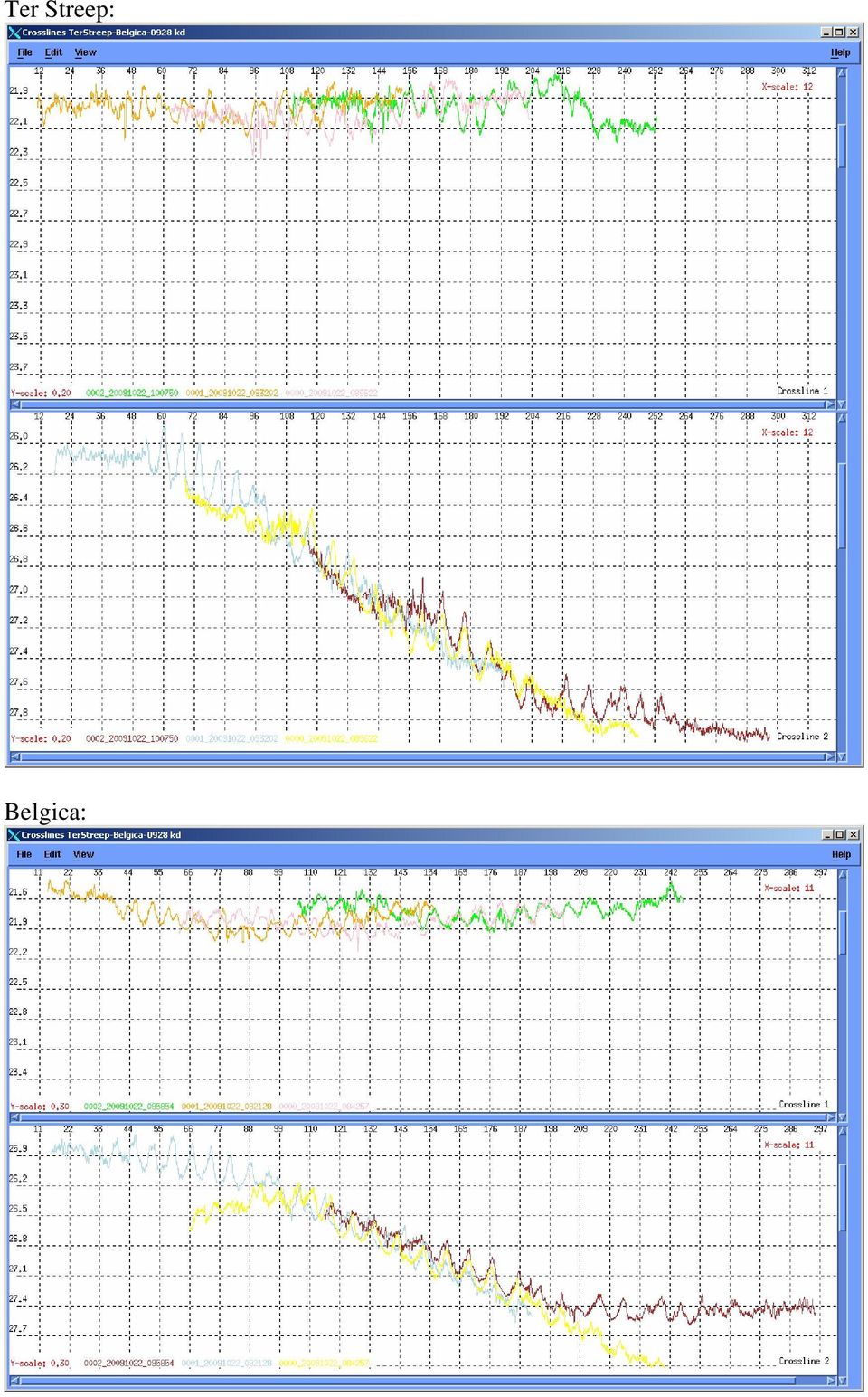
9 Evaluation of crosslines: The Belgica EM3002D appears to have a problem with the outer beams: a smile\sad face - due to sound velocity? This problem is not apparent in the Ter Streep data. Recalculated Belgica line 0 (in yellow) with svp=1500m/s (was 1498m/s oops): Line 0 in crossline 2 (yellow) looks better but other lines in crossline 1 still show a sound velocity problem. Line 1 and 2 are recalculated with svp=1500m/s (although this profile was selected on board:

10 Looks much better for crossline 1, the effect seems less positive for crossline 2. The used sound speed values in SIS are not those from the selected profile (1500 m/s). Check runtime parameters on board Belgica.
.")
11 Comparison between both vessels: (The three crosslines on the first line of the legend are the Belgica ones.) A systematic and constant difference in depth between both multibeams is observed (the Belgica profiles are app. 20cm less deep). The outer beams of the Ter Streep show less relief: due to phase ramp problem?
.")
12 Quality of bathymetry: detail of northern part of line 2: Detail of line 2 with sun shading NE: Belgica: Ter Streep:

13 Detail of line 2 with sun shading NW: Belgica: Ter Streep:

14 Evaluation of detailed bathymetry: The phase ramp problem is very apparent in the Ter Streep data: no morphology is visible in outer beams. A small heave or fault heave artifact is visible in the Belgica data, this artifact is very clear in Ter Streep data. Profile along track (yellow: Belgica blue: Ter Streep): Amplitude of the artifact: app. 10 to 20cm on the Ter Streep data.

15 Quantitative comparison: To eliminate the impact of the phase ramp problem all beams outside 50 are eliminated. Statistics for a selection of the survey (northern part -app points): Belgica: Ter Streep: Mean difference: =0.17m Based on this selection a 1mx1m grid was created for both data sets (using a simple inverse distance algorithm). The difference surface (Belgica Ter Streep) between these 1x1m grids is calculated.
: Belgica: Ter Streep: Mean difference: 20.12-19.95=0.")
16 Difference map (color scale in meter): Statistics of the difference surface: Mean difference = 0.18m

17 Evaluation: The strong across track artifact is clearly visible on the difference map. The mean difference is very close to the value measured with the Belgica in the Vandamme sluis in Zeebrugge: average difference between Belgica depth measurement and theoretic floor of lock = 0.18m. This seems to indicate that the Belgica has a systematic draught error of app. 18cm and that the Ter Streep depths are correct. The draught shift of the Belgica needs to be verified with a further calibration survey with the Belgica (the Demeysluis in Oostende is a good proposition from Kris) and a comparison with RTK calculated depths.

18 2.2. EM3002D Backscatter Strength data (BS) Processing of the 2 datasets: Belgica 0000_ _084257_Belgica.all 0001_ _092128_Belgica.all 0002_ _095854_Belgica.all Ter Streep 0000_ _085622_TerSTreep.all 0001_ _093202_TerSTreep.all 0002_ _100750_TerSTreep.all BS grid = 2x2 m Use of 3 BS mosaicking softwares: - Poseidon from Kongsberg: o Settings: o Followed by a 100 % histogram correction - Geocoder from IVS o Settings: - SonarScope from Ifremer: o Processing done by Jean-Marie Augustin from Ifremer

19 Results: Comparison of the mosaics: - As demonstrated by the figure below, the mosaics computed by Poseidon, Sonarscope and Geocoder with the Belgica and the Ter Streep datasets are quite similar. - However, the db levels change dramatically from one software to another. BELGICA TER STREEP LEGEND : POSEIDON XY scale: 1 cm ~ 160 m db scale 0 db SONARSCOPE GEOCODER -35 db Black lines : Cross sections W E : C1-C2-C3

20 Statistics: CELLS AREA (ha) MIN (db) MAX (db) MEAN (db) MEDIAN (db) STD (db) BELGICA POSEIDON BELGICA SONARSCOPE BELGICA GEOCODER TERSTREEP POSEIDON TERSTREEP SONARSCOPE TERSTREEP GEOCODER Δ MEDIAN (db) BELGICA - TER STREEP POSEIDON 0.7 BELGICA - TER STREEP SONARSCOPE 0.7 BELGICA - TER STREEP GEOCODER 2.3
 BELGICA - TER STREEP POSEIDON 0.7 BELGICA - TER STREEP SONARSCOPE 0.")
21 Cross sections: CROSS SECTION 1: BELGICA POSEIDON BELGICA SONARSCOPE BELGICA GEOCODER TERSTREEP POSEIDON TERSTREEP SONARSCOPE TERSTREEP GEOCODER CROSS SECTION 2: BELGICA POSEIDON BELGICA SONARSCOPE BELGICA GEOCODER TERSTREEP POSEIDON TERSTREEP SONARSCOPE TERSTREEP GEOCODER
22 CROSS SECTION 3: BELGICA POSEIDON BELGICA SONARSCOPE BELGICA GEOCODER TERSTREEP POSEIDON TERSTREEP SONARSCOPE TERSTREEP GEOCODER Comparison of the cross sections: - As demonstrated by the 3 cross sections, the Belgica and the Ter Streep datasets BS values are quite similar. - However, the db levels change dramatically from one software to another. - Poseidon and SonarScope results are consistent: Belgica and Ter Streep curves are very similar. - Sections across the 2 mosaics computed with GeoCoder show a quite large difference between the Belgica and the Ter Streep BS datasets. That should be investigated more in detail.
23 Calibration curves: BS VERSUS TX ANGLE: BS (db) BELGICA AVERAGE TERSTREEP AVERAGE TX ANGLE (degree) BS VERSUS BEAM #: BS (db) BELGICA AVERAGE TERSTREEP AVERAGE BEAM # BS (db) BEAM # BELGICA AVERAGE TERSTREEP AVERAGE TERSTREEP AVERAGE CORRECTED (HEAD 2 +2 db) - An offset of 2 db should be introduced for the Ter Streep Head 2. With this offset the 2 ships will have a very similar BS curve.
24
25 3. Conclusions 1. Among the runtime parameters the absorption coefficient is especially important for the backscatter recordings. Since this parameter s primarily a function of water salinity and temperature it can vary considerable. A constant monitoring of both temperature and salinity is a minimum (in a mixed environment as the Schelde estuary knowledge of the evolution in time of the vertical profiles of both parameters is needed) to obtain comparable BS data. 2. Both the Ter Streep and Belgica data (less) show a across track artifact. This could be the sign of an inadequate heave correction. A recalibration or upgrade of motion sensor is a possible solution. 3. The phase ramp problem in the Ter Streep data is very clear and needs a solution from Kongsberg. 4. The almost constant depth difference between both transducers is most probably the impact of a problem with the Belgica draught correction. The same depth difference was measured during a survey with the Belgica in the Vandamme sluis. More calibration surveys with the Belgica are necessary. 5. The recorded backscatter data from both vessels is very similar. A compensation of 2dB for head two of Ter Streep would make both datasets interchangeable. An important issue is the choice of processing software. DB levels change dramatically from one software to another. Many thanks to the crews of the Belgica and Ter Streep for their valuable cooperation on this study.
Norwegian Hydrographic Service. and. [Contractor] APPENDIX B. Technical Specifications. MAREANO Programme. [Date]
![Norwegian Hydrographic Service. and. [Contractor] APPENDIX B. Technical Specifications. MAREANO Programme. [Date]](/thumbs/31/15071572.jpg "Norwegian Hydrographic Service. and. [Contractor] APPENDIX B. Technical Specifications. MAREANO Programme. [Date]") Norwegian Hydrographic Service and [Contractor] APPENDIX B Technical Specifications MAREANO Programme [Date] Page 1 of 17 Technical Specifications Table of content: 1 Overview... 3 2 Terms and Definitions...
Norwegian Hydrographic Service and [Contractor] APPENDIX B Technical Specifications MAREANO Programme [Date] Page 1 of 17 Technical Specifications Table of content: 1 Overview... 3 2 Terms and Definitions...
1.0 INTRODUCTION 2.0 SCOPE OF WORK. DATE July 29, 2010 PROJECT No. 09-1436-5008/2000
 DATE July 29, 2010 PROJECT No. 09-1436-5008/2000 TO Geoff Sinnett Ministry of Agriculture and Lands, Crown Land Restoration Branch cc Dawn Flotten FROM Karl Manzer EMAIL kmanzer@golder.com LADYSMITH HARBOUR
Survey Sensors Hydrofest 2014. Ross Leitch Project Surveyor
 Survey Sensors Hydrofest 2014 Ross Leitch Project Surveyor Satellite Positioning Only provides position of antenna Acoustic Positioning Only provides position of transponder relative to transceiver How
Outline. Application of AUVs for Hydrography. AUVs for hydrographic surveying AUV horizontal mapping accuracy
 Application of AUVs for Hydrography Øyvind Hegrenæs, Ph.D. AUV Department Outline AUVs for hydrographic surveying AUV horizontal mapping accuracy HUGIN 1000 with HISAS 1030 SAS HiPAP 500 USBL or GPS surface
Improving Hydrographic Rate of Effort
 Improving Hydrographic Rate of Effort Presented by Scott Elson Australia s Surveying Responsibility Source: http://www.hydro.gov.au/business-publications/hydroscheme-2010-2012.pdf Company Proprietary 2
The Integration of Hydrographic and Oceanographic Data in a Marine Geographic Information System U.S. Hydro 2015
 The Integration of Hydrographic and Oceanographic Data in a Marine Geographic Information System U.S. Hydro 2015 Karen Hart CARIS USA Oceanography and Hydrography Defined Oceanography: The branch of Earth
Error Estimation in Positioning and Orientation Systems
 Error Estimation in Positioning and Orientation Systems Peter Canter Director, Applanix Marine Systems 85 Leek Crescent Richmond Hill, Ontario L4B 3B3 Telephone 905-709-4600 pcanter@applanix.com Co-Author:
This service is free for all our customers with a maintenance contract.
 PDS 2000 Hydrographic data acquisition and processing package GENERAL Reson s Hydrographic data acquisition, processing and dredge monitoring package PDS2000 is a Reson developed all-in-one software package.
www.searchmesh.net Author(s): Document owner: n/a MESH action: 2.1 Version: 1.1 Date published: File name: Language:
: Document owner: n/a MESH action: 2.1 Version: 1.1 Date published: File name: Language:") Title: Author(s): Document owner: Recommended operating guidelines (ROG) for swath bathymetry Alan Hopkins Alan Hopkins Reviewed by: Janine Guinan (MI) 07/09/07 Workgroup: n/a MESH action: 2.1 Version:
Title: Author(s): Document owner: Recommended operating guidelines (ROG) for swath bathymetry Alan Hopkins Alan Hopkins Reviewed by: Janine Guinan (MI) 07/09/07 Workgroup: n/a MESH action: 2.1 Version:
Gravir Outer, Isle of Lewis Site and Hydrographic survey report
 Gravir Outer, Isle of Lewis Site and Hydrographic survey report November 2013 The Scottish Salmon Company 8 Melville Crescent Edinburgh EH3 7JA Report No: Issued By: Mathew Laughton Checked By: Mark Edmonds
MB1 IMAGE CONTROL SOFTWARE MANUAL
 MB1 IMAGE CONTROL SOFTWARE MANUAL Version: 1.6 Teledyne Odom Hydrographic 1450 Seaboard Avenue Baton Rouge Louisiana 70810 United States of America Telephone: +1 (225) 769-3051 Fax: +1 (225) 766-5122 odom@teledyne.com
Index-Velocity Rating Development (Calibration) for H-ADCP Real-Time Discharge Monitoring in Open Channels
 for H-ADCP Real-Time Discharge Monitoring in Open Channels") Index-Velocity Rating Development (Calibration) for H-ADCP Real-Time Discharge Monitoring in Open Channels Hening Huang Teledyne RD Instruments, Inc., 14020 Stowe Drive, Poway, CA. 92064, USA (Tel: 858-842-2600,
Index-Velocity Rating Development (Calibration) for H-ADCP Real-Time Discharge Monitoring in Open Channels Hening Huang Teledyne RD Instruments, Inc., 14020 Stowe Drive, Poway, CA. 92064, USA (Tel: 858-842-2600,
New Coastal and Inland Water Mapping System Promises Significant Increases in Productivity with Virtual Real Time Map Production
 New Generation Mapper for Shallow Water Hydrography By: Pete Alleman, Thomas Chance, and Art Kleiner (printed in Sea Technology Magazine June, 1993) New Coastal and Inland Water Mapping System Promises
УДК 528 Nguyen Thanh Le APPLYING MULTIBEAM ECHO-SOUNDER SYSTEM IN MAKING MULTISCALE SEABED TOPOGRAPHY MAP IN VIETNAM
 Новый университет. 2013. 11-12(21-22). ISSN 2221-9552 УДК 528 Nguyen Thanh Le APPLYING MULTIBEAM ECHO-SOUNDER SYSTEM IN MAKING MULTISCALE SEABED TOPOGRAPHY MAP IN VIETNAM Making multiscale seabed topography
HYDROGRAPHIC ECHOSOUNDER FOR SOUNDING INLAND WATERS ANDRZEJ JEDEL, LECH KILIAN, JACEK MARSZAL, ZAWISZA OSTROWSKI, ZBIGNIEW WOJAN, KRZYSZTOF ZACHARIASZ
 HYDROGRAPHIC ECHOSOUNDER FOR SOUNDING INLAND WATERS ANDRZEJ JEDEL, LECH KILIAN, JACEK MARSZAL, ZAWISZA OSTROWSKI, ZBIGNIEW WOJAN, KRZYSZTOF ZACHARIASZ Gdańsk University of Technology, Faculty of Electronics,
Post bathymetry and stability of reef structures or measurement of seafloor in the Blue Reef project area
 LIFE06 NAT/DK/000159 - Blue Reef project Technical Final Report Annex 15 June 2013 Post bathymetry and stability of reef structures or measurement of seafloor in the Blue Reef project area 1. Introduction
Apogee Series. > > Motion Compensation and Data Georeferencing. > > Smooth Workflow. Mobile Mapping. > > Precise Trajectory and Direct Georeferencing
 Ultimate accuracy MEMS Apogee Series Inertial Navigation System Motion Sensing and Georeferencing > INS > MRU > AHRS ITAR free 0,005 RMS Apogee Series High quality, high accuracy Hydrography > > Motion
KALMAN FILTERING FOR 3 D REAL TIME DATA VISUALIZATION OF MULTIBEAM SONAR RECORDS
 Volume 6 HYDROACOUSTICS KALMAN FILTERING FOR 3 D REAL TIME DATA VISUALIZATION OF MULTIBEAM SONAR RECORDS JERZY DEMKOWICZ, MAREK MOSZYŃSKI Technical University ofgdańsk ul. Narutowicza 11/12 Gdańsk demjot@eti.pg.gda.pl
SVMon Sound Velocity Monitor Manual
 1 SVMon Sound Velocity Monitor Manual 2 1. Contents. 1. Contents... 2 2. Function... 2 3. Getting started.... 3 3.1. Starting the program.... 3 4. The main window... 3 5. The menu bar... 5 5.1. File -
User manual data files meteorological mast NoordzeeWind
 User manual data files meteorological mast NoordzeeWind Document code: NZW-16-S-4-R03 Version: 2.0 Date: 1 October 2007 Author: ing. HJ Kouwenhoven User manual data files meteorological mast NoordzeeWind
Data source, type, and file naming convention
 Exercise 1: Basic visualization of LiDAR Digital Elevation Models using ArcGIS Introduction This exercise covers activities associated with basic visualization of LiDAR Digital Elevation Models using ArcGIS.
IHO STANDARDS FOR HYDROGRAPHIC SURVEYS
 INTERNATIONAL HYDROGRAPHIC ORGANIZATION IHO STANDARDS FOR HYDROGRAPHIC SURVEYS 5 th Edition, February 2008 Special Publication No. 44 Published by the International Hydrographic Bureau MONACO INTERNATIONAL
HYDROGRAPHIC DEPARTMENT MARITIME AND PORT AUTHORITY OF SINGAPORE (MPA) (Version: July 2015)
 (Version: July 2015)") HYDROGRAPHIC DEPARTMENT MARITIME AND PORT AUTHORITY OF SINGAPORE (MPA) (Version: July 2015) GENERAL SPECIFICATIONS FOR THE CONDUCT OF HYDROGRAPHIC SURVEYS 1 Engagement of Commercial Hydrographic Surveyor
HYDROGRAPHIC DEPARTMENT MARITIME AND PORT AUTHORITY OF SINGAPORE (MPA) (Version: July 2015) GENERAL SPECIFICATIONS FOR THE CONDUCT OF HYDROGRAPHIC SURVEYS 1 Engagement of Commercial Hydrographic Surveyor
The Arctic-2010 cruise: bathymetric survey for delineation of the extended continental shelf of the Russian Federation in the Arctic
 The Arctic-2010 cruise: bathymetric survey for delineation of the extended continental shelf of the Russian Federation in the Arctic Sergey Alekseev 1, Ivan Glumov 2, Andrey Morozov 3, Konstantin Stavrov
ICES Cooperative Research Report. Description of the ICES HAC Standard Data Exchange Format, Version 1.60. No. 278. December 2005
 ICES Cooperative Research Report Rapport des Recherches Collectives No. 278 December 2005 Description of the ICES HAC Standard Data Exchange Format, Version 1.60 I. H. McQuinn, D. Reid, L. Berger, N. Diner,
Doppler. Doppler. Doppler shift. Doppler Frequency. Doppler shift. Doppler shift. Chapter 19
 Doppler Doppler Chapter 19 A moving train with a trumpet player holding the same tone for a very long time travels from your left to your right. The tone changes relative the motion of you (receiver) and
HDS Gen2 RTM 4.0 software update
 HDS Gen2 RTM 4.0 software update The HDS RTM 4.0 software update enables autopilot control of outboard motors and includes features for Jeppesen 4D charts. Outboard motor autopilot To use outboard autopilot
NEW DIGITAL TERRAIN MODELING (DTM) TOOLS FOR CABLE ROUTE PLANNING by Dr. Jose M. Andres Makai Ocean Engineering Inc.
 TOOLS FOR CABLE ROUTE PLANNING by Dr. Jose M. Andres Makai Ocean Engineering Inc.") NEW DIGITAL TERRAIN MODELING (DTM) TOOLS FOR CABLE ROUTE PLANNING by Dr. Jose M. Andres Makai Ocean Engineering Inc. EXISTING CABLE ROUTE PLANNING TOOLS In recent years, methods used for submarine cable
NEW DIGITAL TERRAIN MODELING (DTM) TOOLS FOR CABLE ROUTE PLANNING by Dr. Jose M. Andres Makai Ocean Engineering Inc. EXISTING CABLE ROUTE PLANNING TOOLS In recent years, methods used for submarine cable
Automatic Labeling of Lane Markings for Autonomous Vehicles
 Automatic Labeling of Lane Markings for Autonomous Vehicles Jeffrey Kiske Stanford University 450 Serra Mall, Stanford, CA 94305 jkiske@stanford.edu 1. Introduction As autonomous vehicles become more popular,
INVITATION TO TENDER Multibeam
 INVITATION TO TENDER Multibeam (Restricted procedure) 1. Introduction The Geological Survey of Denmark and Greenland (GEUS) intends to purchase a complete Multibeam system with acquisition and processing
'Developments and benefits of hydrographic surveying using multispectral imagery in the coastal zone
 Abstract With the recent launch of enhanced high-resolution commercial satellites, available imagery has improved from four-bands to eight-band multispectral. Simultaneously developments in remote sensing
How To Fuse A Point Cloud With A Laser And Image Data From A Pointcloud
 REAL TIME 3D FUSION OF IMAGERY AND MOBILE LIDAR Paul Mrstik, Vice President Technology Kresimir Kusevic, R&D Engineer Terrapoint Inc. 140-1 Antares Dr. Ottawa, Ontario K2E 8C4 Canada paul.mrstik@terrapoint.com
Index-Velocity Rating Development for Rapidly Changing Flows in an Irrigation Canal Using Broadband StreamPro ADCP and ChannelMaster H-ADCP
 Index-Velocity Rating Development for Rapidly Changing Flows in an Irrigation Canal Using Broadband StreamPro ADCP and ChannelMaster H-ADCP HENING HUANG, RD Instruments, 9855 Businesspark Avenue, San Diego,
Hydrographic Survey of the Keith Lake-Salt Bayou System
 Hydrographic Survey of the Keith Lake-Salt Bayou System April 2007 Survey Prepared by: The Texas Water Development Board December 2007 Texas Water Development Board J. Kevin Ward, Executive Administrator
Jason-2 GDR Quality Assessment Report. Cycle 059 07-02-2010 / 17-02-2010. M. Ablain, CLS. P. Thibaut, CLS
 Jason-2 GDR Quality Assessment Report Cycle 059 07-02-2010 / 17-02-2010 Prepared by : S. Philipps, CLS M. Ablain, CLS P. Thibaut, CLS Accepted by : Approved by : DT/AQM, CLS E. Bronner, CNES Edition 01.0,
E190Q Lecture 5 Autonomous Robot Navigation
 E190Q Lecture 5 Autonomous Robot Navigation Instructor: Chris Clark Semester: Spring 2014 1 Figures courtesy of Siegwart & Nourbakhsh Control Structures Planning Based Control Prior Knowledge Operator
EVIDENCE PHOTOGRAPHY TEST SPECIFICATIONS MODULE 1: CAMERA SYSTEMS & LIGHT THEORY (37)
") EVIDENCE PHOTOGRAPHY TEST SPECIFICATIONS The exam will cover evidence photography involving crime scenes, fire scenes, accident scenes, aircraft incident scenes, surveillances and hazardous materials scenes.
EVIDENCE PHOTOGRAPHY TEST SPECIFICATIONS The exam will cover evidence photography involving crime scenes, fire scenes, accident scenes, aircraft incident scenes, surveillances and hazardous materials scenes.
Testing thermo-acoustic sound generation in water with proton and laser beams
 International ARENA Workshop DESY, Zeuthen 17th 19th of May 25 Testing thermo-acoustic sound generation in water with proton and laser beams Kay Graf Universität Erlangen-Nürnberg Physikalisches Institut
Introduction to Imagery and Raster Data in ArcGIS
 Esri International User Conference San Diego, California Technical Workshops July 25, 2012 Introduction to Imagery and Raster Data in ArcGIS Simon Woo slides Cody Benkelman - demos Overview of Presentation
GEOScaN Remote Data Acquisition for Hydrographic, Topographic and GIS Surveying
 GEOScaN Remote Data Acquisition for Hydrographic, Topographic and GIS Surveying Laurence WATERHOUSE, United Kingdom Key words: remote sensing, hydrographic, laser scanning, GIS SUMMARY British Waterways
StructureScan 3D. User Guide ENGLISH. www.simrad-yachting.com www.lowrance.com
 StructureScan 3D User Guide ENGLISH www.simrad-yachting.com www.lowrance.com Contents 5 About StructureScan 3D 7 Basic operation 7 Selecting the StructureScan source 7 Zooming 8 Stopping/pausing sonar
DELPH v3.0. seabed mapping software suite
 DELPH v3.0 seabed mapping software suite DELPH seabed mapping software suite DELPH SEISMIC, DELPH SONAR and DELPH MAG are complete software packages with dedicated acquisition, processing and interpretation
Applying MapCalc Map Analysis Software
 Applying MapCalc Map Analysis Software Using MapCalc s Shading Manager for Displaying Continuous Maps: The display of continuous data, such as elevation, is fundamental to a grid-based map analysis package.
Good Practice for Hydrographic Surveys in New Zealand Ports and Harbours. Maritime Safety MARITIME SAFETY AUTHORITY OF NEW ZEALAND Kia Maanu Kia Ora
 FINAL GUIDELINES OF Good Practice for Hydrographic Surveys in New Zealand Ports and Harbours KEEPING YOUR SEA SAFE FOR LIFE Maritime Safety MARITIME SAFETY AUTHORITY OF NEW ZEALAND Kia Maanu Kia Ora Disclaimer:
Challenges of ROV System Integration for Deep Water Habitat Mapping
 Mobile & Marine Robotics Research Centre Challenges of ROV System Integration for Deep Water Habitat Mapping University of Limerick Mapping cold water corals at 800-1,200 m on the margins of the continental
Satellite Derived Bathymetry
 11 th CSPWG MEETING 28 April, 2015 CSPCWG10-08.7A Submitted by: Executive Summary: Related Documents: Related Projects: Paper for Consideration by CSPCWG Satellite Derived Bathymetry UK CSPCWG is invited
The APOLLO cloud product statistics Web service The APOLLO cloud product statistics Web service
 The APOLLO cloud product statistics Web service Introduction DLR and Transvalor are preparing a new Web service to disseminate the statistics of the APOLLO cloud physical parameters as a further help in
WSP013_WASSP_Brochure 190x210.indd 2
 WSP013_WASSP_Brochure 190x210.indd 2 11/03/13 4:48 PM Taking the world by storm. WSP013_WASSP_Brochure 190x210.indd 3 EVERY NOW AND THEN, GROUND BREAKING ADVANCES IN TECHNOLOGY EMERGE AND LEAVE A LASTING
Robot Perception Continued
 Robot Perception Continued 1 Visual Perception Visual Odometry Reconstruction Recognition CS 685 11 Range Sensing strategies Active range sensors Ultrasound Laser range sensor Slides adopted from Siegwart
Institute of Natural Resources Departament of General Geology and Land use planning Work with a MAPS
 Institute of Natural Resources Departament of General Geology and Land use planning Work with a MAPS Lecturers: Berchuk V.Y. Gutareva N.Y. Contents: 1. Qgis; 2. General information; 3. Qgis desktop; 4.
telemetry Rene A.J. Chave, David D. Lemon, Jan Buermans ASL Environmental Sciences Inc. Victoria BC Canada rchave@aslenv.com I.
 Near real-time transmission of reduced data from a moored multi-frequency sonar by low bandwidth telemetry Rene A.J. Chave, David D. Lemon, Jan Buermans ASL Environmental Sciences Inc. Victoria BC Canada
Notices to Mariners. OSTEND MARCH 27th 2014 NR. 07
 Notices to Mariners + OSTEND MARCH 27th 2014 NR. 07 1 >07/118 CANCELLED NOTICES NtM nr. Cancelled Charts 2013-16/258 (T) Approach Western Scheldt - Vicinity Blighbank and Lodewijkbank - ELIA project BelgianOffshore
Aquaculture Monitoring Standard
 Aquaculture Monitoring Standard Fisheries and Oceans Canada Date modified: 2015-07-22 Table of Contents Introduction 3 Definitions 3 I. Survey for Baseline Information [AAR section 8] 4 Predicted Contours
series 5350 5351 Materials Body: 1/2, 3/4 and 1 : dezincification resistant alloy brass EN 12165 CW617N
 Pre-adjustable pressure reducing valves with self-contained cartridge - series CCREDITED ISO 9 FM ISO 9 No. CLEFFI / GB replaces / GB Function Pressure reducing valves are devices which, when installed
NaviPac Alarm Monitor
 NaviPac Alarm Monitor The NaviPac alarm monitor utilizes display and control of user defined and system alarms in NaviPac. The window may be opened from NaviPac Online View, Alarm Monitor Data Acquisition
T-100-R Installation Guide
 T-100-R Installation Guide Table of Contents Page 2 Overview T-100-R Z-Wave Thermostat 3-4 Installation HVAC System Setup 6 Installer Settings Menu Items 7-9 Installer Settings Summary 10-11 Wiring Standard
Advanced Image Management using the Mosaic Dataset
 Esri International User Conference San Diego, California Technical Workshops July 25, 2012 Advanced Image Management using the Mosaic Dataset Vinay Viswambharan, Mike Muller Agenda ArcGIS Image Management
(0008854) A981653 REV B. 4125 system setup and deployment quick start guide
 A981653 REV B. 4125 system setup and deployment quick start guide") (0008854) A981653 REV B 4125 system setup and deployment quick start guide OPERATION IN AIR Do not operate the system while the tow fish in air for extended periods. The system may be enabled to transmit
(0008854) A981653 REV B 4125 system setup and deployment quick start guide OPERATION IN AIR Do not operate the system while the tow fish in air for extended periods. The system may be enabled to transmit
HV Submarine Cable Systems Design, Testing and Installation
 HV Submarine Cable Systems Design, Testing and Installation CIGRE Ireland Technical Seminar 6 th October 2010 Robert Donaghy Senior Consultant Engineer, ESB International Presentation Overview Applications
Tidal Correction Using GPS Determination of the Chart Datum. October 9, FIG Congress 2006
 Tidal Correction Using GPS Determination of the Chart Datum October 9, FIG Congress 2006 Inhalt The Traditional Way of Tide Correction Tide Correction Using GNSS Task I: Realisation of the Chart Datum
Autos Limited Ghana Vehicle Tracking Business Proposal
 Autos Limited Ghana Vehicle Tracking Business Proposal Executive Summary Our Understanding of Your Goals We understand that you or your business needs to monitor all your vehicles or company's to minimize
SEABEAM ELAC1185 MULTIBEAM ECHOSOUNDER
 SEABEAM ELAC1185 MULTIBEAM ECHOSOUNDER BENTOS Servicios y Equipos Marinos Ltda. Avda. Suecia 3005, Ñuñoa, Santiago Telephone: (56 2) 296 373 60 Fax: (56 2) 296 373 77 E-mail: info@bentos.cl GENERAL ASPECTS
Using Optech LMS to Calibrate Survey Data Without Ground Control Points
 Challenge An Optech client conducted an airborne lidar survey over a sparsely developed river valley. The data processors were finding that the data acquired in this survey was particularly difficult to
Simulation of Offshore Structures in Virtual Ocean Basin (VOB)
") Simulation of Offshore Structures in Virtual Ocean Basin (VOB) Dr. Wei Bai 29/06/2015 Department of Civil & Environmental Engineering National University of Singapore Outline Methodology Generation of
Simulation of Offshore Structures in Virtual Ocean Basin (VOB) Dr. Wei Bai 29/06/2015 Department of Civil & Environmental Engineering National University of Singapore Outline Methodology Generation of
RPS 8000. High Accuracy Resonant Pressure Sensor. GE Measurement & Control Solutions. Features:
 GE Measurement & Control Solutions RPS 8000 High Accuracy Resonant Pressure Sensor For over 35 years, Druck has manufactured precision pressure sensors with a capability to meet critical applications in
Is Multibeam Water Column Data Really Worth the Disk Space?
 Is Multibeam Water Column Data Really Worth the Disk Space? Authors: GEE Lindsay 1, DOUCET Maurice 1, PARKER David 2, WEBER Tom 3, and BEAUDOIN Jonathan 3 1. Quality Positioning Services, Inc., 104 Congress
Cross-beam scanning system to detect slim objects. 100 mm 3.937 in
 891 Object Area Sensor General terms and conditions... F-17 Related Information Glossary of terms... P.1359~ Sensor selection guide...p.831~ General precautions... P.1405 PHOTO PHOTO Conforming to EMC
DEPTH AND POSITION ERROR BUDGETS FOR MULTIBEAM ECHOSOUNDING
 International Hydrographic Review, Monaco, LXX1I(2), September 1995 DEPTH AND POSITION ERROR BUDGETS FOR MULTIBEAM ECHOSOUNDING by Rob H A R E1 Abstract Depth error budgets are commonplace for single-beam
DOING PHYSICS WITH MATLAB COMPUTATIONAL OPTICS RAYLEIGH-SOMMERFELD DIFFRACTION INTEGRAL OF THE FIRST KIND
 DOING PHYSICS WITH MATLAB COMPUTATIONAL OPTICS RAYLEIGH-SOMMERFELD DIFFRACTION INTEGRAL OF THE FIRST KIND THE THREE-DIMENSIONAL DISTRIBUTION OF THE RADIANT FLUX DENSITY AT THE FOCUS OF A CONVERGENCE BEAM
AP1 Oscillations. 1. Which of the following statements about a spring-block oscillator in simple harmonic motion about its equilibrium point is false?
 1. Which of the following statements about a spring-block oscillator in simple harmonic motion about its equilibrium point is false? (A) The displacement is directly related to the acceleration. (B) The
Charting the Secret World of the Ocean Floor. The GEBCO Project 1903-2003
 Charting the Secret World of the Ocean Floor. The GEBCO Project 1903-2003 1 Frontiers in Sea Floor Mapping and Visualization By Larry A. Mayer Center for Coastal and Ocean Mapping, University of New Hampshire
ULS Installation Software v5.24.38 Release Notes
 ULS Installation Software v5.24.38 Release Notes The following document contains information for:? Software Corrections Version 5.24.38 Corrections for v5.21.33-5.24.37 and upgrade to all 2.N.N and 4.N.N
NaviSuite Offline Training. NaviEdit NaviModel - NaviPlot
 NaviSuite Offline Training NaviEdit NaviModel - NaviPlot Training Schedule: Day 1: Day 2: Day 3: Day 4: Introduction Installation of Software NaviEdit NaviEdit (Continued) Patchtest Calibration NaviModel
The APOLLO cloud product statistics Web service
 The APOLLO cloud product statistics Web service Introduction DLR and Transvalor are preparing a new Web service to disseminate the statistics of the APOLLO cloud physical parameters as a further help in
IMO. MSC/Circ.707 19 October 1995. Ref. T1/2.04 GUIDANCE TO THE MASTER FOR AVOIDING DANGEROUS SITUATIONS IN FOLLOWING AND QUARTERING SEAS
 INTERNATIONAL MARITIME ORGANIZATION 4 ALBERT EMBANKMENT LONDON SE1 7SR Telephone: 020-7735 7611 Fax: 020-7587 3210 Telex: 23588 IMOLDN G IMO E MSC/Circ.707 19 October 1995 Ref. T1/2.04 GUIDANCE TO THE
Which month has larger and smaller day time?
 ACTIVITY-1 Which month has larger and smaller day time? Problem: Which month has larger and smaller day time? Aim: Finding out which month has larger and smaller duration of day in the Year 2006. Format
Synthetic Sensing: Proximity / Distance Sensors
 Synthetic Sensing: Proximity / Distance Sensors MediaRobotics Lab, February 2010 Proximity detection is dependent on the object of interest. One size does not fit all For non-contact distance measurement,
Impedance 50 (75 connectors via adapters)
") VECTOR NETWORK ANALYZER PLANAR TR1300/1 DATA SHEET Frequency range: 300 khz to 1.3 GHz Measured parameters: S11, S21 Dynamic range of transmission measurement magnitude: 130 db Measurement time per point:
VECTOR NETWORK ANALYZER PLANAR TR1300/1 DATA SHEET Frequency range: 300 khz to 1.3 GHz Measured parameters: S11, S21 Dynamic range of transmission measurement magnitude: 130 db Measurement time per point:
Heat Transfer. Energy from the Sun. Introduction
 Introduction The sun rises in the east and sets in the west, but its exact path changes over the course of the year, which causes the seasons. In order to use the sun s energy in a building, we need to
v Software Release Notice -. Acquired Software
 v Software Release Notice -. Acquired Software 1. Software Name: Software Version: ArcView GIs@ 3.3 2. Software Function: ArcView GIS 3.3, developed by Environmental Systems Research Institute, Inc. (ESRI@),
Free Fall: Observing and Analyzing the Free Fall Motion of a Bouncing Ping-Pong Ball and Calculating the Free Fall Acceleration (Teacher s Guide)
") Free Fall: Observing and Analyzing the Free Fall Motion of a Bouncing Ping-Pong Ball and Calculating the Free Fall Acceleration (Teacher s Guide) 2012 WARD S Science v.11/12 OVERVIEW Students will measure
Free Fall: Observing and Analyzing the Free Fall Motion of a Bouncing Ping-Pong Ball and Calculating the Free Fall Acceleration (Teacher s Guide) 2012 WARD S Science v.11/12 OVERVIEW Students will measure
5. Side Scan. I. Side Scan Hardware. A. Specifying Devices in Side Scan Hardware
 5. Side Scan I. Side Scan Hardware The SIDE SCAN HARDWARE program is used to install those devices that are specific to side scan surveys. HYPACK collects analog and digital side scan data through the
The Map Grid of Australia 1994 A Simplified Computational Manual
 The Map Grid of Australia 1994 A Simplified Computational Manual The Map Grid of Australia 1994 A Simplified Computational Manual 'What's the good of Mercator's North Poles and Equators, Tropics, Zones
IMCA Competence Assessment Portfolio May 2012
 S/S30/000/01 Safety (S30 refers to Grade II core competences which are applicable to roles S31, S32, S33, S34 and S35, as described in IMCA C 004) Safe working practices Identify different areas in the
Automation System TROVIS 6400 TROVIS 6493 Compact Controller
 Automation System TROVIS 6400 TROVIS 6493 Compact Controller For panel mounting (front frame 48 x 96 mm/1.89 x 3.78 inch) Application Digital controller to automate industrial and process plants for general
Addendum for Zeus Touch software updates
 *988-10802-001* Addendum for Zeus Touch software updates www.bandg.com 2 ZC1 Remote Controller 2 New chart features 5 Fusion Link Support 6 NMEA 0183 Data logging 6 Damping 7 Configuring the ZG100 GPS
The Coastal Hydrographic Service (HVAS) Of Oostende
 Of Oostende") Afdeling Waterwegen Kust - Hydrografie - Oostende H y d ro g ra p h ie S u rvey in g B elgian users & user requirem ents The data logging and processing o f bathymetric information along the Belgian coast
Afdeling Waterwegen Kust - Hydrografie - Oostende H y d ro g ra p h ie S u rvey in g B elgian users & user requirem ents The data logging and processing o f bathymetric information along the Belgian coast
Overview of the IR channels and their applications
 Ján Kaňák Slovak Hydrometeorological Institute Jan.kanak@shmu.sk Overview of the IR channels and their applications EUMeTrain, 14 June 2011 Ján Kaňák, SHMÚ 1 Basics in satellite Infrared image interpretation
Calibration of Dallas sensors
 Calibration of Dallas sensors Mariusz Sapinski INFN Sezione di Roma1 Roma, Italy (April 2006) 1. Objectives The goal of this work is to perform a calibration of Dallas sensors. Nine Dallas sensors are
The Application of a Remotely-Operated Hydrographic Survey Boat for Tailings Facility Bathymetry
 ABSTRACT 63 The Application of a Remotely-Operated Hydrographic Survey Boat for Tailings Facility Bathymetry Dr. Adrian McDonald The Oceanscience Group, USA ABSTRACT As the methods available for surveying
Lawrence H. Haselmaier, Jr. Naval Oceanographic Office U.S. Hydrographic Conference 2015 20 February 2015
 Lawrence H. Haselmaier, Jr. Naval Oceanographic Office U.S. Hydrographic Conference 2015 20 February 2015 Adding an Ellipsoid Reference to AUV Multibeam Data to Meet Hydrographic Standards Abstract: One
Instruction manual EM Series Multibeam echo sounders
 Instruction manual EM Series Multibeam echo sounders Datagram formats Kongsberg EM Series Multibeam echo sounder EM datagram formats 850-160692/S May 2015 Kongsberg Maritime AS Document history Document
3D visualization for pelagic fisheries research and assessment
 ICES Journal of Marine Science, 59: 216 225. 2002 doi:10.1006/jmsc.2001.1125, available online at http://www.idealibrary.com on 3D visualization for pelagic fisheries research and assessment Larry Mayer,
A METHOD FOR COMPARING BATHYMETRIC SURVEY DATA TO DETERMINE CHANGES IN SEDIMENT ELEVATION
 page 3 A METHOD FOR COMPARING BATHYMETRIC SURVEY DATA TO DETERMINE CHANGES IN SEDIMENT ELEVATION J Herzog, Floyd Snider, Seattle, USA and A S Bradshaw, Department of Ocean Engineering, University of Rhode
Chapter Overview. Bathymetry. Measuring Bathymetry. Echo Sounding Record. Measuring Bathymetry. CHAPTER 3 Marine Provinces
 Chapter Overview CHAPTER 3 Marine Provinces The study of bathymetry charts ocean depths and ocean floor topography. Echo sounding and satellites are efficient bathymetric tools. Most ocean floor features
Swath-sounding techniques for near shore surveying C. R. Bates 1 and P. Byham 2
 Swath-sounding techniques for near shore surveying C. R. Bates 1 and P. Byham 2 1 School of Geography and Geosciences, University of St Andrews, Fife, KY16 9AL, crb@st-and.ac.uk 2 Submetrix Ltd., Unit
Chapter 07 Test A. Name: Class: Date: Multiple Choice Identify the choice that best completes the statement or answers the question.
 Class: Date: Chapter 07 Test A Multiple Choice Identify the choice that best completes the statement or answers the question. 1. An example of a vector quantity is: a. temperature. b. length. c. velocity.
SHOALS Toolbox: Software to Support Visualization and Analysis of Large, High-Density Data Sets
 SHOALS Toolbox: Software to Support Visualization and Analysis of Large, High-Density Data Sets by Jennifer M. Wozencraft, W. Jeff Lillycrop, and Nicholas C. Kraus PURPOSE: The Coastal and Hydraulics Engineering
Earth Coordinates & Grid Coordinate Systems
 Earth Coordinates & Grid Coordinate Systems How do we model the earth? Datums Datums mathematically describe the surface of the Earth. Accounts for mean sea level, topography, and gravity models. Projections
Mobile Laser Scanning on Board Hydrographic Survey Vessels - Applications and Accuracy Investigations -
 Mobile Laser Scanning on Board Hydrographic Survey Vessels - Applications and Accuracy Investigations - Volker BÖDER, Thomas P. KERSTEN, Thomas THIES, Arne SAUER, Germany Key words: echo sounder, GNSS,