Mapping Active Faults in the Houston Area using LIDAR Data
|
|
|
- Marylou Leonard
- 10 years ago
- Views:
Transcription
1 Mapping Active Faults in the Houston Area using LIDAR Data

2 Richard Engelkemeir, University of Houston Dr. Shuhab Khan, University of Houston Dr. Carl Norman, University of Houston

3 LIDAR DEM of Harris County. LIDAR mapped faults, salt dome locations.

4 Hillshade of LIDAR DEM for northwestern Harris County, shown without faults.

5 Geologic Overview Salt deposited during extension prior to sea floor spreading Deposition prograding into basin Faulting initiating along shelf margin Depositional and salt role in faulting

6 Regional map, showing the Northwestern Gulf of Mexico. The labels indicate the primary depocenters, showing the prograding into the basin along with the eastward migration of depocenters. The salt basin limits are shown. The salt basin extends from the Luling-Mexia-Talco faults to the Sigsbee escarpment.

7 Cenozoic shelf margins (adapted from Winker, 1982). Note progradation of shelf margins throughout Cenozoic. Most active growth faulting occurs at shelf margin. Significant subsidence due to loading of sediments. Late Cretaceous Woodbine, Tuscaloosa; Paleocene Midway, Lower Wilcox; Eocene Upper Wilcox, Claiborne, Jackson; Oligocene- Vicksburg, Frio, Anahuac (yellow) Houston on shelf margin; Miocene; Plio-Pleistocene (green). Paleogene predominantly in South Texas; Neogene in East Texas and Louisiana.
 Houston on shelf margin; Miocene; Plio-Pleistocene (green).")
8 Deposition and salt migration (from Lowrie et al., 1996). Salt deposited during period of extension which preceded sea-floor spreading in Middle Jurassic. The weight of the sediments has displaced the salt. Note that ulk of slat now to the South. Also note growth faults. The faults typically dip into the basin. We see the general basinward progression of deposition. Tectonic subsidence amplified by sediment loading. Is Basement high the northern half of the split mantle plume noted in Bird et al., 2005?

9 General Dynamical Model
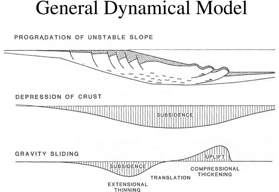
10 Addicks Fault System Longpoint fault Salt Dome Proposed model for Houston area faults, showing relationship to salt in subsurface. The active surface faults are shown as continuing downward into growth faults. The growth faults sole out in structures resulting from the withdrawal of salt. Some of the salt rises in salt domes downdip of the faults. Salt

11 LIDAR Fault Interpretation Fault Mapping - Hillshading shows elevation contrast DEM refinement - Raw Data (30 M points/quarter quadrangle) - Use coarse DEM for weighted grid interpolation - Ground cover may provide additional controls Field Confirmation

12 Long Point Fault at Bunker Hill. (a) LIDAR; (b) LIDAR hillshade; (c) profile along Bunker Hill; arrow shows location on DEM; (d) photo looking updip along profile in c. Note tilted sidewalk slabs along scarp face.

13 LIDAR: 15 foot grid cells Slope map. Slope is maximum spatial rate of change of surface Aspect maps show the direction of slope. Better spatial resolution will result in enhanced slopes since less averaging. E-W streets (from south) : IH 10, Westview, Longpoint NS streets (from W): Gessner, Bunker Hill, Blalock. Orthophoto: 1 foot grid cells. Have zoomed in and can see trees (January 2002 orthophoto)
 : IH 10, Westview, Longpoint NS streets (from W): Gessner, Bunker Hill,")
14 LIDAR shows Longpoint Fault

15 Fault not Visible on Orthophoto

16 This house on Morehead has had several foundation repair jobs over the years.

17 Witte. West side of pit (behind fence). Looking South
.")
18 St Francis kink. Hillshade image showing Long Point fault where it crosses St. Francis Street. East-west segment of trace on east side of St. Francis runs along property line between 2 houses. The kink in the trace thus appears to be manmade. With ongoing fault movement the house on the south side of the scarp is at risk.

19 Looking E. Ramp on property line explains kink

20 Long Point fault splits. LIDAR hillshade image of Long Point fault where it crosses Long Point. Here the scarp splits into several branches.

21 1) Looking N along Huge Oaks towards primary scarp.
22 Lee Road fault. This fault is an antithetic fault (up-to-the-coast) southeast of Bush Intercontinental Airport. It is presently active, and residents report ongoing foundation problems. There may be an active segment of the master fault running through the airport.
23 Looking E across scarp on Truxton
24 Gathering GPR data with my thesis advisor, Dr. Shuhab Khan. We used high frequency GPR (400 MHz) but were unable to find clear evidence for faulting in the subsurface. My wife and/or son accompanied me on most of my field visits.
25 Future Research InSAR Attempt to measure fault displacements. See whether salt domes are actively rising GPR, seismic Try and image faults in near-surface Test potential fault picks
2D Resistivity Imaging Investigation of Long Point, Katy- Hockley, Tomball and Pearland Faults
 Success with Geophysics: 2D Resistivity Imaging 2D Resistivity Imaging Investigation of Long Point, Katy- Hockley, Tomball and Pearland Faults Barry J. Allred, USDA/ARS, Soil Drainage Research Unit, Columbus,
Growth Faulting, Associated Geologic Hazards, Economic & Regulatory Impact, and Methods of Investigation for the Houston, Texas Area
 Growth Faulting, Associated Geologic Hazards, Economic & Regulatory Impact, and Methods of Investigation for the Houston, Texas Area GSA / AEG-Tx Growth Fault Symposium Texas A&M University, College Station,
How Did These Ocean Features and Continental Margins Form?
 298 10.14 INVESTIGATION How Did These Ocean Features and Continental Margins Form? The terrain below contains various features on the seafloor, as well as parts of three continents. Some general observations
TECTONICS ASSESSMENT
 Tectonics Assessment / 1 TECTONICS ASSESSMENT 1. Movement along plate boundaries produces A. tides. B. fronts. C. hurricanes. D. earthquakes. 2. Which of the following is TRUE about the movement of continents?
Dip is the vertical angle perpendicular to strike between the imaginary horizontal plane and the inclined planar geological feature.
 Geological Visualization Tools and Structural Geology Geologists use several visualization tools to understand rock outcrop relationships, regional patterns and subsurface geology in 3D and 4D. Geological
Data source, type, and file naming convention
 Exercise 1: Basic visualization of LiDAR Digital Elevation Models using ArcGIS Introduction This exercise covers activities associated with basic visualization of LiDAR Digital Elevation Models using ArcGIS.
Plate Tectonics: Ridges, Transform Faults and Subduction Zones
 Plate Tectonics: Ridges, Transform Faults and Subduction Zones Goals of this exercise: 1. review the major physiographic features of the ocean basins 2. investigate the creation of oceanic crust at mid-ocean
Search and Discovery Article #40256 (2007) Posted September 5, 2007. Abstract
 Posted September 5, 2007. Abstract") Evaluating Water-Flooding Incremental Oil Recovery Using Experimental Design, Middle Miocene to Paleocene Reservoirs, Deep-Water Gulf of Mexico* By Richard Dessenberger 1, Kenneth McMillen 2, and Joseph
Evaluating Water-Flooding Incremental Oil Recovery Using Experimental Design, Middle Miocene to Paleocene Reservoirs, Deep-Water Gulf of Mexico* By Richard Dessenberger 1, Kenneth McMillen 2, and Joseph
Chapter 9: Earth s Past
 Chapter 9: Earth s Past Vocabulary 1. Geologic column 2. Era 3. Period 4. Epoch 5. Evolution 6. Precambrian time 7. Paleozoic era 8. Shield 9. Stromatolite 10. Invertebrate 11. Trilobite 12. Index fossil
Investigation 6: What happens when plates collide?
 Tectonics Investigation 6: Teacher Guide Investigation 6: What happens when plates collide? In this activity, students will use the distribution of earthquakes and volcanoes in a Web GIS to learn about
Create a folder on your network drive called DEM. This is where data for the first part of this lesson will be stored.
 In this lesson you will create a Digital Elevation Model (DEM). A DEM is a gridded array of elevations. In its raw form it is an ASCII, or text, file. First, you will interpolate elevations on a topographic
Transform Boundaries
 Lecture 7 Plates and Mantle Plumes Transform Boundaries Transform boundaries occur where one segment of rigid lithosphere slides horizontally past another in response to stresses in the lithosphere. The
Regents Questions: Plate Tectonics
 Earth Science Regents Questions: Plate Tectonics Name: Date: Period: August 2013 Due Date: 17 Compared to the oceanic crust, the continental crust is (1) less dense and more basaltic (3) more dense and
3D Hybrid Gravity Inversion for Base of Salt Modelling
 3D Hybrid Gravity Inversion for Base of Salt Modelling A base of salt test with gravity gradients Gerry Connard, Rob Ellis Tom Popowski and Gaud Pouliquen* Non-Seismic Geophysics, Finding Petroleum Event
Step 2: Learn where the nearest divergent boundaries are located.
 What happens when plates diverge? Plates spread apart, or diverge, from each other at divergent boundaries. At these boundaries new ocean crust is added to the Earth s surface and ocean basins are created.
There are numerous seams on the surface of the Earth
 Plate Tectonics and Continental Drift There are numerous seams on the surface of the Earth Questions and Topics 1. What are the theories of Plate Tectonics and Continental Drift? 2. What is the evidence
Sand Injectites in the North Sea and the Atlantic margin Giant fields - Infill targets - Drilling hazards - Migration paths
 FORCE Conference: Underexplored Plays, NPD, Stavanger 8-9 April 2015 Sand Injectites in the North Sea and the Atlantic margin Giant fields - Infill targets - Drilling hazards - Migration paths Mads Huuse
Opportunities for the generation of high resolution digital elevation models based on small format aerial photography
 Opportunities for the generation of high resolution digital elevation models based on small format aerial photography Boudewijn van Leeuwen 1, József Szatmári 1, Zalán Tobak 1, Csaba Németh 1, Gábor Hauberger
Hot tpot tproject A Demonstration of How Groundwater Chemistry is being Used to Discover a Gravel Covered Gold Deposit
 Hot tpot tproject A Demonstration of How Groundwater Chemistry is being Used to Discover a Gravel Covered Gold Deposit April 2, 2009 General Cautionary Statement Warning! The business of Gold Exploration
Growth Faulting and Subsidence in the Houston, Texas Area:
 Growth Faulting and Subsidence in the Houston, Texas Area: A Guide to the Origins, Relationships, Hazards, Potential Impacts, and Methods of Investigation For the Graduates and Members of The Institute
New insights brought by broadband seismic data on the Brazil-Angola conjugate margins
 New insights brought by broadband seismic data on the Brazil-Angola conjugate margins Gregor Duval*, Jaswinder Mann, Lauren Houston and Steven Bowman Content Introductory remarks: why does the seismic
Groundwater exploration WATEX applications with Ground Penetrating Radars. Dr.Saud Amer USGS Dr.Alain Gachet Radar Technologies France
 Groundwater exploration WATEX applications with Ground Penetrating Radars Dr.Saud Amer USGS Dr.Alain Gachet Radar Technologies France GPR is a technology that allows rapid and non destructive collection
Structural Origin of the Claremont Anticline, Nova Scotia: Has new seismic solved an old problem?
 Structural Origin of the Claremont Anticline, Nova Scotia: Has new seismic solved an old problem? J.P.(Paddy) Chesterman Devon Canada Corporation, 301 400-3rd Avenue SW, Calgary, AB, T2P 4H2 [email protected]
Geol 101: Physical Geology PAST EXAM QUESTIONS LECTURE 4: PLATE TECTONICS II
 Geol 101: Physical Geology PAST EXAM QUESTIONS LECTURE 4: PLATE TECTONICS II 4. Which of the following statements about paleomagnetism at spreading ridges is FALSE? A. there is a clear pattern of paleomagnetic
Using Remotely Sensed Data From ASTER to Look Impact of Recent Earth Quakes in Gujarat, India.
 Using Remotely Sensed Data From ASTER to Look Impact of Recent Earth Quakes in Gujarat, India. A major earth quake occurred in Gujarat, India on January 26,2000. (Origin time 03:16 GMT, Location 23.399N
Chapter Overview. Bathymetry. Measuring Bathymetry. Echo Sounding Record. Measuring Bathymetry. CHAPTER 3 Marine Provinces
 Chapter Overview CHAPTER 3 Marine Provinces The study of bathymetry charts ocean depths and ocean floor topography. Echo sounding and satellites are efficient bathymetric tools. Most ocean floor features
ANALYSIS 3 - RASTER What kinds of analysis can we do with GIS?
 ANALYSIS 3 - RASTER What kinds of analysis can we do with GIS? 1. Measurements 2. Layer statistics 3. Queries 4. Buffering (vector); Proximity (raster) 5. Filtering (raster) 6. Map overlay (layer on layer
Enhanced DEM-based flow path delineation algorithms for urban drainage modelling
 Enhanced DEM-based flow path delineation algorithms for urban drainage modelling João Paulo Leitão, S. Boonya-aroonnet, D. Prodanović and Č. Maksimović Belo Horizonte, Brasil October, 2009 Outline Urban
Geological 3D-model of the Basel region - a tool to explore geopotentials. Dr. Horst Dresmann. Prof. Peter Huggenberger. Dr.
 Geological 3D-model of the Basel region - a tool to explore geopotentials Dr. Horst Dresmann Prof. Peter Huggenberger Dr. Janis Epting GeORG technical workshop 18.11.2010, Freiburg 1/24 Where are useable
4.11 Geologic and Soil Resources
 4.11 Geologic and Soil Resources Geology and soils are evaluated as part of an environmental document because conditions in the project area can influence the type and size of a project s structure, the
OPPORTUNITIES IN THE UPSTREAM SECTOR OF MONTENEGRO. Vladan Dubljević Tamara Pavličić
 OPPORTUNITIES IN THE UPSTREAM SECTOR OF MONTENEGRO Vladan Dubljević Tamara Pavličić Discussion Topics Business Environment Legal and fiscal regime Petroleum policy and resource management Fiscal system
LOUISIANA REASONABLY FORESEEABLE DEVELOPMENT SCENARIO FOR FLUID MINERALS
 LOUISIANA REASONABLY FORESEEABLE DEVELOPMENT SCENARIO FOR FLUID MINERALS Prepared for: U.S. DEPARTMENT OF THE INTERIOR BUREAU OF LAND MANAGEMENT EASTERN STATES JACKSON FIELD OFFICE 411 Briarwood Drive,
Exploring Our World with GIS Lesson Plans Engage
 Exploring Our World with GIS Lesson Plans Engage Title: Exploring Our Nation 20 minutes *Have students complete group work prior to going to the computer lab. 2.List of themes 3. Computer lab 4. Student
Applying GIS Analysis to Archaeological Research in Canada
 Applying GIS Analysis to Archaeological Research in Canada T A L K B Y D R. K I S H A S U P E R N A N T P R E S E N T E D A T G E O A L B E R T A 2 0 1 3 S E P T E M B E R 2 3, 2 0 1 3 Overview Review
Using LIDAR to monitor beach changes: Goochs Beach, Kennebunk, Maine
 Geologic Site of the Month February, 2010 Using LIDAR to monitor beach changes: Goochs Beach, Kennebunk, Maine 43 o 20 51.31 N, 70 o 28 54.18 W Text by Peter Slovinsky, Department of Agriculture, Conservation
4 EFFECTS OF SURFACE FAULT RUPTURE ON INFRASTRUCTURE
 4 EFFECTS OF SURFACE FAULT RUPTURE ON INFRASTRUCTURE 4.1 Introduction The preliminary reconnaissance efforts performed by GEER on August 24, 2014 (the day of the M6 South Napa earthquake) noted significant
ARTICLE. Introduction. Regional Geology. Coordinated by Jason Noble
 Preliminary Evaluation of a Potential Major Petroleum Province from BeaufortSPAN Seismic Data: Canadian Arctic Passive Margin, Banks Island Segment Naresh Kumar*, James Helwig*, and Menno G. Dinkelman**
Plate Tectonics. Hi, I am Zed and I am going to take you on a trip learning about Plate Tectonics. And I am Buddy Zed s mascot
 Plate Tectonics Hi, I am Zed and I am going to take you on a trip learning about Plate Tectonics And I am Buddy Zed s mascot Continental Drift Alfred Wegener proposed that continents were not always where
Final Report. Texas Geothermal Assessment for the I35 Corridor East. Texas State Energy Conservation Office Contract CM709
 Final Report Texas Geothermal Assessment for the I35 Corridor East FOR Texas State Energy Conservation Office Contract CM709 Dr. David Blackwell, Maria Richards, and Patrick Stepp Southern Methodist University
Stop Treating Diffractions as Noise Use them for Imaging of Fractures and Karst*
 Stop Treating Diffractions as Noise Use them for Imaging of Fractures and Karst* Mark Grasmueck 1, Tijmen Jan Moser 2, and Michael A. Pelissier 3 Search and Discovery Article #120057 (2012) Posted December
Evaluation of surface runoff conditions. scanner in an intensive apple orchard
 Evaluation of surface runoff conditions by high resolution terrestrial laser scanner in an intensive apple orchard János Tamás 1, Péter Riczu 1, Attila Nagy 1, Éva Lehoczky 2 1 Faculty of Agricultural
MONITORING THE GPR RESPONSE OF CURING CONCRETE T. De Souza 1, A.P. Annan 1, J.D. Redman 1, and N. Hu 1 1 Sensors & Software Inc., Mississauga, Canada
 MONITORING THE GPR RESPONSE OF CURING CONCRETE T. De Souza 1, A.P. Annan 1, J.D. Redman 1, and N. Hu 1 1 Sensors & Software Inc., Mississauga, Canada Abstract: Ground penetrating radar (GPR) is becoming
6.E.2.2 Plate Tectonics, Earthquakes and Volcanoes
 Name: Date: 1. The road shown below was suddenly broken by a natural event. 3. The convergence of two continental plates would produce Which natural event most likely caused the crack in the road? island
HEDDERMAN ENGINEERING, INC. www.heddermanengineering.com Office 281-355-9911, Fax 281-355-9903 [email protected]
 HEDDERMAN ENGINEERING, INC. www.heddermanengineering.com Office 281-355-9911, Fax 281-355-9903 [email protected], 2011 TO: Mr. REF: CONDITION OF PROPERTY SURVEY Dear Mr. : At your request,
Earthquakes: Interesting Facts and F.A.Q.
 Earthquakes: Interesting Facts and F.A.Q. Earthquakes kill approximately 8,000 people each year and have caused an estimated 13 million deaths in the past 4,000 years. The moment magnitude scale (MMS)
Files Used in this Tutorial
 Generate Point Clouds Tutorial This tutorial shows how to generate point clouds from IKONOS satellite stereo imagery. You will view the point clouds in the ENVI LiDAR Viewer. The estimated time to complete
How To Create A 3D Model Of The Phanerozoic Succession In Southern Manitoba
 3D GEOLOGICAL MAPPING IN MANITOBA MOVING FORWARD Greg Keller ([email protected]), Gaywood Matile, Manitoba Geological Survey (RET), Canada Harvey Thorleifson, Minnesota Geological Survey, United States
Plate Tectonics: Big Ideas. Plate Tectonics. Plate Tectonics. The unifying concept of the Earth sciences.
 Plate Tectonics: Big Ideas Our understanding of Earth is continuously refined. Earth s systems are dynamic; they continually react to changing influences from geological, hydrological, physical, chemical,
Broadband seismic to support hydrocarbon exploration on the UK Continental Shelf
 Broadband seismic to support hydrocarbon exploration on the UK Continental Shelf Gregor Duval 1 1 CGGVeritas Services UK Ltd, Crompton Way, Manor Royal Estate, Crawley, RH10 9QN, UK Variable-depth streamer
ROMANIAN PANNONIAN BASIN Outstanding Opportunity
 ROMANIAN PANNONIAN BASIN Outstanding Opportunity Introduction East West Petroleum Corporation (EWP) is a Vancouver-based, public E&P company, focused on investing in emerging international E&P projects
Search and Discovery Article #30121 (2010) Posted June 21, 2010. Abstract
 Posted June 21, 2010. Abstract") Role of Mass-Transport Deposit (MTD) Related Topography on Turbidite Deposition and Reservoir Architecture: A Comparative Study of the Tres Pasos Formation (Cretaceous), Southern Chile and Temburong Formation
Role of Mass-Transport Deposit (MTD) Related Topography on Turbidite Deposition and Reservoir Architecture: A Comparative Study of the Tres Pasos Formation (Cretaceous), Southern Chile and Temburong Formation
Geodynamics Lecture 2 Kinematics of plate tectonics
 Geodynamics Lecture 2 Kinematics of plate tectonics Lecturer: David Whipp [email protected]! 4.9.2013 Geodynamics www.helsinki.fi/yliopisto 1 Goals of this lecture Present the three types of plate
Topographic Survey. Topographic Survey. Topographic Survey. Topographic Survey. CIVL 1101 Surveying - Introduction to Topographic Modeling 1/8
 IVL 1 Surveying - Introduction to Topographic Modeling 1/8 Introduction Topography - defined as the shape or configuration or relief or three dimensional quality of a surface Topography maps are very useful
DYNAMIC CRUST: Unit 4 Exam Plate Tectonics and Earthquakes
 DYNAMIC CRUST: Unit 4 Exam Plate Tectonics and Earthquakes NAME: BLOCK: DATE: 1. Base your answer to the following question on The block diagram below shows the boundary between two tectonic plates. Which
Exploring deep subsurface: Techniques, workflow, data processing and status of the GeORG-project
 Geopotenziale des tieferen Untergrundes im Oberrheingraben (GeORG) Exploring deep subsurface: Techniques, workflow, data processing and status of the GeORG-project Isabel Rupf, Birte Anders, Edgar Nitsch,
Italy - Porto Tolle: storage in offshore saline aquifer
 Italy - Porto Tolle: storage in offshore saline aquifer Monia Politi Enel - Engineering & Innovation Division - Research CO2GeoNet Open Forum 9-11 May 2011, San Servolo Island, Venice High level overview
Plate Tectonics. Earth, 9 th edition Chapter 2
 1 Plate Tectonics Earth, 9 th edition Chapter 2 2 3 4 5 6 7 8 9 10 11 12 13 14 15 16 Plate Tectonics: summary in haiku form Alfred Wegener gave us Continental Drift. Fifty years later... Continental Drift
Full azimuth angle domain decomposition and imaging: A comprehensive solution for anisotropic velocity model determination and fracture detection
 P-403 Full azimuth angle domain decomposition and imaging: A comprehensive solution for anisotropic velocity model determination and fracture detection Summary Zvi Koren, Paradigm A new subsurface angle
Search and Discovery Article #40356 (2008) Posted October 24, 2008. Abstract
 Posted October 24, 2008. Abstract") Quantifying Heterogeneities and Their Impact from Fluid Flow in Fluvial-Deltaic Reservoirs: Lessons Learned from the Ferron Sandstone Outcrop Analogue* Peter E. Deveugle 1, Matthew D. Jackson 1, Gary J.
Quantifying Heterogeneities and Their Impact from Fluid Flow in Fluvial-Deltaic Reservoirs: Lessons Learned from the Ferron Sandstone Outcrop Analogue* Peter E. Deveugle 1, Matthew D. Jackson 1, Gary J.
TROPICAL STORM ALLISON. Prepared by: John P. Ivey, PE, CFM Halff Associates, Inc. ASCE
 TROPICAL STORM ALLISON June 5-9, 5 2001 Prepared by: John P. Ivey, PE, CFM Halff Associates, Inc. ASCE Spring 2002 Meeting Arlington, Texas March 27-30, 2002 Tropical Storm Allison (TSA) The most extensive
4. Plate Tectonics II (p. 46-67)
") 4. Plate Tectonics II (p. 46-67) Seafloor Spreading In the early 1960s, samples of basaltic ocean crust were dredged up from various locations across the ocean basins. The samples were then analyzed to
4. Plate Tectonics II (p. 46-67) Seafloor Spreading In the early 1960s, samples of basaltic ocean crust were dredged up from various locations across the ocean basins. The samples were then analyzed to
Plate tectonics states that the Earth's crust and upper mantle are broken into sections, called plates.
 Notes on Plate Tectonics Plate tectonics states that the Earth's crust and upper mantle are broken into sections, called plates. These plates move around the mantle. Plates are composed of the crust and
Student Exploration: Plate Tectonics
 Name: Date: Student Exploration: Plate Tectonics Vocabulary: collisional boundary, convergent boundary, crust, divergent boundary, earthquake, lithosphere, mantle, plate, plate tectonics, transform boundary,
Earth Science Chapter 14 Section 2 Review
 Name: Class: Date: Earth Science Chapter 14 Section Review Multiple Choice Identify the choice that best completes the statement or answers the question. 1. Which of the following is NOT one of the three
Geological Maps 1: Horizontal and Inclined Strata
 Geological Maps 1: Horizontal and Inclined Strata A well-rounded geologist must be familiar with the processes that shape the Earth as well as the rocks and minerals that comprise it. These processes cover
4.10 Geological models
 4.10 Geological models 4.10 Geological models A geological model is a spatial representation of the distribution of sediments and rocks in the subsurface. The model is traditionally presented by 2D cross-sections,
RANDOM/GRID BLOCK CRACKING EXTREME SEVERITY. Transverse Cracking- Extreme Severity. Alligator Cracking- High. Severity
 RANDOM/GRID BLOCK CRACKING EXTREME SEVERITY Transverse Cracking- Extreme Severity Slab Cracking Class II Regular Joint- High Severity Pattern Cracking-High Severity Alligator Cracking- High Severity Shoulder
Igneous rocks formed when hot molten material (magma) cools and hardens (crystallizes).
 cools and hardens (crystallizes).") Objectives You will learn about how the land of North Dakota was formed. Introduction North Dakota is a wonderful place to live. Have you ever though about how it was formed? To answer that question, you
Objectives You will learn about how the land of North Dakota was formed. Introduction North Dakota is a wonderful place to live. Have you ever though about how it was formed? To answer that question, you
Topographic Maps Practice Questions and Answers Revised October 2007
 Topographic Maps Practice Questions and Answers Revised October 2007 1. In the illustration shown below what navigational features are represented by A, B, and C? Note that A is a critical city in defining
EARTH SYSTEM: HISTORY AND NATURAL VARIABILITY - Vol. IV - Epeiric Seas: A Continental Extension of Shelf Biotas - Harries P.J.
 EPEIRIC SEAS: A CONTINENTAL EXTENSION OF SHELF BIOTAS Harries P.J. University of South Florida, Tampa, Florida USA Keywords: Epeiric seas, climate change, sea-level rise, biodiversity, endemism, sediments,
Ground Penetrating Radar Survey of a Portion of the Riverside Cemetery, Hopkinsville, Kentucky
 Ground Penetrating Radar Survey of a Portion of the Riverside Cemetery, Hopkinsville, Kentucky October 2012 Report prepared by Anthony L. Ortmann, Ph.D. Assistant Professor Department of Geosciences Murray
Risk Analysis, GIS and Arc Schematics: California Delta Levees
 Page 1 of 7 Author: David T. Hansen Risk Analysis, GIS and Arc Schematics: California Delta Levees Presented by David T. Hansen at the ESRI User Conference, 2008, San Diego California, August 6, 2008 Abstract
ERCB/AGS Information Series 136. Digital Mapping and 3D Visualization/ Modelling of Subsurface Geology Using ArcGIS 9.2 and Well Log Data
 ERCB/AGS Information Series 136 Digital Mapping and 3D Visualization/ Modelling of Subsurface Geology Using ArcGIS 9.2 and Well Log Data ERCB/AGS Information Series 136 Digital Mapping and 3D Visualization/Modelling
Investigation of Foundation Failure. Step 1 - Data Collection. Investigation Steps
 Foundations on Expansive Clay Soil Part 3 - Investigation of Failed Foundations Presented by: Eric Green, P.E. Structural Engineer Slide 1 Copyright Eric Green 2005 Investigation of Foundation Failure
The successful integration of 3D seismic into the mining process: Practical examples from Bowen Basin underground coal mines
 Geophysics 165 Troy Peters The successful integration of 3D seismic into the mining process: Practical examples from Bowen Basin underground coal mines This paper discusses how mine staff from a number
Chapter 7 Earthquake Hazards Practice Exam and Study Guide
 Chapter 7 Earthquake Hazards Practice Exam and Study Guide 1. Select from the following list, all of the factors that affect the intensity of ground shaking. a. The magnitude of the earthquake b. Rather
MINE SUBSIDENCE CLAIM INVESTIGATION PROCESS
 MINE SUBSIDENCE CLAIM INVESTIGATION PROCESS Detecting Mine Subsidence Damage Claim Investigation by Designated Adjuster Geotechnical Investigation ILLINOIS MINE SUBSIDENCE INSURANCE FUND OVERVIEW This
Notable near-global DEMs include
 Visualisation Developing a very high resolution DEM of South Africa by Adriaan van Niekerk, Stellenbosch University DEMs are used in many applications, including hydrology [1, 2], terrain analysis [3],
Keynote 2: What is Landslide Hazard? Inventory Maps, Uncertainty, and an Approach to Meeting Insurance Industry Needs
 Keynote 2: What is Landslide Hazard? Inventory Maps, Uncertainty, and an Approach to Meeting Insurance Industry Needs Jeffrey R Keaton Richard J Roth, Jr Amec Foster Wheeler Los Angeles, USA Consulting
Research Article Is There Deep-Seated Subsidence in the Houston-Galveston Area?
 International Geophysics Volume 1, Article ID 983, 11 pages http://dx.doi.org/1.1155/1/983 Research Article Is There Deep-Seated Subsidence in the Houston-Galveston Area? Jiangbo Yu, Guoquan Wang, Timothy
Assignment #3: Plate Tectonics
 Assignment #3: Plate Tectonics Overview: In this assignment we will examine the ideas of continental drift and of sea-floor spreading that lead to the Theory of Plate Tectonics. This assignment is in two
Active tectonics of Utah Version 1.0, March 2002 E. Calais
 Active tectonics of Utah Version 1.0, March 2002 E. Calais The transition between the Basin and Range and the Colorado Plateau Utah is located at the transition between the Colorado plateau and the Basin
Unit 4 Lesson 2 Plate Tectonics. Copyright Houghton Mifflin Harcourt Publishing Company
 Puzzling Evidence What evidence suggests that continents move? In the late 1800s, Alfred Wegener proposed his hypothesis of continental drift. According to this hypothesis, the continents once formed a
GEL 113 Historical Geology
 GEL 113 Historical Geology COURSE DESCRIPTION: Prerequisites: GEL 111 Corequisites: None This course covers the geological history of the earth and its life forms. Emphasis is placed on the study of rock
ORANGE PUBLIC SCHOOLS OFFICE OF CURRICULUM AND INSTRUCTION OFFICE OF SCIENCE. GRADE 6 SCIENCE Post - Assessment
 ORANGE PUBLIC SCHOOLS OFFICE OF CURRICULUM AND INSTRUCTION OFFICE OF SCIENCE GRADE 6 SCIENCE Post - Assessment School Year 2013-2014 Directions for Grade 6 Post-Assessment The Grade 6 Post-Assessment is
4.4 GRAPHICAL AND ANALYTICAL SOFTWARE VISUALIZATION TOOLS FOR EVALUATING METEOROLOGICAL AND AIR QUALITY MODEL PERFORMANCE
 4.4 GRAPHICAL AND ANALYTICAL SOFTWARE VISUALIZATION TOOLS FOR EVALUATING METEOROLOGICAL AND AIR QUALITY MODEL PERFORMANCE Irene Lee * Exponent Inc., Natick, Massachusetts 1. INTRODUCTION A critical part
INTERPRETATION ADDENDUM CANADIAN MINING COMPANY INC. SUITE 2300-1066 WEST HASTINGS STREET VANCOUVER, BC V6E 3X2 3D INDUCED POLARIZATION
 INTERPRETATION ADDENDUM FOR CANADIAN MINING COMPANY INC. SUITE 2300-1066 WEST HASTINGS STREET VANCOUVER, BC V6E 3X2 3D INDUCED POLARIZATION ON THE SAN BERNARDO PROJECT EL GOCHICO GRID Approximate Location:
Frio Formation of the Gulf Coast* By Michael D. Burnett 1 and John P. Castagna 2
 GC Advances in Spectral Decomposition and Reflectivity Modeling in the Frio Formation of the Gulf Coast* By Michael D. Burnett 1 and John P. Castagna 2 Search and Discovery Article #40113 (2004) *Adapted
Metadata for Big River Watershed Geologic and Geomorphic Data
 Metadata for Big River Watershed Geologic and Geomorphic Data Metadata are descriptions and information regarding compiled data. This appendix contains the metadata that describes the compiled data used
Plate Tectonics Chapter 2
 Plate Tectonics Chapter 2 Does not include complete lecture notes. Continental drift: An idea before its time Alfred Wegener First proposed his continental drift hypothesis in 1915 Published The Origin
ANATOMY OF A MUDSLIDE AND DAMAGE CAUSED BY HURRICANE IVAN
 ANATOMY OF A MUDSLIDE AND DAMAGE CAUSED BY HURRICANE IVAN by Jim Hooper, Fugro-McClelland Marine Geosciences Presented at the Houston Marine Insurance Seminar Westin Galeria Hotel, Houston Texas September
Numerical Modeling and Simulation of Extreme Flood Inundation to Assess Vulnerability of Transportation Infrastructure Assets
 Numerical Modeling and Simulation of Extreme Flood Inundation to Assess Vulnerability of Transportation Infrastructure Assets 2015 University Transportation Center (UTC) Conference for the Southeastern
HAZUS 2014. 7 th Annual Conference
 HAZUS 2014 7 th Annual Conference HAZUS Comparison of Storm Surge Levels from Different Hurricanes to the Newest SLOSH Models for Berkeley, Charleston, & Dorchester Counties Along the SC Coastline. Charlie
The Aegean: plate tectonic evolution in Mediterranean
 The Aegean: plate tectonic evolution in Mediterranean Written by: Martin Reith Field course Naxos in September 2014, Group B Abstract The Mediterranean Sea, as known today, resulted from various geological
Introduction to Petroleum Geology and Geophysics
 GEO4210 Introduction to Petroleum Geology and Geophysics Geophysical Methods in Hydrocarbon Exploration About this part of the course Purpose: to give an overview of the basic geophysical methods used
5006 Cherry Ridge Road Richmond, Texas 77406 281-342-9944 [email protected] LIMITATIONS AND DISCLAIMERS
 5006 Cherry Ridge Road Richmond, Texas 77406 281-342-9944 [email protected] INSPECTION PROPERTY ADDRESS: INSPECTION PERFORMED FOR: XXXX Court Richmond, Texas Mr. Foundation Concerns INSPECTION DATE:
PALEOENVIRONMENTS OF THE LAKE BALATON AREA
 Eötvös Loránd University Department of Geophysics HUNGARY 1117 Budapest Pázmány Péter sétány 1/C Tel: +36-1-3812191 Fax: +36-1-3812192 E-mail: [email protected] PALEOENVIRONMENTS OF THE LAKE BALATON
ES Chapter 10 Review. Name: Class: Date: Multiple Choice Identify the choice that best completes the statement or answers the question.
 Name: Class: Date: ES Chapter 10 Review Multiple Choice Identify the choice that best completes the statement or answers the question. 1. Scientists used the pattern of alternating normal and reversed