RANDOM/GRID BLOCK CRACKING EXTREME SEVERITY. Transverse Cracking- Extreme Severity. Alligator Cracking- High. Severity
|
|
|
- Charlotte Rogers
- 10 years ago
- Views:
Transcription


1

2
3

4 RANDOM/GRID BLOCK CRACKING EXTREME SEVERITY Transverse Cracking- Extreme Severity Slab Cracking Class II Regular Joint- High Severity Pattern Cracking-High Severity Alligator Cracking- High Severity Shoulder Deterioration- High Severity Repaired Joint- High Severity

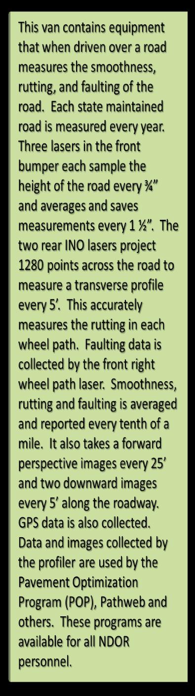
5 This book provides information to the Interstate Task Force and others working on interstate projects. It provides historical and current rating data, maps, future and past construction projects, description of the location, current surfacing, and other information. A supplemental report is included that contains graphs of the latest rutting and fault depths measured on the interstate for each tenth of a mile.

6 The original DEH file structure was developed by Navstar Mapping Corporation for evaluating and reporting vertical and horizontal curve data. The DEH Creator is a VB utility program created by the Roadway Asset Management Section of the M&R Division. This software is used to create the DEH Distance Elevation Heading file format. The main function of DEH Creator is to translate vector data from other sources into the DEH file format. This translator does more than simply copy data to a new form. The raw data is first analyzed for quality, flagged for repair and then regenerated if needed. For example, if a section of road is missing a series of elevation points, the software repairs the data by extrapolating elevation points using the present of grade calculations before and after the missing segment. In this way the DEH Creator software is capable of repairing errors by creating new data when there were omissions in a data string. The VCL program (Vertical Curve Locator) is a VB utility program created by the Roadway Asset Management Section of M&R Division. This software utilizes information obtained from as built construction plans for input in the form of stations with percent of grade. It then outputs vertical curve data in the form of crest log mile with a minimum safe sopping sight distance. It can be setup to run calculations for both standard and metric plan information. The user interface is as simple as a common math calculator to speed data entry. However, it is capable of storing the calculated information for populating a table within the IHI mainframe system.

7 The Rating Database, using a Microsoft Access platform, has been enhanced with input forms and VB software created by the Roadway Asset Management Section of the M&R Division. This database is used to log the individual road distresses of hard surface roads to find the overall condition of roads for the departments needs studies. There are many enhancements that are used to assure quality data collection and eliminate potential errors. Quick data retrieval for a given mile point aids in the fast data collection. The color flagging of potential data issues visuals shows key punch errors. When data is entered that does not conform to certain rating rules, the colors green, yellow, and red are used to indicate the severity of the rating rule violations. This tool helps to insure roads are rated accurately and efficiently.

8 The HPMS is submitted to the FHWA annually by the unit. This is a source of information used by FHWA to analyze the nation s highway system condition, performance and investment needs that are reported to congress in the biennial Condition and Performance Report. Information is also published in FHWA s annual Highway Statistics report.

9 The Roadway Data Mgt / Classification & Needs Unit is responsible for the collection and management of geometric, classification, and location information on the over 96,000 miles of highways, county roads, and city streets in Nebraska. Inventory personnel examine roads to gather the GPS information, roadway length, geometrics, and culture information. Information supplied by the inventory personnel along with information gathered from roadway construction plans and information from local officials is analyzed by the statistics personnel. This information is then used to populate tables in the Integrated Highway Inventory System (IHI) on the mainframe.

10

11
12

13


14
15

16 MADDOG (Menu Aided Display of Digital Maps or GIS Products) is a tool originally created for the Director s office to allow them access to a wide variety of maps without requiring them to know where the files are located or how to use the software. MADDOG provides access to NDOR microstation users to Functional Classification, County, City, District maps as well as maps with bridge locations, maps with railroad crossings, Program maps, Maintenance Yard maps, the Railroad map, Traffic Flow Map and many others.

17 The GIS/Mapping Unit maintains GIS layers of the current Highway Network including ramps, Major and Minor Collector Routes, City Corporate Limit Boundaries, Airport Boundaries, and Maintenance Yard Locations. The unit also maintains a set of all 93 county maps and 530 city plats. We rely on County Highway Superintendants and Roadway Data Management personnel to provide local road and feature updates. We constantly receive calls for specialty maps. A couple examples are requests from emergency management for reference posts along highways, Tourism maps featuring scenic byways, State Patrol Troop areas, and requests from UPS for area maps of counties merged together. The GIS/Mapping Unit maintains maps for other divisions such as the Traffic Flow map, the Speed Limit Map, the Railroad Map, the Bicycle Map, the Program Maps. Our unit is responsible for the State Tourist Map. We have scanned past State Tourist Maps and many historic maps.

18 This program is a one-stop-shop for Highway related data. It allows you to investigate your current pavement ratings, create a map of the section, create a cross section diagram, link to our log book, link to the bridge information system and to the Pathweb browser for viewing the roadway photos with GPS capabilities. It also has a life cycle cost analysis which prompts you to enter an analysis period and annual budgets. A yearly output report shows those selected sections that would be improved based on the budget and the benefit cost ratio. This is used to create the annual resurfacing candidate listings and the district budget allocations.


19 Find Feature Pathweb provides the user with the perspective views of the roadway every 25 feet as well as downward photos every 5 feet on an annual basis. Historical photos from the Mandli system are available from 1994 to There is also an option to turn on an IRI(roughness) graph and a transverse profile graph of the roadway The GIS mapping tool has options to show rutting or IRI with color coded ranges. Customized kml files can also be added to show data on the map. IRI Condition

20 Pavement Condition Assessment and Rehabilitation Effectiveness (PaveCARE) This program allows you to look at current pavement conditions and track the effectiveness of rehabilitation strategies. The Condition Assessment looks at the detailed rating data and gives you summarized graphs for distresses for either flexible or rigid pavement. The Rehabilitation Effectiveness tracks distresses and maintenance costs on seven preselected rehabilitation strategies. A trend line is graphed for the life of each strategy. These are the strategies being tracked: Concrete Construction(Non-Doweled) Concrete Construction(Doweled) Dowel Bar Retrofit Fly Ash Recycling Hot Lime Recycling SP5 Asphalt Thin Lift Overlays (< 2.5 in.) These resulting deteriorating rates for these strategies are then used in POP s life cycle cost analysis and the pavement management database.

21 Annual maps/repots are provided to the Districts to show the condition of their systems and also the candidates for improvements based on POP s life cycle cost analysis.
CHAPTER 2 PAVEMENT MANAGEMENT SYSTEM
 CHAPTER 2 PAVEMENT MANAGEMENT SYSTEM 2.1. INTRODUCTION TO PAVEMENT MANAGEMENT The ability of a pavement system to serve a society is largely a function of planning. Planning is the intersection between
SECTION III-06 Surfacing Page 1 Revised 3/2/10. See the DESIGN GUIDELINES in Section I-06 for requirements for cross slope of the roadway.
 Page 1 Revised 3/2/10 See the DESIGN GUIDELINES in Section I-06 for requirements for cross slope of the roadway. For New/Reconstruction projects: The cross slope of the driving lanes range from 1.5% to
Pavement Management System Overview
 TABLE OF CONTENTS The Home Screen... 3 The Gutter... 4 Icons... 4 Quick Links... 5 Miscellaneous... 6 PMS Menus... 7 Setup Menu... 7 Construction Setup... 7 1. Material Codes... 8 2. Standard Sections...
HERS_IN. HIGHWAY ECONOMIC REQUIREMENTS SYSTEM (for) INDIANA. AASHTO Transportation Estimator Association Conference October 16, 2001
 INDIANA. AASHTO Transportation Estimator Association Conference October 16, 2001") AASHTO Transportation Estimator Association Conference October 16, 2001 HERS_IN HIGHWAY ECONOMIC REQUIREMENTS SYSTEM (for) INDIANA OVERVIEW HERS Background System Planning Tool Development HERS_IN Structure
AASHTO Transportation Estimator Association Conference October 16, 2001 HERS_IN HIGHWAY ECONOMIC REQUIREMENTS SYSTEM (for) INDIANA OVERVIEW HERS Background System Planning Tool Development HERS_IN Structure
DRAFT MAINTAINING HOUSTON S STREETS REPAIR, REHABILITATION, RECONSTRUCTION. Using the Full Range of Tools for a Challenging Job
 MAINTAINING HOUSTON S STREETS REPAIR, REHABILITATION, RECONSTRUCTION Using the Full Range of Tools for a Challenging Job Report To: TTI Committee May 13, 2014 1 Pavement Management - Suggested Treatments
KENTUCKY TRANSPORTATION CABINET POLICY FOR FEDERALLY FUNDED PAVEMENT REHABILITATION AND PREVENTATIVE MAINTENANCE PROJECTS
 KENTUCKY TRANSPORTATION CABINET POLICY FOR FEDERALLY FUNDED PAVEMENT REHABILITATION AND PREVENTATIVE MAINTENANCE PROJECTS I. GENERAL The following policy shall apply when the intent of the project is to
CHAPTERS 600 670 PAVEMENT ENGINEERING CHAPTER 600 GENERAL ASPECTS
 HIGHWAY DESIGN MANUAL 600-1 May 7, 2012 CHAPTERS 600 670 PAVEMENT ENGINEERING CHAPTER 600 GENERAL ASPECTS Topic 601 - Introduction Pavement engineering involves the determination of the type and thickness
TAMS 2.1 User s Manual. Utah LTAP Center. Contact: Utah LTAP 4111 Old Main Hill Logan, UT. 84322-4111 800-822-8878 www.utahltap.
 TAMS 2.1 User s Manual Utah LTAP Center Contact: Utah LTAP 4111 Old Main Hill Logan, UT. 84322-4111 800-822-8878 www.utahltap.org Table of Contents Introduction 1 Initializing the program... 1 Data Needed
I-66 Pavement Rehabilitation
 I-66 Pavement Rehabilitation Fall Asphalt Conference Richmond, VA David Shiells, P.E. Virginia Department of Transportation David White Superior Paving Corporation October 2, 2012 Project Location 2 Goal
Rehabilitation Strategies for Bonded Concrete Overlays of Asphalt Pavements
 University of Pittsburgh Rehabilitation Strategies for Bonded Concrete Overlays of Asphalt Pavements Authors: J. M Vandenbossche S. Sachs August 2013 1. Introduction Bonded concrete overlays of asphalt
How To Manage Big Data For The Ohio Department Of Transportation
 Big Data & Asset Management Ohio Planning Conference 2014 John R. Kasich, Governor Jerry Wray, Director Ohio Department of Transportation Big Data: Asset Management Andrew Williams, Administrator Office
Road Asset Management
 Road Asset Management Raja Shekharan, Ph.D., P.E. Virginia Department of Transportation National Workshop on Modern Trends in Pavement Engineering IISc, Bangalore July 15, 2011 Transportation Asset Management
Pavement Management Implementation: Success Stories for Maryland Counties
 Pavement Management Implementation: Success Stories for Maryland Counties September 25, 2015 Aaron D. Gerber, P.E. How Does Your Organization Manage Pavement Assets? By Experience/Past Practice? By Customer
Visualizing Pavement Management Data at the Project Level
 Rydholm, Luhr 1 Visualizing Pavement Management Data at the Project Level Timothy C. Rydholm WSPMS Administrator Washington State Department of Transportation PO Box 47365 Olympia, WA 98504-7365 Phone:
Transportation Asset Management Program 2009 Federal Aid PASER Road Survey. August 2009
 Transportation Asset Management Program 2009 Federal Aid PASER Road Survey August 2009 WEST MICHIGAN SHORELINE REGIONAL DEVELOPMENT COMMISSION (WMSRDC) The WMSRDC is a regional council of governments representing
Transportation Infrastructure Asset Management
 2015 NW Region TTAP& BIA Symposium Transportation Infrastructure Asset Management March, 2015 Happy Longfellow, PE [email protected] (206) 394-3649 ASSET MANAGEMENT OVERVIEW What? Why? How? Inventory
EXPERIENCE WITH GEOGRAPHIC INFORMATION SYSTEMS (GIS) / MAPPING
 / MAPPING") EXPERIENCE WITH GEOGRAPHIC INFORMATION SYSTEMS (GIS) / MAPPING TEC has performed many GPS/GIS inventory projects and studies for the Ohio Department of Transportation (ODOT), Counties, and municipalities.
EXPERIENCE WITH GEOGRAPHIC INFORMATION SYSTEMS (GIS) / MAPPING TEC has performed many GPS/GIS inventory projects and studies for the Ohio Department of Transportation (ODOT), Counties, and municipalities.
CHAPTER 2 LCCA APPROACHES
 2.1 LCCA Basis CHAPTER 2 LCCA APPROACHES When making decisions about pavement design, LCCA: Compares pavement alternatives; and Identifies the best strategy based on current information as well as meeting
The State of Michigan Transportation Asset Management Council 2005 PASER Survey Of Genesee County
 The State of Michigan Transportation Asset Management Council 2005 PASER Survey Of Genesee County Prepared by the Genesee County Metropolitan Planning Commission Staff The State of Michigan Transportation
Types of Data. Features. Getting Started. Integrated Roadway Asset Management System
 3-2014 GIS-based Asset Management System Optimize Maintenance Manage Signs Analyze Safety Roadsoft is a roadway management system for collecting, storing, and analyzing data associated with transportation
CITY COUNCIL AGENDA ITEM CITY OF SHORELINE, WASHINGTON
 Council Meeting Date: August 11, 2014 Agenda Item: 7(c) CITY COUNCIL AGENDA ITEM CITY OF SHORELINE, WASHINGTON AGENDA TITLE: Motion Authorizing the City Manager to Execute a Contract with Transmap Corporation
CHAPTER 4 EXISTING TRANSPORTATION MANAGEMENT
 CHAPTER 4 EXISTING TRANSPORTATION MANAGEMENT TRANSPORTATION MANAGEMENT SYSTEMS Prior to 1991, the Missouri Department of Transportation (MoDOT) had begun development of several independent management systems.
Impacts of Increased Loading Due to Heavy Construction Traffic on Thin Pavements
 Impacts of Increased Loading Due to Heavy Construction Traffic on Thin Pavements Author: Harry Sturm, P. Eng. Stantec Consulting Ltd. 16-77 Mississauga Road Mississauga, ON L5N 7G2 Phone: (95) 817-296
GIS a Tool for Transportation Infrastructure Planning in Ghana A Case Study to the Department of Feeder Roads
 GIS a Tool for Transportation Infrastructure Planning in Ghana A Case Study to the Department of Stephen Yao FIATORNU, Ghana Key words: SUMMARY With the development of GIS technology, network transportation
Asset Management for MAP-21. Gary Lasham, P.E. Jonathan Pollack
 Asset Management for MAP-21 Gary Lasham, P.E. Jonathan Pollack Replaced Intermodal Surface Transportation Efficiency Act (ISTEA) MAP-21 is transforming the policy and programmatic framework for investments
Thin Whitetopping Application at Williamsburg Regional Airport and Other Thin Whitetopping Airport Applications.
 Thin Whitetopping Application at Williamsburg Regional Airport and Other Thin Whitetopping Airport Applications. Author: Gary L. Mitchell, P.E. Director Airports, American Concrete Pavement Association
Case Studies - Concrete Overlays
 Case Studies - Concrete Overlays Lessons Learned - Concrete Overlays Purdue Road School March 6, 2013 Today s Topic 1. Overlays 2. New Full-depth 3. Pervious 4. Roller Compacted 5. Full Depth Patching
Rehabilitation for Concrete Pavements
 Rehabilitation for Concrete Pavements www.asphaltalliance.com Overview Effective rehab for PCC Break PCC into small segments Overlay with Hot Mix Asphalt Road-userfriendly Rubblize and pave in off-peak
Pavement Management Program
 Pavement Management Program 2014 Street Maintenance Program Executive Summary 01/21/2014 Presented by Mark Thiel Assistant Director of Public Works Program Overview Start of current program 2005 825.1
SUPPLEMENTAL SPECIFICATIONS CROSS SLOPE VERIFICATION:
 September 22, 2009 Updated November 16, 2009 SUPPLEMENTAL SPECIFICATIONS CROSS SLOPE VERIFICATION: 1. DESCRIPTION: The cross slopes of the roadway are to be constructed as detailed in the plans and within
Chapter 7: Pavement Rehabilitation 7-1 Asphalt Pavement Overlays 7-1 Surface Preparation Methods 7-2 Concrete Pavement Preparation 7-3 Recycling
 7-1 Asphalt Pavement Overlays 7-1 Surface Preparation Methods 7-2 Concrete Pavement Preparation 7-3 Recycling Asphalt Pavements 7-7 Chapter 7 Pavement Rehabilitation Pavement rehabilitation can be accomplished
3.1 Historical Considerations
 3. Recommended Scope of Bridge improvements 3.1 Historical Considerations In the fall of 2000, an outside consultant, Fraser Design, suggested that the existing 4 th St. Bridge is potentially eligible
LIMITED SCOPE CONCEPT DEVELOPMENT REPORT
 LIMITED SCOPE CONCEPT DEVELOPMENT REPORT Route 33 Resurfacing Project Eastbound: Milepost 24.2 to Milepost 28.9 Westbound: Milepost 24.3 to Milepost 28.9 Manalapan & Freehold Townships, Monmouth County
Advancements in GPR for a Sustainable Tomorrow
 Advancements in GPR for a Sustainable Tomorrow Shawn Lapain, BSc. E., EIT Pavement Specialist Applied Research Associates Inc. 5401 Eglinton Avenue West, Suite 105, Toronto, ON, Canada, M9C 5K6 Tel: 416-621-9555,
Integrating GIS-Based Videolog and Asset Data With Commonly Used Systems Provides Major Benefits With Minimal Effort
 Integrating GIS-Based Videolog and Asset Data With Commonly Used Systems Provides Major Benefits With Minimal Effort Presented By: Debbie Burns, GIS Manager Michael Nieminen, Project Manager Introduction
Surface Transportation Program (STP) Projects
 Projects") Toledo Metropolitan Area Council of Governments American Reinvestment and Recovery Act (Economic Stimulus Program) Application Packet for: Surface Transportation Program (STP) Projects APPLICATIONS DUE
Toledo Metropolitan Area Council of Governments American Reinvestment and Recovery Act (Economic Stimulus Program) Application Packet for: Surface Transportation Program (STP) Projects APPLICATIONS DUE
Email: [email protected] Phone: + 64.9.87.7703 Fax: +64.9.87.7704. ROMDAS Manufactured by Data Collection Ltd. New Zealand
 For further information on the ROMDAS road measurement system please visit www.romdas.com Email: [email protected] Phone: + 64.9.87.7703 Fax: +64.9.87.7704 ROMDAS Manufactured by Data Collection Ltd. New
Chapter 22. Lump Sum Project Guidelines
 Chapter 22 Lump Sum Project Guidelines 22.1 General...22-1 22.2 Project Selection...22-3 22.3 Plans Preparation...22-5 22.4 Preliminary Estimate...22-7 22.5 Specifications...22-9 22.6 Contracts Administration...22-11
Pavement Management Systems
 Pavement Management Systems Presented by Bill Weiss, P.E. Applied Pavement Technology, Inc. (APTech) At the 2015 Municipal Streets Seminar Ames, Iowa Why Pavement Management??? Pavements are expensive
Monitoring Highway Assets with Remote Technology
 Monitoring Highway Assets with Remote Technology For the Michigan Department of Transportation July 2013 DYE MANAGEMENT GROUP, INC. Project Scope Summary of Technologies Aerial Imagery with LiDAR Mobile
Cornell Asset Management Program - Roads & Streets (CAMP-RS) 2014
 2014") Cornell Asset Management Program - Roads & Streets (CAMP-RS) 2014 Distributed by: Cornell Local Roads Program CLRP No. 14-01 Table of Contents 1 - Introduction to Cornell Asset Management Roads & Streets
Cornell Asset Management Program - Roads & Streets (CAMP-RS) 2014 Distributed by: Cornell Local Roads Program CLRP No. 14-01 Table of Contents 1 - Introduction to Cornell Asset Management Roads & Streets
CHAPTER 20. GEOPAK Road > 3D Tools > 3D Modeling
 CHAPTER 20 3D Modeling 20.1 Introduction Objectives Project Manager - Create 3D cross sections from 2D cross sections - Interpolate between 3D cross sections to create B-spline surfaces. - Use Drive Through
Minimizing Reflective Cracking With Applications of the Rolling Dynamic Deflectometer and Overlay Tester
 Minimizing Reflective Cracking With Applications of the Rolling Dynamic Deflectometer and Overlay Tester Dar-Hao Chen, 1 Moon Won, 2 Tom Scullion, 3 and John Bilyeu 4 ABSTRACT Since reflective cracking
ADA POST INSPECTION CHECKLIST. Job No. Route County Location
 ADA POST INSPECTION CHECKLIST Job No. Route County Location SIDEWALKS All sidewalks constructed within the project limits are ADA compliant. Sidewalks are 5 or greater in width. Exception, existing sidewalks
Presentation to NYSAMPO, June 2015 Steve Wilcox, P.E., Director, Maintenance Program Planning Bureau NYSDOT
 Presentation to NYSAMPO, June 2015 Steve Wilcox, P.E., Director, Maintenance Program Planning Bureau NYSDOT Comprehensive Asset Management Planning What Is Your Asset Management Organization? What Do You
LIFE-CYCLE COST ANALYSIS PROCEDURES MANUAL
 LIFE-CYCLE COST ANALYSIS PROCEDURES MANUAL State of California Department of Transportation Division of Maintenance Pavement Program LCCA Procedures Manual August 213 DISCLAIMER This manual is intended
MODULE 3. Upon completion of this module the participants will be able to:
 MODULE 3 PAVEMENT MANAGEMENT SYSTEMS OVERVIEW 2.1 Module Objective This module describes the basic components of a Pavement Management System, as well as provides some historical perspective on the evolution
Date: 10/10/2014 Initiated by: AAS-100
 U.S. Department of Transportation Federal Aviation Administration Advisory Circular Subject: Airport Pavement Management Program (PMP) Date: 10/10/2014 Initiated by: AAS-100 AC No: 150/5380-7B Change:
INDOT 2000-2025 Long Range Plan
 Chapter 9 INDOT 2000-2025 Long Range Plan Highway Needs Analysis Overview The statewide transportation planning process provides for the identification of highway needs through a comprehensive process
700 Life-Cycle Cost Analysis... 700-1
 Table of Contents 700 Life-Cycle Cost Analysis... 700-1 701 Introduction... 700-1 701.1 Discount Rate... 700-1 702 Initial Construction... 700-1 703 Future Rehabilitation... 700-1 703.1 Introduction...
CONCRETE REPAIR GUIDELINES. Concrete repairs can be broken down into four basic types, plus special repairs and planing.
 CONCRETE REPAIR GUIDELINES Concrete repairs can be broken down into four basic types, plus special repairs and planing. Note: It is recommended that investigation into soundness of pavement be performed
Planning Level Cost Estimation Tool. User s Manual
 Planning Level Cost Estimation Tool User s Manual Atlanta Regional Commission Submitted By: User s Manual Table of Contents 1. INTRODUCTION... 1 2. OBJECTIVE... 1 3. FRAMEWORK OF THE TOOL... 2 4. HOW TO
The Indiana Experience
 Transportation Asset Management Case Studies Presented by HIGHWAY ECONOMIC REQUIREMENTS SYSTEM-STATE The Indiana Experience Aerial view of the I-65/I-75 split in Indianapolis. Photo by James Kinder. FRONT
Evaluation of Long-Lasting Perpetual Asphalt Pavement Using Life-Cycle Cost Analysis. Arnar Agustsson Sulton Azamov
 Evaluation of Long-Lasting Perpetual Asphalt Pavement Using Life-Cycle Cost Analysis Arnar Agustsson Sulton Azamov Contents 1. Perpetual Asphalt Pavement 2. Scope 3. Methodology 4. Performance 5. Alternatives
TAC Primer Pavement Asset Design and Management
 Transportation Association of Canada TAC Primer Pavement Asset Design and Management Introduction Transportation infrastructure plays an important role in the social and economic development of a country,
Guide to the Texas A&M Transportation Institute Mobile Retroreflectometer Certification Program
 Guide to the Texas A&M Transportation Institute Mobile Retroreflectometer Certification Program Program Conducted by Texas A&M Transportation Institute In Cooperation with the Texas Department of Transportation
Intergraph Roadway Information Management Solution. Title Title. Title Title. A White Paper
 Intergraph Roadway Information Management Solution A White Paper Security, Government & Infrastructure, a division of Intergraph Title Title Title Title Table of Contents 1. Introduction... 1 2. Intergraph
RoadMatrix V3.1 has incorporated many engineering enhancements including the following:
 What s New in V3.1? RoadMatrix V3.1 has incorporated many engineering enhancements including the following: 1. Extended Programming Period The analysis programming period has increased from 10 to 100 years.
Project 0-4381: Develop an Automated System for Updating Pavement Layer Data
 0-4381-P2 BUSINESS ANALYSIS AND SOLUTIONS REPORT Authors: Zhanmin Zhang Pithon Vithayasricharoen Terry E. Dossey Project 0-4381: Develop an Automated System for Updating Pavement Layer Data JUNE 2004 Performing
In 2005, the City of Pasadena, CA, USA, with the support of consultants,
 Creating a Citywide Safe Routes to School Program: Pasadena, CA, USA s Step-by-Step Approach In 2005, the City of Pasadena, CA, USA, initiated development of a comprehensive Safe Routes to School Program.
Infrastructure assets are distinguished from other capital assets because they normally:
 4. REPORTING 4.2 Government-Wide Financial Statements 4.2.6 Infrastructure Reporting 4.2.6.10 Governments are required to report all of their capital assets in the statement of net position. Infrastructure
Pavement Maintenance M A N U A L. Mike Johanns Governor. John Craig Director
 Pavement Maintenance M A N U A L Mike Johanns Governor John Craig Director Pavement Maintenance Manual Acknowledgements........................................................................ii Introduction..............................................................................1
Reformulated Pavement Remaining Service Life Framework
 Reformulated Pavement Remaining Service Life Framework Publication No. FHWA-HRT-13-038 november 2013 Research, Development, and Technology Turner-Fairbank Highway Research Center 6300 Georgetown Pike McLean,
Safety Engineering Policy Memorandum
 Safety Engineering Policy Memorandum SAFETY 2-13 Automated Traffic Law Enforcement Systems: Red Light Running (RLR) Camera Enforcement Systems and Automated Railroad Grade Crossing (RGC) Enforcement Systems
Pavement Rehabilitation Selection Rehabilitation Techniques
 Pavement Rehabilitation Selection Rehabilitation Techniques Bituminous Pavement Rehabilitation Techniques Overlays Bituminous Concrete Pre-overlay Treatments Mill and Overlay Mill and Inlay Recycling Options
Managing the Risk of Aging Pavement Infrastructure in New Brunswick Through Innovative Decision Making
 Managing the Risk of Aging Pavement Infrastructure in New Brunswick Through Innovative Decision Making Jay Cunningham, MSc.Eng., P.Eng. New Brunswick Department of Transportation John MacNaughton, BSc.
Alternatives Presentation Meeting Middlebury WCRS(23)
") Alternatives Presentation Meeting Middlebury WCRS(23) Main Street (VT 30/TH 2 Bridge 102) and Merchants Row (TH 8 Bridge 2) over Vermont Railway June 4, 2013 Twilight Hall Auditorium, Middlebury College
Alternatives Presentation Meeting Middlebury WCRS(23) Main Street (VT 30/TH 2 Bridge 102) and Merchants Row (TH 8 Bridge 2) over Vermont Railway June 4, 2013 Twilight Hall Auditorium, Middlebury College
CHAPTER 4 SURFACE TRANSPORTATION PROGRAM (STP)
") Local Assistance Program Guidelines Chapter 4 CHAPTER 4 SURFACE TRANSPORTATION PROGRAM (STP) CONTENTS Section Subject Page Number 4.1 INTRODUCTION... 4-1 4.2 ELIGIBILITY CRITERIA... 4-1 General... 4-1
Local Assistance Program Guidelines Chapter 4 CHAPTER 4 SURFACE TRANSPORTATION PROGRAM (STP) CONTENTS Section Subject Page Number 4.1 INTRODUCTION... 4-1 4.2 ELIGIBILITY CRITERIA... 4-1 General... 4-1
14-97. 14-97.002 Definitions. For the purposes of this rule chapter the following definitions shall apply unless the context clearly shows otherwise:
 14-97 14-97.001 Purpose. This rule chapter sets forth an access control classification system and access management standards to implement the State Highway System Access Management Act of 1988. The implementation
Township of Enniskillen. Asset Management Plan
 Township of Enniskillen Asset Management Plan 2014 1 TABLE OF CONTENTS Page A. Introduction 3 B. State of Local Infrastructure 4 C. Desired Levels of Service 7 D. Asset Management Strategy 8 E. Financing
Road Rehabilitation and Reconstruction Using AutoCAD Civil 3D
 Road Rehabilitation and Reconstruction Using AutoCAD Civil 3D Contents Introduction... 3 Introduction to Corridor Targets... 3 Surface Targets... 4 Width and Offset Targets... 5 Elevation or Slope Targets...
GENERAL. This manual addresses five local programs that are funded under the current Highway Act:
 OVERVIEW The Local Public Agency Manual published by the Missouri Department of Transportation (MoDOT) is intended to be used as a guide for cities and counties that sponsor projects utilizing federal
Pavement Management Office
 Department of Transportation and Public Works Puerto Rico Pavement Management Office PAVEMENT PRESERVATION SEPPP 1 GOALS AND OBJECTIVES PRHTA has been collecting data for more than twenty (20) years with
Portland Cement Concrete Pavement Best Practices Summary Report
 Portland Cement Concrete Pavement Best Practices Summary Report WA-RD 744.1 Stephen T. Muench August 2010 Office of Research & Library Services WSDOT Research Report Research Report Agreement T2695, Task
LIFE-CYCLE COST ANALYSIS PROCEDURES MANUAL
 LIFE-CYCLE COST ANALYSIS PROCEDURES MANUAL Note to the User To use this manual, the reader must have the life-cycle cost analysis software program RealCost, Version 2.2 California Edition. The program
Sign Inventory and Management (SIM) Program Introduction
 Program Introduction") Sign Inventory and Management (SIM) Program Introduction A Sign Inventory and Management (SIM) Program is an area of asset management that focuses specifically on creating an inventory of traffic signs
Sign Inventory and Management (SIM) Program Introduction A Sign Inventory and Management (SIM) Program is an area of asset management that focuses specifically on creating an inventory of traffic signs
How To Improve Safety
 Collision Diagrams Collision diagrams are used to display and identify similar accident patterns. They provide information on the type and number of accidents; including conditions such as time of day,
3 Tappan Zee Bridge Rehabilitation Options
 3 Tappan Zee Bridge Rehabilitation Options 3.1 Introduction This chapter describes possible options that rehabilitate and enhance the existing Tappan Zee Bridge. Four Rehabilitation Options have been developed:
INDIANA DEPARTMENT OF TRANSPORTATION BRIDGE INSPECTION PROGRAM CODING GUIDE
 INDIANA DEPARTMENT OF TRANSPORTATION BRIDGE INSPECTION PROGRAM CODING GUIDE BRAGI Bridge Reporting for Appraisal & Greater Inventory Volume III: Other INDOT Items November 2011 Item Number Item Name BRAGI
Reports are a method of taking data stored in the various InRoads files and presenting it in a readable format.
 Reports are a method of taking data stored in the various InRoads files and presenting it in a readable format. Chapter Objectives: To describe where the data used to generate reports is stored. To present
Eric Ross Federal Highway Administration Proposed Office of Performance Management
 Life-Cycle Cost Analysis a Decision Making Tool Eric Ross Federal Highway Administration Proposed Office of Performance Management FHWA Tools Team Evaluation and Economic Investment Team development and