Groundwater exploration WATEX applications with Ground Penetrating Radars. Dr.Saud Amer USGS Dr.Alain Gachet Radar Technologies France
|
|
|
- Morris Lindsey
- 8 years ago
- Views:
Transcription
1 Groundwater exploration WATEX applications with Ground Penetrating Radars Dr.Saud Amer USGS Dr.Alain Gachet Radar Technologies France

2 GPR is a technology that allows rapid and non destructive collection of data. -The result is a 3-D database of the underground geology and hydrology (from surface to 40 meters deep) according to the kind of antenna in use. -It can easily be compared to seismic lines using acoustic waves, with one major difference : -GPR provides an echography using electromagnetic waves (microwaves).

3 The 400 Mhz antenna has a penetration depth from surface down to 5 meters. -It can be used for soil surveys and fractures mapping -The profiles can be acquired out of tracks. -All data recorded in 16 bits -Range 88 ns -10 impulsions per meter, whatever the acquisition speed, imply a spatial resolution of 10 cm Antenna must be kept in contact with soil

4 The 400 Mhz antenna trailed by a chain behind a car and the profiles are recorded continuously with 10 impulses per meter

5 The 400 Mhz GPR program of 10 lines averaging 4 km each has been achieved on pre-recorded targets over WATEX images

6 The 400 Mhz GPR used in tough terrane conditions

7 GPR echographies confirm soil detection by remote sensing. They detect thickness and structure over the first 5 meters along hundreds of kilometers.

8 Ground truthing with an excavator : Discovery in Oman of hectares of new soils in 8 days only

9 The 40 Mhz antenna has a penetration depth from surface down to 40 meters. -It can be used for Geologic surveys and fractures mapping -The profiles can be acquired out of tracks. -All data recorded in 16 bits -10 to 60 impulsions per seconds, No contact needed between antenna and soil, can be operated by helicopter or by car.

10 40 Mhz GPR trailed behind car is Sudan

11 Fractures detected by 40 Mhz GPR with 50 cm accuracy Surface F F F Metamorphic dry basement F F 25 m

12 Why is this hand pump dry?

13 GPR radargram showing dry alluvial deposits overlying granitic basement in Kordofan-Sudan 30 m 0 m Dry alluvial deposits Dry granitic basement

14 Why is this Mahogany forest dying?

15 Mahogany trunks infected by termites?

16 Immediate answer after trailing the 40 Mhz GPR antenna through the mahogany plantation

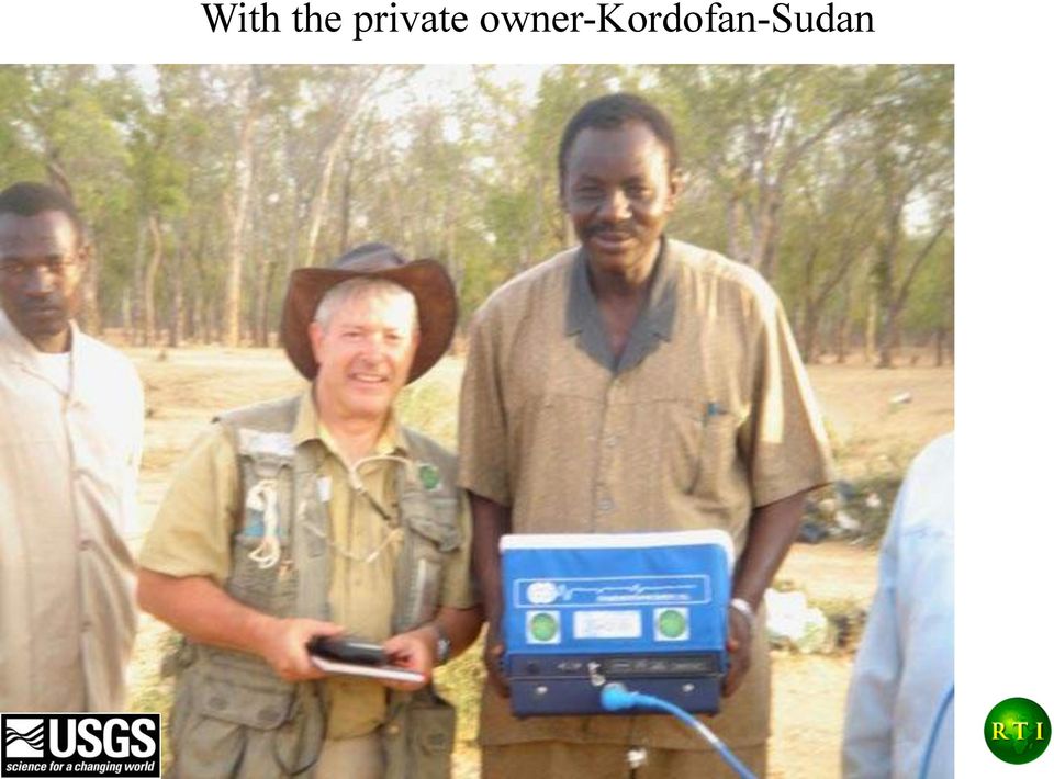
17 With the private owner-kordofan-sudan
18 30 m Inclined granitic basement overlaid by dry sediments : drought is harming the trees (vegetative stress after severe years of drought) 0 m Dry alluvial deposits Dry granitic basement
 0 m Dry alluvial deposits Dry")
19 Perched aquifers over granitic basement : Mahogany trees above this area are not affected by termites 30 m 0 m Alluvial deposits Perched aquifers Dry granitic basement

20 The Ground Penetrating Radar or GPR is a light accurate and quick geophysic instrumentation which can be used anywhere in dry conditions 40 Mhz antenna penetrating down to 40 m. Light equipment of 5 kg can be carried anywhere

21 GPR standard processing sequences 1-Vertical shift to zero 2-Velocity analysis 3-Filtering to erase multiples 4-Gain adaptation and enhancement.
22 1-Vertical shift to zero During acquisition, all radargrams are recorded with a shift in order to better delineate the first echo. The shift is then computed by analysing the maximum signal amplitude as shown below.
23 1-Vertical shift to zero During acquisition, all radargrams are recorded with a shift in order to better delineate the first echo. The shift is then computed by analysing the maximum signal amplitude as shown below. Radargram before shift to 0 Radargram after shift to 0
24 2-Velocity analysis Velocity analysis is achieved by using some hyperboles appearing on the radargrams.using the Kirchhoff migration process, we adapt directly on the screen the size of the hyperbole (whitish cone) to the real one on the radargram.. This gives immediately, on the left screen, the velocity in Meters per nanosecond. Obviously, m/ns is not matching the morphology of the radargram hyperbole. First essay : Radar processing window with velocity of m per nano-second
25 Second essay with velocity of m per nano-second. This velocity of m/ns is better matching the hyperbole shape 2-Velocity analysis The radar waves velocity in the soil, V is dependant of the coefficient ε called dielectric coefficient of the soil (or soil dielectric impedance) and C, the light velocity, according to the formula : V = C/ ε. When applying this formula, = 0.3/ ε we extract the value of ε value = 7 which is generally matching the value of superficial layers all over the survey area in the desert of Oman. This value has been used to convert all data from time to depth on all radargrams.
26 3-Filtering to erase multiples Radar filter window applied to line 29 which shows pseudo-horizontal layers before filter application.
27 3-Filtering to erase multiples 4-Gain adaptation and enhancement Alluvium-detritic progradations Alluvium-detritic progradations Limestones Limestones After the enhanced linear adaptative gain and removing the multiples, we have improved the detailed vision of line 29 showing alluvium progradations or infillings of the southern flanks of Wadi Tharawt along the dipping limestone layer.
28 We can test deep seated major fractures without ambiguity from the first 3 meters with deeper consequences for groundwater circulation Major fracture within Wadi Tharawt on line 3bis with 1,20 meter thrust
29 Sustainable development will result from the discovery of groundwater and new soils. with new radar technologies operated continuously from Space to the field. Such a work can be undertaken anywhere.
Ground Penetrating Radar Survey of a Portion of the Riverside Cemetery, Hopkinsville, Kentucky
 Ground Penetrating Radar Survey of a Portion of the Riverside Cemetery, Hopkinsville, Kentucky October 2012 Report prepared by Anthony L. Ortmann, Ph.D. Assistant Professor Department of Geosciences Murray
DETECTION OF WATER LEAKS USING GROUND PENETRATING RADAR
 DETECTION OF WATER LEAKS USING GROUND PENETRATING RADAR Sami Eyuboglu, Hanan Mahdi, and Haydar Al-Shukri Department of Applied Science University of Arkansas at Little Rock Little Rock, AR, 72204, USA
SUBSURFACE INVESTIGATION USING GROUND PENETRATING RADAR
 SUBSURFACE INVESTIGATION USING GROUND PENETRATING RADAR Steve Cardimona Department of Geology and Geophysics, University of Missouri-Rolla, Rolla, MO ABSTRACT The ground penetrating radar geophysical method
Stop Treating Diffractions as Noise Use them for Imaging of Fractures and Karst*
 Stop Treating Diffractions as Noise Use them for Imaging of Fractures and Karst* Mark Grasmueck 1, Tijmen Jan Moser 2, and Michael A. Pelissier 3 Search and Discovery Article #120057 (2012) Posted December
2. THE TEORRETICAL OF GROUND PENETRATING RADAR:
 Sixteenth International Water Technology Conference, IWTC 16 2012, Istanbul, Turkey 1 THE USE OF GROUND PENETRATING RADAR WITH A FREQUENCY 1GHZ TO DETECT WATER LEAKS FROM PIPELINES Alaa Ezzat Hasan Ministry
Moultrie Group Subsurface Geophysical Surveys
 Moultrie Group Subsurface Geophysical Surveys Martin Brook Moultrie Geology, Banyo, Brisbane, QLD 04 37887 362 mbrook@moultrie.com.au Subsurface Geophysical Surveys Martin Brook / Senior Project Geologist
POTENTIAL AND LIMITATIONS OF THE ARCHAEO-GEOPHYSICAL TECHNIQUES
 Geoarchaeology and Archaeomineralogy (Eds. R. I. Kostov, B. Gaydarska, M. Gurova). 2008. Proceedings of the International Conference, 29-30 October 2008 Sofia, Publishing House St. Ivan Rilski, Sofia,
COBRA WiFi. 2 CHANNEL GPR Detect both shallow and deep pipes
 COBRA WiFi 2 CHANNEL GPR Detect both shallow and deep pipes WiFi operation no cables needed Dual Channel GPR, 250/500 MHz Complete GPR-system all inclusive Included Post Processing Software GPS Path Finder
Matt Harris, Golder Associates (NZ) Ltd. The value of geophysics as a non-intrusive method for site characterisation
 Ltd. The value of geophysics as a non-intrusive method for site characterisation") Matt Harris, Golder Associates (NZ) Ltd. The value of geophysics as a non-intrusive method for site characterisation Presentation Outline What is geophysics and how can it help me? Electrical Resistivity
Matt Harris, Golder Associates (NZ) Ltd. The value of geophysics as a non-intrusive method for site characterisation Presentation Outline What is geophysics and how can it help me? Electrical Resistivity
MONITORING THE GPR RESPONSE OF CURING CONCRETE T. De Souza 1, A.P. Annan 1, J.D. Redman 1, and N. Hu 1 1 Sensors & Software Inc., Mississauga, Canada
 MONITORING THE GPR RESPONSE OF CURING CONCRETE T. De Souza 1, A.P. Annan 1, J.D. Redman 1, and N. Hu 1 1 Sensors & Software Inc., Mississauga, Canada Abstract: Ground penetrating radar (GPR) is becoming
TABLE OF CONTENTS FIGURES
 TABLE OF CONTENTS INTRODUCTION... 1 METHODS AND SURVEY DESIGN... 1 Ground Penetrating Radar Survey... 1 LiDAR Data Analysis... 2 RESULTS AND INTERPRETATIONS... 5 Geophysical Results... 5 CONCLUSIONS...
Figure 1: SITCRIM location. Thirteenth International Congress of the Brazilian Geophysical Society
 First Brazilian Federal Police Test Site for Forensic Geophysical Research BLUM, Marcelo de Lawrence Bassay, Departamento de Polícia Federal CAVALCANTI, Márcio Maciel, Universidade de Brasília RUSSO, Daniel,
Active and Passive Microwave Remote Sensing
 Active and Passive Microwave Remote Sensing Passive remote sensing system record EMR that was reflected (e.g., blue, green, red, and near IR) or emitted (e.g., thermal IR) from the surface of the Earth.
GROUND-PENETRATING RADAR SURVEY
 GROUND-PENETRATING RADAR SURVEY BANTEAY CHHMAR, CAMBODIA. For the Global Heritage Fund Till F. Sonnemann Archaeological Prospection Group, University of Sydney December 2009 EXECUTIVE SUMMARY Till Sonnemann
Satellite Altimetry Missions
 Satellite Altimetry Missions SINGAPORE SPACE SYMPOSIUM 30 TH SEPTEMBER 2015 AUTHORS: LUCA SIMONINI/ ERICK LANSARD/ JOSE M GONZALEZ www.thalesgroup.com Table of Content General Principles and Applications
This presentation reports on the progress made during the first year of the Mapping the Underworld project. As multiple Universities and Departments
 This presentation reports on the progress made during the first year of the Mapping the Underworld project. As multiple Universities and Departments are involved with the project, a single speaker will
GAS WELL/WATER WELL SUBSURFACE CONTAMINATION
 GAS WELL/WATER WELL SUBSURFACE CONTAMINATION Rick Railsback Professional Geoscientist CURA Environmental & Emergency Services rick@curaes.com And ye shall know the truth and the truth shall make you free.
GPR Polarization Simulation with 3D HO FDTD
 Progress In Electromagnetics Research Symposium Proceedings, Xi an, China, March 6, 00 999 GPR Polarization Simulation with 3D HO FDTD Jing Li, Zhao-Fa Zeng,, Ling Huang, and Fengshan Liu College of Geoexploration
APPLICATION OF THE GEO-EMR METHOD IN HYDROGEOPHYSICS
 NOVITOVI ALEKSANDAR 1, ŠESTAK ALEKSANDAR 1 APPLICATION OF THE GEO-EMR METHOD IN HYDROGEOPHYSICS During the recent decade, several new geophysical techniques have been introduced for mapping subsurface
A new direction-sensitive borehole logging tool for the spatial reconnaissance of geological structures
 A new direction-sensitive borehole logging tool for the spatial reconnaissance of geological structures D. Eisenburger, V. Gundelach Federal Institute for Geosciences and Natural Resources 30655 Hannover,
GPR detection of karst and archaeological targets below the historical centre of Merida, Yucatán, Mexico
 Studia Universitatis Babeş-Bolyai, Geologia, 2009, 54 (2), 27 31 GPR detection of karst and archaeological targets below the historical centre of Merida, Yucatán, Mexico Luis BARBA 1*, Jorge BLANCAS 1,
Full-Resolution GPR Imaging Applied to Utility Surveying: Insights from Multi-Polarization Data Obtained over a Test Pit
 Full-Resolution GPR Imaging Applied to Utility Surveying: Insights from Multi-Polarization Data Obtained over a Test Pit Roger Roberts, David Cist, and Andreas Kathage GSSI 12 Industrial Way, Salem, H,
GPR Antenna. Conduit. Also known as: Surface/Ground Probing Radar, Surface/Subsurface Penetrating Radar (SPR).
.") GPR Method N D E G R O U N D P E N E T R A T I N G R A D A R [ G P R] A PPLICATION The Ground Penetrating Radar (GPR) method is primarily applied to locate and measure the depth of steel reinforcement,
GPR Method N D E G R O U N D P E N E T R A T I N G R A D A R [ G P R] A PPLICATION The Ground Penetrating Radar (GPR) method is primarily applied to locate and measure the depth of steel reinforcement,
7.2.4 Seismic velocity, attenuation and rock properties
 7.2.4 Seismic velocity, attenuation and rock properties Rock properties that affect seismic velocity Porosity Lithification Pressure Fluid saturation Velocity in unconsolidated near surface soils (the
APPENDIX I WORLEYPARSONS GPR REPORT (ISSUED IN ELECTRONIC FORM)
") Angela MacPherson, TCPL July 27, 2011 Northwest Mainline Loop, Timberwolf Section Geotechnical Assessment Report Project: 0098-101-01-06 APPENDIX I WORLEYPARSONS GPR REPORT (ISSUED IN ELECTRONIC FORM)
Angela MacPherson, TCPL July 27, 2011 Northwest Mainline Loop, Timberwolf Section Geotechnical Assessment Report Project: 0098-101-01-06 APPENDIX I WORLEYPARSONS GPR REPORT (ISSUED IN ELECTRONIC FORM)
Thickness estimation of road pavement layers using Ground Penetrating Radar
 Dr. Eng. Audrey Van der Wielen Environment Concrete Roads Geotechnics & Surface Characteristics Division Belgian Road Research Centre (BRRC) a.vanderwielen@brrc.be Thickness estimation of road pavement
Imaging the earth using seismic diffractions
 Imaging the earth using seismic diffractions Rongfeng Zhang Abstract Diffractions in seismic data indicate discontinuities of the subsurface, although they are often obscured by and difficult to separate
A remote sensing instrument collects information about an object or phenomenon within the
 Satellite Remote Sensing GE 4150- Natural Hazards Some slides taken from Ann Maclean: Introduction to Digital Image Processing Remote Sensing the art, science, and technology of obtaining reliable information
TABLE OF CONTENTS PREFACE INTRODUCTION
 TABLE OF CONTENTS PREFACE The Seismic Method, 2 The Near-Surface, 4 The Scope of Engineering Seismology, 12 The Outline of This Book, 22 INTRODUCTION Chapter 1 SEISMIC WAVES 1.0 Introduction, 27 1.1 Body
Ground Penetrating Radar (GPR) Study Over Specific Medium
 Study Over Specific Medium") Ground Penetrating Radar (GPR) Study Over Specific Medium Marwan Lecturer, Geophysics Section, Department of Physics, Faculty of Sciences, Syiah Kuala University, Banda Aceh, Indonesia e-mail: marwan.fisika@gmail.com
Ground Penetrating Radar (GPR) Study Over Specific Medium Marwan Lecturer, Geophysics Section, Department of Physics, Faculty of Sciences, Syiah Kuala University, Banda Aceh, Indonesia e-mail: marwan.fisika@gmail.com
Chapter 3. Exploration Results at the Krang Kor Site
 Chapter 3. Exploration Results at the Krang Kor Site Akihiro Kaneda Center for Archaeological Operations Nara National Research Institute for Cultural Properties Introduction Using the research method
How To Monitor Sea Level With Satellite Radar
 Satellite Altimetry Wolfgang Bosch Deutsches Geodätisches Forschungsinstitut (DGFI), München email: bosch@dgfi.badw.de Objectives You shall recognize satellite altimetry as an operational remote sensing
Geophysical Survey at MIMA, The Bull Tavern Site Lexington, MA 2010. Draft
 Geophysical Survey at MIMA, The Bull Tavern Site Lexington, MA 2010. Draft By William A. Griswold, Ph.D., RPA Archeologist, National Park Service Northeast Region Archeology Program Heritage Preservation,
Basements and Deep Building Construction Policy 2014
 Basements and Deep Building Construction Policy 2014 APPROVAL Council / CEO 27 October 2014 VERSION NO: Version 1.0 TRIM REF: 14/67838 REVIEW 30/10/2019 RESPONSIBLE EXECUTIVE General Manager City Assets
How To Explore A Hot Spring
 Exploration Techniques The Geothermal Institute University of Auckland Bridget Lynne Santiago de Chile, 26-29 May 2014 Exploration Techniques Bridget Y. Lynne New techniques in geothermal exploration NZ
NuGeneration Ltd Site Investigations
 NuGeneration Ltd Site Investigations Introducing the site assessment and radiological characterisation project NuGen has commissioned an engineering consortium - which is a joint venture of IBERDROLA Ingeniería
INDIRECT METHODS SOUNDING OR PENETRATION TESTS. Dr. K. M. Kouzer, Associate Professor in Civil Engineering, GEC Kozhikode
 INDIRECT METHODS SOUNDING OR PENETRATION TESTS STANDARD PENETRATION TEST (SPT) Reference can be made to IS 2131 1981 for details on SPT. It is a field edtest to estimate e the penetration e resistance
Monitoring top soil moisture through remote sensing to aid hydrologic modelling
 Monitoring top soil moisture through remote sensing to aid hydrologic modelling N. Verhoest 1, H. Lievens 1, L. Hoffmann 2, P. Matgen 2, M. Montanari 2, M. Vanclooster 3, S. Lambot 3, J. Minet 3, B. De
WILLOCHRA BASIN GROUNDWATER STATUS REPORT 2009-10
 WILLOCHRA BASIN GROUNDWATER STATUS REPORT 2009-10 SUMMARY 2009-10 The Willochra Basin is situated in the southern Flinders Ranges in the Mid-North of South Australia, approximately 50 km east of Port Augusta
THE ULTRASONIC TOMOGRAPHY TESTS OF CONCRETE IN FOUNDATION SLAB
 THE ULTRASONIC TOMOGRAPHY TESTS OF CONCRETE IN FOUNDATION SLAB Krzysztof SCHABOWICZ 1, Jerzy HOLA 1, Dariusz STYS 1 1 Institute of Building Engineering, Wrocław University of Technology, Wybrzeże Wyspiańskiego
Radar Interferometric and Polarimetric Possibilities for Determining Sea Ice Thickness
 Radar Interferometric and Polarimetric Possibilities for Determining Sea Ice Thickness by Scott Hensley, Ben Holt, Sermsak Jaruwatanadilok, Jeff Steward, Shadi Oveisgharan Delwyn Moller, Jim Reis, Andy
ANNEX D1 BASIC CONSIDERATIONS FOR REVIEWING STUDIES IN THE DETAILED RISK ASSESSMENT FOR SAFETY
 ANNEX D1 BASIC CONSIDERATIONS FOR REVIEWING STUDIES IN THE DETAILED RISK ASSESSMENT FOR SAFETY ANNEX D1: BASIC CONSIDERATIONS FOR REVIEWING STUDIES IN DRA FOR SAFETY D1-1 ANNEX D1 BASIC CONSIDERATIONS
Presentation outline
 An Unified Approach of Non Destructive Testing and Evaluation on Building, Civil Engineering and Underground Utility Structures and Materials at HKIE (Buildings) Division (5 Sep 2013) Ir. Dr. Wallace W.L.
Ground Penetrating Radar (GPR): an application for evaluating the state of maintenance of the building coating
: an application for evaluating the state of maintenance of the building coating") ANNALS OF GEOPHYSICS, VOL. 46, N. 3, June 2003 Ground Penetrating Radar (GPR): an application for evaluating the state of maintenance of the building coating Giovanni Leucci, Sergio Negri and Maria Teresa
ANNALS OF GEOPHYSICS, VOL. 46, N. 3, June 2003 Ground Penetrating Radar (GPR): an application for evaluating the state of maintenance of the building coating Giovanni Leucci, Sergio Negri and Maria Teresa
SOUTHERN SIERRA CRITICAL ZONE OBSERVATORY - KREW PROJECT REQUEST FORM
 SOUTHERN SIERRA CRITICAL ZONE OBSERVATORY - KREW PROJECT REQUEST FORM Project Director/Principal Investigator (include contact information): Aniela Chamorro, PhD Student, Department of Geology & Geophysics,
CALCULATION OF TRANSVERSE RESISTANCE
 Lebanese Science Journal, Vol. 11, No. 1, 2010 105 CALCULATION OF TRANSVERSE RESISTANCE TO CORRECT AQUIFER RESISTIVITY OF GROUNDWATER SATURATED ZONES : IMPLICATIONS FOR ESTIMATING ITS HYDROGEOLOGICAL PROPERTIES
Simulating Aftershocks for an On Site Inspection (OSI) Exercise
 Exercise") LLNL-TR-677873 Simulating Aftershocks for an On Site Inspection (OSI) Exercise J. J. Sweeney, S. R. Ford October 5, 2015 Disclaimer This document was prepared as an account of work sponsored by an agency
LLNL-TR-677873 Simulating Aftershocks for an On Site Inspection (OSI) Exercise J. J. Sweeney, S. R. Ford October 5, 2015 Disclaimer This document was prepared as an account of work sponsored by an agency
Ground Penetrating Radar (GPR) Investigations at Fort Pulaski National Monument, Chatham County, Georgia. Prepared for:
 Investigations at Fort Pulaski National Monument, Chatham County, Georgia. Prepared for:") Ground Penetrating Radar (GPR) Investigations at Fort Pulaski National Monument, Chatham County, Georgia Prepared for: Fort Pulaski National Monument P.O. Box 30757 Savannah, GA 31410-0757 And: Southeast
Ground Penetrating Radar (GPR) Investigations at Fort Pulaski National Monument, Chatham County, Georgia Prepared for: Fort Pulaski National Monument P.O. Box 30757 Savannah, GA 31410-0757 And: Southeast
Cone penetration testing, CPTu
 1 Cone penetration testing, CPTu Preface Our company is Environmental Mechanics AB or short Envi. A Swedish company developing, producing and marketing systems for cone penetration testing (also known
NON-DESTRUCTIVE METHODS. CE 165: Concrete Materials and Concrete Construction
 NON-DESTRUCTIVE METHODS NON-DESTRUCTIVE METHODS Purpose: quick assessment of the structure Non-Destructive Techniques Many industrialized nations currently dedicate a considerable portion of the construction
High-resolution seismic reflection to image hydrogeologic sequences Richard D. Miller* and Jianghai Xia, Kansas Geological Survey
 Richard D. Miller* and Jianghai Xia, Kansas Geological Survey Introduction High-resolution seismic reflection has been successfully used to delineate preferential pathways within groundwater systems that
Introduction to Petroleum Geology and Geophysics
 GEO4210 Introduction to Petroleum Geology and Geophysics Geophysical Methods in Hydrocarbon Exploration About this part of the course Purpose: to give an overview of the basic geophysical methods used
PALEOENVIRONMENTS OF THE LAKE BALATON AREA
 Eötvös Loránd University Department of Geophysics HUNGARY 1117 Budapest Pázmány Péter sétány 1/C Tel: +36-1-3812191 Fax: +36-1-3812192 E-mail: geofizika@ludens.elte.hu PALEOENVIRONMENTS OF THE LAKE BALATON
Software tools for georadar data processing and visualization
 Software tools for georadar data processing and visualization Georgi Petrov New Bulgarian University Department Telecommunications Bulgaria, Sofia - 1618 Email: gpetrov@nbu.bg, http://www.nbu.bg Telephone:
Kenya water discovery brings hope for drought relief in rural no...
 September 11 2013 Last updated 1 minute ago gulfnews.com World Other World Stories Kenya water discovery brings hope for drought relief in rural north Two vast underground aquifers seen by satellite in
COMPENDIUM OF INDIAN STANDARDS ON SOIL ENGINEERING PART 2
 (PREVIEW) SP 36 (Part 2) : 1988 COMPENDIUM OF INDIAN STANDARDS ON SOIL ENGINEERING PART 2 IS 1893 : 1979 (Reaffirmed 1987) CODE OF PRACTICE FOR SUBSURFACE INVESTIGATION FOR FOUNDATIONS 1.1 This code deals
BRO: the Dutch Key Register of the Subsurface
 Fact sheet BRO: the Dutch Key Register of the Subsurface Data types explained January 2012 This BRO fact sheet, one of a series, is a publication of the Dutch Ministry of Infrastructure and the Environment.
Ground Penetrating Radar Fundamentals
 Ground Penetrating Radar Fundamentals by Jeffrey J. Daniels, Department of Geological Sciences, The Ohio State University Prepared as an appendix to a report to the U.S.EPA, Region V Nov. 25, 2000 Introduction
Lars-Göran Gustafsson, DHI Water and Environment, Box 3287, S-350 53 Växjö, Sweden
 Alternative Drainage Schemes for Reduction of Inflow/Infiltration - Prediction and Follow-Up of Effects with the Aid of an Integrated Sewer/Aquifer Model Introduction Lars-Göran Gustafsson, DHI Water and
Robot Perception Continued
 Robot Perception Continued 1 Visual Perception Visual Odometry Reconstruction Recognition CS 685 11 Range Sensing strategies Active range sensors Ultrasound Laser range sensor Slides adopted from Siegwart
New insights brought by broadband seismic data on the Brazil-Angola conjugate margins
 New insights brought by broadband seismic data on the Brazil-Angola conjugate margins Gregor Duval*, Jaswinder Mann, Lauren Houston and Steven Bowman Content Introductory remarks: why does the seismic
Benefits of high speed GPR to manage trackbed assets and renewal strategies
 Benefits of high speed GPR to manage trackbed assets and renewal strategies Asger Eriksen, Ben Venables, Jon Gascoyne & Shubho Bandyopadhyay Zetica Rail, Holdan House, 26 Bridge Street, Witney Oxon OX28
Data Transmission. Data Communications Model. CSE 3461 / 5461: Computer Networking & Internet Technologies. Presentation B
 CSE 3461 / 5461: Computer Networking & Internet Technologies Data Transmission Presentation B Kannan Srinivasan 08/30/2012 Data Communications Model Figure 1.2 Studying Assignment: 3.1-3.4, 4.1 Presentation
Important Points: Timing: Timing Evaluation Methodology Example Immediate First announcement of building damage
 3.3. Evaluation of Building Foundation Damage Basic Terminology: Damage: Destruction, deformation, inclination and settlement of a building foundation caused by an earthquake. Damage grade: Degree of danger
Letter Report Geophysical Subsurface Investigation Activities and Results Suspected Burial Site, Corpus Christi, Texas W.O. No. 02444.019.005.
 Weston Solutions, Inc. 2705 Bee Cave Road, Suite 100 Austin, Texas 78746 512-651-7100 Fax 512-651-7101 www.westonsolutions.com Mr. Omar Valdez Project Manager Texas Commission on Environmental Quality
Human Exposure Limits
 Human Exposure Limits Session 3 0 Version December 2014 Learning objectives In this session we will: Learn about the international exposure limits for workers and the public Learn about methods for assessing
manufacturer of seismic borehole equipment sales rentals field service
 manufacturer of seismic borehole equipment sales rentals field service the company Geotomographie provides complete solutions for borehole and near-surface seismic surveys to geophysical, engineering and
The successful integration of 3D seismic into the mining process: Practical examples from Bowen Basin underground coal mines
 Geophysics 165 Troy Peters The successful integration of 3D seismic into the mining process: Practical examples from Bowen Basin underground coal mines This paper discusses how mine staff from a number
Modelling the Discharge Rate and the Ground Settlement produced by the Tunnel Boring
 Modelling the Discharge Rate and the Ground Settlement produced by the Tunnel Boring Giona Preisig*, Antonio Dematteis, Riccardo Torri, Nathalie Monin, Ellen Milnes, Pierre Perrochet *Center for Hydrogeology
GPR Survey at the Archaeological Roman Site of Turaniana, Almeria, Spain
 International Journal of Pure and Applied Physics. ISSN 0973-1776 Volume 8, Number 2 (2012), pp. 99-111 Research India Publications http://www.ripublication.com/ijpap.htm GPR Survey at the Archaeological
Abstract. Introduction
 SEISMIC REFRACTION INTERPRETATION WITH VELOCITY GRADIENT AND DEPTH OF INVESTIGATION Michael L. Rucker AMEC Earth & Environmental, Inc. Phoenix, Arizona; michael.rucker@amec.com Abstract Traditional interpretation
hs2 Ground A non-technical guide
 hs2 Ground Investigations A non-technical guide Contents HS2 ground investigations 1 Essential Q&A 2 2 In-ground investigation techniques 9 2.1 Cable percussion borehole 10 2.2 Rotary core borehole 12
Training programme on flow measurements
 WMO / OMM Autorite du Bassin du Niger Niger-HYCOS and Volta-HYCOS Projects Training programme on flow measurements 2 nd part : Flow measurement techniques Flow measurements and calculations Definitions
Marine broadband seismic: Is the earth response helping the resolution revolution? N. Woodburn*, A. Hardwick, and R. Herring, TGS
 Marine broadband seismic: Is the earth response helping the resolution revolution? N. Woodburn*, A. Hardwick, and R. Herring, TGS Summary Broadband seismic aims to provide a greater richness of both (a),
EARTHQUAKES. Compressional Tensional Slip-strike
 Earthquakes-page 1 EARTHQUAKES Earthquakes occur along faults, planes of weakness in the crustal rocks. Although earthquakes can occur anywhere, they are most likely along crustal plate boundaries, such
Remote Sensing, GPS and GIS Technique to Produce a Bathymetric Map
 Remote Sensing, GPS and GIS Technique to Produce a Bathymetric Map Mark Schnur EES 5053 Remote Sensing Fall 2007 University of Texas at San Antonio, Department of Earth and Environmental Science, San Antonio,
Amplification of the Radiation from Two Collocated Cellular System Antennas by the Ground Wave of an AM Broadcast Station
 Amplification of the Radiation from Two Collocated Cellular System Antennas by the Ground Wave of an AM Broadcast Station Dr. Bill P. Curry EMSciTek Consulting Co., W101 McCarron Road Glen Ellyn, IL 60137,
RF Measurements Using a Modular Digitizer
 RF Measurements Using a Modular Digitizer Modern modular digitizers, like the Spectrum M4i series PCIe digitizers, offer greater bandwidth and higher resolution at any given bandwidth than ever before.
SINKHOLE DETECTION IN FLORIDA USING GPR AND CPT
 SINKHOLE DETECTION IN FLORIDA USING GPR AND CPT Paul J. Bullock 1 and Arthur Dillman 2 1 Asst. Prof., Civil and Coastal Engineering Dept., University of Florida P.O. Box 116580, Gainesville, FL 32611(pbull@ce.ufl.edu)
A comparative analysis of various seismic refraction interpretation techniques over granitic bedrock
 P-331 Summary A comparative analysis of various seismic refraction interpretation techniques over granitic bedrock Ankur Mundhra* 1, Om Prakash Pathak 1, Satyawrat Pamnani 1, T Sheshunarayana 2 A refraction
Monitoring a Changing Environment with Synthetic Aperture Radar. Alaska Satellite Facility National Park Service Don Atwood
 Monitoring a Changing Environment with Synthetic Aperture Radar Don Atwood Alaska Satellite Facility 1 Entering the SAR Age 2 SAR Satellites RADARSAT-1 Launched 1995 by CSA 5.6 cm (C-Band) HH Polarization
Soil degradation monitoring by active and passive remote-sensing means: examples with two degradation processes
 Soil degradation monitoring by active and passive remote-sensing means: examples with two degradation processes Naftaly Goldshleger, *Eyal Ben-Dor,* *Ido Livne,* U. Basson***, and R.Ben-Binyamin*Vladimir
Impact of water harvesting dam on the Wadi s morphology using digital elevation model Study case: Wadi Al-kanger, Sudan
 Impact of water harvesting dam on the Wadi s morphology using digital elevation model Study case: Wadi Al-kanger, Sudan H. S. M. Hilmi 1, M.Y. Mohamed 2, E. S. Ganawa 3 1 Faculty of agriculture, Alzaiem
How To Prepare A Geotechnical Study For A Trunk Sewer Project In Lincoln, Nebraska
 APPENDIX B Geotechnical Engineering Report GEOTECHNICAL ENGINEERING REPORT Preliminary Geotechnical Study Upper Southeast Salt Creek Sanitary Trunk Sewer Lincoln Wastewater System Lincoln, Nebraska PREPARED
< SUBSURFACE DAMS TO AUGMENT GROUNDWATER STORAGE IN BASEMENT TERRAIN FOR HUMAN SUBSISTENCE BRAZILIAN EXPERIENCE >
 CASE PROFILE COLLECTION No 5 < SUBSURFACE DAMS TO AUGMENT GROUNDWATER STORAGE IN BASEMENT TERRAIN FOR HUMAN SUBSISTENCE BRAZILIAN EXPERIENCE > Stephen Foster September 2002 TASK MANAGERS: Gabriel Azevedo
Laser Scanning Surveying and Ground Penetrating Radar The Full Three Dimensional Picture Above and Below Ground
 Laser Scanning Surveying and Ground Penetrating Radar The Full Three Dimensional Picture Above and Below Ground CIVILEX 2009 Mark Hudson, Director, Coastway, FInstCES MRICS MIS BTS Jeff Hott, Laser Scanning
Results of Archaeogeophysical Surveying at the Great Friends Meeting House in Newport, Rhode Island
 Results of Archaeogeophysical Surveying at the Great Friends Meeting House in Newport, Rhode Island Prepared for: Cultural and Historic Preservation Program Salve Regina University 100 Ochre Point Avenue
New York Science Journal, 2009, 2(3), ISSN 1554-0200 http://www.sciencepub.net/newyork, sciencepub@gmail.com
, ISSN 1554-0200 http://www.sciencepub.net/newyork, sciencepub@gmail.com") Electrical Method in Engineering and Environmental Studies: A Case Study of Gbagada Area, Lagos State, Nigeria. Oyedele, K.F and Ojo, A.O Dept of physics (Geophysics Programme) University of Lagos, Lagos
Electrical Method in Engineering and Environmental Studies: A Case Study of Gbagada Area, Lagos State, Nigeria. Oyedele, K.F and Ojo, A.O Dept of physics (Geophysics Programme) University of Lagos, Lagos
Create Your Own Soil Profile Ac5vity
 Create Your Own Soil Profile Ac5vity Middle School: 5-8 Task Overview: Soil profile refers to layers of soil. A typical soil profile takes nearly 1,000 to 100,000 years to form. The formation of the soil
EXPLAINING GROUNDWATER AND WATER WELLS
 EXPLAINING GROUNDWATER AND WATER WELLS This document aims to provide a non-technical description of groundwater: how it occurs, how it moves underground, and the basic principles behind constructing and
ources of Drinking Water
 The drop on water Sources of Drinking Water Did you know that 40 per cent of Nova Scotians get their water privately from a drilled well, a dug well, or a surface water source? The other 60 per cent rely
RFID applied to the built environment: Buried Asset Tagging and Tracking System
 RFID applied to the built environment: Buried Asset Tagging and Tracking System K. Dziadak, J. Sommerville & B. Kumar School of the Built and Natural Environment, Glasgow Caledonian University, Glasgow,
Securing the future of decom
 R E Q U I R E D R E A D I N G F O R T H E G L O B A L O I L & G A S I N D U S T R Y S I N C E 1 9 7 5 AUGUST 2011 Deep thinking on the Latin American beat Floating production tales of the unexpected OFFSHORE
Dip is the vertical angle perpendicular to strike between the imaginary horizontal plane and the inclined planar geological feature.
 Geological Visualization Tools and Structural Geology Geologists use several visualization tools to understand rock outcrop relationships, regional patterns and subsurface geology in 3D and 4D. Geological
Collecting and Analyzing Big Data for O&G Exploration and Production Applications October 15, 2013 G&G Technology Seminar
 Eldad Weiss Founder and Chairman Collecting and Analyzing Big Data for O&G Exploration and Production Applications October 15, 2013 G&G Technology Seminar About Paradigm 700+ 26 700+ 29 7 15,000+ 15+ 200M+
Towards Integral Groundwater Management in Arid Basins in China. Sino-Dutch Cooperation Project
 Towards Integral Groundwater Management in Arid Basins in China Sino-Dutch Cooperation Project Dick van Doorn & Sophie Vermooten, Deltares, Enabling Delta Life Sino-Dutch project: Capacity Building of
AirborneHydroMapping. New possibilities in bathymetric and topographic survey
 AirborneHydroMapping New possibilities in bathymetric and topographic survey AIRBORNE HYDROMAPPING (2008 2011) Layout needs from water engineering side: - Shallow water applications - High point density
Various Technics of Liquids and Solids Level Measurements. (Part 3)
") (Part 3) In part one of this series of articles, level measurement using a floating system was discusses and the instruments were recommended for each application. In the second part of these articles,
(Part 3) In part one of this series of articles, level measurement using a floating system was discusses and the instruments were recommended for each application. In the second part of these articles,
The dream for a better life has made man look for gold coins from the World War II (1940) which were lost in various parts of Greece.
 which were lost in various parts of Greece.") The search for gold and gold coins is one of the finest and the most widespread hobbies. It has its difficulties as well as its beautiful moments. The people involved in this hobby are commonly called
The search for gold and gold coins is one of the finest and the most widespread hobbies. It has its difficulties as well as its beautiful moments. The people involved in this hobby are commonly called
GLOSSARY OF TERMS CHAPTER 11 WORD DEFINITION SOURCE. Leopold
 CHAPTER 11 GLOSSARY OF TERMS Active Channel The channel that contains the discharge Leopold where channel maintenance is most effective, sediment are actively transported and deposited, and that are capable