Essential Question: How do location, climate, and natural resources affect people in Latin America?
|
|
|
- Ashlee Barrett
- 7 years ago
- Views:
Transcription

1 Essential Question: How do location, climate, and natural resources affect people in Latin America? SS6G3a. Compare how the location, climate, and natural resources of Mexico and Venezuela affect where people live and how they trade. SS6G3b. Compare how the location, climate, and natural resources of Brazil and Cuba affect where people live and how they trade.


2 Compare the location, climate, and natural resources of Mexico & Venezuela
3 Use your notes handout to record important information.
4 Comparing Mexico and Venezuela
5 Use your graphic organizer to record your information.
6

7 Mexico: Location & Climate Many types of landforms from plateaus to steep mountains to dense forests


8 Mexico: Location & Climate Northern and Central Mexico have a dry climate with little rainfall Southern Mexico has a humid, tropical climate
9 Mexico: Location & Climate Since most of its climate is dry with little rainfall, the majority of its land is unsuitable for farming Location makes it a great trading partner to the U.S. Mexico s oil reserves are also important for many countries
10 Mexico: Natural Resources Northern Mexico is rich with minerals like silver, copper, lead, iron, and oil

11 Mexico: Natural Resources Oil is the most valuable resource Most of the oil is found along the Gulf of Mexico coast
 in central Mexico to find jobs in")
12 Mexico: Where People Live Most live in cities (urban areas) in central Mexico to find jobs in factories
13 Mexico: Where People Live In areas rich with natural resources, such as Northern Mexico
14 Mexico: Where People Live In towns located close to the U.S. border to work in factories


15 Mexico: Where People Live Tourism is very important with resort towns such as Cancun and Acapulco
16 Write a sentence using location, climate, or natural resources that could convince someone to visit Mexico. When instructed, share your sentence with a partner.
17


18 Venezuela: Location & Climate Many types of landforms from mountains to grassy plains to tropical jungles


19 Venezuela: Location & Climate Hot and humid climate Distinct rainy Rainfall season

20 Venezuela: Location & Climate Location allows for trade with neighbors such as the U.S., Brazil, and Colombia U.S. provides food imports since agriculture is not strong in Venezuela

21 Venezuela: Natural Resources Oil is the most important natural resource Oil supports its economy and many Venezuelans work in the oil industry.


22 Venezuela: Where People Live Most live along the coast of the Caribbean Sea and in the nearby mountain valleys Most citizens live in cities (urban areas)
23 Write a sentence using location, climate, or natural resources that could convince someone to visit Venezuela. When instructed, share your sentence with a partner.
24 Fill in the comparison sections and the summarizing question.


25 Compare the location, climate, and natural resources of Brazil & Cuba
26 Use your notes handout to record important information.
27 Comparing Brazil and Cuba
28 Use your graphic organizer to record your information.
29 Brazil

30 Brazil: Location & Climate Most of the country has a low elevation Elevation

31 Brazil: Location & Climate Central area has the huge Amazon rain forest, which covers two-thirds of the country Brazil

32 Brazil: Location & Climate Warm, humid climate
33 Brazil: Location & Climate Location on the Atlantic Ocean allows it to ship products all over the world Its top trading partners are the U.S. and Argentina Argentina Brazil


34 Brazil: Natural Resources Climate allows the growth of crops such as sugarcane, coffee beans, and oranges in Southern Brazil It s the number one producer of coffee

35 Brazil: Natural Resources Iron ore has allowed Brazil to produce steel used to make vehicles and other goods for trade


36 Brazil: Where People Live Most live near the Atlantic coast Most live in cities (urban areas)

37 Brazil: Where People Live In the past the rain forest area was lightly populated, but in recent years the government has developed parts of the rain forest
38 Write a sentence using location, climate, or natural resources that could convince someone to visit Brazil. When instructed, share your sentence with a partner.
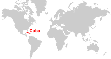
39
40 Cuba: Location & Climate Climate is semi-tropical, with warm, moderate temperatures Tropical Biome

41 Cuba: Location & Climate Most of the land is flat to rolling plains, with mountains covering part of the island. Elevation

42 Cuba: Natural Resources Cuba has rich soil which is good for growing sugarcane, coffee beans, tobacco, and other crops. Sugar is Cuba s most important product.

43 Cuba: Natural Resources
44 Cuba: Natural Resources Cuba trades heavily with Venezuela and China. Some of its exports are sugar, nickel, tobacco, and fish. We have not traded with Cuba for decades because the U.S. government put a ban on trade with Cuba because of its Communist government. - News clip discussing change in U.S./Cuba relations


45 Cuba: Where People Live Most Cubans live in cities and towns like the capital city of Havana where they might work in factories.

46 Cuba: Where People Live Those who live in rural areas may work on farms owned by Cuba s Communist government.
47 Write a sentence using location, climate, or natural resources that could convince someone to visit Cuba. When instructed, share your sentence with a partner.
48 Fill in the comparison sections and the summarizing question.
Chapter 18 Introduction to. A f r i c a
 Chapter 18 Introduction to A f r i c a Ch. 18:1 Landforms & Resources 1. Africa s shape & landforms are the result of its location in the southern part of the ancient supercontinent of. Pangaea Over thousands
Physiography, Geography and Climate of Latin America (Lecture 3)
") Physiography, Geography and Climate of Latin America (Lecture 3) Natural Landmarks in Latin America World's longest and second highest mountain range, and the world's highest active volcanoes. Biggest
Physiography, Geography and Climate of Latin America (Lecture 3) Natural Landmarks in Latin America World's longest and second highest mountain range, and the world's highest active volcanoes. Biggest
1. Incredible India. Shade the map on the next page, to show India s relief. The correct shading is shown on the final page! Incredible India India
 1. Incredible India Shade the map on the next page, to show India s relief. The correct shading is shown on the final page! Incredible India India The DCSF supported Action plan for Geography is delivered
SS6E1 The student will analyze different economic systems.
 Brazil & Cuba Standards SS6E1 The student will analyze different economic systems. a. Compare how traditional, command, and market, economies answer the economic questions of 1-what to produce, 2-how to
student. They should complete the
 Brazil & Cuba Standards SS6E1 The student will analyze different economic systems. a. Compare how traditional, command, and market, economies answer the economic questions of 1- what to produce, 2-how
TYPES OF ECONOMIC SYSTEMS Definition Key Terms Countries
 Cuba Brazil TYPES OF ECONOMIC SYSTEMS Definition Key Terms Countries 1) Market economy An economic system in which individuals own and operate the factors of production. 2) Command economy An economic
VISUAL 6.1 GREAT BRITAIN S AMERICAN COLONIES
 SPECIALIZATION AND TRADE IN THE THIRTEEN COLONIES LESSON 6 VISUAL 6.1 GREAT BRITAIN S AMERICAN COLONIES GREAT BRITAIN S COLONIES All colonies are rich in natural resources but short on labor. PRODUCTIVE
Regional Atlas: Introduction to South Asia
 Name Regional Atlas: Introduction to South Asia Study the map on page 593 of the textbook. 1. The Khyber Pass connects which two countries? CHAPTER 28 2. What capital city is located at 80 E longitude?
Geography affects climate.
 KEY CONCEPT Climate is a long-term weather pattern. BEFORE, you learned The Sun s energy heats Earth s surface unevenly The atmosphere s temperature changes with altitude Oceans affect wind flow NOW, you
CLIMATE, WATER & LIVING PATTERNS THINGS
 CLIMATE, WATER & LIVING PATTERNS NAME THE SIX MAJOR CLIMATE REGIONS DESCRIBE EACH CLIMATE REGION TELL THE FIVE FACTORS THAT AFFECT CLIMATE EXPLAIN HOW THOSE FACTORS AFFECT CLIMATE DESCRIBE HOW CLIMATES
Tropical Horticulture: Lecture 11
 Lecture 11 Agricultural Development in Tropical America Cuba Until 1900 the island was in an era of hacienda, only few plantations. A modern plantation developed at the end of the Colonial period. The
Climate, Vegetation, and Landforms
 Climate, Vegetation, and Landforms Definitions Climate is the average weather of a place over many years Geographers discuss five broad types of climates Moderate, dry, tropical, continental, polar Vegetation:
Ch.1. Name: Class: Date: Matching
 Name: Class: Date: Ch.1 Matching Match each item with the correct statement below. a. technology e. democracy b. diffusion f. extended family c. exports g. interdependence d. climate 1. goods sent to markets
III. BACKGROUND KNOWLEDGE
 Geography of South America Grade Level: Second Grade Presented by: Pamela Lee, Margaret Davenport, Hawthorne Elementary; Etta Kay Nickel, R. B. Green Elementary, San Antonio, TX Length of Unit: 7 lessons
The Regions of the United States
 CHAPTER 1 Identify characteristic landforms of the five major regions of the United States. Describe, compare, and contrast regional climates of the United States. Identify regional resources of the United
Answer Keys to Unit Tests
 Reading Geography Series Answer Keys to Unit Tests Unit 1 The Five Themes of Geography Unit 2 Patterns in Physical Geography Unit 3 Natural Resources 7 Portage & Main Press Unit Test for The Five Themes
6 th Grade Unit 5: Latin America Today
 The following instructional plan is part of a GaDOE collection of Unit Frameworks, Performance Tasks, examples of Student Work, and Teacher Commentary for the SIXTH GRADE Social Studies course. 6 th Grade
Impacts of Global Warming on North Carolina s Coastal Economy
 Impacts of Global Warming on North Carolina s Coastal Economy IMPACTS OF GLOBAL WARMING ON NORTH CAROLINA S COASTAL ECONOMY Key Findings Global warming is projected to have significant impacts on North
Tropical Rainforest. Abiotic Factors Amount of Water, Sunlight, Soil, Precipitation
 World Biomes A biome is an area of land that shares similar temperatures and precipitation. The observation of the temperature and precipitation over a period time make up a biome s climate. Each biome
CUBA CONFRONTING CLIMATE CHANGE
 CUBA CONFRONTING CLIMATE CHANGE CUBA: Main Characteristics Total population: 11.2 millions Length of the Island of Cuba: 1,200 Km. Maximum Width: 191 Km. Minimum Width: 31 Km. More than 4,000 islands and
NATURAL REGIONS OF KENTUCKY
 NATURAL WONDERS As you travel around Kentucky taking pictures, you are excited by what you see. Kentucky offers diverse and amazing sights. The Six Regions In the West, you see the Mississippi River, the
The concepts developed in this standard include the following: Oceans cover about 70% of the surface of the Earth.
 Name Date Grade 5 SOL 5.6 Review Oceans Made by SOLpass - www.solpass.org solpass100@comcast.net Reproduction is permitted for SOLpass subscribers only. The concepts developed in this standard include
SOUTH AMERICA CONTENTS. What s in This Book... 2. Section 1: South America in the World... 3. Section 2: Political Divisions of South America...
 SOUTH CONTENTS What s in This Book 2 Section 1: 3 Section 2: Political Divisions of 1 Section 3: Physical Features of 41 Section 4: Valuable Resources of 67 Section : n Culture 89 Section 6: Assessment
Grades 3-5. Benchmark A: Use map elements or coordinates to locate physical and human features of North America.
 Grades 3-5 Students use knowledge of geographic locations, patterns and processes to show the interrelationship between the physical environment and human activity, and to explain the interactions that
Witness an online magazine
 Witness an online magazine Cuba: An Island In Transition www.visionproject.org Photos & Text by Richard Falco Cuba: An Island In Transition Photos & Text by Richard Falco Cuba is quickly approaching a
not to be republished NCERT MAJOR LANDFORMS OF THE EARTH
 6 You must have seen some of the landform features as shown in the Figure 6.1 below. You will notice that the surface of the earth is not the same everywhere. The earth has an infinite variety of landforms.
2.6 RAINFALL MONITORING NETWORK IN THE AMAZONIAN JUNGLE
 2.6 RAINFALL MONITORING NETWORK IN THE AMAZONIAN JUNGLE Bernhard Lee Lindner* College of Charleston, Charleston SC Carlos Arturo Delvasto Fundacion Rio Bugalagrande, Tulua, Colombia 1. INTRODUCTION Our
Chapter 3 Communities, Biomes, and Ecosystems
 Communities, Biomes, and Ecosystems Section 1: Community Ecology Section 2: Terrestrial Biomes Section 3: Aquatic Ecosystems Click on a lesson name to select. 3.1 Community Ecology Communities A biological
CGC1D1: Interactions in the Physical Environment Factors that Affect Climate
 Name: Date: Day/Period: CGC1D1: Interactions in the Physical Environment Factors that Affect Climate Chapter 12 in the Making Connections textbook deals with Climate Connections. Use pages 127-144 to fill
Geography at GISSV: An Introduction to the Curriculum
 Geography at GISSV: An Introduction to the Curriculum Classes Geography is taught for two hours per week in Grades 5-9. The only exception is in Grade 8, where class is taught for one hour per week for
Prentice Hall World Studies: Latin America 2008 Correlated to: Missouri Social Studies Grade Level Expectations (Grade 7)
") Principles of Constitutional Democracy 1. Knowledge of the principles expressed in documents shaping constitutional democracy in the United States A. (1) Principles expressed in documents shaping constitutional
Principles of Constitutional Democracy 1. Knowledge of the principles expressed in documents shaping constitutional democracy in the United States A. (1) Principles expressed in documents shaping constitutional
Agricultural Reinsurance in Latin America Actual Situation & Outlook. 4 th Reinsurance Congress Rio de Janeiro (Brazil) April 2015
 April 2015") Agricultural Reinsurance in Latin America Actual Situation & Outlook 4 th Reinsurance Congress Rio de Janeiro (Brazil) April 2015 AGENDA Commodity Price & Food Consumption Context Worldwide Agriculture
Agricultural Reinsurance in Latin America Actual Situation & Outlook 4 th Reinsurance Congress Rio de Janeiro (Brazil) April 2015 AGENDA Commodity Price & Food Consumption Context Worldwide Agriculture
GENERAL INFORMATION. Area (km2) 406.752. Population 6.672.631 (2012) Ciudad del Este, Encarnación y Concepción. Other important cities
 406.752. Population 6.672.631 (2012) Ciudad del Este, Encarnación y Concepción. Other important cities") Paraguay GENERAL INFORMATION GENERAL INFORMATION Area (km2) 406.752 Oficial Languages Currency Spanish and Guarani Guaraní (Gs.) Population 6.672.631 (2012) GDP in US Millions Capital Other important cities
Paraguay GENERAL INFORMATION GENERAL INFORMATION Area (km2) 406.752 Oficial Languages Currency Spanish and Guarani Guaraní (Gs.) Population 6.672.631 (2012) GDP in US Millions Capital Other important cities
6 th Grade Vocabulary-ALL CAMPUSES
 6 th Grade Vocabulary-ALL CAMPUSES 6.1 History. The student understands that historical events influence contemporary events. (B) analyze the historical background of the United States to evaluate relationships
Chapter 3: Climate and Climate Change Answers
 Chapter 3: Climate and Climate Change Answers Section A: Climate 1. (a) Explain what each of the following means: (4 x 1 mark) (i) climate the average weather of an area over a 25 30 year period (ii) maritime
Rural developments in Latin America, 1930-2015. Michiel Baud CEDLA
 Rural developments in Latin America, 1930-2015 Michiel Baud CEDLA Export-orientation, 1870-1930 Expansion agrarian frontier Agrarian monocultures Replacement of traditional large landowners New forms of
Teacher s Masters California Education and the Environment Initiative. History-Social Science Standards 6.2.6. and 6.2.8. Egypt and Kush: A Tale of
 6 Teacher s Masters California Education and the Environment Initiative History-Social Science Standards 6.2.6. and 6.2.8. Egypt and Kush: A Tale of Two Kingdoms California Education and the Environment
Communities, Biomes, and Ecosystems
 Chapter Test A CHAPTER 3 Communities, Biomes, and Ecosystems Part A: Multiple Choice In the space at the left, write the letter of the term or phrase that best answers each question Part B: Matching 1
6. Base your answer to the following question on the graph below, which shows the average monthly temperature of two cities A and B.
 1. Which single factor generally has the greatest effect on the climate of an area on the Earth's surface? 1) the distance from the Equator 2) the extent of vegetative cover 3) the degrees of longitude
Week 1. Week 2. Week 3
 Week 1 1. What US city has the largest population? 2. Where is Aachen? 3. What is the capitol of Florida? 4. What is the longest mountain range in Spain? 5. What countries border Equador? Week 2 1. What
As you begin to search for a U.S. college or university, you should think about:
 Define Your Priorities When searching for an undergraduate program in the United States, it is important to first decide what is most important to you. This will help guide you through each of Your 5 Steps
sample The IPCC Special Report on Managing the Risks of Extreme Events and Disasters to Advance Climate Change Adaptation
 sample The IPCC Special Report on Managing the Risks of Extreme Events and Disasters to Advance Climate Change Adaptation A changing climate leads to changes in extreme weather and climate events 2 Impacts
Climates are described by the same conditions used to describe
 58 The Causes of Climate R E A D I N G Climates are described by the same conditions used to describe weather, such as temperature, precipitation, and wind. You now know that oceans have an important effect
Agri Commodities ABN AMRO Bank NV
 Agri Commodities ABN AMRO Bank NV Fausto Caron Head of Commodities Brazil Chicago, June 2013 1 Agenda Brazilian Agriculture A Historical Perspective Infra-Structure: The Brazilian quest for competitiveness
Texas Department of Public Safety Texas Division of Emergency Management. Texas State Operations Center
 Texas Department of Public Safety Texas Division of Emergency Management Texas State Operations Center Situation Awareness Brief Saturday, July 20 th 2013 As of 0900 CDT Tropical Weather Outlook For the
Climate Change Mini-Simulation: Background Guide
 Climate Change Mini-Simulation: Background Guide United Nations The United Nations (UN) is an international organization founded in 1945 after the Second World War by 51 countries committed to creating
Cuba has responded in part to its current economic crisis by
 26 Economic Research Service/USDA Agricultural Outlook/October 1998 Cuba s Agriculture: Collapse & Economic Reform Cuba has responded in part to its current economic crisis by beginning to open the economy
Brazil s Response to Lower Commodity Prices Will Infrastructure Improvements Support Further Expansion?
 Brazil s Response to Lower Commodity Prices Will Infrastructure Improvements Support Further Expansion? By Dr. Michael Cordonnier www.soybeansandcorn.com soycorn@comcast.net 630-325-0192 (Chicago) Overview
2013 Annual Climate Summary for the Southeast United States
 Months of heavy rain forced the U.S. Army Corp of Engineers to open the spillways at Lake Hartwell, located at the headwaters of the Savannah River along the South Carolina-Georgia border, on July 9,.
TANZANIA. The land area of Tanzania is about 1 million square kilometres. This includes the offshore islands of Zanzibar, Pemba and Mafia.
 TANZANIA 1. INTRODUCTION 1.1 THE COUNTRY Tanzania lies on the East Coast of Africa between 1 O and 11 O S latitude and between 29o and 40 o E Longitude. It is bordered by Kenya in the North and shares
As you begin to search for a graduate program in the United States, you should think about:
 Define Your Priorities When searching for a graduate program in the United States, it is important to first decide what is most important to you. This will help guide you through each of Your 5 Steps to
Physical Environment. There are economic reasons for countries to cut down their rainforests.
 Tropical Rainforests Reasons for their Destruction Tropical Rainforests are found in the Amazon Basin of South America, (e.g. Brazil) Central Africa (e.g. Congo) and South East Asia (e.g. Indonesia). There
By Gerald Urquhart, Walter Chomentowski, David Skole, and Chris Barber http://earthobservatory.nasa.gov/library/deforestation/
 By Gerald Urquhart, Walter Chomentowski, David Skole, and Chris Barber http://earthobservatory.nasa.gov/library/deforestation/ The clearing of tropical forests across the Earth has been occurring on a
Cultural Unit 1: City, Country Life & Transportation
 Cultural Unit 1: City, Country Life & Transportation unfamiliar and personal reactions with others. Linguistic Functions Grammatical How to describe life in the city How to describe life in the country
WEATHER AND CLIMATE practice test
 WEATHER AND CLIMATE practice test Multiple Choice Identify the choice that best completes the statement or answers the question. 1. What role does runoff play in the water cycle? a. It is the process in
What Causes Climate? Use Target Reading Skills
 Climate and Climate Change Name Date Class Climate and Climate Change Guided Reading and Study What Causes Climate? This section describes factors that determine climate, or the average weather conditions
Answer Keys to Unit Tests
 Reading Geography Series Answer Keys to Unit Tests Unit 1 Patterns in Human Geography Unit 2 Economic Systems Unit 3 Migration 8 Portage & Main Press Unit Test for Patterns in Human Geography A. Understanding
Climate Change on the Prairie:
 Climate Change on the Prairie: A Basic Guide to Climate Change in the High Plains Region - UPDATE Global Climate Change Why does the climate change? The Earth s climate has changed throughout history and
Multi-Temporal Wild Fire Monitoring in Lao PDR using MODIS Data
 Multi-Temporal Wild Fire Monitoring in Lao PDR using MODIS Data Vivarad Phonekeo Ph. D. Geoinformatics Center (GIC) Asian Institute of Technology vivarad@ait.ac.th, vivarad@gmail.com www.vivarad.info Thatheva
Deciduous Forest. Courtesy of Wayne Herron and Cindy Brady, U.S. Department of Agriculture Forest Service
 Deciduous Forest INTRODUCTION Temperate deciduous forests are found in middle latitudes with temperate climates. Deciduous means that the trees in this forest change with the seasons. In fall, the leaves
FOURTH GRADE WEATHER
 FOURTH GRADE WEATHER 1 WEEK LESSON PLANS AND ACTIVITIES WATER CYCLE OVERVIEW OF FOURTH GRADE WATER WEEK 1. PRE: Comparing different reservoirs of water. LAB: Experimenting with surface tension and capillary
The Lebanese Cuban Businessmen Council Established in 2015. Profile
 The Lebanese Cuban Businessmen Council Established in 2015 Profile The first Cuban Lebanese Economic Forum (CLEF 2015) will be held on October 15, 2015, in Beirut, Lebanon. CLEF 2015 is being hosted by
Key global markets and suppliers impacting U.S. grain exports BRICs
 Key global markets and suppliers impacting U.S. grain exports BRICs Levin Flake Senior Agricultural Economist, Global Policy Analysis Division, OGA/FAS/USDA TEGMA Annual Meeting January 23 rd, 2015 U.S.
Federation of Industries of the State of Goiás FIEG (Brazil)
") Federation of Industries of the State of Goiás FIEG (Brazil) State of GOIÁS General Information Area Population 2010 GDP PIB - 2011 340,086 km² 6,004 million R$ 103,4 billion Industrial plants 2011 19,858
Federation of Industries of the State of Goiás FIEG (Brazil) State of GOIÁS General Information Area Population 2010 GDP PIB - 2011 340,086 km² 6,004 million R$ 103,4 billion Industrial plants 2011 19,858
Colombia in the world
 Colombia in the world Proexport around the world Process of attracting Foreign Direct Investment Proexport offers detailed and professional assistance for investors that find interesting business opportunities
THE PACIFIC ALLIANCE AND THE TPP: OPPORTUNITIES IT REPRESENTS
 THE PACIFIC ALLIANCE AND THE TPP: OPPORTUNITIES IT REPRESENTS FOR THE ECONOMIC RELATIONSHIPS BETWEEN CHILE AND JAPAN Mr. Pedro Reus International Manager Sociedad de Fomento Fabril TABLE OF CONTENTS I.
Prentice Hall World Studies 2005, 8 Book Series Correlated to: Millard Public School District (Nebraska) Social Studies Standards (Grades 6-7)
 Social Studies Standards (Grades 6-7)") Millard Public School District (Nebraska) Social Studies Standards (Grades 6-7) Note: This is a sample correlation based on four available titles of the new 2005 series in development. Titles include:,
Millard Public School District (Nebraska) Social Studies Standards (Grades 6-7) Note: This is a sample correlation based on four available titles of the new 2005 series in development. Titles include:,
The IPCC Special Report on Managing the Risks of Extreme Events and Disasters to Advance Climate Change Adaptation
 The IPCC Special Report on Managing the Risks of Extreme Events and Disasters to Advance Climate Change Adaptation A changing climate leads to changes in extreme weather and climate events 2 How do changes
Today, we re going to tackle your GUM U7, L2 & L3 Cause and Effect Essay! Chat me your best sentence using the word conscientious.
 Good Morning Conscientious 7 th Graders! Today, we re going to tackle your GUM U7, L2 & L3 Cause and Effect Essay! Chat me your best sentence using the word conscientious. Rainforest Destruction: Causes
Biomes An Overview of Ecology Biomes Freshwater Biomes
 Biomes An Overview of Ecology Ecology is the scientific study of the interactions between organisms and their environments. Ecology can be divided into four increasingly comprehensive levels: Organismal
The Pennsylvania Observer
 The Pennsylvania Observer August 3, 2009 July 2009 - Pennsylvania Weather Recap Written by: Dan DePodwin After a cool month of June, some hoped July would bring usual summertime warmth to the state of
Name Date Hour. Plants grow in layers. The canopy receives about 95% of the sunlight leaving little sun for the forest floor.
 Name Date Hour Directions: You are to complete the table by using your environmental text book and the example given here. You want to locate all the abiotic (non-living) and biotic (living) factors in
Agriculture, Food Security and Climate Change A Triple Win?
 Agriculture, Food Security and Climate Change A Triple Win? Dr. Andrew Steer Special Envoy for Climate Change The World Bank Group Your Royal Highnesses, Excellencies, Ladies and Gentlemen, Let me begin
Water from the Air: Cloud Forests
 Water from the Air: Cloud Forests Alden Wicker Water from the Air: Cloud Forests In the Americas, Asia, and Africa, there s a special kind of forest. It s rare, beautiful, and incredibly important to the
Stage 4. Geography. Blackline Masters. By Karen Devine
 1 Devine Educational Consultancy Services Stage 4 Geography Blackline Masters By Karen Devine Updated January 2010 2 This book is intended for the exclusive use in NSW Secondary Schools. It is meant to
Seasonal & Daily Temperatures. Seasons & Sun's Distance. Solstice & Equinox. Seasons & Solar Intensity
 Seasonal & Daily Temperatures Seasons & Sun's Distance The role of Earth's tilt, revolution, & rotation in causing spatial, seasonal, & daily temperature variations Please read Chapter 3 in Ahrens Figure
World Water and Climate Atlas
 International Water Management Institute World Water and Climate Atlas Direct access to water and climate data improves agricultural planning The IWMI World Water and Climate Atlas provides rapid access
Cuban Agricultural Development and Implications for U.S. Exports
 Cuban Agricultural Development and Implications for U.S. Exports Presentation to the USDA Agricultural Outlook Forum 2012 Washington, DC February 23, 2012 by William A. Messina, Jr. Food and Resource Economics
The 2015-2016 El Niño event: expected impact on food security and main response scenarios in East and Southern Africa
 The 2015-2016 El Niño event: expected impact on food security and main response scenarios in East and Southern Africa Update 27 th October 2015 Felix Rembold, Olivier Leo, Thierry Nègre, Neil Hubbard 2015
A DIACHRONIC STUDY ON THE URBAN GROWTH OF DAKAR YEAR 1988, 1998 AND 2007
 A DIACHRONIC STUDY ON THE URBAN GROWTH OF DAKAR YEAR 1988, 1998 AND 2007 Presented by DIALLO Ngagne PGD in GIS and Cartography Gis analyst in the Cadastre of Senegal Republic of Senegal Ministry of Economy
Climate Change and Sri Lanka. Ajith Silva Director/ Policy and Planning Ministry of Environment and Natural Resources Sri Lanka
 Climate Change and Sri Lanka Ajith Silva Director/ Policy and Planning Ministry of Environment and Natural Resources Sri Lanka Asia Total Area: 65610 Km Land Area : 62705 Km Inland water : 2905 Km 2 Coastal
Impacts of Global Warming on Hurricane-related Flooding in Corpus Christi,Texas
 Impacts of Global Warming on Hurricane-related Flooding in Corpus Christi,Texas Sea-level Rise and Flood Elevation A one-foot rise in flood elevation due to both sea-level rise and hurricane intensification
Threats to tropical forests
 Threats to tropical forests and what we can do about it Ryszard Laskowski Institute of Environmental Sciences Jagiellonian University www.eko.uj.edu.pl/laskowski 1/22 Human activities: dangers and hopes
Host Institution. Contact at LABOMAR :
 PORSEC 2016 FORTALEZA- CE BRAZIL November, 4-11 Host Institution LABOMAR-Sea Science Institute UFC- Federal University of Ceará Av. da Abolição, 3207 Bairro Meireles CEP 60165-081 - Fortaleza - CE - Brazil
Terms of Reference For First Joint Mission for the Pilot Programme on Climate Resilience (PPCR) In St. Vincent and the Grenadines
 In St. Vincent and the Grenadines") Terms of Reference For First Joint Mission for the Pilot Programme on Climate Resilience (PPCR) In St. Vincent and the Grenadines 1 Glossary of Terms and Abbreviations CIF IDB MTESP NEMO NESDC NESDP NGO
Terms of Reference For First Joint Mission for the Pilot Programme on Climate Resilience (PPCR) In St. Vincent and the Grenadines 1 Glossary of Terms and Abbreviations CIF IDB MTESP NEMO NESDC NESDP NGO
The peruvian mining sector an overview
 The peruvian mining sector an overview Pedro Martinez Carlevarino President January 19th, 2012 National Society of Mining, Oil and Energy (SNMPE) Our institution represents the main mining, hydrocarbons
4. Which choice below lists the biomes in order from lowest precipitation amounts to highest precipitation amounts?
 Ecosystems and Biomes 1. All of the living organisms in a forest plus their environment is an example of A. a biome. B. a community. C. a population. D. an ecosystem. 2. Which of the following best describes
3 Daily Lesson Plans. Latin America. Arkansas Planner Arkansas Social Studies Standards TCC: 1.3 PPE: 1.6, 2.6, 2.7 SSPS: 2.2, 2.3
 3 Section Unit Atlas; 1 Data (pages File 273 277) (pages 140 149) 3 Daily Lesson Plans Latin America ATLAS OBJECTIVES 1. Describe and locate physical features of Latin America 2. Compare data on the physical
South Africa. General Climate. UNDP Climate Change Country Profiles. A. Karmalkar 1, C. McSweeney 1, M. New 1,2 and G. Lizcano 1
 UNDP Climate Change Country Profiles South Africa A. Karmalkar 1, C. McSweeney 1, M. New 1,2 and G. Lizcano 1 1. School of Geography and Environment, University of Oxford. 2. Tyndall Centre for Climate
History of Horticulture: Lecture 34
 Lecture 34 Horticulture, Politics, and World Affairs: Sugarcane, Plantation Agriculture & Slavery Horticulture, the source of valuable commodities, has influenced world affairs since antiquity Ancient
Advice For the multiple-choice questions, completely fill in the circle alongside the appropriate answer(s).
.") SPECIMEN ASSESSMENT MATERIAL GCSE GEOGRAPHY Paper 1 Living with the physical environment Specimen Materials For this paper you must have: a pencil a ruler. Time allowed: 1 hour 30 minutes Instructions
SPECIMEN ASSESSMENT MATERIAL GCSE GEOGRAPHY Paper 1 Living with the physical environment Specimen Materials For this paper you must have: a pencil a ruler. Time allowed: 1 hour 30 minutes Instructions
BTMU Focus Latin America Mexico: Export performance in 2014
 BTMU Focus Latin America Mexico: Export performance in 2014 MUFG UNION BANK Economic Research (New York) Hongrui Zhang Latin America Economist hozhang@us.mufg.jp +1(212)782-5708 June 15, 2015 Contents
Geography Is... More than a dot on the map.
 Geography Is... More than a dot on the map. Google Maps Absolute Loca-on North Carolina is located at La7tude 35.80 degrees North and Longitude 79.0 degrees West. The capital city, Raleigh is located at
Environmental Challenges One of the Millennium Development Goals
 Environmental Challenges One of the Millennium Development Goals Lecture # 20 Week 13 Structure of this class Recap Main environmental challenges Main questions A basic concept, and six facts pertaining
DESCRIBING DESERT, TAIGA, AND TUNDRA BIOMES
 Lesson B5 1 DESCRIBING DESERT, TAIGA, AND TUNDRA BIOMES Unit B. Science and Technology in Wildlife Management Problem Area 5. Desert, Taiga, and Tundra Biomes National Academic Standard. NS.9-12.1 Science
SUMMARY NATIVA CORPORACIÓN S.A.
 SUMMARY NATIVA CORPORACIÓN S.A. OVERVIEW: NATIVA CORPORACIÓN S.A. is a company engaged in domestic and international marketing of raw materials, with special emphasis on food, petroleum and petroleum products,
COMPREHENSIVE PLAN SECTION B, ELEMENT 4 WATER RESOURCES. April 20, 2010 EXHIBIT 1
 COMPREHENSIVE PLAN SECTION B, ELEMENT 4 WATER RESOURCES April 20, 2010 EXHIBIT 1 ELEMENT 4 WATER RESOURCES TABLE OF CONTENTS 4.1 INTRODUCTION 4.2 GOALS AND POLICIES 4.2.A General Goals and Policies 1 4.2.B
2. The map below shows high-pressure and low-pressure weather systems in the United States.
 1. Which weather instrument has most improved the accuracy of weather forecasts over the past 40 years? 1) thermometer 3) weather satellite 2) sling psychrometer 4) weather balloon 6. Wind velocity is
300431 Timişoara, Romania, Str. Agricultorilor nr. 40 Tel: 0747-047.800 Fax: 0356-414.175 office.armand@gmail.com
 300431 Timişoara, Romania, Str. Agricultorilor nr. 40 Tel: 0747-047.800 Fax: 0356-414.175 office.armand@gmail.com Pagina1 Pagina2 INVEST IN ROMANIA 300431 Timişoara, Romania, Str. Agricultorilor nr. 40
Monitoring Phenology Activity
 Monitoring Phenology Activity Exploring the PhenoCam Locations Introduction In this activity students become familiar with the PhenoCam website and the network by comparing the images from diverse PhenoCam