Multi-Temporal Wild Fire Monitoring in Lao PDR using MODIS Data
|
|
|
- Natalie McCarthy
- 8 years ago
- Views:
Transcription
1 Multi-Temporal Wild Fire Monitoring in Lao PDR using MODIS Data Vivarad Phonekeo Ph. D. Geoinformatics Center (GIC) Asian Institute of Technology Thatheva Saphangthong Ph. D. CST, MAF, LAO PDR Geoinformatics Center (GIC) School of Engineering & Technology (SET) Asian Institute of Technology (AIT) Bangkok, Thailand June
 School of Engineering & Technology (SET) Asian Institute of Technology")
2 China Vietnam Lao PDR Thailand Cambodia Active Fire, Smoke, Haze and Burned Area in Luang Prabang Province, Lao PDR (March 24, 2010) 2

3 China Vietnam Lao PDR Thailand Cambodia Active Fire, Smoke, Haze and Burned Area in Luang Prabang Province, Lao PDR (March 24, 2010)

4 Monitoring active fires, smokes and haze using MODIS products Luang Prabang, Lao PDR March 25, 2010 After raining MODIS Fire Product (MOD14) MODIS Aerosol Optical Thickness (MOD04) Aqua MODIS March 25, :24 GMT March 26,
 Aqua MODIS March 25, 2010 06:24 GMT")
5 Chomphet Luang Prabang Province, Lao PDR China Vietnam Lao PDR Thailand Cambodia Xieng Ngeun Location of the study area in Chomphet (orange) and Xieng Ngeun (green) districts with field survey sites of burned area (yellow point) and active fire (fire icon) conducted in March 2010
 and active fire (fire icon) conducted in")
6 Chomphet Luang Prabang Province, Lao PDR China Vietnam Lao PDR Thailand Cambodia Xieng Ngeun Location of the study area in Chomphet (orange) and Xieng Ngeun (green) districts with field survey sites of burned area (yellow point) and active fire (fire icon) conducted in March 2010
 and active fire (fire icon) conducted in")
7 Background of the Study Shifting cultivation is the big problem in Lao PDR which links with poverty eradication. Therefore, the study on The forest fire and slashburn using remote sensing and GIS technology will bring great benefit for Ministry of Agriculture and Forestry (MAF) and also for the Government of Lao PDR. Objectives Problems 1. Can t indentify the fire location in the uplands of the Northern part of Lao PDR 2. Difficult for decision making for development programs in the area. 3. Lao PDR is one of the top countries, which have huge amount of active fire locations in yearly dry season. 1. To apply MODIS data to carry out active fire distribution analysis in Lao PDR in monthly, provincial and district levels. Study period: To study the fire distribution pattern in relation with crop production area 3. To detect frequently-burn area location Visit of H.E. Minister of the Ministry of Agriculture and Forestry (MAF) of Lao 7PDR to Geoinformatics Center, AIT, Mar 02,. 2009

8 Contents 1. Brief about MODIS Fire Information System 1.1 From Regional to National Level 2. Multi temporal Monitoring of Active fire Distribution in Lao PDR 2.1 Monthly Active Fire Distribution 2.2 Active Fire Distribution by Provinces 2.3 Active Fire Distribution by Districts 3. Active Fire Distribution Pattern and cropping area identification 4. Detection of Frequently Burn Locations 4.1 A Case Study in Oudomxay Province 5. Conclusions 8

9 ~ 1~ Brief about MODIS Wildfire Monitoring System From Regional to National Level

10 Flowchart of the MODIS Fire Information System (Regional Level) Near Real-Time Automatic MODIS Fire Information System 10

11 MODIS Fire Information System (Regional Level) 11

12 Visualization of Active fire using Google Earth and MODIS True Color 250m 12

13 Visualization of Active fire using Google Earth and MODIS True Color 250m 13

14 System for Monitoring in Regional Level Flowchart of the MODIS Fire Information System (National Level) - Lao PDR Developed & opened to public Under development ASTER, Landsat System for Monitoring in Country Level Terra ASTER specifications MODIS RGB 721 Burning Area Estimation 14

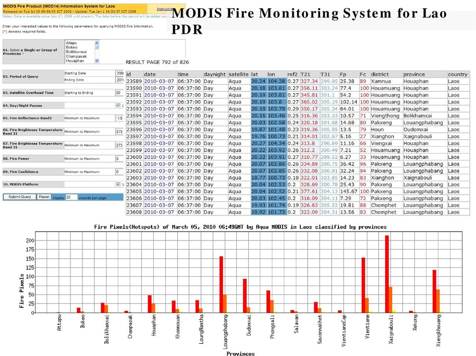
15 MODIS Fire Monitoring System for Lao PDR

16 China MODIS Fire Monitoring System for Lao PDR Vietnam Thailand Cambodia

17 MODIS Fire Monitoring System for Lao PDR
18 ~ 2 ~ Multi temporal Monitoring of Active fire Distribution in Lao PDR Regional and National Levels

19

20 Monthly Active Fire Distribution in Lao PDR ( ) March & April - highest

21 Provincial Active Fire Distribution in Lao PDR ( ) Louangphabang -highest
22 Active Fire Distribution in by district in Louangphabang province ( ) Nambak - highest
23 District with highest active fire distribution Visited Study areas
24 ~ 3 ~ Active Fire Distribution Pattern and cropping area identification
25 Jan Apr 2008 Jan Apr 2009 Jan Apr Active Fire Distribution Pattern and Cropping Area Identification
26 3. Active Fire Distribution Pattern and Cropping Area Identification
27 Rubber Sugar cane 3. Active Fire Distribution Pattern and Cropping Area Identification Sugarcane Highland rice plantation Corn Paddy field Rubber Coffee, Tea, Vegetables
28 3. Active Fire Distribution Pattern and Cropping Area Identification
29 3. Active Fire Distribution Pattern and Cropping Area Identification
30 3. Active Fire Distribution Pattern and Cropping Area Identification
31 3. Active Fire Distribution Pattern and Cropping Area Identification
32 3. Active Fire Distribution Pattern and Cropping Area Identification
33 3. Active Fire Distribution Pattern and Cropping Area Identification
34 3. Active Fire Distribution Pattern and Cropping Area Identification
35 3. Active Fire Distribution Pattern and Cropping Area Identification
36 ~ 4 ~ Detection of Frequently Burn Locations A Case Study in Oudomxay Province, Lao PDR
37 Oudomxay Study on the Detection of Frequently burn locations in Oudomxay Prov., Lao PDR Oudomxay Province ThetopographyofOudomxayismountainous,between 300 1,800 metres above sea level. Approximately 40,000 hectares of land are cultivated in Oudomxay, with rice being the main crop. Besides rice, important crops are corn, soybeans, fruits, vegetables, cassava, sugarcane, tobacco, cotton wool, tea and peanuts. In 2004, approximately 10,000 tons of sugarcane and 45,000 tons of corn were produced 37
38 Data used and Methodology Multi-Temporal Data 38
39 List of districts in Oudomxay province with burning frequency of 5, 6 & 7 times within the study period 39
40 Spatial Distribution of Frequently Burn Locations in Oudomxay province. The number shows on red placemark are burn frequency within the specific location in the period of study 40
41 List of districts in Oudomxay province with burning frequency of 2 times within the study period 41
42 List of districts in Oudomxay province with burning frequency of 3 times within the study period 42
43 List of districts in Oudomxay province with burning frequency of 4 times within the study period 43
44 List of districts in Oudomxay province with burning frequency of 5 times within the study period 44
45 List of districts in Oudomxay province with burning frequency of 6 & 7 times within the study period 45
46 Conclusions 1. MODIS has high potential for multi temporal disaster and environmental monitoring in regional scale, therefore it has been used to monitor the wildfire phenomenon in Lao PDR for various aspects as listed in the content. 2. With the collaboration between MAF, Lao PDR and AIT, the fire monitoring will be upgraded to new level of technical collaboration, and will be useful system to facilitate the fire information to MAF to understand the fire distribution in the country and implementation action on the ground. 3. The monitoring system for Lao PDR has been running since 2009, in order to make the capability of the system to be more efficient, the system was off during rainy season for maintenance and upgrading in term of software and hardware. 46
47 ~ CONTACT ~ vivarad@gmail.com vivarad@ait.ac.th 47
Inland Waterway Infrastructure - Mekong River cruise promoting factor. Tokyo September 2010
 Inland Waterway Infrastructure - Mekong River cruise promoting factor Tokyo September 2010 Mekong river system Mekong river system Land and resources: Parts of China, Myanmar and Viet Nam, nearly 1/3 of
Evaluation of Wildfire Duration Time Over Asia using MTSAT and MODIS
 Evaluation of Wildfire Duration Time Over Asia using MTSAT and MODIS Wataru Takeuchi * and Yusuke Matsumura Institute of Industrial Science, University of Tokyo, Japan Ce-504, 6-1, Komaba 4-chome, Meguro,
Processing of Fire Service Products for Wildfire Monitoring in Tanzania at MESA TAFORI Fire Station: The use of ArcGIS Software
 Processing of Fire Service Products for Wildfire Monitoring in Tanzania at MESA TAFORI Fire Station: The use of ArcGIS Software 1 S. Ernest* 1 Tanzania Forestry Research Institute (TAFORI), P.O Box 1854,
JAXA/AIT Collaboration for Capacity Building in Asia-Pacific
 JAXA/AIT Collaboration for Capacity Building in Asia-Pacific Lal Samarakoon Director, Geoinformatics Center, AIT, Thailand Visiting Senior Scientist, JAXA, Japan Content Education and training for capacity
REMOTE SENSING AND GIS ACTIVITIES IN ASIAN INSTITUTE OF TECHNOLOGY: EDUCATION, TRAINING AND RESEARCH
 Back REMOTE SENSING AND GIS ACTIVITIES IN ASIAN INSTITUTE OF TECHNOLOGY: EDUCATION, TRAINING AND RESEARCH Kiyoshi Honda Space Technology Applications and Research (STAR) Program Asian Institute of Technology,
EFFECTIVE APPROACH FOR CAPACITY BUILDING IN GIS AND REMOTE SENSING TECHNOLOGIES IN DEVELOPING COUNTRIES
 EFFECTIVE APPROACH FOR CAPACITY BUILDING IN GIS AND REMOTE SENSING TECHNOLOGIES IN DEVELOPING COUNTRIES Lal Samarakoon a,, Manzul K. Hazarika a and Yoko Inomata b a Geoinformatics Center, Asian Institute
Thailand s Organic 2011. Vitoon Panyakul Green Net Earth Net vitoon@greennet.or.th
 Thailand s Organic 2011 Vitoon Panyakul Green Net Earth Net vitoon@greennet.or.th Brief History (1) 1991 Chai Wiwat Agro-industry & Capital Rice Co started organic rice project 1992 Alternative Agriculture
Cambodian Agrarian Structure Study. 12 Figures. www.agrifoodconsulting.com
 12 Figures 311 30.0% 25.0% 20.0% Percentage Growth in GDP 15.0% 10.0% 5.0% Agriculture Forestry and Fisheries Industry Services Total 0.0% -5.0% -10.0% 1995 1996 1997 1998 1999 2000 2001 2002 2003 Compared
Background of Lao PDR
 Background of Lao PDR Lao PDR is a land link Country, situated in the centre of Indo-China and is surrounded by Cambodia, China, Myanmar, Thailand and Viet Nam Area - 236 800 km2 which approximately 87
Correlation Analysis of Factors Influencing Changes in Land Use in the Lower Songkhram River Basin, the Northeast of Thailand
 Correlation Analysis of Factors Influencing Changes in Land Use in the Lower Songkhram River Basin, the Northeast of Thailand Rasamee SUWANWERAKAMTORN and Chat CHANTHALUECHA Geo-informatics Centre for
Integration of GIS and Multivariate Statistical Analysis in Master Plan Study on Integrated Agricultural Development in Lao PDR
 Integration of GIS and Multivariate Statistical Analysis in Master Plan Study on Integrated Agricultural Development in Lao PDR GIS Makoto ISHIZUKA, Tetsunari GEJO, Shigeya OOTSUKA and Yukiyasu SUMI GIS
Asian Development Bank
 March 2012 Asian Development Bank Asian Development Bank SNV Netherlands Development Organization - - - - - - Inclusive Business and Social Enterprise in Vietnam Purpose, Methodology
Forest Fire Information System (EFFIS): Rapid Damage Assessment
: Rapid Damage Assessment") Forest Fire Information System (EFFIS): Fire Danger D Rating Rapid Damage Assessment G. Amatulli, A. Camia, P. Barbosa, J. San-Miguel-Ayanz OUTLINE 1. Introduction: what is the JRC 2. What is EFFIS 3.
Forest Fire Information System (EFFIS): Fire Danger D Rating Rapid Damage Assessment G. Amatulli, A. Camia, P. Barbosa, J. San-Miguel-Ayanz OUTLINE 1. Introduction: what is the JRC 2. What is EFFIS 3.
Ministry of Agriculture and Forestry. Strategy for reform in the Agriculture and Forestry Colleges towards 2020
 LAO PEOPLE S DEMOCRATIC REPUBLIC Peace Independence Democracy Unity Prosperity Ministry of Agriculture and Forestry Strategy for reform in the Agriculture and Forestry Colleges towards 2020 Vientiane,
Agricultural and Land Use: ENVISAT applications in Fujian Province
 Agricultural and Land Use: ENVISAT applications in Fujian Province Spatial Information Research Center, Fujian Province, Fuzhou University (http://www.sirc.) 2004-4-27 Main topics! About SIRC! The Chinese
Brazil s Response to Lower Commodity Prices Will Infrastructure Improvements Support Further Expansion?
 Brazil s Response to Lower Commodity Prices Will Infrastructure Improvements Support Further Expansion? By Dr. Michael Cordonnier www.soybeansandcorn.com soycorn@comcast.net 630-325-0192 (Chicago) Overview
growing sources of employment in the country. In
 SRI LANKA 8,000 7,000 6,000 5,000 Fig. 1: Employment by Major Economic Activity ('000s), 2002-2008 Agriculture, Hunting, Forestry, Mining and Wholesale and Retail Trade Hotels and Restaurants Agriculture,
Monitoring Overview with a Focus on Land Use Sustainability Metrics
 Monitoring Overview with a Focus on Land Use Sustainability Metrics Canadian Roundtable for Sustainable Crops. Nov 26, 2014 Agriclimate, Geomatics, and Earth Observation Division (ACGEO). Presentation
Status and trends in perception of Organic vegetable and fruit production in China
 Chinese-Danish Networking Status and trends in perception of Organic vegetable and fruit production in China Yuhui Qiao Dr. Associate Professor Department of Ecology and Ecological Engineering China Agricultural
CLIMATE CHANGE ADAPTATION ACTIVITIES
 CLIMATE CHANGE ADAPTATION ACTIVITIES AND EXPERIENCE IN LAO PDR 5th APN Southeast Asia Sub-Regional Cooperation Meeting, Climate Adaptation Seminar, Proposal Development Training Workshop 22-26 October
Application of Space Technology for Disaster monitoring and assessment current state in Vietnam
 Application of Space Technology for Disaster monitoring and assessment current state in Vietnam Lai Anh Khoi SPACE TECHNOLOGY INSTITUTE 8th GEOSS Asian Pacific Symposium Beijing, Sep. 09-11, 2015 Types
ASSESSMENT OF FOREST RECOVERY AFTER FIRE USING LANDSAT TM IMAGES AND GIS TECHNIQUES: A CASE STUDY OF MAE WONG NATIONAL PARK, THAILAND
 ASSESSMENT OF FOREST RECOVERY AFTER FIRE USING LANDSAT TM IMAGES AND GIS TECHNIQUES: A CASE STUDY OF MAE WONG NATIONAL PARK, THAILAND Sunee Sriboonpong 1 Yousif Ali Hussin 2 Alfred de Gier 2 1 Forest Resource
Viet Nam Science and Technology Development Towards 2020
 Viet Nam Science and Technology Development Towards 2020 Dr. Bui Van Quyen Director General of the National Agency for Southern Affairs (NASA) Ministry of Science and Technology (MOST) of Vietnam 1 Some
Summary of Evaluation Result
 Summary of Evaluation Result 1. Outline of the Project Country: Socialist Republic of Vietnam Issue/ Sector: Natural Environment Project Title: the project on the Villager Support for Sustainable Forest
First Technical Working Group Meeting and Training Workshop on Integrated River Basin Management in Key River Basins in Lao PDR
 Workshop Report First Technical Working Group Meeting and Training Workshop on Integrated River Basin Management in Key River Basins in Lao PDR Luang Prabang, Lao PDR September 30-October 5, 2013 Acronyms
JICA Training Course Plant Variety Protection course
 Session 4: DUS Training provided by members of the Union DUS Training organized by Japan Tsukasa KAWAKAMI Intellectual Property Division, Ministry of Agriculture, Forestry and Fisheries (MAFF) Japan 1
Review for Introduction to Remote Sensing: Science Concepts and Technology
 Review for Introduction to Remote Sensing: Science Concepts and Technology Ann Johnson Associate Director ann@baremt.com Funded by National Science Foundation Advanced Technological Education program [DUE
GIS. and ge and. (May, 2015)
") GIS and Remote Sensing Support for the Assessment of Historic Forest Cover Chang ge and GHG Emissions in Sanamxay District, Lao PDR (May, 2015) GIS and Remote Sensing Support for the Assessment of Historic
GIS and Remote Sensing Support for the Assessment of Historic Forest Cover Chang ge and GHG Emissions in Sanamxay District, Lao PDR (May, 2015) GIS and Remote Sensing Support for the Assessment of Historic
Logistics and Transport System along Asian Highway and Tran Asian Railway in Lao PDR
 Seminar on The Development of Integrated Transport and Logistics System in ASEAN and Pacific Sub-Region Logistics and Transport System along Asian Highway and Tran Asian Railway in Lao PDR UNESCAP, Bangkok
ArcGIS Agricultural Land Use Maps from the Mississippi Cropland Data Layer
 ArcGIS Agricultural Land Use Maps from the Mississippi Cropland Data Layer Fred L. Shore, Ph.D. Mississippi Department of Agriculture and Commerce Jackson, MS, USA fred_shore@nass.usda.gov Rick Mueller
Potential of Sugar cane monitoring using Synthetic Aperture Radar in Central Thailand
 Potential of Sugar cane monitoring using Synthetic Aperture Radar in Central Thailand Thanit Intarat 1, Preesan Rakwatin 1, Panu Srestasathien 1, Peeteenut Triwong 2, Chanwit Tangsiriworakul 2, and Samart
VITHYEA KHIEV Rural Development Bank of Cambodia Daun Penh District, Phnom Penh, Cambodia
 Experiences of Cambodia s Rural Development Bank Program on Agricultural Value Chain Finance VITHYEA KHIEV Rural Development Bank of Cambodia Daun Penh District, Phnom Penh, Cambodia Regional Training
Remote Sensing Image Server for GMS (Greater Mekong Sub-Region) Countries
 Countries") Remote Sensing Image Server for GMS (Greater Mekong Sub-Region) Countries Kiyoshi HONDA, Sarawut Ninsawat, Teerayut Horanont, Ryuzo Yokoyama, Amor V.M. Ines Space Technology Applications and Research (STAR)
Remote Sensing Image Server for GMS (Greater Mekong Sub-Region) Countries Kiyoshi HONDA, Sarawut Ninsawat, Teerayut Horanont, Ryuzo Yokoyama, Amor V.M. Ines Space Technology Applications and Research (STAR)
Agricultural Production and Research in Heilongjiang Province, China. Jiang Enchen. Professor, Department of Agricultural Engineering, Northeast
 1 Agricultural Production and Research in Heilongjiang Province, China Jiang Enchen Professor, Department of Agricultural Engineering, Northeast Agricultural University, Harbin, China. Post code: 150030
Aneeqa Syed [Hatfield Consultants] Vancouver GIS Users Group Meeting December 8, 2010
![Aneeqa Syed [Hatfield Consultants] Vancouver GIS Users Group Meeting December 8, 2010](/thumbs/27/11179985.jpg "Aneeqa Syed [Hatfield Consultants] Vancouver GIS Users Group Meeting December 8, 2010") NEAR-REAL-TIME FLOOD MAPPING AND MONITORING SERVICE Aneeqa Syed [Hatfield Consultants] Vancouver GIS Users Group Meeting December 8, 2010 SLIDE 1 MRC Flood Service Project Partners and Client Hatfield
NEAR-REAL-TIME FLOOD MAPPING AND MONITORING SERVICE Aneeqa Syed [Hatfield Consultants] Vancouver GIS Users Group Meeting December 8, 2010 SLIDE 1 MRC Flood Service Project Partners and Client Hatfield
Asia-Pacific Environmental Innovation Strategy (APEIS)
") Asia-Pacific Environmental Innovation Strategy (APEIS) Integrated Environmental Monitoring IEM) Dust Storm Over-cultivation Desertification Urbanization Floods Deforestation Masataka WATANABE, National
Asia-Pacific Environmental Innovation Strategy (APEIS) Integrated Environmental Monitoring IEM) Dust Storm Over-cultivation Desertification Urbanization Floods Deforestation Masataka WATANABE, National
DEVELOPMENT OF OPEN SOURCE SOFTWARE FOR MULTI-TEMPORAL DISASTER MONITORING ACROSS NETWORK WITH DYNAMIC DATA EXCHANGE
 DEVELOPMENT OF OPEN SOURCE SOFTWARE FOR MULTI-TEMPORAL DISASTER MONITORING ACROSS NETWORK WITH DYNAMIC DATA EXCHANGE Wanapong Kaewsing, Anusorn Rungsripanij, Pisut Naknuenwai, Siam Lawawirojwong, Sitthisak
Dr. Ornprapa P. Robert
 Dr. Ornprapa P. Robert is currently an assistant professor of environmental science at the dept. of environmental science, Silpakorn University, Thailand. She received her PhD of Remote Sensing and GIS
Overview of NASA Applied Remote Sensing Training Program on Water Resources and Disaster Management
 Overview of NASA Applied Remote Sensing Training Program on Water Resources and Disaster Management ARSET Applied Remote SEnsing Training A project of NASA Applied Sciences Outline About ARSET ARSET Trainings
Rural developments in Latin America, 1930-2015. Michiel Baud CEDLA
 Rural developments in Latin America, 1930-2015 Michiel Baud CEDLA Export-orientation, 1870-1930 Expansion agrarian frontier Agrarian monocultures Replacement of traditional large landowners New forms of
Thailand s Great Undeveloped Resource
 Thailand s Great Undeveloped Resource INVESTMENT STRATEGY The primary goal of is to aggregate a significant land package targeting potash, at a very low cost of entry, 6 claims for a total of 96 sq. km.
Environment and Society in Developing Countries. Ideas for Master s and PhD projects
 Environment and Society in Developing Countries Ideas for Master s and PhD projects Ex ante Criteria! 1) Experience? 2) Interest? 3) Relevance? 4) Practicability? 1) Time (fieldwork and analysis) 2) Research
Selecting the appropriate band combination for an RGB image using Landsat imagery
 Selecting the appropriate band combination for an RGB image using Landsat imagery Ned Horning Version: 1.0 Creation Date: 2004-01-01 Revision Date: 2004-01-01 License: This document is licensed under a
AIC Farm Bill Brief #1
 University of California July 2007 Agricultural Issues Center AIC Farm Bill Brief #1 The Farm Bill and California Food and Agriculture* Daniel A. Sumner** Every five years or so the United States reconsiders
Welcome to NASA Applied Remote Sensing Training (ARSET) Webinar Series
 Webinar Series") Welcome to NASA Applied Remote Sensing Training (ARSET) Webinar Series Introduction to Remote Sensing Data for Water Resources Management Course Dates: October 17, 24, 31 November 7, 14 Time: 8-9 a.m.
Welcome to NASA Applied Remote Sensing Training (ARSET) Webinar Series Introduction to Remote Sensing Data for Water Resources Management Course Dates: October 17, 24, 31 November 7, 14 Time: 8-9 a.m.
Mapping Forest-Fire Damage with Envisat
 Mapping Forest-Fire Damage with Envisat Mapping Forest-Fire Damage Federico González-Alonso, S. Merino-de-Miguel, S. García-Gigorro, A. Roldán-Zamarrón & J.M. Cuevas Remote Sensing Laboratory, INIA, Ministry
Caring Societies Ageing and Health in the Laos PDR. Presented by Mr Sisavath KHOMPHONH Deputy Director of Pension, Invalid and Handicap Department
 Caring Societies Ageing and Health in the Laos PDR Presented by Mr Sisavath KHOMPHONH Deputy Director of Pension, Invalid and Handicap Department The overwiev of Lao P.D.R 1. Lao PDR is a landlocked country,
Kai Becker Waukon Senior High Waukon, IA
 Kai Becker Waukon Senior High Waukon, IA East Timor: A Look to the Future The Democratic Republic of Timor-Leste, also known as East Timor, is a tiny island nation in Southeast Asia. East Timor has suffered
Country Report On Human Resource Development In Food-related Area Through Partnership With ASEAN Universities. Dr. Aye Aye Thwe Ohnmar Myint MYANMAR
 Country Report On Human Resource Development In Food-related Area Through Partnership With ASEAN Universities Dr. Aye Aye Thwe Ohnmar Myint MYANMAR Area - 676,577 km 2 Latitude - 9 o 32 N and 28 o 31 N
U.S. Agriculture and International Trade
 Curriculum Guide I. Goals and Objectives A. Understand the importance of exports and imports to agriculture and how risk management is affected. B. Understand factors causing exports to change. C. Understand
Sengsavanh College. ICT development in Lao PDR. Sakdina Rosant. Ministry of education. IT Manager. AEN Confrence 2004,Pan pacific Singapore 1
 Ministry of education Sengsavanh College ICT development in Lao PDR Sakdina Rosant IT Manager Singapore 1 Main point of presentation Review of ICT development Internet development in Lao Some Important
feature articles Thanks to NASA s investment remote-sensing platforms like Terra, Aqua, Landsats 1 7, and the Earth Observing-1
 14 The Earth Observer March - April 2012 Volume 24, Issue 2 DEVELOP Students Battle Wildfires from Space Using NASA Earth Observations Jamie Favors, DEVELOP National Program, NASA s Langley Research Center,
A remote sensing instrument collects information about an object or phenomenon within the
 Satellite Remote Sensing GE 4150- Natural Hazards Some slides taken from Ann Maclean: Introduction to Digital Image Processing Remote Sensing the art, science, and technology of obtaining reliable information
Outlook for the 2013 U.S. Farm Economy
 Outlook for the 213 U.S. Farm Economy Kevin Patrick Farm and Rural Business Branch Resource and Rural Economics Division Highlights Net farm income in 213 forecast: $128.2 billion Net cash income in 213
OBJECT BASED IMAGE CLASSIFICATION AND WEB-MAPPING TECHNIQUES FOR FLOOD DAMAGE ASSESSMENT
 OBJECT BASED IMAGE CLASSIFICATION AND WEB-MAPPING TECHNIQUES FOR FLOOD DAMAGE ASSESSMENT Ejaz Hussain, KyoHyouk Kim, Jie Shan {ehussain, kim458, jshan}@ecn.purdue.edu Geomatics Engineering, School of Civil
Survey and Mapping Activities in Vietnam *
 UNITED NATIONS E/CONF.100/CRP.1 ECONOMIC AND SOCIAL COUNCIL Eighteenth United Nations Regional Cartographic Conference for Asia and the Pacific Bangkok, 26-29 October 2009 Item 7(a) of the provisional
OUTLINES. Earth Observation Satellite Program of Vietnam and applications for disaster management
 UNESCAP ICC & HLDM Meetings, Bangkok 26 28/11/2013 Earth Observation Satellite Program of Vietnam and applications for disaster management OUTLINES 1. VNREDSat-1 (VAST*) - Optical 2. VNREDSat-1B (VAST)
Salavanh Province SAL/PR/04: Sustainable Livestock Health Management System for Salavanh Province
 Salavanh Province SAL/PR/04: Sustainable Livestock Health Management System for Salavanh Province Subproject Name Country Province Subproject code Number Subproject type Source of Funding/Amount ADB and
Moderate- and high-resolution Earth Observation data based forest and agriculture monitoring in Russia using VEGA Web-Service
 Moderate- and high-resolution Earth Observation data based forest and agriculture monitoring in Russia using VEGA Web-Service Sergey BARTALEV and Evgeny LOUPIAN Space Research Institute, Russian Academy
Land Use/ Land Cover Mapping Initiative for Kansas and the Kansas River Watershed
 Land Use/ Land Cover Mapping Initiative for Kansas and the Kansas River Watershed Kansas Biological Survey Kansas Applied Remote Sensing Program April 2008 Previous Kansas LULC Projects Kansas LULC Map
CHAPTER 3 RESEARCH DESIGN
 CHAPTER 3 RESEARCH DESIGN 3.1 Introduction In general, micro-hydropower systems operate as Run-of-River type which means that neither a large dam or water storage reservoir is built nor is land flooded.
Monitoring Soil Moisture from Space. Dr. Heather McNairn Science and Technology Branch Agriculture and Agri-Food Canada heather.mcnairn@agr.gc.
 Monitoring Soil Moisture from Space Dr. Heather McNairn Science and Technology Branch Agriculture and Agri-Food Canada heather.mcnairn@agr.gc.ca What is Remote Sensing? Scientists turn the raw data collected
Spectral Response for DigitalGlobe Earth Imaging Instruments
 Spectral Response for DigitalGlobe Earth Imaging Instruments IKONOS The IKONOS satellite carries a high resolution panchromatic band covering most of the silicon response and four lower resolution spectral
GIS BASED LAND INFORMATION SYSTEM FOR MANDAL SOUM, SELENGE AIMAG OF MONGOLIA
 GIS BASED LAND INFORMATION SYSTEM FOR MANDAL SOUM, SELENGE AIMAG OF MONGOLIA B. Tuul GTZ, Land Management and Fiscal Cadastre project, Government building 12, ALAGCaC, Ulaanbaatar, Mongolia tuul1119@yahoo.com,
Istanbul Technical University-Center for Satellite Communications and Remote Sensing (ITU-CSCRS)
") Istanbul Technical University-Center for Satellite Communications and Remote Sensing (ITU-CSCRS) Istanbul Technical University, Center for Satellite Communications and Remote Sensing (ITU-CSCRS) was originally
Istanbul Technical University-Center for Satellite Communications and Remote Sensing (ITU-CSCRS) Istanbul Technical University, Center for Satellite Communications and Remote Sensing (ITU-CSCRS) was originally
The NASA NEESPI Data Portal to Support Studies of Climate and Environmental Changes in Non-boreal Europe
 The NASA NEESPI Data Portal to Support Studies of Climate and Environmental Changes in Non-boreal Europe Suhung Shen NASA Goddard Space Flight Center/George Mason University Gregory Leptoukh, Tatiana Loboda,
Training Materials for Scaling-up Climate Change Adaptation and Modified Procedures
 Coastal Adaptation and Resilience Planning Component Training Materials for Scaling-up Climate Change Adaptation and Modified Procedures December 2013 ii Training Materials for Scaling-up Climate Change
Mainstreaming Disaster Risk Reduction into National and Sectoral Development Process
 Mainstreaming Disaster Risk Reduction into National and Sectoral Development Process Safer Training Health Course Facilities Regional Consultative Committee on Disaster Management (RCC) Training Course
The workshop in Taunggyi as well as this publication are funded by the Australian Government. This is not an official document of the United Nations.
 The workshop in Taunggyi as well as this publication are funded by the Australian Government. This is not an official document of the United Nations. For information only. Opinions expressed in this publication
U.S. Farm Policy: Overview and Farm Bill Update. Jason Hafemeister 12 June 2014. Office of the Chief Economist. Trade Bureau
 U.S. Farm Policy: Office of the Chief Economist Trade Bureau Overview and Farm Bill Update Jason Hafemeister 12 June 2014 Agenda Background on U.S. Agriculture area, output, inputs, income Key Elements
Economic Integration of Greater-Mekong Sub-Region and the Role of Small and Medium Enterprises
 Economic Integration of Greater-Mekong Sub-Region and the Role of Small and Medium Enterprises Dr. Kitti Limskul Ktti.L@Chula.ac.jp Vice Minister for Office of Prime Minister, Government of Thailand (Former
International Training Program 2010 Management of Flood Control and Disaster Mitigation LOGO
 International Training Program 2010 Management of Flood Control and Disaster Mitigation LOGO June 2010 / China Prepared by HOY SEREIVATHANAK REASEY Royal University of Phnom Penh 1 Country Risk Profile
12 th -16 th May 2013 ---------------------------------------------------------------------------------------------------- Country Progress Report
 ASEAN INTER-PARLIAMENTARY ASSEMBLY The Tenth Meeting of the AIPA Fact-Finding Committee (AIFOCOM) to Combat the Drug Menace Bandar Seri Begawan, Brunei Darussalam 12 th -16 th May 2013 ----------------------------------------------------------------------------------------------------
1. Outline of Evaluation Study... 2. 3. Results of Evaluation... 5
 Summary of Evaluation Study Results Training Program in Japan for Laos Contents 1. Outline of Evaluation Study... 2 1-1 Objective of Evaluation Study... 2 1-2 Members of Evaluation Study Team... 2 1-3
Sustainable Management of Natural Resources in Central Vietnam SMNR-CV. Summary Report. Mushroom Sub-sector in Quang Binh Province.
 Sustainable Management of Natural Resources in Central Vietnam Summary Report Mushroom Sub-sector in Quang Binh Province \ prepared by Dong Hoi May 2008 1 Table of Contents I. Overview of mushroom sub-sector
June 2015 From Nature to Green Energy
 Business Overview: 2015Q2 Performance June 2015 Fully Integrated Sugar & Energy Company Note : Conversion Ratio 1 ton of Sugar Cane = 105 kg of sugar + 45 kg of Molasses + 50 kg of Filter Cake + 295 kg
A review of agricultural and monsoon conditions
 For the past 2 years India has experienced drought like conditions. This year the Indian Meteorological Department (IMD) has predicted that there will above normal monsoon. If monsoons this year are good,
Key global markets and suppliers impacting U.S. grain exports BRICs
 Key global markets and suppliers impacting U.S. grain exports BRICs Levin Flake Senior Agricultural Economist, Global Policy Analysis Division, OGA/FAS/USDA TEGMA Annual Meeting January 23 rd, 2015 U.S.
How To Prepare For An Emergency Food Security Crisis
 Famine Early Warning Systems Network PROJECTED FOOD SECURITY IMPACTS OF EBOLA IN GUINEA, LIBERIA, AND SIERRA LEONE October 8, 2014 Washington, DC Guinea, Liberia, and Sierra Leone are FEWS NET remote monitoring
DISASTER MANAGEMENT POLICY, LEGAL AND INSTITUTIONAL ARRANGEMENTS AND PLANS IN CAMBODIA
 DISASTER MANAGEMENT POLICY, LEGAL AND INSTITUTIONAL ARRANGEMENTS AND PLANS IN CAMBODIA February 2002 Asian Disaster Preparedness Center PO Box 4 Klong Luang Pathumthani 12120 Thailand CONTENTS I. Country
Working Papers in Development Sociology and Social Anthropology
 Working Papers in Development Sociology and Social Anthropology Bielefeld University Faculty of Sociology P.O. Box: 10 01 31 33501 Bielefeld Germany Tel.: +49-521-106-6944 Fax: +49-521-106-2980 http://www.uni-bielefeld.de/tdrc
ASEAN 2015: Implications on Philippine Human Resource Development
 1 ASEAN 2015: Implications on Philippine Human Resource Development Undersecretary Adrian S. Cristobal Jr. Department of Trade and Industry Managing Head, Board of Investments 2nd National Technology Vocation
The Agricultural Sector in Cambodia: Trends, Processes and Disparities
 The Agricultural Sector in Cambodia: Trends, Processes and Disparities Jan-Peter Mund Abstract: The agricultural Sector in Cambodia still contributes the dominant quantity to the GDP. It is the most important
Environmental Law Enforcement in Zimbabwe. Farai Michael Nyahwa
 Environmental Law Enforcement in Zimbabwe By Farai Michael Nyahwa Presentation Breakdown Institutional Arrangement for Environmental Law Enforcement in Zimbabwe Major Environmental Issues of Concern In
LEGAL FRAMEWORK, POTENTIAL AND OUTLOOK FOR BIOENERGY SECTOR IN VIETNAM
 Conference on Bioenergy in Viet Nam October 6 th, 2014, HCM City LEGAL FRAMEWORK, POTENTIAL AND OUTLOOK FOR BIOENERGY SECTOR IN VIETNAM By Nguyen Duc Cuong Director of Center for Renewable Energy & CDM,
The Growing Role of Contract Farming in Agri-food Systems Development: Drivers, Theory and Practice
 The Growing Role of Contract Farming in Agri-food Systems Development: Drivers, Theory and Practice Carlos Arthur B. da Silva, Ph.D. FAO Agricultural Management, Marketing and Finance Service Agricultural
Hello Cambodia Feasibility Study
 1 Cambodia, with an area of 69,898 square miles, is bordered by Thailand, Laos and Vietnam and has a coastline on the Gulf of Thailand. Apart from the Cardamom Mountains in the south-west and uplands in
Monitoring Global Crop Condition Indicators Using a Web-Based Visualization Tool
 Monitoring Global Crop Condition Indicators Using a Web-Based Visualization Tool Bob Tetrault, Regional Commodity Analyst, and Bob Baldwin, GIS Specialist, USDA, Foreign Agricultural Service, Washington,
Policy, Legislation and Institutional Arrangements:
 Policy, Legislation and Institutional Arrangements: An ADPC Commentary on Innovation and Good Practice in DRR Governance in Asia Presentation by A.J Rego (ADPC) for the Seventh IIASA -DPRI Forum on Integrated
NEW GEN SUPPORT SYSTEM FOR AGRICULTURAL CROPS FOR KANCHEEPURAM DISTRICT SOUTH INDIA
 NEW GEN SUPPORT SYSTEM FOR AGRICULTURAL CROPS FOR KANCHEEPURAM DISTRICT SOUTH INDIA D. Soundarrajan 1, Priyadharshini 2, Dr.M.M.Vijayalakshmi 3, Dr.E. Natarajan 4 1 Research Scholar, 3 Professor, Department
THE GREAT RUAHA RIVER PROFILE
 THE GREAT RUAHA RIVER PROFILE By Willie Mwaruvanda A Paper presented at the Clivet Project Inception Workshop,Blue Pearl Hotel Ubungo Plaza, Dar es Salaam 27 th November, 2009. 1 The Rufiji Basin Tanzania
Measurement of the effect of biomass burning aerosol on inhibition of cloud formation over the Amazon
 Supporting Online Material for Koren et al. Measurement of the effect of biomass burning aerosol on inhibition of cloud formation over the Amazon 1. MODIS new cloud detection algorithm The operational
AGRI- BUSINESS IN ARGENTINA A SEMINAR ON INVESTMENT OPPORTUNITIES
 AGRI- BUSINESS IN ARGENTINA A SEMINAR ON INVESTMENT OPPORTUNITIES Maximiliano Moreno Director of Multilateral Negotiations Ministry of Agriculture, Livestock and Fisheries Argentina NEW INTERNATIONAL ENVIRONMENT
MALAWI Food Security Outlook July to December 2015. High prices, declining incomes, and poor winter production cause Crisis food insecurity
 MALAWI Food Security Outlook July to December 2015 High prices, declining incomes, and poor winter production cause Crisis food insecurity KEY MESSAGES Current acute food security outcomes, July 2015.
Plan on establishment of National Committee on Geographical Names and Spatial Data Infrastructure in Viet Nam *
 UNITED NATIONS E/CONF.104/IP.23 ECONOMIC AND SOCIAL COUNCIL Twentieth United Nations Regional Cartographic Conference for Asia and the Pacific Jeju, 6-9 October 2015 Item 7(b) of the provisional agenda
Guidelines on Implementation of the Procedures for Water Use Monitoring
 For Sustainable Development Guidelines on mplementation of the Procedures for Water Use Monitoring P.O. Box 6101, Vientiane, Lao PDR Telephone: (856-21) 263 263 Facsimile: (856-21) 263 264 Email: mrcso,mrcmekon~.org
Long-term Agricultural Growth in India, Pakistan, and Bangladesh from 1901/02 to 2001/02
 Long-term Agricultural Growth in India, Pakistan, and Bangladesh from 1901/02 to 2001/02 PIDE Seminar, Nov 28, 2011 Takashi Kurosaki (Hitotsubashi University) kurosaki@ier.hit-u.acc.jp 1 Background of
Assessment of Economic, Social and Environmental Costs and Benefits of Savan Vegas Casino & Hotel: Case Study in Savannakhet Province
 Assessment of Economic, Social and Environmental Costs and Benefits of Savan Vegas Casino & Hotel: Case Study in Savannakhet Province Prepared by: Photo: NERI IUCN Lao PDR & The National Economic Research
education. In contrast, workers engaged in fishing worked an average of 61.7 hours per
 THAILAND 40,000 Fig. 1: Employment by Major Economic Activity ('000s), 2002-2008 Agriculture, Forestry, Agriculture, Forestry & 35,000 30,000 25,000 20,000 15,000 10,000 5,000 0 2002 2004 2006 2008 Mining
Presented by D. R. Khanal Chairman Institute for Policy Research and Development (IPRAD)
") Work in Progress Construction of GTAP Compatible Input Output (I/O) Table and Social Accounting Matrix (SAM) with Limited Data Base : Nepalese Experience Presented by D. R. Khanal Chairman Institute for
Work in Progress Construction of GTAP Compatible Input Output (I/O) Table and Social Accounting Matrix (SAM) with Limited Data Base : Nepalese Experience Presented by D. R. Khanal Chairman Institute for