Projecting 21 st Century Coastal Vulnerability for Southern California Using the Coastal Storm Modeling System (CoSMoS)
|
|
|
- Anthony Phelps
- 7 years ago
- Views:
Transcription
 Patrick Barnard USGS")

1 Projecting 21 st Century Coastal Vulnerability for Southern California Using the Coastal Storm Modeling System (CoSMoS) Patrick Barnard USGS Coastal and Marine Geology Program Pacific Coastal and Marine Science Center, Santa Cruz, CA U.S. Department of the Interior U.S. Geological Survey

2 Temperature Change NASA Goddard Institute for Space Studies


3 Recent Sea Level Rise Global SLR is accelerating: 20th century = 2 mm/yr (e.g., Church et al., 2004) 1993-present = 3 mm/yr (e.g., Merrifield et al., 2009) Regional factors: The global sea level rise signal is NOT spatially uniform due to variations in: prevailing wind and ocean circulation patterns ocean temperature and salinity ( steric effect ) gravitational forces ( glacial fingerprinting ) NOAA, 2011

 but perhaps a shift in styles McPhaden et al.")
4 Recent Findings- Storms Storms and average winter and extreme waves are getting larger and more frequent for much of U.S. West Coast No evidence for changes in the strength or frequency of El Niños over last ~150 years (Ray and Giese, 2012) but perhaps a shift in styles McPhaden et al. (2006) Graham and Diaz (2001) Allan and Komar (2006) Lee and McPhaden (2010)
 -93 cm of sea level rise by 2100")
 -includes gl")

5 Projections for Southern California SLR for Los Angeles (NRC, 2012) -28 cm of sea level rise by 2050 (range cm) -93 cm of sea level rise by 2100 (range cm) -includes global and regional effects (e.g., wind and circulation patterns, sea level fingerprint, glacial isostatic adjustment, tectonics) Storms for Southern California (Bromirski et al., 2012; USGS) -No significant changes in wave height -Extreme events approach from ~10-15 degrees further south
 Sea level will rise for several")
6 Sea Level Rise Beyond 2100 The Copenhagen Diagnosis, to 5.5 m of SLR by 2500 using latest IPCC Models (2013) Sea level will rise for several centuries after stabilization


7 What is the problem? Climate change, including sea level rise, changing wave climates, and storms will place additional stresses on coastal systems worldwide Coastal flooding from SLR alone could displace ~200 million people by 2100 Nationally, $1.4 trillion of coastal property could be at risk at high tide by the end of the century Hurricane Sandy caused $50 billion in damage El Niño storms caused more than $200 million in damage to California 500,000 people, one million jobs, and $100 billion in property are threatened by climate change along the California coast over the next century In San Diego County: 10,000 people and $2 billion in property at risk (not inclu. river discharge, waves, coastal change, changes in storms, etc.)


8 Coastal Impact of Projected Climate Trends Accelerated beach erosion rates Greater incidence of cliff failures Landward translation of coastal flooding and inundation More dangerous navigation conditions Beach/shore safety more often compromised Saltwater intrusion into coastal aquifers La Jolla, CA- Jan 2010 (A. Young) Shore & Beach, 1989

9 Southern California Vulnerability

10 Critical Infrastructure
 Isostasy Local")

11 Coastal Vulnerability Considerations Global factors: Eustatic sea level Regional factors: Ocean circulation patterns Glacial fingerprinting Tectonics (large-scale) Isostasy Local factors: Subsidence Local tectonic deformation Fluvial discharge AND sediment supply changes Development and restoration Seasonal and storm impacts: Steric effects Waves and storm surge River discharge


12 Coastal Vulnerability Approaches STATIC: NOAA SLR Viewer Passive model, hydrological connectivity Tides only (MHHW) Excellent elevation data, datum control Wetland migration model, socioeconomic impacts 1 st order screening tool DYNAMIC: CoSMoS GCM ensemble forcing Includes wind, waves, sediment transport, fluvial discharge, and vertical land movement rates Range of SLR and storm scenarios Flooding extent explicitly modeled, hydrological connectivity Our Coast Our Future:
 wave run-up wave set-up")

13 Components of Total Water Level Predictions swash zone breaker zone H decreases rapidly due to breaking waves increase in height towards breaking zone (shoaling) wave run-up wave set-up storm surge seasonal effects tide difference sea level rise h R h wv h ss h se h tide h slr 2 m m 0.3 m 0.3 m 2 m 1 m d br H br MSL (datum) Stinson Beach 50 cm SLR SLR only SLR + annual storm

14 What makes CoSMoS unique? Explicit, deterministic modeling of all the relevant physics of a coastal storm using the most sophisticated global climate and ocean modeling tools Waves are modeled at the global scale forced from the most sophisticated Global Climate Models (GCMs) developed for IPCC 2013, and then dynamically downscaled, along with regional additions of wind, atmospheric pressure, tides and sea level rise, to produce hazards projections at the parcel scale Scenarios feature the full spectrum of SLR rise (0-2 m, 5 m) and coastal storms (daily-100 year return) to meet every possible planning horizon Developing coastal vulnerability tools with guidance from federal (e.g., NOAA, NPS), state (e.g., California State Parks), and city governments (City of San Diego, L.A., and San Francisco) to meet their planning and adaptation needs


15 Identifying Future Risk with CoSMoS 1. Global forcing using the latest climate models 2. Drives global and regional wind/wave models 3. Scaled down to local hazards projections

16 CoSMoS Version 1.0- SoCal Outer coast focus- protected bays not modeled Flooding based on maximum wave run-up Limited set of scenarios ArKStorm January 2010 hindcast January 2010 hindcast + 50 and 100 yr SLR per Rahmstorf (2007)


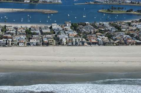
17 Del Mar P. Barnard

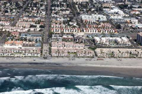
18 Mission Bay

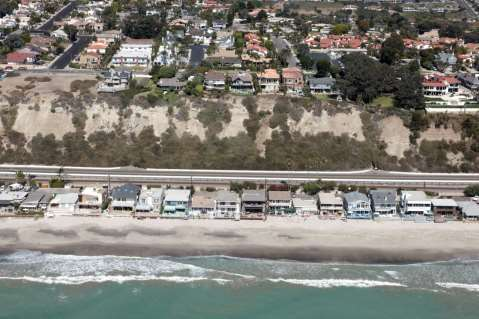
19 Imperial Beach


20 CoSMoS 2.0- CenCal/NorCal (Our Coast- Our Future)
 Vertical land motion, incl.")
21 CoSMoS 2.1- SF Bay In-bay generated waves and outer coast swell penetration River discharge, incl. 21 st century delta discharge projections Hydrological connectivity Levees (100s of kms) Vertical land motion, incl. projections of tidal marsh accretion and land uplift/subsidence Study Area

22 CoSMoS 2.1- SF Bay Our Coast- Our Future tool:
23 Uncertainty Our Coast- Our Future tool:


24 XBEACH Open coast CoSMoS 3.0 Southern California Global Global conditions of future climate scenarios Regional Tides, water levels, and regional forcing SWAN wave model Local High resolution hydrodynamics and waves GCM winds Regionalized storm response Delft FLOW-WAVE WW3 wave model 20-year storm return Fluvial discharge VLM Coastal change results projected onto hi-res DEM

25 USC Sea Grant The Urban Ocean Program Funds research Community outreach & education Technical assistance to local/regional government 10 Million by the Sea Climate Change Science & Planning Coastal Ecosystem Science Coastal Management Maritime Affairs


 Photo: Monica Ly")
26 Southern California Coastal Impacts Project Stakeholder Engagement and Capacity Building SoCal Sub-Regions Santa Barbara, Ventura, L.A., O.C. & San Diego Initial Process Workshops Webinar series (2015 until model results are available) Technical Outreach Workshop (Summer 2016) Photo: Monica Ly Photo: Marika Schulhof
 and Dr.")
27 Southern California Coastal Impacts Project San Diego Workshop held on Oct. 30, 2014 Presentations & info available here: Upcoming Webinar Beach Dynamics & Processes March 17, am 12pm Presenters Dr. Ron Flick (SIO) and Dr. Karen Martin (Pepperdine) Register: Sea Level Rise & Coastal Impacts Professional Development Webinar Series Webinar 2: Why Beaches Matter - Beach Dynamics & Ecology March 17, :00 am - 12:00 pm Register: As Southern Californians, we highly value the beaches that provide us with our endless summer culture. Beach-related tourism is a major economic driver for our coastal counties, with an estimated $16.5 billion in tourism expenditur es in 2012 for L.A. County alone. Beaches also provide a critical s firt line of defense against sea level rise and coastal storms. Maintaining our beaches maintains our way of life. Featured Speakers: Dr. Reinhard ( Ron ) Flick, Scripps Institution of Oceanography Dr. Karen Martin, Pepperdine University Webinar focus: Discuss the physical forcings that shape our coastline. Learn about the ecology of our beaches and how our actions impact the other organisms who live along the coast. Discuss strategies to help maintain our beaches. USC Sea Grant Website: dornsife.usc.edu/uscseagrant/adaptla-webinars

28 Southern California Coastal Impacts Project City of Imperial Beach SLR Adaptation Planning Study Revell Coastal lead consultant; USC SG and Tijuana River NERR providing support Utilizing adaptive management approach For more information on SCCIP Juliette Finzi Hart

29 Digital Elevation Model (DEM)
")
30 Digital Elevation Model (DEM) Scripps
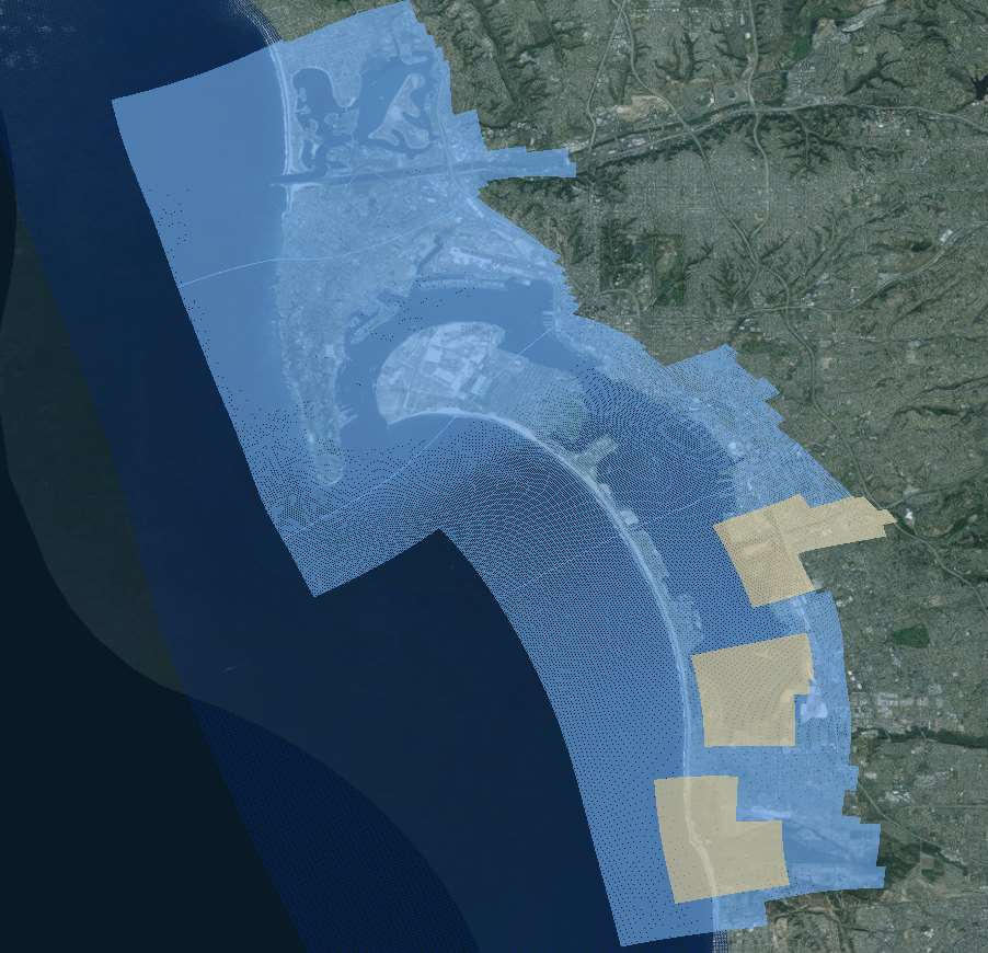

31 San Diego High-Resolution Grids

32 Future Shoreline Change P. Barnard Rising sea level will drive shorelines further inland, increasing physical and economic impacts Reduced sediment supply from dams, dredging, shoreline armoring, etc., likely to further exacerbate the problem For CoSMoS 3.0: focus on both sandy beach and cliff changes, and integrating those projections into the future flood scenarios


33 Controls on Cliff Behavior

34 Elevation (m) San Onofre/Camp Pendleton Cliff Retreat + wave & rainfall time series + sea level rise + talus deposition & erosion + landslide threshold Cross-shore distance (m)


35 Highlights of New SoCal Work Multi-agency collaboration featuring top coastal and climate scientists from Scripps, Oregon State University, private sector, and USGS Long-term coastal evolution modeled, including sandy beaches and cliffs Downscaled winds from GCMs to get locally-generated seas and surge Discharge from rivers for event response and long-term sediment supply Preliminary scenarios delivered in fall 2015, final in summer 2016 *For more information, contact Patrick Barnard: USGS CoSMoS website: Our Coast- Our Future tool:
Predicting Coastal Hazards: A Southern California Demonstration
 Predicting Coastal Hazards: A Southern California Demonstration Patrick Barnard United States Geological Survey Coastal and Marine Geology Team Santa Cruz, CA Southern California Multi-hazards Demonstration
An Initial Assessment of the Impacts of Sea Level Rise to the California Coast
 An Initial Assessment of the Impacts of Sea Level Rise to the California Coast Photo by D. Revell 2/23/08 California Coastal Records Project Dr. David Revell and Matt Heberger, P.E. Dr. Peter Gleick, Bob
ARkStorm: California s Other Big One!
 ARkStorm: California s Other Big One! Understanding the Impacts of Massive Winter Storms Mark Jackson Meteorologist in Charge NOAA/National Weather Service Los Angeles/Oxnard What is ARkStorm? Emergency-preparedness
Sea Level Change. Miami-Dade Sea Level Rise Task Force
 Sea Level Change and LongProgram Range Everglades Restoration Climate Water Resources Planning for Florida Change Application Concerns of USACE andguidance Draft Sea Level on Sea Rise Level Planning Change
South Florida Sea Level Rise Projections and Flood Risk Concerns
 South Florida Sea Level Rise Projections and Flood Risk Concerns MIAMI MIAMI Biscayne Bay Glenn B. Landers, P.E. Planning and Policy Division Jacksonville District EVERGLADES NATIONAL PARK USACE Flood
Climate Change. Lauma M. Jurkevics - DWR, Southern Region Senior Environmental Scientist
 Climate Change A n o t h e r F a c t o r i n M a n a g i n g S o u t h e r n C a l i f o r n i a s W a t e r R e s o u r c e s Lauma M. Jurkevics - DWR, Southern Region Senior Environmental Scientist USEPA-Region
LOCAL COASTAL PROGRAM PLANNING GRANTS JOINT APPLICATION ANNOUNCEMENT & INSTRUCTIONS APRIL 23, 2014
 LOCAL COASTAL PROGRAM PLANNING GRANTS JOINT APPLICATION ANNOUNCEMENT & INSTRUCTIONS APRIL 23, 2014 The State of California is pleased to announce grant funding for FY14-15 to support local governments
Los Angeles County. Open Pacific Coast Study. California Coastal Analysis and Mapping Project
 Los Angeles County Open Pacific Coast Study California Coastal Analysis and Mapping Project December 2011 Open Pacific Coast Counties Phase 1 Phase 2 California Coastal Analysis and Mapping Project Risk
Mariana Leckner, Ph.D., Professor, American Military University Thomas O. Herrington, Ph.D. Associate Professor, Stevens Institute of Technology
 Mariana Leckner, Ph.D., Professor, American Military University Thomas O. Herrington, Ph.D. Associate Professor, Stevens Institute of Technology National Hydrologic Warning Council Training Conference
Tuesday May 26, 2015 Morning Program
 Tuesday May 26, 2015 Morning Program 8:00-5:00 Registration (Lobby/Exhibitor Area) 9:30-10:00 Welcome And Opening Remarks Steven Aceti, J.D., Executive Director, California Coastal Coalition Mayor Mark
A Paper From: California Climate Change Center
 THE IMPACTS OF SEA-LEVEL RISE ON THE CALIFORNIA COAST A Paper From: California Climate Change Center Prepared By: Matthew Heberger, Heather Cooley, Pablo Herrera, Peter H. Gleick, and Eli Moore of the
Climate change impacts on city of Gdansk and its vicinity (Vistula Delta, Poland)
") Final International ASTRA Conference Espoo, 10-11 December, 2007 Climate change impacts on city of Gdansk and its vicinity (Vistula Delta, Poland) Dorota Kaulbarsz, Zbigniew Kordalski, Wojciech Jeglinski
Final International ASTRA Conference Espoo, 10-11 December, 2007 Climate change impacts on city of Gdansk and its vicinity (Vistula Delta, Poland) Dorota Kaulbarsz, Zbigniew Kordalski, Wojciech Jeglinski
Oregon. Climate Change Adaptation Framework
 Oregon Climate Change Adaptation Framework Oregon Environmental Quality Commission Climate Change Adaptation Framework Presentation at a glance: Purposes of the framework Participating agencies Climate
Tools from the US EPA s Climate Ready Water Utilities Initiative (CRWU) EPA Region 3 Conference Extreme Weather Events: Adapt, Mitigate, and Survive
 EPA Region 3 Conference Extreme Weather Events: Adapt, Mitigate, and Survive") Tools from the US EPA s Climate Ready Water Utilities Initiative (CRWU) EPA Region 3 Conference Extreme Weather Events: Adapt, Mitigate, and Survive May 9, 2013 1 Presentation Overview Background on EPA
Tools from the US EPA s Climate Ready Water Utilities Initiative (CRWU) EPA Region 3 Conference Extreme Weather Events: Adapt, Mitigate, and Survive May 9, 2013 1 Presentation Overview Background on EPA
Climate Change Impacts in the Asia/Pacific Region
 Climate Change Impacts in the Asia/Pacific Region Global CC threat CC in the A/P region The Stern Review and IPCC 4 th Assessment Report both state that climate change will have adverse impact on people
Malcolm L. Spaulding Professor Emeritus, Ocean Engineering University of Rhode Island Narragansett, RI 02881
 Malcolm L. Spaulding Professor Emeritus, Ocean Engineering University of Rhode Island Narragansett, RI 02881 USACE Coastal and Hydraulics Laboratory(CHL) Data Infrastructure Workshop January 23, 2014 Overview
Climate Change in Coastal Florida: Economic Impacts of Sea Level Rise
 Climate Change in Coastal Florida: Economic Impacts of Sea Level Rise CLIMTE CHNGE IN COSTL FLORID: ECONOMIC IMPCTS OF SE LEVEL RISE Context Global warming is expected to cause: Sea level rise Increased
ART Vulnerability and Risk Assessment Report
 ART Vulnerability and Risk Assessment Report September 2012 Chapter 1. Introduction to the ART Vulnerability and Risk Assessment The Adapting to Rising Tides (ART) project is a collaborative effort to
Federal Emergency Management Agency (FEMA) Preliminary Flood Insurance Rate Maps (FIRMs) and Preliminary Flood Insurance Study (FIS) for New York City
 Preliminary Flood Insurance Rate Maps (FIRMs) and Preliminary Flood Insurance Study (FIS) for New York City") March 10, 2014 Submitted electronically via http://www.nyc.gov Mayor s Office of Long Term Planning and Sustainability c/o Flood Map Comments 253 Broadway, 10th Floor New York, NY 10007 Federal Emergency
March 10, 2014 Submitted electronically via http://www.nyc.gov Mayor s Office of Long Term Planning and Sustainability c/o Flood Map Comments 253 Broadway, 10th Floor New York, NY 10007 Federal Emergency
GUIDANCE FOR INCORPORATING SEA LEVEL RISE INTO CAPITAL PLANNING IN SAN FRANCISCO: ASSESSING VULNERABILITY, RISK, AND ADAPTATION (DRAFT)
") GUIDANCE FOR INCORPORATING SEA LEVEL RISE INTO CAPITAL PLANNING IN SAN FRANCISCO: ASSESSING VULNERABILITY, RISK, AND ADAPTATION (DRAFT) Prepared by the Sea Level Rise Committee of SF Adapt for the San
GUIDANCE FOR INCORPORATING SEA LEVEL RISE INTO CAPITAL PLANNING IN SAN FRANCISCO: ASSESSING VULNERABILITY, RISK, AND ADAPTATION (DRAFT) Prepared by the Sea Level Rise Committee of SF Adapt for the San
Hazards of the Jamaican Coastline ERODING BEACHES: A RESPONSE TO RISING SEA LEVEL?
 Hazards of the Jamaican Coastline ERODING BEACHES: A RESPONSE TO RISING SEA LEVEL? This is the fourth in a series of articles on Hazards of the Jamaican Coastline contributed by the Marine Geology Unit,
HISTORICAL FLOODS: 1861 1862
 USGS Mission The USGS serves the Nation by providing reliable scientific information to describe and understand the Earth; minimize loss of life and property from natural disasters; manage water, biological,
Flood Damage Mitigation And Insurance Costs
 Flood Damage Mitigation And Insurance Costs Friday, September 25, 2015 at 7:00 PM Saturday, September 26, 2015 at 10:00 AM This presentation was prepared by the Town of South Bethany using Federal Funds
G3-Giornate Giovani GNRAC Quartiere Fieristico di Ferrara, 21 Settembre 2012
 3 SALONE SULLA TUTELA DELLA COSTA COAST PROTECTION EXHIBITION 2 ND EDITION G3-Giornate Giovani GNRAC Quartiere Fieristico di Coastal vulnerability assessment to climate change. CVI Index application to
minutes I. Summary of Presentation San Francisco County Kick-off Meeting: CCAMP/OPC Study Wednesday, February 23, 2011, 2:00-4:00 PM
 San Francisco County Kick-off Meeting: CCAMP/OPC Study Wednesday, February 23, 2011, 2:00-4:00 PM LOCATION: San Francisco City Hall, Room 370 1 Dr. Carlton B. Goodlett Place San Francisco, CA 94102 ATTENDEES:
Storm tide is the water level rise during a storm due to the combination of storm surge and the astronomical tide.
 INTRODUCTION TO STORM SURGE Introduction to Storm Surge BOLIVAR PENINSULA IN TEXAS AFTER HURRICANE IKE (2008) What is Storm Surge? Inland Extent Storm surge can penetrate well inland from the coastline.
Flooding in San Francisco Bay: Risks and Opportunities
 Flooding in San Francisco Bay: Risks and Opportunities Photo Judy Irving Pelican Media Authors Jeffrey Mount, Saracino & Mount LLC Jeremy Lowe, ESA PWA Flooding in San Francisco Bay: Risks and Opportunities
Coastal Erosion Risk Mitigation Strategies applied in a Small Island Developing State: The Barbados Model
 Coastal Erosion Risk Mitigation Strategies applied in a Small Island Developing State: The Barbados Model BY Dr. Leo Brewster, Director Coastal Zone Management Unit, Barbados Presented At UNFCCC Expert
Country overview and assessment
 2. BULGARIA This country fiche provides a comprehensive overview and assessment of climate change adaptation in Bulgaria. After detailing the vulnerability of Bulgaria s coastal zones, the responsibility
Using LIDAR to monitor beach changes: Goochs Beach, Kennebunk, Maine
 Geologic Site of the Month February, 2010 Using LIDAR to monitor beach changes: Goochs Beach, Kennebunk, Maine 43 o 20 51.31 N, 70 o 28 54.18 W Text by Peter Slovinsky, Department of Agriculture, Conservation
RESTORATION AND ENHANCEMENT OF SOUTHERN CALIFORNIA LAGOONS
 RESTORATION AND ENHANCEMENT OF SOUTHERN CALIFORNIA LAGOONS by Hany Elwany, Ph.D. Scripps Institution of Oceanography Headwaters to Oceans Conference 25 October 2003 CE Ref #03-22 San Diego County Lagoons
How To Use The Climate Ready Utilities Program
 Introduction to the Climate Resilience Evaluation & Awareness Tool Climate Ready Water Utilities Webinar Series Curt Baranowski, US EPA Jim Hawhee, Albemarle-Pamlico NEP February 27, 2013 Use your mouse
Climate Change Long Term Trends and their Implications for Emergency Management August 2011
 Climate Change Long Term Trends and their Implications for Emergency Management August 2011 Overview A significant amount of existing research indicates that the world s climate is changing. Emergency
Storm tide is the water level rise during a storm due to the combination of storm surge and the astronomical tide.
 INTRODUCTION TO STORM SURGE Introduction to Storm Surge National Hurricane Center Storm Surge Unit BOLIVAR PENINSULA IN TEXAS AFTER HURRICANE IKE (2008) What is Storm Surge? Inland Extent Storm surge can
INCORPORATING SEA LEVEL CHANGE SCENARIOS AT THE LOCAL LEVEL
 INCORPORATING SEA LEVEL CHANGE SCENARIOS AT THE LOCAL LEVEL THIS REPORT PREPARED BY THE FOLLOWING AGENCIES: NOAA Coastal Services Center Margaret Davidson, Director www.csc.noaa.gov NOAA Center for Operational
POST-DISASTER REDEVELOPMENT PLANNING
 TABLE OF CONTENTS POST-DISASTER REDEVELOPMENT PLANNING Addressing Adaptation During Long-term Recovery Florida Department of Economic Opportunity Florida Division of Emergency Management page ii This report
Coastal Risk Management Guide. Incorporating sea level rise benchmarks in coastal risk assessments
 Coastal Risk Management Guide Incorporating sea level rise benchmarks in coastal risk assessments Published by: Department of Environment, Climate Change and Water NSW 59 61 Goulburn Street PO Box A290
SOUTHERN CALIFORNIA Regional Hydrology IMPACTS ON REGULATORY APPROACHES FOR THE FUTURE. Monitoring & Modeling
 SOUTHERN CALIFORNIA Regional Hydrology IMPACTS ON REGULATORY APPROACHES FOR THE FUTURE Monitoring & Modeling Summary This region provides a unique combination of policy issues, water quality problems,
Section E2 Coastal Engineering: Reconstruction Management and Mitigation
 271 Section E2 Coastal Engineering: Reconstruction Management and Mitigation 272 Objectives To familiarize the assessor with the process that should be followed in organizing any reconstruction efforts.
VULNERABILITY ASSESSMENT AND ADAPTATION STRATEGIES
 PUERTO RICO DEPARTMENT OF NATURAL AND ENVIRONMENTAL RESOURCES FUTURE CLIMATE SCENARIOS ADAPTATION- A MULTIDIMENSIONAL APPROACH: THE PUERTO RICO CLIMATE CHANGE COUNCIL (PRCCC) VULNERABILITY ASSESSMENT AND
Advice For the multiple-choice questions, completely fill in the circle alongside the appropriate answer(s).
.") SPECIMEN ASSESSMENT MATERIAL GCSE GEOGRAPHY Paper 1 Living with the physical environment Specimen Materials For this paper you must have: a pencil a ruler. Time allowed: 1 hour 30 minutes Instructions
SPECIMEN ASSESSMENT MATERIAL GCSE GEOGRAPHY Paper 1 Living with the physical environment Specimen Materials For this paper you must have: a pencil a ruler. Time allowed: 1 hour 30 minutes Instructions
AP ENVIRONMENTAL SCIENCE 2010 SCORING GUIDELINES
 AP ENVIRONMENTAL SCIENCE 2010 SCORING GUIDELINES Question 4 (a) Based on the rate cited above, calculate the expected increase in sea level, in meters, during the next 50 years. One point can be earned
ebb current, the velocity alternately increasing and decreasing without coming to
 Slack water (slack tide): The state of a tidal current when its velocity is near zero, especially the moment when a reversing current changes its direction and its velocity is zero. The term is also applied
Southern AER Atmospheric Education Resource
 Southern AER Atmospheric Education Resource Vol. 9 No. 5 Spring 2003 Editor: Lauren Bell In this issue: g Climate Creations exploring mother nature s remote control for weather and Climate. g Crazy Climate
Miami-Dade County Roadmap for Adapting to Coastal Risk
 Miami-Dade County Roadmap for Adapting to Coastal Risk Vulnerability Assessment & Planning Workshop Results & Recommendations Roadmap for Adapting to Coastal Risk Page 1 Introduction GreenPrint is Miami-Dade
Designing and Developing WebGIS SLR tools: NJ Floodmapper
 Designing and Developing WebGIS SLR tools: NJ Floodmapper Richard Lathrop, Lisa Auermuller, Jeanne Herb, Marjorie Kaplan, James Trimble, John Bognar & Jennifer Rovito Coastal Community Resiliency Progression
Projecting climate change in Australia s marine environment Kathleen McInnes
 Projecting climate change in Australia s marine environment Kathleen McInnes CSIRO Oceans and Atmosphere Flagship Centre for Australian Climate and Weather Research Framing of the problem IMPACTS EMISSIONS
The Coast of Crystal Cove Orange County, California
 The Coast of Crystal Cove Orange County, California by Hany Elwany, Ph.D. Scripps Institution of Oceanography Megan Hamilton, M.Sc. Coastal Environments Robert Robinson Dept. of Parks & Recreation Headwaters
Community Engagement and Cost Benefit Analysis for Sea Level Rise and Storm Surge Adaptation
 Community Engagement and Cost Benefit Analysis for Sea Level Rise and Storm Surge Adaptation Methods, Case Studies, and Wetland-specific Opportunities Samuel B. Merrill, Ph.D. December 10, 2012 Muskie
sample The IPCC Special Report on Managing the Risks of Extreme Events and Disasters to Advance Climate Change Adaptation
 sample The IPCC Special Report on Managing the Risks of Extreme Events and Disasters to Advance Climate Change Adaptation A changing climate leads to changes in extreme weather and climate events 2 Impacts
NOAA Sentinel Site Program: San Francisco Bay Area Sentinel Site Cooperative
 NOAA Sentinel Site Program: San Francisco Bay Area Sentinel Site Cooperative Vision: Ensure a San Francisco Bay Area that is resilient to sea level rise through a strong partnership of federal, state,
THE STRATEGIC PLAN OF THE HYDROMETEOROLOGICAL PREDICTION CENTER
 THE STRATEGIC PLAN OF THE HYDROMETEOROLOGICAL PREDICTION CENTER FISCAL YEARS 2012 2016 INTRODUCTION Over the next ten years, the National Weather Service (NWS) of the National Oceanic and Atmospheric Administration
San Francisco Bay Margin Conservation Decision Support System (DSS)
") San Francisco Bay Margin Conservation Decision Support System (DSS) Presented by Brian Fulfrost1, MS David Thomson2, MS 1 Brian Fulfrost and Associates 2 San Francisco Bay Bird Observatory Transitional
San Francisco Bay Margin Conservation Decision Support System (DSS) Presented by Brian Fulfrost1, MS David Thomson2, MS 1 Brian Fulfrost and Associates 2 San Francisco Bay Bird Observatory Transitional
Environmental Data Services for Delaware:
 Environmental Data Services for Delaware: Serving Emergency Responders, Planners, and Researchers Network Delaware Day November 6, 2013 Overview Operational Data Services More than just research DEOS and
Reality Check: Climate Adaptation on the Ground in Miami-Dade County
 Reality Check: Climate Adaptation on the Ground in Miami-Dade County 1st World Congress on Cities and Adaptation to Climate Change Bonn, Germany Saturday, May 28th 30th, 2010 1:30 PM 3:30 PM Honorable
Extra-Tropical Cyclones in a Warming Climate:
 Extra-Tropical Cyclones in a Warming Climate: Observational Evidence of Trends in Frequencies and Intensities in the North Pacific, North Atlantic, & Great Lakes Regions David Levinson Scientific Services
Pete Slovinsky, Coastal Geologist, Maine Dept. of Agriculture, Conservation and Forestry
 MEGUG WINTER MEETING AGENDA FEB 2 ND, USM WISHCAMPER CENTER PORTLAND, ME 8:30 9:30am Registration and Poster Setup. Coffee, Tea, and Pastry served. 9:30 10am Opening Remarks, Announcements, and Updates
Surviving the Storm Economic impacts of an acute flooding event in the Bay Area. Downtown San Anselmo. 2006 New Years Flood
 Surviving the Storm Economic impacts of an acute flooding event in the Bay Area. Downtown San Anselmo. 2006 New Years Flood Bay Area Council Water Committee: ABAG, BCDC, BART, SFO, Port of SF, Port of
Coastal Drought and Water Supply in the Southeast
 Coastal Drought and Water Supply in the Southeast Jessica C. Whitehead, PhD. S.C. Sea Grant Consortium/N.C. Sea Grant 2010 Land Grant and Sea Grant National Water Conference 22 February 2010 Outline Coastal
Economic Damages from Climate Change: An Assessment of Market Impacts
 DRAFT Economic Damages from Climate Change: An Assessment of Market Impacts Michael Hanemann 1 Larry Dale 2 1. Introduction and Overview 2. Beware of Averages 3. Impacts on Water 4. Sea Level Rise 5. Temperature-Related
Resolution XII.13. Wetlands and disaster risk reduction
 12 th Meeting of the Conference of the Parties to the Convention on Wetlands (Ramsar, Iran, 1971) Punta del Este, Uruguay, 1-9 June 2015 Resolution XII.13 Wetlands and disaster risk reduction 1. RECALLING
Forecast-Informed Reservoir Operations: A Concept Supporting Water Supply and Flood Control
 16 inches of rain in 1 day in Central California Forecast-Informed Reservoir Operations: A Concept Supporting Water Supply and Flood Control Developed by the Center for Western Weather and Water Extremes
Department of Commerce National Oceanic & Atmospheric Administration National Weather Service
 Department of Commerce National Oceanic & Atmospheric Administration National Weather Service NATIONAL WEATHER SERVICE WESTERN REGION SUPPLEMENT 17-2003 APPLICABLE TO NWSI 10-701 MARCH 16, 2015 Operations
Improved Warnings for Natural Hazards: A Prototype System for Southern California
 Improved Warnings for Natural Hazards: A Prototype System for Southern California Yehuda Bock Research Geodesist Scripps Institution of Oceanography University of California San Diego, La Jolla, Calif.
Most informed people realize that cumulative impacts have had
 Welcome to the First Issue of Rivers & Coast! The goal of the new Rivers & Coast newsletter is to keep readers well informed of current scientific understanding behind key environmental issues related
A Self Assessment to Address Climate Change Readiness in Your Community Midwest Region
 A Self Assessment to Address Climate Change Readiness in Your Community Midwest Region 0 Climate Change Readiness Index A Self Assessment to Address Climate Change Readiness in Your Community Communities
Future of our coasts: Potential for natural and hybrid infrastructure to enhance ecosystem and community resilience Ariana Sutton-Grier
 Future of our coasts: Potential for natural and hybrid infrastructure to enhance ecosystem and community resilience Ariana Sutton-Grier University of Maryland & National Oceanic and Atmospheric Administration
San Francisco Bay Ecotone Conservation and Management Decision Support System (DSS)
") 1 San Francisco Bay Ecotone Conservation and Management Decision Support System (DSS) Performance Report (June 2015) submitted by Brian Fulfrost (MS) Geospatial Lead Brian Fulfrost and Associates bfaconsult@gmail.com
1 San Francisco Bay Ecotone Conservation and Management Decision Support System (DSS) Performance Report (June 2015) submitted by Brian Fulfrost (MS) Geospatial Lead Brian Fulfrost and Associates bfaconsult@gmail.com
[ Climate Data Collection and Forecasting Element ] An Advanced Monitoring Network In Support of the FloodER Program
![[ Climate Data Collection and Forecasting Element ] An Advanced Monitoring Network In Support of the FloodER Program](/thumbs/33/16326315.jpg "[ Climate Data Collection and Forecasting Element ] An Advanced Monitoring Network In Support of the FloodER Program") [ Climate Data Collection and Forecasting Element ] An Advanced Monitoring Network In Support of the FloodER Program December 2010 1 Introduction Extreme precipitation and the resulting flooding events
[ Climate Data Collection and Forecasting Element ] An Advanced Monitoring Network In Support of the FloodER Program December 2010 1 Introduction Extreme precipitation and the resulting flooding events
with Climate Change Risk: MWCOG Climate Impacts Symposium May 21, 2012
 Storm Sewer Infrastructure Planning with Climate Change Risk: A Case Study from Alexandria VA Laurens van der Tak, PE, D.WRE MWCOG Climate Impacts Symposium May 21, 2012 Presentation Topics Overview of
New Coastal Study for Puerto Rico FIRMs. Paul Weberg, FEMA RII Mat Mampara, Dewberry Jeff Gangai, Dewberry Krista Collier, Baker
 New Coastal Study for Puerto Rico FIRMs Paul Weberg, FEMA RII Mat Mampara, Dewberry Jeff Gangai, Dewberry Krista Collier, Baker September 2007 Project Team FEMA Region II Program Manager Collaboration
Tide - rhythmic oscillation of the ocean surface due to gravitational & centrifugal forces ( inertia ) between the Earth, Moon and Sun.
 between the Earth, Moon and Sun.") Chapter 4: The Changing Level of the Sea Tides Longer Scale Variations Influence on Beaches Tide - rhythmic oscillation of the ocean surface due to gravitational & centrifugal forces ( inertia ) between
Chapter 4: The Changing Level of the Sea Tides Longer Scale Variations Influence on Beaches Tide - rhythmic oscillation of the ocean surface due to gravitational & centrifugal forces ( inertia ) between
Risk Analysis, GIS and Arc Schematics: California Delta Levees
 Page 1 of 7 Author: David T. Hansen Risk Analysis, GIS and Arc Schematics: California Delta Levees Presented by David T. Hansen at the ESRI User Conference, 2008, San Diego California, August 6, 2008 Abstract
How do abiotic factors and physical processes impact life in the ocean?
 This website would like to remind you: Your browser (Apple Safari 7) is out of date. Update your browser for more security, comfort and the best experience on this site. Activitydevelop Ocean Abiotic Factors
In Coastal Virginia, flooding
 Fall 2012, Vol. 7, No. 2 In Coastal Virginia, flooding has been an on-going issue. Flooding is caused by precipitation events, high tides or storm surge. Although flooding has occurred throughout recorded
BEACH NOURISHMENT COMBINED WITH SIC VERTICAL DRAIN IN MALAYSIA.
 BEACH NOURISHMENT COMBINED WITH SIC VERTICAL DRAIN IN MALAYSIA. Claus Brøgger 1 and Poul Jakobsen 2 The present paper presents measurements and results from a three year full scale Pilot Project with the
Sea Level Rise and Coastal Flood Web Tools Comparison Matrix - Oregon GENERAL
 Geographic Scope Organization/Sponsor Link Geographic extent the tool defines or covers (i.e. national, statewide, county ) The organization and/or sponsor of the mapping tool. The URL or link where the
HAZUS 2014. 7 th Annual Conference
 HAZUS 2014 7 th Annual Conference HAZUS Comparison of Storm Surge Levels from Different Hurricanes to the Newest SLOSH Models for Berkeley, Charleston, & Dorchester Counties Along the SC Coastline. Charlie
AN INITIATIVE TO IMPROVE
 L OW E R C A R M E L R I V E R A N D L AG O O N F L O O D P L A I N R E S TO R AT I O N A N D E N H A N C E M E N T P R O J E C T AN INITIATIVE TO IMPROVE FLOOD PROTECTION RESTORE AND PROTECT RIPARIAN
Planning for sea level rise. Assessing development in areas prone to tidal inundation from sea level rise in the Port Phillip and Westernport Region
 Planning for sea level rise Assessing development in areas prone to tidal inundation from sea level rise in the Port Phillip and Westernport Region Table of contents Introduction 1 New flood levels for
chapter 9 conduct a climate change
 CONDUCT A CLIMATE RESILIENCY STUDY The following chapters recommend how to reach CRC Milestone Two, Conduct a Climate Resiliency Study. 2 MILESTONE Chapter 8: Conduct a Climate Change Vulnerability Assessment
WATER QUALITY, SUPPLY, AND INFRASTRUCTURE IMPROVEMENT ACT OF 2014. Funding Summary
 WATER QUALITY, SUPPLY, AND INFRASTRUCTURE IMPROVEMENT ACT OF 2014 Funding Summary THE CALIFORNIA DEPARTMENT OF WATER RESOURCES September 2014 The, is a $7.545 billion general obligation bond proposal that
User s Guide. Zuniga Point. Point Loma
 User s Guide Welcome to the Location File for San Diego Bay, located in the southwestern corner of the U.S. San Diego Bay has an excellent natural harbor, which has made it a busy commercial port. San
Appendix J Online Questionnaire
 Appendix J Online Questionnaire In accordance with the Paperwork Reduction Act, this questionnaire was approved by the Office of Management and Budget (OMB). The OMB control number and expiration date
Impacts of Global Warming on North Carolina s Coastal Economy
 Impacts of Global Warming on North Carolina s Coastal Economy IMPACTS OF GLOBAL WARMING ON NORTH CAROLINA S COASTAL ECONOMY Key Findings Global warming is projected to have significant impacts on North
New York Sea Grant Strategic Plan
 New York Sea Grant Strategic Plan Introduction and Process This is the new strategic plan for New York Sea Grant (NYSG) for the years 2010-2013 as requested by the National Sea Grant Office. This plan
Sea Level Rise Adaptation in the Public Sector: Challenges, Solutions, and Opportunities
 White Paper Sea Level Rise Adaptation in the Public Sector: Challenges, Solutions, and Opportunities As climate change progresses, the relentless march of sea level rise (SLR) presents an array of challenges
California Coastal Resilience Network:
 California Coastal Resilience Network: A compilation of lessons learned from local experience for stakeholder engagement, sea level rise and coastal flood modeling, decision support tools, and economic
SECTOR ASSESSMENT (SUMMARY): CLIMATE CHANGE. 1. Sector Performance, Problems, and Opportunities
: CLIMATE CHANGE. 1. Sector Performance, Problems, and Opportunities") Climate Resilience Sector Project (RRP TON 46351) Sector Road Map SECTOR ASSESSMENT (SUMMARY): CLIMATE CHANGE 1. Sector Performance, Problems, and Opportunities 1. Tonga is being affected by climate change,
Climate Resilience Sector Project (RRP TON 46351) Sector Road Map SECTOR ASSESSMENT (SUMMARY): CLIMATE CHANGE 1. Sector Performance, Problems, and Opportunities 1. Tonga is being affected by climate change,
Argonne National Laboratory
 Argonne National Laboratory Using Climate Data to Inform Critical Infrastructure Resilience and Urban Sustainability Decisionmaking National Academy of Sciences Roundtable on Science and Technology for
Ruimtelijke planning in tijden van klimaatsverandering
 Ruimtelijke planning in tijden van klimaatsverandering Eric Koomen Vrije Universiteit Amsterdam/ Geodan Next Nascholingscursus Water, rivieren en GIS' 3 april 2008 Outline Climate change climate and land
ROSE CREEK WATERSHED HYDROLOGIC, HYDRAULIC, SEDIMENT TRANSPORT, AND GEOMORPHIC ANALYSES TASK 1 EXISTING DATA AND INFORMATION SUMMARY REPORT BACKGROUND
 ROSE CREEK WATERSHED HYDROLOGIC, HYDRAULIC, SEDIMENT TRANSPORT, AND GEOMORPHIC ANALYSES TASK 1 EXISTING DATA AND INFORMATION SUMMARY REPORT BACKGROUND The Rose Creek Watershed (RCW) consists of three planning
Geohazards: Minimizing Risk, Maximizing Awareness The Role of the Insurance Industry
 Geohazards: Minimizing Risk, Maximizing Awareness The Role of the Insurance Industry Prof. Dr. Peter Hoeppe Head of Geo Risks Research Munich Re International Year of Planet Earth, Paris, 13 February 2008
POLICY TOOLS FOR LOCAL ADAPTATION TO SEA LEVEL RISE
 SYNOPSIS OF AN ASSESSMENT: POLICY TOOLS FOR LOCAL ADAPTATION TO SEA LEVEL RISE Barbara J. Lausche, JD Deputy Director Marine Policy Institute at Mote Marine Laboratory TECHNICAL REPORT #1419 October 2009
climate change Houston-Galveston, 15 Texas Observed Climate Houston-Galveston Area (1901 2010) Observed Trends and Projected 67 Future
 Observed Trends and Projected 67 Future") Climate change, once considered an issue for a distant future, has moved firmly into the present. Houston-Galveston area residents are vulnerable to disruptions in essential services because the urban
Climate change, once considered an issue for a distant future, has moved firmly into the present. Houston-Galveston area residents are vulnerable to disruptions in essential services because the urban
Tsunami Inundation Maps
 1946 1964 Today Tomorrow Tsunami Inundation Maps For Emergency Response Planning Available at www.tsunami.ca.gov Multi-year project covers all low-lying populated coastal areas 20 counties and over 75
Preparing for Tomorrow s High Tide. Recommendations for Adapting to Sea Level Rise in Delaware
 Preparing for Tomorrow s High Tide Recommendations for Adapting to Sea Level Rise in Delaware September 2013 About this Document This document was developed by Delaware s Sea Level Rise Advisory Committee
Belmont Forum Collaborative Research Action on Mountains as Sentinels of Change
 Belmont Forum Collaborative Research Action on Mountains as Sentinels of Change 1. Background and rationale Mountains exist in many regions of the world and are home to a significant fraction of the world
Climate Change in North Carolina
 Climate Change in North Carolina Dr. Chip Konrad Director of the The Southeast Regional Climate Center Associate Professor Department of Geography University of North Carolina at Chapel Hill The Southeast
St Lucia. Wise practices for coping with. i b bea n Se a
 Wise practices for coping with St Lucia Car i b bea n Se a Fisheries Department, St Lucia Physical Planning Department, St Lucia University of Puerto Rico, Sea Grant College Program Caribbean Development