Designing and Developing WebGIS SLR tools: NJ Floodmapper
|
|
|
- Erin Lester
- 8 years ago
- Views:
Transcription
1 Designing and Developing WebGIS SLR tools: NJ Floodmapper Richard Lathrop, Lisa Auermuller, Jeanne Herb, Marjorie Kaplan, James Trimble, John Bognar & Jennifer Rovito

2 Coastal Community Resiliency Progression Assess Evaluate Your Municipal Risks and Vulnerabilities Plan Utilize Getting to Resilience to Plan for the Future Implement Take Actions to Increase Municipal Preparedness

3 Information and tools to support place-based decision-making

4 National Assessment of Coastal Vulnerability to Sea-Level Rise Bringing the message home to the local level! Graphic from USGS

5 Workshop Survey Results: The audience of coastal decision makers highlighted their perceived need for place-based information and decision support tools to inform land use planning, floodplain management and emergency management in the face of accelerating sea level rise.

6 Designing decision support tools related to SLR: (NOAA Center for Sponsored Coastal Ocean Research, 2007) Tools should incorporate information ascertained through scientific research and modeling that can be easily applied by governments and landowners when planning future land use and deciding on policy and regulations that affect coastal resources; Tools should forecast expected habitat changes, especially potential loss of habitats important for ecological services; Tools should be easy to translate to decision makers; Tools should enable easy understanding of potential risks to people and development due to future flooding and related hazards.

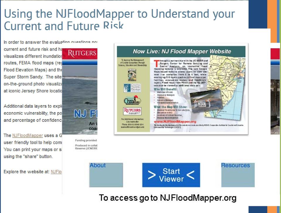
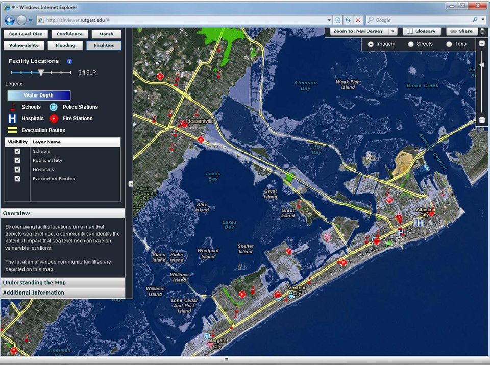
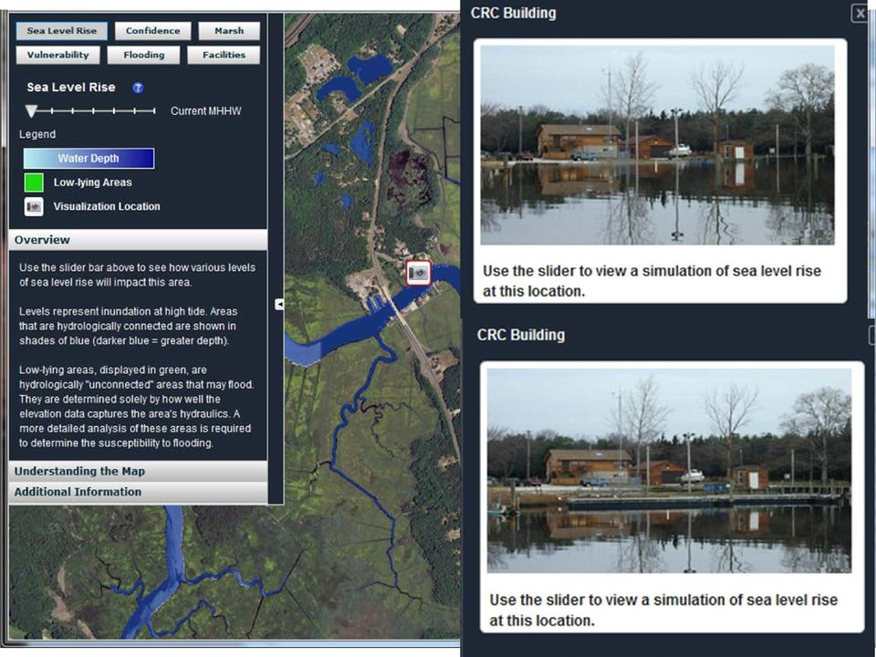
7 NJFloodMapper Goals: to broaden access to vital geospatial information with the goal of empowering a wide and diverse community of concerned parties interested in coastal management and conservation. Research Objectives: to examine how webbased geospatial decision-making tools can be developed and implemented to promote coastal resilience in the face of sea level rise and extreme storm events: Outcomes: Develop a focused web-based mapping application with an intuitive interface and gentle learning curve.

8 Applying a Instructional Systems Design Model Analyze Audience Design Product Develop Product Launch Product Evaluate Product & Process Front-end Evaluation (assess users needs & desires for improved decision making) Formative Evaluation (get feedback on design criteria, storyboards, prototypes, beta products, etc., as often as possible & is needed) Summative Evaluation (assess if products work & are useful)

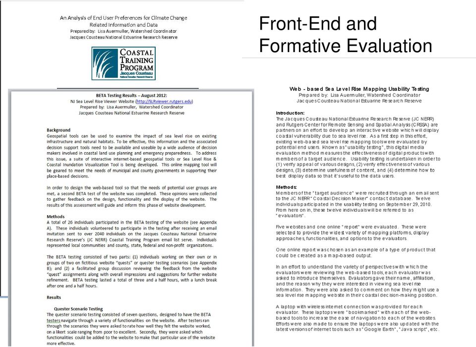
9 Front-End and Formative Evaluation
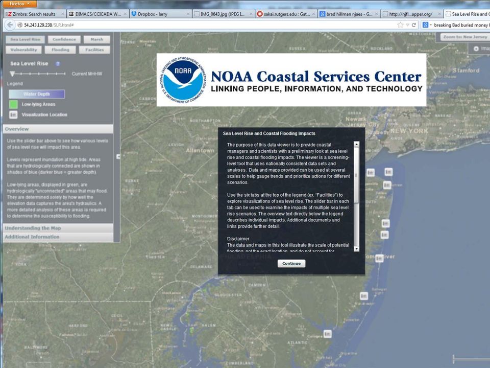
10 Leveraging federal assets for local application

11
12
13
14
15 FEMA Special Flood Hazard Areas (SFHAs)

16 NJFloodMapper: SFHA with Hurricane Sandy Surge extent

17 FEMA SFHAs under Sea Level Rise at 2050

18 Maintaining Green Infrastructure: Coastal Salt Marshes Marsh builds up vertically through accretion Marsh migrates horizontally Tidal Marsh Retreat Graphic from

19

20

21 Summative Evaluation How useful are these tools? How can they be improved?
22 Plan for the Future
23 Visualization & Information capture through map/graphics Visualize exposure & sensitivity Preparedness Assessment
24 NJAdapt Coastal Hazard Profiler
25 map-packs Municipal Profiles
26
27 Coastal Community Resiliency Progression Assess Evaluate Your Municipal Risks and Vulnerabilities Plan Utilize Getting to Resilience to Plan for the Future Implement Take Actions to Increase Municipal Preparedness
28 So Many Tools: which to use?
29 Closing Thoughts: WebGIS tools, such as NJFloodMapper, can provide access to critical place-based information on coastal flood exposure and potential vulnerability. Leveraging national-scale effort with locally-refined geospatial data and functionality is a good model. Providing a local scale municipal focus Adding local data and functionality requested by the community
30 Closing Thoughts: The user-centered design process was central to that elusive goal of virtual accessibility. Fostered connection to target audience. Promoted greater acceptance once tool was released. Proliferation of WEBGIS SLR tools can be confusing to the end-user community. Even with great WEBGIS tools, community level planning still needs a personal touch through in-thefield outreach and assistance
31 Key Websites: Coastal Flood Exposure Profiler Njadapt.org NJFlood Mapper: visualizing SLR NJFloodMapper.org Getting To Resilience: A Community Planning Evaluation Tool Prepareyourcommunitynj.org NJ Climate Adaptation Alliance Climatechange.rutgers.edu
Miami-Dade County Roadmap for Adapting to Coastal Risk
 Miami-Dade County Roadmap for Adapting to Coastal Risk Vulnerability Assessment & Planning Workshop Results & Recommendations Roadmap for Adapting to Coastal Risk Page 1 Introduction GreenPrint is Miami-Dade
NOAA Sentinel Site Program: San Francisco Bay Area Sentinel Site Cooperative
 NOAA Sentinel Site Program: San Francisco Bay Area Sentinel Site Cooperative Vision: Ensure a San Francisco Bay Area that is resilient to sea level rise through a strong partnership of federal, state,
NOAA COASTAL SERVICES CENTER Strategic Plan: 2010 to 2015
 NOAA COASTAL SERVICES CENTER Strategic Plan: 2010 to 2015 N a t i o n a l O c e a n i c a n d A t m o s p h e r i c A d m i n i s t r a t i o n ( N O A A ) C o a s t a l S e r v i c e s C e n t e r March
An Update on the Work of the Florida Catastrophic Storm Risk Management Center. Lorilee A. Medders, Ph.D. Director
 An Update on the Work of the Florida Catastrophic Storm Risk Management Center Lorilee A. Medders, Ph.D. Director Florida Hurricane Catastrophe Fund Workshop June 11, 2015 Buena Vista, Florida Section
Pete Slovinsky, Coastal Geologist, Maine Dept. of Agriculture, Conservation and Forestry
 MEGUG WINTER MEETING AGENDA FEB 2 ND, USM WISHCAMPER CENTER PORTLAND, ME 8:30 9:30am Registration and Poster Setup. Coffee, Tea, and Pastry served. 9:30 10am Opening Remarks, Announcements, and Updates
GULF COAST VULNERABILITY ASSESSMENT: AN APPROACH TO ASSESS KEY DRIVERS OF ECOLOGICAL CHANGE IN GULF OF MEXICO ECOSYSTEMS AND SPECIES
 GULF COAST VULNERABILITY ASSESSMENT: AN APPROACH TO ASSESS KEY DRIVERS OF ECOLOGICAL CHANGE IN GULF OF MEXICO ECOSYSTEMS AND SPECIES Amanda Watson NGI/GRI, Mississippi State University amandaw@gri.misstate.edu
Submitted to: Fellowship Coordinator NOAA Office of Coastal Management2234 South Hobson Avenue Charleston, SC 29405-2413.
 Tapping Crowd-Sourced Information to Improve Healthy Coastal Ecosystems and make New York Coastal Communities more Resilient: Expanding the New York Geographic Information Gateway (Gateway), a Tool for
Resolution XII.13. Wetlands and disaster risk reduction
 12 th Meeting of the Conference of the Parties to the Convention on Wetlands (Ramsar, Iran, 1971) Punta del Este, Uruguay, 1-9 June 2015 Resolution XII.13 Wetlands and disaster risk reduction 1. RECALLING
How To Use The Climate Ready Utilities Program
 Introduction to the Climate Resilience Evaluation & Awareness Tool Climate Ready Water Utilities Webinar Series Curt Baranowski, US EPA Jim Hawhee, Albemarle-Pamlico NEP February 27, 2013 Use your mouse
Future of our coasts: Potential for natural and hybrid infrastructure to enhance ecosystem and community resilience Ariana Sutton-Grier
 Future of our coasts: Potential for natural and hybrid infrastructure to enhance ecosystem and community resilience Ariana Sutton-Grier University of Maryland & National Oceanic and Atmospheric Administration
Eastern Connecticut Risk & Vulnerability Assessment Workshop
 Coastal Resilience New York and Connecticut A Tool for Coastal Planning in a Changing World Eastern Connecticut Risk & Vulnerability Assessment Workshop January 11, 2012 Waterford Town Hall - Auditorium
Subactivity: Habitat Conservation Program Element: National Wetlands Inventory
 HABITAT CONSERVATION FY 29 BUDGET JUSTIFICATION Subactivity: Habitat Conservation Program Element: National Wetlands Inventory National Wetlands Inventory ($) FTE 27 4,7 2 28 Enacted 5,255 2 Fixed Costs
Flood Damage Mitigation And Insurance Costs
 Flood Damage Mitigation And Insurance Costs Friday, September 25, 2015 at 7:00 PM Saturday, September 26, 2015 at 10:00 AM This presentation was prepared by the Town of South Bethany using Federal Funds
Tools from the US EPA s Climate Ready Water Utilities Initiative (CRWU) EPA Region 3 Conference Extreme Weather Events: Adapt, Mitigate, and Survive
 EPA Region 3 Conference Extreme Weather Events: Adapt, Mitigate, and Survive") Tools from the US EPA s Climate Ready Water Utilities Initiative (CRWU) EPA Region 3 Conference Extreme Weather Events: Adapt, Mitigate, and Survive May 9, 2013 1 Presentation Overview Background on EPA
Tools from the US EPA s Climate Ready Water Utilities Initiative (CRWU) EPA Region 3 Conference Extreme Weather Events: Adapt, Mitigate, and Survive May 9, 2013 1 Presentation Overview Background on EPA
New York Sea Grant Strategic Plan
 New York Sea Grant Strategic Plan Introduction and Process This is the new strategic plan for New York Sea Grant (NYSG) for the years 2010-2013 as requested by the National Sea Grant Office. This plan
Oregon. Climate Change Adaptation Framework
 Oregon Climate Change Adaptation Framework Oregon Environmental Quality Commission Climate Change Adaptation Framework Presentation at a glance: Purposes of the framework Participating agencies Climate
COASTAL RISK RAPID ASSESSMENT AND FIRST SCORE. MIAMI BEACH CITY HALL 1700 Convention Center Dr., Miami Beach, FL, 33139
 COASTAL RISK RAPID ASSESSMENT AND FIRST SCORE MIAMI BEACH CITY HALL 1700 Convention Center Dr., Miami Beach, FL, 33139 *THIS REPORT IS PROVIDED SUBJECT TO THE COASTAL RISK CONSULTING, LLC, PRINTED DISCLAIMERS
THE STRATEGIC PLAN OF THE HYDROMETEOROLOGICAL PREDICTION CENTER
 THE STRATEGIC PLAN OF THE HYDROMETEOROLOGICAL PREDICTION CENTER FISCAL YEARS 2012 2016 INTRODUCTION Over the next ten years, the National Weather Service (NWS) of the National Oceanic and Atmospheric Administration
Climate Ready Tools & Resources
 August 2, 2013 Mission Statement To provide the water sector (drinking water, wastewater, and stormwater utilities) with the practical tools, training, and technical assistance needed to adapt to climate
An Initial Assessment of the Impacts of Sea Level Rise to the California Coast
 An Initial Assessment of the Impacts of Sea Level Rise to the California Coast Photo by D. Revell 2/23/08 California Coastal Records Project Dr. David Revell and Matt Heberger, P.E. Dr. Peter Gleick, Bob
Association of State Flood Managers Annual Conference Wednesday, June 4, 2014
 Association of State Flood Managers Annual Conference Wednesday, June 4, 2014 Hillsborough County, In the Trenches Local Mitigation Eugene Henry, CFM, AICP Hazard Mitigation Manager Floodplain Administrator
Essex County, NJ. Preliminary Flood Insurance Study & Flood Insurance Rate Maps Release. FEMA Region 2 May 29, 2014
 Essex County, NJ Preliminary Flood Insurance Study & Flood Insurance Rate Maps Release FEMA Region 2 May 29, 2014 Agenda Introduction Review: Preliminary Work Maps (July 2013) Preliminary Flood Insurance
Federal Emergency Management Agency (FEMA) Preliminary Flood Insurance Rate Maps (FIRMs) and Preliminary Flood Insurance Study (FIS) for New York City
 Preliminary Flood Insurance Rate Maps (FIRMs) and Preliminary Flood Insurance Study (FIS) for New York City") March 10, 2014 Submitted electronically via http://www.nyc.gov Mayor s Office of Long Term Planning and Sustainability c/o Flood Map Comments 253 Broadway, 10th Floor New York, NY 10007 Federal Emergency
March 10, 2014 Submitted electronically via http://www.nyc.gov Mayor s Office of Long Term Planning and Sustainability c/o Flood Map Comments 253 Broadway, 10th Floor New York, NY 10007 Federal Emergency
Develop hazard mitigation policies and programs designed to reduce the impact of natural and human-caused hazards on people and property.
 6.0 Mitigation Strategy Introduction A mitigation strategy provides participating counties and municipalities in the H-GAC planning area with the basis for action. Based on the findings of the Risk Assessment
Climate Change Long Term Trends and their Implications for Emergency Management August 2011
 Climate Change Long Term Trends and their Implications for Emergency Management August 2011 Overview A significant amount of existing research indicates that the world s climate is changing. Emergency
Sea Level Rise Adaptation in the Public Sector: Challenges, Solutions, and Opportunities
 White Paper Sea Level Rise Adaptation in the Public Sector: Challenges, Solutions, and Opportunities As climate change progresses, the relentless march of sea level rise (SLR) presents an array of challenges
THE WHITE HOUSE Office of Science and Technology Policy. FOR IMMEDIATE RELEASE December 9, 2014
 THE WHITE HOUSE Office of Science and Technology Policy FOR IMMEDIATE RELEASE December 9, 2014 FACT SHEET: Harnessing Climate Data to Boost Ecosystem & Water Resilience We're going to have to all work
San Francisco Bay Margin Conservation Decision Support System (DSS)
") San Francisco Bay Margin Conservation Decision Support System (DSS) Presented by Brian Fulfrost1, MS David Thomson2, MS 1 Brian Fulfrost and Associates 2 San Francisco Bay Bird Observatory Transitional
San Francisco Bay Margin Conservation Decision Support System (DSS) Presented by Brian Fulfrost1, MS David Thomson2, MS 1 Brian Fulfrost and Associates 2 San Francisco Bay Bird Observatory Transitional
Translating Dreams into Reality:
 Translating Dreams into Reality: Assessing risk in an unpredictable world Surge from Hurricane Sandy crashes over a sea wall in Kennebunk, Maine on October 29, 2012 Judy Gates, Director, Environmental
Figure 1. USGS Coastal Change Hazards home page (http://marine.usgs.gov/kb/ views/cch/). This topical node of the USGS Coastal and Marine Knowledge
. This topical node of the USGS Coastal and Marine Knowledge") THE COASTAL CHANGE HAZARDS NODE OF THE U.S. GEOLOGICAL SURVEY (USGS) COASTAL AND MARINE KNOWLEDGE BANK: ONLINE SCIENTIFIC RESOURCES FOR COASTAL ZONE MANAGEMENT AND DISASTER PREPAREDNESS M. Dennis Krohn,
THE COASTAL CHANGE HAZARDS NODE OF THE U.S. GEOLOGICAL SURVEY (USGS) COASTAL AND MARINE KNOWLEDGE BANK: ONLINE SCIENTIFIC RESOURCES FOR COASTAL ZONE MANAGEMENT AND DISASTER PREPAREDNESS M. Dennis Krohn,
Post-Sandy Municipal Needs Assessment for Long-Term Recovery and Resiliency Planning EXECUTIVE SUMMARY
 Post-Sandy Municipal Needs Assessment for Long-Term Recovery and Resiliency Planning EXECUTIVE SUMMARY Prepared by Nathaly Agosto Filión, Resiliency Manager for the New Jersey Resiliency Network, a program
2015 -- H 5478 S T A T E O F R H O D E I S L A N D
 LC00 01 -- H S T A T E O F R H O D E I S L A N D IN GENERAL ASSEMBLY JANUARY SESSION, A.D. 01 H O U S E R E S O L U T I O N CREATING THE RHODE ISLAND HOUSE COMMISSION ON ECONOMIC RISK DUE TO FLOODING AND
Hoboken Resiliency & Readiness Plan
 Hoboken Resiliency & Readiness Plan Layers of Protection Mayor Dawn Zimmer Challenge: Hoboken was once an island outcrop. Surrounding tidal marshes were filled in, but City remains vulnerable to storm
American Planning Association
 American Planning Association Planning for Post-Disaster Recovery Session 2 Moderator: James Schwab, AICP, APA Speakers: Laurie A. Johnson, AICP, Laurie Johnson Consulting Lincoln Walther, FAICP, CSA Ocean
EPA Trends for wastewater Treatment in California - 2011
 EPA S TECHNOLOGY NEEDS FOR THE WATER AND WASTEWATER INDUSTRY Nancy Stoner Acting Assistant Administrator U.S. EPA Office of Water International Emerging Technology Symposium Arlington, VA April 23rd, 2014
Using Insurance Catastrophe Models to Investigate the Economics of Climate Change Impacts and Adaptation
 Using Insurance Catastrophe Models to Investigate the Economics of Climate Change Impacts and Adaptation Dr Nicola Patmore Senior Research Analyst Risk Management Solutions (RMS) Bringing Science to the
Earth, Wind and Fire: Just Add Water and Stir Vigorously
 Earth, Wind and Fire: Just Add Water and Stir Vigorously While preventing a natural disaster such as floods and drought is very difficult, measures such as good planning which includes mitigation measures
United States Postal Service Climate Change Adaptation Plan
 United States Postal Service Climate Change Adaptation Plan Version: June 29, 2012 USPS Climate Change Adaptation Plan 1. Introduction...2 2. Policy Framework...3 Vision & Goals...3 Objectives...3 Responsible
Leveraging Resources for Financing, Implementing, and Sustaining Climate Change Adaptation and Resiliency
 Leveraging Resources for Financing, Implementing, and Sustaining Climate Change Adaptation and Resiliency August 20, 2014 California Adaptation Forum Karen Kubick, PE Sewer System Improvement Program Director
U.S. Fish and Wildlife Service will invest $15 million for post-sandy cleanup and marsh restoration on Long Island
 For Immediate Release: Wednesday, November 6, 2013 For further information: Michelle Potter, refuge manager, 631/286-0485 ext. 2112, Michelle_Potter@fws.gov Tom Sturm, public affairs specialist, 413/253-8339,
Town of Chatham Department of Community Development
 Town of Chatham Department of Community Development TOWN ANNEX 261 GEORGE RYDER ROAD 02633 CHATHAM, MA TELEPHONE (508) 945-5168 FAX (508) 945-5163 FEMA FLOOD MAP UPDATE & PROPOSED ZONING BYLAW AMENDMENT
Coastal Drought and Water Supply in the Southeast
 Coastal Drought and Water Supply in the Southeast Jessica C. Whitehead, PhD. S.C. Sea Grant Consortium/N.C. Sea Grant 2010 Land Grant and Sea Grant National Water Conference 22 February 2010 Outline Coastal
Recommendation: I will update the Board as necessary. Recommendation: No further action is necessary.
 Town Administrator s Report Board of Selectmen s Meeting of June 1, 2015 Report covers from May 16, 2015 to May 29, 2015 Items requiring Board vote or discussion are noted with an asterisk (*) A. Town
Joint Polar Satellite System (JPSS)
") Joint Polar Satellite System (JPSS) John Furgerson, User Liaison Joint Polar Satellite System National Environmental Satellite, Data, and Information Service National Oceanic and Atmospheric Administration
Joint Polar Satellite System (JPSS) John Furgerson, User Liaison Joint Polar Satellite System National Environmental Satellite, Data, and Information Service National Oceanic and Atmospheric Administration
A Proposal to: National Oceanic and Atmospheric Administration, Office of Coastal Management 2016 Coastal Management Fellowship Program
 A Proposal to: National Oceanic and Atmospheric Administration, Office of Coastal Management 2016 Coastal Management Fellowship Program Submitted by: The Nature Conservancy Project Title: Strategic Opportunities
The Local Government Self- Assessment Tool. Taking stock, celebrating achievements and planning for DRR in Addis Ababa
 The Local Government Self- Assessment Tool Taking stock, celebrating achievements and planning for DRR in Addis Ababa Background Throughout history, disaster events have disrupted urban life. With more
Coastal Science Serving North Carolina
 1 Coastal Science Serving North Carolina Susan N. White, Executive Director NORTH CAROLINA SEA GRANT S VISION North Carolina Sea Grant will, in the 21st Century, serve as a leader in addressing the state's
1. GENERAL ADVISORY BASE FLOOD ELEVATION (ABFE) QUESTIONS
 QUESTIONS") INTRODUCTION As communities begin to recover from the devastating effects of Hurricane Sandy, it is important to recognize lessons learned and to employ mitigation actions that ensure structures are rebuilt
INTRODUCTION As communities begin to recover from the devastating effects of Hurricane Sandy, it is important to recognize lessons learned and to employ mitigation actions that ensure structures are rebuilt
Policy & Management Applications of Blue Carbon. fact SHEET
 Policy & Management Applications of Blue Carbon fact SHEET Policy & Management Applications of Blue Carbon Coastal Blue Carbon - An Important Wetland Ecosystem Service Coastal Blue Carbon refers to the
Integrated Water Resources Science and Services. National Water Center
 TOO MUCH POOR QUALITY TOO LITTLE Integrated Water Resources Science and Services and the National Water Center Partnering to Address America s Water Resources Information Needs Mary G. Mullusky National
Empowering State and Local Governments To Redirect Decision-Making to Achieve Resiliency
 Empowering State and Local Governments To Redirect Decision-Making to Achieve Resiliency Recommendations for New Jersey Irene, the October 2011 snowstorm, and most recently Superstorm Sandy were a wake-up
THE WHITE HOUSE Office of the Press Secretary. FACT SHEET: 16 U.S. Communities Recognized as Climate Action Champions for Leadership on Climate Change
 FOR IMMEDIATE RELEASE December 3, 2014 THE WHITE HOUSE Office of the Press Secretary FACT SHEET: 16 U.S. Communities Recognized as Climate Action Champions for Leadership on Climate Change From deep droughts
Town of Hingham. Changes to Flood Insurance Rate Maps and Flood Insurance Costs Frequently Asked Questions
 Town of Hingham 1. What is a floodplain? Changes to Flood Insurance Rate Maps and Flood Insurance Costs Frequently Asked Questions A floodplain is an area of land where water collects, pools and flows
Monmouth County Preliminary Flood Insurance Study and Flood Insurance Rate Maps Release
 Monmouth County Preliminary Flood Insurance Study and Flood Insurance Rate Maps Release Thomas Song, Program Specialist FEMA Region 2 January 31, 2014 Agenda Introduction Review: Preliminary Work Maps
Hurricane Sandy: The Challenges and Opportunities to Link Disaster Management and Climate Change Adaptation*
 Hurricane Sandy: The Challenges and Opportunities to Link Disaster Management and Climate Change Adaptation* Gavin Smith, Ph.D. Associate Research Professor Department of City and Regional Planning University
Case Study 3 From vulnerability assessments to public policy in Cartagena, Colombia
 Case Study 3 From vulnerability assessments to public policy in Cartagena, Colombia Claudia Martinez, CDKN Colombia Country Engagement Leader & Green Growth Advisor, Government of Colombia Climate and
FLOOD HAZARD IN THE URBAN ENVIRONMENT: IMPLICATIONS FOR DEVELOPERS, DESIGNERS, AND ATTORNEYS
 FLOOD HAZARD IN THE URBAN ENVIRONMENT: IMPLICATIONS FOR DEVELOPERS, DESIGNERS, AND ATTORNEYS PRESENTED BY: CHAD W. COX, P.E. DANIEL C. STAPLETON, P.E. BOSTON, MA JAN. 24, 2014 PRESENTATION Flood Vulnerability
2014 Delaware Ordinance Workshops and assistance. Higher Standards identified by Delaware Senate Bill 64
 INCREASING FLOOD RESILIENCY THROUGHT IMPROVED FLOOD CODES Michael S. Powell, Hazard Mitigation Program Manager, DNREC New Coastal Study and Floodplain Maps 2014 Delaware Ordinance Workshops and assistance
Why should communities invest in resiliency? What are the steps communities can take to become more resilient?
 Community Preparedness for Flood Resiliency Nina Peek, AICP New York Planning Federation Board of Directors Senior Technical Director AKRF, Inc. Focus of Today s Presentation Why should communities invest
Creating a More Resilient Future. Friday 30 May, 11:00 to 12:30, Rooms S29-31
 Creating a More Resilient Future Friday 30 May, 11:00 to 12:30, Rooms S29-31 Empowering Resilience With GIS ICLEI Smart Resilient Cities Strategic Use of Spatial Systems Jim Geringer, Esri Former Governor,
Building Caribbean GeoNode Platform in Support of Climate Risk Management Jacob Opadeyi, PhD
 Building Caribbean GeoNode Platform in Support of Climate Risk Management Jacob Opadeyi, PhD Our Highly Vulnerable Region Housing developments on drainage channels and steep slopes Unapproved development
Snapshots: Resilient Lands and Waters Initiative
 Snapshots: Resilient Lands and Waters Initiative Introduction... 2 Lakes Huron and Erie Coastal Wetlands (Saginaw Bay (MI) to Maumee River (OH/IN))... 3 Puget Sound/Snohomish River Watershed... 4 Southwest
Constructing Urban Vulnerability Index for Major U.S. Cities
 CREATE Research Archive Research Project Summaries 2009 Constructing Urban Vulnerability Index for Major U.S. Cities Haydar Kurban Howard University, HKURBAN@HOWARD.EDU Mika Kato Howard University, mkato@howard.edu
LOCAL COASTAL PROGRAM PLANNING GRANTS JOINT APPLICATION ANNOUNCEMENT & INSTRUCTIONS APRIL 23, 2014
 LOCAL COASTAL PROGRAM PLANNING GRANTS JOINT APPLICATION ANNOUNCEMENT & INSTRUCTIONS APRIL 23, 2014 The State of California is pleased to announce grant funding for FY14-15 to support local governments
Disaster Risk Reduction and Building Resilience to Climate Change Impacts
 Disaster Risk Reduction and Building Resilience to Climate Change Impacts Luna Abu-Swaireh (abu-swaireh@un.org) May 2015 United Nations Office for Disaster Risk Reduction (UNISDR) Droughts Floods Storms
Presentation Program Outline
 Presentation Program Outline IRWM Program Background San Diego IRWM Planning 2013 IRWM Update Integrated Flood Management Flood Management Planning Study IRWM Program Background What is IRWM? Collaborative
They Had the Facts, Why Didn t They Act?
 They Had the Facts, Why Didn t They Act? Understanding and Improving Public Response to National Weather Service s Coastal Flood Forecasts Rachel Hogan Carr October 15, 2014 Nurture Nature Center is a
Flood Risk and Visual Communication Techniques
 FLOOD RISK AND UNCERTAINTY Assessing the National Weather Service s Flood Forecast and Warning Tools Rachel Hogan Carr Delaware River Basin Commission December 3, 2014 Nurture Nature Center is a non-profit
Empowering Local Clean Energy Action FEDERAL POLICY AGENDA FOR 2011
 Empowering Local Clean Energy Action FEDERAL POLICY AGENDA FOR 2011 L ocal government leadership is essential for America to achieve energy independence, renew economic prosperity and protect the environment.
Submission by the United States of America to the UN Framework Convention on Climate Change Communication of U.S. Adaptation Priorities May 29, 2015
 Submission by the United States of America to the UN Framework Convention on Climate Change Communication of U.S. Adaptation Priorities May 29, 2015 Adaptation is a challenge for all Parties. In addition
Norfolk Flooding Strategy Update. Presentation to Norfolk City Council March 27, 2012
 Norfolk Flooding Strategy Update Presentation to Norfolk City Council March 27, 2012 Presentation Overview The purpose of this presentation is to provide City Council an update on activities carried out
Sea Level Rise and Coastal Flood Web Tools Comparison Matrix - Oregon GENERAL
 Geographic Scope Organization/Sponsor Link Geographic extent the tool defines or covers (i.e. national, statewide, county ) The organization and/or sponsor of the mapping tool. The URL or link where the
Engaging and Empowering Whole Community Disaster Resilience
 Engaging and Empowering Whole Community Disaster Resilience Paula Scalingi, Executive Director Bay Area Center for Regional Disaster Resilience Dutch Miracle Resilience Conference November 1, 2013 Where
Malcolm L. Spaulding Professor Emeritus, Ocean Engineering University of Rhode Island Narragansett, RI 02881
 Malcolm L. Spaulding Professor Emeritus, Ocean Engineering University of Rhode Island Narragansett, RI 02881 USACE Coastal and Hydraulics Laboratory(CHL) Data Infrastructure Workshop January 23, 2014 Overview
Whole Community Concept Integration into National Disaster Preparedness Training Center University of Hawaii
 Whole Community Concept Integration into National Disaster Preparedness Training Center University of Hawaii Established in 2007 under H.R. 1, Implementing Recommendations of the 9/11 Commission Act of
Ariana Sutton-Grier, Holly Bamford & Kateryna Wowk University of Maryland and National Oceanic and Atmospheric Administration
 Future of our coasts: Potential for natural and hybrid infrastructure Ariana Sutton-Grier, Holly Bamford & Kateryna Wowk University of Maryland and National Oceanic and Atmospheric Administration Green
Flooding in San Francisco Bay: Risks and Opportunities
 Flooding in San Francisco Bay: Risks and Opportunities Photo Judy Irving Pelican Media Authors Jeffrey Mount, Saracino & Mount LLC Jeremy Lowe, ESA PWA Flooding in San Francisco Bay: Risks and Opportunities
NOAA NATIONAL SEA GRANT COLLEGE PROGRAM 2014 2017 STRATEGIC PLAN
 NOAA NATIONAL SEA GRANT COLLEGE PROGRAM 2014 2017 STRATEGIC PLAN Sustaining our nation s ocean, coastal and Great Lakes resources through university based research, communications, education, extension
Oregon Pre-Disaster Mitigation Program Plan Update Training Manual
 FEMA Oregon Pre-Disaster Mitigation Program Plan Update Training Manual Prepared by: Oregon Partnership for Disaster Resilience OPDR FEMA OPDR FEMA OPDR 2010, University of Oregon s Community Service Center
Flood Risk Management
 Flood Risk Management Value of Flood Risk Management Every year floods sweep through communities across the United States taking lives, destroying property, shutting down businesses, harming the environment
Flood Risk Management
 Flood Risk Management Value of Flood Risk Management Value to Individuals and Communities Every year floods sweep through communities across the United States taking lives, destroying property, shutting
ART Vulnerability and Risk Assessment Report September 2012 Appendix C. ART GIS Exposure Analysis
 Adapting to Rising Tides GIS Exposure Analysis The aim of this appendix is to familiarize the reader with the data and methodology that was used to conduct an analysis of shoreline and community asset
POST-DISASTER REDEVELOPMENT PLANNING
 TABLE OF CONTENTS POST-DISASTER REDEVELOPMENT PLANNING Addressing Adaptation During Long-term Recovery Florida Department of Economic Opportunity Florida Division of Emergency Management page ii This report
New Jersey s Lower Hudson River Waterfront 25 Years of Construction: Challenges for the Next 25 Post-Sandy Era. Oct. 8, 2013
 New Jersey s Lower Hudson River Waterfront 25 Years of Construction: Challenges for the Next 25 Post-Sandy Era Oct. 8, 2013 Sponsored by Hudson River Waterfront Conservancy of New Jersey and Stevens Institute
THE BAY OF KIEL CLIMATE ALLIANCE
 ADAPTATION TO CLIMATE CHANGE IN MOUNTAIN & COASTAL AREAS: A TRANSATLANTIC DIALOGUE APRIL 16 19, 2013, Climate Service Center, Hamburg, Germany Experience of Adaptation Activities in THE BAY OF KIEL CLIMATE
James City County and Williamsburg Open House Meeting
 James City County and Williamsburg Open House Meeting What the New Preliminary Flood Insurance Rate Maps (FIRMs) Mean for Your Community and for You as a Property Owner August 13, 2014 1 Today s Open House
Translating Science Into Practice
 Translating Science Into Practice Climate Change Carbon Cycle Translating Science Into Practice Tools and interfaces that aid in turning the data into useable and accessible information 1 Translating Science
Mariana Leckner, Ph.D., Professor, American Military University Thomas O. Herrington, Ph.D. Associate Professor, Stevens Institute of Technology
 Mariana Leckner, Ph.D., Professor, American Military University Thomas O. Herrington, Ph.D. Associate Professor, Stevens Institute of Technology National Hydrologic Warning Council Training Conference
Floodplain Management - What You Need to Know
 The National Program and the Community Rating System Shannon Hulst, Wetlands Watch March 26, 2014 What We are Doing with the CRS Partnership with VIMS & VCPC (W&M Law School) VCPC working with DCR to ensure
Accelerating Cross-Sectoral Collaboration on Data in Climate, Education and Health
 Accelerating Cross-Sectoral Collaboration on Data in Climate, Education and Health A Workshop on Data Sharing and Emerging Data Collaboratives U.S. General Services Administration Building 1800 F Street,
In Coastal Virginia, flooding
 Fall 2012, Vol. 7, No. 2 In Coastal Virginia, flooding has been an on-going issue. Flooding is caused by precipitation events, high tides or storm surge. Although flooding has occurred throughout recorded
Colorado s Long Term Recovery and Resiliency. Together. A stronger Colorado.
 Colorado s Long Term Recovery and Resiliency Together. A stronger Colorado. What is Resiliency? His continued dedication to the emergency response and preparation of the citizens of the San Luis Valley
Vulnerable Populations to Climate Change in New Jersey
 Vulnerable Populations to Climate Change in New Jersey December 2013 UPDATED February 2014 Kelly M. Bickers Climate Fellow, Clean Air-Cool Planet Master of City and Regional Planning Candidate, 2014 Edward
Reality Check: Climate Adaptation on the Ground in Miami-Dade County
 Reality Check: Climate Adaptation on the Ground in Miami-Dade County 1st World Congress on Cities and Adaptation to Climate Change Bonn, Germany Saturday, May 28th 30th, 2010 1:30 PM 3:30 PM Honorable
Planning Policy and Guidance on Flooding and Coastal Erosion
 Planning Policy and Guidance on Flooding and Coastal Erosion James Hooker (MRTPI) Senior Planning Manager Welsh Government RTPI Cymru - Water and Flooding Seminar Tuesday 20 th November 2012 Overview
Flood Emergency Response Planning: How to Protect Your Business from a Natural Disaster RIC005
 Flood Emergency Response Planning: How to Protect Your Business from a Natural Disaster RIC005 Speakers: Tom Chan, CEO, Global Risk Miyamoto Greg Bates, Principal, Global Risk Consultants Learning Objectives
Visual Integration of Compound Events. A presentation to the Climate Compact of Southeast Florida
 Visual Integration of Compound Events A presentation to the Climate Compact of Southeast Florida What is the Compact? Agreement between Broward, Miami-Dade, Monroe, and Palm Beach County Commissions (set
New Brunswick s Flood Risk Reduction Strategy. Province of New Brunswick PO 6000, Fredericton NB E3B 5H1. www.gnb.ca
 New Brunswick s Flood Risk Reduction Strategy i New Brunswick s Flood Risk Reduction Strategy Province of New Brunswick PO 6000, Fredericton NB E3B 5H1 2014 www.gnb.ca ISBN 978-1-4605-0533-5 (print edition)
LAUNCH OF THE NEW JERSEY FLOOD MAPPER
 WINTER/SPRING 2014 WWW.JCNERR.ORG QUARTERLY NEWSLETTER OF THE JACQUES COUS TEAU NATIONAL ESTUARINE RESEARCH RESERVE LAUNCH OF THE NEW JERSEY FLOOD MAPPER Jacques Cousteau National Estuarine Research Reserve
DEPARTMENT OF COMMERCE
 DEPARTMENT OF COMMERCE Funding Highlights: Provides $8.8 billion in base discretionary funding for the Department of Commerce to create the conditions for economic growth by promoting trade and investment,