Mariana Leckner, Ph.D., Professor, American Military University Thomas O. Herrington, Ph.D. Associate Professor, Stevens Institute of Technology
|
|
|
- Sabina Gardner
- 8 years ago
- Views:
Transcription

1 Mariana Leckner, Ph.D., Professor, American Military University Thomas O. Herrington, Ph.D. Associate Professor, Stevens Institute of Technology National Hydrologic Warning Council Training Conference and Exposition San Diego, CA May 11, 2011

2 Shrewsbury River, New Jersey John Frederick Kensett, 1859

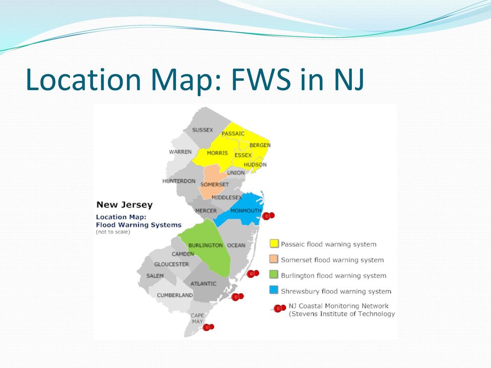
3 Introduction: An Independent System Flood warning system for the Shrewsbury and Navesink Rivers communities /county Repetitive loss communities Built-out communities Tidal and inland flooding Others in NJ: Passaic Basin, Somerset County, Burlington County, CMN Gauge locations, SRFWS (not to scale): Source:
: Source: http://hudson.dl.stevens-tech.")

4 Location Map: FWS in NJ
5 Introduction: An Independent System Decreasing Federal and state budgets/systems StormReady Oceanport was the catalyst Pooled resources for Planning Funding O&M Research Mitigation Shrewsbury River at Route 36 (Photo: M. Leckner)

6 System Stakeholders Monmouth County OEM Municipalities Highlands Little Silver Long Branch Middletown Monmouth Beach Oceanport Rumson Sea Bright Coastal Monmouth County 1992 (Photo: M. Leckner)

7 System Partners Academic Partners Monmouth University Stevens Institute of Technology and the rest Private Sector Leckner Consulting, LLC Jonach Electronics Invited Agencies NJOEM NWS NJ State Climatologist (NJ WxNet) USGS Coastal Monmouth County 1992 (Photo: M. Leckner)
 USGS Coastal Monmouth County 1992")
8 Flood Hazard Summary Nor easter Inland Rainfall Tidal Tropical Systems Category 1 Hurricane Storm Surge Map, SRFWS Communities. Source: MCOEM

9 Sandy Hook Water Level Trends

10 Historical Flood Heights/Categories Flood category Height (feet) * Location Minor flooding Sea Bright, Monmouth Beach, Long Branch, Rumson, Highlands Moderate Flooding Little Silver, Oceanport, Sandy Hook 96, 98, 00, 10 March 2010 flooding Major Flooding > 5.9 Sandy Hook, region 91, 92, 93 *NAVD88

11 System Summary Purpose Monitoring Alert Data collection Warning (goal) Gooseneck Bridge gauge. Photo: Capt. M. Baldanza

12 System Summary County/State Bridges Weather Stations with Tide Monmouth County Gooseneck Bridge Monmouth County Rumson-Sea Bright Bridge Monmouth County Oceanic Bridge Remote Tide Station State Highway 36 Bridge - Highlands Monmouth County Patten Ave Bridge Photo: Monmouth County PIO

13 System Specifications Installed in 2010 Five gauges High Sierra Electronics Model 3206 Self-contained, battery-powered Radar sensors to measure water levels (NAVD88) Regular maintenance NWS frequency
 Regular maintenance NWS")
14 System Specifications Receiver/Decoder Monmouth University, Urban Coast Institute Website Stevens Institute of Technology, The Center for Maritime Systems System Management Monmouth County OEM Operations All stakeholders

15 Gauge locations, SRFWS (not to scale). Source:

16 Datum Selection: NAVD88 The case for MLLW NWS Socioeconomic usage The case for NAVD88 National Flood Insurance Program Maps GIS work About 2.8 feet above MLLW at Sandy Hook, about 2.2 at Sea Bright Why the controversy? Communication with the public

17 Nearest gauges NOS Sandy Hook USGS Sea Bright Route 36 Bridge, Highlands, NJ (Photo: M. Leckner)

 Source: http://tidesandcurrents.noaa.gov/data_menu.shtml?")
18 Sandy Hook Datum Elevations View of Sandy Hook, NJ (Photo: M. Leckner) Source: Sandy Hook, NJ&type=Datums

19 USGS Gauge at Sea Bright Sea Bright, 3.3 miles south of Sandy Hook Bay Datum NAVD 1988 MLLW is feet Max on record: 4.75 feet (April 2007) Maximum estimated (1992): around 7.3 feet
 Maximum estimated (1992):")
20 Website
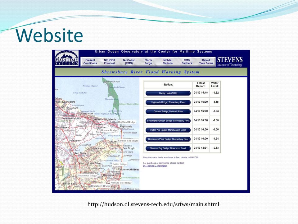
21 Website: Time-Series Interface

22 Website: Time-Series Interface
23 Gooseneck Bridge, April 16, 2011 By 9:45 PM approximately 4.1 feet of water (NAVD88) for selected locations in Oceanport, NJ (cool maps, no permissions!) Moderate flooding.
24 Current Issue: How high s the water? Benchmark for alerts and warnings System operation: 1 year complete NOAA tide station guidelines 19 years ( primary ) 1 year ( secondary ) less than 1 year ( tertiary ) Pressure to provide water levels: still water, MLLW, MHHW Alerts Warnings Value-added product
25 Determining Water Levels Preliminary data in progress (Stevens Institute of Technology, Monmouth University) Year 1 data preliminary Reporting sheets Critical juncture for the project
26 Key to progress: Collaboration Communities and County OEM/PD Public works Academic Research Partners Website Data Research
27 Summary System is functioning well Website is effective Needs: Preliminary water level calculations Regular community reporting Flood stage determinations Funding (Base Maps) Community Product: Identification of water levels for emergency management decision-making

28 Thank you! Comments &Questions? Mariana Leckner, Ph.D. Professor, American Military University Thomas O. Herrington Associate Professor, Stevens Institute of Technology
FLOOD STUDY Monmouth County, NJ. FEMA REGION II July 13, 2011 14:00
 FLOOD STUDY Monmouth County, NJ FEMA REGION II July 13, 2011 14:00 Agenda Introductions FEMA Strategic Plan & Risk Mapping, Assessment, and Planning (Risk MAP) Goals Risk MAP Program Overview Meeting Objectives
Environmental Data Services for Delaware:
 Environmental Data Services for Delaware: Serving Emergency Responders, Planners, and Researchers Network Delaware Day November 6, 2013 Overview Operational Data Services More than just research DEOS and
Jurisdictional Boundaries. And. Establishment of Mean Low Water
 Jurisdictional Boundaries And Establishment of 28.2-1202. Rights of owners to extend to mean low-water mark. A. The limits or bounds of the tracts of land lying on the bays, rivers, creeks and shores within
http://www.nj.gov/dep/shoreprotection/storm.htmhris TUCKER
 COASTAL STORM SURVEY NEW JERSEY DEPARTMENT OF ENVIRONMENTAL PROTECTION BUREAU OF COASTAL ENGINEERING - TOMS RIVER NJ 12:00 P.M. TUESDAY, MARCH 1, 2005 NEW JERSEY COASTLINE INCLUDING RARITAN AND DELAWARE
Vulnerability of Major Wastewater Facilities to Flooding from Sea-Level Rise. July 2008
 Vulnerability of Major Wastewater Facilities to Flooding from Sea-Level Rise July 2008 King County's Wastewater Treatment Division maintains 77 major facilities, 40 of which are situated adjacent to tidally
HAZUS 2014. 7 th Annual Conference
 HAZUS 2014 7 th Annual Conference HAZUS Comparison of Storm Surge Levels from Different Hurricanes to the Newest SLOSH Models for Berkeley, Charleston, & Dorchester Counties Along the SC Coastline. Charlie
Habitat for Humanity in Monmouth County Application for Sandy Related Home Repairs
 Habitat for Humanity in Monmouth County Application for Sandy Related Home Repairs Habitat for Humanity in Monmouth County (HFHMC) is willing to help with home repairs resulting from Hurricane Sandy. For
Storm tide is the water level rise during a storm due to the combination of storm surge and the astronomical tide.
 INTRODUCTION TO STORM SURGE Introduction to Storm Surge BOLIVAR PENINSULA IN TEXAS AFTER HURRICANE IKE (2008) What is Storm Surge? Inland Extent Storm surge can penetrate well inland from the coastline.
CRS 610 Ventura County Flood Warning System Website
 CRS 610 Ventura County Flood Warning System Website Purpose This document gives instructions and a description of the information available via the Ventura County Watershed Protection District s (VCWPD)
Weather Briefing for Southeast Texas October 24 th, 2015
 Weather Briefing for Southeast Texas October 24 th, 2015 Dangerous Flash Flood Event Saturday through Sunday 8:16 AM Overview Ongoing: record deep moisture in place, elevated seas, rip currents, high surf,
Hurricanes and Storm Surge www.hcfcd.org/tropicalweather
 Hurricanes and Storm Surge www.hcfcd.org High-level winds fl ow outward Strong surface winds spiral inward EYE Calm, sometimes cloudfree, sinking air Air sinks in calm area at the storm s eye THUNDERSTORMS
Storm tide is the water level rise during a storm due to the combination of storm surge and the astronomical tide.
 INTRODUCTION TO STORM SURGE Introduction to Storm Surge National Hurricane Center Storm Surge Unit BOLIVAR PENINSULA IN TEXAS AFTER HURRICANE IKE (2008) What is Storm Surge? Inland Extent Storm surge can
Sea Level Change. Miami-Dade Sea Level Rise Task Force
 Sea Level Change and LongProgram Range Everglades Restoration Climate Water Resources Planning for Florida Change Application Concerns of USACE andguidance Draft Sea Level on Sea Rise Level Planning Change
Department of Commerce National Oceanic & Atmospheric Administration National Weather Service
 Department of Commerce National Oceanic & Atmospheric Administration National Weather Service NATIONAL WEATHER SERVICE WESTERN REGION SUPPLEMENT 17-2003 APPLICABLE TO NWSI 10-701 MARCH 16, 2015 Operations
TROPICAL STORM ALLISON. Prepared by: John P. Ivey, PE, CFM Halff Associates, Inc. ASCE
 TROPICAL STORM ALLISON June 5-9, 5 2001 Prepared by: John P. Ivey, PE, CFM Halff Associates, Inc. ASCE Spring 2002 Meeting Arlington, Texas March 27-30, 2002 Tropical Storm Allison (TSA) The most extensive
Federal Emergency Management Agency (FEMA) Preliminary Flood Insurance Rate Maps (FIRMs) and Preliminary Flood Insurance Study (FIS) for New York City
 Preliminary Flood Insurance Rate Maps (FIRMs) and Preliminary Flood Insurance Study (FIS) for New York City") March 10, 2014 Submitted electronically via http://www.nyc.gov Mayor s Office of Long Term Planning and Sustainability c/o Flood Map Comments 253 Broadway, 10th Floor New York, NY 10007 Federal Emergency
March 10, 2014 Submitted electronically via http://www.nyc.gov Mayor s Office of Long Term Planning and Sustainability c/o Flood Map Comments 253 Broadway, 10th Floor New York, NY 10007 Federal Emergency
EPA s Climate Resilience Evaluation and Awareness Tool (CREAT): A Case Study
: A Case Study") EPA s Climate Resilience Evaluation and Awareness Tool (CREAT): A Case Study South Monmouth Regional Sewerage Authority (SMRSA) Serves 9 Townships 9.1 MGD Wastewater Treatment Plant 11 pump stations 11.
EPA s Climate Resilience Evaluation and Awareness Tool (CREAT): A Case Study South Monmouth Regional Sewerage Authority (SMRSA) Serves 9 Townships 9.1 MGD Wastewater Treatment Plant 11 pump stations 11.
NEW JERSEY E-GOVERNMENT: BEST PRACTICES IN MOMOUTH COUNTY
 Please attribute this information to: Monmouth University Polling Institute and Public Policy Graduate Program West Long Branch, NJ 07764 www.monmouth.edu/polling For immediate release: Tuesday, May 10,
How To Prepare For A Flood In Hampshire
 Chapter 6. Emergency Services Emergency services measures protect people during and after a flood. Locally, these measures are coordinated by the Huntsville-Madison County Emergency Management Agency.
Lower Raritan Watershed Management Area Stormwater & Flooding Subcommittee Strategy Worksheet LRSW-S3C1
 Strategy Name: Reduce Existing Potential for Flood Damages LRSW-S3C1. Develop and implement a program to: Minimize flood damages through the use of structural measures. Minimize flood damages through the
Improved Warnings for Natural Hazards: A Prototype System for Southern California
 Improved Warnings for Natural Hazards: A Prototype System for Southern California Yehuda Bock Research Geodesist Scripps Institution of Oceanography University of California San Diego, La Jolla, Calif.
Essex County, NJ. Preliminary Flood Insurance Study & Flood Insurance Rate Maps Release. FEMA Region 2 May 29, 2014
 Essex County, NJ Preliminary Flood Insurance Study & Flood Insurance Rate Maps Release FEMA Region 2 May 29, 2014 Agenda Introduction Review: Preliminary Work Maps (July 2013) Preliminary Flood Insurance
Standard Operating Procedures for Flood Preparation and Response
 Standard Operating Procedures for Flood Preparation and Response General Discussion Hurricanes, tropical storms and intense thunderstorms support a conclusion that more severe flooding conditions than
SITE SPECIFIC WEATHER ANALYSIS REPORT
 SAMPLE FLOOD ANALYSIS REPORT SITE SPECIFIC WEATHER ANALYSIS REPORT PREPARED FOR: Law Offices of Oliver Wendell Douglas Oliver Wendell Douglas PREPARED BY: November 29, 2007 CASE REFERENCE: Arnold Ziffel
MONMOUTH COUNTY, NEW JERSEY (ALL JURISDICTIONS)
") VOLUME 1 OF 3 This Preliminary FIS report only includes revised Floodway Data Tables and revised Flood Profiles. The unrevised components will appear in the final FIS report. MONMOUTH COUNTY, NEW JERSEY
VOLUME 1 OF 3 This Preliminary FIS report only includes revised Floodway Data Tables and revised Flood Profiles. The unrevised components will appear in the final FIS report. MONMOUTH COUNTY, NEW JERSEY
New York City Natural Hazard Mitigation Plan March 2009
 11) Flooding Hazard Analysis for New York City a) Hazard Profile i) Hazard Description A flood is a general and temporary condition of partial or complete inundation of normally dry land areas. Three distinct
Predicting Coastal Hazards: A Southern California Demonstration
 Predicting Coastal Hazards: A Southern California Demonstration Patrick Barnard United States Geological Survey Coastal and Marine Geology Team Santa Cruz, CA Southern California Multi-hazards Demonstration
Real Time Flood Alert System (RTFAS) for Puerto Rico
 for Puerto Rico") Prepared in cooperation with the Puerto Rico Emergency Management Agency (PREMA) Real Time Flood Alert System (RTFAS) for Puerto Rico Overview The Real Time Flood Alert System is a web-based computer program,
Prepared in cooperation with the Puerto Rico Emergency Management Agency (PREMA) Real Time Flood Alert System (RTFAS) for Puerto Rico Overview The Real Time Flood Alert System is a web-based computer program,
APPENDIX G FLOOD WARNING RESPONSE PLAN
 ESCAMBIA COUNTY, FLORIDA DEPARTMENT OF PUBLIC SAFETY POLICY/PROCEDURE-Division of Emergency Management RE: Flood Warning Response Plan Approved by: Effective Date: August 27, 2007 Revised/Reviewed Date:
Climate Adaptation Planning in New York City
 Climate Adaptation Planning in New York City University of Helsinki November26, 2014 David C. Major, Ph.D. dcm29@columbia.edu Climate Change and a Global City: The Potential Consequences of Climate Variability
What if Hurricane Sandy made landfall on the SC Coastline???
 What if Hurricane Sandy made landfall on the SC Coastline??? Charlie Kaufman Dorchester County Emergency Management Department Dr. Norm Levine College of Charleston: Lowcountry Hazards Center Background
An Initial Assessment of the Impacts of Sea Level Rise to the California Coast
 An Initial Assessment of the Impacts of Sea Level Rise to the California Coast Photo by D. Revell 2/23/08 California Coastal Records Project Dr. David Revell and Matt Heberger, P.E. Dr. Peter Gleick, Bob
Water Monitoring System Website User Guide www.fldep-stevens.com
 Florida Department of Environmental Protection Division of State Lands Bureau of Survey and Mapping Water Monitoring System Website User Guide www.fldep-stevens.com Provided by Stevens Water Monitoring
Department of Commerce National Oceanic & Atmospheric Administration National Weather Service
 Department of Commerce National Oceanic & Atmospheric Administration National Weather Service NATIONAL WEATHER SERVICE WESTERN REGION SUPPLEMENT 2-2009 APPLICABLE TO INSTRUCTION NWSI 10-602 May 17, 2013
Association of State Flood Managers Annual Conference Wednesday, June 4, 2014
 Association of State Flood Managers Annual Conference Wednesday, June 4, 2014 Hillsborough County, In the Trenches Local Mitigation Eugene Henry, CFM, AICP Hazard Mitigation Manager Floodplain Administrator
ROSE CREEK WATERSHED HYDROLOGIC, HYDRAULIC, SEDIMENT TRANSPORT, AND GEOMORPHIC ANALYSES TASK 1 EXISTING DATA AND INFORMATION SUMMARY REPORT BACKGROUND
 ROSE CREEK WATERSHED HYDROLOGIC, HYDRAULIC, SEDIMENT TRANSPORT, AND GEOMORPHIC ANALYSES TASK 1 EXISTING DATA AND INFORMATION SUMMARY REPORT BACKGROUND The Rose Creek Watershed (RCW) consists of three planning
Time Allotted 1:50pm-2:23pm Agenda Topic Overview New Business
 Local Mitigation Strategy Working Group (LMS WG) Meeting- Communitywide Review Committee Stewardship: Hillsborough County Public Works Hazard Mitigation Program Meeting Summary Meeting Date Time October
Flooding Fast Facts. flooding), seismic events (tsunami) or large landslides (sometime also called tsunami).
, seismic events (tsunami) or large landslides (sometime also called tsunami).") Flooding Fast Facts What is a flood? Flooding is the unusual presence of water on land to a depth which affects normal activities. Flooding can arise from: Overflowing rivers (river flooding), Heavy rainfall
Flooding Fast Facts What is a flood? Flooding is the unusual presence of water on land to a depth which affects normal activities. Flooding can arise from: Overflowing rivers (river flooding), Heavy rainfall
Town of Chatham Department of Community Development
 Town of Chatham Department of Community Development TOWN ANNEX 261 GEORGE RYDER ROAD 02633 CHATHAM, MA TELEPHONE (508) 945-5168 FAX (508) 945-5163 FEMA FLOOD MAP UPDATE & PROPOSED ZONING BYLAW AMENDMENT
Surviving the Storm Economic impacts of an acute flooding event in the Bay Area. Downtown San Anselmo. 2006 New Years Flood
 Surviving the Storm Economic impacts of an acute flooding event in the Bay Area. Downtown San Anselmo. 2006 New Years Flood Bay Area Council Water Committee: ABAG, BCDC, BART, SFO, Port of SF, Port of
Increasing Hurricane Awareness and Improving Hurricane Preparedness in Sea Bright, New Jersey
 Increasing Hurricane Awareness and Improving Hurricane Preparedness in Sea Bright, New Jersey Submitted by: Greg Machos Webmaster/Owner www.hurricaneville.com Submitted to: Joe Picciano Acting Director
Flood Guide lcra.org
 COLORADO RIVER Flood Guide lcra.org Be prepared for weather and flood emergencies If you live along the Highland Lakes, the lower Colorado River or its tributaries, it s critically important to be prepared
FLOOD HAZARD IN THE URBAN ENVIRONMENT: IMPLICATIONS FOR DEVELOPERS, DESIGNERS, AND ATTORNEYS
 FLOOD HAZARD IN THE URBAN ENVIRONMENT: IMPLICATIONS FOR DEVELOPERS, DESIGNERS, AND ATTORNEYS PRESENTED BY: CHAD W. COX, P.E. DANIEL C. STAPLETON, P.E. BOSTON, MA JAN. 24, 2014 PRESENTATION Flood Vulnerability
Oakwood Beach Storm Damage Prevention Project NJDEP-Bureau of Coastal Engineering Glenn Golden, Project Manager U.S. Army Corps Civil Works Programs
 Oakwood Beach Storm Damage Prevention Project NJDEP- Glenn Golden, Project Manager U.S. Army Corps Civil Works Programs Branch Dwight Pakan, Project Manager, Philadelphia District The State of New Jersey
Section E2 Coastal Engineering: Reconstruction Management and Mitigation
 271 Section E2 Coastal Engineering: Reconstruction Management and Mitigation 272 Objectives To familiarize the assessor with the process that should be followed in organizing any reconstruction efforts.
Flood Damage Mitigation And Insurance Costs
 Flood Damage Mitigation And Insurance Costs Friday, September 25, 2015 at 7:00 PM Saturday, September 26, 2015 at 10:00 AM This presentation was prepared by the Town of South Bethany using Federal Funds
James City County and Williamsburg Open House Meeting
 James City County and Williamsburg Open House Meeting What the New Preliminary Flood Insurance Rate Maps (FIRMs) Mean for Your Community and for You as a Property Owner August 13, 2014 1 Today s Open House
Impacts of Sea Level Rise on Florida s Domestic Energy and Water Infrastructure Dr. Leonard Berry s Testimony
 Impacts of Sea Level Rise on Florida s Domestic Energy and Water Infrastructure Dr. Leonard Berry s Testimony To The United States Senate Committee on Energy and Natural Resources April 19th, 2012 Washington
With a combination of soaking rain, flying debris, high winds, and tidal surges, Hurricanes and tropical storms can pack a powerful punch.
 With a combination of soaking rain, flying debris, high winds, and tidal surges, Hurricanes and tropical storms can pack a powerful punch. Besides causing extensive damage in coastal areas, hurricanes
Town of Amherst Flood Plan Annex
 Town of Amherst Flood Plan Annex The following document is an annex to the Town of Amherst Disaster Plan and is specifically used as a guideline for Flooding events Flood Plans can enable a flexible response
EPA Trends for wastewater Treatment in California - 2011
 EPA S TECHNOLOGY NEEDS FOR THE WATER AND WASTEWATER INDUSTRY Nancy Stoner Acting Assistant Administrator U.S. EPA Office of Water International Emerging Technology Symposium Arlington, VA April 23rd, 2014
The Psychology of Misfortune. Why people fall victim to foreseeable (and avoidable) hazards
 hazards") The Psychology of Misfortune Why people fall victim to foreseeable (and avoidable) hazards How could a veteran cruise ship captain allow this to happen? Why did only 40% of people owning Beachfront homes
The Psychology of Misfortune Why people fall victim to foreseeable (and avoidable) hazards How could a veteran cruise ship captain allow this to happen? Why did only 40% of people owning Beachfront homes
Climate Trends In New England and Its Impact on Storm Behavior; Riverine and Coastal Flood Impacts
 2 ND ANNUAL CAPE COASTAL CONFERENCE JUNE 6 Linking Science with Local Solutions and Decision-Making Climate Trends In New England and Its Impact on Storm Behavior; Riverine and Coastal Flood Impacts David
Monmouth County Preliminary Flood Insurance Study and Flood Insurance Rate Maps Release
 Monmouth County Preliminary Flood Insurance Study and Flood Insurance Rate Maps Release Thomas Song, Program Specialist FEMA Region 2 January 31, 2014 Agenda Introduction Review: Preliminary Work Maps
End to End Multi Hazard Early Warning Systems By Curt Barrett Hydrometeorological Consultant
 End to End Multi Hazard Early Warning Systems By Curt Barrett Hydrometeorological Consultant Disaster Risk Management- East Asia and Pacific Experts Roundtable on Urban Flood Risk Management March 17,
Section 19. Basin-wide Mitigation Action Plans
 Section 19. Basin-wide Mitigation Action Plans This Mitigation Plan identifies twelve specific hazards that could affect the Basin. Section 20 of this Plan set forth mitigation action plans to be carried
Norfolk Flooding Strategy Update. Presentation to Norfolk City Council March 27, 2012
 Norfolk Flooding Strategy Update Presentation to Norfolk City Council March 27, 2012 Presentation Overview The purpose of this presentation is to provide City Council an update on activities carried out
This paper provides a concise description of
 13 UNIVERSITIES COUNCIL ON WATER RESOURCES ISSUE 130, PAGES 13-19, MARCH 2005 Overview of Flood Damages Prevented by U.S. Army Corps of Engineers Flood Control Reduction Programs and Activities James J.
Frequently Asked Land Use Permitting Questions Post Superstorm Sandy Updated July 2nd, 2013
 Frequently Asked Land Use Permitting Questions Post Superstorm Sandy Updated July 2nd, 2013 Most of the recovery and repair activities public agencies, businesses, and homeowners need to conduct as a result
Sea Level Rise Adaptation in the Public Sector: Challenges, Solutions, and Opportunities
 White Paper Sea Level Rise Adaptation in the Public Sector: Challenges, Solutions, and Opportunities As climate change progresses, the relentless march of sea level rise (SLR) presents an array of challenges
1. GENERAL ADVISORY BASE FLOOD ELEVATION (ABFE) QUESTIONS
 QUESTIONS") INTRODUCTION As communities begin to recover from the devastating effects of Hurricane Sandy, it is important to recognize lessons learned and to employ mitigation actions that ensure structures are rebuilt
INTRODUCTION As communities begin to recover from the devastating effects of Hurricane Sandy, it is important to recognize lessons learned and to employ mitigation actions that ensure structures are rebuilt
POST-DISASTER REDEVELOPMENT PLANNING
 TABLE OF CONTENTS POST-DISASTER REDEVELOPMENT PLANNING Addressing Adaptation During Long-term Recovery Florida Department of Economic Opportunity Florida Division of Emergency Management page ii This report
The City of Ottawa Flood Hazards
 The City of Ottawa Flood Hazards The City of Ottawa is located in North Central LaSalle County, approximately 45 miles West of Joliet and 90 miles South of Rockford. The primary water course and sources
New Coastal Study for Puerto Rico FIRMs. Paul Weberg, FEMA RII Mat Mampara, Dewberry Jeff Gangai, Dewberry Krista Collier, Baker
 New Coastal Study for Puerto Rico FIRMs Paul Weberg, FEMA RII Mat Mampara, Dewberry Jeff Gangai, Dewberry Krista Collier, Baker September 2007 Project Team FEMA Region II Program Manager Collaboration
Climate Change. Lauma M. Jurkevics - DWR, Southern Region Senior Environmental Scientist
 Climate Change A n o t h e r F a c t o r i n M a n a g i n g S o u t h e r n C a l i f o r n i a s W a t e r R e s o u r c e s Lauma M. Jurkevics - DWR, Southern Region Senior Environmental Scientist USEPA-Region
ART Vulnerability and Risk Assessment Report September 2012 Appendix C. ART GIS Exposure Analysis
 Adapting to Rising Tides GIS Exposure Analysis The aim of this appendix is to familiarize the reader with the data and methodology that was used to conduct an analysis of shoreline and community asset
NOAA COASTAL SERVICES CENTER Strategic Plan: 2010 to 2015
 NOAA COASTAL SERVICES CENTER Strategic Plan: 2010 to 2015 N a t i o n a l O c e a n i c a n d A t m o s p h e r i c A d m i n i s t r a t i o n ( N O A A ) C o a s t a l S e r v i c e s C e n t e r March
Reality Check: Climate Adaptation on the Ground in Miami-Dade County
 Reality Check: Climate Adaptation on the Ground in Miami-Dade County 1st World Congress on Cities and Adaptation to Climate Change Bonn, Germany Saturday, May 28th 30th, 2010 1:30 PM 3:30 PM Honorable
The Basics of Indian Rocks Beach and Flood Hazard Information
 Helpful Flood Hazard Information Are you doing all you can to protect your property from flood damage? You have received this letter because your property is in an area that is subject to flooding. The
San Francisco Bay Margin Conservation Decision Support System (DSS)
") San Francisco Bay Margin Conservation Decision Support System (DSS) Presented by Brian Fulfrost1, MS David Thomson2, MS 1 Brian Fulfrost and Associates 2 San Francisco Bay Bird Observatory Transitional
San Francisco Bay Margin Conservation Decision Support System (DSS) Presented by Brian Fulfrost1, MS David Thomson2, MS 1 Brian Fulfrost and Associates 2 San Francisco Bay Bird Observatory Transitional
Malcolm L. Spaulding Professor Emeritus, Ocean Engineering University of Rhode Island Narragansett, RI 02881
 Malcolm L. Spaulding Professor Emeritus, Ocean Engineering University of Rhode Island Narragansett, RI 02881 USACE Coastal and Hydraulics Laboratory(CHL) Data Infrastructure Workshop January 23, 2014 Overview
Agenda Northeast Regional Operational Workshop XIV Albany, New York Tuesday, December 10, 2013
 Agenda Northeast Regional Operational Workshop XIV Albany, New York Tuesday, December 10, 2013 10:00 am Welcoming Remarks Raymond G. O Keefe, Meteorologist In Charge Warren R. Snyder, Science & Operations
New York City Panel on Climate Change 2015 Report Executive Summary
 Ann. N.Y. Acad. Sci. ISSN 0077-8923 ANNALS OF THE NEW YORK ACADEMY OF SCIENCES Issue: Building the Knowledge Base for Climate Resiliency New York City Panel on Climate Change 2015 Report Executive Summary
City of Cambridge Climate Protection Action Committee. Recommendations for Adaptation to Climate Change. Purpose
 City of Cambridge Climate Protection Action Committee Recommendations for Adaptation to Climate Change Purpose The Climate Protection Action Committee (CPAC) is an advisory body to the City Manager on
CDM. City of Jacksonville Master Stormwater Management Plan (MSMP) Update. December 2008 Update. Agenda. 1. Data Collection. 2.
 Update. December 2008 Update. Agenda. 1. Data Collection. 2.") City of Jacksonville Master Stormwater Management Plan (MSMP) Update December 2008 Update CDM Agenda 1. Data Collection 1. GIS/LiDAR 2. Survey 2. Water Quantity 1. SWMM Modeling 2. FEMA 3. Water Quality
City of Jacksonville Master Stormwater Management Plan (MSMP) Update December 2008 Update CDM Agenda 1. Data Collection 1. GIS/LiDAR 2. Survey 2. Water Quantity 1. SWMM Modeling 2. FEMA 3. Water Quality
2015 -- H 5478 S T A T E O F R H O D E I S L A N D
 LC00 01 -- H S T A T E O F R H O D E I S L A N D IN GENERAL ASSEMBLY JANUARY SESSION, A.D. 01 H O U S E R E S O L U T I O N CREATING THE RHODE ISLAND HOUSE COMMISSION ON ECONOMIC RISK DUE TO FLOODING AND
Designing and Developing WebGIS SLR tools: NJ Floodmapper
 Designing and Developing WebGIS SLR tools: NJ Floodmapper Richard Lathrop, Lisa Auermuller, Jeanne Herb, Marjorie Kaplan, James Trimble, John Bognar & Jennifer Rovito Coastal Community Resiliency Progression
Los Angeles County. Open Pacific Coast Study. California Coastal Analysis and Mapping Project
 Los Angeles County Open Pacific Coast Study California Coastal Analysis and Mapping Project December 2011 Open Pacific Coast Counties Phase 1 Phase 2 California Coastal Analysis and Mapping Project Risk
Hurricane Sandy Rebuilding Task Force
 Hurricane Sandy Rebuilding Task Force FACT SHEET: Progress to Date Cutting red tape to help get families back in their homes, get small businesses back on their feet and help communities rebuild their
JASPERS Networking Platform
 JASPERS Networking Platform Promoting climate change adaptation, risk prevention and management in the Water Sector UK Emergency Warning System Rachel Brisley, Technical Director & Sophie Dusting, Analyst
Flooding in San Francisco Bay: Risks and Opportunities
 Flooding in San Francisco Bay: Risks and Opportunities Photo Judy Irving Pelican Media Authors Jeffrey Mount, Saracino & Mount LLC Jeremy Lowe, ESA PWA Flooding in San Francisco Bay: Risks and Opportunities
Pennsylvania Flood Safety Awareness Week March 6-10th, 2015
 Pennsylvania Flood Safety Awareness Week March 6-10th, 2015 David J. Nicosia Warning Coordination Meteorologist National Weather Service Binghamton, NY Flooding is a coast to coast threat to the United
[ Climate Data Collection and Forecasting Element ] An Advanced Monitoring Network In Support of the FloodER Program
![[ Climate Data Collection and Forecasting Element ] An Advanced Monitoring Network In Support of the FloodER Program](/thumbs/33/16326315.jpg "[ Climate Data Collection and Forecasting Element ] An Advanced Monitoring Network In Support of the FloodER Program") [ Climate Data Collection and Forecasting Element ] An Advanced Monitoring Network In Support of the FloodER Program December 2010 1 Introduction Extreme precipitation and the resulting flooding events
[ Climate Data Collection and Forecasting Element ] An Advanced Monitoring Network In Support of the FloodER Program December 2010 1 Introduction Extreme precipitation and the resulting flooding events
Real-time Ocean Forecasting Needs at NCEP National Weather Service
 Real-time Ocean Forecasting Needs at NCEP National Weather Service D.B. Rao NCEP Environmental Modeling Center December, 2005 HYCOM Annual Meeting, Miami, FL COMMERCE ENVIRONMENT STATE/LOCAL PLANNING HEALTH
Post-Sandy Municipal Needs Assessment for Long-Term Recovery and Resiliency Planning EXECUTIVE SUMMARY
 Post-Sandy Municipal Needs Assessment for Long-Term Recovery and Resiliency Planning EXECUTIVE SUMMARY Prepared by Nathaly Agosto Filión, Resiliency Manager for the New Jersey Resiliency Network, a program
Reflections on Sandy: Understanding What Happened & Where Do We Go From Here? NCEM-ECU Annual Hurricane Workshop May 22, 2013
 Reflections on Sandy: Understanding What Happened & Where Do We Go From Here? NCEM-ECU Annual Hurricane Workshop May 22, 2013 Gary Szatkowski Philadelphia/Mount Holly, NJ Office gary.szatkowski@noaa.gov
Disaster Risk Reduction through people centered National Multi-hazard Early Warning System in the context of Maldives
 Disaster Risk Reduction through people centered National Multi-hazard Early Warning System in the context of Maldives Abdul Muhusin, Deputy Director Department of Meteorology, Maldives Fourth Technical
South Florida Sea Level Rise Projections and Flood Risk Concerns
 South Florida Sea Level Rise Projections and Flood Risk Concerns MIAMI MIAMI Biscayne Bay Glenn B. Landers, P.E. Planning and Policy Division Jacksonville District EVERGLADES NATIONAL PARK USACE Flood
HYDROLOGIC/HYDRAULIC MODELING OF WESTMINSTER WATERSHED ORANGE COUNTY, CALIFORNIA
 HYDROLOGIC/HYDRAULIC MODELING OF WESTMINSTER WATERSHED ORANGE COUNTY, CALIFORNIA James Chieh, Ph.D., P.E., Senior Hydraulic Engineer, USACE, Los Angeles, California, Shih.H.Chieh@usace.army.mil; Jay Pak,
GIS and Data Visualization The Critical Importance of Location, Analysis, and Communication HPC Day October 15, 2014
 GIS and Data Visualization The Critical Importance of Location, Analysis, and Communication HPC Day October 15, 2014 AGENDA What is GIS? Case Studies: Campus Lighting Regional Planning Flood Modeling Free
The NJ Property Fax Tidelands Report is insured. The report includes visual verification with the following map overlays:
 Tidelands Report The State of New Jersey holds riparian (tidelands) claim on current and formerly flowed tidal waters. If a property is claimed, the owner must pay an annual rental to the State in the
Coordination between Electric and Water Utilities
 Coordination between Electric and Water Utilities Anthony Hurley VP of Operations, Jersey Central Power & Light Water and Energy Webinar hosted by the U.S. Environmental Protection Agency April 4th, 2014
How To Understand The Financial Impact Of Hurricane Ireke
 Lessons Learned from 2008: Hurricane Ike Session: Lessons of the 2008 Cat Season Michael A. Kistler Senior Product Manager, Weather Risk Risk Management Solutions Bringing Science to the Art of Underwriting
Visual Integration of Compound Events. A presentation to the Climate Compact of Southeast Florida
 Visual Integration of Compound Events A presentation to the Climate Compact of Southeast Florida What is the Compact? Agreement between Broward, Miami-Dade, Monroe, and Palm Beach County Commissions (set
Claim No.: DOCUMENT TYPE: INVEST ENGINEERING REPORT Date of Loss: October 29, 2012. 384 Ocean Avenue Long Branch, NJ
 January 9, 2013 Mr. Richard Swink National General Adjuster York SLA 5501 LBJ Freeway, Suite 375 Dallas, Texas 75240 Email: rswink@swinkinsurance.com Tel: 214/673-4148 (M) RE: Claim No.: TBD DOCUMENT TYPE:
GIS Data Discovery Workshop
 Florida Division of Emergency Management 1 GIS Data Discovery Workshop Richard Butgereit GIS Administrator 850-413-9907 richard.butgereit@em.myflorida.com floridadisaster.org/gis Critical Facilities Inventory
NOAA Sentinel Site Program: San Francisco Bay Area Sentinel Site Cooperative
 NOAA Sentinel Site Program: San Francisco Bay Area Sentinel Site Cooperative Vision: Ensure a San Francisco Bay Area that is resilient to sea level rise through a strong partnership of federal, state,
Storms Short Study Guide
 Name: Class: Date: Storms Short Study Guide Multiple Choice Identify the letter of the choice that best completes the statement or answers the question. 1. A(n) thunderstorm forms because of unequal heating
CHICKASAW COUNTY, MISSISSIPPI, AND INCORPORATED AREAS
 CHICKASAW COUNTY, MISSISSIPPI, AND INCORPORATED AREAS Chickasaw County Community Name Community Number CHICKASAW COUNTY 280269 (UNINCORPORATED AREAS) HOUSTON, CITY OF 280030 NEW HOULKA, TOWN OF 280067
Credit: Susan van Gelder. Near Bylot Island, Canada
 Near Bylot Island, Canada Credit: Susan van Gelder Climate Analysis CHAPTER 2 CLIMATE ANALYSIS 20 Flooding at West and Cortlandt Streets, Hurricane Donna, 1960 Although New York City has been hit by coastal