Forecast-Informed Reservoir Operations: A Concept Supporting Water Supply and Flood Control
|
|
|
- Phyllis Randall
- 8 years ago
- Views:
Transcription
1 16 inches of rain in 1 day in Central California Forecast-Informed Reservoir Operations: A Concept Supporting Water Supply and Flood Control Developed by the Center for Western Weather and Water Extremes CW3E at UC San Diego/Scripps Institution of Oceanography Dr. F. Martin Ralph (mralph@ucsd.edu) 6 May 2014; UCDC Water Research Briefing; Washington, DC

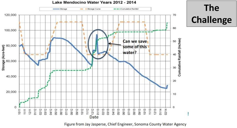
2 The Challenge
3 A Major Result from 10-years of Research Atmospheric rivers what they are, how they work, and their crucial role in both water supply and flooding across much of the U.S. West Coast Figure from an article in Scientific American by Dettinger and Ingram (January 2013)


4 35-45% of annual precipitation in California fell in association with Atmospheric Rivers, Floods and the Water Resources of California by Mike Dettinger, Marty Ralph,, Tapash Das, Paul Neiman, Dan Cayan Water, % of annual precipitation in the Pacific Northwest fell in association with atmospheric river events An average AR transports the equivalent of 7.5 times the average discharge of the Mississippi River, or ~10 M acre feet/day

 struck over about 3 weeks. Considers the 1861/82 floods as an example. Dettinger et al.")
5 ARkStorm: An emergency preparedness scenario for California USGS organized a large team of experts. A meteorology team was formed and built a plausible physical scenario. Back-to-back extreme AR events (mostly based on actual 1969 and 1986 storms) struck over about 3 weeks. Considers the 1861/82 floods as an example. Dettinger et al (Natural Hazards) Projected damage and economic losses exceed $500 Billion The meteorological scenario was then given to follow-on groups of experts in damage assessment and economic disruption estimation and has become the basis for emergency preparedness exercises.

6 Water year 2012 precipitation total was 46.2 inches Atmospheric Rivers Contribute to Annual Precipitation in Northern California s Key Region Providing much of the State s Water Supply One major AR event in Dec 2012 over 3-5 days provided about 1/3 of the entire Water Year s precipitation (i.e., 15 inches out of 46 inches)


7 California s Department of Water Resources (DWR) Program Applications of Atmospheric Rivers Network Data Flood Preparedness and Response Flood Planning Reservoir Coordinated Operations Water Supply Forecasting Courtesy of Mike Anderson - CA Dept. Water Resources - CA State climatologist

8 Atmospheric Rivers A UCSD/CW3E Vision Supporting California Water Management A Path Toward Solutions Concept Demonstrate that better monitoring and prediction of atmospheric river storms can enable increased water storage while maintaining flood control capabilities Strategies Develop, deploy and demonstrate new atmospheric-river-focused monitoring and prediction methods targeting extreme events and their roles in flooding and drought. This is done by advancing the science, observing systems, forecast models, decision support tools and communication methods. Expertise and Partnerships Needed: University, Local, State, Federal.

9 Atmospheric Rivers A UCSD/CW3E There is no Vision Silver Supporting bullet for California this complex Water problem. Management There is no silver bullet Requires an Integrated, Multi-disciplinary Strategy BENEFITS: Water Supply, Flood Control Decision Support Ecosystems, Tools + Forecast-Informed Hydropower, etc Reservoir Operations 21st Century Observations 21st Century Modeling Science F.M. Ralph Scripps/CW3E


10 Conceptual Observation Network and Forecast Lead Time for Atmospheric Rivers Recommendation from an interagency team presented in Ralph et al., 2014 Landfall Amplifying Jet Stream - RWD G-IV MJO 7-10 days UAVs Profilers Frontal wave stalls AR over CA - AROs Ensemble MJO Fcst Recurving West Pacific Tropicals 5-7 days Tropical Tap?

, NOAA and Scripps Inst.")
11 California has begun implementation of key land-based sensors An Atmospheric River-focused longterm observing network is being installed in CA as part of a 5-year project between CA Dept. of Water Resources (DWR), NOAA and Scripps Inst. Of Oceanography - Installed >100 field sites 11
, NOAA and Scripps Inst.")

 Russian River s highest flow in > 1 year Hawaii *CalWater-2 is a 5-year program (from 2015-2019)")
12 CalWater-2* Early Start field campaign 3-25 February 2014 Summary Courtesy of Marty Ralph UCSD/Scripps/Center for Western Weather and Water Extremes This AR increased precipitation-todate from 16% to 40% of normal in < 4 days in key Northern California watersheds, but runoff was muted due to dry soils. Up to > 12 inches of rain some drought relief Flight area for NOAA s G-IV aircraft on 8 Feb 2014 Goal: developing AR flight method to sample a frontal wave that can cause an AR to stall over one area at landfall (G-IV PI: Chris Fairall NOAA; Mission Scientists: Marty Ralph Scripps, Ryan Spackman STC) Russian River s highest flow in > 1 year Hawaii *CalWater-2 is a 5-year program (from ) proposed to focus on West Coast precipitation processes and how a changing climate will affect them. It is led by UCSD/Scripps with partners from DWR, CEC, NOAA, NASA, SSM/I satellite observations of water DOE vapor and on others. 8 Feb 2014 (Courtesy G. Wick, NOAA)
 Russian River s highest flow in > 1 year Hawaii *CalWater-2 is a 5-year program (from 2015-2019)")
 30N 30 N 20 N Remote aerosol plume (schematic) Hawaii 20N 40N 30N 160W 150W 140W 130W 18 December 2010")
13 50 N 40 N CalWater 2 / ACAPEX Observational Strategy Jan Mar N 40N 12 December 2010 Ship - DOE AMF2 - Small UAS - Air-sea fluxes - Precipitation estimates NOAA HMT Network Wind Profilers, Radars, GPS Met DOE G-1 - Aerosols - Microphysics Sierra Nevada and Coastal Ranges (white bars) 30N 30 N 20 N Remote aerosol plume (schematic) Hawaii 20N 40N 30N 160W 150W 140W 130W 18 December Dropsondes SSM/I satellite observations of IWV showing - Precipitation a strong atmospheric & Cloud Radar river on 12 Dec 2010 (from Ralph and Dettinger BAMS 2012) 20N 160W 150W 140W 130W 120W NOAA WP-3D - Aerosols & Trace Gas Instruments - Cloud Probes - Dropsondes - Precipitation & Cloud Radar NASA Global Hawk & NOAA G- IV 160 W 150 W 140 W 130 W IWV (g cm -2 ) Courtesy of F. M. Ralph, NOAA Earth System Research Laboratory
 5 6 7 Courtesy of F. M.")
14 Atmospheric River Experiment AREX Proposal to NASA s EV AO Marty Ralph (PI) Duane Waliser (Deputy PI), Ryan Spackman (Deputy PI) Scripps Institution of Oceanography NASA JPL Science and Technology Corporation NOAA Earth System Research Laboratory Water vapor budget of ARs offshore and their impacts on landfall - NASA Global Hawk (3 winters) - NASA DC-8 (2 winters) EFREP AR Obs network onshore
 - NASA DC-8 (2 winters) EFREP AR Obs network")

15 Droughts, on average, end with a bang (and begin with a whimper) all over the U.S. Atmospheric rivers provide the bang in a large fraction of the west coast drought breaks, especially in winters Dettinger, Michael D., 2013: Atmospheric Rivers as Drought Busters on the U.S. West Coast. J. Hydrometeor, 14,

16 Atmospheric Rivers (fall and winter) Great Plains Deep Convection (spring and summer) Spring Front Range Upslope (rain/snow) Scripps Institution of Oceanography Center for Western Weather and Water Extremes Southwest Monsoon (summer & fall) Where: UCSD/Scripps Inst. Oceanography La Jolla, California When: Start Who: Dr. F. M. Ralph (Director) Dr. Dan Cayan Dr. Mike Dettinger Dr. Ryan Spackman Mission Provide 21 st Century water cycle science, technology and outreach to support effective policies and practices that address the impacts of extreme weather and water events on the environment, people and the economy of Western North America Goal Revolutionize the physical understanding, observations, weather predictions and climate projections of extreme events in Western North America, including atmospheric rivers and the North American summer monsoon as well as their impacts on floods, droughts, hydropower, ecosystems and the economy

17 The Challenge Using modern science and engineering, and a collaborative approach to developing a small scale demonstration, the answer is likely YES A NEXT STEP IS UNDERWAY: A planning team has been formed to develop a detailed roadmap forward, including relevant local, state and federal entities, brought together by UCSD/Scripps/Center for Western Weather and Water Extremes. Information needs will be defined, potential solutions developed, to be carried out as a demonstration on Lake Mendocino in northern California.

18 Region for which atmospheric river events are a dominant cause of extreme precipitation, flooding and contribute to water supply in the Western U.S. (Ralph et al. 2014) Region of major atmospheric river influence Lake Mendocino - Pilot study Contact: F. Martin Ralph (mralph@ucsd.edu) Website:
 Region of major atmospheric river influence Lake Mendocino - Pilot study")
A Vision for Future Observations for Western U.S. Extreme Precipitation and Flooding
 A Vision for Future Observations for Western U.S. Extreme Precipitation and Flooding Dr. Marty Ralph Center for Western Weather and Water Extremes (CW3E) UCSD/Scripps Institution of Oceanography 24 June
[ Climate Data Collection and Forecasting Element ] An Advanced Monitoring Network In Support of the FloodER Program
![[ Climate Data Collection and Forecasting Element ] An Advanced Monitoring Network In Support of the FloodER Program](/thumbs/33/16326315.jpg "[ Climate Data Collection and Forecasting Element ] An Advanced Monitoring Network In Support of the FloodER Program") [ Climate Data Collection and Forecasting Element ] An Advanced Monitoring Network In Support of the FloodER Program December 2010 1 Introduction Extreme precipitation and the resulting flooding events
[ Climate Data Collection and Forecasting Element ] An Advanced Monitoring Network In Support of the FloodER Program December 2010 1 Introduction Extreme precipitation and the resulting flooding events
ARkStorm: California s Other Big One!
 ARkStorm: California s Other Big One! Understanding the Impacts of Massive Winter Storms Mark Jackson Meteorologist in Charge NOAA/National Weather Service Los Angeles/Oxnard What is ARkStorm? Emergency-preparedness
Climate, Drought, and Change Michael Anderson State Climatologist. Managing Drought Public Policy Institute of California January 12, 2015
 Climate, Drought, and Change Michael Anderson State Climatologist Managing Drought Public Policy Institute of California January 12, 2015 Oroville Reservoir January 2009 Presentation Overview The Rules
Climate Change. Lauma M. Jurkevics - DWR, Southern Region Senior Environmental Scientist
 Climate Change A n o t h e r F a c t o r i n M a n a g i n g S o u t h e r n C a l i f o r n i a s W a t e r R e s o u r c e s Lauma M. Jurkevics - DWR, Southern Region Senior Environmental Scientist USEPA-Region
HISTORICAL FLOODS: 1861 1862
 USGS Mission The USGS serves the Nation by providing reliable scientific information to describe and understand the Earth; minimize loss of life and property from natural disasters; manage water, biological,
Improved Warnings for Natural Hazards: A Prototype System for Southern California
 Improved Warnings for Natural Hazards: A Prototype System for Southern California Yehuda Bock Research Geodesist Scripps Institution of Oceanography University of California San Diego, La Jolla, Calif.
NASA, California Partner to Help Address Drought, Improve Water Management
 NASA, California Partner to Help Address Drought, Improve Water Management Jeanine Jones, California Department of Water Resources Lawrence Friedl, NASA Headquarters Thomas Painter, NASA Jet Propulsion
Great Plains and Midwest Climate Outlook 19 March 2015
 Great Plains and Midwest Climate Outlook 19 March 2015 Wendy Ryan Assistant State Climatologist Colorado State University wendy.ryan@colostate.edu Grass fire in SE Nebraska 13 March 2015 General Information
Water Year 2001 in Northern California: Have the Good Years Ended?
 Water Year 21 in Northern California: Have the Good Years Ended? Maurice Roos Abstract For the second water season in a row, precipitation and snowpack accumulation from October through December were far
21st Education Symposium AMS 92nd New Orleans, LA 24 January 2012 With thanks to: Image Acknowledgements: ç The Leviathan, from friedpost.
 The Return of the Mini-Course: Online and Field-Based Applied Meteorology for Majors Paul Ruscher Department of Earth, Ocean and Atmospheric Science Florida State University Tallahassee Image Acknowledgements:
FLOOD FORECASTING PRACTICE IN NORTHERN CALIFORNIA
 FLOOD FORECASTING PRACTICE IN NORTHERN CALIFORNIA California Department of Water Resources Post Office Box 219000, Sacramento, California 95821 9000 USA By Maurice Roos, Chief Hydrologist ABSTRACT Although
A 21 st century California observing network for monitoring extreme weather events
 1 2 3 4 5 6 A 21 st century California observing network for monitoring extreme weather events A. B. White 1, M. L. Anderson 2, M. D. Dettinger 3,4, F. M. Ralph 1, A. Hinojosa 2, D. R. Cayan 4,3, R. K.
Climate Change in North Carolina
 Climate Change in North Carolina Dr. Chip Konrad Director of the The Southeast Regional Climate Center Associate Professor Department of Geography University of North Carolina at Chapel Hill The Southeast
Section 5 CLIMATE TABLES
 Section Section CLIMATE SOURCES OF DATA... -1 HISTORICAL CONTEXT... -1 PRECIPITATION... -2 TEMPERATURES... -3 EVAPOTRANSPIRATION... -3 WIND SPEED AND DIRECTION... -4 DEGREE DAYS...-4 CONCLUSIONS AND RECOMMENDATIONS...
Integrating Near Real-Time Data for Coral Reef Ecosystem Forecasting
 Integrating Near Real-Time Data for Coral Reef Ecosystem Forecasting NOAA s Integrated Coral Observing Network (ICON) Atlantic Oceanographic and Meteorological Laboratory Laboratory Review, March 18, 2008
http://www.nrl.navy.mil/pao/pressrelease.php?y=2008&r=91-08r
 Page 1 of 7 NRL Press Release 91-08r 12/15/2008 nrlpao@nrl.navy.mil 202-767-2541 NRL's P-3 Aircraft Support Project to Study Tropical Cyclones Email Follow NRL RSS Feed Related Visuals The Naval Research
The National Integrated Drought Information System. The NIDIS Implementation Team www.drought.gov
 The National Integrated Drought Information System The NIDIS Implementation Team www.drought.gov National Integrated Drought Information System No systematic collection and analysis of social, environmental,
Extra-Tropical Cyclones in a Warming Climate:
 Extra-Tropical Cyclones in a Warming Climate: Observational Evidence of Trends in Frequencies and Intensities in the North Pacific, North Atlantic, & Great Lakes Regions David Levinson Scientific Services
SOUTHERN CALIFORNIA Regional Hydrology IMPACTS ON REGULATORY APPROACHES FOR THE FUTURE. Monitoring & Modeling
 SOUTHERN CALIFORNIA Regional Hydrology IMPACTS ON REGULATORY APPROACHES FOR THE FUTURE Monitoring & Modeling Summary This region provides a unique combination of policy issues, water quality problems,
THE STRATEGIC PLAN OF THE HYDROMETEOROLOGICAL PREDICTION CENTER
 THE STRATEGIC PLAN OF THE HYDROMETEOROLOGICAL PREDICTION CENTER FISCAL YEARS 2012 2016 INTRODUCTION Over the next ten years, the National Weather Service (NWS) of the National Oceanic and Atmospheric Administration
Climate Change Impacts on Water Resources in California. Resources for local managers. Jamie Anderson, Ph.D., P.E.
 Climate Change Impacts on Water Resources in California Resources for local managers Watersheds, Water Quality and a Changing Climate Moss Landing, CA October 21, 2009 Jamie Anderson, Ph.D., P.E. Department
Climate Extremes Research: Recent Findings and New Direc8ons
 Climate Extremes Research: Recent Findings and New Direc8ons Kenneth Kunkel NOAA Cooperative Institute for Climate and Satellites North Carolina State University and National Climatic Data Center h#p://assessment.globalchange.gov
Environmental Data Services for Delaware:
 Environmental Data Services for Delaware: Serving Emergency Responders, Planners, and Researchers Network Delaware Day November 6, 2013 Overview Operational Data Services More than just research DEOS and
CHUVA. by CHUVA Science Team. 4 th CHUVA Planning Meeting 13 December 2010 San Francisco, CA. Rachel I. Albrecht rachel.albrecht@cptec.inpe.
 CHUVA Cloud processes of the main precipitation systems in Brazil: A contribution to cloud resolving modeling and to the GPM (GlobAl Precipitation Measurement) by CHUVA Science Team Rachel I. Albrecht
The Coast of Crystal Cove Orange County, California
 The Coast of Crystal Cove Orange County, California by Hany Elwany, Ph.D. Scripps Institution of Oceanography Megan Hamilton, M.Sc. Coastal Environments Robert Robinson Dept. of Parks & Recreation Headwaters
Joint Polar Satellite System (JPSS)
") Joint Polar Satellite System (JPSS) John Furgerson, User Liaison Joint Polar Satellite System National Environmental Satellite, Data, and Information Service National Oceanic and Atmospheric Administration
Joint Polar Satellite System (JPSS) John Furgerson, User Liaison Joint Polar Satellite System National Environmental Satellite, Data, and Information Service National Oceanic and Atmospheric Administration
THE NATIONAL SPACE WEATHER PROGRAM
 1 Office of the Federal Coordinator for Meteorological Services and Supporting Research (OFCM) THE NATIONAL SPACE WEATHER PROGRAM Committee on Solar and Space Physics National Research Council Space Studies
SIXTH GRADE WEATHER 1 WEEK LESSON PLANS AND ACTIVITIES
 SIXTH GRADE WEATHER 1 WEEK LESSON PLANS AND ACTIVITIES WATER CYCLE OVERVIEW OF SIXTH GRADE WATER WEEK 1. PRE: Evaluating components of the water cycle. LAB: Experimenting with porosity and permeability.
Integrated Water Resources Science and Services. National Water Center
 TOO MUCH POOR QUALITY TOO LITTLE Integrated Water Resources Science and Services and the National Water Center Partnering to Address America s Water Resources Information Needs Mary G. Mullusky National
Anyone Else Notice That Its Been Windy Lately?
 National Weather Service Aberdeen, South Dakota January 2014 Inside this issue: Has it Been Windy Lately or What? 2013 Year in Review 2013 Year in Review (cont.) 1 2 3 Has it Been Windy Lately or What?
Satellite Weather And Climate (SWAC) Satellite and cloud interpretation
 Satellite and cloud interpretation") Satellite Weather And Climate (SWAC) Satellite and cloud interpretation Vermont State Climatologist s Office University of Vermont Dr. Lesley-Ann Dupigny-Giroux Vermont State Climatologist ldupigny@uvm.edu
Satellite Weather And Climate (SWAC) Satellite and cloud interpretation Vermont State Climatologist s Office University of Vermont Dr. Lesley-Ann Dupigny-Giroux Vermont State Climatologist ldupigny@uvm.edu
2013 Annual Climate Summary for the Southeast United States
 Months of heavy rain forced the U.S. Army Corp of Engineers to open the spillways at Lake Hartwell, located at the headwaters of the Savannah River along the South Carolina-Georgia border, on July 9,.
The IPCC Special Report on Managing the Risks of Extreme Events and Disasters to Advance Climate Change Adaptation
 The IPCC Special Report on Managing the Risks of Extreme Events and Disasters to Advance Climate Change Adaptation A changing climate leads to changes in extreme weather and climate events 2 How do changes
2. The map below shows high-pressure and low-pressure weather systems in the United States.
 1. Which weather instrument has most improved the accuracy of weather forecasts over the past 40 years? 1) thermometer 3) weather satellite 2) sling psychrometer 4) weather balloon 6. Wind velocity is
Ensuring the Preparedness of Users: NOAA Satellites GOES R, JPSS Laura K. Furgione
 Ensuring the Preparedness of Users: NOAA Satellites GOES R, JPSS Laura K. Furgione U.S. Permanent Representative with the WMO Deputy Director, NOAA s s National Weather Service WMO Executive Council 65
Development of an Integrated Data Product for Hawaii Climate
 Development of an Integrated Data Product for Hawaii Climate Jan Hafner, Shang-Ping Xie (PI)(IPRC/SOEST U. of Hawaii) Yi-Leng Chen (Co-I) (Meteorology Dept. Univ. of Hawaii) contribution Georgette Holmes
National Data Buoy Center Cooperative Relations
 National Data Buoy Center Cooperative Relations Presentation For NGI Annual Conference May 23, 2012 Landry Bernard National Data Buoy Center Operational Mission To provide a real-time, end-to-end capability
How to analyze synoptic-scale weather patterns Table of Contents
 How to analyze synoptic-scale weather patterns Table of Contents Before You Begin... 2 1. Identify H and L pressure systems... 3 2. Locate fronts and determine frontal activity... 5 3. Determine surface
Florida Institute of Oceanography
 Florida Institute of Oceanography Dr. William T. Hogarth, Interim Director, FIO & Dr. Jyotika I. Virmani, Associate Director, FIO National Water Quality Monitoring Council New Orleans, LA May 3-5, 2011
LAURA M. EDWARDS. EDUCATION M.S. Meteorology University of Maryland 2003 B.A. Physics and French University of Minnesota 1999
 LAURA M. EDWARDS SDSU Extension and Division of Atmospheric Sciences Desert Research Institute 13 2 nd Ave SE Aberdeen, SD 57401 (605) 626-2870 laura.edwards@sdstate.edu EDUCATION M.S. Meteorology University
Climate of Illinois Narrative Jim Angel, state climatologist. Introduction. Climatic controls
 Climate of Illinois Narrative Jim Angel, state climatologist Introduction Illinois lies midway between the Continental Divide and the Atlantic Ocean, and the state's southern tip is 500 miles north of
S.No Scientific positions No Of Posts Pay Band Grade Pay 10 `. 15600-39100 ` 7600 04 `. 15600-39100 ` 7600 03 `. 15600-39100 ` 7600
 EARTH SYSTEM SCIENCE ORGANIZATION (ESSO) Ministry of Earth Sciences, Government of India INDIAN INSTITUTE OF TROPICAL METEOROLOGY, PUNE-411008 Advertisement No. PER/4/2014 The Indian Institute of Tropical
CE394K GIS IN WATER RESOURCES TERM PROJECT REPORT
 CE394K GIS IN WATER RESOURCES TERM PROJECT REPORT Soil Water Balance in Southern California Cheng-Wei Yu Environmental and Water Resources Engineering Program Introduction Historical Drought Condition
2. G-IV Tail Doppler Radar Experiment
 2. G-IV Tail Doppler Radar Experiment Principal Investigator(s): John Gamache, Peter Dodge, Paul Reasor, Altug Aksoy, and Vijay Tallapragada Primary IFEX Goal: 1 - Collect observations that span the TC
Overview of NASA Applied Remote Sensing Training Program on Water Resources and Disaster Management
 Overview of NASA Applied Remote Sensing Training Program on Water Resources and Disaster Management ARSET Applied Remote SEnsing Training A project of NASA Applied Sciences Outline About ARSET ARSET Trainings
NASA Earth System Science: Structure and data centers
 SUPPLEMENT MATERIALS NASA Earth System Science: Structure and data centers NASA http://nasa.gov/ NASA Mission Directorates Aeronautics Research Exploration Systems Science http://nasascience.nasa.gov/
7.10 INCORPORATING HYDROCLIMATIC VARIABILITY IN RESERVOIR MANAGEMENT AT FOLSOM LAKE, CALIFORNIA
 7.10 INCORPORATING HYDROCLIMATIC VARIABILITY IN RESERVOIR MANAGEMENT AT FOLSOM LAKE, CALIFORNIA Theresa M. Carpenter 1, Konstantine P. Georgakakos 1,2, Nicholas E. Graham 1,2, Aris P. Georgakakos 3,4,
Real-time Ocean Forecasting Needs at NCEP National Weather Service
 Real-time Ocean Forecasting Needs at NCEP National Weather Service D.B. Rao NCEP Environmental Modeling Center December, 2005 HYCOM Annual Meeting, Miami, FL COMMERCE ENVIRONMENT STATE/LOCAL PLANNING HEALTH
City of Salinas Flood Response Preparations
 City of Salinas Flood Response Preparations Winter Preparations Goals for 2015/2016 Community Preparedness in the event of flooding Media cooperation on safety and preparedness, public information sharing
NCDC Strategic Vision
 NOAA s National Climatic Data Center World s Largest Archive of Climate and Weather Data Presented to: Coastal Environmental Disasters Data Management Workshop September 16, 2014 Stephen Del Greco Deputy
EPA Trends for wastewater Treatment in California - 2011
 EPA S TECHNOLOGY NEEDS FOR THE WATER AND WASTEWATER INDUSTRY Nancy Stoner Acting Assistant Administrator U.S. EPA Office of Water International Emerging Technology Symposium Arlington, VA April 23rd, 2014
Thoughts on Mobile Instrument Facilities/ Logistics of Remote Data Collection
 Thoughts on Mobile Instrument Facilities/ Logistics of Remote Data Collection Douglas Sisterson ARM Climate Research Facility Operations Manager DOE Permafrost Workshop February 14-15, 2011 ARM Facilities
Active and Passive Microwave Remote Sensing
 Active and Passive Microwave Remote Sensing Passive remote sensing system record EMR that was reflected (e.g., blue, green, red, and near IR) or emitted (e.g., thermal IR) from the surface of the Earth.
User s Guide. Zuniga Point. Point Loma
 User s Guide Welcome to the Location File for San Diego Bay, located in the southwestern corner of the U.S. San Diego Bay has an excellent natural harbor, which has made it a busy commercial port. San
The State of the Climate And Extreme Weather. Deke Arndt NOAA s National Climatic Data Center
 The State of the Climate And Extreme Weather Deke Arndt June Feb 2013 2011 1 The world s largest archive of weather and climate data NCDC is located in Asheville, North Carolina A place of active retirement
Climate Trends In New England and Its Impact on Storm Behavior; Riverine and Coastal Flood Impacts
 2 ND ANNUAL CAPE COASTAL CONFERENCE JUNE 6 Linking Science with Local Solutions and Decision-Making Climate Trends In New England and Its Impact on Storm Behavior; Riverine and Coastal Flood Impacts David
Landsat Monitoring our Earth s Condition for over 40 years
 Landsat Monitoring our Earth s Condition for over 40 years Thomas Cecere Land Remote Sensing Program USGS ISPRS:Earth Observing Data and Tools for Health Studies Arlington, VA August 28, 2013 U.S. Department
Climate Change Long Term Trends and their Implications for Emergency Management August 2011
 Climate Change Long Term Trends and their Implications for Emergency Management August 2011 Overview A significant amount of existing research indicates that the world s climate is changing. Emergency
5. PROFESSIONAL SERVICES
 Joseph B. Zambon Department of Marine, Earth and Atmospheric Sciences, North Carolina State University Jordan Hall Rm. 4133, Raleigh, North Carolina 27695-8208 Tel: 716.435.9707; Email: jbzambon@ncsu.edu;
Assiniboine River and Lake Manitoba Basins Flood Mitigation Study: Providing Greater Protection For Manitobans From Flood Risks
 Assiniboine River and Lake Manitoba Basins Flood Mitigation Study: Providing Greater Protection For Manitobans From Flood Risks Welcome! Manitoba Infrastructure and Transportation is studying flooding
The NIDIS Pilot in the Upper Colorado River Basin
 The NIDIS Pilot in the Upper Colorado River Basin Jim Verdin (USGS), Roger Pulwarty (NOAA), Nolan Doesken (CSU), Mike Gillespie (NRCS), Kevin Werner (NOAA), Olga Wilhelmi (NCAR), Michael Lewis (USGS),
Heavy Rainfall from Hurricane Connie August 1955 By Michael Kozar and Richard Grumm National Weather Service, State College, PA 16803
 Heavy Rainfall from Hurricane Connie August 1955 By Michael Kozar and Richard Grumm National Weather Service, State College, PA 16803 1. Introduction Hurricane Connie became the first hurricane of the
In This Issue. El Niño and Florida s Expected Severe Weather by Daniel Noah, Warning Coordination Meteorologist
 Wiinter 2015//2016 In This Issue El Niño and Florida s Expected Severe Weather National Weather Service Tampa Bay s Newest Forecaster New Marine Advisory Group forms at NWS Tampa We Are Looking for Ambassadors
Climate Change on the Prairie:
 Climate Change on the Prairie: A Basic Guide to Climate Change in the High Plains Region - UPDATE Global Climate Change Why does the climate change? The Earth s climate has changed throughout history and
WEATHER AND CLIMATE practice test
 WEATHER AND CLIMATE practice test Multiple Choice Identify the choice that best completes the statement or answers the question. 1. What role does runoff play in the water cycle? a. It is the process in
A Microwave Retrieval Algorithm of Above-Cloud Electric Fields
 A Microwave Retrieval Algorithm of Above-Cloud Electric Fields Michael J. Peterson The University of Utah Chuntao Liu Texas A & M University Corpus Christi Douglas Mach Global Hydrology and Climate Center
CLIMATE, WATER & LIVING PATTERNS THINGS
 CLIMATE, WATER & LIVING PATTERNS NAME THE SIX MAJOR CLIMATE REGIONS DESCRIBE EACH CLIMATE REGION TELL THE FIVE FACTORS THAT AFFECT CLIMATE EXPLAIN HOW THOSE FACTORS AFFECT CLIMATE DESCRIBE HOW CLIMATES
CSC SEEKS TO MONETIZE CLIMATE DATA WITH BIG DATA ANALYTICS SEPTEMBER 2012
 CSC SEEKS TO MONETIZE CLIMATE DATA WITH BIG DATA ANALYTICS SEPTEMBER 2012 Verdantix Ltd 2007-2012. Reproduction Prohibited. CSC SEEKS TO MONETIZE CLIMATE DATA WITH BIG DATA ANALYTICS September 2012 EXECUTIVE
Homepage: http://www.opetus.physics.helsinki.fi/oppiaineet/meteorologia.html
 METEOROLOGY Homepage: http://www.opetus.physics.helsinki.fi/oppiaineet/meteorologia.html DEGREE REQUIREMENTS Students who have begun their studies 1.8.2014 or later study according to these degree requirements.
Titelmasterformat durch Klicken. bearbeiten
 Evaluation of a Fully Coupled Atmospheric Hydrological Modeling System for the Sissili Watershed in the West African Sudanian Savannah Titelmasterformat durch Klicken June, 11, 2014 1 st European Fully
National Data Buoy Center Command Briefing For
 National Data Buoy Center Command Briefing For Marine Technology Society Oceans in Action August 21, 2014 Helmut H. Portmann, Director National Data Buoy Center To provide a real-time, end-to-end capability
Climate Change in Mexico implications for the insurance and reinsurance market
 Climate Change in Mexico implications for the insurance and reinsurance market Eberhard Faust Geo Risks Research Munich Reinsurance Company 1980 April 2008: Billion & Ten Billion Dollar Losses The costliest
WEATHER AND CLIMATE WHY DOES IT MATTER?
 WEATHER AND CLIMATE Rising global average temperature is associated with widespread changes in weather patterns. Scientific studies indicate that extreme weather events such as heat waves and large storms
Geographic Factors for Data Center Site Selection
 Geographic Factors for Data Center Site Selection A White Paper March 2008 Companies rely on their data center to provide the foundation for much of their business. Because of that, a thorough evaluation
TOPIC: CLOUD CLASSIFICATION
 INDIAN INSTITUTE OF TECHNOLOGY, DELHI DEPARTMENT OF ATMOSPHERIC SCIENCE ASL720: Satellite Meteorology and Remote Sensing TERM PAPER TOPIC: CLOUD CLASSIFICATION Group Members: Anil Kumar (2010ME10649) Mayank
Severe Weather & Hazards Related Research at CREST
 Severe Weather & Hazards Related Research at CREST (Lead Scientists) Z. Johnny Luo, Nir Krakauer, Shayesteh Mahani, Fabrice Papa, Marouane Temimi and Brian Vant Hull (NOAA Collaborators) Arnold Gruber,
II. Related Activities
 (1) Global Cloud Resolving Model Simulations toward Numerical Weather Forecasting in the Tropics (FY2005-2010) (2) Scale Interaction and Large-Scale Variation of the Ocean Circulation (FY2006-2011) (3)
Chapter Overview. Seasons. Earth s Seasons. Distribution of Solar Energy. Solar Energy on Earth. CHAPTER 6 Air-Sea Interaction
 Chapter Overview CHAPTER 6 Air-Sea Interaction The atmosphere and the ocean are one independent system. Earth has seasons because of the tilt on its axis. There are three major wind belts in each hemisphere.
Technical Attachment. Developing a Local Outreach Program. Mark A. Rose NWS Nashville, Tennessee. Timothy W. Troutman NWS Huntsville, Alabama
 SR SSD 2003-15 9/2003 Technical Attachment Developing a Local Outreach Program Mark A. Rose NWS Nashville, Tennessee Timothy W. Troutman NWS Huntsville, Alabama Introduction In late 2000, a team at WFO
Jessica Blunden, Ph.D., Scientist, ERT Inc., Climate Monitoring Branch, NOAA s National Climatic Data Center
 Kathryn Sullivan, Ph.D, Acting Under Secretary of Commerce for Oceans and Atmosphere and NOAA Administrator Thomas R. Karl, L.H.D., Director,, and Chair of the Subcommittee on Global Change Research Jessica
http://www.isac.cnr.it/~ipwg/
 The CGMS International Precipitation Working Group: Experience and Perspectives Vincenzo Levizzani CNR-ISAC, Bologna, Italy and Arnold Gruber NOAA/NESDIS & Univ. Maryland, College Park, MD, USA http://www.isac.cnr.it/~ipwg/
Deke Arndt Climate Monitoring Branch Na6onal Clima6c Data Center 25 June 2013
 Deke Arndt Climate Monitoring Branch Na6onal Clima6c Data Center 25 June 2013 The National Climatic Data Center The World s Largest Archive of Weather & Climate Data NCDC is located in Asheville, North
Submission by the United States of America to the UN Framework Convention on Climate Change Communication of U.S. Adaptation Priorities May 29, 2015
 Submission by the United States of America to the UN Framework Convention on Climate Change Communication of U.S. Adaptation Priorities May 29, 2015 Adaptation is a challenge for all Parties. In addition
Hazard Detection, Monitoring, Modeling, Assessment and Warning in the Asia Pacific Region
 Chengdu Forum on UN-GGIM Global Map for Sustainable Development: Development and Applications in Urban Hazard Mapping Chengdu, Sichuan Province, China 15-17 Oct 2013 Hazard Detection, Monitoring, Modeling,
SITE SPECIFIC WEATHER ANALYSIS REPORT
 SAMPLE FLOOD ANALYSIS REPORT SITE SPECIFIC WEATHER ANALYSIS REPORT PREPARED FOR: Law Offices of Oliver Wendell Douglas Oliver Wendell Douglas PREPARED BY: November 29, 2007 CASE REFERENCE: Arnold Ziffel
CEOS Water Portal Status Update
 CEOS Water Portal Status Update WGISS-33 Tokyo, Japan April 23-27, 2012 JAXA/Mission Operations System Office Satoko Miura/ Atsushi Kawai Update since WGISS-32 New features Compare service for MOLTS data
Addressing Declining Elevations in Lake Mead
 Integrated Resource Planning Advisory Committee July 23, 2014 Addressing Declining Elevations in Lake Mead 1 Meeting Topics Drought update Attribute finalization Interbasin Cooperation Intake Pumping Station
Adaptation to a Changing Climate
 Adaptation to a Changing Climate City Infrastructure Preparedness David MacLeod City of Toronto Environment Office March 3, 2011 WHAT IS CITY INFRASTRUCTURE? Physical (Hard) Infrastructure Buildings Municipal
Precipitation Monitoring Network:
 The Caribbean Drought and Precipitation Monitoring Network: Adrian R. Trotman Caribbean Institute for Meteorology and Hydrology CARIWIN Regional Seminar 14-15 January, 2010 Georgetown, Guyana Why Plan
Town of Warwick, Village of Florida, Village of Greenwood Lake and Village of Warwick MULTI JURISIDICTIONAL, MULTI HAZARD MITIGATION PLAN DRAFT
 Town of Warwick, Village of Florida, Village of Greenwood Lake and Village of Warwick MULTI JURISIDICTIONAL, MULTI HAZARD MITIGATION PLAN DRAFT Appendix B Historical Hazard Documentation Rev #0 May 2013
Geospatial Software Solutions for the Environment and Natural Resources
 Geospatial Software Solutions for the Environment and Natural Resources Manage and Preserve the Environment and its Natural Resources Our environment and the natural resources it provides play a growing
A remote sensing instrument collects information about an object or phenomenon within the
 Satellite Remote Sensing GE 4150- Natural Hazards Some slides taken from Ann Maclean: Introduction to Digital Image Processing Remote Sensing the art, science, and technology of obtaining reliable information
How To Forecast Solar Power
 Forecasting Solar Power with Adaptive Models A Pilot Study Dr. James W. Hall 1. Introduction Expanding the use of renewable energy sources, primarily wind and solar, has become a US national priority.
Global Flood Partnership
 Global Flood Partnership Global tools and services for managing flood risk and emergencies Dr. Tom De Groeve Joint Research Centre of the European Commission tom.de-groeve@jrc.ec.europe.eu State of global
FORECAST-COORDINATED OPERATIONS FOR THE YUBA-FEATHER RIVER RESERVOIR SYSTEM: INTERAGENCY COOPERATION
 FORECAST-COORDINATED OPERATIONS FOR THE YUBA-FEATHER RIVER RESERVOIR SYSTEM: INTERAGENCY COOPERATION Author(s): Rob Hartman, Hydrologist-in-Charge, California Nevada River Forecast Center, National Weather
Climate, water and renewable energy in the Nordic countries
 102 Regional Hydrological Impacts of Climatic Change Hydroclimatic Variability (Proceedings of symposium S6 held during the Seventh IAHS Scientific Assembly at Foz do Iguaçu, Brazil, April 2005). IAHS
National Aeronautics and Space Administration NASA & GREEN ROOF RESEARCH. Utilizing New Technologies to Update an Old Concept. www.nasa.
 National Aeronautics and Space Administration NASA & GREEN ROOF RESEARCH Utilizing New Technologies to Update an Old Concept www.nasa.gov NASA Utilizes New Technologies to Update an Old Concept NASA s
MAGIC: Marine ARM GPCI Investigations of Clouds
 MAGIC: Marine ARM GPCI Investigations of Clouds Principal Investigators Ernie R. Lewis (Brookhaven National Laboratory) elewis@bnl.gov Warren J. Wiscombe (NASA Goddard Space Flight Center) Co-Investigators
National Dam Safety Program Technical Seminar #22. When is Flood Inundation Mapping Not Applicable for Forecasting
 National Dam Safety Program Technical Seminar #22 Thursday February 19 th 2015 Emmittsburg, MD When is Flood Inundation Mapping Not Applicable for Forecasting Victor Hom Hydrologic Services Division National