10th Czech-Polish Workshop. Andrzej Araszkiewicz, Janusz Bogusz, Mariusz Figurski
|
|
|
- Lilian Osborne
- 8 years ago
- Views:
Transcription
1 10th Czech-Polish Workshop ON RECENT GEODYNAMICS OF THE SUDETEN AND ADJACENT AREAS Application of short-time time GNSS solutions to geodynamical studies preliminary results Andrzej Araszkiewicz, Janusz Bogusz, Mariusz Figurski

2 Motivation
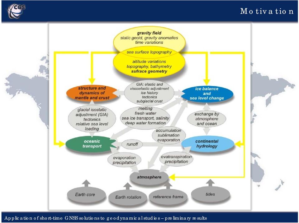
3 Motivation

4 Strategy Reference (datum) - few EPN stations (BOR1, WTZR, METS, POTS, ONSA); Only GPS observations (RINEX format) were used with carrier phase as a basic observable bl (double-differences, diff ionosphere-free linear combination); Processing strategy and models - similar to EPN Planetary ephemeris - DE405 Ocean tides - OT_CSRC MODELS Earth geopotential model - JGM3 Nutation model - IERS2000 Tidal displacements: Solid tides-according to IERS 1996/2000 standards Ocean loading model FES2004

5 Strategy Software Bernese 5.0 Elevation angle cutoff - 3 degrees, elevation dependent weighting using cos(z); Orbits and ERPs: IGS precise final orbits and ERPs; Troposphere: Saastamoinen- based dry component (Dry-Niell mapping function) as a priori i model and the Wet-Niell mapping function; Ionosphere - CODE global iono models (help to increase the number of resolved ambiguities),finally cancelled out due to ionosphere-free linear combination; Ambiguity - QIF strategy - for baseline lengths shorter than 100 km - L5/L3 approach, for baselines shorter than 20 km - L1/L2 approach.
,finally cancelled out due to ionosphere-free linear combination; Ambiguity - QIF")
6 Strategy

7 Data ASG-EUPOS (Polish Active Geodetic Network) - the Multifunctional precise satellite positioning system ASG-EUPOS established by the Head Office of Geodesy and Cartography. Consists of: 84 Polish sites with GPS module; 14 Polish sites with GPS/GLONASS module; 20 foreign sites. Data from January 2009 to March 2009.

8 Data 1 CBRU Bruntal Czech Republic 2 CFRM Frýdek Místek Czech Republic 3 CLIB Liberec Czech Republic 4 CPAR Pardubice Czech Republic 5 CSUM Šumperk Czech Republic 6 CSVI Svitavy Czech Republic 7 CTRU Trutnov Czech Republic 8 GANP PopradGanovce Slovakia 9 JLGR Jelenia Góra Poland 10 KATO Katowice Poland 11 KLDZ Kłodzko Poland 12 KRAW Kraków Poland 13 KROS Krosno Poland 14 KUZA Žilina Slovakia 15 LEGN Legnica Poland 16 LIE1 Liesek Slovakia 17 MILO Miłocin Poland 18 NWSC Nowy Sącz Poland 19 NWTG Nowy Targ Poland 20 NYSA Nysa Poland 21 OPLE Opole Poland 22 PROS Proszowice Poland 23 PRZM Przemyśl Poland 24 SKSK Svidnik Slovakia 25 SKSL Stará L'ubovňa Slovakia 26 SKSV Snina Slovakia 27 TARG Tarnowskie Góry Poland 28 TRNW Tarnów Poland 29 USDL Ustrzyki Dolne Poland 30 WLBR Wałbrzych Poland 31 WODZ Wodzisław Śląski Poland 32 WROC Wrocław Poland 33 ZYWI Żywiec Poland

9 Data Jelenia Góra

10 Data Wałbrzych
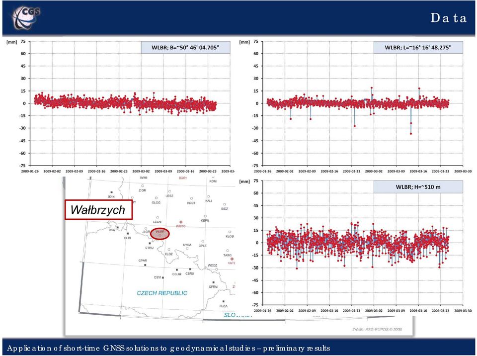
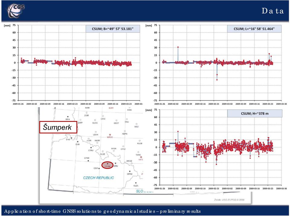
11 Data Šumperk
12 Data Bruntal

13 Data Stará L'ubovňa

14 Data Svidnik

15 B [mm] L [mm] Poprad Ganovce H [mm] daily solutions; hourly solutions.
![[mm] daily](/docs-images/43/3093599/images/page_15.jpg "solutions; hourly")
16 B [mm] L [mm] Nysa H [mm] daily solutions; hourly solutions.

17 B [mm] L [mm] Šumperk H [mm] daily solutions; hourly solutions.

18 sites with no oscillations; sites with strong long-period changes; sites with no dominant oscillation; sites with dominant diurnal oscillation; sites with dominant sub-diurnal oscillations: 12-hours, 8-hours, 6-hours, noisy sites; sites with strange frequency behaviour.

19 B [mm] L [mm] Kłodzko 12-hour oscillations H [mm]

20 B [mm] L [mm] Liesek long-period changes H [mm]

21 B [mm] L [mm] Snina long-period changes H [mm]
22 B [mm] L [mm] Svidnik long-period changes H [mm]
23 B [mm] L [mm] Žilina noisy H [mm]
24 B [mm] L [mm] Jelenia Góra no oscillations H [mm]
25 B [mm] Nowy Targ diurnal oscillation
26 B [mm] Legnica diurnal oscillation
27 L [mm] Nowy Sącz diurnal oscillation
28 L [mm] Katowice diurnal oscillation
29 Przemyśl diurnal oscillation H [mm]
30 Liberec diurnal oscillation H [mm]
31 Opole diurnal oscillation H [mm]
32 Stará L'ubovňa diurnal oscillation H [mm]
33 B [mm] Tarnów 12-hour oscillations
34 B [mm] Trutnov 12-hour oscillations
35 L [mm] Ustrzyki Dolne 12-hour oscillations
36 L [mm] Żywiec 12-hour oscillations
37 Kłodzko 12-hour oscillations H [mm]
38 Kraków 12-hour oscillations H [mm]
39 B [mm] Žilina 8-hour oscillations
40 L [mm] Krosno 8-hour oscillations
41 Proszowice 8-hour oscillations H [mm]
42 B [mm] Wałbrzych 6-hour oscillations
43 B [mm] Nowy Sącz 6-hour oscillations
44 L [mm] Stará L'ubovňa 6-hour oscillations
45 L [mm] Wodzisław 6-hour oscillations
46 Tarnów 6-hour oscillations H [mm]
47 Wodzisław 6-hour oscillations H [mm]
48 B [mm] Przemyśl no dominant oscillations
49 L [mm] Milowice no dominant oscillations
50 Krosno no dominant oscillations H [mm]
51 B [mm] Tarnowskie Góry strange frequency behaviour
52 L [mm] Žilina strange frequency behaviour
53 Summary Relatively high consistency of the analysed time series: Even 4-hour oscillations are clearly seen; Site σ B [mm] σ L [mm] σ H [mm] CBRU 2,4 4,5 5,6 CLIB 4,5 6,9 9,1 CSUM 2,4 3,5 7,3 WLBR 3,9 5,1 8,4 SKSK 5,1 7,2 12,8 SKSL 4,7 4,5 10,2 JLGR 2,8 3,3 6,9 Too many outliers in L coordinate better ionospheric (scintillations, fluctuations of TEC, moving ionosphere perturbations TID) and tropospheric (4D model of water vapour distribution) models should be implemented; For proper interpretation distinguish between pure dynamic effects and others (e.g. thermal effects) is necessary; Verification of the existing models will be possible.
54 Thank you for your attention. ti
Günter Seeber. Satellite Geodesy 2nd completely revised and extended edition
 Günter Seeber Satellite Geodesy 2nd completely revised and extended edition Walter de Gruyter Berlin New York 2003 Contents Preface Abbreviations vii xvii 1 Introduction 1 1.1 Subject of Satellite Geodesy...
Recent Activities of the SGO Local Analysis Centre
 Recent Activities of the SGO Local Analysis Centre Tamás Jambor jambor@sgo.fomi.hu, Ambrus Kenyeres kenyeres@sgo.fomi.hu Satellite Geodetic Observatory, Institute of Geodesy, Cartography and Remote Sensing
Towards Real-time GNSS Troposphere Delay Monitoring Service for Poland
 Towards Real-time GNSS Troposphere Delay Monitoring Service for Poland Tomasz Hadas, Kaplon Jan, Bosy Jaroslaw Institute of Geodesy and Geoinformatics Wroclaw University of Environmental and Life Sciences
Local monitoring by low cost devices and free and open sources softwares
 Local monitoring by low cost devices and free and open sources softwares Abstract Ludovico Biagi, Florin-Catalin Grec, Marco Negretti, Maria Grazia Visconti Politecnico di Milano, DICA@ComoCampus The purpose
Processing of ground based GNSS data to produce near real time (NRT) tropospheric zenith
 tropospheric zenith") Processing of ground based GNSS data to produce near real time (NRT) tropospheric zenith path delays (ZTD) Jan Douša (jan.dousa@pecny.cz) Geodetic Observatory Pecný, Research Institute of Geodesy, Topography
Processing of ground based GNSS data to produce near real time (NRT) tropospheric zenith path delays (ZTD) Jan Douša (jan.dousa@pecny.cz) Geodetic Observatory Pecný, Research Institute of Geodesy, Topography
Pilot Processing Center in Argentina. Facultad de Ciencias Astronómicas y Geofísicas Universidad Nacional de La Plata
 Pilot Processing Center in Argentina María Paula Natali, Mariano MüllerM Facultad de Ciencias Astronómicas y Geofísicas Universidad Nacional de La Plata Processing Centers CPLat Centro de procesamiento
MONITORING OF STATION VYHL
 LONG-TERM POSITIONAL MONITORING OF STATION VYHL OF THE SNĚŽ ĚŽNÍK NETWORK Josef Weigel, Otakar Švábenský Brno University of Technology Department of Geodesy weigel.j@ fce.vutbr.cz svabensky.o@fce.vutbr.cz
The IGS: A Multi-GNSS Service
 The IGS: A Multi-GNSS Service Chris Rizos, Urs Hugentobler, Ruth Neilan IUGG IAG Structure International Union of Geodesy and Geophysics (IUGG) 65 Member Countries (Adhering Bodies), 8 Associations International
GPS Precise Point Positioning as a Method to Evaluate Global TanDEM-X Digital Elevation Model
 GPS Precise Point Positioning as a Method to Evaluate Global TanDEM-X Digital Elevation Model 7 th FIG Regional Conference TS 1C Advances in GNSS Positioning and Applications I Volker Schwieger 1, Jürgen
GNSS re-processing results at GOP and the latest updates of ITRS/ETRS. Jan Douša (jan.dousa@pecny.cz)
") GNSS re-processing results at GOP and the latest updates of ITRS/ETRS Jan Douša (jan.dousa@pecny.cz) Geodetic observatory Pecný, Research Institute of Geodesy, Topography and Cartography January 24, 2012
GNSS re-processing results at GOP and the latest updates of ITRS/ETRS Jan Douša (jan.dousa@pecny.cz) Geodetic observatory Pecný, Research Institute of Geodesy, Topography and Cartography January 24, 2012
Trimble CenterPoint RTX Post-Processing Services FAQs
 Trimble CenterPoint RTX Post-Processing Services FAQs What is Trimble RTX technology? 30 September 2013 Trimble RTX TM (Real Time extended) is a high-accuracy, global GNSS correction technology that combines
IGS Preparations for the Next Reprocessing and ITRF
 IGS Preparations for the Next Reprocessing and ITRF what is IG2? who will contribute? expected performance remaining issues Jake Griffiths, NOAA/National Geodetic Survey Paul Rebischung, Institut Géographique
TESTING REAL-TIME GPS ORBIT AND CLOCK PRODUCT
 TESTING REAL-TIME GPS ORBIT AND CLOCK PRODUCT J. DOUSA1 1. Introduction Within EUREF-IP project, the Federal Agency for Cartography and Geodesy, Frankfurt/Main (BKG) has started to distribute the real-time
The Use and Integrity Monitoring of IGS Products at Geoscience Australia (GA)
") Australian Government Geoscience Australia The Use and Integrity Monitoring of IGS Products at Geoscience Australia (GA) Ramesh Govind, John Dawson, John Manning IGS-2004 Workshop and Symposium Berne,
Australian Government Geoscience Australia The Use and Integrity Monitoring of IGS Products at Geoscience Australia (GA) Ramesh Govind, John Dawson, John Manning IGS-2004 Workshop and Symposium Berne,
The Applanix SmartBase TM Software for Improved Robustness, Accuracy, and Productivity of Mobile Mapping and Positioning
 The Applanix SmartBase TM Software for Improved Robustness, Accuracy, and Productivity of Mobile Mapping and Positioning Joe Hutton and Edith Roy, Applanix Corporation Introduction Applanix, along with
AUTOMATED OPERATIONAL MULTI-TRACKING HIGH PRECISION ORBIT DETERMINATION FOR LEO MISSIONS
 AUTOMATED OPERATIONAL MULTI-TRACKING HIGH PRECISION ORBIT DETERMINATION FOR LEO MISSIONS J. Fernández Sánchez, F. M. Martínez Fadrique, A. Águeda Maté, D. Escobar Antón GMV S.A., Isaac Newton 11, 876 Tres
GNSS and Heighting, Practical Considerations. A Parker National Geo-spatial Information Department of Rural Development and Land Reform
 GNSS and Heighting, Practical Considerations A Parker National Geo-spatial Information Department of Rural Development and Land Reform GNSS Global Navigation Satellite Systems (GNSS) Global Positioning
GOP LOCAL Analysis Centre Centre Report (2010-2013)
") GOP LOCAL Analysis Centre Centre Report (2010-2013) 1 J. Douša, P. Václavovic (jan.dousa@pecny.cz) Geodetic Observatory Pecný Research Institute of Geodesy, Topography and Czech Republic EUREF LAC Workshop
GOP LOCAL Analysis Centre Centre Report (2010-2013) 1 J. Douša, P. Václavovic (jan.dousa@pecny.cz) Geodetic Observatory Pecný Research Institute of Geodesy, Topography and Czech Republic EUREF LAC Workshop
Non-parametric estimation of seasonal variations in GNSS-derived time series
 Military University of Technology, Poland (marta.gruszczynska@wat.edu.pl) Seasonal variations in the frame sites can bias the frame realization. I would like to invite you to click on each of the four
Satellite Posi+oning. Lecture 5: Satellite Orbits. Jan Johansson jan.johansson@chalmers.se Chalmers University of Technology, 2013
 Lecture 5: Satellite Orbits Jan Johansson jan.johansson@chalmers.se Chalmers University of Technology, 2013 Geometry Satellite Plasma Posi+oning physics Antenna theory Geophysics Time and Frequency GNSS
GNSS permanent stations as the part of integrated geodetic system in Estonia
 GNSS permanent stations as the part of integrated geodetic system in Estonia Karin Kollo (MSc) Department of Geodesy Estonian Land Board United Nations/Croatia Workshop on the applications of Global Navigation
Study on development potentials for long-distance passenger rail transport along TEN-T Corridor III
 Study on development potentials for long-distance passenger rail transport along TEN-T Corridor III Responsible body: Biuro Rozwoju Wrocławia ul. Świdnicka 53 PL 50-030 Wrocław Elaboration: ETC Transport
European Geodetic Status European Geodetic Reference Systems
 European Geodetic Status European Geodetic Reference Systems Reporter: Hansjörg Kutterer, Federal Agency of Cartography and Geodäsie (BKG), Germany Contributors to this report: Johannes Ihde, Federal Agency
International Global Navigation Satellite Systems Service
 International Global Navigation Satellite Systems Service IGS Multi-GNSS Experiment IGS M-GEX Call for Participation www.igs.org Response to this Call for Participation in IGS M-GEX via Web Form Submission
NEW SHOPPING CENTER IN JELENIA GÓRA
 NEW SHOPPING CENTER IN JELENIA GÓRA NOWY RYNEK WHERE ALL ROADS LEAD OPENING AUTUMN 2015 SHOP EAT TRAVEL MEET YOUR GUIDE TO JELENIA GÓRA FIND YOUR WAY TO JELENIA GÓRA Jelenia Góra a pearl in the heart of
EPN Status tus and New Developments
 EPN Status tus and New Developments C. Bruyninx, F. Roosbeek Background Creation & Design > Status > Guidelines > Tracking > Monitoring ing > Reprocessing > Summary EPN created in 1995 as initiative of
Time and frequency distribution using satellites
 INSTITUTE OF PHYSICS PUBLISHING Rep. Prog. Phys. 65 (2002) 1119 1164 REPORTS ON PROGRESS IN PHYSICS PII: S0034-4885(02)98967-0 Time and frequency distribution using satellites Judah Levine Time and Frequency
GNSS satellite attitude characteristics during eclipse season
 GNSS satellite attitude characteristics during eclipse season F. Dilssner 1, T. Springer 1, J. Weiss 2, G. Gienger 1, W. Enderle 1 1 ESA/ESOC, Darmstadt, Germany 2 JPL, Pasadena, USA July 26, 2012 IGS
POLISH TELECOM SECURITY INCIDENT RESPONSE TEAM
 POLISH TELECOM SECURITY INCIDENT RESPONSE TEAM Incident handling, statistics and procedures Warsaw, May 2003 TABLE OF CONTENTS I. INFORMATION ABOUT TP SECURITY INCIDENT RESPONSE TEAM 3 II. TP NETWORK 4
GPS Precise Point Positioning with a Difference*
 GPS Precise Point Positioning with a Difference* Pierre Héroux and Jan Kouba Geodetic Survey Division, Geomatics Canada Natural Resources Canada 615 Booth Street Ottawa, Ontario K1A E9 heroux@geod.nrcan.gc.ca
Global Positioning System
 B. Hofmann-Wellenhof, H. Lichtenegger, and J. Collins Global Positioning System Theory and Practice Third, revised edition Springer-Verlag Wien New York Contents Abbreviations Numerical constants xix xxiii
DEVELOPING A MULTI-GNSS ANALYSIS SOFTWARE FOR SCIENTIFIC PURPOSES
 DEVELOPING A MULTI-GNSS ANALYSIS SOFTWARE FOR SCIENTIFIC PURPOSES Michael Meindl (1), Rolf Dach (1), Stefan Schaer (2), Urs Hugentobler (3), Gerhard Beutler (1) (1) Astronomical Institute, University of
Summary of the determination and analysis of the ETRS89 coordinates for the GNSS Reference Station Network
 Summary of the determination and analysis of the ETRS89 coordinates for the GNSS Reference Station Network Document References and approaches: -Capilla, Saa, Die (2006): Diseño, aplicaciones integradas
Evaluation of EPOS-RT for Real-time Deformation Monitoring
 Journal of Global Positioning Systems (2009) Vol.8, No.1:1-5 Evaluation of EPOS-RT for Real-time Deformation Monitoring Junping Chen, Maorong Ge, Jan Dousa, Gerd Gendt Department of Geodesy and Remote
Precise Point Positioning with GPS data and some of its applications
 Budapest University of Technology and Economics Faculty of Civil Engineering Department of Geodesy and Surveying Precise Point Positioning with GPS data and some of its applications Theses of the PhD Dissertation
Preliminary Study of Modeling the Precipitable Water Vapor Based on Radiosonde Data
 Preliminary Study of Modeling the Precipitable Water Vapor Based on Radiosonde Data Ilke DENIZ and Cetin MEKIK, Turkey Key words: radiosonde, tropospheric zenith delay, precipitable water vapour SUMMARY
EPN Special Project Real-Time Analysis Status Report
 EPN Special Project Real-Time Analysis Status Report Wolfgang Söhne Federal Agency for Cartography and Geodesy (BKG), Germany Highlights Real-time observational data EUREF regional broadcaster Broadcaster
Analysis of Data From the GPS Reference Station at AAU Using GAMIT
 Analysis of Data From the GPS Reference Station at AAU Using GAMIT GPS Technology - 2007 Group - 07gr1049 Isaac Nii Noi Tetteyfio Spring 2007 AALBORG UNIVERSITY Faculty of Engineering and Science Aalborg
PPP: Precise Point Positioning Constraints and Opportunities
 PPP: Precise Point Positioning Constraints and Opportunities Katrin HUBER, Florian HEUBERGER, Christoph ABART, Ana KARABATIC, Robert WEBER and Philipp BERGLEZ, Austria Key words PPP, GNSS, positioning,
Enabling RTK-like positioning offshore using the global VERIPOS GNSS network. Pieter Toor GNSS Technology Manager
 Enabling RTK-like positioning offshore using the global VERIPOS GNSS network Pieter Toor GNSS Technology Manager Introduction PPP/RTK Positioning Techniques PPP-AR Technology Presentation Overview PPP-AR
Customs Service Better services in the age of digital lifestyle
 Customs Service Better services in the age of digital lifestyle Editor: Marcin Woźniczko Text: Monika Szewczyk Cover design: Mirosław Wojtowicz DTP: Publishing House C&C Photos. Property of the Customs
sensors ISSN 1424-8220 www.mdpi.com/journal/sensors
 Sensors 2009, 9, 9873-9895; doi:10.3390/s91209873 OPEN ACCESS sensors ISSN 1424-8220 www.mdpi.com/journal/sensors Article Use of Terrestrial Laser Scanning Technology for Long Term High Precision Deformation
ANALYSIS OF WEB-BASED ONLINE SERVICES FOR GPS RELATIVE AND PRECISE POINT POSITIONING TECHNIQUES
 ANALYSIS OF WEB-BASED ONLINE SERVICES FOR GPS RELATIVE AND PRECISE POINT POSITIONING TECHNIQUES Análise dos serviços online que empregam as técnicas dos posicionamentos GPS por ponto preciso e relativo.
How To Monitor Sea Level With Satellite Radar
 Satellite Altimetry Wolfgang Bosch Deutsches Geodätisches Forschungsinstitut (DGFI), München email: bosch@dgfi.badw.de Objectives You shall recognize satellite altimetry as an operational remote sensing
European Position Determination System. Guideline for EUPOS Reference Frame Fixing
 European Position Determination System Guideline for EUPOS Reference Frame Fixing Version 1.0 21 September 2007 Copyright: Publisher: 2007 by the International EUPOS Steering Committee Office of the International
Introduction into Real-Time Network Adjustment with Geo++ GNSMART
 Introduction into Real-Time Network Adjustment with Geo++ GNSMART Andreas Bagge Gerhard Wübbena, Martin Schmitz Geo++ GmbH D-30827 Garbsen, Germany www.geopp.de GeoInformation Workshop 2004, Istanbul Kultur
ISSN 1610-0956. Scientific Technical Report STR 07/02
 ISSN 1610-0956 GPS data processing at GFZ for monitoring the vertical motion of global tide gauge benchmarks technical report for projects TIGA and SEAL Fei-peng Zhang, Gerd Gendt, Mao-rong Ge Abstract
Enhancement of the accuracy of single epoch GPS positioning for long baselines by local ionospheric modelling
 Enhancement of the accuracy of single epoch GPS positioning for long baselines by local ionospheric modelling M. Assiadi* S. J. Edwards P. J. Clarke School of Civil Engineering and Geosciences, Newcastle
Rotational Errors in IGS Orbit & ERP Products
 Rotational Errors in IGS Orbit & ERP Products Systematic rotations are a leading IGS error they affect all core products except probably clocks Sources include defects in: IERS model for 12h + 24h tidal
Post Processing Service
 Post Processing Service The delay of propagation of the signal due to the ionosphere is the main source of generation of positioning errors. This problem can be bypassed using a dual-frequency receivers
RealtimePPP using EUREF and IGS Networks
 RealtimePPP using EUREF and IGS Networks Georg Weber 1) Leos Mervart 2), Peter Neumaier 1), Andrea Stürze 1) 1) Federal Agency for Cartography and Geodesy, Frankfurt am Main, Germany 2) Technical University
SKPOS ( EUPOS ) network solution monitoring application
 network solution monitoring application") S ( EUPOS ) network solution monitoring application Karol Smolík Branislav Droščák, PhD. Geodetic and Cartographic Institute BRATISLAVA karol.smolik@skgeodesy.sk branislav.droscak@skgeodesy.sk 18 th conference
S ( EUPOS ) network solution monitoring application Karol Smolík Branislav Droščák, PhD. Geodetic and Cartographic Institute BRATISLAVA karol.smolik@skgeodesy.sk branislav.droscak@skgeodesy.sk 18 th conference
UCGE Reports Number 20214
 UCGE Reports Number 224 Department of Geomatics Engineering Performance Evaluation of Multiple Reference Station GPS RTK for a Medium Scale Network (URL: http://www.geomatics.ucalgary.ca/links/gradtheses.html)
PRECISE EPHEMERIDES FOR GPS TIME TRANSFER
 PRECISE EPHEMERIDES FOR GPS TIME TRANSFER W. Lewandowski Bureau International des Poids et Mesures Pavillon de Breteuil 92312 Sevres Cedex, France and M. A. Weiss United States Department of Commerce National
Status and Development of the European Height Systems
 Status and Development of the European Height Systems J. Adam, W. Augath, F. Brouwer, G. Engelhardt, W. Gurtner, B. G. Harsson, J. IHDE, D. Ineichen, H. Lang, J. Luthardt, M. Sacher, W. Schlüter, T. Springer,
GEOPHYSICAL EFFECTS ON SITE DISPLACEMENTS FOR PERMANENT GPS TRACKING STATIONS IN TAIWAN
 GEOPHYSICAL EFFECTS ON SITE DISPLACEMENTS FOR PERMANENT GPS TRACKING STATIONS IN TAIWAN C. C. Chang Department of Surveying and Mapping Engineering Chung Cheng Institute of Technology Tahsi, Taoyuan 335,
PERFORMANCE OF REAL-TIME NETWORK CODE DGPS SERVICES OF ASG-EUPOS IN NORTH-EASTERN POLAND
 Technical Sciences 17(3), 2014, 191 207 PERFORMANCE OF REAL-TIME NETWORK CODE DGPS SERVICES OF ASG-EUPOS IN NORTH-EASTERN POLAND Paweł Przestrzelski 1, Mieczysław Bakuła 1,2 1 Department of Satellite Geodesy
Chapter 34 Latest GNSS Results of the CMONOC Network and Its Application in Earthquake Monitoring
 Chapter 34 Latest GNSS Results of the CMONOC Network and Its Application in Earthquake Monitoring Junping Chen, Yize Zhang, Yibing Xie, Weijie Tan, Sainan Yang and Bin Wu Abstract Crustal Movement Observation
Recent Advances in Pixel Localization Accuracy
 Recent Advances in Pixel Localization Accuracy U. Balss, X. Cong, M. Eineder, H. Breit, T. Fritz, B. Schättler Remote Sensing Technology Institute (IMF) German Aerospace Center (DLR) Outline Operational
On May 27, 2010, the U.S. Air. Satellite. Antenna Phase Center and Attitude Modeling
 GPS IIF-1 Satellite Antenna Phase Center and Attitude Modeling Florian Dilssner Logica/European Space Agency Calculating the distances between satellites and user equipment is a basic operation for GNSS
province: małopolskie web: www.karpiel.info.pl email: biuro@karpiel.info.pl karpiel@karpiel.info.pl
 Headquarters: Kąty 146 32-862 Porąbka Iwkowska province: małopolskie Karpiel sp. z o.o. BRZESKI TERMINAL KONTENEROWY INTERNATIONAL CONTAINER TRANSPORT phone: + 48 14 684 50 50 + 48 14 684 50 30 fax: +
1. Relative measurements at the absolute gravity stations Zakopane and Kasprowy Wierch
 THE ESTABLISHMENT OF A VERTICAL GRAVITY CALIBRATION BASELINE IN TATRA MOUNTAINS, NEW ADJUSTMENT OF THE POLISH GRAVITY CONTROL NETWORK Andrzej Sas 1), Maria Cisak 1), Jaakko Mäkinen 2) 1) Institute of Geodesy
Appendix: Curriculum for Double Degree Agreement between Wuhan University (WHU) and the Technische Universität München (TUM)
 and the Technische Universität München (TUM)") Appendix: Curriculum for Double Degree Agreement between (WHU) and the Technische Universität München (TUM) Master s program: - Schools of Resources and Environmental Science - School of Urban Design -
Appendix: Curriculum for Double Degree Agreement between (WHU) and the Technische Universität München (TUM) Master s program: - Schools of Resources and Environmental Science - School of Urban Design -
Company Profile. Berlin. Warszawa POLAND. Praha. CZECH REPUBLIC Ostrava. Brno. SLOVAKIA Bratislava. Wien AUSTRIA. Budapest HUNGARY SLOVENIA.
 GTS Central Europe Company Profile LITHUANA Moskva Minsk RUSSIA Berlin Warszawa BELARUS GERMANY POLAND Frankfurt Praha CZECH REPUBLIC Ostrava Kiev AUSTRIA Brno Wien SLOVAKIA Bratislava Budapest HUNGARY
Congreso Internacional Geomática Andina 2012 4 y 5 de junio, Bogotá, D. C., Colombia
 Claudio Brunini SIRGAS President UNLP - CONICET Argentina Laura Sánchez SIRGAS Vice-President DGFI - Germany William Martínez SIRGAS WGII President IGAC - Colombia María Viriginia Mackern SIRGAS - WGI
Guidelines for RTK/RTN GNSS Surveying in Canada
 Guidelines for RTK/RTN GNSS Surveying in Canada July 2013 Version 1.1 Ministry of Transportation Ministère des Transports EARTH SCIENCES SECTOR GENERAL INFORMATION PRODUCT 100-E Main Authors: Brian Donahue,
Analysis on the Long-term Orbital Evolution and Maintenance of KOMPSAT-2
 Analysis on the Long-term Orbital Evolution and Maintenance of KOMPSAT-2 Ok-Chul Jung 1 Korea Aerospace Research Institute (KARI), 45 Eoeun-dong, Daejeon, South Korea, 305-333 Jung-Hoon Shin 2 Korea Advanced
IDS Data Flow Coordination (2009)
") IDS Data Flow Coordination (2009) Introduction Two data centers currently support the archiving and access activities for the IDS: Crustal Dynamics Data Information System (CDDIS), NASA GSFC, Greenbelt,
IDS Data Flow Coordination (2009) Introduction Two data centers currently support the archiving and access activities for the IDS: Crustal Dynamics Data Information System (CDDIS), NASA GSFC, Greenbelt,
OPTICAL CLOCKS IN FUTURE GLOBAL NAVIGATION SATELLITES
 OPTICAL CLOCKS IN FUTURE GLOBAL NAVIGATION SATELLITES U. Hugentobler (1), M. Plattner (2), S. Bedrich (2), M. Heinze (1), V. Klein (2), D. Voithenleitner (1) (1) Technische Universität München. Arcisstrasse
GNSS-PW Progress Session 5: Other GRUAN products
 GNSS-PW Progress Session 5: Other GRUAN products Markus Bradke Helmholtz-Centre Potsdam - GFZ German Research Centre for Geosciences Telegrafenberg, 14473 Potsdam, Germany Department 1: Geodesy and Remote
REAL-TIME GPS MONITORING OF ATOMIC FREQUENCY STANDARDS IN THE CANADIAN ACTIVE CONTROL SYSTEM (CACS)
") 30th Annual Pmbe Time and Time Internal (PTTI) Meeting REAL-TIME GPS MONITORING OF ATOMIC FREQUENCY STANDARDS IN THE CANADIAN ACTIVE CONTROL SYSTEM (CACS) F. Lahaye, M. Caissy, J. Popelar Geodetic Survey
30th Annual Pmbe Time and Time Internal (PTTI) Meeting REAL-TIME GPS MONITORING OF ATOMIC FREQUENCY STANDARDS IN THE CANADIAN ACTIVE CONTROL SYSTEM (CACS) F. Lahaye, M. Caissy, J. Popelar Geodetic Survey
Case Study Australia. Dr John Dawson A/g Branch Head Geodesy and Seismic Monitoring Geoscience Australia. Chair UN-GGIM-AP WG1 Chair APREF.
 Case Study Australia Dr John Dawson A/g Branch Head Geodesy and Seismic Monitoring Geoscience Australia Chair UN-GGIM-AP WG1 Chair APREF Page 1 Overview 1. Australian height system Australian Height Datum
PDHonline Course L105 (12 PDH) GPS Surveying. Instructor: Jan Van Sickle, P.L.S. PDH Online PDH Center
 GPS Surveying. Instructor: Jan Van Sickle, P.L.S. PDH Online PDH Center") PDHonline Course L105 (12 PDH) GPS Surveying Instructor: Jan Van Sickle, P.L.S. 2012 PDH Online PDH Center 5272 Meadow Estates Drive Fairfax, VA 22030-6658 Phone & Fax: 703-988-0088 www.pdhonline.org www.pdhcenter.com
PDHonline Course L105 (12 PDH) GPS Surveying Instructor: Jan Van Sickle, P.L.S. 2012 PDH Online PDH Center 5272 Meadow Estates Drive Fairfax, VA 22030-6658 Phone & Fax: 703-988-0088 www.pdhonline.org www.pdhcenter.com
Perspective of Permanent Reference Network KOPOS in Kosova
 143 Perspective of Permanent Reference Network KOPOS in Kosova Meha, M. and Çaka, M. Kosovo Cadastral Agency, Kosovo Archive Building II nd floor, P.O. 10000, Prishtina, Republic of Kosovo, E-mail: mmeha@yahoo.com,
GGOS Bureau for Networks and Commuications Michael Pearlman Harvard-Smithsonian Center for Astrophysics Cambridge MA USA mpearlman@cfa.harvard.
 GGOS Bureau for Networks and Commuications Michael Pearlman Harvard-Smithsonian Center for Astrophysics Cambridge MA USA mpearlman@cfa.harvard.edu GGOS Bureau for Networks and Communications Donatello
Prof. Ludovico Biagi. Satellite Navigation and Monitoring
 Prof. Ludovico Biagi Satellite Navigation and Monitoring Navigation: trajectories control positions estimations in real time, at high frequency popular applications: low accuracy (10 m) required specific
Time transfer through GPS
 Indian Journal of Radio & Space Physics Vol. 36, August 2007, pp. 303-312 Time transfer through GPS P Defraigne 1, P Banerjee 2 & W Lewandowski 3 1 Royal Observatory of Belgium, Ringlaan 3, B-1180 Brussels,
GGOS and the Importance of the Combination of Space Techniques. Hansjörg Kutterer Federal Agency for Cartography and Geodesy, Germany
 GGOS and the Importance of the Combination of Space Techniques Hansjörg Kutterer Federal Agency for Cartography and Geodesy, Germany Content Combination of space-geodetic techniques Combination examples
GNSS seismology for the 2012 M w = 6.1 Emilia Earthquake: exploiting the VADASE algorithm
 GNSS seismology for the 2012 M w = 6.1 Emilia Earthquake: exploiting the VADASE algorithm E. Benedetti 1, M. Branzanti 1, L. Biagi 2, G. Colosimo 1, A. Mazzoni 1 and M. Crespi 1 Corresponding author: E.
Remuneration offered to Specialists
 Remuneration offered to Specialists Remuneration and Pay Rises by Provinces... 2 Salaries by Sectors... 7 Remuneration at Polish and Foreign Companies... 8 Remuneration at Companies with Varied Staffing
Waypoint. Best-in-Class GNSS and GNSS+INS Processing Software
 Waypoint Best-in-Class GNSS and GNSS+INS Processing Software Waypoint Exceptional Post-Processing Software Enhance your GNSS Position, Velocity and Attitude Accuracy For applications requiring highly
and Navigation Systems
 Global Ionospheric Monitoring and Navigation Systems J. Feltens, M. Angling, N. Jakowski, M. Hernández-Pajares, R. Zandbergen 1 Consortium Partners Hewlett-Packard GmbH, Rüsselsheim, Germany QinetiQ Ltd,
Threats of Ionosphere on GNSS an general overview of CIGALA and CALIBRA Projects
 Threats of Ionosphere on GNSS an general overview of CIGALA and CALIBRA Projects João Francisco Galera Monico Vinícius Stuani Presentation Outline Threats of Ionosphere on GNSS o Ionosphere effects and
Prospects for an Improved Lense-Thirring Test with SLR and the GRACE Gravity Mission
 Prospects for an Improved Lense-Thirring Test with SLR and the GRACE Gravity Mission J. C. Ries, R. J. Eanes, B. D. Tapley Center for Space Research The University of Texas at Austin Austin, TX G. E. Peterson
PRINCIPLES OF GROUND DEFORMATION MONITORING AT OPEN PIT MINE WITH USE OF GPS TECHNOLOGY: KWB ADAMÓW IN TUREK CASE STUDY
 PRINCIPLES OF GROUND DEFORMATION MONITORING AT OPEN PIT MINE WITH USE OF GPS TECHNOLOGY: KWB ADAMÓW IN TUREK CASE STUDY Radosław Baryła Katedra Geodezji Satelitarnej i Nawigacji Uniwersytet Warmińsko Mazurski
Calibrated PPP time transfer among time scales generated at Time and Frequency Laboratories
 Calibrated PPP time transfer among time scales generated at Time and Frequency Laboratories Alejandro Ceballos + #, Ricardo Piriz*, David Calle*, Giancarlo Cerretto + (g.cerretto@inrim.it) + Istituto Nazionale
GNSS antenna offset field test in Metsähovi
 Ulla KALLIO, Hannu KOIVULA, Sonja NYBERG, Pasi Häkli, Paavo Rouhiainen, Veikko Saaranen, Finland Zane Cirule, Didzis Dobelis, Vladimirs Golovka, Latvia Key words: GNSS antenna offset, field calibration
Railway Track Deformation Surveying Using GNSS Real and Virtual Reference
 85 Railway Track Deformation Surveying Using GNSS Real and Virtual Reference Švábenský, O. 1, Plášek, O. 2 and Bureš, J. 1 1 Brno University of Technology, Faculty of Civil Engineering, Institute of Geodesy,
Orbit Modeling and Multi-GNSS in the IGS
 Orbit Modeling and Multi-GNSS in the IGS G. Beutler Astronomical Institute, University of Bern O. Montenbruck, P. Steigenberger DLR, German Space Operations Center 14 th Meeting of the National Space-Based
GFZ prototype for GPS-based realtime deformation monitoring
 GFZ prototype for GPS-based realtime deformation monitoring Junping Chen, Maorong Ge, Markus Vennebusch, Gerd Gendt, Markus Rothacher Department of Geodesy and Remote Sensing, GeoForschungsZentrum, Postdam
A study of long-term climatology of ionospheric irregularities by using GPS phase fluctuations at the Brazilian longitudes
 Advances in Space Research xxx (2007) xxx xxx www.elsevier.com/locate/asr A study of long-term climatology of ionospheric irregularities by using GPS phase fluctuations at the Brazilian longitudes F.D.
High accuracy positioning using carrier-phases with the open source GPSTk software.
 High accuracy positioning using carrier-phases with the open source GPSTk software. Salazar, D., Hernandez-Pajares, M., Juan, J.M., Sanz, J. Grupo de Astronomia y Geomatica (gage), Universitat Politecnica
GPS Positioning Modes
 5 GPS Positioning Modes Positioning with GPS can be performed in either of two ways: point (absolute) positioning or relative positioning. Classical GPS point positioning employs one GPS receiver that
Verification of data in GIS Management System for State Real Estate
 Dorota LATOS, Marcin LATOS, Marcin GAŁUSZKIEWICZ, Paweł KAMIŃSKI, Poland Key words: verification, data, management system, real estate At present, GIS is being used in all fields of economic activity and
GPS Fishing Station - Do You Know How to Calculate High Time Resolution measurements?
 Earth Planets Space, 52, 479 493, 2000 High time resolution measurements of precipitable water vapor from propagation delay of GPS satellite signals T. Yoshihara 1, T. Tsuda 1, and K. Hirahara 2 1 Radio
CDMA Technology : Pr. S. Flament www.greyc.fr/user/99. Pr. Dr. W. sk www.htwg-konstanz.de. On line Course on CDMA Technology
 CDMA Technology : Pr. Dr. W. sk www.htwg-konstanz.de Pr. S. Flament www.greyc.fr/user/99 On line Course on CDMA Technology CDMA Technology : CDMA / DS : Principle of operation Generation of PN Spreading
Permanent GNSS station network and AlpCheck: freight transport monitoring
 Permanent GNSS station network and AlpCheck: freight transport monitoring 19 th June 2008 Giorgio Gaber Auditorium Palazzo della Regione Lombardia MILAN Francesco Matonti IREALP Project summary Problems
Online GPS processing services: an initial study
 GPS Solut (2006) 10: 12 20 DOI 10.1007/s10291-005-0147-5 ORIGINAL ARTICLE Reza Ghoddousi-Fard Peter Dare Online GPS processing services: an initial study Received: 15 September 2004 Accepted: 3 May 2005
Global Seasonal Phase Lag between Solar Heating and Surface Temperature
 Global Seasonal Phase Lag between Solar Heating and Surface Temperature Summer REU Program Professor Tom Witten By Abstract There is a seasonal phase lag between solar heating from the sun and the surface
A GUIDE TO USING INTERNATIONAL GNSS SERVICE (IGS) PRODUCTS
 PRODUCTS") A GUIDE TO USING INTERNATIONAL GNSS SERVICE (IGS) PRODUCTS Jan Kouba Geodetic Survey Division Natural Resources Canada 615 Booth Street, Ottawa, Ontario K1A 0E9 Email: kouba@geod.nrcan.gc.ca May 2009 Abstract
A GUIDE TO USING INTERNATIONAL GNSS SERVICE (IGS) PRODUCTS Jan Kouba Geodetic Survey Division Natural Resources Canada 615 Booth Street, Ottawa, Ontario K1A 0E9 Email: kouba@geod.nrcan.gc.ca May 2009 Abstract