Calibrated PPP time transfer among time scales generated at Time and Frequency Laboratories
|
|
|
- Hollie Summers
- 10 years ago
- Views:
Transcription

 + Istituto Nazionale di Ricerca Metrologica (INRIM), Torino, Italy #")
1 Calibrated PPP time transfer among time scales generated at Time and Frequency Laboratories Alejandro Ceballos + #, Ricardo Piriz*, David Calle*, Giancarlo Cerretto + ([email protected]) + Istituto Nazionale di Ricerca Metrologica (INRIM), Torino, Italy # Politecnico di Torino, Italy * GMV, Madrid, Spain 1
 + Istituto Nazionale di Ricerca Metrologica (INRIM), Torino, Italy #")

2 Outline Introduction Objective and context of the proposed analysis magicppp evaluation for Time and Frequency Transfer (TFT) applications Proposing a way to calibrate uncalibrated geodetic estimates applying for calibration campaign HW estimated delays; PPP with IGS products and comparison with other TFT techniques; PPP with IGS and GMV regional/global ODTS products comparison; Time Transfer experiment with Galileo. Conclusions 2

. -In recent years, many national timing laboratories have collocated geodetic GPS receivers together with their traditional GPS/GLONASS CV/AV receivers and TWSTFT equipments.")
3 Introduction -In time metrology, different techniques can be involved for the time transfer, basically TWSTFT (Two Way Satellite Time and Frequency Transfer), GPS CV (Common View) and GPS AV (All in View). -In recent years, many national timing laboratories have collocated geodetic GPS receivers together with their traditional GPS/GLONASS CV/AV receivers and TWSTFT equipments. -CCTF, at its 17th meeting in September 2006, passed a recommendation Concerning the use of Global Navigation Satellite System (GNSS) carrier phase techniques for time and frequency transfer in International Atomic Time (TAI). -Several works have been performed in order to evaluate the time and frequency transfer capabilities of PPP, leading the BIPM to start to regarly compute TAI links, providing a much improved statistical uncertainty. The PPP algorithm used for the BIPM TAI link computation has been developed by the Natural Resources Canada (NRCan). 3
.")

4 Objective and context of the proposed analysis (1/2) - To synchronize and monitor atomic clocks and UTC(k) time scales collocated at different Time and Frequency Laboratories, connected to geodetic GNSS stations and contributing to BIPM TAI computations with the GMV magicgnss PPP algorithm/tool; - To propose a formal procedure to calibrate un-calibrated geodetic estimates (through a.atx like file, i.e..clx ) -To evaluate the magicppp tool for time and frequency transfer applications, in terms of comparison with other techniques/estimates: - Time Transfer experiment with Galileo IOV satellites (GPS only, GPS+GALILEO and GALILEO only modes comparison). 4
 -To evaluate the magicppp tool for time and frequency transfer applications,")
5 Objective and context of the proposed analysis (2/2) IGS GMV PPP GMV ODTS Sat orbit/clocks (final products/high latency) Sat orbit/clocks (global/regional network-reduced latency) Stations clocks Stations clocks Stations clocks Time and Frequency Transfer Evaluation Facility IT-PTB (IENG-PTBB) / IT-USNO (IENG-USN3) (May 2013) TWSTFT BIPM Circ. T BIPM UTCr Calibration Delays (.clx) Time links ( baseline ) 5
 (May 2013) TWSTFT BIPM Circ. T BIPM UTCr Calibration Delays (.")
: 30 minutes")
6 ODTS network(s) Global Network (56 globally distributed IGS stations) Regional Network (8 stations colocated at NMI Active Hydrogen Maser based): 30 minutes latency. 6
: 30")
7 Calibration delays A.atx like file proposed to report station delays (.clx file) 7

8 PPP with IGS products and comparison with other TFT techniques (1/7) 8

9 PPP with IGS products and comparison with other TFT techniques (2/7) 9


10 PPP with IGS products and comparison with other TFT techniques (3/7) 10

11 PPP with IGS products and comparison with other TFT techniques (4/7) 11

12 PPP with IGS products and comparison with other TFT techniques (5/7) 12

13 PPP with IGS products and comparison with other TFT techniques (6/7) 13

14 PPP with IGS products and comparison with other TFT techniques (7/7) 14


15 PPP with IGS and GMV regional/global ODTS products comparison (1/4) 15

16 PPP with IGS and GMV regional/global ODTS products comparison (2/4) 16


17 PPP with IGS and GMV regional/global ODTS products comparison (3/4) 17

18 PPP with IGS and GMV regional/global ODTS products comparison (4/4) 18

19 Time Transfer experiment with Galileo 19
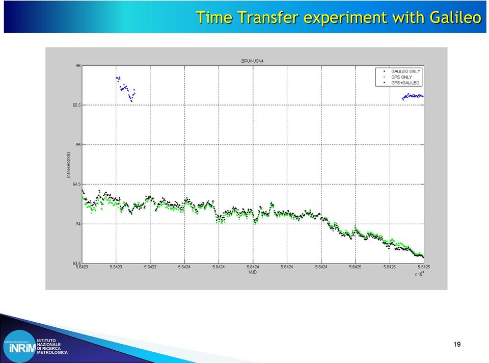
 is evaluated; First experiment with Galileo measurements; GMV PPP is providing results comparable with other geodetic tools in an easy way, coping")
20 Conclusions Evaluation of GMV PPP calibrated estimates for Time (and frequency) Transfer applications; Comparison with other techniques used in timing community; Dependency on network size and distribution products (satellites orbits and clocks) is evaluated; First experiment with Galileo measurements; GMV PPP is providing results comparable with other geodetic tools in an easy way, coping with Time and Frequency Laboratories needs, in terms of monitoring of their atomic clocks and time scales with a reduced latency (through the use of magicgnss ODTS satellite orbits/clocks products). 20

International time scales Atomic standards
 International time scales Atomic standards E.F. Arias International Committee for GNSS, 2 nd Meeting Meeting of GNSS experts Bangalore, 5 September 2007 OUTLINE International coordination for metrology;
SATELLITE TIME-TRANSFER: RECENT DEVELOPMENTS AND PROJECTS
 SATELLITE TIME-TRANSFER: RECENT DEVELOPMENTS AND PROJECTS W. LEWANDOWSKI 1 and J. NAWROCKI 2 1 Bureau International des Poids et Mesures, Sèvres, France e-mail: [email protected] 2 Astrogeodynamical
International Global Navigation Satellite Systems Service
 International Global Navigation Satellite Systems Service IGS Multi-GNSS Experiment IGS M-GEX Call for Participation www.igs.org Response to this Call for Participation in IGS M-GEX via Web Form Submission
Outline: Yb optical frequency standard The fiber link Applications and fundamental physics
 Orologi ottici e link in fibra: metrologia primaria di frequenza e fisica fondamentale. Davide Calonico Physical Metrology Division ISTITUTO NAZIONALE DI RICERCA METROLOGICA [email protected] 1 Outline:
The IGS: A Multi-GNSS Service
 The IGS: A Multi-GNSS Service Chris Rizos, Urs Hugentobler, Ruth Neilan IUGG IAG Structure International Union of Geodesy and Geophysics (IUGG) 65 Member Countries (Adhering Bodies), 8 Associations International
Comparison with GPS Time Transfer and VLBI Time Transfer
 IVS NICT-TDC News No.28 Comparison with GPS Time Trafer and VLBI Time Trafer Hiroshi Takiguchi ([email protected]), Thomas Hobiger, Atsutoshi Ishii, Ryuichi Ichikawa, and Yasuhiro Koyama Kashima Space Research
Time transfer with nanosecond accuracy for the realization of International Atomic Time
 IOP PUBLISHING Metrologia 45 (008) 185 198 METROLOGIA doi:10.1088/006-1394/45//008 Time transfer with nanosecond accuracy for the realization of International Atomic Time D Piester 1, A Bauch 1, L Breakiron,
The European Satellite Navigation Programmes EGNOS and Galileo
 The European Satellite Navigation Programmes EGNOS and Galileo Olivier Crop European GNSS Agency (GSA) Paris, 17 March 2014 20 March, 2014 The European GNSS Programmes 2 Basics of Satellite Navigation
GPS Precise Point Positioning as a Method to Evaluate Global TanDEM-X Digital Elevation Model
 GPS Precise Point Positioning as a Method to Evaluate Global TanDEM-X Digital Elevation Model 7 th FIG Regional Conference TS 1C Advances in GNSS Positioning and Applications I Volker Schwieger 1, Jürgen
Enabling RTK-like positioning offshore using the global VERIPOS GNSS network. Pieter Toor GNSS Technology Manager
 Enabling RTK-like positioning offshore using the global VERIPOS GNSS network Pieter Toor GNSS Technology Manager Introduction PPP/RTK Positioning Techniques PPP-AR Technology Presentation Overview PPP-AR
4-3 Two Way Satellite Time and Frequency Transfer
 4-3 Two Way Satellite Time and Frequency Transfer IMAE Michito, SUZUYAMA Tomonari, GOTOH Tadahiro, SHIBUYA Yasuhisa, NAKAGAWA Fumimaru, SHIMIZU Yoshiyuki, and KURIHARA Noriyuki Two Way Satellite Time and
GPS Precise Point Positioning with a Difference*
 GPS Precise Point Positioning with a Difference* Pierre Héroux and Jan Kouba Geodetic Survey Division, Geomatics Canada Natural Resources Canada 615 Booth Street Ottawa, Ontario K1A E9 [email protected]
DEVELOPMENT OF DEVICES AND METHODS FOR PHASE AND AC LINEARITY MEASUREMENTS IN DIGITIZERS
 DEVELOPMENT OF DEVICES AND METHODS FOR PHASE AND AC LINEARITY MEASUREMENTS IN DIGITIZERS U. Pogliano, B. Trinchera, G.C. Bosco and D. Serazio INRIM Istituto Nazionale di Ricerca Metrologica Torino (Italia)
A NEW ALGORITHM FOR CLOCK WEIGHTS FOR THE SIM TIME SCALE
 Simposio de Metrología 202 8-2 de Octubre, 202 A NEW ALGORITHM FOR CLOCK WEIGHTS FOR THE SIM TIME SCALE 2 J. M. López R, M.A. Lombardi, N. Diaz, E. de Carlos L. División de Tiempo y Frecuencia, Centro
Local monitoring by low cost devices and free and open sources softwares
 Local monitoring by low cost devices and free and open sources softwares Abstract Ludovico Biagi, Florin-Catalin Grec, Marco Negretti, Maria Grazia Visconti Politecnico di Milano, DICA@ComoCampus The purpose
TIME AND FREQUENCY METROLOGY WORKING GROUP Working to support time and frequency metrology throughout the Americas
 J. Mauricio Lopez R. a, Michael A. Lombardi b, Andrew N. Novick b, Jean-Simon Boulanger c, Raymond Pelletier c, Carlos Donado M. d, and Ricardo Carvalho e a Centro Nacional de Metrología (CENAM), Querétaro,
How To Understand Gate
 Time Facility for German Galileo Test Environment GATE J. Furthner, German Aerospace Center () Folie 1, GTFS 2005 > JF Content Overview of GATE Major Objectives of GATE GATE Field Service Area Functions
Online GPS processing services: an initial study
 GPS Solut (2006) 10: 12 20 DOI 10.1007/s10291-005-0147-5 ORIGINAL ARTICLE Reza Ghoddousi-Fard Peter Dare Online GPS processing services: an initial study Received: 15 September 2004 Accepted: 3 May 2005
Supporting Education and Training in the field of Satellite Navigation in Europe. Gabriella Povero. Istituto Superiore Mario Boella
 Supporting Education and Training in the field of Satellite Navigation in Europe Gabriella Povero Istituto Superiore Mario Boella The NavSAS The NavSAS research group is a joint team between Istituto Superiore
GNSS integrity monitoring for the detection and mitigation of interference
 GNSS integrity monitoring for the detection and mitigation of interference Dr. Shaojun Feng Centre for Transport Studies Outline GNSS vulnerability GNSS integrity monitoring Cases study GAARDIAN ERAIM
Time and frequency comparisons using radiofrequency signals from satellites
 Time and frequency comparisons using radiofrequency signals from satellites Author: Andreas Bauch Physikalisch-Technische Bundesanstalt, Bundesallee 100, 38116 Braunschweig Tel.: +49 531 592 4420 E-Mail:
Presentation Outline. The NavSAS group; Examples of Software-Radio Technology in GNSS;
 Telemobility 2008 Progetto Galileo ed altri GNSS Development of GPS-Galileo Galileo Software Radio Receivers Marco Pini - NavSAS group Presentation Outline The NavSAS group; Basic on Software-Radio Technology;
The BIPM, the Time Department and UTC
 The BIPM, the Time Department and UTC Elisa Felicitas Arias Fundamentals for a time and frequency laboratory BIPM, 11 September 2012 BUREAU INTERNATIONAL DES POIDS ET MESURES The BIPM It has headquarters
GFZ prototype for GPS-based realtime deformation monitoring
 GFZ prototype for GPS-based realtime deformation monitoring Junping Chen, Maorong Ge, Markus Vennebusch, Gerd Gendt, Markus Rothacher Department of Geodesy and Remote Sensing, GeoForschungsZentrum, Postdam
PTB S TIME AND FREQUENCY ACTIVITIES IN 2006: NEW DCF77 ELECTRONICS, NEW NTP SERVERS, AND CALIBRATION ACTIVITIES
 Proc. 38th Annual Precise Time and Time Interval (PTTI) Systems and Applications Meeting, Reston, Virginia, USA, 5-7 Dec 2006, pp. 37-47, 2007. PTB S TIME AND FREQUENCY ACTIVITIES IN 2006: NEW DCF77 ELECTRONICS,
Günter Seeber. Satellite Geodesy 2nd completely revised and extended edition
 Günter Seeber Satellite Geodesy 2nd completely revised and extended edition Walter de Gruyter Berlin New York 2003 Contents Preface Abbreviations vii xvii 1 Introduction 1 1.1 Subject of Satellite Geodesy...
Call for applications for one research fellowship for foreign researchers. The President Decrees
 Call for applications for one research fellowship for foreign researchers The President Decrees Art. 1- Overview A selection process is opened to generate a ranked list of candidates on the basis of scientific
A totally SDR-based Low Cost Augmentation System for Institutional Applications
 A totally SDR-based Low Cost Augmentation System for Institutional Applications R. Capua, L. Gattuso, A. Caporale, M. Giangolini, F. Frittella, C. D Amico, D. Tufillaro 21 January 2016 R. Capua DO-11-DO-01
Education and Training in GNSS
 Education and Training in GNSS Mourad BOUZIANI Department of Geodesy and Surveying ESGIT, IAV Hassan II, Morocco Cordinator of GNSS Master Curriculum CRASTE-LF, Affiliated to the United Nations OUTLINE
Remote Calibration of a GPS Timing Receiver to UTC(NIST) via the Internet*
 via the Internet*") Remote Calibration of a GPS Timing Receiver to UTC(NIST) via the Internet* Michael A. Lombardi and Andrew N. Novick National Institute of Standards and Technology Boulder, Colorado [email protected]
Remote Calibration of a GPS Timing Receiver to UTC(NIST) via the Internet* Michael A. Lombardi and Andrew N. Novick National Institute of Standards and Technology Boulder, Colorado [email protected]
GENERAL INFORMATION ON GNSS AUGMENTATION SYSTEMS
 GENERAL INFORMATION ON GNSS AUGMENTATION SYSTEMS 1. INTRODUCTION Navigation technologies with precision approach and landing systems, for civilian and military purposes, enable aircrafts to perform their
HANDBOOK. Measuring System DESIGN EDITORS PETER H. SYDENHAM RICHARD THORN ARTICLE OFFPRINT
 HANDBOOK OF Measuring System DESIGN EDITORS PETER H. SYDENHAM RICHARD THORN ARTICLE OFFPRINT 200: Calibrations and Standards in Time Measurement Michael A. Lombardi National Institute of Standards and
Based on the list above, we can define EGNSS - European GNSS as a Galileo and EGNOS.
 Spis treści 1. What is GNSS?... 2 2. What is e-knot Project?... 4 2.1. Project description... 4 2.2. Partners:... 5 3. e-knot opportunities:... 6 3.1. FOR COMPANIES... 6 3.1.1. Support to PhDs... 6 3.1.2.
EPN Special Project Real-Time Analysis Status Report
 EPN Special Project Real-Time Analysis Status Report Wolfgang Söhne Federal Agency for Cartography and Geodesy (BKG), Germany Highlights Real-time observational data EUREF regional broadcaster Broadcaster
AUTOMATED OPERATIONAL MULTI-TRACKING HIGH PRECISION ORBIT DETERMINATION FOR LEO MISSIONS
 AUTOMATED OPERATIONAL MULTI-TRACKING HIGH PRECISION ORBIT DETERMINATION FOR LEO MISSIONS J. Fernández Sánchez, F. M. Martínez Fadrique, A. Águeda Maté, D. Escobar Antón GMV S.A., Isaac Newton 11, 876 Tres
GNSS permanent stations as the part of integrated geodetic system in Estonia
 GNSS permanent stations as the part of integrated geodetic system in Estonia Karin Kollo (MSc) Department of Geodesy Estonian Land Board United Nations/Croatia Workshop on the applications of Global Navigation
Prof. Ludovico Biagi. Satellite Navigation and Monitoring
 Prof. Ludovico Biagi Satellite Navigation and Monitoring Navigation: trajectories control positions estimations in real time, at high frequency popular applications: low accuracy (10 m) required specific
Greg Keel P.Eng. Parallel Geo Services [email protected]
 Greg Keel P.Eng. Parallel Geo Services [email protected] Presentation Outline GNSS: Global Navigation Satellite System GPS: overview, current signals, modernization GLONASS: history (rise fall rise),
RealtimePPP using EUREF and IGS Networks
 RealtimePPP using EUREF and IGS Networks Georg Weber 1) Leos Mervart 2), Peter Neumaier 1), Andrea Stürze 1) 1) Federal Agency for Cartography and Geodesy, Frankfurt am Main, Germany 2) Technical University
DEVELOPING A MULTI-GNSS ANALYSIS SOFTWARE FOR SCIENTIFIC PURPOSES
 DEVELOPING A MULTI-GNSS ANALYSIS SOFTWARE FOR SCIENTIFIC PURPOSES Michael Meindl (1), Rolf Dach (1), Stefan Schaer (2), Urs Hugentobler (3), Gerhard Beutler (1) (1) Astronomical Institute, University of
Status, Development and Application
 Federal Space Agency GLONASS GLONASS Status, Development and Application Sergey G. Revnivykh International Committee on Global Navigation Satellite Systems (ICG) Second Meeting, September 4-7, 2007, Bangalore,
GNSS seismology for the 2012 M w = 6.1 Emilia Earthquake: exploiting the VADASE algorithm
 GNSS seismology for the 2012 M w = 6.1 Emilia Earthquake: exploiting the VADASE algorithm E. Benedetti 1, M. Branzanti 1, L. Biagi 2, G. Colosimo 1, A. Mazzoni 1 and M. Crespi 1 Corresponding author: E.
Rafael Lucas EUROPEAN SPACE AGENCY. [email protected]
 ESA Navigation Support Facilities Rafael Lucas EUROPEAN SPACE AGENCY [email protected] Background The ESA/ESTEC Radionavigation laboratory was created in 1989 to support the application of
Alberding GNSS data management & monitoring tools
 Alberding GNSS data management & monitoring tools 1/24 Alberding GNSS data management & monitoring tools Tamás Horváth Alberding GmbH EUREF 2013 Symposium, 29-31 May 2013, Budapest, Hungary Alberding GNSS
MULTI-GNSS DEMONTRATION CAMPAIGN IN ASIA OCEANIA REGION
 UNITED NATIONS INTERNATIONAL MEETING ON THE APPLICATIONS OF GLOBAL NAVIGATION SATELLITE SYSTEMS PRESENTATION SESSION 2: INTERNATIONAL INITIATIVES/EXPERIENCES MULTI-GNSS DEMONTRATION CAMPAIGN IN ASIA OCEANIA
Dancing in the Dark: How GNSS Satellites Cross the Earth s Shadow
 Dancing in the Dark: How GNSS Satellites Cross the Earth s Shadow F. Dilssner, T. Springer, G. Gienger, R. Zandbergen European Space Operations Centre (ESOC), Darmstadt 24 January 2011 Technische Universität
The NavSAS Research Group
 Navigation, Signal Analysis and Simulation Group The NavSAS Research Group NavSAS research group is a joint team of Politecnico di Torino and ISMB Research in the areas of satellite navigation and Positioning
REAL-TIME GPS MONITORING OF ATOMIC FREQUENCY STANDARDS IN THE CANADIAN ACTIVE CONTROL SYSTEM (CACS)
") 30th Annual Pmbe Time and Time Internal (PTTI) Meeting REAL-TIME GPS MONITORING OF ATOMIC FREQUENCY STANDARDS IN THE CANADIAN ACTIVE CONTROL SYSTEM (CACS) F. Lahaye, M. Caissy, J. Popelar Geodetic Survey
30th Annual Pmbe Time and Time Internal (PTTI) Meeting REAL-TIME GPS MONITORING OF ATOMIC FREQUENCY STANDARDS IN THE CANADIAN ACTIVE CONTROL SYSTEM (CACS) F. Lahaye, M. Caissy, J. Popelar Geodetic Survey
THE CURRENT EVOLUTIONS OF THE DORIS SYSTEM
 THE CURRENT EVOLUTIONS OF THE DORIS SYSTEM TAVERNIER, G.; GRANIER, J.P.; JAYLES, C.; SENGENES, P. (CNES) ROZO, F. (COFRAMI) presented by P. VINCENT (CNES) Table of Contents System and Missions Satellites:
Real-Time GNSS in Routine EPN Operations Concept
 Real-Time GNSS in Routine EPN Operations Concept EPN Real-time Working Group D. Dettmering, G. Weber, C. Bruyninx, H. v.d.marel W. Gurtner, J. Torres, A. Caporali Status: December 3, 2006 1 CONTENT 1 Introduction
CRITERIA FOR PERFORMING CALIBRATION AND INTERMEDIATE CHECKS ON EQUIPMENT USED IN ACCREDITED FACILITIES
 CRITERIA FOR PERFORMING CALIBRATION AND INTERMEDIATE CHECKS ON EQUIPMENT USED IN ACCREDITED FACILITIES Prepared by: Technical Manager Approved by: Chief Executive Officer Approval Date: 2013-04-24 Effective
EXECUTIVE SUMMARY TFD-TN-CGS-004
 New Methods and Systems for Time and Frequency Distribution via Satellite Issue ESTEC Contract N. 1447/00/NL/PB Space Engineering S.p.A. TIME AND FREQUENCY Tipo Doc.: Doc.Type: N Doc.: Doc. N : TECHNICAL
The European GNSS Programmes EGNOS and Galileo
 The European GNSS Programmes EGNOS and Galileo 6th ICG Conference Pieter De Smet European Commission 5 September 2011 1. State of Play of EGNOS 2. State of Play of Galileo 5 September, 2011 The European
Clocks/timers, Time, and GPS
 FYS3240 PC-based instrumentation and microcontrollers Clocks/timers, Time, and GPS Spring 2015 Lecture #11 Bekkeng, 22.12.2014 How good is a crystal oscillator (XO)? Interested in the long-term measurement
Introduction into Real-Time Network Adjustment with Geo++ GNSMART
 Introduction into Real-Time Network Adjustment with Geo++ GNSMART Andreas Bagge Gerhard Wübbena, Martin Schmitz Geo++ GmbH D-30827 Garbsen, Germany www.geopp.de GeoInformation Workshop 2004, Istanbul Kultur
GNSS GROUP DELAY VARIATIONS - POTENTIAL FOR IMPROVING GNSS BASED TIME AND FREQUENCY TRANSFER?
 GNSS GROUP DELAY VARIATIONS - POTENTIAL FOR IMPROVING GNSS BASED TIME AND FREQUENCY TRANSFER? Tobias Kersten and Steffen Schön Institut für Erdmessung (IfE) Leibniz Universität Hannover Schneiderberg 50,
EUTERPE - EUROPEAN TEST CENTRE FOR RECEIVER PERFORMANCE EVALUATION
 ABSTRACT EUTERPE - EUROPEAN TEST CENTRE FOR RECEIVER PERFORMANCE EVALUATION David Jiménez-Baños (1), Michel Tossaint (1), Jean-Luc Gerner (1), Rafael Lucas-Rodríguez (2) (1) Radio Navigation Systems and
The Use and Integrity Monitoring of IGS Products at Geoscience Australia (GA)
") Australian Government Geoscience Australia The Use and Integrity Monitoring of IGS Products at Geoscience Australia (GA) Ramesh Govind, John Dawson, John Manning IGS-2004 Workshop and Symposium Berne,
Australian Government Geoscience Australia The Use and Integrity Monitoring of IGS Products at Geoscience Australia (GA) Ramesh Govind, John Dawson, John Manning IGS-2004 Workshop and Symposium Berne,

Why do we need to improve co-locations of space geodetic techniques?
 Why do we need to improve co-locations of space geodetic techniques? Zuheir Altamimi & Xavier Collilieux IGN France 1 Outline ITRF Heritage Current status of technique networks & co-locations Results from
Leica AR25 White Paper
 Leica AR25 White Paper February 2009 Lennon Bedford, Neil Brown, Justin Walford Leica Geosystems AG Heerbrugg, Switzerland 2 Biography Lennon Bedford graduated from the University of Otago in 2003 with
Chapter 6: distributed systems
 Chapter 6: distributed systems Strongly related to communication between processes is the issue of how processes in distributed systems synchronize. Synchronization is all about doing the right thing at
Recent Activities of the SGO Local Analysis Centre
 Recent Activities of the SGO Local Analysis Centre Tamás Jambor [email protected], Ambrus Kenyeres [email protected] Satellite Geodetic Observatory, Institute of Geodesy, Cartography and Remote Sensing
Update of BeiDou Education and Training
 Update of BeiDou Education and Training Introduction Activities in 2014 GNSS education and training facility Future plan Introduction Beidou International Exchanging and Training Center is affiliated to
GNSS satellite attitude characteristics during eclipse season
 GNSS satellite attitude characteristics during eclipse season F. Dilssner 1, T. Springer 1, J. Weiss 2, G. Gienger 1, W. Enderle 1 1 ESA/ESOC, Darmstadt, Germany 2 JPL, Pasadena, USA July 26, 2012 IGS
AFREF First GNSS Station : Lessons learnt Building up a Continental Reference Frame
 AFREF First GNSS Station : Lessons learnt Building up a Continental Reference Frame Joel van Cranenbroeck, Director of Technology and Project Development Leica Geosystems AG, Geomatic Division CH-9435
International Committee on Global Navigation Satellite Systems and its Programme on the Applications of Global Navigation Satellite Systems
 International Committee on Global Navigation Satellite Systems and its Programme on the Applications of Global Navigation Satellite Systems Sharafat Gadimova United Nations Office for Outer Space Affairs
OPTICAL CLOCKS IN FUTURE GLOBAL NAVIGATION SATELLITES
 OPTICAL CLOCKS IN FUTURE GLOBAL NAVIGATION SATELLITES U. Hugentobler (1), M. Plattner (2), S. Bedrich (2), M. Heinze (1), V. Klein (2), D. Voithenleitner (1) (1) Technische Universität München. Arcisstrasse
European Geodetic Status European Geodetic Reference Systems
 European Geodetic Status European Geodetic Reference Systems Reporter: Hansjörg Kutterer, Federal Agency of Cartography and Geodäsie (BKG), Germany Contributors to this report: Johannes Ihde, Federal Agency
Guidelines for RTK/RTN GNSS Surveying in Canada
 Guidelines for RTK/RTN GNSS Surveying in Canada July 2013 Version 1.1 Ministry of Transportation Ministère des Transports EARTH SCIENCES SECTOR GENERAL INFORMATION PRODUCT 100-E Main Authors: Brian Donahue,
GAL Project Galileo for Gravity
 GAL Project Galileo for Gravity Galileian Plus srl via Tiburtina 755 00159 Roma Angelo Amodio ([email protected]) Collaborative Project Grant # 287193 GAL Project Call identifier: FP7-GALILEO-2011-GSA-1-a,
CDMA Technology : Principles of CDMA/DS Decoding
 CDMA Technology : Principles of CDMA/DS Decoding Pr. Dr. W.Skupin www.htwg-konstanz.de Pr. S.Flament www.greyc.fr/user/99 On line Course on CDMA Technology CDMA Technology : Introduction to Spread Spectrum
GRUAN Station Report for Potenza
 WMO/IOC/UNEP/ICSU GLOBAL CLIMATE OBSERVING SYSTEM (GCOS) 7th GRUAN Implementation- Coordination Meeting (ICM-7) Matera, Italy 23 February 27 February 2015 Doc. 8.12 (11.II.2015) Session 8 GRUAN Station
Permanent GNSS station network and AlpCheck: freight transport monitoring
 Permanent GNSS station network and AlpCheck: freight transport monitoring 19 th June 2008 Giorgio Gaber Auditorium Palazzo della Regione Lombardia MILAN Francesco Matonti IREALP Project summary Problems
Threats of Ionosphere on GNSS an general overview of CIGALA and CALIBRA Projects
 Threats of Ionosphere on GNSS an general overview of CIGALA and CALIBRA Projects João Francisco Galera Monico Vinícius Stuani Presentation Outline Threats of Ionosphere on GNSS o Ionosphere effects and
CDMA Technology : Pr. S. Flament www.greyc.fr/user/99. Pr. Dr. W. sk www.htwg-konstanz.de. On line Course on CDMA Technology
 CDMA Technology : Pr. Dr. W. sk www.htwg-konstanz.de Pr. S. Flament www.greyc.fr/user/99 On line Course on CDMA Technology CDMA Technology : CDMA / DS : Principle of operation Generation of PN Spreading
PRESENTATION SPACE MISSIONS
 GENERAL PRESENTATION SPACE MISSIONS CONTENTS 1. Who we are 2. What we do 3. Space main areas 4. Space missions Page 2 WHO WE ARE GENERAL Multinational conglomerate founded in 1984 Private capital Offices
Securing GNSS with PTP & SyncE Adam Wertheimer Microsemi [email protected]. Power Matters
 Securing GNSS with PTP & SyncE Adam Wertheimer Microsemi [email protected] Power Matters Introduction Base stations and other end nodes need reliable synchronization Typically GPS was used
Fundamental to determining
 GNSS Solutions: Carrierto-Noise Algorithms GNSS Solutions is a regular column featuring questions and answers about technical aspects of GNSS. Readers are invited to send their questions to the columnist,
GNSS MONITORING NETWORKS
 SPACE GNSS MONITORING NETWORKS Satellite communications, earth observation, navigation and positioning and control stations indracompany.com GNSS MONITORING NETWORKS GNSS MONITORING NETWORKS Indra s solutions
Towards Real-time GNSS Troposphere Delay Monitoring Service for Poland
 Towards Real-time GNSS Troposphere Delay Monitoring Service for Poland Tomasz Hadas, Kaplon Jan, Bosy Jaroslaw Institute of Geodesy and Geoinformatics Wroclaw University of Environmental and Life Sciences
Provide network RTK Services in a few simple steps
 RTRef System Provide network RTK Services in a few simple steps What is RTRef? RTRef is a software system to provide GNSS network corrections for accurate positioning. The system includes a web-based interface
 IMES (Indoor Messaging System) A Proposal for New Indoor Positioning System Presenter: Dr. Dinesh Manandhar GNSS Technologies Inc., Japan Third Meeting of the International Committee on Global Navigation
Overview of UN Programme on Space Applications and Its Tele-Health Activities
 Expert Meeting for the United Nations/India/USA Pilot Project Telemedicine in the Reconstruction of Afghanistan 29-31 August 2006 Amritha Institute of Medical Sciences. Cochin, India Overview of UN Programme
Fundamentals of Time and Frequency
 17 Fundamentals of Time and Frequency Michael A. Lombardi National Institute of Standards and Technology 17.1 Introduction Coordinated Universal Time (UTC) 17.2 Time and Frequency Measurement Accuracy
TWO-WAY SATELLITE TIME TRANSFER TO A MOVING PLATFORM
 33rd Annual Precise Time and Time Interval (PPI) Meeting TWO-WAY SATELLITE TIME TRANSFER TO A MOVING PLATFORM Edward Powers U.S. Naval Observatory Washington, DC 20392, USA E-mail: po [email protected]
RECOMMENDATION. on the Evaluation of Quality Management System of National Metrology Institutes
 EURO-ASIAN COOPERATION OF NATIONAL METROLOGICAL INSTITUTIONS COOMET ЕВРО-АЗИАТСКОЕ СОТРУДНИЧЕСТВО ГОСУДАРСТВЕННЫХ МЕТРОЛОГИЧЕСКИХ УЧРЕЖДЕНИЙ КООМЕТ Approved on the COOMET Quality Forum 25 th February 2002
Time and frequency distribution using satellites
 INSTITUTE OF PHYSICS PUBLISHING Rep. Prog. Phys. 65 (2002) 1119 1164 REPORTS ON PROGRESS IN PHYSICS PII: S0034-4885(02)98967-0 Time and frequency distribution using satellites Judah Levine Time and Frequency
GPS BLOCK IIF RUBIDIUM FREQUENCY STANDARD LIFE TEST
 GPS BLOCK IIF RUBIDIUM FREQUENCY STANDARD LIFE TEST F. Vannicola, R. Beard, J. White, K. Senior, T. Kubik, D. Wilson U.S. Naval Research Laboratory 4555 Overlook Avenue, SW, Washington, DC 20375, USA E-mail:
GNSS satellites as co-locations for a combined GNSS and SLR analysis
 GNSS satellites as co-locations for a combined GNSS and SLR analysis D. Thaller 1), K. Sośnica 1), R. Dach 1), A. Jäggi 1), M. Mareyen 2), B. Richter 2), G. Beutler 1) (1) Astronomical Institute, University