Das Copernicus Collaborative GroundSegment des DLR
|
|
|
- Donald Stanley
- 8 years ago
- Views:
Transcription
1 Das Copernicus Collaborative GroundSegment des DLR Gunter Schreier Deutsches Fernerkundungsdatenzentrum DFD Earth Observation Center EOC DLR November 2015

2 Earth Observation Center DLR German Aerospace Center Research Institution Space Agency Project Management Agency Aeronautics Space Research and Technology Transport Energy Defence and Security 2/11

3 DLR Earth Observation Center Earth Observation Center Oberpfaffenhofen Neustrelitz Bremen Berlin Inuvik, Kanada O Higgins, Antarktis Institut für Methodik der Fernerkundung (IMF) Direktor: Richard Bamler Deutsches Fernerkundungsdatenzentrum DFD) Direktor: Stefan Dech 3/11
")
4 Earth Observation Center April 3rd, /11

5 Earth Observation Center Global Monitoring of Environment and Security Copernicus The European Earth Observation Programme 5/11

6 Die Sentinel Missionen Earth Observation Center Sentinel 1 SAR imaging a Sentinel 2 Multispectral imaging a 23. Juni b c d b c d Sentinel 3 Ocean and global land monitoring a Sentinel 4 Geostationary Atmosphere Payload on EUMETSAT geostationary S5 Precursor Sentinel 5 Low-orbit Atmosphere/ Air quality Payload on EUMETSAT polar orbiting Sentinel 6 Low-orbit Altimetry CNES JASON heritage b c d 6/11

7 Sentinel-1 Copernicus processed at D-PAC


8 Earth Observation Center Copernicus Kern Nutzlast - Bodensegment 8/11

9 > DLR-Standardfoliensatz > Januar 2012.de Inuvik Ground Station, Canadian Arctic Folie 9 Earth Observation Center 9/11

10 Earth Observation Center Deutsches Satelliten Daten Archiv 50 (+33) PetaByte storage capacity About 1,5 PetaByte of product data per year per Sentinel Deutsches Satellitendatenarchiv(D-SDA); Kapazität: 50 PB für nationale und Sentinel-Missionsdaten Deutsches Fernerkundungsdatenzentrum 10/11


11 Earth Observation Center Global Monitoring of Environment and Security Geoinformations-Dienste Core & Collaborative 11/11


12 Earth Observation Center Copernicus: Die Kerndienste von Copernicus - Krisen- und Notfallkartierung - Landoberfläche - Marine Anwendungen - Zivile Sicherheit - Atmosphäre - Klimawandel 12/11

13 Earth Observation Center Maritime Sicherheit WV2 acquisition of the Costa Concordia. (19 Jan 2012) (c) DigitalGlobe, provided by European Space Imaging 13/11
 (c) DigitalGlobe,")


14 Meeresoberflächenparameter aus Satelliten- Radar Earth Observation Center Wind Seegang Öl Land-Wasser Line Strömungen Schiffe Bathymetrie Wellenbrechen Einzelwellen Meereis Sentinel-1 Radarsat-2 14/11

15 Earth Observation Center Wind & Wellen gerechnet aus Satellitendaten Aug. 23, 2012, 05:51 UTC, TerraSAR-X Stripmap 15/11

16 de Chart 16 > Vortrag > Autor Dokumentname > Datum Earth Observation Center 16/11

17 Chart 17 > Vortrag > Autor Dokumentname > Datum

18 Earth Observation Center Page 18 18/11
19 Earth Observation Center Forschungstellen Maritime Sicherheit des DLR Nahe Echtzeit-Dienste aus Neustrelitz 19/11

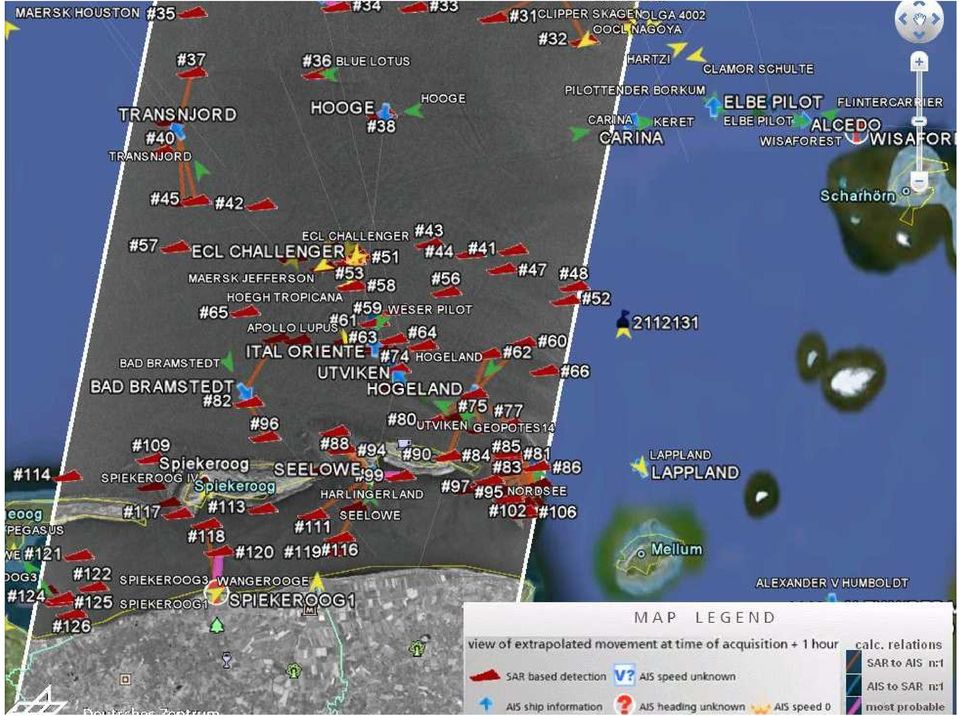
20 Earth Observation Center Sentinel-1 Empfangen und verarbeitet durch DLR Neustrelitz 20/11

21 Page 21 Earth Observation Center European Data Relay Satellite EDRS 21/11
22 Nahe Echtzeit Demo: Aufnahme, Empfang, Verarbeitung Earth Observation Center LCT-Link und Datenempfang Neustrelitz Oberpfaffenhofen Empfangin Oberpfaffenhofenvia Alphasat Ka- Band Antenne L0 Verarbeitungin Oberpfaffenhofen Alphasat Transfer nach Neustrelitz und nahe Echtzeit Verarbeitung zu maritimen Produkten 22/11
23 EMSA NRT Demo: L2 ship detection product at Google Earth Earth Observation Center E2E time from Alphasatdownlink to availability of value added product 18 min ( ) 23/11
24 Tsunami japanese: 津 波, wave in harbor; 津 tsu, harbor und 波 nami, wave Naturkatastrophen Notfallkartierung

25
26 SENDAI change map TerraSAR-X, March 12, 2011 (c) DLR - ZKI
27 de Chart 27 Earth Observation Center 27
28
29 Chart 29
30 Messung von Bewegungen durch differentielle Interferometrie Erdbeben Nepal (April 2015 Sentinel 1)
31 International Charter on Space and Major Disasters An International agreement among participating Space Agencies to provide spacebased data and information in support of relief efforts during emergencies caused by major disasters.
32 Earth Observation Center Center for Satellite-based Crisis Information - ZKI National Service ZKI-DE 32/11
33 Flüchtlingslager Al Zaatari Quelle THW
34 Helfer vor Ort
35 Deutsches Fernerkundungsdatenzentrum Al Zaatari, Jordanien
36 Deutsches Fernerkundungsdatenzentrum Urbaner Planet Urbane und ländliche Bevölkerung Vergangenheit und Zukunftsprognosen (UN, 2012) 36/ 18
37 Deutsches Fernerkundungsdatenzentrum Hong-Kong Kowloon 37/ 18
38 15 km
39
40
41 Chart 41 Motivation Erbertseder et al., 2014 NO 2 distribution 2012 and trend in Pearl river delta region, measured with SCIA time series data
42 Earth Observation Center Global Urban Footprint Binäre Maske aller künstlichen (vertikalen) Strukturen RäumlicheAuflösung 0.4 arcsec(12.5 m) Globale Abdeckung durch ~ TerraSAR-X und TanDEM-X Datensätze (~300 TB). SAR Datenerhebung durch TerraSAR-X und TanDEM-X zwischen 2011 und 2013; Weltbank 42
43 Global Urban Footprint TanDEM-X Deutschland


44 Earth Observation Center Erdbeobachtung 4.0 Big Data Quelle: ESA
45 Big Data Computing at EOC: GeoFarm GeoFarm Extension 2016 >4300 Cores >33 TB RAM >1,9 PB Storage (HDD & SSD) Copernicus DLR > 2,7 PB Sentinel product data/ Yr * > 2 * 10 Gbit network connection > 50 PB long term archive capacity ** 10 TB is the digitized capacity of the about 130 Mio books in the US Library of Congress. LoC (~ 2000) ~ 280 LoC ** ~ 5120 LoC - in-house private cloud for internal large scale EO computing - open for projects with partners (no public cloud ) - platform for demonstration of cloud technologies for EO - DLR precursor for larger installations at the envisaged Copernicus Center
46 Collaborative Ground Segment - Interfacing Earth Observation Center Copernicus Core Ground Segment and Services National Collaborative Ground Segment Copernicus Service Entities EO Data Users Exploitation Entities and Cloud Providers Copernicus Data Access and Exploitation Collaborative Infrastructure CGS MPC circulation network CQC POD dissemination network PAC Data Hub Portals Data and Product Access Archive Ingestion Information Systems & Services Processing Sentinel Core PDGS Acquisition Station, EDRS Third Party Data 46/11
47 German Copernicus Center For a strong Earth Observation in Germany and Europe Earth Observation Center 47/11
48 Earth Observation Center Gunter Schreier Earth Observation Center EOC DLR Oberpfaffenhofen, Germany 48/11
49 Earth Observation Center 49/11
German Earth Observation Systems and Programs Capacities for nation building
 German Earth Observation Systems and Programs Capacities for nation building German Aerospace Center, DLR, Earth Observation Center, EOC German Remote Sensing Data Center, DFD Gunter Schreier Deputy Director
New Space Capabilities for Maritime Surveillance
 www.dlr.de ESA Blue Growth Marititime College, Cork, Ireland 17.4..2013 New Space Capabilities for Maritime Surveillance Susanne Lehner German Aerospace Center DLR Remote Sensing Technology Institute DLR
SAR Measurements of Wind Field, Sea State Topography at Offshore Platforms
 SAR Measurements of Wind Field, Sea State Topography at Offshore Platforms Susanne Lehner DLR, Oberpfaffenhofen Susanne.Lehner@dlr.de Planned NRT Products ENVISAT Wind Sea State OIl Land-Water Line Ships
Deutsches Fernerkundungsdatenzentrum Nationales Bodensegment Neustrelitz. Holger Maass. Storagetechnology 2008 4.-6. Juni 2008, Fleesensee
 Deutsches Fernerkundungsdatenzentrum Nationales Bodensegment Neustrelitz Holger Maass Storagetechnology 2008 4.-6. Juni 2008, Fleesensee German Remote Sensing Data Center ( DFD ) with 2 locations in Germany
The DLR Satellite Station in Inuvik a Milestone for the Canadian-German Cooperation in Earth Observation
 The DLR Satellite Station in Inuvik a Milestone for the Canadian-German Cooperation in Earth Observation Erhard Diedrich German Remote Sensing Data Center DFD EOC German Aerospace Center DLR May 2016 DLR
Best Practice: GMES Activities at DLR
 Best Practice: GMES Activities at DLR German Aerospace Center, DLR, Earth Observation Center, EOC German Remote Sensing Data Center, DFD Gunter Schreier Deputy Director Prague, CZ, May 29th, 2012 Folie
The DLR Multi Mission EO Ground Segment
 The DLR Multi Mission EO Ground Segment Payload Ground Segment Erhard Diedrich Remote Sensing Workshop Mexico 22-24 April 2008 DLR Ground Segment for Earth Observation: Servicing GMES, national and commercial
Prediction of Storm Surge using Space Data. Susanne Lehner German Aerospace Center
 Prediction of Storm Surge using Space Data Susanne Lehner German Aerospace Center Existing Crisis Information State of the Art of Satellite Crisis Information (ZKI) Mapping after the storm www.zki.de
Current Status and Considerations for the Future. Harald Mehl & Stefan Voigt German Aerospace Center (DLR)
") Current Status and Considerations for the Future Harald Mehl & Stefan Voigt German Aerospace Center (DLR) Supporting DLR s engagement in EO for civil security Contribution to the implementation of the
Current Status and Considerations for the Future Harald Mehl & Stefan Voigt German Aerospace Center (DLR) Supporting DLR s engagement in EO for civil security Contribution to the implementation of the
German Antarctic Receiving Station GARS O Higgins: Remote sensing as core for a broader range of activities
 DLR.de Chart 1 > Kathrin Hoeppner > EU-Chile-Workshop > November 28-29, 2013 > Punta Arenas, Chile German Antarctic Receiving Station GARS O Higgins: Remote sensing as core for a broader range of activities
Remote Sensing Applications in Support of Sustainable Development and Disaster Management by DLR Current Activities
 Remote Sensing Applications in Support of Sustainable Development and Disaster Management by DLR Current Activities Dr. Günter Strunz German Aerospace Center (DLR) German Remote Sensing Data Center 43rd
How To Write A Call To Action For Terrasar-X
 Doc.: TX-PGS-PL-4127 TerraSAR-X Announcement of Opportunity: Utilization of the TerraSAR-X Archive 1 Page: 2 of 11 TABLE OF CONTENTS TERRASAR-X... 1 ANNOUNCEMENT OF OPPORTUNITY: UTILIZATION OF THE TERRASAR-X
Real Time Services for Space Applications Holger Maass, Susanne Lehner
 Real Time Services for Space Applications Holger Maass, Susanne Lehner Holger.Maass@dlr.de German Remote Sensing Data Center ( DFD ) with 2 locations in Germany Neustrelitz in Mecklenburg-Vorpommern Oberpfaffenhofen
Update on Capacity Building Activities at DLR s Earth Observation Center EOC. WGCapD-3 Annual Meeting, Dehradun, India
 www.dlr.de Chart 1 WGCapD-3 Annual Meeting Dehradun/India Dieter Hausamann EO School Lab Update on Capacity Building Activities at DLR s Earth Observation Center EOC WGCapD-3 Annual Meeting, Dehradun,
Data and Information Management for EO Data Centers. Eberhard Mikusch German Aerospace Center - German Remote Sensing Data Center
 Data and Information Management for EO Data Centers Eberhard Mikusch German Aerospace Center - Mexico, 23. 04 2008 Earth Observation System Environment at DLR/DFD 10010 00101 Radar 10010 00101 Atmospheric
Sentinel-1 Mission Overview
 Sentinel-1 Mission Overview Pierre Potin Sentinel-1 Mission Manager, ESA Advanced Course on Radar Polarimetry ESRIN, Frascati, 19 January 2011 Global Monitoring for Environment and Security GMES is established
Combining automated satellite based flood mapping with exposure mapping for flood risk assessment and management
 DLR.de Chart 1 > United Nations/Germany Expert Meeting > A. Twele and F. Hummel > 05 06 2014 Combining automated satellite based flood mapping with exposure mapping for flood risk assessment and management
Status Report DFD 2007 2013. German Remote Sensing Data Center. Deutsches Fernerkundungsdatenzentrum
 Status Report DFD 2007 2013 German Remote Sensing Data Center Deutsches Fernerkundungsdatenzentrum Status Report 2007 2013 Publisher Deutsches Zentrum für Luft- und Raumfahrt e.v. German Aerospace Center
ESA Climate Change Initiative contributing to the Global Space-based Architecture for Climate Monitoring
 ESA Climate Change Initiative contributing to the Global Space-based Architecture for Climate Monitoring Pascal Lecomte Head of the ESA Climate Office ESA/ECSAT Global Space-based Architecture for Climate
TerraSAR X and TanDEM X satellite missions update & other activities Dana Floricioiu German Aerospace Center (DLR), Remote Sensing Technology
, Remote Sensing Technology") TerraSAR X and TanDEM X satellite missions update & other activities Dana Floricioiu German Aerospace Center (DLR), Remote Sensing Technology Institute, Oberpfaffenhofen, Germany PSTG 2 12 14 June 2012
TerraSAR X and TanDEM X satellite missions update & other activities Dana Floricioiu German Aerospace Center (DLR), Remote Sensing Technology Institute, Oberpfaffenhofen, Germany PSTG 2 12 14 June 2012
Satellites for Terrain Motion Mapping Terrafirma User Workshop Mining. Nico Adam
 Satellites for Terrain Motion Mapping Terrafirma User Workshop Mining Nico Adam Outline SAR / InSAR observation characteristic Sensors TSX, TDX ERS-1, ERS-2 Processing techniques D-InSAR PSI SBAS Acquisition
Status Report DFD 2007 2013. German Remote Sensing Data Center. Deutsches Fernerkundungsdatenzentrum
 Status Report DFD 2007 2013 German Remote Sensing Data Center Deutsches Fernerkundungsdatenzentrum Status Report 2007 2013 Publisher Deutsches Zentrum für Luft- und Raumfahrt e.v. German Aerospace Center
TerraSAR-X Nutzlastbodensegment
 TerraSAR-X Nutzlastbodensegment Holger Maass, DLR Neustrelitz GeoForum Warnemünde, 18./19.4.2007 Bodensegment: Die GMES Infrastruktur GMES Geoinformations- Dienste Kommerziell Öffentlich Wissenschaft Gemeinsame
European Space Agency EO Missions. Ola Gråbak ESA Earth Observation Programmes Tromsø, 17 October 2012
 European Space Agency EO Missions Ola Gråbak ESA Earth Observation Programmes Tromsø, 17 October 2012 Europe and Space, A POLICY Article 189 of the Lisbon Treaty (2009) gives the European Union an explicit
TerraSAR-X Interferometry. Michael Eineder, Nico Adam Remote Sensing Technology Institute
 TerraSAR-X Interferometry Michael Eineder, Nico Adam Remote Sensing Technology Institute TerraSAR-X Contribution to Commissioning Phase: verify phase and geometric stability of instrument and SAR processor
LANDSAT 7 - GROUND SEGMENT ACTIVITIES AT THE GERMAN REMOTE SENSING DATA CENTER. Deutsches Fernerkundungsdatenzentrum (DFD) DLR (*)
 DLR (*)") LANDSAT 7 - GROUND SEGMENT ACTIVITIES AT THE GERMAN REMOTE SENSING DATA CENTER Günter Strunz (*), Hans-Dietrich Bettac (**), Jörg Gredel (*), Klaus-Dieter Reiniger (*) & Gunter Schreier (*) Deutsches Fernerkundungsdatenzentrum
LANDSAT 7 - GROUND SEGMENT ACTIVITIES AT THE GERMAN REMOTE SENSING DATA CENTER Günter Strunz (*), Hans-Dietrich Bettac (**), Jörg Gredel (*), Klaus-Dieter Reiniger (*) & Gunter Schreier (*) Deutsches Fernerkundungsdatenzentrum
EO INSTITUTIONAL PERSPECTIVE
 EO INSTITUTIONAL PERSPECTIVE Emilio Vez Rodríguez CDTI 8 th September 2014 Agenda Global overview Figures, markets and main actors The European landscape: Development models Copernicus The role of ESA
Enhancing global Cooperation in satellite based Emergency Mapping
 Enhancing global Cooperation in satellite based Emergency Mapping Dr. Stefan Voigt German Aerospace Center - DLR Center for Satellite based Crisis Information - ZKI DLR Background DLR strongly engages
Update on EUMETSAT ocean colour services. Ewa J. Kwiatkowska
 Update on EUMETSAT ocean colour services Ewa J. Kwiatkowska 1 st International Ocean Colour Science meeting, 6 8 May, 2013 EUMETSAT space data provider for operational oceanography Operational data provider
Fundamentals of Earth Observation Policy: Examples for German and European Missions. Abstract
 International Symposium on Space Policy and Coordination Framework Technical Session 1 Organized during Map Middle East 2010. 23rd March 2010, Abu Dhabi Fundamentals of Earth Observation Policy: Examples
DATA ACCESS AT EUMETSAT
 1 EUM/OPS/VWG/15/793789 v1a DATA ACCESS AT EUMETSAT Copernicus Climate Data Store Workshop ECMWF 3-6 March 2015 Harald Rothfuss Overview of Presentation 1. Introduction to EUMETSAT 2. EUMETSAT Data Access
Marine route optimization. Jens Olaf Pepke Pedersen Polar DTU / DTU Space www.polar.dtu.dk www.space.dtu.dk
 Marine route optimization Jens Olaf Pepke Pedersen Polar DTU / DTU Space www.polar.dtu.dk www.space.dtu.dk Early attempt at route optimization Jens Munk (1579-1628) Tries to find a way to India through
Sentinels Operations Konzept und Prinzipien des Datenzugangs - Copernicus Space Component Data Access Overview
 Sentinels Operations Konzept und Prinzipien des Datenzugangs - Copernicus Space Component Data Overview B. Hoersch Ground Segment and Mission Operations Department, Earth Observation Programmes Directorate,
Comparison of ALOS-PALSAR and TerraSAR-X Data in terms of Detecting Settlements First Results
 ALOS 2008 Symposium, 3-7 November Rhodes, Greece Comparison of ALOS-PALSAR and TerraSAR-X Data in terms of Detecting Settlements First Results Thomas Esch*, Achim Roth*, Michael Thiel, Michael Schmidt*,
From Whitehall to orbit and back again: using space in government
 From Whitehall to orbit and back again: using space in government 18 th June 2014 Bristol 25 th June 2014 Liverpool 3 rd July 2014 -Newcastle Space for Smarter Government Programme (ssgp@sa.catapult.org.uk)
ROSA ESA - DLR Course 2009 RADAR REMOTE SENSING Day 4-5
 ROSA ESA - DLR Course 2009 RADAR REMOTE SENSING Day 4-5 Dr. Jan-Peter Mund, André Twele & Sandro Martinis German Remote Sensing Data Center (DFD) German Aerospace Center (DLR) RADAR REMOTE SENSING Introduction
 This Slide Left Blank NASA APPEL Driving towards PM 2.0? Dr. Terry Cooke-Davies Group Chairman Human Systems International Limited Human Systems International Limited 1987 2011 All Rights Reserved 1 Benchmarking
Thematic Area Water. WP3 - Risk assessment and early warning systems. Task 002 - Remote sensing applications for flood risk management
 Thematic Area Water WP3 - Risk assessment and early warning systems Task 002 - Remote sensing applications for flood risk management German Aerospace Center (DLR) Matthias Mück / Joachim Post Remote Sensing
Satellite Derived Dynamic Ocean Currents in the Arctic. Jens Olaf Pepke Pedersen Polar DTU / DTU Space www.polar.dtu.dk www.space.dtu.
 Satellite Derived Dynamic Ocean Currents in the Arctic Jens Olaf Pepke Pedersen Polar DTU / DTU Space www.polar.dtu.dk www.space.dtu.dk Benefits of exploiting ocean currents Benjamin Franklins map of the
A Future Scenario of interconnected EO Platforms How will EO data be used in 2025?
 A Future Scenario of interconnected EO Platforms How will EO data be used in 2025? ESA UNCLASSIFIED For Official Use European EO data asset Heritage missions Heritage Core GS (data preservation, curation
LCTS ON ALPHASAT AND SENTINEL 1A: IN ORBIT STATUS OF THE LEO TO GEO DATA RELAY SYSTEM
 LCTS ON ALPHASAT AND SENTINEL 1A: IN ORBIT STATUS OF THE LEO TO GEO DATA RELAY SYSTEM H. Zech 1, F. Heine 1, D. Tröndle 1, P. M. Pimentel 1, K. Panzlaff 1, M. Motzigemba 1, R. Meyer 2, S. Philipp-May 2
On data quality in the generation of products, tools, and services
 On data quality in the generation of products, tools, and services Bojan R. Bojkov Head, Sensor Performance, Products and Algorithms Directorate of Earth Observation Programmes European Space Agency (ESA/ESRIN)
EO data hosting and processing core capabilities and emerging solutions
 EO data hosting and processing core capabilities and emerging solutions Andrew Groom 4 th March 2015 Contents An introduction to Airbus Defence and Space, Geo-Intelligence Elements of the C3S vision EO
Sentinel-3 Marine Test Data Set processed at EUMETSAT
 Sentinel-3 Marine Test Data Set processed at EUMETSAT Doc.No. : EUM/TSS/TEN/15/822144 Issue : v2 e-signed Date : 15 December 2015 WBS/DBS : EUMETSAT Eumetsat-Allee 1, D-64295 Darmstadt, Germany Tel: +49
ICSU/WMO World Data Center for Remote Sensing of the Atmosphere (WDC RSAT)
") ICSU/WMO World Data Center for Remote Sensing of the Atmosphere (WDC RSAT) Beate Hildenbrand (et al.) German Aerospace Center (DLR) GAW 2009, Geneva, 05 07 May 2009 http://wdc.dlr.de WDC RSAT overview
ICSU/WMO World Data Center for Remote Sensing of the Atmosphere (WDC RSAT) Beate Hildenbrand (et al.) German Aerospace Center (DLR) GAW 2009, Geneva, 05 07 May 2009 http://wdc.dlr.de WDC RSAT overview
ESA Earth Observation and the need for high speed networking
 ESA Earth Observation and the need for high speed networking Pisa, 11 th May 25 11 th May 25 GARR Conference 5 1 ESA Earth Observation 11 th May 25 GARR Conference 5 2 The European Space Agency The European
DLR contribution to the UNECE Conference
 DLR contribution to the UNECE Conference Water Unites Strengthening Regional Cooperation on Water Management in Central Asia, Almaty 17-18.11.08 Environmental Monitoring, Information Management, Decision
Towards Operational Monitoring of the Baltic Sea by Remote Sensing
 G. Schernewski & N. Löser (eds.): Managing the Baltic Sea. Coastline Reports 2 (2004), ISSN 0928-2734 S. 211-218 Towards Operational Monitoring of the Baltic Sea by Remote Sensing Andreas Neumann 1, Harald
Space Cloud: From a Distributed On-board Computer to a Federated System-of Systems in Space Daniel Lüdtke, Volker Schaus, Andreas Gerndt
 DLR.de Chart 1 Space Cloud: From a Distributed On-board Computer to a Federated System-of Systems in Space Daniel Lüdtke, Volker Schaus, Andreas Gerndt German Aerospace Center (DLR) Simulation and Software
Primary author: Kaspar, Frank (DWD - Deutscher Wetterdienst), Frank.Kaspar@dwd.de
, Frank.Kaspar@dwd.de") Primary author: Kaspar, Frank (DWD - Deutscher Wetterdienst), Frank.Kaspar@dwd.de Co-authors: Johannes Behrendt (DWD - Deutscher Wetterdienst), Klaus-Jürgen Schreiber (DWD - Deutscher Wetterdienst) Abstract
Primary author: Kaspar, Frank (DWD - Deutscher Wetterdienst), Frank.Kaspar@dwd.de Co-authors: Johannes Behrendt (DWD - Deutscher Wetterdienst), Klaus-Jürgen Schreiber (DWD - Deutscher Wetterdienst) Abstract
ESA ARTES Applications Programme Overview
 ESA ARTES Applications Programme Overview AP Norway Workshop Stavanger 13th April 2016 Tony Sephton ESA IAP Special Projects ESA-TIAA-HO-2016-0806 ESA UNCLASSIFIED - For Official Use Slide 1 ESA Programmes
ERS and ENVISAT missions status
 FRINGE 2005 Workshop ERS and ENVISAT missions status Wolfgang Lengert ERS Mission Manager ERS-2 mission 14 years of ERS-1/2 data in the archive (suitable for applications requiring long term series products)
Committee on the Peaceful Uses of Outer Space Fifty-eighth session
 10 June 2015 English only Committee on the Peaceful Uses of Outer Space Fifty-eighth session Vienna, 10-19 June 2015 The United Nations/Germany International Conference on Earth Observation Global Solutions
Floods management in Europe : Results of the EC-Project PREVIEW. 2nd UN-SPIDER Workshop Bonn, October 14, 2008 Franz Jaskolla Infoterra GmbH
 Floods management in Europe : Results of the EC-Project PREVIEW 2nd UN-SPIDER Workshop Bonn, October 14, 2008 Franz Jaskolla Infoterra GmbH The Infoterra Group 100% subsidiary of Astrium European Group
CEOS contribution to the GEO Geohazard Supersite and Natural Laboratories Initiative Data access and license conditions
 CEOS contribution to the GEO Geohazard Supersite and Natural Laboratories Initiative Data access and license conditions Ecuadorian Volcanoes Permanent Supersite December 8, 2014 1. Purpose and Scope This
Big Data Analytics for Detailed Urban Mapping. Mihai Datcu Daniela Molina Espinoza, Octavian Dumitru, Gottfried Schwarz
 Big Data Analytics for Detailed Urban Mapping Mihai Datcu Daniela Molina Espinoza, Octavian Dumitru, Gottfried Schwarz Big Data: The German EO Digital Library The data access Folie 2 Information vs. Data
Copernicus Space Component Data Access Architecture. Meeting with Austria 27 May 2014, Vienna
 Copernicus Space Component Data Access Architecture Meeting with Austria 27, Vienna Copernicus Data Policy Users shall have free, full and open access to Copernicus dedicated Sentinel data and Copernicus
Mission Operations and Ground Segment
 ESA Earth Observation Info Days Mission Operations and Ground Segment ESA EO Ground Segment and Mission Operations department (EOP-G) May 2013 EOEP 2013 Page 1 ESA Unclassified For Official Use MISSION
Spanish Earth Observation Programme
 Spanish Earth Observation Mónica LópezL Head of SEOSAT / Ingenio ESA s Department - Directorate of Aerospace s CDTI Centre for the Development of Industrial Technology 1 AGENDA 1. Spanish Earth Observation
Big Data Challenge: Mining Heterogeneous Data. Prof. Mihai Datcu. German Aerospace Center (DLR) Munich Aerospace Faculty
 Munich Aerospace Faculty") Big Data Challenge: Mining Heterogeneous Data Prof. Mihai Datcu German Aerospace Center (DLR) Munich Aerospace Faculty Sensing & Big Data Big Data: - Computer hardware and the Cloud - Storage Challenges
Big Data Challenge: Mining Heterogeneous Data Prof. Mihai Datcu German Aerospace Center (DLR) Munich Aerospace Faculty Sensing & Big Data Big Data: - Computer hardware and the Cloud - Storage Challenges
Set-up of a digital image archive for MOMS-2P(PRIRODA) data
 data") 'Photogrammetric Week '97' D. Fritsch D. Hobbie, Eds., Wichmann Verlag, Heidelberg, 1997. Mißling et al. 223 Set-up of a digital image archive for MOMS-2P(PRIRODA) data HOLGER MAASS, KLAUS- DIETER MISSLING
'Photogrammetric Week '97' D. Fritsch D. Hobbie, Eds., Wichmann Verlag, Heidelberg, 1997. Mißling et al. 223 Set-up of a digital image archive for MOMS-2P(PRIRODA) data HOLGER MAASS, KLAUS- DIETER MISSLING
The distribution of marine OpenData via distributed data networks and Web APIs. The example of ERDDAP, the message broker and data mediator from NOAA
 The distribution of marine OpenData via distributed data networks and Web APIs. The example of ERDDAP, the message broker and data mediator from NOAA Dr. Conor Delaney 9 April 2014 GeoMaritime, London
The European Space Agency s Synthetic Aperture Radar Programme From Experiment to Service Provision
 The European Space Agency s Synthetic Aperture Radar Programme From Experiment to Service Provision Evert Attema ESA, Directorate of Earth Observation Programme! The idea of an independent European space
The Advantages of Sentinel E-OO System
 Il Settore spaziale di Copernicus e le infrastrutture nazionali Roberto Battiston Agenzia Spaziale Italiana Copernicus: Objectives Objectives Monitor the environment Protect people and assets Increase
European Gravity Service for Improved Emergency Management
 European Gravity Service for Improved Emergency Management a new Horizon2020 project to serve the international community and improve the accessibility to gravity field products A. Jäggi 1, M. Weigelt
How To Monitor Sea Level With Satellite Radar
 Satellite Altimetry Wolfgang Bosch Deutsches Geodätisches Forschungsinstitut (DGFI), München email: bosch@dgfi.badw.de Objectives You shall recognize satellite altimetry as an operational remote sensing
Reporting in a Payload Data Ground Segment ABSTRACT
 Reporting in a Payload Data Ground Segment Martin Güttler, Vlad Manilici, Katrin Molch, Stephan Kiemle German Aerospace Center (DLR) Oberpfaffenhofen, 82234 Wessling, Germany EMail: {Martin.Guettler, Vlad.Manilici,
Space radar technologies for oil spills management, detection of illegal fishing and logging activities
 Space radar technologies for oil spills management, detection of illegal fishing and logging activities VIGISAT The French satellite ground receiving station VIGISAT 2009 know today, live better tomorrow
Information on thunderstorm initiation, nowcast, and forecast for aviation safety and efficiency
 Information on thunderstorm initiation, nowcast, and forecast for aviation safety and efficiency by Dennis Stich, C. Forster, A. Tafferner, M. Köhler, I. Sölch, and T. Gerz 1 st ECATS Conference (on Technical
WATERLINE DETECTION AND MONITORING IN THE GERMAN WADDEN SEA USING HIGH RESOLUTION SATELLITE-BASED RADAR MEASUREMENTS
 WATERLINE DETECTION AND MONITORING IN THE GERMAN WADDEN SEA USING HIGH RESOLUTION SATELLITE-BASED RADAR MEASUREMENTS S. Wiehlea,, S. Lehnera, A. Pleskachevskya a DLR, Maritime Security Lab, 28201 Bremen,
Doctoral degree scholarship. in aeronautics and space travel technology
 Doctoral degree scholarship in aeronautics and space travel technology Scholarship program Munich Aerospace grants scholarships to support young scientists in their doctoral studies. The scholarships are
Satellite Snow Monitoring Activities Project CRYOLAND
 Satellite Snow Monitoring Activities Project CRYOLAND Background material for participants to the Workshop on European Snow Monitoring Perspectives, Darmstadt, 4-5 December 2012. CryoLand provides Snow,
Sodankylä National Satellite Data Center (NSDC): Current and Future Satellite Missions and Products
: Current and Future Satellite Missions and Products") Sodankylä National Satellite Data Center (NSDC): Current and Future Satellite Missions and Products Timo Ryyppö, CSPP Users Group Meeting 2015 Content Introduction to Sodankylä site Facilities Satellites
Sodankylä National Satellite Data Center (NSDC): Current and Future Satellite Missions and Products Timo Ryyppö, CSPP Users Group Meeting 2015 Content Introduction to Sodankylä site Facilities Satellites
Monitoring a Changing Environment with Synthetic Aperture Radar. Alaska Satellite Facility National Park Service Don Atwood
 Monitoring a Changing Environment with Synthetic Aperture Radar Don Atwood Alaska Satellite Facility 1 Entering the SAR Age 2 SAR Satellites RADARSAT-1 Launched 1995 by CSA 5.6 cm (C-Band) HH Polarization
Remote Sensing an Introduction
 Remote Sensing an Introduction Seminar: Space is the Place Referenten: Anica Huck & Michael Schlund Remote Sensing means the observation of, or gathering information about, a target by a device separated
German Aerospace Center A member of the Helmholtz Association. Microwaves and Radar Institute. Digital- & Offsetdruck Wolfertstetter KG, Gilching
 Institute s Brochure Microwaves and Radar Institute Overview of Projects and Research Activities 1 German Aerospace Center A member of the Helmholtz Association Microwaves and Radar Institute Director
Recent Advances in Pixel Localization Accuracy
 Recent Advances in Pixel Localization Accuracy U. Balss, X. Cong, M. Eineder, H. Breit, T. Fritz, B. Schättler Remote Sensing Technology Institute (IMF) German Aerospace Center (DLR) Outline Operational
How To Use Data From Copernicus And Big Data To Help The Environment
 Copernicus and Big Data: Challenges and Opportunities Alessandro Annoni European Commission Joint Research Centre www.jrc.ec.europa.eu Serving society Stimulating innovation Supporting legislation Big
SARAL ACCESS TO OFF-LINE DATA
 SARAL AltiKa introduction Plot of the SARAL/AltiKa ground track over Africa (Credits: Google). S ARAL/AltiKa is a new mission in cooperation between CNES and ISRO (Indian Space Research Organization),
Copernicus Landmonitoring in Europa: Status und Ausblick
 www.dlr.de Folie 1 > Copernicus Status > Michael Bock> 08.04.2013 Copernicus Copernicus Landmonitoring in Europa: Status und Ausblick Michael Bock, DLR Raumfahrtmanagement Workshop:Copernicus Land Monitoring
A tiered reconnaissance approach toward flood monitoring utilising multi-source radar and optical data
 5 th International Workshop on Remote Sensing for Disaster Response A tiered reconnaissance approach toward flood monitoring utilising multi-source radar and optical data Anneley McMillan Dr. Beverley
Cloud Computing and Content Delivery Network use within Earth Observation Ground Segments: experiences and lessons learnt
 Cloud Computing and Content Delivery Network use within Earth Observation Ground Segments: experiences and lessons learnt J.Farres EOP-GS ESRIN 6/6/2012 Page 1 Agenda 1. Introduction 2. ESA Experiences
More and different clouds from transport
 More and different clouds from transport Klaus Gierens Deutsches Zentrum für Luft- und Raumfahrt (DLR) Institut für Physik der Atmosphäre Oberpfaffenhofen, Germany Transport Emissions: The Climate Challenge
Radar interferometric techniques and data validation Terrafirma Essen, March 2011. Page 1
 Radar interferometric techniques and data validation Terrafirma Essen, March 2011 Page 1 Agenda Introduction to InSAR technology Different radarinterferometric techniques Validation of InSAR technology
ADS-B over Satellite Global Air Traffic Surveillance from Space
 www.dlr.de Chart 1 ADS-B over Satellite Global Air Traffic Surveillance from Space ATM World Congress, March 11 th 2015 in Madrid K. Werner, German Aerospace Center (DLR) Institute of Flight Guidance T.
June 2011. TerraSAR-X-based Flood Mapping Service
 June 2011 TerraSAR-X-based Flood Mapping Service Service TerraSAR-X-based Flood Mapping Product Flood extent map Product specifications Flood mask / water mask Input / output data Summary Content Date
SARscape 4.3 Supported Sensors/Products (March 2011) - Spaceborne Sensors -
 - Spaceborne Sensors -") SARscape 4.3 Supported Sensors/Products (March 2011) - Spaceborne Sensors - ALOS PALSAR (provided by JAXA) In case of RAW (level 1.0) data, import is carried out within the Focusing Module. PALSAR RAW
SARscape 4.3 Supported Sensors/Products (March 2011) - Spaceborne Sensors - ALOS PALSAR (provided by JAXA) In case of RAW (level 1.0) data, import is carried out within the Focusing Module. PALSAR RAW
TerraSAR-X Applications Guide
 TerraSAR-X Applications Guide Extract: Maritime Monitoring: Oil Spill Detection April 2015 Airbus Defence and Space Geo-Intelligence Programme Line Maritime Monitoring: Oil Spill Detection Issue As the
Satellite Altimetry Missions
 Satellite Altimetry Missions SINGAPORE SPACE SYMPOSIUM 30 TH SEPTEMBER 2015 AUTHORS: LUCA SIMONINI/ ERICK LANSARD/ JOSE M GONZALEZ www.thalesgroup.com Table of Content General Principles and Applications
EGNSS Applications in Satellite Network
 Work Programme 2014-2015 Call / Area Topic Type of action Call Applications in Satellite Navigation Galileo EU contribut. / project GALILEO-1-2014- EGNSS applications IA k. A. GALILEO-2-2014- GALILEO-3-2014-
DATA INFORMATION AND MANAGEMENT SYSTEM FOR THE DFD MULTI-MISSION EARTH OBSERVATION DATA
 DATA INFORMATION AND MANAGEMENT SYSTEM FOR THE DFD MULTI-MISSION EARTH OBSERVATION DATA S. Kiemle, C. Bilinski, B. Buckl, D. Dietrich, S. Kröger, E. Mikusch, C. Reck, F. Schmid, A.-K. Schroeder-Lanz, M.
How To Help The European Space Program
 Available GOCE Products Brief overview of ESA EO Missions & Programmes Pierre-Philippe Mathieu, ESA-EOP SAGOMA KO Meeting, 24 Nov, Liege, Belgium ESA EO : Overall Framework CCI, STSE GMES EOMD Available
FP7-5TH SPACE CALL - SPACE RESEARCH AND TECHNOLOGY AT FRAUNHOFER EMI
 FP7-5TH SPACE CALL - SPACE RESEARCH AND TECHNOLOGY AT FRAUNHOFER EMI Vorbereitung auf die 5. Ausschreibung für Raumfahrt im 7. EU Forschungsrahmenprogramm, DLR Raumfahrt-Agentur, Bonn Bonn, 25.05.2011
Introduction to teledection
 Introduction to teledection Formation Sébastien Clerc, ACRI-ST sebastien.clerc@acri-st.fr ACRI-ST Earth Observation Actors and Markets 2 Earth Observation economic importance Earth Observation is one of
Final report on RAD service chain evolution
 MACC-II Deliverable D_122.5 Final report on RAD service chain evolution Date: 07/2014 Lead Beneficiary: DLR (#11) Nature: R Dissemination level: PP Grant agreement n 283576 2 / 9 Table of Contents 1. Hardware
European Gravity Service for Improved Emergency Management
 European Gravity Service for Improved Emergency Management a new Horizon2020 project to serve the international community and improve the accessibility to gravity field products A. Jäggi 1, M. Weigelt
ACCESS TO ERS AND ENVISAT DATA. CGMS is informed about the ESA Earth Observation data policy and data access, in particular in Near Real Time.
 Prepared by ESA Agenda Item: III.3 Discussed in WG3 ACCESS TO ERS AND ENVISAT DATA CGMS is informed about the ESA Earth Observation data policy and data access, in particular in Near Real Time. ACCESS
NOAA and Its Role in Managing Satellite Data
 NOAA is dedicated to serving society by providing timely access to global environmental data from satellites and other sources to promote, protect, and enhance the Nation s economy, security, environment,
> SESAR. Open Skies and 4D trajectories Project Flight-Management 2020. Dr. Gunter Küchler Member of the Executive Board, Lufthansa Systems AG
 > SESAR Open Skies and 4D trajectories Project Flight-Management 2020 Dr. Gunter Küchler Member of the Executive Board, Lufthansa Systems AG > One day traffic over Europe (Source: Eurocontrol) Chart 2
World Data Center for Remote Sensing of the Atmosphere, WDC-RSAT
 World Data Center for Remote Sensing of the Atmosphere, WDC-RSAT Michael Bittner http://wdc.dlr.de Folie 1 WDC-RSAT Mission Provide a portal for free and simplified access to atmosphere related satellite