June TerraSAR-X-based Flood Mapping Service
|
|
|
- Marshall Mosley
- 10 years ago
- Views:
Transcription
1 June 2011 TerraSAR-X-based Flood Mapping Service

2 Service TerraSAR-X-based Flood Mapping Product Flood extent map Product specifications Flood mask / water mask Input / output data Summary Content Date - 2

3 Flood Mapping Service Rapid assessment of flooded areas assessment is essential in case of emergency Weather independent data acquisition such as via TerraSAR-X is a crucial benefit especially for floods (cloud coverage) Within 48 hours after data acquisition ASV GEO is able to provide accurate mapping & cartography of the flood extent Derived from current TerraSAR-X data the Flood Maps depict the extent of a flooding including distinction between flooded and probably flooded areas In addition, pre-event / reference data (TerraSAR-X or optical) are used to separate flooded areas from permanent water bodies The final product per TerraSAR-X scene is a water / flood mask in raster and/or vector format Date - 3
 are used to separate flooded areas from permanent water bodies The final product per TerraSAR-X scene is a water / flood mask in raster and/or vector")
4 Flood Extent Maps TerraSAR-X-based Flood Extent Maps are high resolution products depicting the extent of a flooding event ASV GEO delivers two different Flood Extent Map products: Flood mask (Bi-temporal water mask) Water mask (Mono-temporal water mask) Differences: Consideration of two and one date(s), respectively Selected orbit for data acquisition (flood rapid; water predicted) Date - 4
, respectively Selected orbit for data acquisition (flood rapid; water predicted)")
5 Flood Mapping Products Flood maps Documentation of flood extent at different dates (monitoring possible) Water / flood mask(s) + cartography Water masks - rapid Delineation of water extent for an emergency event Image delivery and position accuracy according to Rapid Orbit acquisition Water masks Delineation of the water extent at a given date Image delivery and position accuracy according to Predicted Orbit acquisition All deliveries consist of: Water / flood mask as vector file (shape format) Ready to print map (tif, pdf) Option: TerraSAR-X image as raster data (tif, img)
 Ready to print map (tif, pdf) Option: TerraSAR-X image as raster data")
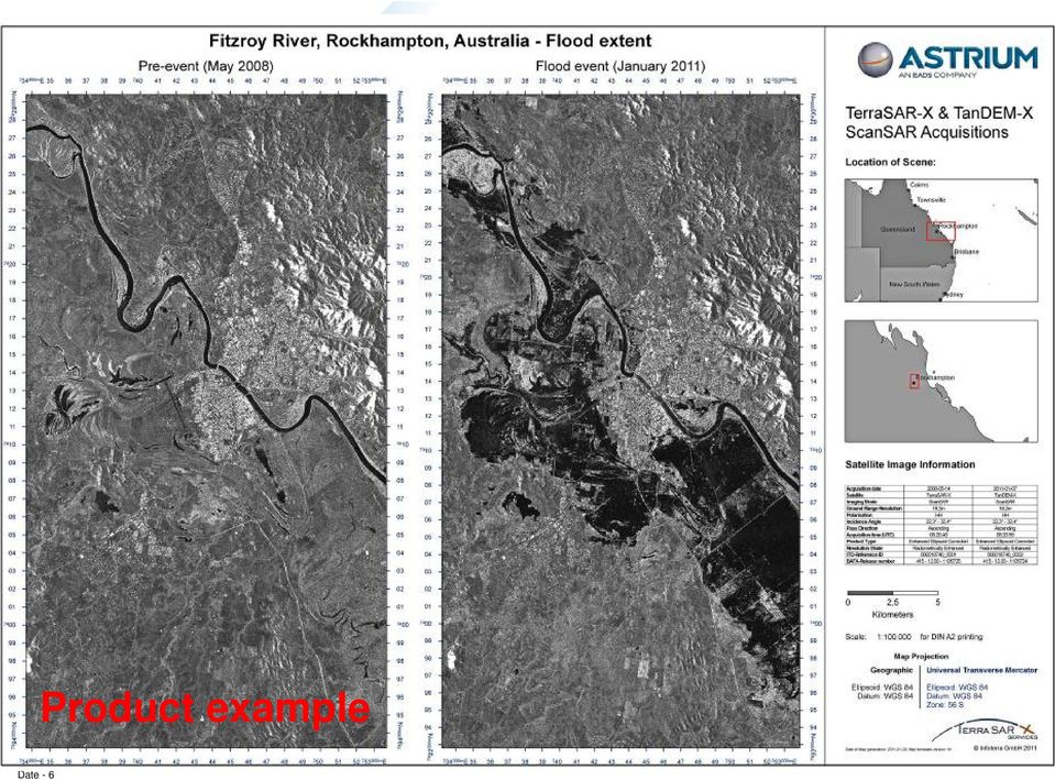
6 Date - 6 Product example
7 Date - 7 Product example

8 Date - 8 Product Specifications Flood Mask vs. Water Mask

9 Product Specifications / Input Data Water Mask Flood Mask Input data Temporal resolution Mono-temporal Bi-temporal Sensor TerraSAR-X (or TanDEM-X) Product Orbit Rapid (1-3 day delivery time, +/- 0.2m possible location error) EEC-RE Rapid Predicted (0-12 h data delivery time, +/- 700m possible location error) [Near Real Time delivery option] Mode SL, SM, SC Ancillary data SRTM DEM or other SRTM DEM or other Reference data Permanent water body shape (optional) Date - 9

10 Product Specifications / Output Data Water Mask Flood Mask Resolution Temporal Bi- Mono- Geometric Depending on TerraSAR-X imaging mode Up to 1m (Spotlight), up to 3m (StripMap) up to 18m (ScanSAR) MMU Depending on TerraSAR-X imaging mode 0,1ha (SpotLight) 0,25ha (StripMap) 5ha (ScanSAR) MMW 40 m Delivery Content/format TerraSAR-X data (if requested) tif, img Flood Mask as vector file shp Map Tif, pdf Date - 10
 tif, img Flood Mask as vector file shp Map Tif,")
11 Methodology - Description Semi-automatic generation of mono- or bitemporal water mask vector data sets by means of combination of object- and pixel-based classifications with subsequent automated change detection process in the case of bi-temporal water masks Final visual improvement of classification result close the workflow Date - 11

12 Methodology Workflow (1/2) Pre-event data (TS-X archive, multi-mission) Post-event data (TS-X) Segmentation Semi-automated Classification Water detection Semi-automated Classification Water detection Automated refinement Final water masks extraction Date - 12 Regular water extent Flood extent

13 Methodology Workflow (2/2) Calculation of segmentation parameters and segmentation: Automated procedure MMU Smoothness Automated refinements: Minimum Mapping Unit filter Smoothness of boundaries Classified scene Library workflow with user interaction QA no Manual editing yes User set value Export FLOOD SHAPE Date - 13

14 Summary Flood mapping service is based on and optimised for the use of TerraSAR-X data Service addresses pre- (permanent water) and postevent (flood) situations as well as monitoring purposes (e.g. in case of flood events over a longer period of time) Delivery of flood extent maps is possible within 48 hours after data acquisition Product delivery is according to general standards or customizable to specific requirements Date - 14
 Delivery of flood extent maps is possible within 48")
15 Thank you for your attention! Dr Marc Mueller Project Manager Risk & Crisis Service GMES & European Institutions BA4 Product Manager Disaster Management (acting) Product Management BA3 Development Line Coordination Disaster Management Development & Engineering BA3 Date - 15

16 Date - 16 Product example

17 Date - 17 Product example

TerraSAR-X Applications Guide
 TerraSAR-X Applications Guide Extract: Maritime Monitoring: Oil Spill Detection April 2015 Airbus Defence and Space Geo-Intelligence Programme Line Maritime Monitoring: Oil Spill Detection Issue As the
Operational Space- Based Crop Mapping Protocols at AAFC A. Davidson, H. McNairn and T. Fisette.
 Operational Space- Based Crop Mapping Protocols at AAFC A. Davidson, H. McNairn and T. Fisette. Science & Technology Branch. Agriculture and Agri-Food Canada. 1. Introduction Space-Based Crop Mapping at
German Earth Observation Systems and Programs Capacities for nation building
 German Earth Observation Systems and Programs Capacities for nation building German Aerospace Center, DLR, Earth Observation Center, EOC German Remote Sensing Data Center, DFD Gunter Schreier Deputy Director
Current Status and Considerations for the Future. Harald Mehl & Stefan Voigt German Aerospace Center (DLR)
") Current Status and Considerations for the Future Harald Mehl & Stefan Voigt German Aerospace Center (DLR) Supporting DLR s engagement in EO for civil security Contribution to the implementation of the
Current Status and Considerations for the Future Harald Mehl & Stefan Voigt German Aerospace Center (DLR) Supporting DLR s engagement in EO for civil security Contribution to the implementation of the
How To Write A Call To Action For Terrasar-X
 Doc.: TX-PGS-PL-4127 TerraSAR-X Announcement of Opportunity: Utilization of the TerraSAR-X Archive 1 Page: 2 of 11 TABLE OF CONTENTS TERRASAR-X... 1 ANNOUNCEMENT OF OPPORTUNITY: UTILIZATION OF THE TERRASAR-X
3D Model of the City Using LiDAR and Visualization of Flood in Three-Dimension
 3D Model of the City Using LiDAR and Visualization of Flood in Three-Dimension R.Queen Suraajini, Department of Civil Engineering, College of Engineering Guindy, Anna University, India, [email protected]
ROSA ESA - DLR Course 2009 RADAR REMOTE SENSING Day 4-5
 ROSA ESA - DLR Course 2009 RADAR REMOTE SENSING Day 4-5 Dr. Jan-Peter Mund, André Twele & Sandro Martinis German Remote Sensing Data Center (DFD) German Aerospace Center (DLR) RADAR REMOTE SENSING Introduction
The needs on big data management for Operational Geo-Info Services: Emergency Response, Maritime surveillance, Agriculture Management
 Copernicus Big-Data Workshop 2014, 13/14 March The needs on big data management for Operational Geo-Info Services: Emergency Response, Maritime surveillance, Agriculture Management Marco Corsi e-geos 1
TerraSAR-X Image Product Guide. Basic and Enhanced Radar Satellite Imagery. Airbus Defence and Space Geo-Intelligence Programme Line
 TerraSAR-X Image Product Guide Geo-Intelligence Programme Line 1 Introduction TerraSAR-X and TanDEM-X are commercial German Synthetic Aperture Radar (SAR) Earth observation satellites, which were launched
Raster to Vector Conversion for Overlay Analysis
 Raster to Vector Conversion for Overlay Analysis In some cases, it may be necessary to perform vector-based analyses on a raster data set, or vice versa. The types of analyses that can be performed on
LEOworks - a freeware to teach Remote Sensing in Schools
 LEOworks - a freeware to teach Remote Sensing in Schools Wolfgang Sulzer Institute for Geography and Regional Science University of Graz Heinrichstrasse 36, A-8010 Graz/Austria [email protected]
Adaptation of High Resolution Ikonos Images to Googleearth for Zonguldak Test Field
 Adaptation of High Resolution Ikonos Images to Googleearth for Zonguldak Test Field Umut G. SEFERCIK, Murat ORUC and Mehmet ALKAN, Turkey Key words: Image Processing, Information Content, Image Understanding,
SARscape 4.3 Supported Sensors/Products (March 2011) - Spaceborne Sensors -
 - Spaceborne Sensors -") SARscape 4.3 Supported Sensors/Products (March 2011) - Spaceborne Sensors - ALOS PALSAR (provided by JAXA) In case of RAW (level 1.0) data, import is carried out within the Focusing Module. PALSAR RAW
SARscape 4.3 Supported Sensors/Products (March 2011) - Spaceborne Sensors - ALOS PALSAR (provided by JAXA) In case of RAW (level 1.0) data, import is carried out within the Focusing Module. PALSAR RAW
Data Processing Developments at DFD/DLR. Stefanie Holzwarth Martin Bachmann, Rudolf Richter, Martin Habermeyer, Derek Rogge
 Data Processing Developments at DFD/DLR Stefanie Holzwarth Martin Bachmann, Rudolf Richter, Martin Habermeyer, Derek Rogge EUFAR Joint Expert Working Group Meeting Edinburgh, April 14th 2011 Conclusions
Aneeqa Syed [Hatfield Consultants] Vancouver GIS Users Group Meeting December 8, 2010
![Aneeqa Syed [Hatfield Consultants] Vancouver GIS Users Group Meeting December 8, 2010](/thumbs/27/11179985.jpg "Aneeqa Syed [Hatfield Consultants] Vancouver GIS Users Group Meeting December 8, 2010") NEAR-REAL-TIME FLOOD MAPPING AND MONITORING SERVICE Aneeqa Syed [Hatfield Consultants] Vancouver GIS Users Group Meeting December 8, 2010 SLIDE 1 MRC Flood Service Project Partners and Client Hatfield
NEAR-REAL-TIME FLOOD MAPPING AND MONITORING SERVICE Aneeqa Syed [Hatfield Consultants] Vancouver GIS Users Group Meeting December 8, 2010 SLIDE 1 MRC Flood Service Project Partners and Client Hatfield
High Resolution 3D Earth Observation Data Analysis for Safeguards Activities
 High Resolution 3D Earth Observation Data Analysis for Safeguards Activities Pablo d'angelo a1, Cristian Rossi a, Christian Minet a, Michael Eineder a, Michael Flory b, Irmgard Niemeyer c a German Aerospace
Imagery. 1:50,000 Basemap Generation From Satellite. 1 Introduction. 2 Input Data
 1:50,000 Basemap Generation From Satellite Imagery Lisbeth Heuse, Product Engineer, Image Applications Dave Hawkins, Product Manager, Image Applications MacDonald Dettwiler, 3751 Shell Road, Richmond B.C.
Comparison of ALOS-PALSAR and TerraSAR-X Data in terms of Detecting Settlements First Results
 ALOS 2008 Symposium, 3-7 November Rhodes, Greece Comparison of ALOS-PALSAR and TerraSAR-X Data in terms of Detecting Settlements First Results Thomas Esch*, Achim Roth*, Michael Thiel, Michael Schmidt*,
Digital Remote Sensing Data Processing Digital Remote Sensing Data Processing and Analysis: An Introduction and Analysis: An Introduction
 Digital Remote Sensing Data Processing Digital Remote Sensing Data Processing and Analysis: An Introduction and Analysis: An Introduction Content Remote sensing data Spatial, spectral, radiometric and
TerraSAR-X capabilities and constrains for acquisitions over the polar regions. Dana Floricioiu
 TerraSAR-X capabilities and constrains for acquisitions over the polar regions Dana Floricioiu STG IPY SAR Workshop Montreal 5/6 March 2008 TerraSAR-X Features Multi-Mode Imaging StripMap (High-Resolution)
Environmental Remote Sensing GEOG 2021
 Environmental Remote Sensing GEOG 2021 Lecture 4 Image classification 2 Purpose categorising data data abstraction / simplification data interpretation mapping for land cover mapping use land cover class
Structural Health Monitoring Tools (SHMTools)
") Structural Health Monitoring Tools (SHMTools) Parameter Specifications LANL/UCSD Engineering Institute LA-CC-14-046 c Copyright 2014, Los Alamos National Security, LLC All rights reserved. May 30, 2014
Structural Health Monitoring Tools (SHMTools) Parameter Specifications LANL/UCSD Engineering Institute LA-CC-14-046 c Copyright 2014, Los Alamos National Security, LLC All rights reserved. May 30, 2014
Data and Information Management for EO Data Centers. Eberhard Mikusch German Aerospace Center - German Remote Sensing Data Center
 Data and Information Management for EO Data Centers Eberhard Mikusch German Aerospace Center - Mexico, 23. 04 2008 Earth Observation System Environment at DLR/DFD 10010 00101 Radar 10010 00101 Atmospheric
TerraSAR-X Interferometry. Michael Eineder, Nico Adam Remote Sensing Technology Institute
 TerraSAR-X Interferometry Michael Eineder, Nico Adam Remote Sensing Technology Institute TerraSAR-X Contribution to Commissioning Phase: verify phase and geometric stability of instrument and SAR processor
How To Use Inspire For Eo Data Processing
 INSPIREd computing for EO Based Services Paolo MANUNTA 1, Giulio CERIOLA 1, Jens STUTTE 1 1 Planetek Italia s.r.l Via Massaua 12 I-70132 Bari E-Mail: [email protected] Workshop Big Data Roma, 26/11/2013
Monitoring a Changing Environment with Synthetic Aperture Radar. Alaska Satellite Facility National Park Service Don Atwood
 Monitoring a Changing Environment with Synthetic Aperture Radar Don Atwood Alaska Satellite Facility 1 Entering the SAR Age 2 SAR Satellites RADARSAT-1 Launched 1995 by CSA 5.6 cm (C-Band) HH Polarization
A PHOTOGRAMMETRIC APPRAOCH FOR AUTOMATIC TRAFFIC ASSESSMENT USING CONVENTIONAL CCTV CAMERA
 A PHOTOGRAMMETRIC APPRAOCH FOR AUTOMATIC TRAFFIC ASSESSMENT USING CONVENTIONAL CCTV CAMERA N. Zarrinpanjeh a, F. Dadrassjavan b, H. Fattahi c * a Islamic Azad University of Qazvin - [email protected]
Big Data Analytics for Detailed Urban Mapping. Mihai Datcu Daniela Molina Espinoza, Octavian Dumitru, Gottfried Schwarz
 Big Data Analytics for Detailed Urban Mapping Mihai Datcu Daniela Molina Espinoza, Octavian Dumitru, Gottfried Schwarz Big Data: The German EO Digital Library The data access Folie 2 Information vs. Data
Near Real Time Flood Mapping & Monitoring
 Near Real Time Flood Mapping & Monitoring C.M.BHATT Disaster Management Support Division National Remote Sensing Centre (NRSC / ISRO) Hyderabad, India [email protected] 7-8 December, 2014 ISPRS PRE-SYMPOSIUM
The RapidEye optical satellite family for high resolution imagery
 'Photogrammetric Week 01' D. Fritsch & R. Spiller, Eds. Wichmann Verlag, Heidelberg 2001. Scherer, Krischke 139 The RapidEye optical satellite family for high resolution imagery STEFAN SCHERER and MANFRED
The DLR Multi Mission EO Ground Segment
 The DLR Multi Mission EO Ground Segment Payload Ground Segment Erhard Diedrich Remote Sensing Workshop Mexico 22-24 April 2008 DLR Ground Segment for Earth Observation: Servicing GMES, national and commercial
EO Information Services in support of Satellite Tools for Building Flood Defence Systems in Guyana
 EO Information Services in support of Satellite Tools for Building Flood Defence Systems in Guyana F. N. Koudogbo and A. Arnaud Altamira Information I. Bauwens, H. Tambuyzer Eurosense Date : 21 February
Cluster Applied Remote Sensing TerraSAR-X Ground Segment Basic Product Specification Document. Ground Segment. Basic Product Specif ication Document
 Page: 1 of 108 Ground Segment Basic Product Specif ication Document CAF - Cluster Applied Remote Sensing editors: 30.3.2009 T. Fritz, M. Eineder Date SAR ~rbduct Verification Responsible & TMSP Team reviewed:
PI: Riccardo Lanari (IREA CNR) email:[email protected]
 email:lanari.r@irea.cnr.it") On the exploitation and validation of COSMO-SkyMed interferometric SAR data for digital terrain modelling and surface deformation analysis in extensive urban areas (ID: 1441) Project partners: Istituto
On the exploitation and validation of COSMO-SkyMed interferometric SAR data for digital terrain modelling and surface deformation analysis in extensive urban areas (ID: 1441) Project partners: Istituto
Machine Learning: Overview
 Machine Learning: Overview Why Learning? Learning is a core of property of being intelligent. Hence Machine learning is a core subarea of Artificial Intelligence. There is a need for programs to behave
Improve your equity research productivity
 Improve your equity research productivity Creating and updating company models Standardized Excel based company models ensure each analyst s work seamlessly integrates with research database and can be
The following was presented at DMT 14 (June 1-4, 2014, Newark, DE).
.") DMT 2014 The following was presented at DMT 14 (June 1-4, 2014, Newark, DE). The contents are provisional and will be superseded by a paper in the DMT 14 Proceedings. See also presentations and Proceedings
DMT 2014 The following was presented at DMT 14 (June 1-4, 2014, Newark, DE). The contents are provisional and will be superseded by a paper in the DMT 14 Proceedings. See also presentations and Proceedings
COMPARISON OF OBJECT BASED AND PIXEL BASED CLASSIFICATION OF HIGH RESOLUTION SATELLITE IMAGES USING ARTIFICIAL NEURAL NETWORKS
 COMPARISON OF OBJECT BASED AND PIXEL BASED CLASSIFICATION OF HIGH RESOLUTION SATELLITE IMAGES USING ARTIFICIAL NEURAL NETWORKS B.K. Mohan and S. N. Ladha Centre for Studies in Resources Engineering IIT
Real Time Services for Space Applications Holger Maass, Susanne Lehner
 Real Time Services for Space Applications Holger Maass, Susanne Lehner [email protected] German Remote Sensing Data Center ( DFD ) with 2 locations in Germany Neustrelitz in Mecklenburg-Vorpommern Oberpfaffenhofen
Reading Questions. Lo and Yeung, 2007: 2 19. Schuurman, 2004: Chapter 1. 1. What distinguishes data from information? How are data represented?
 Reading Questions Week two Lo and Yeung, 2007: 2 19. Schuurman, 2004: Chapter 1. 1. What distinguishes data from information? How are data represented? 2. What sort of problems are GIS designed to solve?
POTENTIALS OF HIGH RESOLUTION TERRASAR-X IMAGES IN INSAR PROCESSING
 POTENTIALS OF HIGH RESOLUTION TERRASAR-X IMAGES IN INSAR PROCESSING FOR EARTH DEFORMATION AND ENVIRONMENTAL STUDIES Magdalena Niemiec 1 Abstract Accurate determination of topography and surface deformation
TerraAmazon - The Amazon Deforestation Monitoring System - Karine Reis Ferreira
 TerraAmazon - The Amazon Deforestation Monitoring System - Karine Reis Ferreira GEOSS Users & Architecture Workshop XXIV: Water Security & Governance - Accra Ghana / October 2008 INPE National Institute
Information Contents of High Resolution Satellite Images
 Information Contents of High Resolution Satellite Images H. Topan, G. Büyüksalih Zonguldak Karelmas University K. Jacobsen University of Hannover, Germany Keywords: satellite images, mapping, resolution,
FreeForm Designer. Phone: +972-9-8309999 Fax: +972-9-8309998 POB 8792, Natanya, 42505 Israel www.autofont.com. Document2
 FreeForm Designer FreeForm Designer enables designing smart forms based on industry-standard MS Word editing features. FreeForm Designer does not require any knowledge of or training in programming languages
GEOSPATIAL DIGITAL ASSET MANAGEMENT A SOLUTION INTEGRATING IMAGERY AND GIS WHERE WILL ALL THE PIXELS GO?(AND HOW WILL WE EVER FIND THEM?
 GEOSPATIAL DIGITAL ASSET MANAGEMENT A SOLUTION INTEGRATING IMAGERY AND GIS WHERE WILL ALL THE PIXELS GO?(AND HOW WILL WE EVER FIND THEM?) Dr. Joan Lurie, GCC, Inc. 30 West 61 st Street, Apt 9A New York,
Satellites for Terrain Motion Mapping Terrafirma User Workshop Mining. Nico Adam
 Satellites for Terrain Motion Mapping Terrafirma User Workshop Mining Nico Adam Outline SAR / InSAR observation characteristic Sensors TSX, TDX ERS-1, ERS-2 Processing techniques D-InSAR PSI SBAS Acquisition
Land Use/ Land Cover Mapping Initiative for Kansas and the Kansas River Watershed
 Land Use/ Land Cover Mapping Initiative for Kansas and the Kansas River Watershed Kansas Biological Survey Kansas Applied Remote Sensing Program April 2008 Previous Kansas LULC Projects Kansas LULC Map
Infoterra TanDEM-X Science Meeting Commercial Exploitation
 Infoterra TanDEM-X Science Meeting Commercial Exploitation Bernd Scheuchl & Jürgen Janoth 24.11.2008 Contents Introduction of Infoterra Commercial Exploitation Strategy Final DEM Customized HRTI-4 DEMs
ENVI THE PREMIER SOFTWARE FOR EXTRACTING INFORMATION FROM GEOSPATIAL IMAGERY.
 ENVI THE PREMIER SOFTWARE FOR EXTRACTING INFORMATION FROM GEOSPATIAL IMAGERY. ENVI Imagery Becomes Knowledge ENVI software uses proven scientific methods and automated processes to help you turn geospatial
VCS REDD Methodology Module. Methods for monitoring forest cover changes in REDD project activities
 1 VCS REDD Methodology Module Methods for monitoring forest cover changes in REDD project activities Version 1.0 May 2009 I. SCOPE, APPLICABILITY, DATA REQUIREMENT AND OUTPUT PARAMETERS Scope This module
DEM products from TerraSAR-X & TanDEM-X. Nora Meyer zu Erpen // 25.01.2011
 DEM products from TerraSAR- & TanDEM- Nora Meyer zu Erpen // 25.01.2011 GEO-Information Services within Astrium and EADS Airbus Eurocopter Cassidian Astrium Turnover 2009: 4.8 billion Staff 2009: 15,000*
DEVELOPMENT OF A SUPERVISED SOFTWARE TOOL FOR AUTOMATED DETERMINATION OF OPTIMAL SEGMENTATION PARAMETERS FOR ECOGNITION
 DEVELOPMENT OF A SUPERVISED SOFTWARE TOOL FOR AUTOMATED DETERMINATION OF OPTIMAL SEGMENTATION PARAMETERS FOR ECOGNITION Y. Zhang* a, T. Maxwell, H. Tong, V. Dey a University of New Brunswick, Geodesy &
New Features in TerraPhoto. Arttu Soininen Software developer Terrasolid Ltd
 New Features in TerraPhoto Arttu Soininen Software developer Terrasolid Ltd Export City Model Improvements Roof slope setting determines what polygons will be treated as walls and what as roofs Write roofs
Information Technology Systems (2012)
") Information Technology Systems (2012) Sample work program April 2012 Information Technology Systems (2012) Sample work program Compiled by the Queensland Studies Authority April 2012 This work program
Information Technology Systems (2012) Sample work program April 2012 Information Technology Systems (2012) Sample work program Compiled by the Queensland Studies Authority April 2012 This work program
Blender addons ESRI Shapefile import/export and georeferenced raster import
 Blender addons ESRI Shapefile import/export and georeferenced raster import This blender addon is a collection of 4 tools: ESRI Shapefile importer - Import point, pointz, polyline, polylinez, polygon,
Mapping Solar Energy Potential Through LiDAR Feature Extraction
 Mapping Solar Energy Potential Through LiDAR Feature Extraction WOOLPERT WHITE PAPER By Brad Adams [email protected] DESIGN GEOSPATIAL INFRASTRUCTURE November 2012 Solar Energy Potential Is Largely
OCAD smart for cartography A niche product towards a professional cartographic. software
 OCAD 10 OCAD smart for cartography A niche product towards a professional cartographic software Positioning of OCAD Geodata Mobile Data Entry (GPS) Internet Desktop Publishing (DTP) OCAD Import and Export
ENVI Services Engine: Scientific Data Analysis and Image Processing for the Cloud
 ENVI Services Engine: Scientific Data Analysis and Image Processing for the Cloud Bill Okubo, Greg Terrie, Amanda O Connor, Patrick Collins, Kevin Lausten The information contained in this document pertains
REGIONAL CENTRE FOR TRAINING IN AEROSPACE SURVEYS (RECTAS) MASTER IN GEOINFORMATION PRODUCTION AND MANAGEMENT
 MASTER IN GEOINFORMATION PRODUCTION AND MANAGEMENT") REGIONAL CENTRE FOR TRAINING IN AEROSPACE SURVEYS (RECTAS) MASTER IN GEOINFORMATION PRODUCTION AND MANAGEMENT PROGRAMME DESCRIPTION October 2014 1. The programme The academic programme shall be referred
REGIONAL CENTRE FOR TRAINING IN AEROSPACE SURVEYS (RECTAS) MASTER IN GEOINFORMATION PRODUCTION AND MANAGEMENT PROGRAMME DESCRIPTION October 2014 1. The programme The academic programme shall be referred
A GIS helps you answer questions and solve problems by looking at your data in a way that is quickly understood and easily shared.
 A Geographic Information System (GIS) integrates hardware, software, and data for capturing, managing, analyzing, and displaying all forms of geographically referenced information. GIS allows us to view,
Introduction to Computer Graphics
 Introduction to Computer Graphics Torsten Möller TASC 8021 778-782-2215 [email protected] www.cs.sfu.ca/~torsten Today What is computer graphics? Contents of this course Syllabus Overview of course topics
Cartographic and Geospatial Materials
 LIBRARY OF CONGRESS COLLECTIONS POLICY STATEMENTS ±² Collections Policy Statement Index Cartographic and Geospatial Materials This document consolidates and replaces the former Maps, Atlases, and Remote
Supervised Classification workflow in ENVI 4.8 using WorldView-2 imagery
 Supervised Classification workflow in ENVI 4.8 using WorldView-2 imagery WorldView-2 is the first commercial high-resolution satellite to provide eight spectral sensors in the visible to near-infrared
Adobe Certified Expert Program
 Adobe Certified Expert Program Product Proficiency Exam Bulletin Adobe Photoshop CS4 Exam # 9A0-094 ACE Certification Checklist The checklist below will help guide you through the process of obtaining
Map World Forum Hyderabad, India Introduction: High and very high resolution space images: GIS Development
 Very high resolution satellite images - competition to aerial images Dr. Karsten Jacobsen Leibniz University Hannover, Germany [email protected] Introduction: Very high resolution images taken
KIP 3000 Series MULTIFUNCTION SIMPLICITY
 KIP 3000 Series MULTIFUNCTION SIMPLICITY KIP 3000 SERIES SYSTEMS The KIP 3000 is a highly hl advanced d wide format digital copy system that provides the ability to easily add network printing and scan-to-file
Samples of Management Consulting Assignments. Performed by DCAG are. Provided in the following pages.
 Samples of Management Consulting Assignments Performed by DCAG are Provided in the following pages. Thomas Bronack 15180 20 th Avenue Whitestone, NY 11357 Phone: (718) 591-5553 Cell: (917) 673-6992 Email:
Cloud-based Geospatial Data services and analysis
 Cloud-based Geospatial Data services and analysis Xuezhi Wang Scientific Data Center Computer Network Information Center Chinese Academy of Sciences 2014-08-25 Outlines 1 Introduction of Geospatial Data
Geospatial Software Solutions for the Environment and Natural Resources
 Geospatial Software Solutions for the Environment and Natural Resources Manage and Preserve the Environment and its Natural Resources Our environment and the natural resources it provides play a growing
Advantages and limitations of using satellite images for flood mapping
 Advantages and limitations of using satellite images for flood mapping Domenico Grandoni e-geos Headquarter Contrada Terlecchie 75100 Matera - Italy Commercial Office Via Cannizzaro 71 00156 Roma - Italy
Vulnerability assessment of ecosystem services for climate change impacts and adaptation (VACCIA)
") Vulnerability assessment of ecosystem services for climate change impacts and adaptation (VACCIA) Action 2: Derivation of GMES-related remote sensing data Deliverable 1: Time-series of Earth Observation
Vulnerability assessment of ecosystem services for climate change impacts and adaptation (VACCIA) Action 2: Derivation of GMES-related remote sensing data Deliverable 1: Time-series of Earth Observation
Copyright 2005-2010 Soleran, Inc. esalestrack On-Demand CRM. Trademarks and all rights reserved. esalestrack is a Soleran product Privacy Statement

Graphic Design for Beginners
 Graphic Design for Beginners Level: Duration: Time: Cost: Introduction 6 Days 9:30 AM - 4:30 PM Call for details Overview Managing the Adobe Photoshop Environment Working with Selections Enhancing an Image
VECTORAL IMAGING THE NEW DIRECTION IN AUTOMATED OPTICAL INSPECTION
 VECTORAL IMAGING THE NEW DIRECTION IN AUTOMATED OPTICAL INSPECTION Mark J. Norris Vision Inspection Technology, LLC Haverhill, MA [email protected] ABSTRACT Traditional methods of identifying and
technical notes trimble realworks software
 technical notes trimble realworks software A POWERFUL 3D LASER SCANNING OFFICE SOFTWARE SUITE Designed for today s multifaceted scanning professional, Trimble RealWorks is a powerful office software that
UPDATING OBJECT FOR GIS DATABASE INFORMATION USING HIGH RESOLUTION SATELLITE IMAGES: A CASE STUDY ZONGULDAK
 UPDATING OBJECT FOR GIS DATABASE INFORMATION USING HIGH RESOLUTION SATELLITE IMAGES: A CASE STUDY ZONGULDAK M. Alkan 1, *, D. Arca 1, Ç. Bayik 1, A.M. Marangoz 1 1 Zonguldak Karaelmas University, Engineering
Keystone Image Management System
 Image management solutions for satellite and airborne sensors Overview The Keystone Image Management System offers solutions that archive, catalogue, process and deliver digital images from a vast number
LCCS & GeoVIS for land cover mapping. Experience Sharing of an Exercise
 LCCS & GeoVIS for land cover mapping Experience Sharing of an Exercise Forest Survey of India Subhash Ashutosh Joint Director Study Area Topographic sheet 53J4 Longitude - 78ºE - 78º15'E Latitude - 30ºN
Automatic land-cover map production of agricultural areas using supervised classification of SPOT4(Take5) and Landsat-8 image time series.
 and Landsat-8 image time series.") Automatic land-cover map production of agricultural areas using supervised classification of SPOT4(Take5) and Landsat-8 image time series. Jordi Inglada 2014/11/18 SPOT4/Take5 User Workshop 2014/11/18
Automatic land-cover map production of agricultural areas using supervised classification of SPOT4(Take5) and Landsat-8 image time series. Jordi Inglada 2014/11/18 SPOT4/Take5 User Workshop 2014/11/18
Trimble Realworks Software
 TECHNICAL NOTES Trimble Realworks Software A Powerful 3D Laser Scanning Office Software Suite DESIGNED FOR TODAY S MULTIFACETED SCANNING PROFESSIONAL, TRIMBLE REALWORKS IS A POWERFUL OFFICE SOFTWARE THAT
Introduction to GIS (Basics, Data, Analysis) & Case Studies. 13 th May 2004. Content. What is GIS?
 & Case Studies. 13 th May 2004. Content. What is GIS?") Introduction to GIS (Basics, Data, Analysis) & Case Studies 13 th May 2004 Content Introduction to GIS Data concepts Data input Analysis Applications selected examples What is GIS? Geographic Information
Introduction to GIS (Basics, Data, Analysis) & Case Studies 13 th May 2004 Content Introduction to GIS Data concepts Data input Analysis Applications selected examples What is GIS? Geographic Information
Managing Lidar (and other point cloud) Data. Lindsay Weitz Cody Benkelman
 Data. Lindsay Weitz Cody Benkelman") (and other point cloud) Data Lindsay Weitz Cody Benkelman Presentation Context What is lidar, and how does it work? Not this presentation! What can you do with lidar in ArcGIS? What does Esri recommend
(and other point cloud) Data Lindsay Weitz Cody Benkelman Presentation Context What is lidar, and how does it work? Not this presentation! What can you do with lidar in ArcGIS? What does Esri recommend
Extract from NCTech Application Notes & Case Studies Download the complete booklet from nctechimaging.com/technotes
 Extract from NCTech Application Notes & Case Studies Download the complete booklet from nctechimaging.com/technotes [Application note Blackburn Rovers, Ewood park] Trimble TX8 scan colourisation with istar
DATA QUALITY IN GIS TERMINOLGY GIS11
 DATA QUALITY IN GIS When using a GIS to analyse spatial data, there is sometimes a tendency to assume that all data, both locational and attribute, are completely accurate. This of course is never the
ARIZONA CTE CAREER PREPARATION STANDARDS & MEASUREMENT CRITERIA. Graphic/Web Design 10.0200.30
 Graphic/Web Design 10.0200.30 1.0 ANALYZE THE MEDIA INDUSTRY, ITS BUSINESS PRACTICES, AND ITS ROLE IN THE ECONOMY 1.1 Research the role of the media industry and its impact on society and the economy 1.2
An Esri White Paper August 2010 Product Library in Esri Aeronautical Solution: Enabling Seamless Product, Data, and Document Management
 An Esri White Paper August 2010 Product Library in Esri Aeronautical Solution: Enabling Seamless Product, Data, and Document Management Esri, 380 New York St., Redlands, CA 92373-8100 USA TEL 909-793-2853
An Assessment of the Effectiveness of Segmentation Methods on Classification Performance
 An Assessment of the Effectiveness of Segmentation Methods on Classification Performance Merve Yildiz 1, Taskin Kavzoglu 2, Ismail Colkesen 3, Emrehan K. Sahin Gebze Institute of Technology, Department