Big Data Challenge: Mining Heterogeneous Data. Prof. Mihai Datcu. German Aerospace Center (DLR) Munich Aerospace Faculty
|
|
|
- Harriet Della Parrish
- 10 years ago
- Views:
Transcription
1 Big Data Challenge: Mining Heterogeneous Data Prof. Mihai Datcu German Aerospace Center (DLR) Munich Aerospace Faculty
 Munich Aerospace")
2 Sensing & Big Data Big Data: - Computer hardware and the Cloud - Storage Challenges arise such as - Processing and analyzing - Sensors technologies Big Data does not mean the size Chris Eaton, Dirk Deroos, Tom Deutsch, George Lapis, and Paul Zikopoulos, Understanding Big Data.: McGraw-Hill Companies, April 2012, Folie 2 2

3 Big Data Mining Emerging applications Big Data Mining The research areas Folie 3 3

4 MULTISPECTRAL and SPATIAL & INFORMATION CONTENT WorldView 8 bands, 2 meter: spectral classes Spatial categories Folie 4 4

5 Query by Example: browsing and exploring large data sets Image query Query result Effectiveness evaluation: Precision & Recall Folie 5 5

6 TerraSAR-X, 1m resolution SAR images: HUGE DIVERSITY OF INFORMATION CONTENT Folie 6 6

7 Semantic annotation based on active learning Positive and negative examples Methodology: PF algorithm Classification SVM with RF Annotated category Semantic Patches Collections Ground truth Optimal parameters: product type (MGD), mode (High resolution Spotlight), geometric resolution configurations (RE), patch size (160 x 160 pixels); PF algorithm (Gabor filters) 7 Folie 7 7
, patch size (160 x 160 pixels); PF algorithm (Gabor filters) 7")
8 INFORMATION CONTENT EXPLORATION: Visual Analitics 1 HS TerraSAR-X Scene = up to image patches (100 x 100 m) Folie 8 8

9 Semantic catalogues 300 cities, image tiles, 850 words Folie 9 9

10 From CLC to EO semantic taxonomy Legend - categories defined for Venice using CORINE Land Cover nomenclature: Marine waters coastal lagoons Marine waters sea and ocean Urban fabric Pastures Forest Heterogeneous agricultural areas Open spaces with little or no vegetation Industrial, commercial and transport units Open spaces with little or no vegetation Artificial, non-agricultural vegetated areas Using: CLC 10 categories; our methodology 17 categories In the case of CLC some categories are mixed together (e.g., the bridges are included in marine waters coastal lagoons) Bridge Port Airport Water and boats Venice taxonomies (using TerraSAR-X data) Water and Bouy Water Agriculture Vegetation Cemetery vegetation Railway tracks Urban Water and urban Breaking waves River deposit Beach area Vegetation and buildings Folie 10 10

11 Query by Semantics TerraSAR-X data model Semantic annotation of TerraSAR-X image content queries SELECT label_id, name, FROM annotation a Join label l on a.label_id=l.label_id 11 Folie 11 11

12 Satellite Image Time Series Evolution Classes and Data Analitics Folie

13 In-situ data: LUCAS 2009/2012 Folie 13 13

14 EXOGENOUS SOURCES & EO DATA ANALITICS: LUCAS & TerraSAR-X Folie 14 14

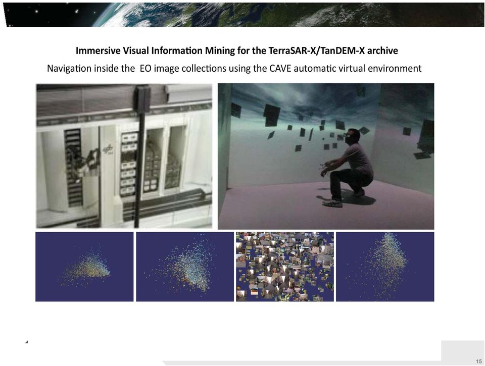
15 Folie 15 15
16 Features Volume and multimodality of data is growing Data and information is spatio-temporal and unstructured Users want to have the knowledge Interactive is the only way of operation Exploration is predominant Context is critical and relevant Users are interested in information and knowledge independent of conjecture Folie

17 Challanges Too long cycle theory - tehnology users More to work for inter-domains communication (application but also theory) More applications on real data needed Folie

18 Selected Publications 1. Blanchart, Pierre and Ferecatu, Marin and Cui, Shiyong and Datcu, Mihai (2014) Pattern retrieval in large image databases using multiscale coarse-to-fine cascaded active learning, IEEE JSTARS. (in press) 2. Cerra, Daniele and Datcu, Mihai (2013), Expanding the Algorithmic Information Theory Frame for Applications to Earth Observation. Entropy, 15 (1), pp Cui, Shiyong and Dumitru, Corneliu Octavian and Datcu, Mihai (2013), Ratio-Detector-Based Feature Extraction for Very High Resolution SAR Image Patch Indexing. IEEE Geoscience and Remote Sensing Letters, 10 (5), pp Dumitru, Octavian and Datcu, Mihai (2013), Information Content of Very High Resolution SAR Images: Study of Feature Extraction and Imaging Parameters. IEEE Transactions on Geoscience and Remote Sensing, 51 (8), pp Vaduva, Corina and Gavat, Inge and Datcu, Mihai (2013), Latent Dirichlet Allocation for Spatial Analysis of Satellite Images. IEEE Transactions on Geoscience and Remote Sensing, 51 (5), pp Vaduva, Corina and Costachioiu, Teodor and Patrascu, Carmen and Gavat, Inge and Lazarescu, Vasile and Datcu, Mihai (2013), A Latent Analysis of Earth Surface Dynamic Evolution Using Change Map Time Series. IEEE Transactions on Geoscience and Remote Sensing, 51 (4), pp Venganzones, Miguel and Datcu, Mihai and Graa, Manuel (2013), Further results on dissimilarity spaces for hyperspectral images RF-CBIR. Pattern Recognition Letters, 34 (14), pp Folie 18 18
, Ratio-Detector-Based Feature Extraction for Very High Resolution SAR Image Patch Indexing.")
19 Publications (journals) 9. Dumitru, Corneliu Octavian and Datcu, Mihai (2013), Information Content of Very High Resolution SAR Images: Semantics, Geospatial Context, and Ontologies. JSTARS, (submitted) 10. Espinoza-Molina, Daniela and Datcu, Mihai (2013), Earth-Observation Image Retrieval Based on Content, Semantics, and Metadata. IEEE Transactions on Geoscience and Remote Sensing, Early Access, pp Singh, Jagmal and Datcu, Mihai (2013), SAR Image Categorization With Log Cumulants of the Fractional Fourier Transform Coefficients. IEEE Transactions on Geoscience and Remote Sensing, Early Access, pp Singh, Jagmal and Espinoza-Molina, Daniela and Datcu, Mihai (2013), Evaluation of Gibbs Random Fields-based and Wavelet-based Methods for Primitive Feature Extraction in Metric-Resolution SAR Images. JSTARS, (submitted) 13. Vaduva, Corina and Gavat, Inge and Datcu, Mihai (2013), Latent Dirichlet Allocation for Spatial Analysis of Satellite Images. IEEE Transactions on Geoscience and Remote Sensing, 51 (5), pp Vaduva, Corina and Costachioiu, Teodor and Patrascu, Carmen and Gavat, Inge and Lazarescu, Vasile and Datcu, Mihai (2013), A Latent Analysis of Earth Surface Dynamic Evolution Using Change Map Time Series. IEEE Transactions on Geoscience and Remote Sensing, 51 (4), pp Venganzones, Miguel and Datcu, Mihai and Graa, Manuel (2013), Further results on dissimilarity spaces for hyperspectral images RF-CBIR. Pattern Recognition Letters, 34 (14), pp And ca. 30 conference proceedings articles 19 Folie 19 19
, SAR Image Categorization With Log Cumulants of the Fractional Fourier Transform Coefficients.")
20 Collaboration with CNES and ParisTech Collaboration with University Politehnica Bucharest A Virtual Observatory for TerraSAR-X Data (FP7 ICT) Earth Observation Image Librarian (ESA GSTP) Folie 20 20
 Earth Observation Image Librarian")
21 The 9 th ESA-SatCen-JRC Image Information Mining Conference: the Sentinels Era 5-7 March, 2014 Romanian Space Agency Bucharest, Romania Folie 21 21
22 12-14 November 2014 ESA-ESRIN Frascati, Italy Call for papers and participation Folie 22 22
Big Data Analytics for Detailed Urban Mapping. Mihai Datcu Daniela Molina Espinoza, Octavian Dumitru, Gottfried Schwarz
 Big Data Analytics for Detailed Urban Mapping Mihai Datcu Daniela Molina Espinoza, Octavian Dumitru, Gottfried Schwarz Big Data: The German EO Digital Library The data access Folie 2 Information vs. Data
Modelling, Extraction and Description of Intrinsic Cues of High Resolution Satellite Images: Independent Component Analysis based approaches
 Modelling, Extraction and Description of Intrinsic Cues of High Resolution Satellite Images: Independent Component Analysis based approaches PhD Thesis by Payam Birjandi Director: Prof. Mihai Datcu Problematic
SEMANTIC CLASSIFICATION OF VERY HIGH RESOLUTION EARTH OBSERVATION IMAGE CONTENT BASED ON TOPOLOGICAL INFORMATION
 U.P.B. Sci. Bull., Series C, Vol. 74, Iss. 3, 2012. ISSN 1454-234x SEMANTIC CLASSIFICATION OF VERY HIGH RESOLUTION EARTH OBSERVATION IMAGE CONTENT BASED ON TOPOLOGICAL INFORMATION Corina VĂDUVA 1, Inge
Research On The Classification Of High Resolution Image Based On Object-oriented And Class Rule
 Research On The Classification Of High Resolution Image Based On Object-oriented And Class Rule Li Chaokui a,b, Fang Wen a,b, Dong Xiaojiao a,b a National-Local Joint Engineering Laboratory of Geo-Spatial
CLASSIFICATION ACCURACY INCREASE USING MULTISENSOR DATA FUSION
 CLASSIFICATION ACCURACY INCREASE USING MULTISENSOR DATA FUSION Aliaksei Makarau, Gintautas Palubinskas, and Peter Reinartz German Aerospace Center (DLR) German Remote Sensing Data Center (DFD) bzw. Remote
IEEE JOURNAL OF SELECTED TOPICS IN APPLIED EARTH OBSERVATIONS AND REMOTE SENSING 1
 IEEE JOURNAL OF SELECTED TOPICS IN APPLIED EARTH OBSERVATIONS AND REMOTE SENSING 1 Very-High-Resolution SAR Images and Linked Open Data Analytics Based on Ontologies Daniela Espinoza-Molina, Member, IEEE,
An Assessment of the Effectiveness of Segmentation Methods on Classification Performance
 An Assessment of the Effectiveness of Segmentation Methods on Classification Performance Merve Yildiz 1, Taskin Kavzoglu 2, Ismail Colkesen 3, Emrehan K. Sahin Gebze Institute of Technology, Department
Big data and Earth observation New challenges in remote sensing images interpretation
 Big data and Earth observation New challenges in remote sensing images interpretation Pierre Gançarski ICube CNRS - Université de Strasbourg 2014 Pierre Gançarski Big data and Earth observation 1/58 1
How To Use Data From Copernicus And Big Data To Help The Environment
 Copernicus and Big Data: Challenges and Opportunities Alessandro Annoni European Commission Joint Research Centre www.jrc.ec.europa.eu Serving society Stimulating innovation Supporting legislation Big
Prediction of Storm Surge using Space Data. Susanne Lehner German Aerospace Center
 Prediction of Storm Surge using Space Data Susanne Lehner German Aerospace Center Existing Crisis Information State of the Art of Satellite Crisis Information (ZKI) Mapping after the storm www.zki.de
monitoring in Romania
 Satellite based service for flood monitoring in Romania Gheorghe Stancalie 1, Vasile Craciunescu 1 Ion Nedelcu 2, Anisoara Irimescu 1 1 National Meteorological Administration 2 Romanian Space Agency Floods
Silviu Panica, Marian Neagul, Daniela Zaharie and Dana Petcu (Romania)
") Silviu Panica, Marian Neagul, Daniela Zaharie and Dana Petcu (Romania) Outline Introduction EO challenges; EO and classical/cloud computing; EO Services The computing platform Cluster -> Grid -> Cloud
Silviu Panica, Marian Neagul, Daniela Zaharie and Dana Petcu (Romania) Outline Introduction EO challenges; EO and classical/cloud computing; EO Services The computing platform Cluster -> Grid -> Cloud
SAMPLE MIDTERM QUESTIONS
 Geography 309 Sample MidTerm Questions Page 1 SAMPLE MIDTERM QUESTIONS Textbook Questions Chapter 1 Questions 4, 5, 6, Chapter 2 Questions 4, 7, 10 Chapter 4 Questions 8, 9 Chapter 10 Questions 1, 4, 7
German Earth Observation Systems and Programs Capacities for nation building
 German Earth Observation Systems and Programs Capacities for nation building German Aerospace Center, DLR, Earth Observation Center, EOC German Remote Sensing Data Center, DFD Gunter Schreier Deputy Director
Hyperspectral Satellite Imaging Planning a Mission
 Hyperspectral Satellite Imaging Planning a Mission Victor Gardner University of Maryland 2007 AIAA Region 1 Mid-Atlantic Student Conference National Institute of Aerospace, Langley, VA Outline Objective
WATER BODY EXTRACTION FROM MULTI SPECTRAL IMAGE BY SPECTRAL PATTERN ANALYSIS
 WATER BODY EXTRACTION FROM MULTI SPECTRAL IMAGE BY SPECTRAL PATTERN ANALYSIS Nguyen Dinh Duong Department of Environmental Information Study and Analysis, Institute of Geography, 18 Hoang Quoc Viet Rd.,
An Automatic and Accurate Segmentation for High Resolution Satellite Image S.Saumya 1, D.V.Jiji Thanka Ligoshia 2
 An Automatic and Accurate Segmentation for High Resolution Satellite Image S.Saumya 1, D.V.Jiji Thanka Ligoshia 2 Assistant Professor, Dept of ECE, Bethlahem Institute of Engineering, Karungal, Tamilnadu,
Review for Introduction to Remote Sensing: Science Concepts and Technology
 Review for Introduction to Remote Sensing: Science Concepts and Technology Ann Johnson Associate Director [email protected] Funded by National Science Foundation Advanced Technological Education program [DUE
'Developments and benefits of hydrographic surveying using multispectral imagery in the coastal zone
 Abstract With the recent launch of enhanced high-resolution commercial satellites, available imagery has improved from four-bands to eight-band multispectral. Simultaneously developments in remote sensing
ABSTRACT INTRODUCTION PURPOSE
 EVALUATION OF TSUNAMI DISASTER BY THE 2011 OFF THE PACIFIC COAST OF TOHOKU EARTHQUAKE IN JAPAN BY USING TIME SERIES SATELLITE IMAGES WITH MULTI RESOLUTION Hideki Hashiba Associate Professor Department
CROP CLASSIFICATION WITH HYPERSPECTRAL DATA OF THE HYMAP SENSOR USING DIFFERENT FEATURE EXTRACTION TECHNIQUES
 Proceedings of the 2 nd Workshop of the EARSeL SIG on Land Use and Land Cover CROP CLASSIFICATION WITH HYPERSPECTRAL DATA OF THE HYMAP SENSOR USING DIFFERENT FEATURE EXTRACTION TECHNIQUES Sebastian Mader
Pixel-based and object-oriented change detection analysis using high-resolution imagery
 Pixel-based and object-oriented change detection analysis using high-resolution imagery Institute for Mine-Surveying and Geodesy TU Bergakademie Freiberg D-09599 Freiberg, Germany [email protected]
Methods for Monitoring Forest and Land Cover Changes and Unchanged Areas from Long Time Series
 Methods for Monitoring Forest and Land Cover Changes and Unchanged Areas from Long Time Series Project using historical satellite data from SACCESS (Swedish National Satellite Data Archive) for developing
Satellite and ground-based remote sensing for rapid seismic vulnerability assessment M. Wieland, M. Pittore
 Satellite and ground-based remote sensing for rapid seismic vulnerability assessment M. Wieland, M. Pittore Helmholtz Centre Potsdam GFZ German Research Centre for Geosciences Centre for Early Warning
ROSA ESA - DLR Course 2009 RADAR REMOTE SENSING Day 4-5
 ROSA ESA - DLR Course 2009 RADAR REMOTE SENSING Day 4-5 Dr. Jan-Peter Mund, André Twele & Sandro Martinis German Remote Sensing Data Center (DFD) German Aerospace Center (DLR) RADAR REMOTE SENSING Introduction
Satellites for Terrain Motion Mapping Terrafirma User Workshop Mining. Nico Adam
 Satellites for Terrain Motion Mapping Terrafirma User Workshop Mining Nico Adam Outline SAR / InSAR observation characteristic Sensors TSX, TDX ERS-1, ERS-2 Processing techniques D-InSAR PSI SBAS Acquisition
Comparison of ALOS-PALSAR and TerraSAR-X Data in terms of Detecting Settlements First Results
 ALOS 2008 Symposium, 3-7 November Rhodes, Greece Comparison of ALOS-PALSAR and TerraSAR-X Data in terms of Detecting Settlements First Results Thomas Esch*, Achim Roth*, Michael Thiel, Michael Schmidt*,
Enabling Semantic Search in Geospatial Metadata Catalogue to Support Polar Sciences
 Enabling Semantic Search in Geospatial Metadata Catalogue to Support Polar Sciences Wenwen Li 1 and Vidit Bhatia 2 1 GeoDa Center for Geospatial Analysis and Computation School of Geographical Sciences
INVESTIGA I+D+i 2013/2014
 INVESTIGA I+D+i 2013/2014 SPECIFIC GUIDELINES ON AEROSPACE OBSERVATION OF EARTH Text by D. Eduardo de Miguel October, 2013 Introducction Earth observation is the use of remote sensing techniques to better
How To Write A Call To Action For Terrasar-X
 Doc.: TX-PGS-PL-4127 TerraSAR-X Announcement of Opportunity: Utilization of the TerraSAR-X Archive 1 Page: 2 of 11 TABLE OF CONTENTS TERRASAR-X... 1 ANNOUNCEMENT OF OPPORTUNITY: UTILIZATION OF THE TERRASAR-X
Radar interferometric techniques and data validation Terrafirma Essen, March 2011. Page 1
 Radar interferometric techniques and data validation Terrafirma Essen, March 2011 Page 1 Agenda Introduction to InSAR technology Different radarinterferometric techniques Validation of InSAR technology
Geospatial intelligence and data fusion techniques for sustainable development problems
 Geospatial intelligence and data fusion techniques for sustainable development problems Nataliia Kussul 1,2, Andrii Shelestov 1,2,4, Ruslan Basarab 1,4, Sergii Skakun 1, Olga Kussul 2 and Mykola Lavreniuk
LARGE SCALE SATELLITE IMAGE PROCESSING USING HADOOP DISTRIBUTED SYSTEM
 LARGE SCALE SATELLITE IMAGE PROCESSING USING HADOOP DISTRIBUTED SYSTEM Sarade Shrikant D., Ghule Nilkanth B., Disale Swapnil P., Sasane Sandip R. Abstract- The processing of large amount of images is necessary
Generation of Cloud-free Imagery Using Landsat-8
 Generation of Cloud-free Imagery Using Landsat-8 Byeonghee Kim 1, Youkyung Han 2, Yonghyun Kim 3, Yongil Kim 4 Department of Civil and Environmental Engineering, Seoul National University (SNU), Seoul,
3D Point Cloud Analytics for Updating 3D City Models
 3D Point Cloud Analytics for Updating 3D City Models Rico Richter 25 th May 2015 INSPIRE - Geospatial World Forum 2015 Background Hasso Plattner Institute (HPI): Computer Graphics Systems group of Prof.
How To Use Inspire For Eo Data Processing
 INSPIREd computing for EO Based Services Paolo MANUNTA 1, Giulio CERIOLA 1, Jens STUTTE 1 1 Planetek Italia s.r.l Via Massaua 12 I-70132 Bari E-Mail: [email protected] Workshop Big Data Roma, 26/11/2013
TerraSAR-X Interferometry. Michael Eineder, Nico Adam Remote Sensing Technology Institute
 TerraSAR-X Interferometry Michael Eineder, Nico Adam Remote Sensing Technology Institute TerraSAR-X Contribution to Commissioning Phase: verify phase and geometric stability of instrument and SAR processor
ISSN: 2348 9510. A Review: Image Retrieval Using Web Multimedia Mining
 A Review: Image Retrieval Using Web Multimedia Satish Bansal*, K K Yadav** *, **Assistant Professor Prestige Institute Of Management, Gwalior (MP), India Abstract Multimedia object include audio, video,
RESOLUTION MERGE OF 1:35.000 SCALE AERIAL PHOTOGRAPHS WITH LANDSAT 7 ETM IMAGERY
 RESOLUTION MERGE OF 1:35.000 SCALE AERIAL PHOTOGRAPHS WITH LANDSAT 7 ETM IMAGERY M. Erdogan, H.H. Maras, A. Yilmaz, Ö.T. Özerbil General Command of Mapping 06100 Dikimevi, Ankara, TURKEY - (mustafa.erdogan;
The Matsu Wheel: A Cloud-based Scanning Framework for Analyzing Large Volumes of Hyperspectral Data
 The Matsu Wheel: A Cloud-based Scanning Framework for Analyzing Large Volumes of Hyperspectral Data Maria Patterson, PhD Open Science Data Cloud Center for Data Intensive Science (CDIS) University of Chicago
A Future Scenario of interconnected EO Platforms How will EO data be used in 2025?
 A Future Scenario of interconnected EO Platforms How will EO data be used in 2025? ESA UNCLASSIFIED For Official Use European EO data asset Heritage missions Heritage Core GS (data preservation, curation
How To Monitor Sea Level With Satellite Radar
 Satellite Altimetry Wolfgang Bosch Deutsches Geodätisches Forschungsinstitut (DGFI), München email: [email protected] Objectives You shall recognize satellite altimetry as an operational remote sensing
Extraction of Satellite Image using Particle Swarm Optimization
 Extraction of Satellite Image using Particle Swarm Optimization Er.Harish Kundra Assistant Professor & Head Rayat Institute of Engineering & IT, Railmajra, Punjab,India. Dr. V.K.Panchal Director, DTRL,DRDO,
Nature Values Screening Using Object-Based Image Analysis of Very High Resolution Remote Sensing Data
 Nature Values Screening Using Object-Based Image Analysis of Very High Resolution Remote Sensing Data Aleksi Räsänen*, Anssi Lensu, Markku Kuitunen Environmental Science and Technology Dept. of Biological
The USGS Landsat Big Data Challenge
 The USGS Landsat Big Data Challenge Brian Sauer Engineering and Development USGS EROS [email protected] U.S. Department of the Interior U.S. Geological Survey USGS EROS and Landsat 2 Data Utility and Exploitation
Global environmental information Examples of EIS Data sets and applications
 METIER Graduate Training Course n 2 Montpellier - february 2007 Information Management in Environmental Sciences Global environmental information Examples of EIS Data sets and applications Global datasets
APPLICATION OF TERRA/ASTER DATA ON AGRICULTURE LAND MAPPING. Genya SAITO*, Naoki ISHITSUKA*, Yoneharu MATANO**, and Masatane KATO***
 APPLICATION OF TERRA/ASTER DATA ON AGRICULTURE LAND MAPPING Genya SAITO*, Naoki ISHITSUKA*, Yoneharu MATANO**, and Masatane KATO*** *National Institute for Agro-Environmental Sciences 3-1-3 Kannondai Tsukuba
Multiscale Object-Based Classification of Satellite Images Merging Multispectral Information with Panchromatic Textural Features
 Remote Sensing and Geoinformation Lena Halounová, Editor not only for Scientific Cooperation EARSeL, 2011 Multiscale Object-Based Classification of Satellite Images Merging Multispectral Information with
Digital Remote Sensing Data Processing Digital Remote Sensing Data Processing and Analysis: An Introduction and Analysis: An Introduction
 Digital Remote Sensing Data Processing Digital Remote Sensing Data Processing and Analysis: An Introduction and Analysis: An Introduction Content Remote sensing data Spatial, spectral, radiometric and
The DLR Multi Mission EO Ground Segment
 The DLR Multi Mission EO Ground Segment Payload Ground Segment Erhard Diedrich Remote Sensing Workshop Mexico 22-24 April 2008 DLR Ground Segment for Earth Observation: Servicing GMES, national and commercial
Landsat Monitoring our Earth s Condition for over 40 years
 Landsat Monitoring our Earth s Condition for over 40 years Thomas Cecere Land Remote Sensing Program USGS ISPRS:Earth Observing Data and Tools for Health Studies Arlington, VA August 28, 2013 U.S. Department
Remote sensing and GIS applications in coastal zone monitoring
 Remote sensing and GIS applications in coastal zone monitoring T. Alexandridis, C. Topaloglou, S. Monachou, G.Tsakoumis, A. Dimitrakos, D. Stavridou Lab of Remote Sensing and GIS School of Agriculture
Spatial and temporal data mining of remote sensing data
 Spatial and temporal data mining of remote sensing data Applied to erosion process discovery and analysis Rémi Andreoli Bluecham SAS Nazha Selmaoui-Folcher UNC Jonathan Maura Bluecham SAS Mougel Pierre-Nicolas
Let s SAR: Mapping and monitoring of land cover change with ALOS/ALOS-2 L-band data
 Let s SAR: Mapping and monitoring of land cover change with ALOS/ALOS-2 L-band data Rajesh Bahadur THAPA, Masanobu SHIMADA, Takeshi MOTOHKA, Manabu WATANABE and Shinichi [email protected]; [email protected]
New Space Capabilities for Maritime Surveillance
 www.dlr.de ESA Blue Growth Marititime College, Cork, Ireland 17.4..2013 New Space Capabilities for Maritime Surveillance Susanne Lehner German Aerospace Center DLR Remote Sensing Technology Institute DLR
Spectral Response for DigitalGlobe Earth Imaging Instruments
 Spectral Response for DigitalGlobe Earth Imaging Instruments IKONOS The IKONOS satellite carries a high resolution panchromatic band covering most of the silicon response and four lower resolution spectral
Forestry Thematic Exploitation Platform Earth Observation Open Science 2.0
 Forestry Thematic Exploitation Platform Earth Observation Open Science 2.0 Tuomas Häme VTT Technical Research of Finland Ltd and the Forestry TEP Team Objective One-stop shop for forestry remote sensing
Capturing building inventory data for earthquake risk assessment: The GEM perspective. Risk Global Component Inventory Data Capture Tools
 Risk Global Component Inventory Data Capture Tools Capturing building inventory data for earthquake risk assessment: The GEM perspective NCEO/CEOI Joint Science Conference, Nottingham 2/9/212 John Bevington,
Big Data Text Mining and Visualization. Anton Heijs
 Copyright 2007 by Treparel Information Solutions BV. This report nor any part of it may be copied, circulated, quoted without prior written approval from Treparel7 Treparel Information Solutions BV Delftechpark
Massive Labeled Solar Image Data Benchmarks for Automated Feature Recognition
 Massive Labeled Solar Image Data Benchmarks for Automated Feature Recognition Michael A. Schuh1, Rafal A. Angryk2 1 Montana State University, Bozeman, MT 2 Georgia State University, Atlanta, GA Introduction
COASTAL MONITORING & OBSERVATIONS LESSON PLAN Do You Have Change?
 Coastal Change Analysis Lesson Plan COASTAL MONITORING & OBSERVATIONS LESSON PLAN Do You Have Change? NOS Topic Coastal Monitoring and Observations Theme Coastal Change Analysis Links to Overview Essays
Classification of High-Resolution Remotely Sensed Image by Combining Spectral, Structural and Semantic Features Using SVM Approach
 Classification of High-Resolution Remotely Sensed Image by Combining Spectral, Structural and Semantic Features Using SVM Approach I Saranya.K, II [email protected] I PG Student, II Assistant Professor
Satellite Snow Monitoring Activities Project CRYOLAND
 Satellite Snow Monitoring Activities Project CRYOLAND Background material for participants to the Workshop on European Snow Monitoring Perspectives, Darmstadt, 4-5 December 2012. CryoLand provides Snow,
A Shared Data Infrastructure (SDI) for integrated coastal management in the Mediterranean and Black Sea Basins
 for integrated coastal management in the Mediterranean and Black Sea Basins") A Shared Data Infrastructure (SDI) for integrated coastal management The ICZM Protocol and the INSPIRE Directive The ICZM Protocol and the INSPIRE Directive Every day we access an enormous and continuous
A Shared Data Infrastructure (SDI) for integrated coastal management The ICZM Protocol and the INSPIRE Directive The ICZM Protocol and the INSPIRE Directive Every day we access an enormous and continuous
GEOSPATIAL DIGITAL ASSET MANAGEMENT A SOLUTION INTEGRATING IMAGERY AND GIS WHERE WILL ALL THE PIXELS GO?(AND HOW WILL WE EVER FIND THEM?
 GEOSPATIAL DIGITAL ASSET MANAGEMENT A SOLUTION INTEGRATING IMAGERY AND GIS WHERE WILL ALL THE PIXELS GO?(AND HOW WILL WE EVER FIND THEM?) Dr. Joan Lurie, GCC, Inc. 30 West 61 st Street, Apt 9A New York,
Contributions of the geospatial fields to monitoring sustainability of urban environments John Trinder. School of Civil and Environmental Engineering
 Contributions of the geospatial fields to monitoring sustainability of urban environments John Trinder School of Civil and Environmental Engineering 2 IMPACT OF HUMAN DEVELOPMENT Humans are modifying the
The premier software for extracting information from geospatial imagery.
 Imagery Becomes Knowledge ENVI The premier software for extracting information from geospatial imagery. ENVI Imagery Becomes Knowledge Geospatial imagery is used more and more across industries because
Forest Fire Information System (EFFIS): Rapid Damage Assessment
: Rapid Damage Assessment") Forest Fire Information System (EFFIS): Fire Danger D Rating Rapid Damage Assessment G. Amatulli, A. Camia, P. Barbosa, J. San-Miguel-Ayanz OUTLINE 1. Introduction: what is the JRC 2. What is EFFIS 3.
Forest Fire Information System (EFFIS): Fire Danger D Rating Rapid Damage Assessment G. Amatulli, A. Camia, P. Barbosa, J. San-Miguel-Ayanz OUTLINE 1. Introduction: what is the JRC 2. What is EFFIS 3.
EO Data by using SAP HANA Spatial Hinnerk Gildhoff, Head of HANA Spatial, SAP Satellite Masters Conference 21 th October 2015 Public
 Leveraging Geospatial Technologies EO Data by using SAP HANA Spatial Hinnerk Gildhoff, Head of HANA Spatial, SAP Satellite Masters Conference 21 th October 2015 Public Disclaimer This presentation outlines
Data and Information Management for EO Data Centers. Eberhard Mikusch German Aerospace Center - German Remote Sensing Data Center
 Data and Information Management for EO Data Centers Eberhard Mikusch German Aerospace Center - Mexico, 23. 04 2008 Earth Observation System Environment at DLR/DFD 10010 00101 Radar 10010 00101 Atmospheric
BIG DATA IN THE CLOUD : CHALLENGES AND OPPORTUNITIES MARY- JANE SULE & PROF. MAOZHEN LI BRUNEL UNIVERSITY, LONDON
 BIG DATA IN THE CLOUD : CHALLENGES AND OPPORTUNITIES MARY- JANE SULE & PROF. MAOZHEN LI BRUNEL UNIVERSITY, LONDON Overview * Introduction * Multiple faces of Big Data * Challenges of Big Data * Cloud Computing
Environmental Remote Sensing GEOG 2021
 Environmental Remote Sensing GEOG 2021 Lecture 4 Image classification 2 Purpose categorising data data abstraction / simplification data interpretation mapping for land cover mapping use land cover class
Remote Sensing for Geographical Analysis
 Remote Sensing for Geographical Analysis Geography 651, Fall 2008 Department of Geography Texas A&M University (3 credit hours) Instructor: Dr. Hongxing Liu Office hours: Tue & Thur 10:00AM-12:00AM, O&M
ENVI THE PREMIER SOFTWARE FOR EXTRACTING INFORMATION FROM GEOSPATIAL IMAGERY.
 ENVI THE PREMIER SOFTWARE FOR EXTRACTING INFORMATION FROM GEOSPATIAL IMAGERY. ENVI Imagery Becomes Knowledge ENVI software uses proven scientific methods and automated processes to help you turn geospatial
Moderate- and high-resolution Earth Observation data based forest and agriculture monitoring in Russia using VEGA Web-Service
 Moderate- and high-resolution Earth Observation data based forest and agriculture monitoring in Russia using VEGA Web-Service Sergey BARTALEV and Evgeny LOUPIAN Space Research Institute, Russian Academy
The Scientific Data Mining Process
 Chapter 4 The Scientific Data Mining Process When I use a word, Humpty Dumpty said, in rather a scornful tone, it means just what I choose it to mean neither more nor less. Lewis Carroll [87, p. 214] In