GeoServer, The Open Source Solution for the interoperable management of geospatial data
|
|
|
- Jacob Horton
- 10 years ago
- Views:
Transcription
1 GeoServer, The Open Source Solution for the interoperable management of geospatial data Ing. Andrea Aime, GeoSolutions Ing. Simone Giannecchini, GeoSolutions

2 Founded in Italy in late 2006 Expertise GeoSolutions Image Processing, GeoSpatial Data Fusion Java, Java Enterprise, C++, Python JPEG2000, JPIP, Advanced 2D visualization Supporting/Developing FOSS4G projects GeoTools, GeoServer GeoNetwork, GeoBatch ImageIO-Ext Focus on Consultancy agencies, large private companies, etc

3 Outline GeoSolutions GeoServer Quick introduction OGC services Data access news Security

4 GeoServer quick intro
5 GeoServer GeoSpatial enterprise gateway Java Enterprise Management of raster and vector data Standards compliant OGC WCS (RI) OGC WFS (RI), 2.0 OGC WMS 1.1.1, OGC WPS Google Earth/Maps support KML, GeoSearch, etc..

6 Formats and Protocols GeoServer Shapefile PostGIS Oracle H2 DB2 SQL Server MySql Spatialite GeoCouch ArcSDE WFS Vector files DBMS Servers GeoTIFF WMS ArcGrid GTopo30 Img+world Mosaic Raster files MrSID JPEG 2000 ECW,Pyramid, Oracle GeoRaster, WMS Google* WFSv* WFS 1.0, 1.1, 2.0 WPS WCS GWC (WMTS, TMS, WMS-C) Styled maps Raw vector data Raw raster data PNG, GIF JPEG TIFF, GeoTIFF SVG, PDF KML/KMZ Shapefile GML2 GML3 GeoRSS GeoJSON CSV/XLS GeoTIFF ArcGrid GTopo30 Img+World KML superoverlays Google maps tiles OGC tiles OSGEO tiles
 Styled maps Raw vector data Raw raster data PNG, GIF JPEG TIFF, GeoTIFF")
7 Architecture WCS WMS WFS WPS REST Google GWC GeoTools ImageIO JAI JTS GDAL Kakadu JAITools Vector Style Raster


8 Administration GUI

9 RESTful Configuration Programmatic configuration of layers via REST service calls Workspaces DataStores/CoverageStores Layers and Styles Exposing internal configuration to remote clients Integrated Security Admin credentials required for modifications Client libraries: GeoServer Manager (Java), gsconfig.py (Python)
, gsconfig.")
10 RESTful Configuration GeoBatch Automatic Configuration of recurring flows of data Styles Javascript client GeoServer Server side scripts Mass publishing of Layers Layers Publishing Desktop app

11 Virtual Services Expose multiple OGC service endpoints per installation One virtual service per workspace Expose only layers defined in such workspace Configure service metadata (point of contacts and the like) per workspace (only on 2.2.x) Use cases: Provide clients with focused/theme centered data sets Provide each department of a single organization with its own set of services Limitations: Single administrator for the whole server
 Use cases: Provide clients with focused/theme centered data sets Provide each department of a single")
12 OGC Protocols

13 Dissemination of Maps WMS Fusing raster and vector data seamlessly With styling! WMS and 1.3 support SLD Basic support for SLD 1.1 and SE 1.1 Full support for SLD 1.0 Geo-CSS (community module) Many rendering extensions available! Integration with GeoWebCache

14 KML/KMZ TEMPORAL SERIES KML EXTRUDE KML SUPEROVERLAY

15 New projections
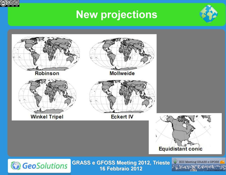
16 Advanced Projection Handling Management of dateline Change and map-wrapping Cutting un-reprojectable geometries

17 Advanced Styling Filter Functions Geometry Transformations Number Formatting Drop Shadow

18 Rendering transformations On-the-fly data transformations Calling WPS processes from SLD docs Optimized for performance

19 Rendering transformations Point feature extraction from two band raster data (e.g. Wind(u,v)) Computation of direction and module from SLD
) Computation of")
20 Time and elevation support Available on 2.2.x Supports both vector (fields) and rasters (mosaics with time/elevation associated to tiles) GetMap&time= T18:00:00Z/ T00:00:00Z GetMap&time= T18:00:00Z/ T00:00:00Z


21 WMS Animator Animations for WMS requests across custom GetMap params Controlled via aparam/avalues couples Generates multiple frames through multiple GetMap requests m=time&avalues= t00:00:00.000z,, T00:00:00.000Z&format=image/gif;subtype=animated&format_options=gif_l oop_continuosly:true
22 Cross-Layer filtering querylayer community module Find all sites within 100 meters from roads Single CQL filter with WMS: DWITHIN( the_geom, collectgeometries( querycollection('roads', 'the_geom', 'INCLUDE') ), 200, meters)
23 INSPIRE INSPIRE community module Adds new layer metadata fields Integrate the WMS capabilities documents to support the INSPIRE requirements
24 WMS Cascading Cascade WMS 1.1 and WMS 1.3 Auto-fill metadata based on caps document GetMap and GetFeatureInfo Cascading Support for reprojection on-the-fly GUI based mass import of remote layers Support for secured remote WMS services
25 WFS Dissemination and filtering of vector data WFS 1.0 and 1.1 support with transactions WFS 2.0 on the 2.2.x series Formats: GML 2, 3.1 e 3.2, CSV, GeoRSS, GeoJSON Shapefile (zipped), OGR (via ogr2ogr, configurable) Extensions CQL WFS 1.0 with on-the-fly reprojection Paging and sorting in WFS 1.0 and 1.1
26 WFS paging service=wfs&version=1.0.0&request=getfeature &typename=topp:states&outputformat=csv &propertyname=state_name,persons &maxfeatures=10&startindex=10 #FID,STATE_NAME,PERSONS states.11,arizona, states.12,oklahoma, states.13,north Carolina, states.14,tennessee, states.15,texas, states.16,new Mexico, states.17,alabama, states.18,mississippi, states.19,georgia, states.20,south Carolina,
27 WCS* Raster data dissemination Raw raster data useful for analysis, no maps! Support for TIME and ELEVATION (via ImageMosaic plugin) WCS 1.0 e Output formats GeoTiff, ArcGrid GDAL based formats* Extensions ELEVATION as band management*


28 WCS: request builder and limits
29 WPS WPS 1.0 Official Extension Raster and Vector data support High performance processes development (raster/vector statistics, raster/vector format conversions and more) Supports asynchronous requests Integrated WPS Automatic publishing of results Embedding processes into SLD styles Reuse processes as rendering transformations
30 WPS: news
31 WPS* Deficiencies Missing request limits enforcements (e.g. input/output maximum dimensions) Wish list: Scripting (Jython, GeoScript) Sextante, IDL, JGrass (Grass?) integration Improved robustness Jiffle (jai-tools) based raster algebra Create new layers as dynamic WPS processes (computing data on the fly as requested)
32 Data
33 New/improved vector stores Teradata (large databases + analytics/business intelligence) SQL Server: improved performance, added support for SQL Azure GeoCouch* (couch db) GeoGit* (distributed versioning) Simple Feature Service* client (aka MapFish++ protocol) New OGR data store* Aggregating data store* *: new/experimental
34 Aggregating data store N layers, remote or local, sharing the same structure Aggregating store puts them together dynamically, the client will think there is just one layer Parallel data fetching Can be configured to tolerate temporarily unreachable data sources
35 SQL Parametric Views SQL View as a GeoServer Layer No need to actually creating a view in the database View can be parametric WMS and WFS allow parameter substitution.&request=getmap&viewparams=low: ;high: Default values for parameters Validation with regular expressions
36 ImageIO-Ext Support JAI ImageIO Extension Plugins: BigTiff netcdf-cf, GriB1 MatFile 5 HDF4 JP2000 (Kakadu) GDAL GDAL integration via ImageIO-ext JPEG2000,MrSID, ECW BigTIFF, ERDAS Image, HDF4
37 Image Server* Turning GeoServer into an Image Server Serving pure Imagery No geo-reference need/available/(would make sense!) Special Coordinate Reference Systems defined Interoperability with WMS clients Respecting EPSG conventions EPSG: See here Improved support for data with bad/missing geo-reference!
38 Security
39 Integrated Security Spring Security RBAC on layers and services Built-in version with simplified rules namespace.layer.mode=role1,role2,... A name, or * to mean any r: read w: write The roles that will be authorized to access the data under this rule
40 Security Developments in 2.1 Security Management at the feature level (record in DBMS) read and write filtering Hide sensible attributes Discriminate visible areas on a per-user basis Rules for services and layers Server side framework available, but no integrated solution leveraging it. External tools available: GeoRepository, GeoShield
41 GeoRepository GeoRepository
42 Database level security Some enterprises want to control security at the database level (instead of at the application level) The connection pool user gets very limited rights Pass down the current GeoServer user to the database via SQL script
43 Security Developments in 2.2.x Some new security advances are in the works on the unstable series, will be available in 2.2.0: Pluggable authentication layer (use authentications others than HTTP BASIC ones) Pluggable user/roles database Password encryption in configuration files
44 The End Questions?
45 Raster Symbolizer Raw Data 256 Colors Colors
46 Administration GUI
47 GUI: security configuration
48 Integrated Security *.*.r=* *.*.w=no_one RDONLY lock down private.*.r=trusted_role private.*.w=trusted_role topp.districts.w=legislators Per-layer override private.* topp.* topp. districts Other layers TRUSTED_ROLE r/w r r r LEGISLATORS (all other users) (no access) r r/w r (no access) r r r
49 Security Developments in 2.1 GSIP 57 extended authorization management GeoRepository Role Base Access Control Services Operations Layers Attributes (alphanumeric and geospatial) External Web Application Web Services + UI Rule-based IPTables-like
50 Complex Feature* Application/community schemas Complex Features Attributes as sub-features Attributes as list of features Tree-like structure Heterogeneous data sources INSPIRE!
51 Dynamic symbolizers
52 Advanced Labeling Advanced Styling
53 WMS - CQL GeoServer WMS CQL Examples STATE_NAME = 'Montana' MALE > FEMALE LAND_KM >
54 WMS TIME and ELEVATION TIME = T Z ELEVATION = 0.0 FeatureType Editor
55 Raster Pyramids Preprocessing raster data for performance Multiple resolutions levels Scale decide best resolution level Multiple file (tiles) per resolutions level File Based Pyramids Support DBMS-based Pyramids Postgis DB2 Oracle (GeoRaster) MySQL
56 WPS: demo builder
57 Improved Raster Reprojection Raster reprojection complex process Idea: try to approximate the overall transformation with a simpler one, either a single affine transformation or a piecewise composition of them (grid warp) Ability to specify threshold for error acceptance Iterative approach (local optimization) Trade off between speed and precision
58 GeoWebCache Integration GeoServer GeoWebCache Persistent raster/kml tile cache Direct calls to GeoServer rendering engine Support for layers modified through WFT-T Support for various tile protocols GMap, Gearth OpenLayers, VEarth, Bing Speed-up factor 10/100 Disk quota support
59 GeoServer in da Cloud Standing Cloud Admin-Free Cloud Infrastructure Paas from Amazon, GoGrid, Linode, etc Pay per use Elastic resources at hand GeoServer SaaS Deploy and admin with UI No sysadmin skills Shell available for braves!
Introduzione a Geoserver - Sviluppi in corso per lo studio del Climate Change
 Introduzione a Geoserver - Sviluppi in corso per lo studio del Climate Change Ing. Simone Giannecchini, GeoSolutions Ing. Andrea Antonello, Hydrologis Outline GeoSolutions Facts GeoServer 2.0 Funzionalità
Choosing the right GIS framework for an informed Enterprise Web GIS Solution
 13 ANNUAL INTERNATIONAL CONFERENCE AND EXHIBITION ON GEOSPATIAL INFORMATION TECHNOLOGY AND APPLICATIONS Epicentre; Gurgaon, India; 19-21 January, 2010 Choosing the right GIS framework for an informed Enterprise
The ORIENTGATE data platform
 Seminar on Proposed and Revised set of indicators June 4-5, 2014 - Belgrade (Serbia) The ORIENTGATE data platform WP2, Action 2.4 Alessandra Nuzzo, Sandro Fiore, Giovanni Aloisio Scientific Computing and
GeoNetwork, The Open Source Solution for the interoperable management of geospatial metadata
 GeoNetwork, The Open Source Solution for the interoperable management of geospatial metadata Ing. Emanuele Tajariol, GeoSolutions Ing. Simone Giannecchini, GeoSolutions GeoSolutions GeoSolutions GeoNetwork
Oklahoma s Open Source Spatial Data Clearinghouse: OKMaps
 Oklahoma s Open Source Spatial Data Clearinghouse: OKMaps Presented by: Mike Sharp State Geographic Information Coordinator Oklahoma Office of Geographic Information MAGIC 2014 Symposium April 28-May1,
Standardized data sharing through an open-source Spatial Data Infrastructure: the Afromaison project
 Standardized data sharing through an open-source Spatial Data Infrastructure: the Afromaison project Yaniss Guigoz - University of Geneva/GRID-Geneva 1 EcoARM2ERA and AFROMAISON Why Afromaison in this
Institute of Computational Modeling SB RAS
 Institute of Computational Modeling SB RAS ORGANIZATION OF ACCESS TO OBSERVATIONAL DATA USING WEB SERVICES FOR MONITORING SYSTEMS THE STATE OF THE ENVIRONMENT Kadochnikov Aleksey A. Russia, Krasnoyarsk
INTEROPERABLE IMAGE DATA ACCESS THROUGH ARCGIS SERVER
 INTEROPERABLE IMAGE DATA ACCESS THROUGH ARCGIS SERVER Qian Liu Environmental Systems Research Institute 380 New York Street Redlands, CA92373, U.S.A - [email protected] KEY WORDS: OGC, Standard, Interoperability,
GeoMedia Product Update. Title of Presentation. Lorilie Barteski October 15, 2008 Edmonton, AB
 Product Update Title of Presentation Lorilie Barteski Edmonton, AB Know the audience poll Existing /Pro users Version 6.1 Version 6.0 Version 5.2 or earlier Existing WebMap users Version 6.1 Version 6.0
Project eharta: a collaborative initiative to digitally preserve and freely share old cartographic documents in Romania
 Vasile Crăciunescu, Ştefan Constantinescu, IonuŃ Ovejanu, Ioan Rus Project eharta: a collaborative initiative to digitally preserve and freely share old cartographic documents in Romania Keywords: geo-spatial.org;
VISUAL INSPECTION OF EO DATA AND PRODUCTS - OVERVIEW
 WMS services from the EUMETSAT real-time Image Gallery Uwe Voges (1), Michael Schick (2), Udo Einspanier (1) (1) con terra GmbH Martin-Luther-King-Weg 24, 48155, Münster, Germany EMail: (U.Voges U.Einspanier)@conterra.de
GeoKettle: A powerful open source spatial ETL tool
 GeoKettle: A powerful open source spatial ETL tool FOSS4G 2010 Dr. Thierry Badard, CTO Spatialytics inc. Quebec, Canada [email protected] Barcelona, Spain Sept 9th, 2010 What is GeoKettle? It is
Big Data Volume & velocity data management with ERDAS APOLLO. Alain Kabamba Hexagon Geospatial
 Big Data Volume & velocity data management with ERDAS APOLLO Alain Kabamba Hexagon Geospatial Intergraph is Part of the Hexagon Family Hexagon is dedicated to delivering actionable information through
Sisense. Product Highlights. www.sisense.com
 Sisense Product Highlights Introduction Sisense is a business intelligence solution that simplifies analytics for complex data by offering an end-to-end platform that lets users easily prepare and analyze
Neues vom QGIS Server und QGIS-Webclient
 FOSSGIS 2012 Neues vom QGIS Server und QGIS-Webclient Pirmin Kalberer Sourcepole AG, Pfäffikon SZ www.sourcepole.ch Über Sourcepole > QGIS > Core dev. & Project Steering Commitee > Printing, QGIS Server,
Open Source Visualisation with ADAGUC Web Map Services
 Open Source Visualisation with ADAGUC Web Map Services Maarten Plieger Ernst de Vreede John van de Vegte, Wim Som de Cerff, Raymond Sluiter, Ian van der Neut, Jan Willem Noteboom 1 ADAGUC project Cooperative
Analysis of the Free GIS Software Applications in respect to INSPIRE services and OGC standards
 Analysis of the Free GIS Software Applications in respect to INSPIRE services and OGC standards Authors: Francesco D'Alesio Peter Hopfgartner Paolo Viskanic June 2011 Executive Summary This document analyses
Web Mapping in Archaeology
 Non-invasive methods in the contemporary archaeological practice 25th February 2014 http://www.pborycki.pl/pdf/webmapping.pdf Plan of the presentation 1 Web Mapping General Idea History of Web Mapping
How To Use Gis
 Welcome Understanding Purpose Creating Relationships You A Global Community of GIS Professionals Changing the World Together Applying Geography Everywhere Your WORK Showcasing Your Web Apps Vision Applying
Choosing the right GIS framework for an informed Enterprise Web GIS Solution
 Choosing the right GIS framework for an informed Enterprise Web GIS Solution Written By Sneha Rao ([email protected]) and Sri Vinay ([email protected]) CIESIN, Columbia University & NASA New
From Geoportal to Spatial Data Service Platform. Jani Kylmäaho National Land Survey of Finland Development Centre
 From Geoportal to Spatial Data Service Platform Jani Kylmäaho National Land Survey of Finland Development Centre 29.6.2012 Introduction National Land Survey of Finland - 1900 employees Development Centre
Open Source GIS Blitz!
 Open Source GIS Blitz! Startwiththisvideo http://vimeo.com/2598878 Openstreetmap.org Crown copyright no expiration all government map data in England. Rest of Europe not much better Volunteer mapping effort.
Chapter 6: Data Acquisition Methods, Procedures, and Issues
 Chapter 6: Data Acquisition Methods, Procedures, and Issues In this Exercise: Data Acquisition Downloading Geographic Data Accessing Data Via Web Map Service Using Data from a Text File or Spreadsheet
smespire - Exercises for the Hands-on Training on INSPIRE Network Services April 2014 Jacxsens Paul SADL KU Leuven
 smespire - Exercises for the Hands-on Training on INSPIRE Network Services April 2014 Jacxsens Paul SADL KU Leuven These exercises aim at people who already have some basic knowledge of INSPIRE Network
Enterprise GIS Solutions to GIS Data Dissemination
 Enterprise GIS Solutions to GIS Data Dissemination ESRI International User Conference July 13 17, 2009 Wendy M. Turner Senior GIS Engineer & Program Manager Freedom Consulting Group, LLC Building the Enterprise
Documentation of open source GIS/RS software projects
 Contract no. Workpackage Delivery Delivery Date 030776 WP1 D1.6 2007-07-02 CASCADOSS Development of a trans-national cascade training programme on Open Source GIS&RS Software for environmental applications
ERDAS APOLLO 2009. How to manage/catalog/share Raster & vector data. ERDAS, Inc. A Hexagon Company. All Rights Reserved 1
 ERDAS APOLLO 2009 How to manage/catalog/share Raster & vector data ERDAS, Inc. A Hexagon Company. All Rights Reserved 1 Here we are; Again Leica Geosystems Geospatial Imaging is now ERDAS, Inc. ERDAS,
Web and Mobile GIS Applications Development
 Web and Mobile GIS Applications Development Presented by : Aamir Ali Manager Section Head (GIS Software Customization) Pakistan Space and Upper Atmosphere Research Commission (SUPARCO) Geographical Information
What's new in gvsig Desktop 2.0
 What's new in gvsig Desktop 2.0 What are the novelties? 2.0 1.12 Migrating and building... Some examples... Please pardon our appearance during construction Pie and bar chart legends Table in layout 1.12
Geographic Web Application
 University of L Aquila Department of Electrical and Information Engineering Geographic Web Application Enrico Ippoliti Building complete web applications This section discuss how to build complete web
NetCDF and HDF Data in ArcGIS
 2013 Esri International User Conference July 8 12, 2013 San Diego, California Technical Workshop NetCDF and HDF Data in ArcGIS Nawajish Noman Kevin Butler Esri UC2013. Technical Workshop. Outline NetCDF
Open Source Geospatial Software. Bob Bruce, P.Eng Mapping and Lands Branch, Manitoba Conservation WWW.HWPS.CA [email protected]
 A Survey of Open Source Geospatial Software Bob Bruce, P.Eng Mapping and Lands Branch, Manitoba Conservation WWW.HWPS.CA [email protected] APEGM PD Breakfast Tuesday, 12 June 2007 access this presentation
SUMMER SCHOOL ON ADVANCES IN GIS
 SUMMER SCHOOL ON ADVANCES IN GIS Six Workshops Overview The workshop sequence at the UMD Center for Geospatial Information Science is designed to provide a comprehensive overview of current state-of-the-art
_ LUCIADRIA PRODUCT DATA SHEET
 _ LUCIADRIA PRODUCT DATA SHEET V2015.1 LuciadRIA offers browser-based geospatial situational awareness with the fluidity and speed of a desktop application. The software components of LuciadRIA have been
UK Location Programme
 Location Information Interoperability Board Data Publisher How To Guide Understand the background to establishing an INSPIRE View Service using GeoServer DOCUMENT CONTROL Change Summary Version Date Author/Editor
OPEN STANDARD WEB SERVICES FOR VISUALISATION OF TIME SERIES DATA OF FLOOD MODELS
 OPEN STANDARD WEB SERVICES FOR VISUALISATION OF TIME SERIES DATA OF FLOOD MODELS Barend Köbben FRMRC RPA 7 Workshop visualisations and flow simulations as flood risk communication tools
Design Requirements for an AJAX and Web-Service Based Generic Internet GIS Client
 11th AGILE International Conference on Geographic Information Science 2008 Page 1 of 6 Design Requirements for an AJAX and Web-Service Based Generic Internet GIS Client Edward Nash 1, Peter Korduan 1,
GeoNetwork, The Open Source Solution for the interoperable management of geospatial metadata
 GeoNetwork, The Open Source Solution for the interoperable management of geospatial metadata Ing. Simone Giannecchini, GeoSolutions Ing. Emanuele Tajariol, GeoSolutions Outline GeoNetwork Introduction
Web Map Service Architecture for Topographic Data in Finland
 Web Map Service Architecture for Topographic Data in Finland Teemu Sipilä National Land Survey of Finland Abstract. Since 2012 National Land Survey of Finland has been renewing its web map services and
Smart Cities require Geospatial Data Providing services to citizens, enterprises, visitors...
 Cloud-based Spatial Data Infrastructures for Smart Cities Geospatial World Forum 2015 Hans Viehmann Product Manager EMEA ORACLE Corporation Smart Cities require Geospatial Data Providing services to citizens,
Comparison of Open Source Virtual Globes
 FOSS4G 2010 Comparison of Open Source Virtual Globes Mathias Walker Pirmin Kalberer Sourcepole AG, Bad Ragaz www.sourcepole.ch About Sourcepole GIS-Knoppix: first GIS live-cd QGIS Core developer QGIS Mapserver
http://opendata.comune.fi.it
 The Environmental Observation Web and its Service Applications within the Future Internet OPENDATA IN CITY OF FLORENCE Gianluca Vannuccini Head of the IT Infrastructure Development Office IT Department
Jozef Matula. Visualisation Team Leader IBL Software Engineering. 13 th ECMWF MetOps Workshop, 31 th Oct - 4 th Nov 2011, Reading, United Kingdom
 Visual Weather web services Jozef Matula Visualisation Team Leader IBL Software Engineering Outline Visual Weather in a nutshell. Path from Visual Weather (as meteorological workstation) to Web Server
EUMETSAT EO Portal. End User Image Access using OGC WMS/WCS services. EUM/OPS/VWG/10/0095 Issue <1> <14/01/2010> Slide: 1
 EUMETSAT EO Portal End User Image Access using OGC WMS/WCS services Slide: 1 Overview Introduction: status of data access and visualization EUMETSAT datasets Architecture Web Map Service implementation
County of Los Angeles. Chief Information Office Preferred Technologies for Geographic Information Systems (GIS) September 2014
 September 2014") County of Los Angeles Chief Information Office Preferred Technologies for Geographic Information Systems (GIS) September 2014 CIO Preferred Technologies for GIS This document lists the preferred Geographic
County of Los Angeles Chief Information Office Preferred Technologies for Geographic Information Systems (GIS) September 2014 CIO Preferred Technologies for GIS This document lists the preferred Geographic
What s new in Carmenta Server 4.2
 What s new in Carmenta Server 4.2 A complete solution for cost-effective visualisation and distribution of GIS data through web services Carmenta Server provides cost-effective technology for building
SuperGIS Server 3.2 Standard Edition Specification
 SuperGIS Server 3.2 Standard Edition Specification 20140826 Specification 1. All of the services support SOAP (Simple Object Access Protocol). 2. Use map file created by SuperGIS Desktop as map services
An Introduction to Open Source Geospatial Tools
 An Introduction to Open Source Geospatial Tools by Tyler Mitchell, author of Web Mapping Illustrated GRSS would like to thank Mr. Mitchell for this tutorial. Geospatial technologies come in many forms,
Implementation of information system to respond to a nuclear emergency affecting agriculture and food products - Case of Morocco
 Centre National de l énergie des sciences et techniques nucléaires (CNESTEN-Morocco) Implementation of information system to respond to a nuclear emergency affecting agriculture and food products - Case
GeoPackage, The Shapefile Of The Future
 FOSS4G 2013 GeoPackage, The Shapefile Of The Future @PirminKalberer Sourcepole AG, Switzerland www.sourcepole.com About Sourcepole > QGIS > Core dev. & Project Steering Commitee > QGIS Server, Printing,
Application Development Using Image Services Web APIs. Hong Xu, Wenxue Ju
 Application Development Using Image Services Web APIs Hong Xu, Wenxue Ju Session Outline Discuss and demonstrate the following image service web application patterns: Display image service in your web
IDL. Get the answers you need from your data. IDL
 Get the answers you need from your data. IDL is the preferred computing environment for understanding complex data through interactive visualization and analysis. IDL Powerful visualization. Interactive
GeoKettle: A powerful spatial ETL tool for feeding your Spatial Data Infrastructure (SDI)
") GeoKettle: A powerful spatial ETL tool for feeding your Spatial Data Infrastructure (SDI) Dr. Thierry Badard, CTO [email protected] Spatialytics http://www.spatialytics.com FOSS4G 2011 Workshop,
GeoKettle: A powerful spatial ETL tool for feeding your Spatial Data Infrastructure (SDI) Dr. Thierry Badard, CTO [email protected] Spatialytics http://www.spatialytics.com FOSS4G 2011 Workshop,
FME 2007 Release Giving Raster the Vector Treatment. By Mary Jo Wagner
 FME 2007 Release Giving Raster the Vector Treatment By Mary Jo Wagner Giving Raster the Vector Treatment By Mary Jo Wagner Spatial extract, transform and load (ETL) tools such as Safe Software s FME have
OSGeo Web Mapping Typification: GeoMajas, Mapbender, MapFish and OpenLayers. Christoph Baudson Arnulf Christl FOSS4G 2010 Barcelona
 OSGeo Web Mapping Typification: GeoMajas, Mapbender, MapFish and OpenLayers Christoph Baudson Arnulf Christl FOSS4G 2010 Barcelona Disclaimer All information contained in this presentation has been compiled
Enabling embedded maps
 Enabling embedded maps Case: National geoportal of Finland Antti Rainio National Land Survey of Finland Trends: Web Services, Mapping Mashup, Open Source, Open Data Decentralised data s Service interfaces
DataTube: web services voor data
 DataTube: web services voor data Gerben de Boer Onno van de Akker Gerrit Hendriksen Deltares, Matroos Deltares, FEWS Deltares, NHI FEWS & Matroos: database > viewers VIEWER client 3 rd party viewer Matroos
Web-based spatio-temporal visualization and analysis of the Siberian Earth System Science Cluster (SIB-ESS-C)
") Web-based spatio-temporal visualization and analysis of the Siberian Earth System Science Cluster (SIB-ESS-C) Roman Gerlach Supervisor: Prof. C. Schmullius (Dept. of Geography, Friedrich-Schiller-University
Web-based spatio-temporal visualization and analysis of the Siberian Earth System Science Cluster (SIB-ESS-C) Roman Gerlach Supervisor: Prof. C. Schmullius (Dept. of Geography, Friedrich-Schiller-University
_ LUCIADLIGHTSPEED PRODUCT DATA SHEET
 _ LUCIADLIGHTSPEED PRODUCT DATA SHEET V2015.1 1 LuciadLightspeed is a software product that enables you to rapidly develop situational awareness applications. It provides a base application and software
J9.6 GIS TOOLS FOR VISUALIZATION AND ANALYSIS OF NEXRAD RADAR (WSR-88D) ARCHIVED DATA AT THE NATIONAL CLIMATIC DATA CENTER
 ARCHIVED DATA AT THE NATIONAL CLIMATIC DATA CENTER") J9.6 GIS TOOLS FOR VISUALIZATION AND ANALYSIS OF RADAR (WSR-88D) ARCHIVED DATA AT THE NATIONAL CLIMATIC DATA CENTER Steve Ansari * STG Incorporated, Asheville, North Carolina Stephen Del Greco NOAA National
J9.6 GIS TOOLS FOR VISUALIZATION AND ANALYSIS OF RADAR (WSR-88D) ARCHIVED DATA AT THE NATIONAL CLIMATIC DATA CENTER Steve Ansari * STG Incorporated, Asheville, North Carolina Stephen Del Greco NOAA National
Creating Service Definition file while disconnected from the server
 Service Definition File Creating Service Definition file while disconnected from the server When disconnected from the server you will configure your service definition with no available connection to
Institute of Natural Resources Departament of General Geology and Land use planning Work with a MAPS
 Institute of Natural Resources Departament of General Geology and Land use planning Work with a MAPS Lecturers: Berchuk V.Y. Gutareva N.Y. Contents: 1. Qgis; 2. General information; 3. Qgis desktop; 4.
Vision. South Pacific GIS/RS Conference 2015 11/17/2015. Applying Geography Everywhere. Applying Geography Everywhere
 South Pacific GIS/RS Conference 2015 Applying Geography Everywhere Jithen (J) Singh Eagle Technology Group Ltd (Esri New Zealand) Suva, Fiji Vision Applying Geography Everywhere 1 GIS Is Evolving A Whole
Developer Tutorial Version 1. 0 February 2015
 Developer Tutorial Version 1. 0 Contents Introduction... 3 What is the Mapzania SDK?... 3 Features of Mapzania SDK... 4 Mapzania Applications... 5 Architecture... 6 Front-end application components...
Intergraph Geospatial Portfolio 2013
 W H A T S N E W? Intergraph Geospatial Portfolio 2013 Photogrammetry LPS ImageStation Remote Sensing ERDAS IMAGINE GIS GeoMedia Server GeoMedia WebMap GeoMedia Smart Client ERDAS APOLLO Geospatial SDI
ArcGIS. Server. A Complete and Integrated Server GIS
 ArcGIS Server A Complete and Integrated Server GIS ArcGIS Server A Complete and Integrated Server GIS ArcGIS Server enables you to distribute maps, models, and tools to others within your organization
Secure your GIS. Protecting GIS applications suites. camptocamp / 9. septembre 2010 / www.camptocamp.com / [email protected]
 Secure your GIS Protecting GIS applications suites camptocamp / 9. septembre 2010 / www.camptocamp.com / [email protected] Outline - Camptocamp SA - Introduction Green field Heterogenous FOSS applications
Open Source GIS The Future?
 Open Source GIS The Future? Daniel Morissette DM Solutions Group Inc. Open Source Licensing No licensing costs Unlimited rights to: Use the software View and analyse the source Copy, reuse in other systems
A Hybrid Architecture for Mobile Geographical Data Acquisition and Validation Systems
 A Hybrid Architecture for Mobile Geographical Data Acquisition and Validation Systems Claudio Henrique Bogossian 1, Karine Reis Ferreira 1, Antônio Miguel Vieira Monteiro 1, Lúbia Vinhas 1 1 DPI Instituto
CLOUD BASED N-DIMENSIONAL WEATHER FORECAST VISUALIZATION TOOL WITH IMAGE ANALYSIS CAPABILITIES
 CLOUD BASED N-DIMENSIONAL WEATHER FORECAST VISUALIZATION TOOL WITH IMAGE ANALYSIS CAPABILITIES M. Laka-Iñurrategi a, I. Alberdi a, K. Alonso b, M. Quartulli a a Vicomteh-IK4, Mikeletegi pasealekua 57,
Server GIS. What Server GIS software do we provide?
 Server GIS Distribute maps, models, and tools via the Web in a way that fits well into your workflows. SuperGeo offers numerous Server GIS solutions to fulfill the demands of corporate Intranets and the
CURSO Inspire INSPIRE. SPEAKER: Pablo Echamendi Lorente. JEUDI 23/ THURSDAY 23 rd W S V : G E O S P A T I A L D A T A A C C E S S
 CURSO Inspire JEUDI 23/ THURSDAY 23 rd SPEAKER: Pablo Echamendi Lorente WS 5 SCHEDULE WMS OVERVIEW ACTIONS OGC SPECIFICATIONS OTHER SERVICES OVERVIEW proposal: Member States shall establish and operate
Statusreport MapServer
 Statusreport MapServer Version 7.0 Wir erschließen das räumliche Potenzial Ihrer Daten. Seit 1997 GIS- und WebGIS-Projekte mit freier Software Entwicklung Anpassung Support Schulungen Wir erschließen das
GIS AS A DECISION SUPPORT FOR SUPPLY CHAIN MANAGEMENT
 Paper Reference No.: PN-253 GIS AS A DECISION SUPPORT FOR SUPPLY CHAIN MANAGEMENT Sanjay Kumar 1 and Suneeta Agrawal 2 1. M. Tech. (GIS & Remote Sensing); GIS Cell; MNNIT, Allahabad, India (E-mail: [email protected])
Managing a Geographic Database From Mobile Devices Through OGC Web Services
 Managing a Geographic Database From Mobile Devices Through OGC Web Services Nieves R. Brisaboa 1, Miguel R. Luaces 1, Jose R. Parama 1, and Jose R. Viqueira 2 1 Database Laboratory, University of A Coruña,
Geo-Platform Introduction
 Geo-Platform Introduction Dimitri Dello Buono @ geosdi 16 Sept 2013 CNR IRPI Perugia Questo lavoro è concesso in uso secondo i termini di una licenza Creative Commons (vedi ultima pagina) geosdi CNR IMAA
OGC at KNMI: Current use and plans Available products
 OGC at KNMI: Current use and plans Available products Maarten Plieger KNMI R&D Ernst de Vreede, John van de Vegte, Wim Som de Cerff, Ian van der Neut, Raymond Sluiter, Jan Willem Noteboom Contents 1. ADAGUC
Open Source GIS. Open Source GIS. Agenda. Open Source. Typische GIS Funktionen. LOTS Bern 18.2.05
 Agenda LOTS Bern 18.2.05 Pirmin Kalberer Sourcepole AG, Bad Ragaz www.sourcepole.ch Typische GIS Anwendungen Datenformate und GIS-Datenbanken Standards & Protokolle Bibliotheken & Applikationen Fragen
SkylineGlobe - Products Overview
 SkylineGlobe - Products Overview Skyline Software Systems, Inc. is a leading provider of 3D earth visualization software and services. The company offers a comprehensive platform of applications, tools
Leveraging Cloud-Based Mapping Solutions
 Leveraging Cloud-Based Mapping Solutions GeoAlberta October 28, 2014 Laura Kerssens Safe Software Agenda To the Cloud Using Basic Services Cloud Applications Web Services Cloud-Hosted Databases Real-time
Actuate Business Intelligence and Reporting Tools (BIRT)
") Product Datasheet Actuate Business Intelligence and Reporting Tools (BIRT) Eclipse s BIRT project is a flexible, open source, and 100% pure Java reporting tool for building and publishing reports against
Product Datasheet Actuate Business Intelligence and Reporting Tools (BIRT) Eclipse s BIRT project is a flexible, open source, and 100% pure Java reporting tool for building and publishing reports against
INSPIRE in practice: Experiences with INSPIRE data and services
 INSPIRE in practice: Experiences with INSPIRE data and services Peter Parslow Principal Geographic Information Architect June 2014: ISO TC211 Standards in Practice workshop What s INSPIRE? European Commission
Access to ESPON Database by third- party applications An expertise on the potentialities of web services for accessing the ESPON metadata and data
 Access to ESPON Database by third- party applications An expertise on the potentialities of web services for accessing the ESPON metadata and data UNEP/GRID- Geneva 27/06/2013 ABOUT THIS DOCUMENT A technical
MapServer and OGC Standards in real life (and saving real lives) Daniel Morissette, Mapgears [email protected]
 Daniel Morissette, Mapgears dmorissette@mapgears.com") MapServer and OGC Standards in real life (and saving real lives) Daniel Morissette, Mapgears [email protected] 1 Mapgears Team of MapServer experts (we're the developers) assisting application developers
MapServer and OGC Standards in real life (and saving real lives) Daniel Morissette, Mapgears [email protected] 1 Mapgears Team of MapServer experts (we're the developers) assisting application developers
 Development tools to create Web-GIS applications DbMAP ASJ the best solution to easily publish GIS data from existing spatial databases and distributed GIS data sources Easily designs, produces, and publishes
Data Visualization Using Web GIS Software
 Data Visualization Using Web GIS Software Tuomas Peltonen Radiation and Nuclear Safety Authority (STUK), Finland NKS NordDSS Workshop, Copenhagen, 1.-2.10.2009 RADIATION AND NUCLEAR SAFETY AUTHORITY Preface
Deploying a Geospatial Cloud
 Deploying a Geospatial Cloud Traditional Public Sector Computing Environment Traditional Computing Infrastructure Silos of dedicated hardware and software Single application per silo Expensive to size
ORACLE APPLICATION EXPRESS 5.0
 ORACLE APPLICATION EXPRESS 5.0 Key Features Fully supported nocost feature of the Oracle Database Simple 2-Tier Architecture Develop desktop and mobile applications 100% Browserbased Development and Runtime
GeoMedia Smart Client
 GEOSPATIAL GeoMedia Smart Client Dynamically Jumpstart Your GIS GeoMedia Smart Client Is your geographic information system (GIS) at a gridlock, stuck in a department, limited to a few, contained and
Cloud-based Geospatial Data services and analysis
 Cloud-based Geospatial Data services and analysis Xuezhi Wang Scientific Data Center Computer Network Information Center Chinese Academy of Sciences 2014-08-25 Outlines 1 Introduction of Geospatial Data
Cloud-based Infrastructures. Serving INSPIRE needs
 Cloud-based Infrastructures Serving INSPIRE needs INSPIRE Conference 2014 Workshop Sessions Benoit BAURENS, AKKA Technologies (F) Claudio LUCCHESE, CNR (I) June 16th, 2014 This content by the InGeoCloudS
Developing Business Intelligence and Data Visualization Applications with Web Maps
 Developing Business Intelligence and Data Visualization Applications with Web Maps Introduction Business Intelligence (BI) means different things to different organizations and users. BI often refers to
WCS as a Download Service for Big (and Small) Data
 Data") WCS as a Download Service for Big (and Small) Data INSPIRE 2013 Florence, Italy, 2013-jun-25 Peter Baumann 1, Stephan Meissl 2, Alan Beccati 1 1 Jacobs University rasdaman GmbH, Bremen, Germany 2 EOX GmbH,
WCS as a Download Service for Big (and Small) Data INSPIRE 2013 Florence, Italy, 2013-jun-25 Peter Baumann 1, Stephan Meissl 2, Alan Beccati 1 1 Jacobs University rasdaman GmbH, Bremen, Germany 2 EOX GmbH,
Cloud Computing and Big Data
 Cloud Computing and Big Data Karl Benedict Earth Data Analysis Center, University Libraries, Department of Geography University of New Mexico [email protected] EDAC An Architecture Designed for Scalability
WEB MAPPING WITH DRUPAL Ranel O. Padon
 WEB MAPPING WITH DRUPAL Ranel O. Padon WHY WEB? connectivity & interaction WHY CMS? WHY CMS? WHY CMS? WHY CMS? WHY CMS? WHY PHP? used by almost 30 Million websites around the world. http://trends.builtwith.com/framework/php
Keystone Image Management System
 Image management solutions for satellite and airborne sensors Overview The Keystone Image Management System offers solutions that archive, catalogue, process and deliver digital images from a vast number