Web Mapping in Archaeology
|
|
|
- Stephany Whitehead
- 10 years ago
- Views:
Transcription
1 Non-invasive methods in the contemporary archaeological practice 25th February

2 Plan of the presentation 1 Web Mapping General Idea History of Web Mapping Open Source Geospatial Foundation 2 MapGuide Open Source MapGuide System Structure Feature Sources Layer Definitions Map Definitions Layout Definitions Data management MapGuide Maestro and XML Editing 3 System Demonstration

3 Web Mapping Map of Angkor Wat in OpenStreetMap General idea Share GIS data in Web Make mapping accessible End monopoly of cartographic agencies Develop free-licensed maps Types of web maps Static maps View-only maps Online atlases Dynamic maps Interactive maps User-generated maps Some view-only maps Real-time maps of traffic, weather

4 Layers of the web map Example of web map layers Vector layers Points Labels, symbols Lines Roads, railways, borders, grid lines Areas Cities, buildings, parks, lakes, trenches Raster layers Satellite images Aerial pictures Scanned paper maps

 1997 UMN MapServer (proprietary) 1999 UMN MapServer (open source) 2004")
5 History of Web Mapping Xerox PARC Map Viewer 1993 Xerox PARC Map Viewer 1995 Argus MapGuide (proprietary) 1996 Mapquest Autodesk MapGuide (proprietary) 1997 UMN MapServer (proprietary) 1999 UMN MapServer (open source) 2004 OpenStreetMap
 1999 UMN MapServer (open source)")
6 History of Web Mapping Google Maps 2005 Autodesk MapGuide (open source) Google Maps Google Earth 2006 OSGeo MapGuide (open source) 2008 Google Map Maker 2010 Bing Maps
 2008 Google Map Maker 2010")
7 Open Source Geospatial Foundation (OSGeo) OSGeo Projects Open Source Geospatial Foundation (OSGeo) Established in 2006 Open geospatial technologies Open geospatial data Collaborative development Projects Feature Data Objects (FDO) Geospatial Data Abstraction Library (GDAL) QGIS MapServer GeoServer MapGuide Open Source
 QGIS MapServer GeoServer MapGuide")
8 MapGuide Open Source MapGuide Open Source GNU LGPL License Programming technologies PHP / JavaScript / Java /.NET External services Apache / Internet Information Services Structure Server-side processing Client-side processing Browser processing

9 MapGuide Open Source Simplified system scheme

10 Structure of the MapGuide system Structure of the MapGuide system
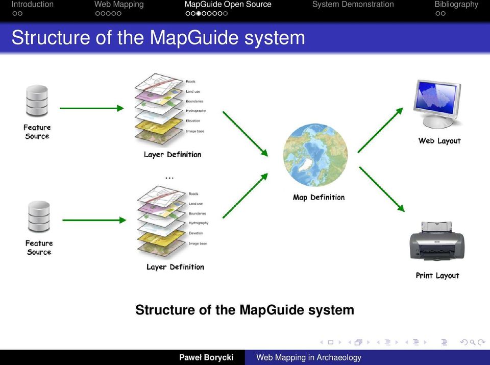
11 Feature Sources Example of data sources Types of Feature Sources Vector File-based Data Esri Shapefile SQLite database MS Access database Vector Relational Data MySQL / Oracle / PostgreSQL Raster Data Geospatial Data Abstraction Library (GDAL) Coordinate System Settings For each Feature Source Well-known text (WKT) format On-the-fly transformation
 format On-the-fly transformation")
12 Layer Definitions Types of Layer Definitions Vector Layers Raster Layers Vector Layer Settings Database properties Styles Points / Lines / Areas Labels Scale intervals Visibility Example of layers

13 Map Definitions Map Configuration Coordinate System Settings On-the-fly Coordinate System Transformation Map Extents Layers Configuration Drawing order Hierarchy building Grouping Base Layers Building Tile Cache MgCooker tool Scale thresholds

14 Layout Definitions Example of web layout Web Layouts AJAX viewer Asynchronous JavaScript and XML Initial view Toolbar and Menu Viewer URL Template Print Layouts Page Properties

15 Tools for data management in MapGuide MapGuide Maestro GUI for building maps Maestro API Python scripts Open source application Windows / UNIX Connection to MapGuide HTTP connection MapGuide API XML Editing Each resource XML file MapGuide data management

16 Introduction Web Mapping MapGuide Open Source System Demonstration Bibliography System Demonstration Examples of running MapGuide service Building a map Ptolemais map Ptolemais map

17 Thank you.

18 Bibliography MapGuide Project Home, [accessed ]. MapGuide Open Source User Manual, [accessed ]. MapGuide Maestro User Manual, [accessed ].

Documentation of open source GIS/RS software projects
 Contract no. Workpackage Delivery Delivery Date 030776 WP1 D1.6 2007-07-02 CASCADOSS Development of a trans-national cascade training programme on Open Source GIS&RS Software for environmental applications
Institute of Computational Modeling SB RAS
 Institute of Computational Modeling SB RAS ORGANIZATION OF ACCESS TO OBSERVATIONAL DATA USING WEB SERVICES FOR MONITORING SYSTEMS THE STATE OF THE ENVIRONMENT Kadochnikov Aleksey A. Russia, Krasnoyarsk
Web and Mobile GIS Applications Development
 Web and Mobile GIS Applications Development Presented by : Aamir Ali Manager Section Head (GIS Software Customization) Pakistan Space and Upper Atmosphere Research Commission (SUPARCO) Geographical Information
Institute of Natural Resources Departament of General Geology and Land use planning Work with a MAPS
 Institute of Natural Resources Departament of General Geology and Land use planning Work with a MAPS Lecturers: Berchuk V.Y. Gutareva N.Y. Contents: 1. Qgis; 2. General information; 3. Qgis desktop; 4.
Developing of A GIS Based Enviromental Monitoring System with Open Source Softwares
 L. Kottyán, G. Nagy, A. Szepes Developing of A GIS Based Enviromental Monitoring System with Open Source Softwares Developing of A GIS Based Enviromental Monitoring System with Open Source Softwares László
Open Source Geospatial Software. Bob Bruce, P.Eng Mapping and Lands Branch, Manitoba Conservation WWW.HWPS.CA [email protected]
 A Survey of Open Source Geospatial Software Bob Bruce, P.Eng Mapping and Lands Branch, Manitoba Conservation WWW.HWPS.CA [email protected] APEGM PD Breakfast Tuesday, 12 June 2007 access this presentation
An Introduction to Open Source Geospatial Tools
 An Introduction to Open Source Geospatial Tools by Tyler Mitchell, author of Web Mapping Illustrated GRSS would like to thank Mr. Mitchell for this tutorial. Geospatial technologies come in many forms,
Open Source GIS Blitz!
 Open Source GIS Blitz! Startwiththisvideo http://vimeo.com/2598878 Openstreetmap.org Crown copyright no expiration all government map data in England. Rest of Europe not much better Volunteer mapping effort.
County of Los Angeles. Chief Information Office Preferred Technologies for Geographic Information Systems (GIS) September 2014
 September 2014") County of Los Angeles Chief Information Office Preferred Technologies for Geographic Information Systems (GIS) September 2014 CIO Preferred Technologies for GIS This document lists the preferred Geographic
County of Los Angeles Chief Information Office Preferred Technologies for Geographic Information Systems (GIS) September 2014 CIO Preferred Technologies for GIS This document lists the preferred Geographic
Neues vom QGIS Server und QGIS-Webclient
 FOSSGIS 2012 Neues vom QGIS Server und QGIS-Webclient Pirmin Kalberer Sourcepole AG, Pfäffikon SZ www.sourcepole.ch Über Sourcepole > QGIS > Core dev. & Project Steering Commitee > Printing, QGIS Server,
Ulyxes automatic deformation monitoring system
 Ulyxes automatic deformation monitoring system Dániel Moka, Szonja Zemkó (Hungary) The CLGE Students Contest 2012 2013 Category: GIS and Mapping and Cadastre 1. Summary We live in a dynamic world. Buildings,
Mapping Mashup/Data Integration Development Resources Teaching with Google Earth and Google Ocean Stone Lab August 13, 2010
 Mapping Mashup/Data Integration Development Resources Teaching with Google Earth and Google Ocean Stone Lab August 13, 2010 David Hart GIS Specialist University of Wisconsin Sea Grant Institute Virtual
Standardized data sharing through an open-source Spatial Data Infrastructure: the Afromaison project
 Standardized data sharing through an open-source Spatial Data Infrastructure: the Afromaison project Yaniss Guigoz - University of Geneva/GRID-Geneva 1 EcoARM2ERA and AFROMAISON Why Afromaison in this
Analysis of the Free GIS Software Applications in respect to INSPIRE services and OGC standards
 Analysis of the Free GIS Software Applications in respect to INSPIRE services and OGC standards Authors: Francesco D'Alesio Peter Hopfgartner Paolo Viskanic June 2011 Executive Summary This document analyses
Developer Tutorial Version 1. 0 February 2015
 Developer Tutorial Version 1. 0 Contents Introduction... 3 What is the Mapzania SDK?... 3 Features of Mapzania SDK... 4 Mapzania Applications... 5 Architecture... 6 Front-end application components...
Outline. CIW Web Design Specialist. Course Content
 CIW Web Design Specialist Description The Web Design Specialist course (formerly titled Design Methodology and Technology) teaches you how to design and publish Web sites. General topics include Web Site
Introduction to OSGeo and QGIS
 Introduction to OSGeo and QGIS Arnulf Christl OSGeo President Emeritus ESTGIS Pühajärve, Estonia Arnulf Christl Geospatial Systems Architect OSGeo President Emeritus Director of the metaspatial Institute
DEVELOPMENT AND COMPARISON OF OPEN SOURCE BASED WEB GIS FRAMEWORKS ON WAMP AND APACHE TOMCAT WEB SERVERS
 DEVELOPMENT AND COMPARISON OF OPEN SOURCE BASED WEB GIS FRAMEWORKS ON WAMP AND APACHE TOMCAT WEB SERVERS Sonam Agrawal a, Rajan Dev Gupta b a GIS Cell, Motilal Nehru National Institute of Technology, Allahabad-211004,
Cloud application for water resources modeling. Faculty of Computer Science, University Goce Delcev Shtip, Republic of Macedonia
 Cloud application for water resources modeling Assist. Prof. Dr. Blagoj Delipetrev 1, Assist. Prof. Dr. Marjan Delipetrev 2 1 Faculty of Computer Science, University Goce Delcev Shtip, Republic of Macedonia
ARCHITECTURE OF INTEGRATED GIS AND GPS FOR VEHICLE MONITORING
 1 st Logistics International Conference Belgrade, Serbia 28-30 November 2013 ARCHITECTURE OF INTEGRATED GIS AND GPS FOR VEHICLE MONITORING Adela B. Crnišanin * State University of Novi Pazar, Department
Open Source GIS The Future?
 Open Source GIS The Future? Daniel Morissette DM Solutions Group Inc. Open Source Licensing No licensing costs Unlimited rights to: Use the software View and analyse the source Copy, reuse in other systems
HANDS-ON WORKSHOP: SPATIAL DATA VISUALIZATION Using selected Open Source tools and Open Data to visualize your own spatial data
 HANDS-ON WORKSHOP: SPATIAL DATA VISUALIZATION Using selected Open Source tools and Open Data to visualize your own spatial data Barend Köbben Version 2.0 September 4, 2014 Contents 1 Open Data: using OpenStreetMap
ArcGIS Server 9.3.1 mashups
 Welcome to ArcGIS Server 9.3.1: Creating Fast Web Mapping Applications With JavaScript Scott Moore ESRI Olympia, WA [email protected] Seminar agenda ArcGIS API for JavaScript: An Overview ArcGIS Server Resource
Vector Web Mapping Past, Present and Future. Jing Wang MRF Geosystems Corporation
 Vector Web Mapping Past, Present and Future Jing Wang MRF Geosystems Corporation Oct 27, 2014 Terms Raster and Vector [1] Cells and Pixel Geometrical primitives 2 Early 2000s From static to interactive
Editing Strategies for Enterprise Geodatabase
 Federal GIS Conference February 9 10, 2015 Washington, DC Editing Strategies for Enterprise Geodatabase Ty Fabling Esri Solution Engineer A Complete Platform Enabling GIS Everywhere Desktop Web Device
Web Design Specialist
 UKWDA Training: CIW Web Design Series Web Design Specialist Course Description CIW Web Design Specialist is for those who want to develop the skills to specialise in website design and builds upon existing
Preface. Motivation for this Book
 Preface Asynchronous JavaScript and XML (Ajax or AJAX) is a web technique to transfer XML data between a browser and a server asynchronously. Ajax is a web technique, not a technology. Ajax is based on
Oklahoma s Open Source Spatial Data Clearinghouse: OKMaps
 Oklahoma s Open Source Spatial Data Clearinghouse: OKMaps Presented by: Mike Sharp State Geographic Information Coordinator Oklahoma Office of Geographic Information MAGIC 2014 Symposium April 28-May1,
OSGeo Web Mapping Typification: GeoMajas, Mapbender, MapFish and OpenLayers. Christoph Baudson Arnulf Christl FOSS4G 2010 Barcelona
 OSGeo Web Mapping Typification: GeoMajas, Mapbender, MapFish and OpenLayers Christoph Baudson Arnulf Christl FOSS4G 2010 Barcelona Disclaimer All information contained in this presentation has been compiled
Geographic Web Application
 University of L Aquila Department of Electrical and Information Engineering Geographic Web Application Enrico Ippoliti Building complete web applications This section discuss how to build complete web
GEOENGINE MSc in Geomatics Engineering, Master Thesis Gina Campuzano
 Master Thesis Gina CAMPUZANO Gina Campuzano Development of a GIS web application as a tool for learning of environmental protection -Comparison between MapServer and GeoServer constructing a tool for not
Iraklis Karampourniotis, Zoi Arvanitidou, Ioannis Paraschakis. Using open source software in gis training and education
 Iraklis Karampourniotis, Zoi Arvanitidou, Ioannis Paraschakis Using open source software in gis training and education Can open source be used? The question troubling us was Can Open Source Software be
DEVELOPMENT OF A WEB GEOSERVICES PLATFORM FOR SCHOOL OF ENVIRONMENTAL SCIENCES, MAHATMA GANDHI UNIVERSITY, KERALA, INDIA
 DEVELOPMENT OF A WEB GEOSERVICES PLATFORM FOR SCHOOL OF ENVIRONMENTAL SCIENCES, MAHATMA GANDHI UNIVERSITY, KERALA, INDIA Sumith Satheendran S. 1, John C. M. 1, Fasalul Faseeh K. 1 and Aanisa K. M. 1,2
Web Development. Owen Sacco. ICS2205/ICS2230 Web Intelligence
 Web Development Owen Sacco ICS2205/ICS2230 Web Intelligence Brief Course Overview An introduction to Web development Server-side Scripting Web Servers PHP Client-side Scripting HTML & CSS JavaScript &
SUMMER SCHOOL ON ADVANCES IN GIS
 SUMMER SCHOOL ON ADVANCES IN GIS Six Workshops Overview The workshop sequence at the UMD Center for Geospatial Information Science is designed to provide a comprehensive overview of current state-of-the-art
VISUAL INSPECTION OF EO DATA AND PRODUCTS - OVERVIEW
 WMS services from the EUMETSAT real-time Image Gallery Uwe Voges (1), Michael Schick (2), Udo Einspanier (1) (1) con terra GmbH Martin-Luther-King-Weg 24, 48155, Münster, Germany EMail: (U.Voges U.Einspanier)@conterra.de
GIS and Mapping Solutions for Developers. ESRI Developer Network (EDN SM)
") GIS and Mapping Solutions for Developers ESRI Developer Network (EDN SM) GIS and Mapping Solutions for Developers If you are a software developer looking for an effective way to bring geographic and mapping
GIS and Mapping Solutions for Developers ESRI Developer Network (EDN SM) GIS and Mapping Solutions for Developers If you are a software developer looking for an effective way to bring geographic and mapping
HANDS-ON WORKSHOP TOOLS FOR SPATIAL DATA VISUALIZATION: Using selected Open Source tools and Open Data to visualize your own spatial data
 HANDS-ON WORKSHOP TOOLS FOR SPATIAL DATA VISUALIZATION: Using selected Open Source tools and Open Data to visualize your own spatial data Barend Köbben Version 1.0 December 12, 2012 Contents 1 Open Data:
General principles and architecture of Adlib and Adlib API. Petra Otten Manager Customer Support
 General principles and architecture of Adlib and Adlib API Petra Otten Manager Customer Support Adlib Database management program, mainly for libraries, museums and archives 1600 customers in app. 30 countries
Lecture 8. Online GIS
 Lecture 8 Online GIS Lecture 8: Outline I. Online GIS 1. Google Earth 2. MSN Live Maps II. Open Source GIS III. ArcGIS Server and the ESRI suite of online software utility options IV. Advanced Data Mining
Project eharta: a collaborative initiative to digitally preserve and freely share old cartographic documents in Romania
 Vasile Crăciunescu, Ştefan Constantinescu, IonuŃ Ovejanu, Ioan Rus Project eharta: a collaborative initiative to digitally preserve and freely share old cartographic documents in Romania Keywords: geo-spatial.org;
Open Source GIS. Open Source GIS. Agenda. Open Source. Typische GIS Funktionen. LOTS Bern 18.2.05
 Agenda LOTS Bern 18.2.05 Pirmin Kalberer Sourcepole AG, Bad Ragaz www.sourcepole.ch Typische GIS Anwendungen Datenformate und GIS-Datenbanken Standards & Protokolle Bibliotheken & Applikationen Fragen
FileMaker Server 11. FileMaker Server Help
 FileMaker Server 11 FileMaker Server Help 2010 FileMaker, Inc. All Rights Reserved. FileMaker, Inc. 5201 Patrick Henry Drive Santa Clara, California 95054 FileMaker is a trademark of FileMaker, Inc. registered
Design Requirements for an AJAX and Web-Service Based Generic Internet GIS Client
 11th AGILE International Conference on Geographic Information Science 2008 Page 1 of 6 Design Requirements for an AJAX and Web-Service Based Generic Internet GIS Client Edward Nash 1, Peter Korduan 1,
_ LUCIADRIA PRODUCT DATA SHEET
 _ LUCIADRIA PRODUCT DATA SHEET V2015.1 LuciadRIA offers browser-based geospatial situational awareness with the fluidity and speed of a desktop application. The software components of LuciadRIA have been
Texas Develops Online Geospatial Data Repository to Support Emergency Management
 Bing Maps for Enterprise Microsoft Customer Solution Case Study Texas Develops Online Geospatial Data Repository to Support Emergency Management Overview Country or Region: United States Industry: Government
4 Understanding. Web Applications IN THIS CHAPTER. 4.1 Understand Web page development. 4.2 Understand Microsoft ASP.NET Web application development
 4 Understanding Web Applications IN THIS CHAPTER 4.1 Understand Web page development 4.2 Understand Microsoft ASP.NET Web application development 4.3 Understand Web hosting 4.4 Understand Web services
Creating a GIS based learning tool for the Faculty of Forest & Environment at the HNE Eberswalde
 Creating a GIS based learning tool for the Faculty of Forest & Environment at the HNE Eberswalde G. Singelnstein / H. Plesse University of Applied Sciences in Eberswalde 14.04.2011 Introduction I What
Adam Rauch Partner, LabKey Software [email protected]. Extending LabKey Server Part 1: Retrieving and Presenting Data
 Adam Rauch Partner, LabKey Software [email protected] Extending LabKey Server Part 1: Retrieving and Presenting Data Extending LabKey Server LabKey Server is a large system that combines an extensive set
A WEB-BASED APPLICATION FOR REAL-TIME GIS
 A WEB-BASED APPLICATION FOR REAL-TIME GIS O. Ozdilek a, *, D. Z. Seker a a ITU, Civil Engineering Faculty, 80626 Maslak Istanbul, Turkey - (ozdilek, seker)@itu.edu.tr KEY WORDS: Spatial Information Sciences,
What is ArcGIS Comprised Of?
 ArcGIS Server 9.1 What is ArcGIS Comprised Of? ArcGIS Desktop Integrated suite of GIS applications ArcGIS Engine Embeddable developer components Server GIS ArcSDE, ArcIMS, ArcGIS Server Mobile GIS ArcPad
Questions and Answers for Citrix Ready Software
 AutoCAD Map 3D 2009 Questions and Answers for Citrix Ready Software AutoCAD Map 3D software is one of the leading engineering platforms for creating and managing spatial data. Bridging the gap between
FileMaker Server 10 Help
 FileMaker Server 10 Help 2007-2009 FileMaker, Inc. All Rights Reserved. FileMaker, Inc. 5201 Patrick Henry Drive Santa Clara, California 95054 FileMaker, the file folder logo, Bento and the Bento logo
Inframoura. Migrating from ArcGIS to Boundless OpenGeo Suite. Diogo Vitorino
 Inframoura Migrating from ArcGIS to Boundless OpenGeo Suite Diogo Vitorino Geospatial World Forum, Lisbon May, 2015 Vilamoura, Portugal Inframoura Vilamoura, Portugal Vilamoura is one of the largest tourist
DATA SHARING AND SPATIAL QUERY
 Technical Memorandum No. 2 DATA SHARING AND SPATIAL QUERY Raghavan Srinivasan Spatial Sciences Laboratory Texas Agricultural Experiment Station, Texas A&M University Submitted to El Paso Water Utilities
Intro to evis: the event visualization tool
 Intro to evis: the event visualization tool Background The of the (CBC) at the (AMNH) developed the Event Visualization Tool (evis), as a conservation monitoring and decision support tool for guiding protected
THINK OPEN, THINK FUTURE
 THINK OPEN, THINK FUTURE How to open polygons and doors using Python Marco Bernasocchi @mbernasocchi Marco Bernasocchi MSc in GIS @ UNIZH Developer, Consultant, Teacher & foremost Geek Skier, Climber,
Introduction to the Mapbender OWS Security Proxy
 Introduction to the Mapbender OWS Security Proxy Arnulf Christl, WhereGroup GmbH & Co. KG, Bonn, Germany 1/16 Agenda 1 Introduction to the Architecture OWS from Bottom Up with the OSGeo SDI Software Stack
Server-Side Scripting and Web Development. By Susan L. Miertschin
 Server-Side Scripting and Web Development By Susan L. Miertschin The OOP Development Approach OOP = Object Oriented Programming Large production projects are created by teams Each team works on a part
There are various ways to find data using the Hennepin County GIS Open Data site:
 Finding Data There are various ways to find data using the Hennepin County GIS Open Data site: Type in a subject or keyword in the search bar at the top of the page and press the Enter key or click the
A Comparative Study of Web Development Technologies Using Open Source and Proprietary Software
 Available Online at www.ijcsmc.com International Journal of Computer Science and Mobile Computing A Monthly Journal of Computer Science and Information Technology IJCSMC, Vol. 4, Issue. 2, February 2015,
1. INTERFACE ENHANCEMENTS 2. REPORTING ENHANCEMENTS
 W E L C O M E T O M O N I T O R I N G H E A V E N NEW THINGS ABOUT PANDORA FMS 5.0 A new version of Pandora FMS full of enhancements is about to hit the market. Pandora FMS 5.0 will be released by the
UK Location Programme
 Location Information Interoperability Board Data Publisher How To Guide Understand the background to establishing an INSPIRE View Service using GeoServer DOCUMENT CONTROL Change Summary Version Date Author/Editor
How To Use Gis
 Welcome Understanding Purpose Creating Relationships You A Global Community of GIS Professionals Changing the World Together Applying Geography Everywhere Your WORK Showcasing Your Web Apps Vision Applying
ArcGIS Server Best Practices and Guidelines
 ArcGIS Server Best Practices and Guidelines NEARC 2007 ESRI Technical Session ESRI, Boston Agenda Components and Deployment OS User Groups and Directory Configuration Service Architectures GIS Security
Mapping Mashup/Data Integration Development Resources
 Mapping Mashup/Data Integration Development Resources David Hart GIS Specialist University of Wisconsin Sea Grant Institute October 6, 2008 Virtual Globes A virtual globe is a 3D software model or representation
Architecture and Mode of Operation
 Software- und Organisations-Service Open Source Scheduler Architecture and Mode of Operation Software- und Organisations-Service GmbH www.sos-berlin.com Scheduler worldwide Open Source Users and Commercial
Spectrum Technology Platform. Version 9.0. Spectrum Spatial Developer Guide
 Spectrum Technology Platform Version 9.0 Spectrum Spatial Developer Guide Contents Chapter 1: Introduction...9 What Is Location Intelligence?...10 What Is the Location Intelligence Module?...10 Location
ArcGIS Web Mapping. Sam Berg, esri [email protected]
 ArcGIS Web Mapping Sam Berg, esri [email protected] Agenda ArcGIS and WebMaps The APIs ArcGIS for Flex Viewer ArcGIS for Silverlight Builder ArcGIS for Sharepoint ArcGIS Application Templates ArcGIS Runtime
OPEN STANDARD WEB SERVICES FOR VISUALISATION OF TIME SERIES DATA OF FLOOD MODELS
 OPEN STANDARD WEB SERVICES FOR VISUALISATION OF TIME SERIES DATA OF FLOOD MODELS Barend Köbben FRMRC RPA 7 Workshop visualisations and flow simulations as flood risk communication tools
SuperGIS Server 3.2 Standard Edition Specification
 SuperGIS Server 3.2 Standard Edition Specification 20140826 Specification 1. All of the services support SOAP (Simple Object Access Protocol). 2. Use map file created by SuperGIS Desktop as map services
DataTube: web services voor data
 DataTube: web services voor data Gerben de Boer Onno van de Akker Gerrit Hendriksen Deltares, Matroos Deltares, FEWS Deltares, NHI FEWS & Matroos: database > viewers VIEWER client 3 rd party viewer Matroos
Five Steps to Better Performance
 Effective Web maps have a specific focus and are designed so users can interact with them to accomplish meaningful tasks. Five Steps to Better Performance Sample methodology for creating a great Web map
CLOUD BASED N-DIMENSIONAL WEATHER FORECAST VISUALIZATION TOOL WITH IMAGE ANALYSIS CAPABILITIES
 CLOUD BASED N-DIMENSIONAL WEATHER FORECAST VISUALIZATION TOOL WITH IMAGE ANALYSIS CAPABILITIES M. Laka-Iñurrategi a, I. Alberdi a, K. Alonso b, M. Quartulli a a Vicomteh-IK4, Mikeletegi pasealekua 57,
A WEB GIS FOR WETLANDS OF KERALA USING OPEN SOURCE GEOSPATIAL SOFTWARE. Santosh Gaikwad* and S Narendra Prasad**
 A WEB GIS FOR WETLANDS OF KERALA USING OPEN SOURCE GEOSPATIAL SOFTWARE Santosh Gaikwad* and S Narendra Prasad** Salim Ali Centre for Ornithology and Natural History Deccan Regional Station, Hyderabad *[email protected]
Open Source Backup with Amanda
 Open Source Backup with Amanda Peninsula Linux Users Group (Jan 2008) Paddy Sreenivasan [email protected] Copyright 2007 Zmanda, Inc. All rights reserved. 1 Amanda network backup and recovery Easy to use
Data Visualization Using Web GIS Software
 Data Visualization Using Web GIS Software Tuomas Peltonen Radiation and Nuclear Safety Authority (STUK), Finland NKS NordDSS Workshop, Copenhagen, 1.-2.10.2009 RADIATION AND NUCLEAR SAFETY AUTHORITY Preface
From a niche to a global user community: Open Source GIS and OSGeo
 From a niche to a global user community: Open Source GIS and OSGeo Opensource Geospatial Research Symposium Nantes, 8-10 July 2009 http://www.ogrs2009.org Markus Neteler Fondazione E Mach - CRI Italy,
About As. In a team with the best. ESRI Bulgaria is the exclusive distributor of Esri Inc. for Bulgaria. Esri Inc.
 About As ESRI Bulgaria is an IT company, leader in the field of Geographic Information Systems (GIS) on the Bulgarian market. Offering the most advanced high-tech products, solutions and services, ESRI
FileMaker Server 12. FileMaker Server Help
 FileMaker Server 12 FileMaker Server Help 2010-2012 FileMaker, Inc. All Rights Reserved. FileMaker, Inc. 5201 Patrick Henry Drive Santa Clara, California 95054 FileMaker is a trademark of FileMaker, Inc.
Implementing a Web-based Transportation Data Management System
 Presentation for the ITE District 6 Annual Meeting, June 2006, Honolulu 1 Implementing a Web-based Transportation Data Management System Tim Welch 1, Kristin Tufte 2, Ransford S. McCourt 3, Robert L. Bertini
Implementation of information system to respond to a nuclear emergency affecting agriculture and food products - Case of Morocco
 Centre National de l énergie des sciences et techniques nucléaires (CNESTEN-Morocco) Implementation of information system to respond to a nuclear emergency affecting agriculture and food products - Case
IT3504: Web Development Techniques (Optional)
") INTRODUCTION : Web Development Techniques (Optional) This is one of the three optional courses designed for Semester 3 of the Bachelor of Information Technology Degree program. This course on web development
INTRODUCTION : Web Development Techniques (Optional) This is one of the three optional courses designed for Semester 3 of the Bachelor of Information Technology Degree program. This course on web development
Final Report - HydrometDB Belize s Climatic Database Management System. Executive Summary
 Executive Summary Belize s HydrometDB is a Climatic Database Management System (CDMS) that allows easy integration of multiple sources of automatic and manual stations, data quality control procedures,
Open Source Desktop GIS Solutions for the Not-So Casual User
 Open Source Desktop GIS Solutions for the Not-So Casual User Roger C. Lowe III Warnell School of Forestry and Natural Resources The University of Georgia Athens, GA 30605 [email protected] Abstract Ask