MapServer and OGC Standards in real life (and saving real lives) Daniel Morissette, Mapgears
|
|
|
- Morgan Shelton
- 8 years ago
- Views:
Transcription
1 MapServer and OGC Standards in real life (and saving real lives) Daniel Morissette, Mapgears 1

2 Mapgears Team of MapServer experts (we're the developers) assisting application developers & integrators in their journey in the Web Mapping world Professional Support services for MapServer and related technologies (OpenLayers, GeoExt, GDAL/OGR, PostGIS,...) Services: Training Technical support Software development 2

3 Quebec Ministry of Public Safety Mission: Reduce the vulnerability of Quebec's population to disasters and crime. 3

4 Quebec Ministry of Public Safety Geobase G.O.LOC 4

5 Quebec Ministry of Public Safety Geobase G.O.LOC 5

6 Quebec Ministry of Public Safety Geobase G.O.LOC 6

7 Quebec Ministry of Public Safety S.A.G. (Autonomous Geographic Service) 7

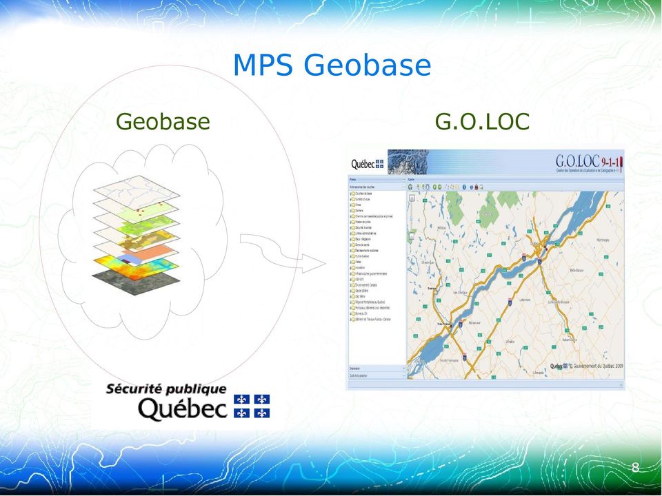
8 MPS Geobase Geobase G.O.LOC 8
9 Objective: MPS Geobase Provide a uniform geobase to all stakeholders 300+ data layers (imagery and vectors) 1.5 TB Data sources: Government Cities, Municipalities Health Private companies (e.g. utilities) OpenStreetMap 9

10 MSP Geobase TileCache (WMS-C/WMTS) OGC WMS GDAL/OGR PostGIS 10

11 OGC WMS Protocol Portrayal Service Returns map images for a given request: LAYERS: name(s) of layer(s) to draw FORMAT: GIF, PNG, JPEG,... WIDTH, HEIGHT: image size BBOX: geospatial extent CRS: coordinate system STYLE: optional, rendering style Does not transport thew raw data VERY widely supported 11

12 OGC WMS Benefits WMS Data Services can be reused by partner organizations in their own application Partner organizations can make their own data available to MPS via WMS No copies: data is always fresh from the source WMS is Portrayal only: raw data not exposed, solves some licensing and political headaches 12

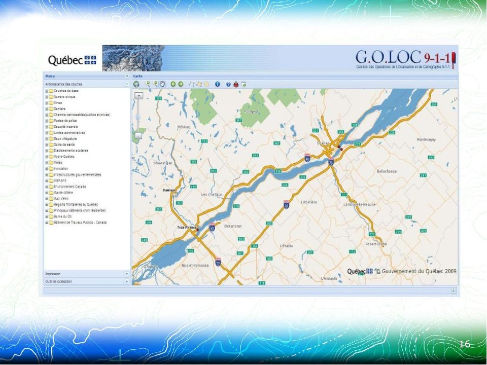
13 G.O.LOC Portal Geobase G.O.LOC 13

14 G.O.LOC Portal For centers and emergency response people Web based: no software to install Quick and simple to use Provides access to the whole Geobase (WMS) Can also access partner data (WMS) Can easily be customized for specific use cases 14
 Can easily be customized for specific use")
15 G.O.LOC Portal Web application OSGeo technologies: OpenLayers MapFish GeoExt/ExtJS Connects to OGC WMS data sources (internal and external) MPS Geocoding Service Leverages the Adresses Quebec database 15

16 16
17 G.O.LOC portal 8 Partner Organizations Centers unique visits per day ~1000 internal users ~500 external users 17

18 S.A.G. for 911 Centers S.A.G. (Autonomous Geographic Service) 18

19 S.A.G. for 911 Centers 19

20 Autonomous Geographic Service (S.A.G.) Designed for 911 centers and emergency response teams Completely autonomous: All software and data is local Does not rely on any external data source Not vulnerable to: Power failures Internet downtime or slowdown Downtime of an external data provider 20

21 Autonomous Geographic Service (S.A.G.) Includes G.O.LOC and all Geobase layers (WMS) 100% open source software OpenSUSE Linux, Apache MapServer, PostgreSQL/PostGIS, GDAL/OGR OpenLayers, MapFish, GeoExt, etc Can be deployed in local mode to any PC or server in case of emergency 21
22 Saving lives in real life 22
23 Partnership Example Quebec National Institute for Public Health 23
24 Quebec National Institute for Public Health Partnership with MPS for the sharing of Development resources Software components Common source code repository (SVN) Data layers 24
25 Quebec National Institute for Public Health System for Real Time Surveillance of Extreme Meteorological Events Impacts on Public Health First application: Heat Wave Surveillance and Decision System Tested in real life during the July 4-8, 2010 heat wave 25
26 Quebec National Institute for Public Health Inputs: Meteorological data and public warnings Health Data Air Quality Geospatial Data Automated Surveillance System (alerts) Decision System (maps, etc) 26
27 Quebec National Institute for Public Health Software: Web Mapping portal shares several components with G.O.LOC 100% open source Uses OGC Standards 27
28 Quebec National Institute for Public Health System deployed June 1st, 2010 July 4-8, 2010 Heat Wave: July 5: system started reporting alerts Regions started deploying action plan early Statistics show +30% mortality variation In previous episodes (1987 and 1994), the variation was over 100% 28
29 Open Source Software and Open Standards are mature technologies They are used in real life around the world They helped save real lives, at least in Quebec Daniel Morissette, Mapgears 29
Open Source Software and Open Interoperability Standards at EDINA National Datacentre
 Open Source Software and Open Interoperability Standards at EDINA National Datacentre Joe Vernon November 25, 2009 Slide 1 of 18 Overview of Presentation Introducing EDINA national datacentre Our thoughts
Institute of Computational Modeling SB RAS
 Institute of Computational Modeling SB RAS ORGANIZATION OF ACCESS TO OBSERVATIONAL DATA USING WEB SERVICES FOR MONITORING SYSTEMS THE STATE OF THE ENVIRONMENT Kadochnikov Aleksey A. Russia, Krasnoyarsk
UK Location Programme
 Location Information Interoperability Board Data Publisher How To Guide Understand the background to establishing an INSPIRE View Service using GeoServer DOCUMENT CONTROL Change Summary Version Date Author/Editor
Neues vom QGIS Server und QGIS-Webclient
 FOSSGIS 2012 Neues vom QGIS Server und QGIS-Webclient Pirmin Kalberer Sourcepole AG, Pfäffikon SZ www.sourcepole.ch Über Sourcepole > QGIS > Core dev. & Project Steering Commitee > Printing, QGIS Server,
County of Los Angeles. Chief Information Office Preferred Technologies for Geographic Information Systems (GIS) September 2014
 September 2014") County of Los Angeles Chief Information Office Preferred Technologies for Geographic Information Systems (GIS) September 2014 CIO Preferred Technologies for GIS This document lists the preferred Geographic
County of Los Angeles Chief Information Office Preferred Technologies for Geographic Information Systems (GIS) September 2014 CIO Preferred Technologies for GIS This document lists the preferred Geographic
Open Source Geospatial Software. Bob Bruce, P.Eng Mapping and Lands Branch, Manitoba Conservation WWW.HWPS.CA Bob.Bruce@gov.mb.ca
 A Survey of Open Source Geospatial Software Bob Bruce, P.Eng Mapping and Lands Branch, Manitoba Conservation WWW.HWPS.CA Bob.Bruce@gov.mb.ca APEGM PD Breakfast Tuesday, 12 June 2007 access this presentation
Data Visualization Using Web GIS Software
 Data Visualization Using Web GIS Software Tuomas Peltonen Radiation and Nuclear Safety Authority (STUK), Finland NKS NordDSS Workshop, Copenhagen, 1.-2.10.2009 RADIATION AND NUCLEAR SAFETY AUTHORITY Preface
PERFORMANCE TESTING OF WEB MAP SERVICES IN THREE DIMENSIONS X, Y, SCALE
 , DOI: 10.2478/sjce-2013-0005 Dušan CIBULKA PERFORMANCE TESTING OF WEB MAP SERVICES IN THREE DIMENSIONS X, Y, SCALE Abstract Dušan CIBULKA Email: dusan.cibulka@gmail.com, dusan.cibulka@zymestic.sk Research
OSGeo Web Mapping Typification: GeoMajas, Mapbender, MapFish and OpenLayers. Christoph Baudson Arnulf Christl FOSS4G 2010 Barcelona
 OSGeo Web Mapping Typification: GeoMajas, Mapbender, MapFish and OpenLayers Christoph Baudson Arnulf Christl FOSS4G 2010 Barcelona Disclaimer All information contained in this presentation has been compiled
Oklahoma s Open Source Spatial Data Clearinghouse: OKMaps
 Oklahoma s Open Source Spatial Data Clearinghouse: OKMaps Presented by: Mike Sharp State Geographic Information Coordinator Oklahoma Office of Geographic Information MAGIC 2014 Symposium April 28-May1,
Introduction to OSGeo and QGIS
 Introduction to OSGeo and QGIS Arnulf Christl OSGeo President Emeritus ESTGIS Pühajärve, Estonia Arnulf Christl Geospatial Systems Architect OSGeo President Emeritus Director of the metaspatial Institute
Combining Drupal Content Management System with OGC Web Services
 Combining Drupal Content Management System with OGC Web Services By Terefe Hanchiso Sodango (Haramaya University, Ethiopia) Dr. U.D. (Ulanbek) Turdukulov & Drs. B.J. (Barend) Köbben(University of Twente,
Open Source GIS The Future?
 Open Source GIS The Future? Daniel Morissette DM Solutions Group Inc. Open Source Licensing No licensing costs Unlimited rights to: Use the software View and analyse the source Copy, reuse in other systems
Interoperable Solutions in Web-based Mapping
 ISPRS SIPT IGU UCI CIG ACSG Table of contents Table des matières Authors index Index des auteurs Search Recherches Exit Sortir Interoperable Solutions in Web-based Mapping Marta Wojnarowska and Bridget
Green Move Web Viewer: critical issues and implementation
 GIT Geology and Information Technology 8a Riunione del Gruppo di Geologia informatica Sezione della Società Geologica Italiana Chiavenna, 17-19 giugno 2013 Polo Territoriale di Como Laboratorio di Geomatica
Geographic Web Application
 University of L Aquila Department of Electrical and Information Engineering Geographic Web Application Enrico Ippoliti Building complete web applications This section discuss how to build complete web
A Comparison of ArcIMS to MapServer
 A Comparison of ArcIMS to MapServer Brock Anderson Refractions Research www.refractions.net 1 Refractions Research Victoria, BC, Canada Spatial Systems Consulting Open Source Software PostGIS udig / GeoTools
VISUAL INSPECTION OF EO DATA AND PRODUCTS - OVERVIEW
 WMS services from the EUMETSAT real-time Image Gallery Uwe Voges (1), Michael Schick (2), Udo Einspanier (1) (1) con terra GmbH Martin-Luther-King-Weg 24, 48155, Münster, Germany EMail: (U.Voges U.Einspanier)@conterra.de
CLOUD BASED N-DIMENSIONAL WEATHER FORECAST VISUALIZATION TOOL WITH IMAGE ANALYSIS CAPABILITIES
 CLOUD BASED N-DIMENSIONAL WEATHER FORECAST VISUALIZATION TOOL WITH IMAGE ANALYSIS CAPABILITIES M. Laka-Iñurrategi a, I. Alberdi a, K. Alonso b, M. Quartulli a a Vicomteh-IK4, Mikeletegi pasealekua 57,
Enabling embedded maps
 Enabling embedded maps Case: National geoportal of Finland Antti Rainio National Land Survey of Finland Trends: Web Services, Mapping Mashup, Open Source, Open Data Decentralised data s Service interfaces
From Geoportal to Spatial Data Service Platform. Jani Kylmäaho National Land Survey of Finland Development Centre
 From Geoportal to Spatial Data Service Platform Jani Kylmäaho National Land Survey of Finland Development Centre 29.6.2012 Introduction National Land Survey of Finland - 1900 employees Development Centre
The OSGeo Foundation. FOSS4G Korea 2011 Seoul. Professionally leveraging Open Source Geospatial. Arnulf Christl President
 The OSGeo Foundation Professionally leveraging Open Source Geospatial Arnulf Christl President FOSS4G Korea 2011 Seoul Arnulf Christl Works as Geospatial Systems Architect in his company metaspatial. President
Implementation of information system to respond to a nuclear emergency affecting agriculture and food products - Case of Morocco
 Centre National de l énergie des sciences et techniques nucléaires (CNESTEN-Morocco) Implementation of information system to respond to a nuclear emergency affecting agriculture and food products - Case
Geospatially Enabling the World: The Convergence of Geospatial and Architectural and Engineering Design
 Geospatially Enabling the World: The Convergence of Geospatial and Architectural and Engineering Design Geoff Zeiss Director of Technology Autodesk Map Middle East Dubai 2007 1 Overview Geospatial inflection
Adoption of open source GIS in South Africa: some case studies
 Adoption of open source GIS in South Africa: some case studies by Gavin Fleming, Kartoza and OSGeo Abstract A number of companies and government departments in South Africa have adopted or migrated to
Cloud application for water resources modeling. Faculty of Computer Science, University Goce Delcev Shtip, Republic of Macedonia
 Cloud application for water resources modeling Assist. Prof. Dr. Blagoj Delipetrev 1, Assist. Prof. Dr. Marjan Delipetrev 2 1 Faculty of Computer Science, University Goce Delcev Shtip, Republic of Macedonia
Leveraging Big Data Technologies to Support Research in Unstructured Data Analytics
 Leveraging Big Data Technologies to Support Research in Unstructured Data Analytics BY FRANÇOYS LABONTÉ GENERAL MANAGER JUNE 16, 2015 Principal partenaire financier WWW.CRIM.CA ABOUT CRIM Applied research
Introduction to the Mapbender OWS Security Proxy
 Introduction to the Mapbender OWS Security Proxy Arnulf Christl, WhereGroup GmbH & Co. KG, Bonn, Germany 1/16 Agenda 1 Introduction to the Architecture OWS from Bottom Up with the OSGeo SDI Software Stack
Standardized data sharing through an open-source Spatial Data Infrastructure: the Afromaison project
 Standardized data sharing through an open-source Spatial Data Infrastructure: the Afromaison project Yaniss Guigoz - University of Geneva/GRID-Geneva 1 EcoARM2ERA and AFROMAISON Why Afromaison in this
CURSO Inspire INSPIRE. SPEAKER: Pablo Echamendi Lorente. JEUDI 23/ THURSDAY 23 rd W S V : G E O S P A T I A L D A T A A C C E S S
 CURSO Inspire JEUDI 23/ THURSDAY 23 rd SPEAKER: Pablo Echamendi Lorente WS 5 SCHEDULE WMS OVERVIEW ACTIONS OGC SPECIFICATIONS OTHER SERVICES OVERVIEW proposal: Member States shall establish and operate
DataTube: web services voor data
 DataTube: web services voor data Gerben de Boer Onno van de Akker Gerrit Hendriksen Deltares, Matroos Deltares, FEWS Deltares, NHI FEWS & Matroos: database > viewers VIEWER client 3 rd party viewer Matroos
Standards based spatial data management, GIS and web mapping. Spatial data management, analysis & sharing the free & easy way!
 or Spatial data management, analysis & sharing the free & easy way! Premise: Traditional GIS is inherently flawed, especially when it comes to many fisheries/maritime datasets Premise: Traditional GIS
ishare in the Cloud Service Definition v5.0
 Service Definition v5.0 An overview of ishare in the Cloud ishare is an end to end Enterprise GIS for public sector comprising a spatial data warehouse, rich functionality browser based GIS including editing
Choosing the right GIS framework for an informed Enterprise Web GIS Solution
 13 ANNUAL INTERNATIONAL CONFERENCE AND EXHIBITION ON GEOSPATIAL INFORMATION TECHNOLOGY AND APPLICATIONS Epicentre; Gurgaon, India; 19-21 January, 2010 Choosing the right GIS framework for an informed Enterprise
Web Mapping and Geospatial Web: An Introductory Course for Geographers and Geoscientists
 Web Mapping and Geospatial Web: An Introductory Course for Geographers and Geoscientists Emmanuel Stefanakis Department of Geodesy and Geomatics Engineering University of New Brunswick Fredericton, NB,
Comparison of Open Source Virtual Globes
 FOSS4G 2010 Comparison of Open Source Virtual Globes Mathias Walker Pirmin Kalberer Sourcepole AG, Bad Ragaz www.sourcepole.ch About Sourcepole GIS-Knoppix: first GIS live-cd QGIS Core developer QGIS Mapserver
Web-based public participation GIS application - a case study on flood emergency management
 Student thesis series INES nr 263 Web-based public participation GIS application - a case study on flood emergency management Peng Wang 2012 Department of Physical Geography and Ecosystem Science Lund
GeoMedia Smart Client
 GEOSPATIAL GeoMedia Smart Client Dynamically Jumpstart Your GIS GeoMedia Smart Client Is your geographic information system (GIS) at a gridlock, stuck in a department, limited to a few, contained and
WP6. e-soter Web Services: Status and Way Ahead to a Global Soil Information Service Yusuf YIGINI EU Joint Research Centre
 e-soter Regional pilot platform as EU contribution to a Global Soil Observing System WP6. e-soter Web Services: Status and Way Ahead to a Global Soil Information Service Yusuf YIGINI EU Joint Research
SUMMER SCHOOL ON ADVANCES IN GIS
 SUMMER SCHOOL ON ADVANCES IN GIS Six Workshops Overview The workshop sequence at the UMD Center for Geospatial Information Science is designed to provide a comprehensive overview of current state-of-the-art
FreeGIS.net, INSPIRE, Open Source Software and OGC standards
 FreeGIS.net, INSPIRE, Open Source Software and OGC standards Workshop: How Open Source / Free Software and Open Standards complement each other in an SDI environment SFScon 13 Free Software Conference
Treading Into Open Source GIS
 Treading Into Open Source GIS 49th Annual Alaska Surveying & Mapping Conference February 18 th, 2015 David Howes, Ph.D. - David Howes, LLC dhowes.com Jason Pardy - NewfoundGEO Consulting newfoundgeo.com
Vector tiles for the Swiss Federal Geoportal
 Vector tiles for the Swiss Federal Geoportal Ingensand Jens, Marion Nappez1, Cédric Moullet, Loïc Gasser2,Sarah Composto1 1 GIS Lab, University of Applied Sciences Western Switzerland. Route de Cheseaux
GeoPackage, The Shapefile Of The Future
 FOSS4G 2013 GeoPackage, The Shapefile Of The Future @PirminKalberer Sourcepole AG, Switzerland www.sourcepole.com About Sourcepole > QGIS > Core dev. & Project Steering Commitee > QGIS Server, Printing,
GEO 425, Spring 2012 LAB 3: Introduction to Web Map Services
 GEO 425, Spring 2012 LAB 3: Introduction to Web Map Services Objectives: If you have your own web server, it's great to be able to host your own geospatial data. That data can then be accessed through
Web 3D Service (W3DS) in Geoserver
 in Geoserver") Jorge Gustavo Rocha jgr@di.uminho.pt Nuno Carvalho Oliveira nmco51845@gmail.com VI Jornadas SIG Libre, Girona, March 23, 2012 1 Motivation and Introduction 2 3 4 5 Motivation Motivation and Introduction
Jorge Gustavo Rocha jgr@di.uminho.pt Nuno Carvalho Oliveira nmco51845@gmail.com VI Jornadas SIG Libre, Girona, March 23, 2012 1 Motivation and Introduction 2 3 4 5 Motivation Motivation and Introduction
WEB MAPPING WITH DRUPAL Ranel O. Padon
 WEB MAPPING WITH DRUPAL Ranel O. Padon WHY WEB? connectivity & interaction WHY CMS? WHY CMS? WHY CMS? WHY CMS? WHY CMS? WHY PHP? used by almost 30 Million websites around the world. http://trends.builtwith.com/framework/php
Design Requirements for an AJAX and Web-Service Based Generic Internet GIS Client
 11th AGILE International Conference on Geographic Information Science 2008 Page 1 of 6 Design Requirements for an AJAX and Web-Service Based Generic Internet GIS Client Edward Nash 1, Peter Korduan 1,
DEVELOPMENT OF REAL-TIME TRACKING & LOG MANAGEMENT SYSTEM USING FREE AND OPEN SOURCE SOFTWARE
 DEVELOPMENT OF REAL-TIME TRACKING & LOG MANAGEMENT SYSTEM USING FREE AND OPEN SOURCE SOFTWARE Daisuke Yoshida and Venkatesh Raghavan Graduate School for Creative Cities, Osaka City University 3-3-138 Sugimoto,
Correspondence can be sent to: GeoConnections Natural Resources Canada 615 Booth Street Ottawa, Ontario K1A 0E9
 Quick Guide for CGDI Service Compliance Testing and Performance Optimization May 12, 2009 Correspondence can be sent to: GeoConnections Natural Resources Canada 615 Booth Street Ottawa, Ontario K1A 0E9
W H I T E P A P E R. Security & Defense Solutions Intelligent Convergence with EdgeFrontier
 W H I T E P A P E R Security & Defense Solutions Intelligent Convergence with EdgeFrontier Contents 1. Introduction... 2 2. The Need for Intelligent Convergence... 3 2.1 Security Convergence with EdgeFrontier...
DISMAR implementing an OpenGIS compliant Marine Information Management System
 DISMAR implementing an OpenGIS compliant Marine Information Management System Éamonn Ó T uama, Coastal & Marine Resources Centre, ERI, University College Cork. DISMAR DISMAR (Data Integration System for
G-Cloud Service Definition Cadcorp Web Map Layers
 G-Cloud Service Definition Cadcorp Web Map Layers Ref: RM1557/iii Government Procurement Services G-Cloud III Contents 1. Introduction... 3 2. Service Overview... 4 2.1 Web Map Layers... 4 2.2 Initial
SDI National to Global: perspectives from the UK academic sector
 SDI National to Global: perspectives from the UK academic sector Conor G. Smyth, PhD, FRGS, CGeog. (GIS) conor.smyth@ed.ac.uk EDINA, The University of Edinburgh, Scotland Keywords: academic SDI; geospatial
Merging geo technology stacks: building hybrid systems. Michael Terner, Executive Vice President May, 2015
 Merging geo technology stacks: building hybrid systems Michael Terner, Executive Vice President May, 2015 Terner s definition of hybrid system A solution that involves more than one technology component,
GIS AS A DECISION SUPPORT FOR SUPPLY CHAIN MANAGEMENT
 Paper Reference No.: PN-253 GIS AS A DECISION SUPPORT FOR SUPPLY CHAIN MANAGEMENT Sanjay Kumar 1 and Suneeta Agrawal 2 1. M. Tech. (GIS & Remote Sensing); GIS Cell; MNNIT, Allahabad, India (E-mail: saj.mnnit@gmail.com)
Visualize your World. Democratization i of Geographic Data
 Visualize your World Democratization i of Geographic Data Session Agenda Google GEO Solutions - More than just a Map Enabling our Government Customers- Examples Summary & Invite to Learn More About Google
How To Use The Alabama Data Portal
 113 The Alabama Metadata Portal: http://portal.gsa.state.al.us By Philip T. Patterson Geological Survey of Alabama 420 Hackberry Lane P.O. Box 869999 Tuscaloosa, AL 35468-6999 Telephone: (205) 247-3611
From Business Intelligence to Location Intelligence with the Lily Library
 From Business Intelligence to Location Intelligence with the Lily Library Matteo Golfarelli Stefano Rizzi Marco Mantovani Federico Ravaldi Agenda Location Intelligence State of the art Lily Features Architecture
INTEROPERABLE IMAGE DATA ACCESS THROUGH ARCGIS SERVER
 INTEROPERABLE IMAGE DATA ACCESS THROUGH ARCGIS SERVER Qian Liu Environmental Systems Research Institute 380 New York Street Redlands, CA92373, U.S.A - qliu@esri.com KEY WORDS: OGC, Standard, Interoperability,
The ORIENTGATE data platform
 Seminar on Proposed and Revised set of indicators June 4-5, 2014 - Belgrade (Serbia) The ORIENTGATE data platform WP2, Action 2.4 Alessandra Nuzzo, Sandro Fiore, Giovanni Aloisio Scientific Computing and
AUTOMATING MAPPING PRODUCTION FOR THE ENTERPRISE: FROM CONTRACT TO DELIVERY
 AUTOMATING MAPPING PRODUCTION FOR THE ENTERPRISE: FROM CONTRACT TO DELIVERY R. Uebbing, C. Xie, B. Beshah, J. Welter North West Geomatics Ltd., Suite 212, 5438-11 th Street NE, Calgary, Alberta, T2E 7E9,
Open Source Visualisation with ADAGUC Web Map Services
 Open Source Visualisation with ADAGUC Web Map Services Maarten Plieger Ernst de Vreede John van de Vegte, Wim Som de Cerff, Raymond Sluiter, Ian van der Neut, Jan Willem Noteboom 1 ADAGUC project Cooperative
OSM GB. Introduction. Users Requirements. Abstract OSM GB
 OSM GB Using Open Source Geospatial Tools to Create OSM Web Services for Great Britain by Amir Pourabdollah University of Nottingham, United Kingdom. amir.pourabdollah@nottingham.ac.uk Abstract A use case
AN OPENGIS WEB MAP SERVER FOR THE ESA MULTI-MISSION CATALOGUE
 AN OPENGIS WEB MAP SERVER FOR THE ESA MULTI-MISSION CATALOGUE T. Westin a, *, C. Caspar b, L. Edgardh a, L. Schylberg c a Spacemetric AB, Tingsv 19, 19161 Sollentuna, Sweden - tw@spacemetric.se b ESA Esrin,
Big Data Volume & velocity data management with ERDAS APOLLO. Alain Kabamba Hexagon Geospatial
 Big Data Volume & velocity data management with ERDAS APOLLO Alain Kabamba Hexagon Geospatial Intergraph is Part of the Hexagon Family Hexagon is dedicated to delivering actionable information through
A WEB GIS FOR WETLANDS OF KERALA USING OPEN SOURCE GEOSPATIAL SOFTWARE. Santosh Gaikwad* and S Narendra Prasad**
 A WEB GIS FOR WETLANDS OF KERALA USING OPEN SOURCE GEOSPATIAL SOFTWARE Santosh Gaikwad* and S Narendra Prasad** Salim Ali Centre for Ornithology and Natural History Deccan Regional Station, Hyderabad *gaikwadss@rediffmail.com
INSPIRE in practice: Experiences with INSPIRE data and services
 INSPIRE in practice: Experiences with INSPIRE data and services Peter Parslow Principal Geographic Information Architect June 2014: ISO TC211 Standards in Practice workshop What s INSPIRE? European Commission
DEVELOPING WEB-BASED MAPPING SERVICES FOR PUBLIC HEALTH APPLICATIONS
 DEVELOPING WEB-BASED MAPPING SERVICES FOR PUBLIC HEALTH APPLICATIONS Amelia M. Budge a *, Karl K. Benedict a, and William Hudspeth a a EDAC, University of New Mexico, Albuquerque, NM 87131-0001, USA-(abudge,
WP 3. Elaboration database Architecture Features (Software Architecture Document)
") Architecture Features (Software Architecture Document) o Best in class solution, using EC recommendations for IT in this field o Implementation based on free open source o Based on OGC standards, high
Architecture Features (Software Architecture Document) o Best in class solution, using EC recommendations for IT in this field o Implementation based on free open source o Based on OGC standards, high
Big Data, Cloud Computing, Spatial Databases Steven Hagan Vice President Server Technologies
 Big Data, Cloud Computing, Spatial Databases Steven Hagan Vice President Server Technologies Big Data: Global Digital Data Growth Growing leaps and bounds by 40+% Year over Year! 2009 =.8 Zetabytes =.08
Open Source Geospatial: An Alternative Business Model for Municipal Governments
 Open Source Geospatial: An Alternative Business Model for Municipal Governments Dave McIlhagga DM Solutions Group 30 Rosemount Ave. Suite 200 Ottawa, Ontario, Canada K1Y 1P4 dmcilhagga@dmsolutions.ca Geoff
Zorba Asset Tracking Solution
 Asset Tracking Solution State-of-the art fleet management and vehicle tracking solution to increase your productivity. Affordable installation and operating costs Easy to install and operate User friendly
Statusreport MapServer
 Statusreport MapServer Version 7.0 Wir erschließen das räumliche Potenzial Ihrer Daten. Seit 1997 GIS- und WebGIS-Projekte mit freier Software Entwicklung Anpassung Support Schulungen Wir erschließen das
Institute of Natural Resources Departament of General Geology and Land use planning Work with a MAPS
 Institute of Natural Resources Departament of General Geology and Land use planning Work with a MAPS Lecturers: Berchuk V.Y. Gutareva N.Y. Contents: 1. Qgis; 2. General information; 3. Qgis desktop; 4.
Project Title: Judicial Branch Enterprise Document Management System RFP Number: FIN122210CK Appendix D Technical Features List
 FEAT891 Medium Recoverable using backup The solution shall be recoverable from backup storage media storage media. FEAT893 Desired Medium Support Load Sharing High Availability The solution should utilize
Portal for ArcGIS. Satish Sankaran Robert Kircher
 Portal for ArcGIS Satish Sankaran Robert Kircher ArcGIS A Complete GIS Data Management Planning & Analysis Field Mobility Operational Awareness Constituent Engagement End to End Integration Collect, Organize,
 Development tools to create Web-GIS applications DbMAP ASJ the best solution to easily publish GIS data from existing spatial databases and distributed GIS data sources Easily designs, produces, and publishes
GEOENGINE MSc in Geomatics Engineering, Master Thesis Gina Campuzano
 Master Thesis Gina CAMPUZANO Gina Campuzano Development of a GIS web application as a tool for learning of environmental protection -Comparison between MapServer and GeoServer constructing a tool for not
EUMETSAT EO Portal. End User Image Access using OGC WMS/WCS services. EUM/OPS/VWG/10/0095 Issue <1> <14/01/2010> Slide: 1
 EUMETSAT EO Portal End User Image Access using OGC WMS/WCS services Slide: 1 Overview Introduction: status of data access and visualization EUMETSAT datasets Architecture Web Map Service implementation
ARCHITECTURE OF INTEGRATED GIS AND GPS FOR VEHICLE MONITORING
 1 st Logistics International Conference Belgrade, Serbia 28-30 November 2013 ARCHITECTURE OF INTEGRATED GIS AND GPS FOR VEHICLE MONITORING Adela B. Crnišanin * State University of Novi Pazar, Department
MD imap 2.0 THE NEXT GENERATION OF MARYLAND S ENTERPRISE GIS. Esri MUG Conference Baltimore, MD December 3, 2014 http://imap.maryland.
 THE NEXT GENERATION OF MARYLAND S ENTERPRISE GIS MD imap 2.0 Matt Sokol, GISP Senior GIS Analyst Maryland Department of Information Technology Geographic Information Office Julia Fischer, GISP Senior GIS
Quality Assessment for Geographic Web Services. Pedro Medeiros (1)
") Quality Assessment for Geographic Web Services Pedro Medeiros (1) (1) IST / INESC-ID, Av. Prof. Dr. Aníbal Cavaco Silva, 2744-016 Porto Salvo, pmelo.medeiros@gmail.com Abstract Being able to assess the
Quality Assessment for Geographic Web Services Pedro Medeiros (1) (1) IST / INESC-ID, Av. Prof. Dr. Aníbal Cavaco Silva, 2744-016 Porto Salvo, pmelo.medeiros@gmail.com Abstract Being able to assess the
Geographic Information Systems Research Center, Feng Chia University (GIS.FCU)
") Geographic Information Systems Research Center, Feng Chia University (GIS.FCU) No. 100 Wenhwa Rd., Seatwen District, Taichung, 40724 Taiwan Telephone: +886-4-24516669 Facsimile: +886-4-24519278 The Development
Geographic Information Systems Research Center, Feng Chia University (GIS.FCU) No. 100 Wenhwa Rd., Seatwen District, Taichung, 40724 Taiwan Telephone: +886-4-24516669 Facsimile: +886-4-24519278 The Development
URISA EXEMPLARY SYSTEMS IN GOVERNMENT AWARD (ESIG) The Department of Homeland Security Geospatial Information Infrastructure (GII)
 The Department of Homeland Security Geospatial Information Infrastructure (GII)") May 10, 2013 Award Submittal URISA EXEMPLARY SYSTEMS IN GOVERNMENT AWARD (ESIG) The Department of Homeland Security Geospatial Information Infrastructure (GII) Submitted by: David Alexander, Director Geospatial
May 10, 2013 Award Submittal URISA EXEMPLARY SYSTEMS IN GOVERNMENT AWARD (ESIG) The Department of Homeland Security Geospatial Information Infrastructure (GII) Submitted by: David Alexander, Director Geospatial
Open Source Software Communities - Lessons Learnt
 1 Open Source Software Communities - Lessons Learnt Imed Hammouda, adjunct professor Alexander Lokhman, researcher Tampere University of Technology 25.2.2011 Open Source vs. Free Software 2 Free software
Centre for EcologicalNoosphere Studies NAS RA CENS
 SCOPES 2009-2012 Scientific Co-operation between Eastern Europe and Switzerland Accessing Armenian Environmental data through CENS Spatial Data Infrastructure Centre for EcologicalNoosphere Studies NAS
GeoServer, The Open Source Solution for the interoperable management of geospatial data
 GeoServer, The Open Source Solution for the interoperable management of geospatial data Ing. Andrea Aime, GeoSolutions Ing. Simone Giannecchini, GeoSolutions Founded in Italy in late 2006 Expertise GeoSolutions
FME 2007 Release Giving Raster the Vector Treatment. By Mary Jo Wagner
 FME 2007 Release Giving Raster the Vector Treatment By Mary Jo Wagner Giving Raster the Vector Treatment By Mary Jo Wagner Spatial extract, transform and load (ETL) tools such as Safe Software s FME have
Integrating AJAX Approach into GIS Visualization Web Services
 Integrating AJAX Approach into GIS Visualization Web Services Ahmet Sayar 1, 2, *, Marlon Pierce 1 1, 2, 3, 4 and Geoffrey Fox 1 Community Grids Lab, Indiana University, Bloomington, Indiana, 47404, USA
GOSIC NEXRAD NIDIS NOMADS
 NOAA National Climatic Data Center GOSIC NEXRAD NIDIS NOMADS Christina Lief NOAA/NESDIS/NCDC GOSIC Program Manager NOAA/NESDIS/NCDC Asheville, NC 28801 GEOSS AIP Phase 2 Workshop September 25-26, 2008
Scientific Data Management and Dissemination
 Federal GIS Conference February 9 10, 2015 Washington, DC Scientific Data Management and Dissemination John Fry Solution Engineer, Esri jfry@esri.com Agenda Background of Scientific Data Management through
Enterprise GIS Solutions to GIS Data Dissemination
 Enterprise GIS Solutions to GIS Data Dissemination ESRI International User Conference July 13 17, 2009 Wendy M. Turner Senior GIS Engineer & Program Manager Freedom Consulting Group, LLC Building the Enterprise
Development of a prototype for Spatial Decision Support System in risk reduction based on open-source web-based platform
 Development of a prototype for Spatial Decision Support System in risk reduction based on open-source web-based platform Roya Olyazadeh, Zar Chi Aye, Michel Jaboyedoff Centre de recherches en environnement
Secure your GIS. Protecting GIS applications suites. camptocamp / 9. septembre 2010 / www.camptocamp.com / info@camptocamp.com
 Secure your GIS Protecting GIS applications suites camptocamp / 9. septembre 2010 / www.camptocamp.com / info@camptocamp.com Outline - Camptocamp SA - Introduction Green field Heterogenous FOSS applications
Data interchange between Web client based task controllers and management information systems using ISO and OGC standards
 Data interchange between Web client based task controllers and management information systems using ISO and OGC standards Michael Nørremark 1*, Ole Jørgensen 1, Jens Bligaard 2 and Claus G. Sørensen 1
DEVELOPMENT AND COMPARISON OF OPEN SOURCE BASED WEB GIS FRAMEWORKS ON WAMP AND APACHE TOMCAT WEB SERVERS
 DEVELOPMENT AND COMPARISON OF OPEN SOURCE BASED WEB GIS FRAMEWORKS ON WAMP AND APACHE TOMCAT WEB SERVERS Sonam Agrawal a, Rajan Dev Gupta b a GIS Cell, Motilal Nehru National Institute of Technology, Allahabad-211004,
Developing of A GIS Based Enviromental Monitoring System with Open Source Softwares
 L. Kottyán, G. Nagy, A. Szepes Developing of A GIS Based Enviromental Monitoring System with Open Source Softwares Developing of A GIS Based Enviromental Monitoring System with Open Source Softwares László
Caching techniques for high-performance Web Map Services
 Caching techniques for high-performance Web Map Services Alexander J. Loechel University of the Bundeswehr Munich, Germany Alexander.Loechel@unibw.de Stephan Schmid University of the Bundeswehr Munich,
Big Data Platform (BDP) and Cyber Situational Awareness Analytic Capabilities (CSAAC)
 and Cyber Situational Awareness Analytic Capabilities (CSAAC)") Big Data Platform (BDP) and Cyber Situational Awareness Analytic Capabilities (CSAAC) Daniel V. Bart DISA Infrastructure Development Cyber Situational Awareness and Analytics 22 April 2016 Presentation
Big Data Platform (BDP) and Cyber Situational Awareness Analytic Capabilities (CSAAC) Daniel V. Bart DISA Infrastructure Development Cyber Situational Awareness and Analytics 22 April 2016 Presentation