GeoNetwork, The Open Source Solution for the interoperable management of geospatial metadata
|
|
|
- Evangeline Bruce
- 9 years ago
- Views:
Transcription

1 GeoNetwork, The Open Source Solution for the interoperable management of geospatial metadata Ing. Simone Giannecchini, GeoSolutions Ing. Emanuele Tajariol, GeoSolutions
2 Outline GeoNetwork Introduction History Software Features Standards Architecture User Interface INSPIRE RNDT
3 (GeoSpatial) Catalog GeoNetwork Registry of Metadata Repository Enterprise Search Appliance GeoPortal SDI entry point Information Broker Metadata Editor Standards Based Implemented with Java Enterprise technologies
4 Java Enterprise Technologies Apache Lucene for speed light search Support for different backends MYSQL, Oracle, Postgresql, etc.. XSL Templates for flexible presentation XML Schema Metadata Validation and Editing Support for Enterprise Security LDAP Shibboleth
 INSPIRE")
5 Standards ISO TC : : : : : /Z39.50 OGC CSW (ISO Profile) INSPIRE Discovery Service Others FGDC OpenSearch Geo RSS/GeoRSS WebDAV OAI-PMH Dublin Core
6 GeoNetwork: features (1) Search capabilities to access local and distributed geospatial catalogues Up- and downloading of data, graphics, documents, pdf files and any other content type An interactive Web Map Viewer to combine Web Map Services from local and distributed servers around the world On-line editing of metadata with a powerful template system XSD schema and schematron validation of metadata Native support for international metadata standards Multilingual metadata support for the ISO19115/19119/19110
7 GeoNetwork: features (2) INSPIRE advanced search option Data and metadata export/import procedures Scheduled harvesting and synchronization of metadata between distributed catalogues (GeoNetwork, CSW, Z39.50, OGC WxS, WebDav, Thredds, OAI-PMH) Support CSW ISO Profile, OAI-PMH, Z39.50 protocols Administration of groups and users through Web interface Multi-lingual user interface Data updates dissemination via RSS news feeds and as GeoRSS
8 Standards Metadata ISO19115:2003, ISO19119:2005, ISO19110:2005, ISO19139:2007 FGDC, Dublin Core Export/Import RSS & GeoRSS newsfeeds XML + XSL Catalogue interfaces OGC CSW ISO Profile OAI-PMH Z39.50 Geo-OpenSearch GeoRSS WebDAV Web Mapping Client OGC standards for WMS, WMC Web Map Server (through GeoServer) WMS, WFS, WFS-t, WCS, KML COMMON LANGUAGES EXCHANGE FORMATS CATALOGUES/ WEB SERVICES

9 Architecture Frontend - UI Search Edit View map Lucene index Metadata registry Spatial data repository GeoServer

 Can work in federation Multilingualism")
10 Manage, Publish and Search collections of metadata about Data, Services and related information ISO Metadata about Data ISO Metadata about Services Enterprise Unique entry point Act as a Broker (SOA) Can work in federation Multilingualism Registry
11 Repository GeoNetwork can be used as a repository for the data it describes Authorization on data are independent from authorization on related metadata Easy-to-use editor controls to upload data and set automatically the onlineresource URL
12 Registry - Federation Multiple Registries for Multiple Enterprise Clouds Different data/services Different Organizations Federation reduces complexity Available Paradigms Harvesting Synchronized Local Copy of remote Metadata Remote Search Federating node as NoCache proxy for queries GeoNetwork supports both
13 GeoNetwork OGC Portal Reference Architecture
14 Architecture Desktop and server versions running on any platform Windows, Linux, Mac OSX Java Application using XML+XSL Lucene (Apache Project for XML file indexing) Jeeves (Open Source project for XML DB interface) GeoNetwork McKoi (Desktop), MySQL, Oracle Java Application Template XSL Jetty (Desktop), Tomcat DB Indexing Lucene Jeeves (DB XML)


15 Metadata harvesting Multiple paths to same source Loops GeoNetwork Nodes Hierarchical harvesting
16 Enterprise GeoPortal User Friendly Search/View GeoPortal Customizable Presentation Search Forms Results Presentation Based on XSL templates Embedding in third party sites Integrate with A&A layers Different views for different roles Metadata Profiling
17 Enterprise GeoPortal Metadata Profiling Authentication Internal user management for smaller deploys LDAP integration Shibboleth integration (federated SSO) Authorization User groups (grants on metadata) - customizable User profiles (grants on operations) - fixed Metadata access authorization is fine grained at group level
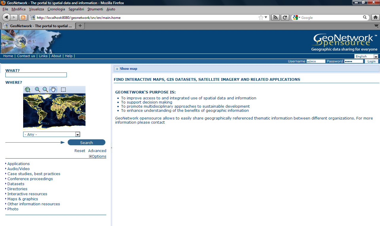
18 User interface/home page
19 Web user interface/search Simple/local search Advanced search

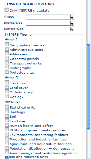
20 Web user interface/search Inspire-based search options
21 Web user interface/search results

22 Web user interface/metadata Display Metadata summary Metadata details
23 Web user interface/search results
24 Web user interface/search results
25 Web user interface/search results

26 Embedded Web Map Client Map viewer opened Web user interface/web map viewer Layer tree section Map toolbar Add data layer (layers toolbar)

27 Google Earth Support View in Google Earth

28 Administration section Administration Login/Logout Add new metadata

29 Metadata editor/default View
30 Metadata editor/xml View Full ISO metadata support ISO19115:2003 / ISO19139:2007

31 Metadata editor/categories assignment
32 Metadata editor/data upload

33 Metadata editor/privileges assignment
34 Harvesting management
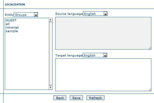
35 Localization Support

36 Metadata Editor Terms and Rules from ISO and Encoding in 19139, FGDC and Dublin Core Intuitive Web-Based Editor with Validation Identification Section Distribution Section Reference System Section Data Quality Section Metadata Section Highly Customizable Presentation Validation
 Additional Metadata Linking (dataset/service, parent/child, feature catalog/dataset metadata) Role assignment for presentation profiling Multilingual Support Batch")
37 Metadata Editor Additional capabilities Extensible Templates set Visual Validation Extensive online resource management (WMS, File download, etc..) Additional Metadata Linking (dataset/service, parent/child, feature catalog/dataset metadata) Role assignment for presentation profiling Multilingual Support Batch Import/Insert from XML
38 INSPIRE support in GeoNetwork Editing view that underlines INSPIRE required elements Easy check and insertion of INSPIRE required elements Schematron rules to check for INSPIRE conformance Search using INSPIRE codelists Extended CSW queryables fields to match INSPIRE requirements
39 RNDT: about RNDT («Repertorio Nazionale dei Dati Territoriali») is the Italian national metadata catalog - instituted in 2005 and managed by DigitPA - whose purpose is to facilitate the dissemination of the data of general interest, available in the public administration agencies at different levels. RNDT is based on ISO19115, and standards. Conformance to the RNDT metadata standard should ensure conformance to INSPIRE guidelines
40 RNDT support in GeoNetwork GeoSolutions first work with RNDT was with a GeoNetwork customization for CSI Piemonte. Issues: Some RNDT interpretations of ISO19139 differ from GeoNetwork standard implementation. Some constraints in RNDT are looser than ISO19139

41 RNDT support in GeoNetwork Search on PSR thesaurus
42 GeoNetwork 2.8 What s new Metadata versioning Subtemplates GeoServer publishing integration Pluggable metadata schemas Improved database connection pooling Virtual CSW endpoints


43 GeoNetwork 2.10 What s new Redesigned User Interface Metadata profiles plugin support New Admin UI

44 Admin UI GeoNetwork 2.10

45 System Status GeoNetwork 2.10
46 Search Statistics GeoNetwork 2.10
47 Content Statistics GeoNetwork 2.10
48 GeoNetwork 2.10 Harvester Configuration
49 A location to collect, develop and maintain metadata profiles Easy collaboration Github repository Versioning Permissive licensing to allow incorporation in open source and proprietary software Perfect fit for RNDT


50 Real World Use Cases: City of FIorence OpenData Portal

51 Real World Use Cases: LaMMa Consortium

52 Real World Use Cases: County of Bozen

53 Real World Use Cases: Danish Ministry of the Environment


54 Real World Use Cases

55 Real World Use Cases


56 The End Questions?
GeoNetwork, The Open Source Solution for the interoperable management of geospatial metadata
 GeoNetwork, The Open Source Solution for the interoperable management of geospatial metadata Ing. Emanuele Tajariol, GeoSolutions Ing. Simone Giannecchini, GeoSolutions GeoSolutions GeoSolutions GeoNetwork
GeoNetwork and ESRI GIS Portal Toolkit Comparison
 GeoNetwork and Comparison The following software are being evaluated for the GeoSUR project for the implementation of GIS portal application for the South American region. The information collected for
An ESRI White Paper October 2009 ESRI Geoportal Technology
 An ESRI White Paper October 2009 ESRI Geoportal Technology ESRI 380 New York St., Redlands, CA 92373-8100 USA TEL 909-793-2853 FAX 909-793-5953 E-MAIL [email protected] WEB www.esri.com Copyright 2009 ESRI
Workshop Advanced GeoNetwork
 Workshop Advanced GeoNetwork Jose Garcia Heikki Doeleman OSGIS Nottingham 2012 Table of contents Introduction A horizontally scaled, load-balanced cluster External security system Setup PC Configuration
The ORIENTGATE data platform
 Seminar on Proposed and Revised set of indicators June 4-5, 2014 - Belgrade (Serbia) The ORIENTGATE data platform WP2, Action 2.4 Alessandra Nuzzo, Sandro Fiore, Giovanni Aloisio Scientific Computing and
INSPIRE Dashboard. Technical scenario
 INSPIRE Dashboard Technical scenario Technical scenarios #1 : GeoNetwork catalogue (include CSW harvester) + custom dashboard #2 : SOLR + Banana dashboard + CSW harvester #3 : EU GeoPortal +? #4 :? + EEA
Mastering Advanced GeoNetwork
 Mastering Advanced GeoNetwork Heikki Doeleman & Jose García http://geocat.net Contents Introduction Setup GeoNetwork with Tomcat/Apache Configure Postgres database GeoNetwork advanced configuration Objectives
Francesco Tortorelli
 Francesco Tortorelli Joint CEN/TC 287 and OGC Workshop Bringing GI Standards-making bodies together Frascati (Rome), 30 September 2013 (AgID) AgID (previously CNIPA and DigitPA) is a government agency
Enabling embedded maps
 Enabling embedded maps Case: National geoportal of Finland Antti Rainio National Land Survey of Finland Trends: Web Services, Mapping Mashup, Open Source, Open Data Decentralised data s Service interfaces
GetLOD - Linked Open Data and Spatial Data Infrastructures
 GetLOD - Linked Open Data and Spatial Data Infrastructures W3C Linked Open Data LOD2014 Roma, 20-21 February 2014 Stefano Pezzi, Massimo Zotti, Giovanni Ciardi, Massimo Fustini Agenda Context Geoportal
EXPLORING AND SHARING GEOSPATIAL INFORMATION THROUGH MYGDI EXPLORER
 EXPLORING AND SHARING GEOSPATIAL INFORMATION THROUGH MYGDI EXPLORER Subashini Panchanathan Malaysian Centre For Geospatial Data Infrastructure ( MaCGDI ) Ministry of National Resources and Environment
An Esri White Paper June 2011 ArcGIS for INSPIRE
 An Esri White Paper June 2011 ArcGIS for INSPIRE Esri, 380 New York St., Redlands, CA 92373-8100 USA TEL 909-793-2853 FAX 909-793-5953 E-MAIL [email protected] WEB esri.com Copyright 2011 Esri All rights reserved.
GeoNetwork User Manual
 GeoNetwork User Manual Release 2.10.4-0 GeoNetwork July 06, 2015 Contents 1 Preface 3 1.1 About this Project..................................... 3 1.2 License Information....................................
Introduction to the Mapbender OWS Security Proxy
 Introduction to the Mapbender OWS Security Proxy Arnulf Christl, WhereGroup GmbH & Co. KG, Bonn, Germany 1/16 Agenda 1 Introduction to the Architecture OWS from Bottom Up with the OSGeo SDI Software Stack
Standardized data sharing through an open-source Spatial Data Infrastructure: the Afromaison project
 Standardized data sharing through an open-source Spatial Data Infrastructure: the Afromaison project Yaniss Guigoz - University of Geneva/GRID-Geneva 1 EcoARM2ERA and AFROMAISON Why Afromaison in this
Metadata for Data Discovery: The NERC Data Catalogue Service. Steve Donegan
 Metadata for Data Discovery: The NERC Data Catalogue Service Steve Donegan Introduction NERC, Science and Data Centres NERC Discovery Metadata The Data Catalogue Service NERC Data Services Case study:
Enterprise GIS Solutions to GIS Data Dissemination
 Enterprise GIS Solutions to GIS Data Dissemination ESRI International User Conference July 13 17, 2009 Wendy M. Turner Senior GIS Engineer & Program Manager Freedom Consulting Group, LLC Building the Enterprise
From Geoportal to Spatial Data Service Platform. Jani Kylmäaho National Land Survey of Finland Development Centre
 From Geoportal to Spatial Data Service Platform Jani Kylmäaho National Land Survey of Finland Development Centre 29.6.2012 Introduction National Land Survey of Finland - 1900 employees Development Centre
CDI/THREDDS Interoperability: the SeaDataNet developments. P. Mazzetti 1,2, S. Nativi 1,2, 1. CNR-IMAA; 2. PIN-UNIFI
 CDI/THREDDS Interoperability: the SeaDataNet developments P. Mazzetti 1,2, S. Nativi 1,2, 1. CNR-IMAA; 2. PIN-UNIFI Outline Interoperability Issues in SeaDataNet A broker solution for CDI/THREDDS interoperability
http://opendata.comune.fi.it
 The Environmental Observation Web and its Service Applications within the Future Internet OPENDATA IN CITY OF FLORENCE Gianluca Vannuccini Head of the IT Infrastructure Development Office IT Department
HP Systinet. Software Version: 10.01 Windows and Linux Operating Systems. Concepts Guide
 HP Systinet Software Version: 10.01 Windows and Linux Operating Systems Concepts Guide Document Release Date: June 2015 Software Release Date: June 2015 Legal Notices Warranty The only warranties for HP
K@ A collaborative platform for knowledge management
 White Paper K@ A collaborative platform for knowledge management Quinary SpA www.quinary.com via Pietrasanta 14 20141 Milano Italia t +39 02 3090 1500 f +39 02 3090 1501 Copyright 2004 Quinary SpA Index
Content Management Systems: Drupal Vs Jahia
 Content Management Systems: Drupal Vs Jahia Mrudula Talloju Department of Computing and Information Sciences Kansas State University Manhattan, KS 66502. [email protected] Abstract Content Management Systems
UK Location Programme
 Location Information Interoperability Board Data Publisher How To Guide Understand the background to establishing an INSPIRE View Service using GeoServer DOCUMENT CONTROL Change Summary Version Date Author/Editor
WP 3. Elaboration database Architecture Features (Software Architecture Document)
") Architecture Features (Software Architecture Document) o Best in class solution, using EC recommendations for IT in this field o Implementation based on free open source o Based on OGC standards, high
Architecture Features (Software Architecture Document) o Best in class solution, using EC recommendations for IT in this field o Implementation based on free open source o Based on OGC standards, high
Secure your GIS. Protecting GIS applications suites. camptocamp / 9. septembre 2010 / www.camptocamp.com / [email protected]
 Secure your GIS Protecting GIS applications suites camptocamp / 9. septembre 2010 / www.camptocamp.com / [email protected] Outline - Camptocamp SA - Introduction Green field Heterogenous FOSS applications
owncloud Architecture Overview
 owncloud Architecture Overview owncloud, Inc. 57 Bedford Street, Suite 102 Lexington, MA 02420 United States phone: +1 (877) 394-2030 www.owncloud.com/contact owncloud GmbH Schloßäckerstraße 26a 90443
Evolving Infrastructure: Growth and Evolution of Spatial Portals
 Evolving Infrastructure: Growth and Evolution of Spatial Portals Jeanne FOUST, USA, Winnie S.M. TANG, Hong Kong SAR, China and Jan SELWOOD, Japan Key words: GIS, Global, Spatial Infrastructures, Internet/Web,
- a Humanities Asset Management System. Georg Vogeler & Martina Semlak
 - a Humanities Asset Management System Georg Vogeler & Martina Semlak Infrastructure to store and publish digital data from the humanities (e.g. digital scholarly editions): Technically: FEDORA repository
Plataformas abiertas, estándares, y ArcGIS Online. Michael Gould Global Education Manager, Esri Profesor, Universidad Jaume I, España
 Plataformas abiertas, estándares, y ArcGIS Online Michael Gould Global Education Manager, Esri Profesor, Universidad Jaume I, España Primeros Principios Publicar geodatos Descubrir geodatos Compartir geodatos
How To Manage Your Digital Assets On A Computer Or Tablet Device
 In This Presentation: What are DAMS? Terms Why use DAMS? DAMS vs. CMS How do DAMS work? Key functions of DAMS DAMS and records management DAMS and DIRKS Examples of DAMS Questions Resources What are DAMS?
GeoMedia Product Update. Title of Presentation. Lorilie Barteski October 15, 2008 Edmonton, AB
 Product Update Title of Presentation Lorilie Barteski Edmonton, AB Know the audience poll Existing /Pro users Version 6.1 Version 6.0 Version 5.2 or earlier Existing WebMap users Version 6.1 Version 6.0
ArcGIS. Server. A Complete and Integrated Server GIS
 ArcGIS Server A Complete and Integrated Server GIS ArcGIS Server A Complete and Integrated Server GIS ArcGIS Server enables you to distribute maps, models, and tools to others within your organization
CatMDEdit Metadata editor
 Advanced Information Systems Laboratory GeoSpatiumLab S.L. CatMDEdit Metadata editor University of Zaragoza Computer Science and Systems Engineering Department Advanced Information Systems Laboratory (IA3)
DISMAR implementing an OpenGIS compliant Marine Information Management System
 DISMAR implementing an OpenGIS compliant Marine Information Management System Éamonn Ó T uama, Coastal & Marine Resources Centre, ERI, University College Cork. DISMAR DISMAR (Data Integration System for
GeoCloud Status. Doug Nebert June 2011
 GeoCloud Status Doug Nebert June 2011 Platform as a Service Architectural Framework Distinguishing Application, Platform and Infrastructure Applications: 10 identified GeoSpatial instances/servers with
Oklahoma s Open Source Spatial Data Clearinghouse: OKMaps
 Oklahoma s Open Source Spatial Data Clearinghouse: OKMaps Presented by: Mike Sharp State Geographic Information Coordinator Oklahoma Office of Geographic Information MAGIC 2014 Symposium April 28-May1,
Communiqué 4. Standardized Global Content Management. Designed for World s Leading Enterprises. Industry Leading Products & Platform
 Communiqué 4 Standardized Communiqué 4 - fully implementing the JCR (JSR 170) Content Repository Standard, managing digital business information, applications and processes through the web. Communiqué
What s new in Carmenta Server 4.2
 What s new in Carmenta Server 4.2 A complete solution for cost-effective visualisation and distribution of GIS data through web services Carmenta Server provides cost-effective technology for building
Portal for ArcGIS. Satish Sankaran Robert Kircher
 Portal for ArcGIS Satish Sankaran Robert Kircher ArcGIS A Complete GIS Data Management Planning & Analysis Field Mobility Operational Awareness Constituent Engagement End to End Integration Collect, Organize,
Content Management Systems: Drupal Vs Jahia
 Content Management Systems: Drupal Vs Jahia Mrudula Talloju Department of Computing and Information Sciences Kansas State University Manhattan, KS 66502. [email protected] Abstract Content Management Systems
Is Liferay Right for Your Organization? Seven Things to Consider When Choosing a Portal Platform
 Is Liferay Right for Your Organization? Seven Things to Consider When Choosing a Portal Platform BY DAN LILIEDAHL, CTO, TANDEMSEVEN The outcome of your portal initiative and its success is directly related
FOSSGIS: What is the future of Geonetwork? What changes are planned?
 FOSSGIS: What are the most prominent successful cases in using Geonetwork? JEROEN TICHELER: The first was within the United Nations system itself. GeoNetwork is in use in most of the specialized agencies
Solutions for Central and Federal Governments
 Solutions for Central and Federal Governments Intergraph s Advanced Geospatial Solutions for for Central and Federal Government Operations Central and federal governments are continually asked to do more
DISMAR: Data Integration System for Marine Pollution and Water Quality
 DISMAR: Data Integration System for Marine Pollution and Water Quality T. Hamre a,, S. Sandven a, É. Ó Tuama b a Nansen Environmental and Remote Sensing Center, Thormøhlensgate 47, N-5006 Bergen, Norway
Sextant. Spatial Data Infrastructure for Marine Environment. C. Satra Le Bris, E. Quimbert, M. Treguer
 Sextant On-Line information system for marine geographical information E. Quimbert, M. Bellouis, F. Lecuy, M. Treguer Centre de Bretagne BP 70, Plouzané 29280 France E-mail: [email protected] Sextant
Interview. Jeroen Ticheler (www.ticheler.net) Owner of GeoCat BV - Chair and founder of the GeoNetwork Opensource project.
 Owner of GeoCat BV - Chair and founder of the GeoNetwork Opensource project.") Interview By Felipe Costa Arquivo pessoal Jeroen Ticheler (www.ticheler.net) Owner of GeoCat BV - Chair and founder of the GeoNetwork Opensource project. FOSSGIS: How has your work at the Food and Agriculture
Interview By Felipe Costa Arquivo pessoal Jeroen Ticheler (www.ticheler.net) Owner of GeoCat BV - Chair and founder of the GeoNetwork Opensource project. FOSSGIS: How has your work at the Food and Agriculture
Cloud-based Infrastructures. Serving INSPIRE needs
 Cloud-based Infrastructures Serving INSPIRE needs INSPIRE Conference 2014 Workshop Sessions Benoit BAURENS, AKKA Technologies (F) Claudio LUCCHESE, CNR (I) June 16th, 2014 This content by the InGeoCloudS
owncloud Architecture Overview
 owncloud Architecture Overview Time to get control back Employees are using cloud-based services to share sensitive company data with vendors, customers, partners and each other. They are syncing data
A Java Tool for Creating ISO/FGDC Geographic Metadata
 F.J. Zarazaga-Soria, J. Lacasta, J. Nogueras-Iso, M. Pilar Torres, P.R. Muro-Medrano17 A Java Tool for Creating ISO/FGDC Geographic Metadata F. Javier Zarazaga-Soria, Javier Lacasta, Javier Nogueras-Iso,
OWB Users, Enter The New ODI World
 OWB Users, Enter The New ODI World Kulvinder Hari Oracle Introduction Oracle Data Integrator (ODI) is a best-of-breed data integration platform focused on fast bulk data movement and handling complex data
IBM Rational Asset Manager
 Providing business intelligence for your software assets IBM Rational Asset Manager Highlights A collaborative software development asset management solution, IBM Enabling effective asset management Rational
Digital Assets Repository 3.0. PASIG User Group Conference Noha Adly Bibliotheca Alexandrina
 Digital Assets Repository 3.0 PASIG User Group Conference Noha Adly Bibliotheca Alexandrina DAR 3.0 DAR manages the full lifecycle of a digital asset: its creation, ingestion, metadata management, storage,
Beyond the SOA/BPM frontiers Towards a complete open cooperative environment
 Beyond the SOA/BPM frontiers Towards a complete open cooperative environment This presentation has been used during a webinar delivered within SpagoWorld Webinar Center: http://www.spagoworld.org/xwiki/bin/view/spagoworld/webinarcenter
Funambol Exchange Connector v6.5 Installation Guide
 Funambol Exchange Connector v6.5 Installation Guide Last modified: May 7, 2008 Table of Contents 1.Introduction...3 1.1. Prerequisites...3 1.2. Related documents...3 2.Funambol Exchange Synchronization
Cloud application for water resources modeling. Faculty of Computer Science, University Goce Delcev Shtip, Republic of Macedonia
 Cloud application for water resources modeling Assist. Prof. Dr. Blagoj Delipetrev 1, Assist. Prof. Dr. Marjan Delipetrev 2 1 Faculty of Computer Science, University Goce Delcev Shtip, Republic of Macedonia
EEOS 381 - Spatial Databases and GIS Applications
 EEOS 381 - Spatial Databases and GIS Applications Lecture 9 Metadata What is Metadata? Data about data Description of a (GIS) dataset What it represents Who created it? When? How? Format Field definitions
IBM Rational Web Developer for WebSphere Software Version 6.0
 Rapidly build, test and deploy Web, Web services and Java applications with an IDE that is easy to learn and use IBM Rational Web Developer for WebSphere Software Version 6.0 Highlights Accelerate Web,
Leveraging Metadata Standards in ArcGIS for Interoperability
 Esri International User Conference San Diego, California Technical Workshops July 26, 2012 Leveraging Metadata Standards in ArcGIS for Interoperability David Danko Aleta Vienneau Leveraging Metadata Standards
Introduction to Geospatial Web Services
 Geospatial Web Services Introduction to Geospatial Web Services An introduction and inventory of geospatial web services and their importance to interoperability in the geospatial domain. vers. 20100604
INSPIRE support in GeoNetwork opensource
 INSPIRE support in GeoNetwork opensource December 2010 & Neogeo technologies 20101231 1 Table of Contents Introduction...3 1. Revision History... 4 2. Normative references...4 3. Status definition... 4
WCS 2.0 Extension for netcdf-cf; CSW and THREDDS Interoperability
 GEOSS Workshop XLIII: Sharing Climate Information & Knowledge NCAR Center Green, Boulder Colorado, 23 Sept 2011, 8:00am 5:30pm WCS 2.0 Extension for netcdf-cf; CSW and THREDDS Interoperability S.Nativi
African European Georesources Observation System
 African European Georesources Observation System Spatial Data Infrastructure (SDI) Dr. Andreas Barth, Bernd Torchala Beak, Germany Outline Project Overview AEGOS SDI data / services hardware / software
A Web services solution for Work Management Operations. Venu Kanaparthy Dr. Charles O Hara, Ph. D. Abstract
 A Web services solution for Work Management Operations Venu Kanaparthy Dr. Charles O Hara, Ph. D Abstract The GeoResources Institute at Mississippi State University is leveraging Spatial Technologies and
mframe Software Development Platform KEY FEATURES
 mframe Software Development Platform mframe is a comprehensive software development platform for building modern modular WEB and B2B applications. It consists of basic core modules as well as other delevoped
Indian Journal of Science International Weekly Journal for Science ISSN 2319 7730 EISSN 2319 7749 2015 Discovery Publication. All Rights Reserved
 Indian Journal of Science International Weekly Journal for Science ISSN 2319 7730 EISSN 2319 7749 2015 Discovery Publication. All Rights Reserved Analysis Drupal as a Content Management System in Libraries:
Collaborative Open Market to Place Objects at your Service
 Collaborative Open Market to Place Objects at your Service D6.4.1 Marketplace integration First version Project Acronym COMPOSE Project Title Project Number 317862 Work Package WP6 Open marketplace Lead
Overview Document Framework Version 1.0 December 12, 2005
 Document Framework Version 1.0 December 12, 2005 Document History Date Author Version Description October 5, 2005 Carl Yestrau 1.0 First complete version December 12, 2005 Page A Table of Contents 1.0
European Forest Information and Communication Platform
 1 Metadata Model for the European Forest Information and Communication Platform D. Tilsner 1, C. Figueiredo 1, H. Silva 2, B. Chartier 3, J. San-Miguel 4, A. Camia 4, M. Millot 4 1 EDISOFT, S.A., Lisbon,
Institute of Computational Modeling SB RAS
 Institute of Computational Modeling SB RAS ORGANIZATION OF ACCESS TO OBSERVATIONAL DATA USING WEB SERVICES FOR MONITORING SYSTEMS THE STATE OF THE ENVIRONMENT Kadochnikov Aleksey A. Russia, Krasnoyarsk
GeoKettle: A powerful open source spatial ETL tool
 GeoKettle: A powerful open source spatial ETL tool FOSS4G 2010 Dr. Thierry Badard, CTO Spatialytics inc. Quebec, Canada [email protected] Barcelona, Spain Sept 9th, 2010 What is GeoKettle? It is
OCLC CONTENTdm. Geri Ingram Community Manager. Overview. Spring 2015 CONTENTdm User Conference Goucher College Baltimore MD May 27, 2015
 OCLC CONTENTdm Overview Spring 2015 CONTENTdm User Conference Goucher College Baltimore MD May 27, 2015 Geri Ingram Community Manager Overview Audience This session is for users library staff, curators,
ArcGIS Web Mapping. Sam Berg, esri [email protected]
 ArcGIS Web Mapping Sam Berg, esri [email protected] Agenda ArcGIS and WebMaps The APIs ArcGIS for Flex Viewer ArcGIS for Silverlight Builder ArcGIS for Sharepoint ArcGIS Application Templates ArcGIS Runtime
ERDAS APOLLO 2009. How to manage/catalog/share Raster & vector data. ERDAS, Inc. A Hexagon Company. All Rights Reserved 1
 ERDAS APOLLO 2009 How to manage/catalog/share Raster & vector data ERDAS, Inc. A Hexagon Company. All Rights Reserved 1 Here we are; Again Leica Geosystems Geospatial Imaging is now ERDAS, Inc. ERDAS,
Sakai and uportal Integration Options
 Sakai and uportal Integration Options Cris J. Holdorph Unicon, Inc. 2008 JA-SIG Conference April 27 30, 2008 Copyright Unicon, Inc., 2008. This work is the intellectual property of Unicon, Inc. Permission
Beyond The Web Drupal Meets The Desktop (And Mobile) Justin Miller Code Sorcery Workshop, LLC http://codesorcery.net/dcdc
 Justin Miller Code Sorcery Workshop, LLC http://codesorcery.net/dcdc") Beyond The Web Drupal Meets The Desktop (And Mobile) Justin Miller Code Sorcery Workshop, LLC http://codesorcery.net/dcdc Introduction Personal introduction Format & conventions for this talk Assume familiarity
Beyond The Web Drupal Meets The Desktop (And Mobile) Justin Miller Code Sorcery Workshop, LLC http://codesorcery.net/dcdc Introduction Personal introduction Format & conventions for this talk Assume familiarity
Interoperable Solutions in Web-based Mapping
 ISPRS SIPT IGU UCI CIG ACSG Table of contents Table des matières Authors index Index des auteurs Search Recherches Exit Sortir Interoperable Solutions in Web-based Mapping Marta Wojnarowska and Bridget
MultiMimsy database extractions and OAI repositories at the Museum of London
 MultiMimsy database extractions and OAI repositories at the Museum of London Mia Ridge Museum Systems Team Museum of London [email protected] Scope Extractions from the MultiMimsy 2000/MultiMimsy
XForms. National Informatics Centre, Open Technology Centre. -a new generation e-form Introduction
 Open Technology Centre, Chennai 1 XForms -a new generation e-form Introduction Open Technology Centre National Informatics Centre, DIT, MCIT, Govt of INDIA, E-3-A, Rajaji Bhavan, Besant Nagar, Chennai-600090
An Enterprise Approach to Mobile File Access and Sharing
 White Paper File and Networking Services An Enterprise Approach to Mobile File Access and Sharing Table of Contents page Anywhere, Any Device File Access with IT in Control...2 Novell Filr Competitive
REACCH PNA Data Management Plan
 REACCH PNA Data Management Plan Regional Approaches to Climate Change (REACCH) For Pacific Northwest Agriculture 875 Perimeter Drive MS 2339 Moscow, ID 83844-2339 http://www.reacchpna.org [email protected]
Functional Requirements for Digital Asset Management Project version 3.0 11/30/2006
 /30/2006 2 3 4 5 6 7 8 9 0 2 3 4 5 6 7 8 9 20 2 22 23 24 25 26 27 28 29 30 3 32 33 34 35 36 37 38 39 = required; 2 = optional; 3 = not required functional requirements Discovery tools available to end-users:
User Guide. Version 3.1
 User Guide Version 3.1 Copyright 2011 The lawful acquisition of the sdi.suite software products and their associated handbooks entitles the licence holder to use the products in accordance with the terms
WHITE PAPER. Domo Advanced Architecture
 WHITE PAPER Domo Advanced Architecture Overview There are several questions that any architect or technology advisor may ask about a new system during the evaluation process: How will it fit into our organization
Taking full advantage of the medium does also mean that publications can be updated and the changes being visible to all online readers immediately.
 Making a Home for a Family of Online Journals The Living Reviews Publishing Platform Robert Forkel Heinz Nixdorf Center for Information Management in the Max Planck Society Overview The Family The Concept
Typo3_tridion. SDL Tridion R5 3/21/2008
 Product Last Updated System Requirements Application Server Approximate Cost Database License Operating System Programming Language Root Access Shell Access Web Server Security Audit Trail Captcha Content
Development and the capacity building of the spatial information infrastructure geoportalin Poland
 Development and the capacity building of the spatial information infrastructure geoportalin Poland Marcin Grudzień, Eliza Asendy, Agnieszka Gruchała 25th June 2012, ISTANBUL Agenda GEOPORTAL 2 Main productsof
Architecture and Mode of Operation
 Software- und Organisations-Service Open Source Scheduler Architecture and Mode of Operation Software- und Organisations-Service GmbH www.sos-berlin.com Scheduler worldwide Open Source Users and Commercial