CLIDATA In Ostrava 18/06/2013
|
|
|
- Scott Cobb
- 10 years ago
- Views:
Transcription
1 CLIDATA In Ostrava 18/06/2013

2 Content Introduction...3 Structure of Clidata Application...4 Clidata Database...5 Rich Java Client...6 Oracle Discoverer...7 Web Client...8 Map Viewer...9 Clidata GIS and Spatial Analysis...10 Clidata Area Control...11 Station Geography...12 Key Entry Forms...14 Automatic Derivative Calculation...15 Automatic Imports...17 Data Quality Control...18 Basic Checks...18 Advanced Checks...18 Wind Roses...20 Data protection...21 Standard DATA Exchange Exports...22

3 Introduction The Clidata system is primary intended for archiving of climatology data, for the data quality control and for administration of climatology stations and station observations. The System was designed to replace the old CLICOM system, which has been used in Czech Republic from The system is designed for the Oracle database environment, which defines simple and secure access to stored data. By virtue of the system flexibility, easy administration and multi-language support, the system is capable of set up in any foreign country and for any meteorological service. The system has been operationally used in Czech Hydrometeorological Institue for 13 years and it is successfully installed in more than 20 other countries. The system is particularly user-friendly during the definition of stations, station observations and manual key entry of the data. The system facilitates the population of data from automated (real-time) stations as well as the definition of personalised key entry forms.

4 Clidata New Features Since New Clidata Client implemented in Java is available only for short time the following list summarizes the new feature of the Clidata Client Application: Rich Java Client covers all functionality of old Oracle Developer Forms Client Web Client optional tool for creation of charts and table reports Geography polygons Hydrological measurement profile curves Geography Obstacles The system of data quality checking is changed the data checking is executed in days (no in month as before) New locking and quality control flags The smallest time unit for definition station geography and definition of station observation is one minute. As the open station observation the data :59 is used New types of data checking and formulas were added New variables in quality control and daily data formulas Regular data checks There is possible to execute batch data checking More tight security rules. New type of key entry forms Monitoring of database running Storing information about observers Possibility to store any kind of files for a station (Excel, Word ) Import of monthly data Spatial analysis was improved New GIS product was created Cross validation between rainfall and intensity rainfall More Wind roses charts Enhancements in import methods New Decode methods for standard WMO messages (BUFR, CLIMAT, etc..) Generating of standard WMO messages (BUFR CLIMAT, BUFR SYNOP, WWR) Regular data edit and copy from reference station WMO Information for station: isobaric level, elevation of barometer, WMO station name Automatic geography coordinate translation (Eg. Geography coordinates Gauss )

5 Structure of Clidata Application Clidata basic modules: Clidata Database main storage, automatic processing Rich Java Client main administrative tool Oracle Discoverer data extraction tool Clidata optional modules: Web Client data reporting tool GIS mapping tool Map Viewer simple mapping application Spatial Analysis advanced mapping application Spatial Area Control data checking in the map

6 Clidata Database Clidata database is the basic module. In this module all database scheme (Tables, Views, Table Relations, etc.) is defined. In the tables all data and metadata is stored. Main metadata information for the system is: Stations geography Elements Stations observation Main data information is: Daily data (Each 10,15,30,1hour,... data and daily values) Yearly, Monthly, 10 days, 5 days data Extremes Normals Upper Air Data Meteorological Phenomena Totalizers Intensity Rainfall (one minute precipitation) Moreover the database stores programs which are responsible for data manipulations. These programs are running in the background as so called jobs. Jobs are responsible for: Automatic Imports Automatic Calculations, derived daily data, monthly data, extremes, normals, etc. Automatic Exports and Transfers In order to streamline changes in individual application versions and source database it was decided to develop in ORACLE only. The focus on the Oracle provides the following advantages: High data security data backup, data protection, data restrictions, disaster recovery features Optimized data processing - advanced oracle features for high performance, high scalability Multi-platform deployment (MS Windows, Linux, Solaris,...) Professional Support Proved by history High probability of future backward compatibility Utilization for many years without need of changes, core parts of the application did not face any problems when upgraded. The source database versions changed gradually and now the system supports Oracle 9i to Oracle 11g versions. Hardware requirements are optional and are depended on the system usage and amount of data stored. The system can be deployed from: Small Intel Dual Core, 1TB HDD, 4GB RAM, 32 bits OS Middle Intel XEON Quad Core, 2TB HDD, 8GB RAM, 64 bits OS Large Oracle RAC, more processors and more RAM

7 Rich Java Client This is the main administration tool. The Rich Java client is developed in Java. The decision for Java was made for the following reasons: Leading development technology Multi-platform deployment Huge Java development community Proved by history Owned by Oracle The Rich Java client manages all application parts. The main modules consists of: Stations Geography and observation definition, definition of other station information Metadata definition of metadata: Countries Elements Units Time schemes Calculation and control formula Etc Kef(Key entry forms) user defined key entry forms for data input or data corrections Discoverer used for easy data extraction by means of user defined worksheets. Products overview of main derived data Yearly, Monthly, 10-days, 5-days data Extremes Normals Wind Roses Etc Administration definition of users and rights, data imports and exports.


8 Oracle Discoverer Is the data mining tool provided by Oracle. This tool is used for creation of the data worksheets like in MS Excel. Oracle Discoverer eases finding the desired data. You can view the data quickly, without waiting for the computer to search the entire database. Views of the data are easily comprehended, accessible and user friendly. You can analyse the data using a wide range of methods especially data meeting the required conditions or falling within a certain specified interval. You can sort and compare the data as well as share it with other users, or export it to other applications.


9 Web Client Is the data reporting tool. This tool is used for creation of predefined charts and tables. This tool is developed in Java. Application server is necessary for running the Web Client. The Application Server can be any supporting Java Container. It can be installed on the same Hardware configuration as Clidata database or in the separate server. The data reports are then available using common Web Browser (Internet Explorer, Mozilla, Opera, Chrome, etc...). Data are viewed easily an user friendly. Products available using Web Client are as follows: Basic Station Geography Actual Daily Data Historical Time Series Monthly data and charts Extremes Normals Cumulative precipitation charts Etc.
. Data are viewed easily an user friendly.")

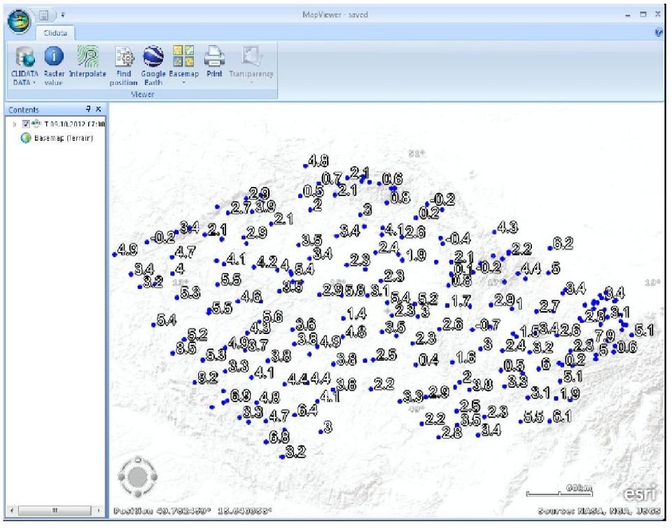
10 Map Viewer Is the tool user for simple mapping. Available features: Simple station Maps Display data stored in Clidata or in local text Files Make surface maps from station data Can use WMS Layers Can use static climatological maps Export data in KML format(google Earth) Using ArcGIS Explorer freeware from ESRI
 Using")
11


12 Clidata GIS and Spatial Analysis Is the Advanced Clidata mapping Tool. With This tool you can: Create any map using Clidata application Make surfaces from station Geography Work with any data in Clidata including Daily, Monthly, Extremes, Normals, etc... Includes interpolation methods: IDW, LLR, Clidata DEM, Clidata DEM R2 Smoothing surfaces Making isolines Calculate zone statistics Calculate rasters Simple user friendly export to many formats including PNG and PDF

13 Clidata Area Control Is the highest quality control level in Clidata. The values are crated as square fields meaning the interval of probability of exceeding. Quality control can be processed automatically or by human. Every station is compared with its surrounding stations. The value can be estimated by linear regression from its surrounding stations.

14 Station Geography The information on station geography is available be means of well-arranged forms. The main features of this form have been adopted from the old Clicom system. The basic information has been extended and currently the users can maintain all the station documentation in one place. This definition of the station is the basis for data input checking. It is not possible to store the data for an undefined station. The following additional information can be managed for station: Basic station geography Station ID Name Period of measurement Longitude Latitude Elevation Country Region District Other station Ids Elevation Address Etc. Station Observation Elements Period of measurements Time Scheme Instrument Calculations Interpolation Maps the map pictures. Additional information can be added to the map. Photos complete digital photo documentation for each of the stations. Heliographic horizon the horizontal shape of the surrounding landscape, natural and artificial obstacles are recorded in this part of the station geography. Extended station information the additional information about pedology, anthropogenic influence, vegetation cover and relief. Hydrological information additional information related to hydrology Observers the list of current and ex-observers. Station documentation the various types of documentation, e.g. MS Word or Excel files. Instruments the list of all station instruments Measurement profile curves relation between water flow and water height Polygon information for station representing the polygon this part stores another information of polygon area data Reference stations different reference stations related to this station Obstacles the influence of surrounding especially used for the influence of the wind measurement Station groups station can become member of some group. Many products can be run for the group of stations instead for one particular station.


15 Additional station information Google Maps Heliographic horizon Station instruments Maps Photos Station Files Measurement Profile Curves


16 Key Entry Forms In the Clidata system data can also be entered manually by transcribing data from paper forms filled by observers. The user can design his/her own key entry forms according to his/her needs and to precisely correspond to the original paper forms. The data are keyed in well-arranged forms designed for user comfort. The keying system is based on the mature entry forms used in the Clicom system hence, users adapted to the new system easily. In the key entry forms the users can take advantage of the Quality Control checksums in rows or in the columns. Daily data layout: Day X Element+Time Daily data layout: Day X Station +Element The arrangement of key entry form is up to user. Any layout of Station, Element, Year, Month, Day and time filed is possible. Moreover specialized key entry forms for Rainfall Intensity, Meteorological Phenomena, Upper Air data is available. Meteorological phenomena Upper Air Data Intensity Rainfall

17 Automatic Derivative Calculation The Clidata system introduces user-defined automatic calculation of many derived elements from daily measured values. The derivatives system adopts a simple, user-friendly approach, such that the user defines only what he/she wants to calculate and the Clidata system carries out the calculations automatically without interaction. The definition of the formulas used for the calculation is very flexible, and the user is able to define very complex calculations. The system is able to calculate: Hourly values the definition of the general formula related to a time during a day. For example, the calculation of relative humidity from the temperature, wet bulb temperature, pressure and wind speed, or the calculation of the absolute difference between two consecutive observation of the same element. Temp Wet Daily aggregated values the definition of the general formula for daily maximum, minimum, sum or average. Temp 14:00 Monthly/Yearly values definition of the calculation, not only for the month and year, but also for the 13 decade or 1-6 pentade of the month. You can calculate the maximum, minimum, sum or average for these time periods. Alternatively, you can calculate the number of days which satisfy certain conditions over a period (e.g. the number of "summer days", where temperature for a "summer day" is above 25 C). Temp Day 02 Normals definition of the long term calculation of the normal values; calculated for each month and for the year.

18 Extreme values user-defined calculation of the long term minima, maxima and averages. Value interpolation for the data measured regularly during a day the system can automatically infill missed values from those neighbouring by the interpolation process. Other automatic calculations Days with phenomenon the system automatically calculates the number of days in month and year in which the specific phenomenon has been observed. From this, the system also calculates (for long term period) the normal number of days for each of the months and for the year. Normal number of phenomena from monthly phenomena count the normal number is calculated Standard isobaric levels for Upper Air Data from raw data standard levels are calculated Interpolated values for Upper Air Data missing values are interpolated for all available pressure levels
 the normal number of days for each of the months and for the year.")
19 Automatic Imports The import of formatted text files is built into Clidata. The user defines their own method for each of the import text file types. The definition of the import method is very flexible and allows a wide range text file formats. After the creation of the import method the user sets up import job to carry out loading at regular intervals. For standard WMO messages and not well formatted files the decode method is implemented in Clidata system. We can decode the following WMO messages: SYNOP CLIMAT CLIAMT TEMP BUFR Various Upper Air data formats (AED, Vaisala text files, ) Decode method transfers the file into well formatted file suitable for Clidata import system. All structured files can be imported into Clidata. When reqired new decode methods can be implemented. The import system is so flexible that all data in Czech Republic are imported by means of this system. Different kinds of the data are imported: daily data observed by observers and measured by automatic stations or data from the international exchange (the SYNOP messages), meteorological phenomena, one minute precipitation data etc.


20 Data Quality Control The data in Clidata are checked in the following levels. Basic levels are processed during key entry or during import of the data to the system. Advanced check are processed after the data are input into the system. Special application for Area control is the implemented as standalone module for data checking and is described in other part of this document. Basic Checks during key entry or Automatic import Integrity within the system Station, element and observation definition must exists Error Limits data outside this limits are not stored Warning Limits data are stored, but are highlighted as suspicious Rounding and scale Advanced Checks Data are checked by Quality Control Formula. User can define general formula with the specification of the relation between elements. The General formula can be very complex including any comparison and logical operators. The suspicious values are highlighted with different colours and errors or warnings are indicated. This kind of control is utilized after manual Key entry. For many stations and long periods the Clidata system uses Batch Quality Control. This check are done by the same quality control formula. This utility is useful for checking historical and imported data. General quality control formula are not very effective for regular data (Data from Automatic weather stations).


21 Therefore Clidata introduces Automatic checks by simple formulas of actual regular data. Simple formulas are useful to find exceptional values above some predefined limits, peaks and unusual repeated values.

22 Wind Roses One of the often used product is wind rose creation. Clidata can create 8,12,16,18 and 36 direction wind rose. Wind rose is calculated for relative or absolute count of occurrences or for average wind speed.
23 Data protection Data in Clidata are protected by several tools: Oracle protection - data are stored in database therefore all oracle data security is available Data are protected by Oracle against corruption Automatic Backup and Export enhance the data protection Definition of User each person interacting with the system connect be it own user Database Rights user is assigned by rights to tables or views. Without the right the user is not able to work with particular table or view Restrictions allows to limit user only on the part of the data (Restricted in space and time) READ user is able to read only part of the data WRITE/MODIFY user is able to modify only part of the data Restriction can be for example as follows: Restrict user only to READ years 1990 till 2000 (see all data modify years ) Restrict user only to READ/WRITE station O1PORU01 (user does not see and modify other data than data belonging to station O1PORU01) Application protection definition of the acces to only parts of the Clidata application. Application protection can be for example as follows: User can do Key Entry but is not able to do Quality Control. User can read Station Geography and view products but is not able to do Key entry User can only view products Roles Each Application and Oracle protection can be grouped into more complex ROLES. Typical roles identified in the system are: Key Entry Person Quality Control Person Person Responsible for Products Administrator Roles can be more or less specific depending on requirements.

24 Standard DATA Exchange Exports Clidata is able to create standard WMO Messages of the following Formats as the standard products: CLIMAT CLIMAT TEMP BUFR SYNOP BUFR TEMP WORLD WEATHER RECORDS The creation can be manual or automatic.
Final Report - HydrometDB Belize s Climatic Database Management System. Executive Summary
 Executive Summary Belize s HydrometDB is a Climatic Database Management System (CDMS) that allows easy integration of multiple sources of automatic and manual stations, data quality control procedures,
WMO Climate Database Management System Evaluation Criteria
 ANNEX 8 WMO Climate Database Management System Evaluation Criteria System Name: Version: Contributing Country: Contact Information Contact Person: Telephone: FAX: Email address: Postal address: Date: General
Quality Assurance for Hydrometric Network Data as a Basis for Integrated River Basin Management
 Quality Assurance for Hydrometric Network Data as a Basis for Integrated River Basin Management FRANK SCHLAEGER 1, MICHAEL NATSCHKE 1 & DANIEL WITHAM 2 1 Kisters AG, Charlottenburger Allee 5, 52068 Aachen,
LabStats 5 System Requirements
 LabStats Tel: 877-299-6241 255 B St, Suite 201 Fax: 208-473-2989 Idaho Falls, ID 83402 LabStats 5 System Requirements Server Component Virtual Servers: There is a limit to the resources available to virtual
Basic Climatological Station Metadata Current status. Metadata compiled: 30 JAN 2008. Synoptic Network, Reference Climate Stations
 Station: CAPE OTWAY LIGHTHOUSE Bureau of Meteorology station number: Bureau of Meteorology district name: West Coast State: VIC World Meteorological Organization number: Identification: YCTY Basic Climatological
Cookbook 23 September 2013 GIS Analysis Part 1 - A GIS is NOT a Map!
 Cookbook 23 September 2013 GIS Analysis Part 1 - A GIS is NOT a Map! Overview 1. A GIS is NOT a Map! 2. How does a GIS handle its data? Data Formats! GARP 0344 (Fall 2013) Page 1 Dr. Carsten Braun 1) A
MCH Meteorology, Climatology and Hydrology Data base Management System
 WMO World Meteorological Organization Working together in weather, climate and water MCH Meteorology, Climatology and Hydrology Data base Management System WMO, Climate and Water department: Nirina Ravalitera
Studying Topography, Orographic Rainfall, and Ecosystems (STORE)
") Studying Topography, Orographic Rainfall, and Ecosystems (STORE) Basic Lesson 3: Using Microsoft Excel to Analyze Weather Data: Topography and Temperature Introduction This lesson uses NCDC data to compare
Studying Topography, Orographic Rainfall, and Ecosystems (STORE) Basic Lesson 3: Using Microsoft Excel to Analyze Weather Data: Topography and Temperature Introduction This lesson uses NCDC data to compare
Datzilla. Error Reporting and Tracking for NOAA Data
 Datzilla Error Reporting and Tracking for NOAA Data Overview Datzilla is a web based system used to report and track errors in NOAA datasets and Data Products. It is an adaptation of the software bug tracking
multimodality image processing workstation Visualizing your SPECT-CT-PET-MRI images
 multimodality image processing workstation Visualizing your SPECT-CT-PET-MRI images InterView FUSION InterView FUSION is a new visualization and evaluation software developed by Mediso built on state of
McKesson Radiology 12.0 Technical Requirements
 McKesson Radiology 12.0 Technical Requirements McKesson Radiology Version 12.0 is designed to not require workstation replacement, assuming the legacy McKesson PACS hardware meets the specifications listed
Backup and Recovery. Introduction. Benefits. Best-in-class offering. Easy-to-use Backup and Recovery solution.
 DeltaV Distributed Control System Product Data Sheet Backup and Recovery Best-in-class offering. Easy-to-use Backup and Recovery solution. Data protection and disaster recovery in a single solution. Scalable
Oracle Primavera P6 Enterprise Project Portfolio Management Performance and Sizing Guide. An Oracle White Paper October 2010
 Oracle Primavera P6 Enterprise Project Portfolio Management Performance and Sizing Guide An Oracle White Paper October 2010 Disclaimer The following is intended to outline our general product direction.
GeoMedia Smart Client
 GEOSPATIAL GeoMedia Smart Client Dynamically Jumpstart Your GIS GeoMedia Smart Client Is your geographic information system (GIS) at a gridlock, stuck in a department, limited to a few, contained and
Introduction to GIS (Basics, Data, Analysis) & Case Studies. 13 th May 2004. Content. What is GIS?
 & Case Studies. 13 th May 2004. Content. What is GIS?") Introduction to GIS (Basics, Data, Analysis) & Case Studies 13 th May 2004 Content Introduction to GIS Data concepts Data input Analysis Applications selected examples What is GIS? Geographic Information
Introduction to GIS (Basics, Data, Analysis) & Case Studies 13 th May 2004 Content Introduction to GIS Data concepts Data input Analysis Applications selected examples What is GIS? Geographic Information
Hardware, Software and Training Requirements for DMFAS 6
 Hardware, Software and Training Requirements for DMFAS 6 DMFAS6/HardwareSoftware/V5 May 2015 2 Hardware, Software and Training Requirements for DMFAS 6 Contents ABOUT THIS DOCUMENT... 4 HARDWARE REQUIREMENTS...
Software. PowerExplorer. Information Management and Platform DATA SHEET
 DATA SHEET PowerExplorer Software Information Management and Platform KEY FEATURES Web-enabled Advanced, ad-hoc query capabilities Spatial E&P data presentation ZGF file import/export Spatializer Tabular
Guidelines on Quality Control Procedures for Data from Automatic Weather Stations
 WORLD METEOROLOGICAL ORGANIZATION COMMISSION FOR BASIC SYSTEMS OPEN PROGRAMME AREA GROUP ON INTEGRATED OBSERVING SYSTEMS EXPERT TEAM ON REQUIREMENTS FOR DATA FROM AUTOMATIC WEATHER STATIONS Third Session
Centralized Orchestration and Performance Monitoring
 DATASHEET NetScaler Command Center Centralized Orchestration and Performance Monitoring Key Benefits Performance Management High Availability (HA) Support Seamless VPX management Enables Extensible architecture
64 Bits of MapInfo Pro!!! and the next BIG thing. March 2015
 64 Bits of MapInfo Pro!!! and the next BIG thing March 2015 MapInfo Professional v12.5 Themes Cartographic output Performance improvements Ability to work directly with a map in a layout. An all new Layout
Backup and Recovery. Backup and Recovery. Introduction. DeltaV Product Data Sheet. Best-in-class offering. Easy-to-use Backup and Recovery solution
 April 2013 Page 1 Protect your plant data with the solution. Best-in-class offering Easy-to-use solution Data protection and disaster recovery in a single solution Scalable architecture and functionality
1.0 Hardware Requirements:
 01 - ServiceDesk Plus - Best Practices We appreciate you choosing ServiceDesk Plus for your organization to deliver world-class IT services. Before installing the product, take a few minutes to go through
Samsung device management solutions Manage, monitor and diagnose multiple print devices easily and cost effectively
 Samsung device management solutions Manage, monitor and diagnose multiple print devices easily and cost effectively Proactively identify equipment issues before they become problems. Economically manage,
McKesson Radiology 12.1.1 Technical Requirements
 McKesson Radiology 12.1.1 Technical Requirements McKesson Radiology Version 12.1.1 is designed to not require workstation replacement, assuming the legacy McKesson PACS hardware meets the specifications
HALOGEN. Technical Design Specification. Version 2.0
 HALOGEN Technical Design Specification Version 2.0 10th August 2010 1 Document Revision History Date Author Revision Description 27/7/09 D Carter, Mark Widdowson, Stuart Poulton, Lex Comber 1.1 First draft
E-Notebook 2014 Release 5. Hardware and Software Guide
 E-Notebook 2014 Release 5 Hardware and Software Guide Last Updated: June 5, 2015 Table of Contents 1 Introduction... 3 2 Hardware Requirements... 3 2.1 Database Server Hardware Requirements... 3 2.2 Web
Application of Google Earth for flood disaster monitoring in 3D-GIS
 Disaster Management and Human Health Risk II 271 Application of Google Earth for flood disaster monitoring in 3D-GIS M. Mori & Y. L. Chan Department of Information and Computer Science, Kinki University,
Implementation of a Web Portal for Managing and Sharing Environmental Data
 Implementation of a Web Portal for Managing and Sharing Environmental Data Prepared for: 2011 DoD Environmental Monitoring & Data Quality Workshop Presented by: Jason Samus EA Engineering, Science and
Enterprise Architectures for Large Tiled Basemap Projects. Tommy Fauvell
 Enterprise Architectures for Large Tiled Basemap Projects Tommy Fauvell Tommy Fauvell Senior Technical Analyst Esri Professional Services Washington D.C Regional Office Project Technical Lead: - Responsible
4Improving Monitoring
 4Improving Monitoring Powerful, flexible, open, scalable and adaptable to your needs A new way to monitoring and analyze the performance of you investment Full control when you need it! 4Improving SOLAR
Datacenter Infrastructure Management (DCIM) Solution
 Solution") Datacenter Infrastructure Management (DCIM) Solution Figure 1. Asset Management in 3D, Real-Time Reporting, CFD Modeling & Analysis Description Datacenter Clarity provides the tools to accurately and efficiently
Datacenter Infrastructure Management (DCIM) Solution Figure 1. Asset Management in 3D, Real-Time Reporting, CFD Modeling & Analysis Description Datacenter Clarity provides the tools to accurately and efficiently
CLOUD BASED N-DIMENSIONAL WEATHER FORECAST VISUALIZATION TOOL WITH IMAGE ANALYSIS CAPABILITIES
 CLOUD BASED N-DIMENSIONAL WEATHER FORECAST VISUALIZATION TOOL WITH IMAGE ANALYSIS CAPABILITIES M. Laka-Iñurrategi a, I. Alberdi a, K. Alonso b, M. Quartulli a a Vicomteh-IK4, Mikeletegi pasealekua 57,
GeoCloud Project Report USGS/EROS Spatial Data Warehouse Project
 GeoCloud Project Report USGS/EROS Spatial Data Warehouse Project Description of Application The Spatial Data Warehouse project at the USGS/EROS distributes services and data in support of The National
This guide specifies the required and supported system elements for the application.
 System Requirements Contents System Requirements... 2 Supported Operating Systems and Databases...2 Features with Additional Software Requirements... 2 Hardware Requirements... 4 Database Prerequisites...
PROJECT: ArcGIS Server Hosting
 QUOTE TO: Bridget Simpson Ohio EPA P 614.644.0043 E [email protected] [email protected] QUOTE DATE: June 11, 2010 QUOTE PRICE EXPIRES: 90 days from Quote Date Based on your request, Swova has
Cisco is a registered trademark or trademark of Cisco Systems, Inc. and/or its affiliates in the United States and certain other countries.
 Legal Notices Copyright 1999, 2009 BMC Software, Inc. Copyright 1996-2014 Numara Software, Inc. BMC, BMC Software, and the BMC Software logo are the exclusive properties of BMC Software, Inc., are registered
System Requirements Table of contents
 Table of contents 1 Introduction... 2 2 Knoa Agent... 2 2.1 System Requirements...2 2.2 Environment Requirements...4 3 Knoa Server Architecture...4 3.1 Knoa Server Components... 4 3.2 Server Hardware Setup...5
ManageEngine EventLog Analyzer. Best Practices Document
 ManageEngine EventLog Analyzer Best Practices Document Table of Contents System Requirements... 3 Up to 50 hosts... 3 Up to 100 hosts... 3 Up to 200 hosts... 3 Up to 500 hosts... 3 Above 500 hosts... 4
DATABASE ANALYST I DATABASE ANALYST II
 CITY OF ROSEVILLE DATABASE ANALYST I DATABASE ANALYST II DEFINITION To perform professional level work in designing, installing, managing, updating, and securing a variety of database systems, including
What is GIS? Geographic Information Systems. Introduction to ArcGIS. GIS Maps Contain Layers. What Can You Do With GIS? Layers Can Contain Features
 What is GIS? Geographic Information Systems Introduction to ArcGIS A database system in which the organizing principle is explicitly SPATIAL For CPSC 178 Visualization: Data, Pixels, and Ideas. What Can
MrSID Plug-in for 3D Analyst
 LizardTech MrSID Plug-in for 3D Analyst User Manual Copyrights Copyright 2009 2010 LizardTech. All rights reserved. Information in this document is subject to change without notice. The software described
NETWRIX IDENTITY MANAGEMENT SUITE
 NETWRIX IDENTITY MANAGEMENT SUITE FEATURES AND REQUIREMENTS Product Version: 3.3 February 2013. Legal Notice The information in this publication is furnished for information use only, and does not constitute
Eastern Caribbean Open-Source Geospatial Data Sharing and Management Workshop
 Eastern Caribbean Open-Source Geospatial Data Sharing and Management Workshop Data Collection and Management in the Caribbean Spice Island Resort, St. George s, Grenada October 6 7, 2011 Presented by:
Introduction to GIS. http://libguides.mit.edu/gis
 Introduction to GIS http://libguides.mit.edu/gis 1 Overview What is GIS? Types of Data and Projections What can I do with GIS? Data Sources and Formats Software Data Management Tips 2 What is GIS? 3 Characteristics
Backup and Recovery. Backup and Recovery. Introduction. DeltaV Product Data Sheet. Best-in-class offering. Easy-to-use Backup and Recovery solution
 September 2013 Page 1 Protect your plant data with the solution. Best-in-class offering Easy-to-use solution Data protection and disaster recovery in a single solution Scalable architecture and functionality
CURRENT STATUS OF HYDROLOGICAL DATA MANAGEMENT SYSTEM IN SLOVENIA. Country report. Dr. Mira Kobold
 CURRENT STATUS OF HYDROLOGICAL DATA MANAGEMENT SYSTEM IN SLOVENIA Country report Dr. Mira Kobold Slovenian Environment Agency REPUBLIC OF SLOVENIA SURFACE WATERS NETWORK 186 operating measuring stations
AGRICULTURAL METEOROLOGICAL DATA, THEIR PRESENTATION AND STATISTICAL ANALYSIS
 CHAPTER 3 AGRICULTURAL METEOROLOGICAL DATA, THEIR PRESENTATION AND STATISTICAL ANALYSIS 3.1 INTRODUCTION Agricultural meteorology is the science that applies knowledge in weather and climate to qualitative
About As. In a team with the best. ESRI Bulgaria is the exclusive distributor of Esri Inc. for Bulgaria. Esri Inc.
 About As ESRI Bulgaria is an IT company, leader in the field of Geographic Information Systems (GIS) on the Bulgarian market. Offering the most advanced high-tech products, solutions and services, ESRI
GIS Databases With focused on ArcSDE
 Linköpings universitet / IDA / Div. for human-centered systems GIS Databases With focused on ArcSDE Imad Abugessaisa [email protected] 20071004 1 GIS and SDBMS Geographical data is spatial data whose
Red Hat Network Satellite Management and automation of your Red Hat Enterprise Linux environment
 Red Hat Network Satellite Management and automation of your Red Hat Enterprise Linux environment WHAT IS IT? Red Hat Network (RHN) Satellite server is an easy-to-use, advanced systems management platform
A GIS helps you answer questions and solve problems by looking at your data in a way that is quickly understood and easily shared.
 A Geographic Information System (GIS) integrates hardware, software, and data for capturing, managing, analyzing, and displaying all forms of geographically referenced information. GIS allows us to view,
Red Hat Satellite Management and automation of your Red Hat Enterprise Linux environment
 Red Hat Satellite Management and automation of your Red Hat Enterprise Linux environment WHAT IS IT? Red Hat Satellite server is an easy-to-use, advanced systems management platform for your Linux infrastructure.
IT Infrastructure Management
 IT Infrastructure Management Server-Database Monitoring An Overview XIPHOS TECHNOLOGY SOLUTIONS PVT LIMITED 32/3L, GARIAHAT ROAD (SOUTH) KOLKATA 700 078, WEST BENGAL, INDIA WWW.XIPHOSTEC.COM Xiphos Technology
DATA MANAGEMENT (DM) - (e.g. codes, monitoring) software offered to WMO Members for exchange
 - (e.g. codes, monitoring) software offered to WMO Members for exchange") DATA MANAGEMENT (DM) - (e.g. codes, monitoring) software offered to s for exchange Notified to WMO 10/11/2009 United States A library of functions and subroutines which can be used to encode and decode
DATA MANAGEMENT (DM) - (e.g. codes, monitoring) software offered to s for exchange Notified to WMO 10/11/2009 United States A library of functions and subroutines which can be used to encode and decode
Digital Workflow Collection Xerox FreeFlow Core. Brochure. Xerox FreeFlow Core and. Xerox FreeFlow Core Cloud. Streamlined. Seamless. Simple.
 Xerox FreeFlow Digital Workflow Collection Xerox FreeFlow Core Xerox FreeFlow Core Cloud Brochure Xerox FreeFlow Core and Xerox FreeFlow Core Cloud Streamlined. Seamless. Simple. What if you could run
FUJIFILM Recording Media U.S.A., Inc. LTO Ultrium Technology
 FUJIFILM Recording Media U.S.A., Inc. LTO Ultrium Technology 1 What is LTO Ultrium Technology? LTO stands for Linear Tape Open, since it is linear data tape, and targeted to open systems environments in
Making an image using altitude as background image
 Try to re-do the previous exercise with different settings under Distance in Km between gridlines, Maximum interpolation radius (in Km), Minimum number of nearest stations and Maximum number of nearest
Google Earth Digitale Wege in eine bekannte Welt Sep. 2006
 Google Earth Digitale Wege in eine bekannte Welt Sep. 2006 Joachim Glaubrecht Google Enterprise [email protected] What is Google Enterprise? 2 1 Focus.de: "Der Papst-Besuch in Google Earth" 3 How to Geo
Heikki Turtiainen *, Pauli Nylander and Pekka Puura Vaisala Oyj, Helsinki, Finland. Risto Hölttä Vaisala Inc, Boulder, Colorado
 4.1 A NEW HIGH ACCURACY, LOW MAINTENANCE ALL WEATHER PRECIPITATION GAUGE FOR METEOROLOGICAL, HYDROLOGICAL AND CLIMATOLOGICAL APPLICATIONS Heikki Turtiainen *, Pauli Nylander and Pekka Puura Vaisala Oyj,
InstaFile. Complete Document management System
 InstaFile Complete Document management System Index : About InstaFile 1.1 What is InstaFile 1.2 How does it work 1.3 Where you can use InstaFile 1.4 Why only InstaFile InstaFile features and benefits Start
3D Model of the City Using LiDAR and Visualization of Flood in Three-Dimension
 3D Model of the City Using LiDAR and Visualization of Flood in Three-Dimension R.Queen Suraajini, Department of Civil Engineering, College of Engineering Guindy, Anna University, India, [email protected]
Annex 9 CLIMSOFT. Presented by. Albert Mhanda (Zimbabwe) CDMS Evaluation Workshop, WMO, Geneva, Switzerland (27 May 1 June 2002)
 CDMS Evaluation Workshop, WMO, Geneva, Switzerland (27 May 1 June 2002)") Annex 9 CLIMSOFT Presented by Albert Mhanda (Zimbabwe) CDMS Evaluation Workshop, WMO, Geneva, Switzerland (27 May 1 June 2002) Background CLIMSOFT acronym for CLIMatic SOFTware Team product CLICOM Workshop,
Annex 9 CLIMSOFT Presented by Albert Mhanda (Zimbabwe) CDMS Evaluation Workshop, WMO, Geneva, Switzerland (27 May 1 June 2002) Background CLIMSOFT acronym for CLIMatic SOFTware Team product CLICOM Workshop,
What is GIS. What is GIS? University of Tsukuba. What do you image of GIS? Copyright(C) ESRI Japan Corporation. All rights reserved.
 ESRI Japan Corporation. All rights reserved.") What is GIS University of Tsukuba Graduate School of Life and Environmental Science April 21 st, 2011 What is GIS? What do you image of GIS? Gas Insulated Switch Groupe Interventional Speciale Geographic
What is GIS University of Tsukuba Graduate School of Life and Environmental Science April 21 st, 2011 What is GIS? What do you image of GIS? Gas Insulated Switch Groupe Interventional Speciale Geographic
Brainlab Node TM Technical Specifications
 Brainlab Node TM Technical Specifications BRAINLAB NODE TM HP ProLiant DL360p Gen 8 CPU: Chipset: RAM: HDD: RAID: Graphics: LAN: HW Monitoring: Height: Width: Length: Weight: Operating System: 2x Intel
Virtualization of ArcGIS Pro. An Esri White Paper December 2015
 An Esri White Paper December 2015 Copyright 2015 Esri All rights reserved. Printed in the United States of America. The information contained in this document is the exclusive property of Esri. This work
OPTIMIZATION OF DATABASE STRUCTURE FOR HYDROMETEOROLOGICAL MONITORING SYSTEM
 OPTIMIZATION OF DATABASE STRUCTURE FOR HYDROMETEOROLOGICAL MONITORING SYSTEM Ph.D. Robert SZCZEPANEK Cracow University of Technology Institute of Water Engineering and Water Management ul.warszawska 24,
EnterpriseLink Benefits
 EnterpriseLink Benefits GGY AXIS 5001 Yonge Street Suite 1300 Toronto, ON M2N 6P6 Phone: 416-250-6777 Toll free: 1-877-GGY-AXIS Fax: 416-250-6776 Email: [email protected] Web: www.ggy.com Table of Contents
Operationalise Predictive Analytics
 Operationalise Predictive Analytics Publish SPSS, Excel and R reports online Predict online using SPSS and R models Access models and reports via Android app Organise people and content into projects Monitor
Publishing Hosted 3D Feature Layers. An Esri White Paper September 2015
 An Esri White Paper September 2015 Copyright 2015 Esri All rights reserved. Printed in the United States of America. The information contained in this document is the exclusive property of Esri. This work
GEOGRAPHIC INFORMATION SYSTEMS CERTIFICATION
 GEOGRAPHIC INFORMATION SYSTEMS CERTIFICATION GIS Syllabus - Version 1.2 January 2007 Copyright AICA-CEPIS 2009 1 Version 1 January 2007 GIS Certification Programme 1. Target The GIS certification is aimed
ORACLE DATABASE 10G ENTERPRISE EDITION
 ORACLE DATABASE 10G ENTERPRISE EDITION OVERVIEW Oracle Database 10g Enterprise Edition is ideal for enterprises that ENTERPRISE EDITION For enterprises of any size For databases up to 8 Exabytes in size.
TEMS PRODUCTS PART IMPROVE IN WHITE EFFICIENCY WITH THE WORLD S MOST VERSATILE DATA PROCESSING TOOL
 TEMS PRODUCTS TITLE TEMS BROCHURE DISCOVERY IN COLOR SECOND PART IMPROVE IN WHITE EFFICIENCY WITH THE WORLD S MOST VERSATILE DATA PROCESSING TOOL 2 TEMS DISCOVERY 3.0 USER-DEFINED POST-PROCESSING TEMS
Statistical Data Management. Description
 Statistical Data Management Description Contents 1. Goals and Tasks... 2 1.1 Overview... 2 1.2 Proposed architecture... 4 2. Functionality... 5 2.1 Statistical data collection... 5 2.2 Database design...
ManageEngine EventLog Analyzer. Best Practices Document
 ManageEngine EventLog Analyzer Best Practices Document Table of Contents System Requirements... 3 Up to 50 hosts... 3 Up to 100 hosts... 3 Up to 200 hosts... 3 Up to 500 hosts... 3 Above 500 hosts... 4
Quality assurance for hydrometric network data as a basis for integrated river basin management
 Water in Celtic Countries: Quantity, Quality and Climate Variability (Proceedings of the Fourth InterCeltic Colloquium on Hydrology and Management of Water Resources, Guimarães, Portugal, July 2005). IAHS
Priority Pro v17: Hardware and Supporting Systems
 Introduction Priority Pro v17: Hardware and Supporting Systems The following provides minimal system configuration requirements for Priority with respect to three types of installations: On-premise Priority
StruxureWare TM Center Expert. Data
 StruxureWare TM Center Expert Data End to end data center infrastructure management software for monitoring and control of power, cooling, security and energy usage from the building through IT systems
Sawmill Log Analyzer Best Practices!! Page 1 of 6. Sawmill Log Analyzer Best Practices
 Sawmill Log Analyzer Best Practices!! Page 1 of 6 Sawmill Log Analyzer Best Practices! Sawmill Log Analyzer Best Practices!! Page 2 of 6 This document describes best practices for the Sawmill universal
Synergis Software 18 South 5 TH Street, Suite 100 Quakertown, PA 18951 +1 215.302.3000, 800.836.5440 www.synergissoftware.com version 20150330
 Synergis Software 18 South 5 TH Street, Suite 100 Quakertown, PA 18951 +1 215.302.3000, 800.836.5440 www.synergissoftware.com version 20150330 CONTENTS Contents... 2 Overview... 2 Adept Server... 3 Adept
Oracle Warehouse Builder 10g
 Oracle Warehouse Builder 10g Architectural White paper February 2004 Table of contents INTRODUCTION... 3 OVERVIEW... 4 THE DESIGN COMPONENT... 4 THE RUNTIME COMPONENT... 5 THE DESIGN ARCHITECTURE... 6
Microsoft Exchange Solutions on VMware
 Design and Sizing Examples: Microsoft Exchange Solutions on VMware Page 1 of 19 Contents 1. Introduction... 3 1.1. Overview... 3 1.2. Benefits of Running Exchange Server 2007 on VMware Infrastructure 3...
#9011 GeoMedia WebMap Performance Analysis and Tuning (a quick guide to improving system performance)
") #9011 GeoMedia WebMap Performance Analysis and Tuning (a quick guide to improving system performance) Messina Thursday, 1:30 PM - 2:15 PM Paul F. Deaver, Sr. Consultant Security, Government & Infrastructure
#9011 GeoMedia WebMap Performance Analysis and Tuning (a quick guide to improving system performance) Messina Thursday, 1:30 PM - 2:15 PM Paul F. Deaver, Sr. Consultant Security, Government & Infrastructure
ASHRAE Climatic Data Activities. Dru Crawley Didier Thevenard
 ASHRAE Climatic Data Activities Dru Crawley Didier Thevenard ASHRAE American Society of Heating Refrigerating and Air- Conditioning Engineers >50,000 members Major products: Handbooks (Fundamentals, Systems
Informatica Data Director Performance
 Informatica Data Director Performance 2011 Informatica Abstract A variety of performance and stress tests are run on the Informatica Data Director to ensure performance and scalability for a wide variety
Chapter 1: Introduction to ArcGIS Server
 Chapter 1: Introduction to ArcGIS Server At a high level you can think of ArcGIS Server as software that helps you take your geographic information and make it available to others. This data can be distributed
FOTOSTATION. The best media file organizer. It s organized
 FotoStation 7.0 FOTOSTATION The best media file organizer Find, process and share your digital assets Search locally and centrally Automate your workflow with actions Available in 12 languages It s organized
White Paper. Freeance Mobile for Cityworks
 White Paper Freeance Mobile for Cityworks Version 1.1 May 2012 Freeance Mobile for Cityworks Freeance Mobile for Cityworks 2012.1 is a mobile application for the following smartphones and tablets: iphone
Release 8.2 Hardware and Software Requirements. PowerSchool Student Information System
 Release 8.2 Hardware and Software Requirements PowerSchool Student Information System Released January 2015 Document Owner: Documentation Services This edition applies to Release 8.2 of the PowerSchool
ArcGIS Server Implementation HIGHS and lows
 ArcGIS Server Implementation HIGHS and lows GIS-T March 2011 Eric Abrams Iowa DOT [email protected] Agenda The Problem Timeline Future Discussion/Questions The Problem - 2006 How does Iowa DOT integrate
Xirrus Management System
 DATASHEET Xirrus Management System The Xirrus Management System is a wireless network lifecycle management platform enabling network administrators to efficiently operate, configure and maintain Xirrus
Zorba Asset Tracking Solution
 Asset Tracking Solution State-of-the art fleet management and vehicle tracking solution to increase your productivity. Affordable installation and operating costs Easy to install and operate User friendly
Choosing the right GIS framework for an informed Enterprise Web GIS Solution
 13 ANNUAL INTERNATIONAL CONFERENCE AND EXHIBITION ON GEOSPATIAL INFORMATION TECHNOLOGY AND APPLICATIONS Epicentre; Gurgaon, India; 19-21 January, 2010 Choosing the right GIS framework for an informed Enterprise
Microsoft Dynamics NAV 2015 Hardware and Server Requirements. Microsoft Dynamics NAV Windows Client Requirements
 Microsoft Dynamics NAV 2015 Hardware and Server Requirements Microsoft Dynamics NAV Windows Client Requirements Windows client. operating systems Hardware resources Reports Windows 8.1 Professional or
Enterprise GIS Solutions to GIS Data Dissemination
 Enterprise GIS Solutions to GIS Data Dissemination ESRI International User Conference July 13 17, 2009 Wendy M. Turner Senior GIS Engineer & Program Manager Freedom Consulting Group, LLC Building the Enterprise