NCDC's Application of Climate Data to Tourism Business Decision-Making
|
|
|
- Noah Summers
- 8 years ago
- Views:
Transcription
1 NCDC's Application of Climate Data to Tourism Business Decision-Making Climate, Weather, and Tourism Workshop November 14-15, 2008 East Carolina University Greenville, NC Neal Lott NOAA s National Climatic Data Center NOAA s National Climatic Data Center 1

2 How are our data used?...a few examples. Engineering design: Ice loads for towers, cables, wires, etc Wind loads for buildings, etc Heating/cooling requirements Drainage/runoff extremes (pipes, culverts) Aircraft operations: Crosswinds (runway design), instrument landing systems, etc Space shuttle accident investigation: Nexrad data Ship routing and oil rig placement Global re-analyses for climate trends assessment, etc HAZMAT operations and studies: oil spills, toxic release, etc Weather risk management industry (now > $40 billion per year) Insurance investigations and verification Court cases and criminal investigations Aircraft accident investigations Wind energy studies: Wind farms, US and overseas Commercial innovation and design: Typical and extreme conditions for a new market Tourism support NOAA s National Climatic Data Center 2
 Insurance investigations and verification Court cases and criminal investigations")
3 Data Access at NOAA s National Climatic Data Center (User Categories) Earth (In-Situ) Platform Education 4% Government 6% Satellite Platform Commercial 90% Commercial 25% Government 70% Education 5% NOAA s National Climatic Data Center 3

4 NCDC Website NOAA s National Climatic Data Center 4

5 Search by. NOAA s National Climatic Data Center 5

6 Some of our Most Popular Services NOAA Virtual Data System (NVDS). Climate Data Online (CDO) Services, including. Quality Controlled Local Climatological Data, etc GIS Services Image and Publications System NEXRAD Radar Data Services NOAA s National Climatic Data Center 6

7 GIS-based Access to Data GIS Services GIS-based access and visualization of data Access to in-situ data, including NEXRAD Provides access to numerous datasets, products, and graphing OGC-compliant WMS, WFS Services implemented Access to Metadata Records in Geospatial One Stop and Global Change Master Directory NOAA Enterprise GIS Working Group (GEO-IDE) Google Earth compatibility Capability to overlay various GIS layers of interest to tourism NOAA s National Climatic Data Center
 Google Earth compatibility Capability")
8 Climate Data Online (CDO) Numerous datasets and products Data easily loaded into spreadsheets and other software For example compare business cash flow to weather data NOAA s National Climatic Data Center 8

9 Climate Data Online NOAA s National Climatic Data Center 9

10 Climate Data Online NOAA s National Climatic Data Center 1 0

11 Climate Data Online NOAA s National Climatic Data Center 1 1

12 Local Climatological Data NOAA s National Climatic Data Center 1 2

13 QCLCD Output Sample NOAA s National Climatic Data Center 1 3

14 Climatological Normals/Averages Long-term averages and summaries for over 7000 US locations E.g., assist in decision-making for new tourism-business locations NOAA s National Climatic Data Center 1 4

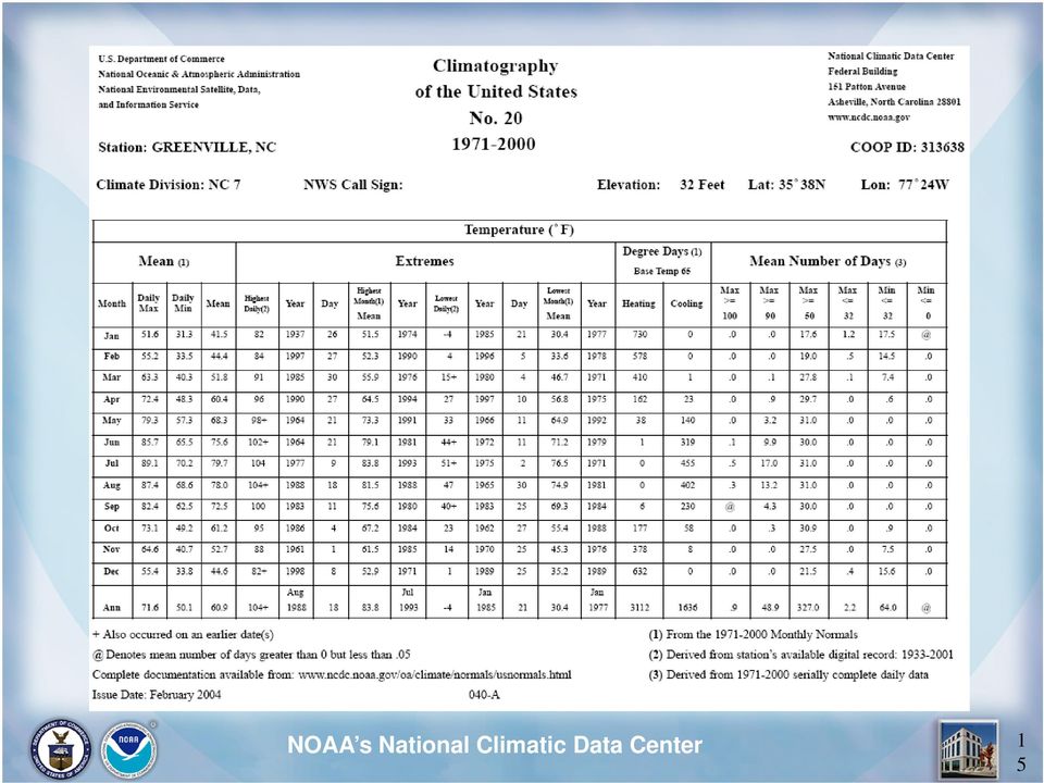
15 NOAA s National Climatic Data Center NOAA s National Climatic Data Center 1 5
16 Climatic Extremes Multiple parameters various extremes over long time periods E.g., determine typical extremes that may be expected in a city or county NOAA s National Climatic Data Center 1 6

17 Multivariate Summaries Multiple parameters various options and graphical displays E.g., determine frequencies of wind direction/speed for sporting events NOAA s National Climatic Data Center 1 7

18 NOAA s National Climatic Data Center NOAA s National Climatic Data Center 1 8

19 Serial Publications and Imaged Forms NCDC s five serial publications, issued monthly Cooperative station forms, as early as 1800 s to present E.g., highlight historical locations original reports from the observer NOAA s National Climatic Data Center 1 9

20 Search and download radar data Visualize data using custom NEXRAD Viewer National Radar Images available (1995-present) Storm Events database (1950- present) Radar Resources NOAA s National Climatic Data Center 2 0

21 Satellite Resources Historical Significant Events Imagery visualize Satellite data multiple products NOAA s National Climatic Data Center 2 1
22 And Now for Further Interaction, Questions, etc NOAA s National Climatic Data Center 2 2
Accessing Geographic Information Services and Visualization Products at NOAA s National Climatic Data Center
 Accessing Geographic Information Services and Visualization Products at NOAA s National Climatic Data Center Rich Baldwin *, Steve Ansari, and Neal Lott NOAA National Climatic Data Center, Asheville, North
NCDC Strategic Vision
 NOAA s National Climatic Data Center World s Largest Archive of Climate and Weather Data Presented to: Coastal Environmental Disasters Data Management Workshop September 16, 2014 Stephen Del Greco Deputy
GOSIC NEXRAD NIDIS NOMADS
 NOAA National Climatic Data Center GOSIC NEXRAD NIDIS NOMADS Christina Lief NOAA/NESDIS/NCDC GOSIC Program Manager NOAA/NESDIS/NCDC Asheville, NC 28801 GEOSS AIP Phase 2 Workshop September 25-26, 2008
André Karpištšenko, Co-Founder & Chief Scientist, Marinexplore Strata, 2014.02.11
 marineos André Karpištšenko, Co-Founder & Chief Scientist, Marinexplore Strata, 2014.02.11 The Ocean's Big Data Platform marineos: a platform for organizing, analyzing and distributing machine data marineos
The BASIS module in WindPRO is necessary for the use of any of the other calculation modules. It contains the four following elements:
 The BASIS module in WindPRO is necessary for the use of any of the other calculation modules. It contains the four following elements: 1. Project Management / Globe (Project Explorer) 2. WTG Catalogue
Using Big Data and GIS to Model Aviation Fuel Burn
 Using Big Data and GIS to Model Aviation Fuel Burn Gary M. Baker USDOT Volpe Center 2015 Transportation DataPalooza June 17, 2015 The National Transportation Systems Center Advancing transportation innovation
Unidata Policy Committee. Benjamin Watkins NOAA National Climatic Data Center
 Unidata Policy Committee Benjamin Watkins NOAA National Climatic Data Center National Climatic Data Center (NCDC) Asheville, North Carolina NCDC is the steward of the Nation s in-situ and satellite data
Final Report - HydrometDB Belize s Climatic Database Management System. Executive Summary
 Executive Summary Belize s HydrometDB is a Climatic Database Management System (CDMS) that allows easy integration of multiple sources of automatic and manual stations, data quality control procedures,
ART Vulnerability and Risk Assessment Report September 2012 Appendix C. ART GIS Exposure Analysis
 Adapting to Rising Tides GIS Exposure Analysis The aim of this appendix is to familiarize the reader with the data and methodology that was used to conduct an analysis of shoreline and community asset
COP Video & Data Integrations
 COP Video & Data Integrations COP: Common Operating Picture A Common Operating Picture (COP) is a computing platform based on Geographical Information System (GIS) technology that provides a single source
Communications Systems Used in the USA TARNS. Chris Hill, Meteorologist in Charge (ret) National Weather Service Seattle, Washington, USA
 National Weather Service Seattle, Washington, USA") Communications Systems Used in the USA TARNS Chris Hill, Meteorologist in Charge (ret) National Weather Service Seattle, Washington, USA Washington Faces Many Non-Weather Hazards Earthquakes Tsunamis Terrorism
Communications Systems Used in the USA TARNS Chris Hill, Meteorologist in Charge (ret) National Weather Service Seattle, Washington, USA Washington Faces Many Non-Weather Hazards Earthquakes Tsunamis Terrorism
Open Data and Big Data at NOAA
 Open and Big at NOAA Derek Hanson International Relations Specialist on behalf of Jeff de La Beaujardière, PhD NOAA Management Architect NOAA has "Big " 10 satellites 120+ weather radars 3 buoy networks
Baudouin Raoult, Iryna Rozum, Dick Dee
 ECMWF contribution to the EU funded CHARME Project: A Significant Event Viewer tool Matthew Manoussakis Baudouin Raoult, Iryna Rozum, Dick Dee 5th Workshop on the use of GIS/OGC standards in meteorology
Visualization and processing of weather radar data
 Visualization and processing of weather radar data 1 Learning Objectives The following are the learning objectives for this assignment: Learn how to request and retrieve NEXRAD data from the NCDC data
J9.6 GIS TOOLS FOR VISUALIZATION AND ANALYSIS OF NEXRAD RADAR (WSR-88D) ARCHIVED DATA AT THE NATIONAL CLIMATIC DATA CENTER
 ARCHIVED DATA AT THE NATIONAL CLIMATIC DATA CENTER") J9.6 GIS TOOLS FOR VISUALIZATION AND ANALYSIS OF RADAR (WSR-88D) ARCHIVED DATA AT THE NATIONAL CLIMATIC DATA CENTER Steve Ansari * STG Incorporated, Asheville, North Carolina Stephen Del Greco NOAA National
J9.6 GIS TOOLS FOR VISUALIZATION AND ANALYSIS OF RADAR (WSR-88D) ARCHIVED DATA AT THE NATIONAL CLIMATIC DATA CENTER Steve Ansari * STG Incorporated, Asheville, North Carolina Stephen Del Greco NOAA National
There are various ways to find data using the Hennepin County GIS Open Data site:
 Finding Data There are various ways to find data using the Hennepin County GIS Open Data site: Type in a subject or keyword in the search bar at the top of the page and press the Enter key or click the
The Arctic Observing Network and its Data Management Challenges Florence Fetterer (NSIDC/CIRES/CU), James A. Moore (NCAR/EOL), and the CADIS team
, James A. Moore (NCAR/EOL), and the CADIS team") The Arctic Observing Network and its Data Management Challenges Florence Fetterer (NSIDC/CIRES/CU), James A. Moore (NCAR/EOL), and the CADIS team Photo courtesy Andrew Mahoney NSF Vision What is AON? a
The Arctic Observing Network and its Data Management Challenges Florence Fetterer (NSIDC/CIRES/CU), James A. Moore (NCAR/EOL), and the CADIS team Photo courtesy Andrew Mahoney NSF Vision What is AON? a
The Use of Geographic Information Systems in Risk Assessment
 The Use of Geographic Information Systems in Risk Assessment With Specific Focus on the RiVAMP Methodology Presented by Nadine Brown August 27, 2012 Climate Studies Group Mona Climate Change Workshop Presentation
PART 1. Representations of atmospheric phenomena
 PART 1 Representations of atmospheric phenomena Atmospheric data meet all of the criteria for big data : they are large (high volume), generated or captured frequently (high velocity), and represent a
Texas Develops Online Geospatial Data Repository to Support Emergency Management
 Bing Maps for Enterprise Microsoft Customer Solution Case Study Texas Develops Online Geospatial Data Repository to Support Emergency Management Overview Country or Region: United States Industry: Government
Visualize your World. Democratization i of Geographic Data
 Visualize your World Democratization i of Geographic Data Session Agenda Google GEO Solutions - More than just a Map Enabling our Government Customers- Examples Summary & Invite to Learn More About Google
 Integrated Data Viewer (IDV) a visualization framework Yuan Ho Unidata Program Center Boulder, CO Presentation Outline Integrated Data Viewer (IDV) overview The IDV features IDV examples and customized
NOAA Environmental Data Management Update for Unidata SAC 2014-10-08
 NOAA Environmental Management Update for Unidata SAC 2014-10-08 Jeff de La Beaujardière, PhD NOAA Management Architect +1 301-713-7175 NOAA data are unique, valuable, and irreplaceable Many observing systems:
Figure 2: System Flow Diagram for Workflow Management
 5. WORKFLOW MANAGEMENT The developed system EASKB uses the open source content management system called Drupal ([2]). A Content Management System - CMS is a tool that enables many user friendly features
From Whitehall to orbit and back again: using space in government
 From Whitehall to orbit and back again: using space in government 18 th June 2014 Bristol 25 th June 2014 Liverpool 3 rd July 2014 -Newcastle Space for Smarter Government Programme (ssgp@sa.catapult.org.uk)
MD imap 2.0 THE NEXT GENERATION OF MARYLAND S ENTERPRISE GIS. Esri MUG Conference Baltimore, MD December 3, 2014 http://imap.maryland.
 THE NEXT GENERATION OF MARYLAND S ENTERPRISE GIS MD imap 2.0 Matt Sokol, GISP Senior GIS Analyst Maryland Department of Information Technology Geographic Information Office Julia Fischer, GISP Senior GIS
EXPLORING AND SHARING GEOSPATIAL INFORMATION THROUGH MYGDI EXPLORER
 EXPLORING AND SHARING GEOSPATIAL INFORMATION THROUGH MYGDI EXPLORER Subashini Panchanathan Malaysian Centre For Geospatial Data Infrastructure ( MaCGDI ) Ministry of National Resources and Environment
Oklahoma s Open Source Spatial Data Clearinghouse: OKMaps
 Oklahoma s Open Source Spatial Data Clearinghouse: OKMaps Presented by: Mike Sharp State Geographic Information Coordinator Oklahoma Office of Geographic Information MAGIC 2014 Symposium April 28-May1,
Sustainable Development for Smart Cities: A Geospatial Approach
 Middle East Geospatial Forum Dubai 16 th February 2015 Sustainable Development for Smart Cities: A Geospatial Approach Richard Budden Business Development Manager, Transportation and Infrastructure rbudden@esri.com,
Analysis of Climatic and Environmental Changes Using CLEARS Web-GIS Information-Computational System: Siberia Case Study
 Analysis of Climatic and Environmental Changes Using CLEARS Web-GIS Information-Computational System: Siberia Case Study A G Titov 1,2, E P Gordov 1,2, I G Okladnikov 1,2, T M Shulgina 1 1 Institute of
16 URBAN VISUALIZATION MODELLING
 16 URBAN VISUALIZATION MODELLING The Planning and Economic Development Committee recommends the adoption of the recommendation contained in the following report August 23, 2006, from the Commissioner of
Distributed Computing. Mark Govett Global Systems Division
 Distributed Computing Mark Govett Global Systems Division Modeling Activities Prediction & Research Weather forecasts, climate prediction, earth system science Observing Systems Denial experiments Observing
NOAA s National Climatic Data Center
 NOAA s National Climatic Data Center World s Largest Archive of Climate and Weather Data Presented to: Quarterly Meeting, Subcommittee of Hydrology, ACWI 23 October 2014 Dongsoo Kim, Ph.D. Project Scientist
GLOBAL CLIMATE MONITOR
 FP7 INCO- 2011 7 INCO- LAB project 294947 https://swanproject.arizona.edu/ GLOBAL CLIMATE MONITOR Natalia Limones (natalialr@us.es) José I. Alvarez (jose_afra@yahoo.es) Juan M. Camarillo (jmcamarillo@us.es)
2009 CAP Grant Kickoff USGS, Reston, VA May 21, 2009
 Leveraging GOS Map and Data Services for Search and Rescue Operations using NASA WorldWind Open Source 3D Visualization Platform Nadine Alameh, Ph.D. MobiLaps LLC 2009 CAP Grant Kickoff USGS, Reston, VA
Mapping Mashup/Data Integration Development Resources Teaching with Google Earth and Google Ocean Stone Lab August 13, 2010
 Mapping Mashup/Data Integration Development Resources Teaching with Google Earth and Google Ocean Stone Lab August 13, 2010 David Hart GIS Specialist University of Wisconsin Sea Grant Institute Virtual
Using Message Brokering and Data Mediation to use Distributed Data Networks of Earth Science Data to Enhance Global Maritime Situational Awareness.
 Using Message Brokering and Data Mediation to use Distributed Data Networks of Earth Science Data to Enhance Global Maritime Situational Awareness. Conor Delaney, Alfredo Alessandrini & Harm Greidanus
Fairfax County simplifies GIS search and opens more data to the public
 Fairfax County simplifies GIS search and opens more data to the public Fairfax County, Virginia has used MarkLogic to help simplify the process of searching data from dozens of geospatial information system
Pennsylvania Geospatial Data Sharing Standards (PGDSS) V 2.5
 V 2.5") Submitted to: Pennsylvania Geospatial Data Sharing Standards (PGDSS) V 2.5 Spatial Data Migration Tools Report May 2, 2007 Table of Contents 1.0 Document Purpose...B-1 2.0 Overview of Spatial Data Migration
Submitted to: Pennsylvania Geospatial Data Sharing Standards (PGDSS) V 2.5 Spatial Data Migration Tools Report May 2, 2007 Table of Contents 1.0 Document Purpose...B-1 2.0 Overview of Spatial Data Migration
Climate Data and Information: Issues and Uncertainty
 Climate Data and Information: Issues and Uncertainty David Easterling NOAA/NESDIS/National Climatic Data Center Asheville, North Carolina, U.S.A. 1 Discussion Topics Climate Data sets What do we have besides
Geospatial exploitation Products. GXP WebView. Powered by the GXP Platform
 Geospatial exploitation Products GXP WebView Powered by the GXP Platform Exploitation Capabilities GXP WebView Powered by the GXP Platform Detailed annotation (text, points, lines, and polygons) Distance,
DISMAR: Data Integration System for Marine Pollution and Water Quality
 DISMAR: Data Integration System for Marine Pollution and Water Quality T. Hamre a,, S. Sandven a, É. Ó Tuama b a Nansen Environmental and Remote Sensing Center, Thormøhlensgate 47, N-5006 Bergen, Norway
Environmental Data Services for Delaware:
 Environmental Data Services for Delaware: Serving Emergency Responders, Planners, and Researchers Network Delaware Day November 6, 2013 Overview Operational Data Services More than just research DEOS and
Norwegian Satellite Earth Observation Database for Marine and Polar Research http://normap.nersc.no USE CASES
 Norwegian Satellite Earth Observation Database for Marine and Polar Research http://normap.nersc.no USE CASES The NORMAP Project team has prepared this document to present functionality of the NORMAP portal.
Malcolm L. Spaulding Professor Emeritus, Ocean Engineering University of Rhode Island Narragansett, RI 02881
 Malcolm L. Spaulding Professor Emeritus, Ocean Engineering University of Rhode Island Narragansett, RI 02881 USACE Coastal and Hydraulics Laboratory(CHL) Data Infrastructure Workshop January 23, 2014 Overview
Geospatial Software Solutions for the Environment and Natural Resources
 Geospatial Software Solutions for the Environment and Natural Resources Manage and Preserve the Environment and its Natural Resources Our environment and the natural resources it provides play a growing
Designing the GIS/Website Interface Millennium Earth Project: A Visual Framework for Sustainable Development (Virtual Global Earth Project)
") Designing the GIS/Website Interface Millennium Earth Project: A Visual Framework for Sustainable Development (Virtual Global Earth Project) Table of Contents Summary of the project... 3 Major Tasks...
Designing the GIS/Website Interface Millennium Earth Project: A Visual Framework for Sustainable Development (Virtual Global Earth Project) Table of Contents Summary of the project... 3 Major Tasks...
The distribution of marine OpenData via distributed data networks and Web APIs. The example of ERDDAP, the message broker and data mediator from NOAA
 The distribution of marine OpenData via distributed data networks and Web APIs. The example of ERDDAP, the message broker and data mediator from NOAA Dr. Conor Delaney 9 April 2014 GeoMaritime, London
Open Source Visualisation with ADAGUC Web Map Services
 Open Source Visualisation with ADAGUC Web Map Services Maarten Plieger Ernst de Vreede John van de Vegte, Wim Som de Cerff, Raymond Sluiter, Ian van der Neut, Jan Willem Noteboom 1 ADAGUC project Cooperative
Tracking Track anything from relatively simplistic commercial GPS-enabled cell phones to complex military grade GPS signals.
 HazNet has been developed specifically to reduce the risk and attendant costs of moving and managing Hazardous Materials. The key to the efficiency of this system was the integration of IRRIS. IRRIS developed
Preliminary advances in Climate Risk Management in China Meteorological Administration
 Preliminary advances in Climate Risk Management in China Meteorological Administration Gao Ge Guayaquil,Ecuador, Oct.2011 Contents China Framework of Climate Service Experience in Climate/disaster risk
Flight information that keeps pilots a step ahead.
 Integrated Flight Information system Flight information that keeps pilots a step ahead. At Rockwell Collins, we re ushering in the era of the truly paperless flight deck while providing a higher level
Interoperable Solutions in Web-based Mapping
 ISPRS SIPT IGU UCI CIG ACSG Table of contents Table des matières Authors index Index des auteurs Search Recherches Exit Sortir Interoperable Solutions in Web-based Mapping Marta Wojnarowska and Bridget
GEOGRAPHIC INFORMATION SOLUTIONS LTD. GPS Data Management & GIS Course
 GEOGRAPHIC INFORMATION SOLUTIONS LTD GPS Data Management & GIS Course 4th Floor-Outbox, Soliz House, Plot 23, Lumumba Avenue, Nakasero, Kampala Uganda. Mobile: +256 778 082 563/+256 712 593 775 Email:
Jozef Matula. Visualisation Team Leader IBL Software Engineering. 13 th ECMWF MetOps Workshop, 31 th Oct - 4 th Nov 2011, Reading, United Kingdom
 Visual Weather web services Jozef Matula Visualisation Team Leader IBL Software Engineering Outline Visual Weather in a nutshell. Path from Visual Weather (as meteorological workstation) to Web Server
CLASS and Enterprise Solutions Rick Vizbulis. CLASS and Enterprise Solutions
 NOAA Science Advisory Board s December 7-8, 2006 CLASS and Enterprise Solutions CLASS and Enterprise Solutions Rick Vizbulis 1 Agenda! CLASS history! What is an archive?! Archive responsibilities! What
Commercial Internet Mapping Impacts on Government Investments in GIS. Wansoo Im, Ph.D. VERTICES, LLC New Brunswick, NJ
 Commercial Internet Mapping Impacts on Government Investments in GIS Wansoo Im, Ph.D. VERTICES, LLC New Brunswick, NJ Acknowledgements: Research funded by the Korean Land Spatialization Group Principal
Data access and management
 B Data access and management CONTENTS B.1 Introduction... B-1 B.2 Data requirements and availability... B-1 B.3 Data access... B-2 B.4 Overall procedures... B-2 B.5 Data tools and management... B-4 Appendix
Steve Ansari *, Stephen Del Greco, Brian Nelson, and Helen Frederick NOAA National Climatic Data Center, Asheville, North Carolina 2.
 11.4 THE SEVERE WEATHER DATA INVENTORY (SWDI): SPATIAL QUERY TOOLS, WEB SERVICES AND DATA PORTALS AT NOAA S NATIONAL CLIMATIC DATA CENTER (NCDC) Steve Ansari *, Stephen Del Greco, Brian Nelson, and Helen
The Role of Resource Assessment in Scaling Up Renewable Energy
 The Role of Resource Assessment in Scaling Up Renewable Energy Charging Ahead: Scaling Up Renewable Energy in the Developing World Nisha Thirumurthy October 27, 2015 NREL is a national laboratory of the
New challenges of water resources management: Title the future role of CHy
 New challenges of water resources management: Title the future role of CHy by Bruce Stewart* Karl Hofius in his article in this issue of the Bulletin entitled Evolving role of WMO in hydrology and water
Conservation Workshop ArcGIS Explorer
 Conservation Workshop ArcGIS Explorer Bern Szukalski bszukalski@esri.com Topics for this session Introduction Overview of features Using ArcGIS Explorer effectively New features & capabilities Customization
End to End Multi Hazard Early Warning Systems By Curt Barrett Hydrometeorological Consultant
 End to End Multi Hazard Early Warning Systems By Curt Barrett Hydrometeorological Consultant Disaster Risk Management- East Asia and Pacific Experts Roundtable on Urban Flood Risk Management March 17,
GEO 425, Spring 2012 LAB 3: Introduction to Web Map Services
 GEO 425, Spring 2012 LAB 3: Introduction to Web Map Services Objectives: If you have your own web server, it's great to be able to host your own geospatial data. That data can then be accessed through
INPE Spatial Data Infrastructure for Big Spatiotemporal Data Sets. Karine Reis Ferreira (INPE-Brazil)
") INPE Spatial Data Infrastructure for Big Spatiotemporal Data Sets Karine Reis Ferreira (INPE-Brazil) INPE (Brazil) and Big Data I work at INPE (Brazilian National Institute for Space Research). Main gate
INPE Spatial Data Infrastructure for Big Spatiotemporal Data Sets Karine Reis Ferreira (INPE-Brazil) INPE (Brazil) and Big Data I work at INPE (Brazilian National Institute for Space Research). Main gate
Building Caribbean GeoNode Platform in Support of Climate Risk Management Jacob Opadeyi, PhD
 Building Caribbean GeoNode Platform in Support of Climate Risk Management Jacob Opadeyi, PhD Our Highly Vulnerable Region Housing developments on drainage channels and steep slopes Unapproved development
ROOF-GUARD 101. Affordable Roof Protection For Asphalt Shingles. Manufactured By
 ROOF-GUARD 101 Affordable Roof Protection For Asphalt Shingles Manufactured By 1019 SE Holbrook Ct. Port St. Lucie, FL, 34952 Phone: 772-335-8225 sales@enviroseal.com Enviroseal has been instrumental in
Chapter 6: Data Acquisition Methods, Procedures, and Issues
 Chapter 6: Data Acquisition Methods, Procedures, and Issues In this Exercise: Data Acquisition Downloading Geographic Data Accessing Data Via Web Map Service Using Data from a Text File or Spreadsheet
Geospatially Enabling the World: The Convergence of Geospatial and Architectural and Engineering Design
 Geospatially Enabling the World: The Convergence of Geospatial and Architectural and Engineering Design Geoff Zeiss Director of Technology Autodesk Map Middle East Dubai 2007 1 Overview Geospatial inflection
TRMM and Other Global Precipitation Products and Data Services at NASA GES DISC. Zhong Liu George Mason University and NASA GES DISC
 TRMM and Other Global Precipitation Products and Data Services at NASA GES DISC Zhong Liu George Mason University and NASA GES DISC Outline Introduction of data and services at GES DISC TRMM and other
LEOworks - a freeware to teach Remote Sensing in Schools
 LEOworks - a freeware to teach Remote Sensing in Schools Wolfgang Sulzer Institute for Geography and Regional Science University of Graz Heinrichstrasse 36, A-8010 Graz/Austria wolfgang.sulzer@uni-graz.at
ArcGIS Framework Plug-In: Extending the ArcGIS Desktop for ANSI Standard Framework Data to Support Government Decision Making
 ArcGIS Framework Plug-In: Extending the ArcGIS Desktop for ANSI Standard Framework Data to Support Government Decision Making Final Project Report October 28, 2008 Agreement Number Organization Project
CURSO Inspire INSPIRE. SPEAKER: Pablo Echamendi Lorente. JEUDI 23/ THURSDAY 23 rd W S V : G E O S P A T I A L D A T A A C C E S S
 CURSO Inspire JEUDI 23/ THURSDAY 23 rd SPEAKER: Pablo Echamendi Lorente WS 5 SCHEDULE WMS OVERVIEW ACTIONS OGC SPECIFICATIONS OTHER SERVICES OVERVIEW proposal: Member States shall establish and operate
SCIENCE-BASED GIS SOLUTIONS. www.earthanalytic.com
 SCIENCE-BASED GIS SOLUTIONS www.earthanalytic.com Pipeline Routing, Site Selection, Cost Estimation and Risk Management Tools for Energy SmartFootprint is an extension to ArcGIS designed to assist planning,
MEMORANDUM. Background and Metadata. 9 February 2012
 MEMORANDUM From: Karin Gleason, Climate Monitoring Branch, CSMD, NCDC To: Thomas R. Karl, Director, NCDC Subject: SCEC Decision: New record 24 hour precipitation for New York 9 February 2012 On 1 February
A Project to Create Bias-Corrected Marine Climate Observations from ICOADS
 A Project to Create Bias-Corrected Marine Climate Observations from ICOADS Shawn R. Smith 1, Mark A. Bourassa 1, Scott Woodruff 2, Steve Worley 3, Elizabeth Kent 4, Simon Josey 4, Nick Rayner 5, and Richard
Primary author: Kaspar, Frank (DWD - Deutscher Wetterdienst), Frank.Kaspar@dwd.de
, Frank.Kaspar@dwd.de") Primary author: Kaspar, Frank (DWD - Deutscher Wetterdienst), Frank.Kaspar@dwd.de Co-authors: Johannes Behrendt (DWD - Deutscher Wetterdienst), Klaus-Jürgen Schreiber (DWD - Deutscher Wetterdienst) Abstract
Primary author: Kaspar, Frank (DWD - Deutscher Wetterdienst), Frank.Kaspar@dwd.de Co-authors: Johannes Behrendt (DWD - Deutscher Wetterdienst), Klaus-Jürgen Schreiber (DWD - Deutscher Wetterdienst) Abstract
CAPRA Software Gabriel Bernal ITEC SAS - ERN-AL Consortium
 CAPRA Software Gabriel Bernal ITEC SAS - ERN-AL Consortium ERN CAPRA software CAPRA platform Data management FileCAT Hazard module Exposure module Vulnerability module Risk module CRISIS 2007 ERN-NH rainfall
Finnish Meteorological Institute s Services for Insurance Sector
 Finnish Meteorological Institute s Services for Insurance Sector Regional training workshop Role of the NMHSs in support of DRR- related activities in the field of insurance Janne Miettinen, Account Manager,
A.1 Sensor Calibration Considerations
 Wind Speed and Direction Appendix A. Quality Assurance A major pre-requisite for establishing quality control standards for wind measurements is a strong quality assurance program. Remember the mantra
OBJECT BASED IMAGE CLASSIFICATION AND WEB-MAPPING TECHNIQUES FOR FLOOD DAMAGE ASSESSMENT
 OBJECT BASED IMAGE CLASSIFICATION AND WEB-MAPPING TECHNIQUES FOR FLOOD DAMAGE ASSESSMENT Ejaz Hussain, KyoHyouk Kim, Jie Shan {ehussain, kim458, jshan}@ecn.purdue.edu Geomatics Engineering, School of Civil
Very High Resolution Arctic System Reanalysis for 2000-2011
 Very High Resolution Arctic System Reanalysis for 2000-2011 David H. Bromwich, Lesheng Bai,, Keith Hines, and Sheng-Hung Wang Polar Meteorology Group, Byrd Polar Research Center The Ohio State University
Environment Canada Data Management Program. Paul Paciorek Corporate Services Branch May 7, 2014
 Environment Canada Data Management Program Paul Paciorek Corporate Services Branch May 7, 2014 EC Data Management Program (ECDMP) consists of 5 foundational, incremental projects which will implement
smespire - Exercises for the Hands-on Training on INSPIRE Network Services April 2014 Jacxsens Paul SADL KU Leuven
 smespire - Exercises for the Hands-on Training on INSPIRE Network Services April 2014 Jacxsens Paul SADL KU Leuven These exercises aim at people who already have some basic knowledge of INSPIRE Network
ArcGIS Data Models Practical Templates for Implementing GIS Projects
 ArcGIS Data Models Practical Templates for Implementing GIS Projects GIS Database Design According to C.J. Date (1995), database design deals with the logical representation of data in a database. The
Wildfire Prevention and Management in a 3D Virtual Environment
 Wildfire Prevention and Management in a 3D Virtual Environment M. Castrillón 1, P.A. Jorge 2, I.J. López 3, A. Macías 2, D. Martín 2, R.J. Nebot 3,I. Sabbagh 3, J. Sánchez 2, A.J. Sánchez 2, J.P. Suárez
Development of an Integrated Data Product for Hawaii Climate
 Development of an Integrated Data Product for Hawaii Climate Jan Hafner, Shang-Ping Xie (PI)(IPRC/SOEST U. of Hawaii) Yi-Leng Chen (Co-I) (Meteorology Dept. Univ. of Hawaii) contribution Georgette Holmes
How To Use The Alabama Data Portal
 113 The Alabama Metadata Portal: http://portal.gsa.state.al.us By Philip T. Patterson Geological Survey of Alabama 420 Hackberry Lane P.O. Box 869999 Tuscaloosa, AL 35468-6999 Telephone: (205) 247-3611
DIABLO VALLEY COLLEGE CATALOG 2015-2016
 GEOGRAPHY GEOG Tish Young, Dean Physical Sciences and Engineering Division Physical Sciences Building, Room 263 Possible career opportunities Geography is an interdisciplinary study focusing on the spatial
Requirements of Aircraft Observations data and Data Management Framework for Services and Other Data Users. (Submitted bymichael Berechree)
") WORLD METEOROLOGICAL ORGANIZATION WMO AMDAR PANEL WORKSHOP ON AIRCRAFT OBSERVING SYSTEM DATA MANAGEMENT Workshop on Aircraft Observing System Data Management/Doc.3.2 (31.V.2012) (GENEVA, SWITZERLAND, 5
WORLD METEOROLOGICAL ORGANIZATION WMO AMDAR PANEL WORKSHOP ON AIRCRAFT OBSERVING SYSTEM DATA MANAGEMENT Workshop on Aircraft Observing System Data Management/Doc.3.2 (31.V.2012) (GENEVA, SWITZERLAND, 5
The ORIENTGATE data platform
 Seminar on Proposed and Revised set of indicators June 4-5, 2014 - Belgrade (Serbia) The ORIENTGATE data platform WP2, Action 2.4 Alessandra Nuzzo, Sandro Fiore, Giovanni Aloisio Scientific Computing and
P2.7 Online Weather Studies in a 2-year program in Applied Meteorology at West Virginia State University
 P2.7 Online Weather Studies in a 2-year program in Applied Meteorology at West Virginia State University Tina J. Cartwright * and Steven Fleegel West Virginia State University 1. INTRODUCTION West Virginia
Implementation of information system to respond to a nuclear emergency affecting agriculture and food products - Case of Morocco
 Centre National de l énergie des sciences et techniques nucléaires (CNESTEN-Morocco) Implementation of information system to respond to a nuclear emergency affecting agriculture and food products - Case
Appendix J Online Questionnaire
 Appendix J Online Questionnaire In accordance with the Paperwork Reduction Act, this questionnaire was approved by the Office of Management and Budget (OMB). The OMB control number and expiration date
Working with Temporal Data
 Esri International User Conference San Diego, California Technical Workshops July 26 2012 Working with Temporal Data Aileen Buckley Mark Smithgall This technical workshop Visualizing temporal data recurring
SITE SPECIFIC WEATHER ANALYSIS REPORT
 SAMPLE FLOOD ANALYSIS REPORT SITE SPECIFIC WEATHER ANALYSIS REPORT PREPARED FOR: Law Offices of Oliver Wendell Douglas Oliver Wendell Douglas PREPARED BY: November 29, 2007 CASE REFERENCE: Arnold Ziffel
Intergraph Roadway Information Management Solution. Title Title. Title Title. A White Paper
 Intergraph Roadway Information Management Solution A White Paper Security, Government & Infrastructure, a division of Intergraph Title Title Title Title Table of Contents 1. Introduction... 1 2. Intergraph
Locus Technologies makes move to Asheville for data visualization
 Locus Technologies makes move to Asheville for data visualization Todd Pierce understands how easy it is to drown in the torrents of data washing over us in a digital age. Imagine a bookshelf running a
What s new in Carmenta Server 4.2
 What s new in Carmenta Server 4.2 A complete solution for cost-effective visualisation and distribution of GIS data through web services Carmenta Server provides cost-effective technology for building
Scientific Data Management and Dissemination
 Federal GIS Conference February 9 10, 2015 Washington, DC Scientific Data Management and Dissemination John Fry Solution Engineer, Esri jfry@esri.com Agenda Background of Scientific Data Management through