Steve Ansari *, Stephen Del Greco, Brian Nelson, and Helen Frederick NOAA National Climatic Data Center, Asheville, North Carolina 2.
|
|
|
- Louisa Morris
- 7 years ago
- Views:
Transcription
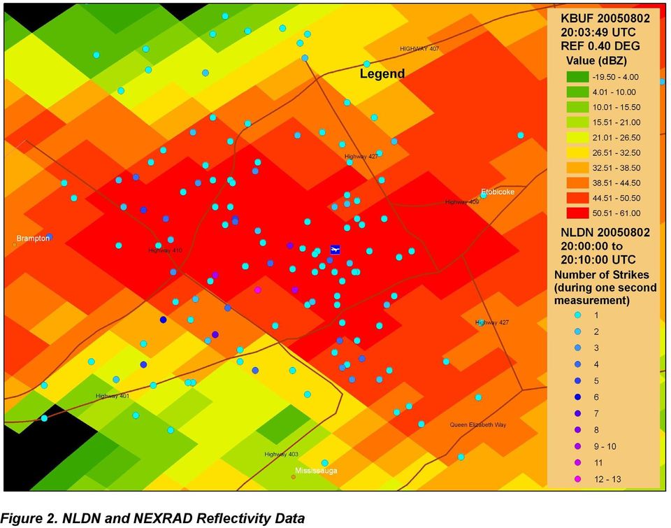
1 11.4 THE SEVERE WEATHER DATA INVENTORY (SWDI): SPATIAL QUERY TOOLS, WEB SERVICES AND DATA PORTALS AT NOAA S NATIONAL CLIMATIC DATA CENTER (NCDC) Steve Ansari *, Stephen Del Greco, Brian Nelson, and Helen Frederick NOAA National Climatic Data Center, Asheville, North Carolina ABSTRACT NOAA s National Climatic Data Center (NCDC) archives Weather Surveillance Radar, 1988 Doppler (WSR-88D) data from the national network of ~160 NWS, DOD and FAA sites. These are commonly referred to as Next-Generation Doppler Radars (NEXRAD). The NCDC NEXRAD Archive contains over 1000 terabytes of volume scan data, known as Level-II, and derived products, known as Level-III. Several of the products in the NEXRAD Level-III data stream are point features describing general storm structure, hail, mesocyclone and tornado signatures. The NCDC developed software package, Java NEXRAD Tools, is used to decode these features into an Oracle Spatial geo-spatial database [1; 6]. The Warning Decision Support System Integrated Information (WDSS-II) is used to generate storm cell, mesocyclone and tornado signatures from Level-II data using independent algorithms developed at the National Severe Storms Laboratory (NSSL) [3; 4]. The WDSS-II generated features are loaded into the geo-spatial database along with lightning data from the Vaisala s National Lightning Detection Network (NLDN) and observations from the NCDC Storm Events database [2; 8]. The Severe Weather Data Inventory (SWDI) provides user access to the geodatabase via the NCDC web page, Web Feature Services (WFS), SOAP or OPeNDAP [5; 7; 9]. The results of interactive web page queries may be saved in a variety of formats, including plain text, XML (GML), Well-Known Text, NetCDF and Shapefile [Appendix A]. 1. INTRODUCTION Severe weather impacts the lives of millions of people each year. The protection, planning, and response to these challenges are central to NOAA s mission. Part of this mission includes disaster planning, mitigation, and recovery which is often atop public perception and occupies many of NOAA s resources. Tools to aid in this mission are important for many reasons. Better preparedness and improved recovery can help save lives, reduce costs, and provide comfort. The development of NEXRAD Radar systems have dramatically improved severe weather detection and have saved countless lives. Algorithms developed at * Corresponding author address: Steve Ansari, NOAA National Climatic Data Center, 151 Patton Avenue, Asheville, NC 28801; Steve.Ansari@noaa.gov. the National Weather Service (NWS) and the National Severe Storms Laboratory (NSSL) use NEXRAD data to detect and track tornados, hail and mesocyclones in real-time. While these data are invaluable for real-time operations, historical analysis is also beneficial. Comparison with other independent data sources such as human observations and lightning sensors provides a long-term source of quality assurance. The observational data tends to show biased information because reports are often located in populated places or along major roads. The remotely sensed data allows for a more homogenously spaced distribution of weather information. 2. DATA The four initial data sources for the SWDI are the NEXRAD Level-III NWS-derived products, the NEXRAD WDSS-II severe weather output, the National Lightning Detection Network (NLDN) and the Storm Events database. The NEXRAD Level-III data are products generated with NWS algorithms from NEXRAD Level-II (base) volume scan data. Several of the Level-III products identify and describe severe weather. These products consist of mesocyclone, hail, tornado and storm structure point features which are decoded and geo-located using the Java NEXRAD Tools software package [1] (Figure 1). The counterpart of the Level-III data is the output from the NSSL s Warning Decision Support System Integrated Information (WDSS-II) software package [3; 4]. The WDSS-II runs independent algorithms from the NSSL on the NEXRAD Level-II data to derive mesocyclone, hail, tornado and storm structure features. The temporal resolution of both NEXRAD derived datasets is dependant on the scan mode of the Radar site and varies between 4 and 10 minutes. The entire NCDC archive of NEXRAD data will eventually be reprocessed to populate the SWDI. This includes general coverage of the continental United States since 1995 with the earliest data from The NLDN (NOAAPORT stream) data are generated from Vaisala s national network of lightning sensors. The sensors use time-of-arrival and magnetic direction finding to identify and geo-locate each lightning event [2] (Figure 2). The temporal resolution of NLDN data is one second. The Storm Events database consists of qualitative observations of events such as hail, tornados, lightning, flooding, high wind and more. The data either have a geographic coordinate specified or are organized by county or city. The Storm Events data are event

2 summaries and contain data from 1950 to the present [8] (Figure 3). 3. GEO-SPATIAL DATABASE An Oracle relational database with the Oracle Spatial extension is used to store the severe weather features. The database spatially links the diverse datasets together in a way that is not possible using conventional databases or data storage methods [6]. Having the severe weather data in a central geo-spatial database links the data to other NCDC datasets that are spatially registered in the database. The severe weather data can then be spatially joined to other datasets and vice versa. For example, the county, climate division, closest in situ sites, cities, schools and roads can easily be calculated for any spatially registered tornado signature. The simple, modular design allows datasets to remain unique and independent while sharing only a spatial relationship (Figure 4). A geographic location is all that is needed to add new datasets to the SWDI. This offers a high level of flexibility in dealing with many different types of data from various sources. 4. ACCESS Several access methods are provided to accommodate various types of users. Dynamic web pages provide numerous interactive search options. Data may be downloaded in common formats such as plain text, XML (GML), Well-Known Text, NetCDF and Shapefile [Appendix A]. Users are able to search on several criteria including location, city, county, state, climate division, time period and product. To limit results, users may search specific attributes such as hail size, wind speed, etc (Figures 5, 6). Web services provide automated access to the data via several established protocols. OPeNDAP, Web Feature Services (WFS) and SOAP provide numerous options for the direct integration of the SWDI into user applications such as ESRI ArcGIS, IDL, GrADS and MATLAB [5; 7; 9]. 5. CONCLUSION The SWDI provides efficient and user-friendly access to an extensive archive of severe weather data. The SWDI will aid in the quality control of severe weather products, facilitate new research and assist disaster response and mitigation. The relational geospatial database provides a modular, flexible solution for data storage and management. This allows SWDI datasets such as NEXRAD, NLDN and observational Storm Events to remain independent while sharing a common spatial relationship. Multiple data access methods are provided to satisfy different types of users. Interactive web pages provide extensive search options while web services offer an efficient method of automated data access. By incorporating web services, users may seamlessly integrate the SWDI into custom applications. The SWDI presents valuable severe weather data in a simple, flexible manner that benefits many user communities and exemplifies the overall NOAA mission. 6. REFERENCES 1. Ansari, S., and S.A. Del Greco, 2005: GIS Tools for visualization and analysis of NEXRAD Radar (WSR- 88D) Archived Data at the National Climatic Data Center. 85th AMS Annual Meeting, combined preprints CD- ROM, 9-13 January 2005, San Diego CA, 21st Conference IIPS [International Conference on Interactive Information and Processing Systems for Meteorology, Oceanography, and Hydrology], American Meteorological Society, Boston, Mass., File J9.6, 9 pp. (January 2005). 2. Cummins, K. L., M. J. Murphy, E. A. Bardo, W. L. Hiscox, R. B. Pyle, and A. E. Pifer, A Combined TOA/MDF Technology Upgrade of the U. S. National Lightning Detection Network, J. Geophys. Res., 103, Idone, V. P., 3. Hondl, K.: 2002, Current and planned activities for the warning decision support system-integrated information (WDSS-II). 21st Conference on Severe Local Storms, Amer. Meteo. Soc., San Antonio, TX. 4. Lakshmanan, V 2002, An extensible, multi-source meteorological algorithm development interface. 21st Conference on Severe Local Storms, Amer. Meteo. Soc., San Antonio, TX. 5. OPeNDAP Website: 6. Oracle Spatial Website: 7. SOAP Reference Website: 8. Storm Events Website: 9. WFS Reference Website:

3 Figure 1. NEXRAD Level-III Tornado Vortex Signature and Reflectivity Data

4 Figure 2. NLDN and NEXRAD Reflectivity Data

5 Figure 3. Storm Events Database

6 NEXRAD Level II Near-Real Time (CRAFT) Data File Decoder NEXRAD Level III NLDN lighting. Java NEXRAD tools Java NLDN tool. Decoder WDSS-II Spatial Geo-Database Oracle. Web Feature Service Dynamic Web Page OPeNDAP Client GIS Browser GRADS, IDL Figure 4. Severe Weather Data Inventory Flowchart

7 Figure 5. Severe Weather Data Inventory Interactive Web Page Access

8 Figure 6. Severe Weather Data Inventory Interactive Web Page Search Results APPENDIX A 1. ESRI Shapefile [1]: A shapefile stores nontopological geometry and attribute information for the spatial features in a data set. The geometry for a feature is stored as a shape comprising a set of vector coordinates. For more information: 2. Geography Markup Language (GML): Geography Markup Language is an XML grammar written in XML Schema for the modeling, transport, and storage of geographic information. For more information: 3. Well-Known Text (WKT): An ASCII text representation of geometry data. Defined in the OpenGIS Consortium Simple Features for SQL specification. For more information: or
: Geography Markup Language is an XML grammar written in XML Schema for the modeling, transport, and storage of geographic information. For more information: http://www.")
9 4. NetCDF (network Common Data Form): NetCDF (network Common Data Form) is an interface for array-oriented data access and a freely-distributed collection of software libraries for C, Fortran, C++, Java, and perl that provide implementations of the interface. The netcdf software was developed by Glenn Davis, Russ Rew, Steve Emmerson, John Caron, and Harvey Davies at the Unidata Program Center in Boulder, Colorado, and augmented by contributions from other netcdf users. The netcdf libraries define a machine-independent format for representing scientific data. Together, the interface, libraries, and format support the creation, access, and sharing of scientific data. For more information:

J9.6 GIS TOOLS FOR VISUALIZATION AND ANALYSIS OF NEXRAD RADAR (WSR-88D) ARCHIVED DATA AT THE NATIONAL CLIMATIC DATA CENTER
 ARCHIVED DATA AT THE NATIONAL CLIMATIC DATA CENTER") J9.6 GIS TOOLS FOR VISUALIZATION AND ANALYSIS OF RADAR (WSR-88D) ARCHIVED DATA AT THE NATIONAL CLIMATIC DATA CENTER Steve Ansari * STG Incorporated, Asheville, North Carolina Stephen Del Greco NOAA National
J9.6 GIS TOOLS FOR VISUALIZATION AND ANALYSIS OF RADAR (WSR-88D) ARCHIVED DATA AT THE NATIONAL CLIMATIC DATA CENTER Steve Ansari * STG Incorporated, Asheville, North Carolina Stephen Del Greco NOAA National
Accessing Geographic Information Services and Visualization Products at NOAA s National Climatic Data Center
 Accessing Geographic Information Services and Visualization Products at NOAA s National Climatic Data Center Rich Baldwin *, Steve Ansari, and Neal Lott NOAA National Climatic Data Center, Asheville, North
GOSIC NEXRAD NIDIS NOMADS
 NOAA National Climatic Data Center GOSIC NEXRAD NIDIS NOMADS Christina Lief NOAA/NESDIS/NCDC GOSIC Program Manager NOAA/NESDIS/NCDC Asheville, NC 28801 GEOSS AIP Phase 2 Workshop September 25-26, 2008
13.2 THE INTEGRATED DATA VIEWER A WEB-ENABLED APPLICATION FOR SCIENTIFIC ANALYSIS AND VISUALIZATION
 13.2 THE INTEGRATED DATA VIEWER A WEB-ENABLED APPLICATION FOR SCIENTIFIC ANALYSIS AND VISUALIZATION Don Murray*, Jeff McWhirter, Stuart Wier, Steve Emmerson Unidata Program Center, Boulder, Colorado 1.
UTILIZING GOOGLE EARTH AS A GIS PLATFORM FOR WEATHER APPLICATIONS
 UTILIZING GOOGLE EARTH AS A GIS PLATFORM FOR WEATHER APPLICATIONS Travis M. Smith 1,2 and Valliappa Lakshmanan 1,2 1 U. of Oklahoma/CIMMS; 2 NOAA/NSSL 1. Introduction Google Earth (formerly known as Keyhole;
The THREDDS Data Repository: for Long Term Data Storage and Access
 8B.7 The THREDDS Data Repository: for Long Term Data Storage and Access Anne Wilson, Thomas Baltzer, John Caron Unidata Program Center, UCAR, Boulder, CO 1 INTRODUCTION In order to better manage ever increasing
PART 1. Representations of atmospheric phenomena
 PART 1 Representations of atmospheric phenomena Atmospheric data meet all of the criteria for big data : they are large (high volume), generated or captured frequently (high velocity), and represent a
GIS Initiative: Developing an atmospheric data model for GIS. Olga Wilhelmi (ESIG), Jennifer Boehnert (RAP/ESIG) and Terri Betancourt (RAP)
, Jennifer Boehnert (RAP/ESIG) and Terri Betancourt (RAP)") GIS Initiative: Developing an atmospheric data model for GIS Olga Wilhelmi (ESIG), Jennifer Boehnert (RAP/ESIG) and Terri Betancourt (RAP) Unidata seminar August 30, 2004 Presentation Outline Overview
GIS Initiative: Developing an atmospheric data model for GIS Olga Wilhelmi (ESIG), Jennifer Boehnert (RAP/ESIG) and Terri Betancourt (RAP) Unidata seminar August 30, 2004 Presentation Outline Overview
6A.2 The testing of NSSL multi-sensor applications and data from prototype platforms in NWS forecast operations
 6A.2 The testing of NSSL multi-sensor applications and data from prototype platforms in NWS forecast operations Kevin A. Scharfenberg* and Travis M. Smith Cooperative Institute for Mesoscale Meteorology
Structure? Integrated Climate Data Center How to use the ICDC? Tools? Data Formats? User
 Integrated Climate Data Center? Data Formats?? Tools???? visits Structure???? User Contents Which Data Formats do we offer? What is the Structure of our data center? Which Tools do we provide? Our Aims
NCDC Strategic Vision
 NOAA s National Climatic Data Center World s Largest Archive of Climate and Weather Data Presented to: Coastal Environmental Disasters Data Management Workshop September 16, 2014 Stephen Del Greco Deputy
The Arctic Observing Network and its Data Management Challenges Florence Fetterer (NSIDC/CIRES/CU), James A. Moore (NCAR/EOL), and the CADIS team
, James A. Moore (NCAR/EOL), and the CADIS team") The Arctic Observing Network and its Data Management Challenges Florence Fetterer (NSIDC/CIRES/CU), James A. Moore (NCAR/EOL), and the CADIS team Photo courtesy Andrew Mahoney NSF Vision What is AON? a
The Arctic Observing Network and its Data Management Challenges Florence Fetterer (NSIDC/CIRES/CU), James A. Moore (NCAR/EOL), and the CADIS team Photo courtesy Andrew Mahoney NSF Vision What is AON? a
Nevada NSF EPSCoR Track 1 Data Management Plan
 Nevada NSF EPSCoR Track 1 Data Management Plan August 1, 2011 INTRODUCTION Our data management plan is driven by the overall project goals and aims to ensure that the following are achieved: Assure that
GIS Databases With focused on ArcSDE
 Linköpings universitet / IDA / Div. for human-centered systems GIS Databases With focused on ArcSDE Imad Abugessaisa g-imaab@ida.liu.se 20071004 1 GIS and SDBMS Geographical data is spatial data whose
Next Generation Archives: The NC Geospatial Data Archiving Project
 Next Generation Archives: The NC Geospatial Data Archiving Project Jeff Essic North Carolina State University Libraries Zsolt Nagy North Carolina Center for Geographic Information and Analysis Coastal
AN INTERNET-BASED TOP-TIER SERVICE FOR THE DISTRIBUTION OF STREAMING NEXRAD LEVEL-II DATA: CRAFT BECOMES AN OPERATIONAL SYSTEM
 11.3 AN INTERNET-BASED TOP-TIER SERVICE FOR THE DISTRIBUTION OF STREAMING NEXRAD LEVEL-II DATA: CRAFT BECOMES AN OPERATIONAL SYSTEM x1,2 Kelvin K. Droegemeier, 3 Joel D. Martin, 3 Carl Sinclair, and 1
NOAA Big Data Project. David Michaud Acting Director, Office of Central Processing Office Monday, August 3, 2015
 NOAA Big Data Project David Michaud Acting Director, Office of Central Processing Office Monday, August 3, 2015 Central Processing Portfolio Benefits and Scope Central Processing Portfolio Benefits Ensures
HYCOM Meeting. Tallahassee, FL
 HYCOM Data Service An overview of the current status and new developments in Data management, software and hardware Ashwanth Srinivasan & Jon Callahan COAPS FSU & PMEL HYCOM Meeting Nov 7-9, 7 2006 Tallahassee,
The ORIENTGATE data platform
 Research Papers Issue RP0195 December 2013 The ORIENTGATE data platform SCO Scientific Computing and Operations Division By Alessandra Nuzzo University of Salento and Scientific Computing and Operations
StormSurgeViz: A Visualization and Analysis Application for Distributed ADCIRC-based Coastal Storm Surge, Inundation, and Wave Modeling
 : A Visualization and Analysis Application for Distributed ADCIRC-based Coastal Storm Surge, Inundation, and Wave Modeling Brian Blanton Renaissance Computing Institute University of North Carolina at
The ORIENTGATE data platform
 Seminar on Proposed and Revised set of indicators June 4-5, 2014 - Belgrade (Serbia) The ORIENTGATE data platform WP2, Action 2.4 Alessandra Nuzzo, Sandro Fiore, Giovanni Aloisio Scientific Computing and
WSR - Weather Surveillance Radar
 1 of 7 Radar by Paul Sirvatka College of DuPage Meteorology WSR - Weather Surveillance Radar It was learned during World War II that electromagnetic radiation could be sent out, bounced off an object and
Description and Testing of the Geo Data Portal: A Data Integration Framework and Web Processing Services for Environmental Science Collaboration
 Description and Testing of the Geo Data Portal: A Data Integration Framework and Web Processing Services for Environmental Science Collaboration Open-File Report 2011 1157 U.S. Department of the Interior
 Integrated Data Viewer (IDV) a visualization framework Yuan Ho Unidata Program Center Boulder, CO Presentation Outline Integrated Data Viewer (IDV) overview The IDV features IDV examples and customized
How To Write An Nccwsc/Csc Data Management Plan
 Guidance and Requirements for NCCWSC/CSC Plans (Required for NCCWSC and CSC Proposals and Funded Projects) Prepared by the CSC/NCCWSC Working Group Emily Fort, Data and IT Manager for the National Climate
Analyzing and creating GIS data using Python programming. Josh Foery, JR Franks, Connor McMillan
 Analyzing and creating GIS data using Python programming Josh Foery, JR Franks, Connor McMillan Introduction In the digital age, modern companies and organizations have acquired vast quantities of geospatial
Application of Google Earth for flood disaster monitoring in 3D-GIS
 Disaster Management and Human Health Risk II 271 Application of Google Earth for flood disaster monitoring in 3D-GIS M. Mori & Y. L. Chan Department of Information and Computer Science, Kinki University,
IBM Informix. Reference Documentation on Why Informix Spatial for GIS Projects
 IBM Informix Reference Documentation on Why Informix Spatial for GIS Projects Page 1 of 10 Contents Compliant with OGC... 3 Addressing the SQL standards... 3 Native Spatial, Intuitive Data Types... 3 Powerful
REACCH PNA Data Management Plan
 REACCH PNA Data Management Plan Regional Approaches to Climate Change (REACCH) For Pacific Northwest Agriculture 875 Perimeter Drive MS 2339 Moscow, ID 83844-2339 http://www.reacchpna.org reacch@uidaho.edu
Scientific Data Management and Dissemination
 Federal GIS Conference February 9 10, 2015 Washington, DC Scientific Data Management and Dissemination John Fry Solution Engineer, Esri jfry@esri.com Agenda Background of Scientific Data Management through
Enterprise GIS Solutions to GIS Data Dissemination
 Enterprise GIS Solutions to GIS Data Dissemination ESRI International User Conference July 13 17, 2009 Wendy M. Turner Senior GIS Engineer & Program Manager Freedom Consulting Group, LLC Building the Enterprise
NetCDF and HDF Data in ArcGIS
 2013 Esri International User Conference July 8 12, 2013 San Diego, California Technical Workshop NetCDF and HDF Data in ArcGIS Nawajish Noman Kevin Butler Esri UC2013. Technical Workshop. Outline NetCDF
Unidata Policy Committee. Benjamin Watkins NOAA National Climatic Data Center
 Unidata Policy Committee Benjamin Watkins NOAA National Climatic Data Center National Climatic Data Center (NCDC) Asheville, North Carolina NCDC is the steward of the Nation s in-situ and satellite data
Geospatial Software Solutions for the Environment and Natural Resources
 Geospatial Software Solutions for the Environment and Natural Resources Manage and Preserve the Environment and its Natural Resources Our environment and the natural resources it provides play a growing
Real-time, rapidly updating severe weather products for virtual globes
 Manuscript Click here to download Manuscript: VirtualGlobePaper_SmithLakshmanan.doc Real-time, rapidly updating severe weather products for virtual globes Travis M. Smith a and Valliappa Lakshmanan b a
Development of an Integrated Data Product for Hawaii Climate
 Development of an Integrated Data Product for Hawaii Climate Jan Hafner, Shang-Ping Xie (PI)(IPRC/SOEST U. of Hawaii) Yi-Leng Chen (Co-I) (Meteorology Dept. Univ. of Hawaii) contribution Georgette Holmes
Big Data and Analytics: Getting Started with ArcGIS. Mike Park Erik Hoel
 Big Data and Analytics: Getting Started with ArcGIS Mike Park Erik Hoel Agenda Overview of big data Distributed computation User experience Data management Big data What is it? Big Data is a loosely defined
Data-Intensive Science and Scientific Data Infrastructure
 Data-Intensive Science and Scientific Data Infrastructure Russ Rew, UCAR Unidata ICTP Advanced School on High Performance and Grid Computing 13 April 2011 Overview Data-intensive science Publishing scientific
NCDC's Application of Climate Data to Tourism Business Decision-Making
 NCDC's Application of Climate Data to Tourism Business Decision-Making Climate, Weather, and Tourism Workshop November 14-15, 2008 East Carolina University Greenville, NC Neal Lott NOAA s National Climatic
Insight for location-powered decision making.
 Location Intelligence Geographic Information Systems MapInfo Pro Insight for location-powered decision making. Data drives our decisions every day. Blend this data with geography and you can visualise
Mapping Mashup/Data Integration Development Resources
 Mapping Mashup/Data Integration Development Resources David Hart GIS Specialist University of Wisconsin Sea Grant Institute October 6, 2008 Virtual Globes A virtual globe is a 3D software model or representation
An Esri White Paper August 2010 Product Library in Esri Aeronautical Solution: Enabling Seamless Product, Data, and Document Management
 An Esri White Paper August 2010 Product Library in Esri Aeronautical Solution: Enabling Seamless Product, Data, and Document Management Esri, 380 New York St., Redlands, CA 92373-8100 USA TEL 909-793-2853
Primary author: Kaspar, Frank (DWD - Deutscher Wetterdienst), Frank.Kaspar@dwd.de
, Frank.Kaspar@dwd.de") Primary author: Kaspar, Frank (DWD - Deutscher Wetterdienst), Frank.Kaspar@dwd.de Co-authors: Johannes Behrendt (DWD - Deutscher Wetterdienst), Klaus-Jürgen Schreiber (DWD - Deutscher Wetterdienst) Abstract
Primary author: Kaspar, Frank (DWD - Deutscher Wetterdienst), Frank.Kaspar@dwd.de Co-authors: Johannes Behrendt (DWD - Deutscher Wetterdienst), Klaus-Jürgen Schreiber (DWD - Deutscher Wetterdienst) Abstract
Visualization and processing of weather radar data
 Visualization and processing of weather radar data 1 Learning Objectives The following are the learning objectives for this assignment: Learn how to request and retrieve NEXRAD data from the NCDC data
Advanced Image Management using the Mosaic Dataset
 Esri International User Conference San Diego, California Technical Workshops July 25, 2012 Advanced Image Management using the Mosaic Dataset Vinay Viswambharan, Mike Muller Agenda ArcGIS Image Management
Virginia Commonwealth University Rice Rivers Center Data Management Plan
 Virginia Commonwealth University Rice Rivers Center Data Management Plan Table of Contents Objectives... 2 VCU Rice Rivers Center Research Protocol... 2 VCU Rice Rivers Center Data Management Plan... 3
Global Earth Observation Integrated Data Environment (GEO-IDE) Presentation to the Data Archiving and Access Requirements Working Group (DAARWG)
 Presentation to the Data Archiving and Access Requirements Working Group (DAARWG)") Global Earth Observation Integrated Data Environment (GEO-IDE) Presentation to the Data Archiving and Access Requirements Working Group (DAARWG) Ken McDonald Data Management Integration Architect National
Global Earth Observation Integrated Data Environment (GEO-IDE) Presentation to the Data Archiving and Access Requirements Working Group (DAARWG) Ken McDonald Data Management Integration Architect National
2 Background, Related Works and Relevance
 Geospatial Data Integration and Visual Analytics of Severe Weather Impacts in Metropolitan Areas 1 Introduction Metropolitan areas, such as New York City (NYC) metro, have concentrated population, productivity,
Guidelines on Information Deliverables for Research Projects in Grand Canyon National Park
 INTRODUCTION Science is playing an increasing role in guiding National Park Service (NPS) management activities. The NPS is charged with protecting and maintaining data and associated information that
Cookbook 23 September 2013 GIS Analysis Part 1 - A GIS is NOT a Map!
 Cookbook 23 September 2013 GIS Analysis Part 1 - A GIS is NOT a Map! Overview 1. A GIS is NOT a Map! 2. How does a GIS handle its data? Data Formats! GARP 0344 (Fall 2013) Page 1 Dr. Carsten Braun 1) A
SCOOP Data Management: A Standards-based Distributed System for Coastal Data and Modeling
 SCOOP Data Management: A Standards-based Distributed System for Coastal Data and Modeling Helen Conover, Bruce Beaumont, Marilyn Drewry, Sara Graves, Ken Keiser, Manil Maskey, Matt Smith The University
Overview of Data Visualization Tools. (Submitted by the Secretariat) Summary and Purpose of Document
 Summary and Purpose of Document") WORLD METEOROLOGICAL ORGANIZATION COMMISSION FOR BASIC SYSTEMS OPEN PROGRAMME AREA GROUP ON INTEGRATED OBSERVING SYSTEMS EXPERT TEAM ON SATELLITE UTILIZATION AND PRODUCTS SCOPE-Nowcasting Ad-hoc Steering
WORLD METEOROLOGICAL ORGANIZATION COMMISSION FOR BASIC SYSTEMS OPEN PROGRAMME AREA GROUP ON INTEGRATED OBSERVING SYSTEMS EXPERT TEAM ON SATELLITE UTILIZATION AND PRODUCTS SCOPE-Nowcasting Ad-hoc Steering
NOMADS. Jordan Alpert, Jun Wang NCEP/NWS. Jordan C. Alpert jordan.alpert@noaa.gov. where the nation s climate and weather services begin
 An Application for High Availability NOMADS Jordan Alpert, Jun Wang NCEP/NWS Jordan C. Alpert jordan.alpert@noaa.gov DMIT Workshop, Silver Spring, MD 8/13-14//2009 where the nation s climate and weather
End to End Multi Hazard Early Warning Systems By Curt Barrett Hydrometeorological Consultant
 End to End Multi Hazard Early Warning Systems By Curt Barrett Hydrometeorological Consultant Disaster Risk Management- East Asia and Pacific Experts Roundtable on Urban Flood Risk Management March 17,
HYCOM Data Management -- opportunities & planning --
 HYCOM Data Management -- opportunities & planning -- Steve Hankin (NOAA/PMEL) Ashwanth Srinivasan, (RSMAS) Peter Cornillon, OPeNDAP PI (URI) Mike Clancy, US GODAE Server (FNMOC) Jon Callahan, Kevin O Brien
DEVELOPING WEB-BASED MAPPING SERVICES FOR PUBLIC HEALTH APPLICATIONS
 DEVELOPING WEB-BASED MAPPING SERVICES FOR PUBLIC HEALTH APPLICATIONS Amelia M. Budge a *, Karl K. Benedict a, and William Hudspeth a a EDAC, University of New Mexico, Albuquerque, NM 87131-0001, USA-(abudge,
Harmonizing Survey Deliverables Emerging Standards and Smart Data Exchange
 Harmonizing Survey Deliverables Emerging Standards and Smart Data Exchange Andy Hoggarth and Karen Cove, CARIS, Fredericton, Canada Introduction When a survey company plans a project the deliverables are
Real-time Quality Control of Reflectivity Data Using Satellite Infrared Channel and Surface Observations
 Real-time Quality Control of Reflectivity Data Using Satellite Infrared Channel and Surface Observations V Lakshmanan 1, Miguel Valente 2 Abstract Radar reflectivity data can be quality-controlled using
Linking Sensor Web Enablement and Web Processing Technology for Health-Environment Studies
 Linking Sensor Web Enablement and Web Processing Technology for Health-Environment Studies Simon Jirka 1, Stefan Wiemann 2, Johannes Brauner 2, and Eike Hinderk Jürrens 1 1 52 North Initiative for Geospatial
An Update on the Work of the Florida Catastrophic Storm Risk Management Center. Lorilee A. Medders, Ph.D. Director
 An Update on the Work of the Florida Catastrophic Storm Risk Management Center Lorilee A. Medders, Ph.D. Director Florida Hurricane Catastrophe Fund Workshop June 11, 2015 Buena Vista, Florida Section
NATIONAL CLIMATE CHANGE & WILDLIFE SCIENCE CENTER & CLIMATE SCIENCE CENTERS DATA MANAGEMENT PLAN GUIDANCE
 NATIONAL CLIMATE CHANGE & WILDLIFE SCIENCE CENTER & CLIMATE SCIENCE CENTERS DATA MANAGEMENT PLAN GUIDANCE Prepared by: NCCWSC/CSC Data Management Working Group US Geological Survey February 26, 2013 Version
Leveraging Cloud-Based Mapping Solutions
 Leveraging Cloud-Based Mapping Solutions GeoAlberta October 28, 2014 Laura Kerssens Safe Software Agenda To the Cloud Using Basic Services Cloud Applications Web Services Cloud-Hosted Databases Real-time
ESRI and Xplore Technologies 2008 Mobile Government Demonstration Project Grant Program Final Report
 ESRI and Xplore Technologies 2008 Mobile Government Demonstration Project Grant Program Final Report Introduction and Project Purpose The ESRI and Xplore Technologies Mobile Government Demonstration Project
Levels of Archival Stewardship at the NOAA National Oceanographic Data Center: A Conceptual Model 1
 Levels of Archival Stewardship at the NOAA National Oceanographic Data Center: A Conceptual Model 1 Levels of Archival Stewardship at the NOAA National Oceanographic Data Center: A Conceptual Model Dr.
SQL SUPPORTED SPATIAL ANALYSIS FOR WEB-GIS INTRODUCTION
 SQL SUPPORTED SPATIAL ANALYSIS FOR WEB-GIS Jun Wang Jie Shan Geomatics Engineering School of Civil Engineering Purdue University 550 Stadium Mall Drive, West Lafayette, IN 47907 ABSTRACT Spatial analysis
Web and Mobile GIS Applications Development
 Web and Mobile GIS Applications Development Presented by : Aamir Ali Manager Section Head (GIS Software Customization) Pakistan Space and Upper Atmosphere Research Commission (SUPARCO) Geographical Information
RESPONSE TO GIS SERVICES RFP. 1. What version of ArcGIS software are you using? If it is not the latest, is there a plan to upgrade?
 RESPONSE TO GIS SERVICES RFP 1. What version of ArcGIS software are you using? If it is not the latest, is there a plan to upgrade? We are currently using ArcGIS 10.x as follows: ArcGIS for Desktop - Mixed
Choosing the right GIS framework for an informed Enterprise Web GIS Solution
 13 ANNUAL INTERNATIONAL CONFERENCE AND EXHIBITION ON GEOSPATIAL INFORMATION TECHNOLOGY AND APPLICATIONS Epicentre; Gurgaon, India; 19-21 January, 2010 Choosing the right GIS framework for an informed Enterprise
NOAA s National Climatic Data Center
 NOAA s National Climatic Data Center World s Largest Archive of Climate and Weather Data Presented to: Quarterly Meeting, Subcommittee of Hydrology, ACWI 23 October 2014 Dongsoo Kim, Ph.D. Project Scientist
Harmonizing Survey Deliverables Emerging Standards and Smart Data Exchange
 Harmonizing Survey Deliverables Emerging Standards and Smart Data Exchange Andy Hoggarth, CARIS 115 Waggoners Lane, Fredericton, New Brunswick, Canada andy.hoggarth@caris.com Karen Cove, CARIS 115 Waggoners
A Hybrid Architecture for Mobile Geographical Data Acquisition and Validation Systems
 A Hybrid Architecture for Mobile Geographical Data Acquisition and Validation Systems Claudio Henrique Bogossian 1, Karine Reis Ferreira 1, Antônio Miguel Vieira Monteiro 1, Lúbia Vinhas 1 1 DPI Instituto
The Courses. Covering complete breadth of GIS technology from ESRI including ArcGIS, ArcGIS Server and ArcGIS Engine.
 ESRI India: Corporate profile ESRI India A profile India s Premier GIS Company Strategic alliance between ESRI Inc. and NIIT Technologies Adjudged as India s Best GIS Solutions Company - Map India 2001
Big Data Spatial Analytics An Introduction
 2013 Esri International User Conference July 8 12, 2013 San Diego, California Technical Workshop Big Data Spatial Analytics An Introduction Marwa Mabrouk Mansour Raad Esri iu UC2013. Technical Workshop
Strategic Vision. for Stewarding the Nation s Climate Data. Our. NOAA s National Climatic Data Center
 Strategic Vision Our for Stewarding the Nation s Climate Data NOAA s National Climatic Data Center M AY 2013 Our Strategic Vision for Stewarding the Nation s Climate Data 2 FOREWORD From the Director The
Scholar: Elaina R. Barta. NOAA Mission Goal: Climate Adaptation and Mitigation
 Development of Data Visualization Tools in Support of Quality Control of Temperature Variability in the Equatorial Pacific Observed by the Tropical Atmosphere Ocean Data Buoy Array Abstract Scholar: Elaina
ArcGIS. Server. A Complete and Integrated Server GIS
 ArcGIS Server A Complete and Integrated Server GIS ArcGIS Server A Complete and Integrated Server GIS ArcGIS Server enables you to distribute maps, models, and tools to others within your organization
Archival Challenges Associated with the Esri Personal Geodatabase and File Geodatabase Formats
 Geospatial Multistate Archive and Preservation Partnership (GeoMAPP) Archival Challenges Associated with the Esri Personal Geodatabase and File Geodatabase Formats December 6, 2011 Introduction Spatial
Lesson 4 Web Service Interface Definition (Part I)
") Lesson 4 Web Service Interface Definition (Part I) Service Oriented Architectures Module 1 - Basic technologies Unit 3 WSDL Ernesto Damiani Università di Milano Interface Definition Languages (1) IDLs
Lesson 4 Web Service Interface Definition (Part I) Service Oriented Architectures Module 1 - Basic technologies Unit 3 WSDL Ernesto Damiani Università di Milano Interface Definition Languages (1) IDLs
The distribution of marine OpenData via distributed data networks and Web APIs. The example of ERDDAP, the message broker and data mediator from NOAA
 The distribution of marine OpenData via distributed data networks and Web APIs. The example of ERDDAP, the message broker and data mediator from NOAA Dr. Conor Delaney 9 April 2014 GeoMaritime, London
Coastal Emergency Risks Assessment (CERA) Storm surge and wave guidance tool for emergency managers
 Storm surge and wave guidance tool for emergency managers") Coastal Emergency Risks Assessment (CERA) Storm surge and wave guidance tool for emergency managers Overview: Emergency managers seek visualiza0ons and geographic data to evaluate the impact of a storm
Coastal Emergency Risks Assessment (CERA) Storm surge and wave guidance tool for emergency managers Overview: Emergency managers seek visualiza0ons and geographic data to evaluate the impact of a storm
GEOGRAPHIC INFORMATION SYSTEMS Lecture 20: Adding and Creating Data
 Adding Existing Data Into ArcGIS - there are many different ways to get data into ArcGIS GEOGRAPHIC INFORMATION SYSTEMS Lecture 20: Adding and Creating Data Add Data - normally we use the Add Data button
County of Los Angeles. Chief Information Office Preferred Technologies for Geographic Information Systems (GIS) September 2014
 September 2014") County of Los Angeles Chief Information Office Preferred Technologies for Geographic Information Systems (GIS) September 2014 CIO Preferred Technologies for GIS This document lists the preferred Geographic
County of Los Angeles Chief Information Office Preferred Technologies for Geographic Information Systems (GIS) September 2014 CIO Preferred Technologies for GIS This document lists the preferred Geographic
Creating common operational pictures for disaster response with collaborative work
 Risk Analysis IX 393 Creating common operational pictures for disaster response with collaborative work T. Chen, G. Su & H. Yuan Institute of Public Safety Research, Department of Physics Engineering,
Analysis of Climatic and Environmental Changes Using CLEARS Web-GIS Information-Computational System: Siberia Case Study
 Analysis of Climatic and Environmental Changes Using CLEARS Web-GIS Information-Computational System: Siberia Case Study A G Titov 1,2, E P Gordov 1,2, I G Okladnikov 1,2, T M Shulgina 1 1 Institute of
Note: Hands On workshops are Bring Your Own Laptop (BYOL), unless otherwise noted. Some workshops are Bring Your Own Mobile Device(BYOD).
, unless otherwise noted. Some workshops are Bring Your Own Mobile Device(BYOD).") 2015 MN GIS/LIS Consortium Pre Conference Workshops The Minnesota GIS/LIS Consortium is pleased to offer a diverse list of workshops on Wednesday, October 7th, 2015 at the DECC, Duluth, Minnesota Charting
2015 MN GIS/LIS Consortium Pre Conference Workshops The Minnesota GIS/LIS Consortium is pleased to offer a diverse list of workshops on Wednesday, October 7th, 2015 at the DECC, Duluth, Minnesota Charting
Texas Develops Online Geospatial Data Repository to Support Emergency Management
 Bing Maps for Enterprise Microsoft Customer Solution Case Study Texas Develops Online Geospatial Data Repository to Support Emergency Management Overview Country or Region: United States Industry: Government
Introduction to GIS. http://libguides.mit.edu/gis
 Introduction to GIS http://libguides.mit.edu/gis 1 Overview What is GIS? Types of Data and Projections What can I do with GIS? Data Sources and Formats Software Data Management Tips 2 What is GIS? 3 Characteristics
BUILDING APPLICATIONS FROM A WEB SERVICE BASED COMPONENT ARCHITECTURE. D. Gannon, S. Krishnan, L. Fang, G. Kandaswamy, Y. Simmhan, A.
 BUILDING APPLICATIONS FROM A WEB SERVICE BASED COMPONENT ARCHITECTURE D. Gannon, S. Krishnan, L. Fang, G. Kandaswamy, Y. Simmhan, A. Slominski What this talk is about How to build secure, reliable applications
DATA STORAGE SYSTEM FOR LS7001/LS8000 LIGHTNING DETECTION NETWORKS
 DATA STORAGE SYSTEM FOR LS7001/LS8000 LIGHTNING DETECTION NETWORKS J. López 1,2, M. Murphy 3, M. Maruri 1,2, D. de la Vega 4, J.A. Aranda 5, S. Gaztelumendi 1,2 1 Basque Meteorology Agency (EUSKALMET),
CDI/THREDDS Interoperability: the SeaDataNet developments. P. Mazzetti 1,2, S. Nativi 1,2, 1. CNR-IMAA; 2. PIN-UNIFI
 CDI/THREDDS Interoperability: the SeaDataNet developments P. Mazzetti 1,2, S. Nativi 1,2, 1. CNR-IMAA; 2. PIN-UNIFI Outline Interoperability Issues in SeaDataNet A broker solution for CDI/THREDDS interoperability
A Web-Based Library and Algorithm System for Satellite and Airborne Image Products
 DISTRIBUTION STATEMENT A: Approved for public release; distribution is unlimited. A Web-Based Library and Algorithm System for Satellite and Airborne Image Products W. Paul Bissett Florida Environmental
Leveraging Geospatial Web Platforms to Advance the Organization
 Leveraging Geospatial Web Platforms to Advance the Organization PSSG-Transforming Information into Insight PRESENTED BY: Kevin Willis, Supervisory Geographer, MBA, GISP, PMP, SSGB ESRI International Users
Daily High-resolution Blended Analyses for Sea Surface Temperature
 Daily High-resolution Blended Analyses for Sea Surface Temperature by Richard W. Reynolds 1, Thomas M. Smith 2, Chunying Liu 1, Dudley B. Chelton 3, Kenneth S. Casey 4, and Michael G. Schlax 3 1 NOAA National
A Web services solution for Work Management Operations. Venu Kanaparthy Dr. Charles O Hara, Ph. D. Abstract
 A Web services solution for Work Management Operations Venu Kanaparthy Dr. Charles O Hara, Ph. D Abstract The GeoResources Institute at Mississippi State University is leveraging Spatial Technologies and
An Introduction to Open Source Geospatial Tools
 An Introduction to Open Source Geospatial Tools by Tyler Mitchell, author of Web Mapping Illustrated GRSS would like to thank Mr. Mitchell for this tutorial. Geospatial technologies come in many forms,
Subject: Using Google Earth, Google Earth Pro, and Google Maps for FWS activities
 Subject: Using Google Earth, Google Earth Pro, and Google Maps for FWS activities Page 1 of 5 As an FWS employee, can I use Google mapping software or applications to help me with my job? The short answer
Cloud application for water resources modeling. Faculty of Computer Science, University Goce Delcev Shtip, Republic of Macedonia
 Cloud application for water resources modeling Assist. Prof. Dr. Blagoj Delipetrev 1, Assist. Prof. Dr. Marjan Delipetrev 2 1 Faculty of Computer Science, University Goce Delcev Shtip, Republic of Macedonia
DATA SHARING AND SPATIAL QUERY
 Technical Memorandum No. 2 DATA SHARING AND SPATIAL QUERY Raghavan Srinivasan Spatial Sciences Laboratory Texas Agricultural Experiment Station, Texas A&M University Submitted to El Paso Water Utilities
How To Install The Arcgis For Inspire Server Extension On A Microsoft Gis For Inspire Server Extension (For Microsoft) On A Pc Or Macbook Or Ipa (For Macbook)
 On A Pc Or Macbook Or Ipa (For Macbook)") ArcGIS 10.2.1 for INSPIRE Server Extension Installation Guide Content 1 Introduction... 1 2 System Requirements... 1 3 Installation... 1 4 Software Authorization... 2 5 Changes to the System... 2 6 Performance
ArcGIS 10.2.1 for INSPIRE Server Extension Installation Guide Content 1 Introduction... 1 2 System Requirements... 1 3 Installation... 1 4 Software Authorization... 2 5 Changes to the System... 2 6 Performance
 Mesa Community College Geographic Information Systems Technician Certificate (GISTC) Karen Blevins Faculty / GIS Program Coordinator Overview Program in brief Program development Original Program Current