Very High Resolution Arctic System Reanalysis for
|
|
|
- Loreen Lawson
- 10 years ago
- Views:
Transcription
1 Very High Resolution Arctic System Reanalysis for David H. Bromwich, Lesheng Bai,, Keith Hines, and Sheng-Hung Wang Polar Meteorology Group, Byrd Polar Research Center The Ohio State University Bill Kuo, Zhiquan Liu, Huiqun Lin and Michael Barlage National Center for Atmospheric Research Mark C. Serreze University of Colorado John E. Walsh University of Illinois ASR Preliminary Meeting Supported by NSF

2 Outline The Arctic System Reanalysis (ASR) ASR Components Atmospheric Data Assimilation Polar WRF Data for ASR ASR-Interim ASR-Interim Results Summary ASR Preliminary Meeting

3 Arctic System Reanalysis Motivation 1. Rapid change is happening in the Arctic climate system. A comprehensive picture of the interactions is needed. 2. The ASR is using the best available depiction of Arctic processes with improved temporal resolution and much higher spatial resolution than the global reanalyses. 3. A system-oriented approach provides community focus with the atmosphere, land surface and sea ice communities. 4. The ASR provides a convenient synthesis of Arctic field programs (SHEBA, LAII/ATLAS, ARM,...).

4 ASR Outline A physically-consistent consistent integration of Arctic and other Northern Hemisphere data High resolution in space (10 km) and time (3 hours) Begin with years (Earth Observing System) Participants: Ohio State University - Byrd Polar Research Center (BPRC) National Center Atmospheric Research (NCAR) University of Colorado-Boulder University of Illinois at Urbana-Champaign Ohio Supercomputer Center (OSC)
 University of Colorado-Boulder University of Illinois at Urbana-Champaign Ohio Supercomputer Center")
5 ASR Components The polar-optimized version of the Weather Research and Forecasting model (Polar WRF) which includes an improved Noah land surface model and specifications for the following sea ice attributes: extent, concentration, thickness, albedo and snow cover (Bromwich et al. 2009, Hines et al. 2011, Hines and Bromwich 2008). ( WRF variational data assimilation (WRF-Var), WRF-Var assimilates NCEP-PREPBUFR observation data (in-situ surface and upper air data, remotely sensed retrievals and satellite radiance data). ( High Resolution Land Data Assimilation System (HRLDAS) (Chen et al. 2001), HRLDAS is a vital component of ASR that assimilates snow cover and depth, observed vegetation fraction and albedo. The current HRLDAS uses NASA, NESDIS, and NOAA satellite observations to describe these surface properties. ASR Preliminary Meeting
 High Resolution Land Data Assimilation System (HRLDAS) (Chen et al.")
6 ASR Data Assimilation WRF-3DVar HRLDAS POLAR-WRF RF ASR performed in a 3-h 3 h interval Lateral BCs Boundary Update Lateral Lower BCs Land and Sea Ice Data Init Land Cold Start HRLDAS PREPBUFR data Seasonal dependent Background Error (gen_be) WRF-Var Analysis Analysis output HRLDAS Verification Monitor ASR OUTPUT DFI Forecast output Polar WRF 3h Forecast

7 Polar WRF (Version 3.3.1) Implementation of a fractional sea ice description in the Noah LSM + variable ice thickness and snow cover Improved treatment of heat transfer for ice sheets and revised surface energy balance calculation in the Noah LSM Model evaluations through Polar WRF simulations over Greenland, the Arctic Ocean (SHEBA site), Alaska, and Antarctica have been performed. Polar WRF is used by ASR.

8 Numerical and Physics options for Polar WRF Non hydrostatic dynamics; 5th order horizontal advection (upwind-based); 3rd order vertical advection; Positive-definite advection for moisture; 6th-order horizontal hyper diffusion; Grid nudging to ERA-Interim (top 20 levels); Upper damping; Morrison double-moment scheme; New Grell sub-grid scale cumulus scheme; RRTMG atmospheric radiation scheme; RRTMG shortwave scheme; MYNN planetary boundary layer scheme; MYNN surface layer; Noah land surface model; Gravity wave drag; Sea ice.

9 Data for ASR ERA-Interim reanalysis model level data The T255 (0.7 degrees) horizontal resolution ERA-Interim reanalysis surface and upper air model level data are used to provide the background initial, lateral boundary conditions and statistical background error for the ASR Interim. Atmospheric observation data (3-hour time window) PREPBUFR (including synop, metar, ship, buoy, qscat, sound, airep, profiler, pilot, satob, ssmi_retrieval_sea_surface_wind_speed, ssmi_retrieval_pw, gpspw) Radiances different sensors (amsua, amsub, mhs,hirs3, hirs4) in separate BUFR files GPS (GPSRO, GPSIPW) Obtained from Jack Woollen of NCEP Sea ice data Concentration, thickness, albedo and snow cover. Land data Snow cover, depth and age, vegetation fraction and albedo from NASA, NESDIS, and NOAA satellite observations for High Resolution Land Data Assimilation System (HRLDAS). ASR Preliminary Meeting
 PREPBUFR (including synop, metar, ship, buoy, qscat, sound, airep, profiler, pilot, satob, ssmi_retrieval_sea_surface_wind_speed, ssmi_retrieval_pw,")
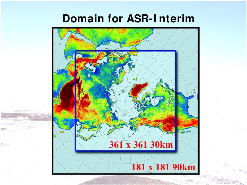
10 ASR-Interim 11 Year Data Assimilation Period: 2000~ 2010 Reduced Resolution: 30km-90km/71L, 10mb top ERA-Interim reanalysis model level data as BC and LB Full 3-hourly cycling run on OSC supercomputers Polar WRF (V3.3.1), WRF-Var (V3.3.1) and HRLDAS are used for the data assimilations.
, WRF-Var (V3.3.1) and HRLDAS are used for the data assimilations.")
11 Domain for ASR-Interim
12 Near Surface Variable Statistics The data used for the surface statistics: ERA-Interim Surface stations (More than 5000 obtained from the National Climatic Data Center (NCDC) and Greenland Climate Network (GC-NET))
 and Greenland Climate Network")
13 Average statistics from comparing ASR-Interim and ERA-Interim with observations for Name 10m Wind Speed 2m-Temperature 2m-Dew point Surface pressure bias rmse corr bias rmse corr bias rmse corr bias rmse corr ASR ERA

14 Average statistics from comparing ERA-Interim (ERA) and ASR-Interim (ASR) with observations for m Wind Speed RMSE 10m Wind Speed Correlation ERA ASR ERA ASR

15 Average statistics from comparing ERA-Interim (ERA) and ASR-Interim (ASR) with observations for m-temperature RMSE 2m-temperature Correlation ERA ASR 2.3 ERA ASR

16 Average statistics from comparing ERA-Interim (ERA) and ASR-Interim (ASR) with observations for m-Dew point RMSE ERA ASR m-Dew point Correlation ERA ASR

17 Average statistics from comparing ERA-Interim (ERA) and ASR-Interim (ASR) with observations for Surface Pressure RMSE Surface Pressure Correlation 1.15 ERA ASR ERA ASR

18 ASR Data Assimilation Result between ASR-Interim (ERA-Interim) assimilation and observations ASR Preliminary Meeting

19 ASR Data Assimilation Result between ASR-Interim (ERA-Interim) assimilation and observations ASR Preliminary Meeting

20 ASR Data Assimilation Result: Polar Low 10 m Wind and Satellite Image 06 h DEC 20, 2007 ASR Preliminary Meeting

21 ASR Data Assimilation Result: Polar Low 10 m Wind and Satellite Image ASR-Interim ERA-Interim 03h Mar 16, 2007 ASR Preliminary Meeting
22 ASR Data Assimilation Result: Polar Low 10 m Wind and Satellite Image 18h Jan 12, 2007 ASR Preliminary Meeting
23 09h Feb 02, 2010 ASR Data Assimilation Result: Arctic Weather System 10 m Wind
24 One-Month Cycling Run Results Precipitation (Monthly Total in August 2008, Unit: mm) ASR-Interim ASR Preliminary Meeting ERA-Interim
25 ASR Data Assimilation Result Precipitation ASR-Interim ERA-Interim ERA Yearly Total 2007, Unit: cm ASR Preliminary Meeting
26 Summary The ASR-Interim data assimilations with reduced resolution with nested grids (90 km outer domain; 30 km primary domain) have been performed from 2000 to 2010 at OSC. The results are very encouraging. Polar WRF, WRF-3DVar and Noah Land Data Assimilation will be updated to correct the bias in Q 2m, T 2m, precipitation and to improve ASR performance, and used for the final run. Based upon the ASR-Interim results and improvement of ASR system, the ASR team will perform 12 years ( ) at 10 km resolution. The target date for completion is September ASR data are distributed by NCAR's Research Data Archive and NOAA Earth System Research Laboratory (ESRL).
27 Average statistics from comparing ASR-Interim and ERA-Interim with observations for ASR Month 10m Wind Speed 2m-Temperature 2m-Dew point Surface pressure bias rmse corr bias rmse corr bias rmse corr bias rmse corr AVG ERAI Month 10m Wind Speed bias rmse corr 2m-Temperature bias rmse AVG ASR Preliminary Meeting corr 2m-Dew point bias rmse corr Surface pressure bias rmse corr
Titelmasterformat durch Klicken. bearbeiten
 Evaluation of a Fully Coupled Atmospheric Hydrological Modeling System for the Sissili Watershed in the West African Sudanian Savannah Titelmasterformat durch Klicken June, 11, 2014 1 st European Fully
High-resolution Regional Reanalyses for Europe and Germany
 High-resolution Regional Reanalyses for Europe and Germany Christian Ohlwein 1,2, Jan Keller 1,4, Petra Friederichs 2, Andreas Hense 2, Susanne Crewell 3, Sabrina Bentzien 1,2, Christoph Bollmeyer 1,2,
Application of Numerical Weather Prediction Models for Drought Monitoring. Gregor Gregorič Jožef Roškar Environmental Agency of Slovenia
 Application of Numerical Weather Prediction Models for Drought Monitoring Gregor Gregorič Jožef Roškar Environmental Agency of Slovenia Contents 1. Introduction 2. Numerical Weather Prediction Models -
Jessica Blunden, Ph.D., Scientist, ERT Inc., Climate Monitoring Branch, NOAA s National Climatic Data Center
 Kathryn Sullivan, Ph.D, Acting Under Secretary of Commerce for Oceans and Atmosphere and NOAA Administrator Thomas R. Karl, L.H.D., Director,, and Chair of the Subcommittee on Global Change Research Jessica
Validation n 2 of the Wind Data Generator (WDG) software performance. Comparison with measured mast data - Flat site in Northern France
 software performance. Comparison with measured mast data - Flat site in Northern France") Validation n 2 of the Wind Data Generator (WDG) software performance Comparison with measured mast data - Flat site in Northern France Mr. Tristan Fabre* La Compagnie du Vent, GDF-SUEZ, Montpellier, 34967,
Validation n 2 of the Wind Data Generator (WDG) software performance Comparison with measured mast data - Flat site in Northern France Mr. Tristan Fabre* La Compagnie du Vent, GDF-SUEZ, Montpellier, 34967,
REGIONAL CLIMATE AND DOWNSCALING
 REGIONAL CLIMATE AND DOWNSCALING Regional Climate Modelling at the Hungarian Meteorological Service ANDRÁS HORÁNYI (horanyi( [email protected]@met.hu) Special thanks: : Gabriella Csima,, Péter Szabó, Gabriella
Temporal variation in snow cover over sea ice in Antarctica using AMSR-E data product
 Temporal variation in snow cover over sea ice in Antarctica using AMSR-E data product Michael J. Lewis Ph.D. Student, Department of Earth and Environmental Science University of Texas at San Antonio ABSTRACT
Developing Continuous SCM/CRM Forcing Using NWP Products Constrained by ARM Observations
 Developing Continuous SCM/CRM Forcing Using NWP Products Constrained by ARM Observations S. C. Xie, R. T. Cederwall, and J. J. Yio Lawrence Livermore National Laboratory Livermore, California M. H. Zhang
IMPACT OF SAINT LOUIS UNIVERSITY-AMERENUE QUANTUM WEATHER PROJECT MESONET DATA ON WRF-ARW FORECASTS
 IMPACT OF SAINT LOUIS UNIVERSITY-AMERENUE QUANTUM WEATHER PROJECT MESONET DATA ON WRF-ARW FORECASTS M. J. Mueller, R. W. Pasken, W. Dannevik, T. P. Eichler Saint Louis University Department of Earth and
Development of an Integrated Data Product for Hawaii Climate
 Development of an Integrated Data Product for Hawaii Climate Jan Hafner, Shang-Ping Xie (PI)(IPRC/SOEST U. of Hawaii) Yi-Leng Chen (Co-I) (Meteorology Dept. Univ. of Hawaii) contribution Georgette Holmes
Real-time Ocean Forecasting Needs at NCEP National Weather Service
 Real-time Ocean Forecasting Needs at NCEP National Weather Service D.B. Rao NCEP Environmental Modeling Center December, 2005 HYCOM Annual Meeting, Miami, FL COMMERCE ENVIRONMENT STATE/LOCAL PLANNING HEALTH
Estimating Firn Emissivity, from 1994 to1998, at the Ski Hi Automatic Weather Station on the West Antarctic Ice Sheet Using Passive Microwave Data
 Estimating Firn Emissivity, from 1994 to1998, at the Ski Hi Automatic Weather Station on the West Antarctic Ice Sheet Using Passive Microwave Data Mentor: Dr. Malcolm LeCompte Elizabeth City State University
What the Heck are Low-Cloud Feedbacks? Takanobu Yamaguchi Rachel R. McCrary Anna B. Harper
 What the Heck are Low-Cloud Feedbacks? Takanobu Yamaguchi Rachel R. McCrary Anna B. Harper IPCC Cloud feedbacks remain the largest source of uncertainty. Roadmap 1. Low cloud primer 2. Radiation and low
ASSESSMENT OF THE CAPABILITY OF WRF MODEL TO ESTIMATE CLOUDS AT DIFFERENT TEMPORAL AND SPATIAL SCALES
 16TH WRF USER WORKSHOP, BOULDER, JUNE 2015 ASSESSMENT OF THE CAPABILITY OF WRF MODEL TO ESTIMATE CLOUDS AT DIFFERENT TEMPORAL AND SPATIAL SCALES Clara Arbizu-Barrena, David Pozo-Vázquez, José A. Ruiz-Arias,
Performance Analysis and Application of Ensemble Air Quality Forecast System in Shanghai
 Performance Analysis and Application of Ensemble Air Quality Forecast System in Shanghai Qian Wang 1, Qingyan Fu 1, Ping Liu 2, Zifa Wang 3, Tijian Wang 4 1.Shanghai environmental monitoring center 2.Shanghai
Cloud Correction and its Impact on Air Quality Simulations
 Cloud Correction and its Impact on Air Quality Simulations Arastoo Pour Biazar 1, Richard T. McNider 1, Andrew White 1, Bright Dornblaser 3, Kevin Doty 1, Maudood Khan 2 1. University of Alabama in Huntsville
Distributed Computing. Mark Govett Global Systems Division
 Distributed Computing Mark Govett Global Systems Division Modeling Activities Prediction & Research Weather forecasts, climate prediction, earth system science Observing Systems Denial experiments Observing
Clouds and the Energy Cycle
 August 1999 NF-207 The Earth Science Enterprise Series These articles discuss Earth's many dynamic processes and their interactions Clouds and the Energy Cycle he study of clouds, where they occur, and
Developing sub-domain verification methods based on Geographic Information System (GIS) tools
 tools") APPROVED FOR PUBLIC RELEASE: DISTRIBUTION UNLIMITED U.S. Army Research, Development and Engineering Command Developing sub-domain verification methods based on Geographic Information System (GIS) tools
APPROVED FOR PUBLIC RELEASE: DISTRIBUTION UNLIMITED U.S. Army Research, Development and Engineering Command Developing sub-domain verification methods based on Geographic Information System (GIS) tools
TOPIC: CLOUD CLASSIFICATION
 INDIAN INSTITUTE OF TECHNOLOGY, DELHI DEPARTMENT OF ATMOSPHERIC SCIENCE ASL720: Satellite Meteorology and Remote Sensing TERM PAPER TOPIC: CLOUD CLASSIFICATION Group Members: Anil Kumar (2010ME10649) Mayank
Project Title: Quantifying Uncertainties of High-Resolution WRF Modeling on Downslope Wind Forecasts in the Las Vegas Valley
 University: Florida Institute of Technology Name of University Researcher Preparing Report: Sen Chiao NWS Office: Las Vegas Name of NWS Researcher Preparing Report: Stanley Czyzyk Type of Project (Partners
Joint Polar Satellite System (JPSS)
") Joint Polar Satellite System (JPSS) John Furgerson, User Liaison Joint Polar Satellite System National Environmental Satellite, Data, and Information Service National Oceanic and Atmospheric Administration
Joint Polar Satellite System (JPSS) John Furgerson, User Liaison Joint Polar Satellite System National Environmental Satellite, Data, and Information Service National Oceanic and Atmospheric Administration
Baudouin Raoult, Iryna Rozum, Dick Dee
 ECMWF contribution to the EU funded CHARME Project: A Significant Event Viewer tool Matthew Manoussakis Baudouin Raoult, Iryna Rozum, Dick Dee 5th Workshop on the use of GIS/OGC standards in meteorology
Data Management Framework for the North American Carbon Program
 Data Management Framework for the North American Carbon Program Bob Cook, Peter Thornton, and the Steering Committee Image courtesy of NASA/GSFC NACP Data Management Planning Workshop New Orleans, LA January
New, Unique, and Dedicated dataset for the Global Atlas
 WFES 2014 EUDP Global Wind Atlas: New, Unique, and Dedicated dataset for the Global Atlas Presented by Jake Badger EUDP is a Danish fund for development and demonstration projects from the Danish Energy
The Surface Energy Budget
 The Surface Energy Budget The radiation (R) budget Shortwave (solar) Radiation Longwave Radiation R SW R SW α α = surface albedo R LW εσt 4 ε = emissivity σ = Stefan-Boltzman constant T = temperature Subsurface
Fundamentals of Climate Change (PCC 587): Water Vapor
: Water Vapor") Fundamentals of Climate Change (PCC 587): Water Vapor DARGAN M. W. FRIERSON UNIVERSITY OF WASHINGTON, DEPARTMENT OF ATMOSPHERIC SCIENCES DAY 2: 9/30/13 Water Water is a remarkable molecule Water vapor
Fundamentals of Climate Change (PCC 587): Water Vapor DARGAN M. W. FRIERSON UNIVERSITY OF WASHINGTON, DEPARTMENT OF ATMOSPHERIC SCIENCES DAY 2: 9/30/13 Water Water is a remarkable molecule Water vapor
Future needs of remote sensing science in Antarctica and the Southern Ocean: A report to support the Horizon Scan activity of COMNAP and SCAR
 Future needs of remote sensing science in Antarctica and the Southern Ocean: A report to support the Horizon Scan activity of COMNAP and SCAR Thomas Wagner ([email protected]) Charles Webb NASA Cryospheric
Data Sets of Climate Science
 The 5 Most Important Data Sets of Climate Science Photo: S. Rahmstorf This presentation was prepared on the occasion of the Arctic Expedition for Climate Action, July 2008. Author: Stefan Rahmstorf, Professor
Radiative effects of clouds, ice sheet and sea ice in the Antarctic
 Snow and fee Covers: Interactions with the Atmosphere and Ecosystems (Proceedings of Yokohama Symposia J2 and J5, July 1993). IAHS Publ. no. 223, 1994. 29 Radiative effects of clouds, ice sheet and sea
Cloud/Hydrometeor Initialization in the 20-km RUC Using GOES Data
 WORLD METEOROLOGICAL ORGANIZATION COMMISSION FOR BASIC SYSTEMS OPEN PROGRAMMME AREA GROUP ON INTEGRATED OBSERVING SYSTEMS EXPERT TEAM ON OBSERVATIONAL DATA REQUIREMENTS AND REDESIGN OF THE GLOBAL OBSERVING
Towards an NWP-testbed
 Towards an NWP-testbed Ewan O Connor and Robin Hogan University of Reading, UK Overview Cloud schemes in NWP models are basically the same as in climate models, but easier to evaluate using ARM because:
NASA Earth System Science: Structure and data centers
 SUPPLEMENT MATERIALS NASA Earth System Science: Structure and data centers NASA http://nasa.gov/ NASA Mission Directorates Aeronautics Research Exploration Systems Science http://nasascience.nasa.gov/
NCDC s SATELLITE DATA, PRODUCTS, and SERVICES
 **** NCDC s SATELLITE DATA, PRODUCTS, and SERVICES Satellite data and derived products from NOAA s satellite systems are available through the National Climatic Data Center. The two primary systems are
Huai-Min Zhang & NOAAGlobalTemp Team
 Improving Global Observations for Climate Change Monitoring using Global Surface Temperature (& beyond) Huai-Min Zhang & NOAAGlobalTemp Team NOAA National Centers for Environmental Information (NCEI) [formerly:
Satellite'&'NASA'Data'Intro'
 Satellite'&'NASA'Data'Intro' Research'vs.'Opera8ons' NASA':'Research'satellites' ' ' NOAA/DoD:'Opera8onal'Satellites' NOAA'Polar'Program:'NOAA>16,17,18,19,NPP' Geosta8onary:'GOES>east,'GOES>West' DMSP'series:'SSM/I,'SSMIS'
Cloud Model Verification at the Air Force Weather Agency
 2d Weather Group Cloud Model Verification at the Air Force Weather Agency Matthew Sittel UCAR Visiting Scientist Air Force Weather Agency Offutt AFB, NE Template: 28 Feb 06 Overview Cloud Models Ground
The Wind Integration National Dataset (WIND) toolkit
 toolkit") The Wind Integration National Dataset (WIND) toolkit EWEA Wind Power Forecasting Workshop, Rotterdam December 3, 2013 Caroline Draxl NREL/PR-5000-60977 NREL is a national laboratory of the U.S. Department
The Wind Integration National Dataset (WIND) toolkit EWEA Wind Power Forecasting Workshop, Rotterdam December 3, 2013 Caroline Draxl NREL/PR-5000-60977 NREL is a national laboratory of the U.S. Department
Armenian State Hydrometeorological and Monitoring Service
 Armenian State Hydrometeorological and Monitoring Service Offenbach 1 Armenia: IN BRIEF Armenia is located in Southern Caucasus region, bordering with Iran, Azerbaijan, Georgia and Turkey. The total territory
USING SIMULATED WIND DATA FROM A MESOSCALE MODEL IN MCP. M. Taylor J. Freedman K. Waight M. Brower
 USING SIMULATED WIND DATA FROM A MESOSCALE MODEL IN MCP M. Taylor J. Freedman K. Waight M. Brower Page 2 ABSTRACT Since field measurement campaigns for proposed wind projects typically last no more than
Comparison of the Vertical Velocity used to Calculate the Cloud Droplet Number Concentration in a Cloud-Resolving and a Global Climate Model
 Comparison of the Vertical Velocity used to Calculate the Cloud Droplet Number Concentration in a Cloud-Resolving and a Global Climate Model H. Guo, J. E. Penner, M. Herzog, and X. Liu Department of Atmospheric,
Real-time and Archived Antarctic. Interactive Processing Tools
 Real-time and Archived Antarctic Meteorological Data via a Synergy of Interactive Processing Tools Mark W. Seefeldt Department of Atmospheric and Oceanic Sciences University it of Colorado at Boulder,
GCOS science conference, 2 Mar. 2016, Amsterdam. Japan Meteorological Agency (JMA)
") GCOS science conference, 2 Mar. 2016, Amsterdam Status of Surface Radiation Budget Observation for Climate Nozomu Ohkawara Japan Meteorological Agency (JMA) Contents 1. Background 2. Status t of surface
GCOS science conference, 2 Mar. 2016, Amsterdam Status of Surface Radiation Budget Observation for Climate Nozomu Ohkawara Japan Meteorological Agency (JMA) Contents 1. Background 2. Status t of surface
Observed Cloud Cover Trends and Global Climate Change. Joel Norris Scripps Institution of Oceanography
 Observed Cloud Cover Trends and Global Climate Change Joel Norris Scripps Institution of Oceanography Increasing Global Temperature from www.giss.nasa.gov Increasing Greenhouse Gases from ess.geology.ufl.edu
Simulations of Clouds and Sensitivity Study by Wearther Research and Forecast Model for Atmospheric Radiation Measurement Case 4
 Simulations of Clouds and Sensitivity Study by Wearther Research and Forecast Model for Atmospheric Radiation Measurement Case 4 Jingbo Wu and Minghua Zhang Institute for Terrestrial and Planetary Atmospheres
IMPACTS OF IN SITU AND ADDITIONAL SATELLITE DATA ON THE ACCURACY OF A SEA-SURFACE TEMPERATURE ANALYSIS FOR CLIMATE
 INTERNATIONAL JOURNAL OF CLIMATOLOGY Int. J. Climatol. 25: 857 864 (25) Published online in Wiley InterScience (www.interscience.wiley.com). DOI:.2/joc.68 IMPACTS OF IN SITU AND ADDITIONAL SATELLITE DATA
Analysis of Climatic and Environmental Changes Using CLEARS Web-GIS Information-Computational System: Siberia Case Study
 Analysis of Climatic and Environmental Changes Using CLEARS Web-GIS Information-Computational System: Siberia Case Study A G Titov 1,2, E P Gordov 1,2, I G Okladnikov 1,2, T M Shulgina 1 1 Institute of
Cloud-Resolving Simulations of Convection during DYNAMO
 Cloud-Resolving Simulations of Convection during DYNAMO Matthew A. Janiga and Chidong Zhang University of Miami, RSMAS 2013 Fall ASR Workshop Outline Overview of observations. Methodology. Simulation results.
Meteorological Forecasting of DNI, clouds and aerosols
 Meteorological Forecasting of DNI, clouds and aerosols DNICast 1st End-User Workshop, Madrid, 2014-05-07 Heiner Körnich (SMHI), Jan Remund (Meteotest), Marion Schroedter-Homscheidt (DLR) Overview What
Long term cloud cover trends over the U.S. from ground based data and satellite products
 Long term cloud cover trends over the U.S. from ground based data and satellite products Hye Lim Yoo 12 Melissa Free 1, Bomin Sun 34 1 NOAA Air Resources Laboratory, College Park, MD, USA 2 Cooperative
Simulation of low clouds from the CAM and the regional WRF with multiple nested resolutions
 Click Here for Full Article GEOPHYSICAL RESEARCH LETTERS, VOL. 36, L08813, doi:10.1029/2008gl037088, 2009 Simulation of low clouds from the CAM and the regional WRF with multiple nested resolutions Wuyin
1D shallow convective case studies and comparisons with LES
 1D shallow convective case studies and comparisons with CNRM/GMME/Méso-NH 24 novembre 2005 1 / 17 Contents 1 5h-6h time average vertical profils 2 2 / 17 Case description 5h-6h time average vertical profils
Climatology and Monitoring of Dust and Sand Storms in the Arabian Peninsula
 Climatology and Monitoring of Dust and Sand Storms in the Arabian Peninsula Mansour Almazroui Center of Excellence for Climate Change Research (CECCR) King Abdulaziz University, Jeddah, Saudi Arabia E-mail:
Monsoon Variability and Extreme Weather Events
 Monsoon Variability and Extreme Weather Events M Rajeevan National Climate Centre India Meteorological Department Pune 411 005 [email protected] Outline of the presentation Monsoon rainfall Variability
Evaluation of precipitation simulated over mid-latitude land by CPTEC AGCM single-column model
 Evaluation of precipitation simulated over mid-latitude land by CPTEC AGCM single-column model Enver Ramírez Gutiérrez 1, Silvio Nilo Figueroa 2, Paulo Kubota 2 1 CCST, 2 CPTEC INPE Cachoeira Paulista,
PART 1. Representations of atmospheric phenomena
 PART 1 Representations of atmospheric phenomena Atmospheric data meet all of the criteria for big data : they are large (high volume), generated or captured frequently (high velocity), and represent a
Mode-S Enhanced Surveillance derived observations from multiple Air Traffic Control Radars and the impact in hourly HIRLAM
 Mode-S Enhanced Surveillance derived observations from multiple Air Traffic Control Radars and the impact in hourly HIRLAM 1 Introduction Upper air wind is one of the most important parameters to obtain
Validation of ECMWF and NCEP NCAR Reanalysis Data in Antarctica
 ADVANCES IN ATMOSPHERIC SCIENCES, VOL. 27, NO. 5, 2010, 1151 1168 Validation of ECMWF and NCEP NCAR Reanalysis Data in Antarctica YU Lejiang 1 (ÙÏ), ZHANG Zhanhai 1 ( ), ZHOU Mingyu 1 ( ), Shiyuan ZHONG
II. Related Activities
 (1) Global Cloud Resolving Model Simulations toward Numerical Weather Forecasting in the Tropics (FY2005-2010) (2) Scale Interaction and Large-Scale Variation of the Ocean Circulation (FY2006-2011) (3)
REDUCING UNCERTAINTY IN SOLAR ENERGY ESTIMATES
 REDUCING UNCERTAINTY IN SOLAR ENERGY ESTIMATES Mitigating Energy Risk through On-Site Monitoring Marie Schnitzer, Vice President of Consulting Services Christopher Thuman, Senior Meteorologist Peter Johnson,
Long-term Observations of the Convective Boundary Layer (CBL) and Shallow cumulus Clouds using Cloud Radar at the SGP ARM Climate Research Facility
 and Shallow cumulus Clouds using Cloud Radar at the SGP ARM Climate Research Facility") Long-term Observations of the Convective Boundary Layer (CBL) and Shallow cumulus Clouds using Cloud Radar at the SGP ARM Climate Research Facility Arunchandra S. Chandra Pavlos Kollias Department of Atmospheric
Long-term Observations of the Convective Boundary Layer (CBL) and Shallow cumulus Clouds using Cloud Radar at the SGP ARM Climate Research Facility Arunchandra S. Chandra Pavlos Kollias Department of Atmospheric
A Description of the 2nd Generation NOAA Global Ensemble Reforecast Data Set
 A Description of the 2nd Generation NOAA Global Ensemble Reforecast Data Set Table of contents: produced by the NOAA Earth System Research Lab, Physical Sciences Division Boulder, Colorado USA under a
Atmospheric Dynamics of Venus and Earth. Institute of Geophysics and Planetary Physics UCLA 2 Lawrence Livermore National Laboratory
 Atmospheric Dynamics of Venus and Earth G. Schubert 1 and C. Covey 2 1 Department of Earth and Space Sciences Institute of Geophysics and Planetary Physics UCLA 2 Lawrence Livermore National Laboratory
Estimation of satellite observations bias correction for limited area model
 Estimation of satellite observations bias correction for limited area model Roger Randriamampianina Hungarian Meteorological Service, Budapest, Hungary [email protected] Abstract Assimilation of satellite radiances
CERES Edition 2 & Edition 3 Cloud Cover, Cloud Altitude and Temperature
 CERES Edition 2 & Edition 3 Cloud Cover, Cloud Altitude and Temperature S. Sun-Mack 1, P. Minnis 2, Y. Chen 1, R. Smith 1, Q. Z. Trepte 1, F. -L. Chang, D. Winker 2 (1) SSAI, Hampton, VA (2) NASA Langley
Satellite SST Product Development Proposal
 Call for Proposals under the IMOS (EIF) Five Year Strategy: Enhancement or extension of IMOS July 2009 to June 2013 Satellite SST Products Sub-Facility Plan Overview: Proposed Infrastructure Investment:
SOLAR IRRADIANCE FORECASTING, BENCHMARKING of DIFFERENT TECHNIQUES and APPLICATIONS of ENERGY METEOROLOGY
 SOLAR IRRADIANCE FORECASTING, BENCHMARKING of DIFFERENT TECHNIQUES and APPLICATIONS of ENERGY METEOROLOGY Wolfgang Traunmüller 1 * and Gerald Steinmaurer 2 1 BLUE SKY Wetteranalysen, 4800 Attnang-Puchheim,
The Arctic Observing Network and its Data Management Challenges Florence Fetterer (NSIDC/CIRES/CU), James A. Moore (NCAR/EOL), and the CADIS team
, James A. Moore (NCAR/EOL), and the CADIS team") The Arctic Observing Network and its Data Management Challenges Florence Fetterer (NSIDC/CIRES/CU), James A. Moore (NCAR/EOL), and the CADIS team Photo courtesy Andrew Mahoney NSF Vision What is AON? a
The Arctic Observing Network and its Data Management Challenges Florence Fetterer (NSIDC/CIRES/CU), James A. Moore (NCAR/EOL), and the CADIS team Photo courtesy Andrew Mahoney NSF Vision What is AON? a
Report to 8 th session of OOPC. By Dr. Alan R. Thomas, Director, GCOS Secretariat
 Report to 8 th session of OOPC By Dr. Alan R. Thomas, Director, GCOS Secretariat The GCOS is comprised of the climate components of the domain based observing systems including both satellite and in situ
AMS 2009 Summer Community Meeting Renewable Energy Topic
 AMS 2009 Summer Community Meeting Renewable Energy Topic The 2009 American Meteorological Society s Summer Community Meeting addressed the roles of academia, industry and government in supporting the development
Application of global 1-degree data sets to simulate runoff from MOPEX experimental river basins
 18 Large Sample Basin Experiments for Hydrological Model Parameterization: Results of the Model Parameter Experiment. IAHS Publ. 37, 26. Application of global 1-degree data sets to simulate from experimental
Daily High-resolution Blended Analyses for Sea Surface Temperature
 Daily High-resolution Blended Analyses for Sea Surface Temperature by Richard W. Reynolds 1, Thomas M. Smith 2, Chunying Liu 1, Dudley B. Chelton 3, Kenneth S. Casey 4, and Michael G. Schlax 3 1 NOAA National
Data Management for the North American Carbon Program
 Image courtesy of NASA/GSFC Data Management for the North American Carbon Program Bob Cook, Eric Sundquist, Tom Boden,, and Peter Thornton RS in NACP Workshop Missoula, MT August 20, 2004 NACP Data and
Comparative Evaluation of High Resolution Numerical Weather Prediction Models COSMO-WRF
 3 Working Group on Verification and Case Studies 56 Comparative Evaluation of High Resolution Numerical Weather Prediction Models COSMO-WRF Bogdan Alexandru MACO, Mihaela BOGDAN, Amalia IRIZA, Cosmin Dănuţ
Near Real Time Blended Surface Winds
 Near Real Time Blended Surface Winds I. Summary To enhance the spatial and temporal resolutions of surface wind, the remotely sensed retrievals are blended to the operational ECMWF wind analyses over the
A SURVEY OF CLOUD COVER OVER MĂGURELE, ROMANIA, USING CEILOMETER AND SATELLITE DATA
 Romanian Reports in Physics, Vol. 66, No. 3, P. 812 822, 2014 ATMOSPHERE PHYSICS A SURVEY OF CLOUD COVER OVER MĂGURELE, ROMANIA, USING CEILOMETER AND SATELLITE DATA S. STEFAN, I. UNGUREANU, C. GRIGORAS
Mapping of Antarctic sea ice in the depletion phase: an indicator of climatic change?
 Mapping of Antarctic sea ice in the depletion phase: an indicator of climatic change? G. Sreenivasan 1 and T. J. Majumdar 2, * 1 Regional Remote Sensing Service Centre, Nagpur 440 010, India 2 Space Applications