Commercial Internet Mapping Impacts on Government Investments in GIS. Wansoo Im, Ph.D. VERTICES, LLC New Brunswick, NJ
|
|
|
- Adelia Black
- 8 years ago
- Views:
Transcription
1 Commercial Internet Mapping Impacts on Government Investments in GIS Wansoo Im, Ph.D. VERTICES, LLC New Brunswick, NJ

2 Acknowledgements: Research funded by the Korean Land Spatialization Group Principal Investigators: Wansoo Im, VERTICES, LLC. Twyla McDermott, City of Charlotte

3 Presentation Overview Government Sector SDI investments Current Initiatives & Market Forces Interoperability Data Sharing Standards FOSS: Free and Open Source Software The advent of commercial APIs Public Expectations Ubiquitous Nature Ease of operations Investment Impacts: Survey Results Research Horizon Questions & Discussion

4 Commercial Internet applications like Google Maps, Google Earth and Microsoft Virtual Earth are having a significant impact on the GIS industry by exposing the power of spatial data to the general public through their friendly user interfaces and easily accessible application programming interfaces (API).

5 How we defined Commercial Internet Mapping in this presentation Providing Map Services (designing, implementing, generating, and delivering maps) via World Wide Web Free Web Mapping Service Application provide by Commercial Companies Satellite View Street View Extensibility and Customization via API Such as Google Maps & Google Earth, Microsoft Virtual Earth and others

6 Our research focused on how these open map API technologies affect government investments in geospatial data development and geospatial services. - An online survey of agencies representing various North American governmental sectors (federal, state/provincial, county, municipal and agency levels) was conducted -

7 Government Sector Investments in the National Spatial Data Infrastructure Federal Government Land Registry Census State Governments Natural Resource Inventories Local Governments Tax Assessment Orthoimagery Addresses for E-911 Other Regional Governments Planning Disaster Preparedness, Response & Recovery

8 What is Happening in the Government GIS Sector Interoperability Interoperability Interoperability Interoperability

9 North Carolina: NC ONE Map

10 For example, Benefits of NCOneMap Access through one location to the most up-to-date geospatial data Instant availability of multi-jurisdictional data Data distribution costs lessened for participating governments Public investment leveraged for maximum effect More than one million dollars in cost-shares for local government orthoimagery Focus on common data framework and standards Forum for the NC GIS community to raise issues and solve problems together from NCOneMap website

11 USGS Geography: The National Map

12 Commercial Internet Map APIs: Google Maps/Google Earth & Microsoft Virtual Earth Seamless area coverage Availability of NSDI Layers: Streets Orthoimagery Other Spatial data Access to GIS functionality Fast & reliable Familiar, user-friendly interface And it s free!

13 Examples of Open Map APIs at the Government National Geospatial-Intelligence Agency (NGA) Images copied from
 Images copied from")
14 New Jersey Point of Interest (NJPOI)
")
15

16

17

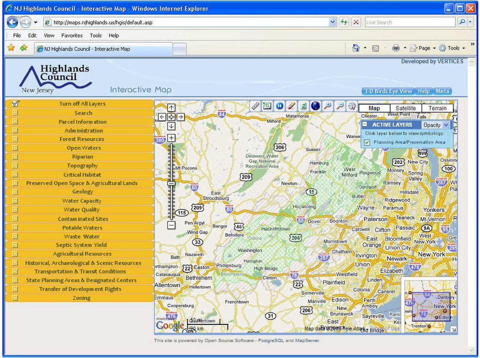
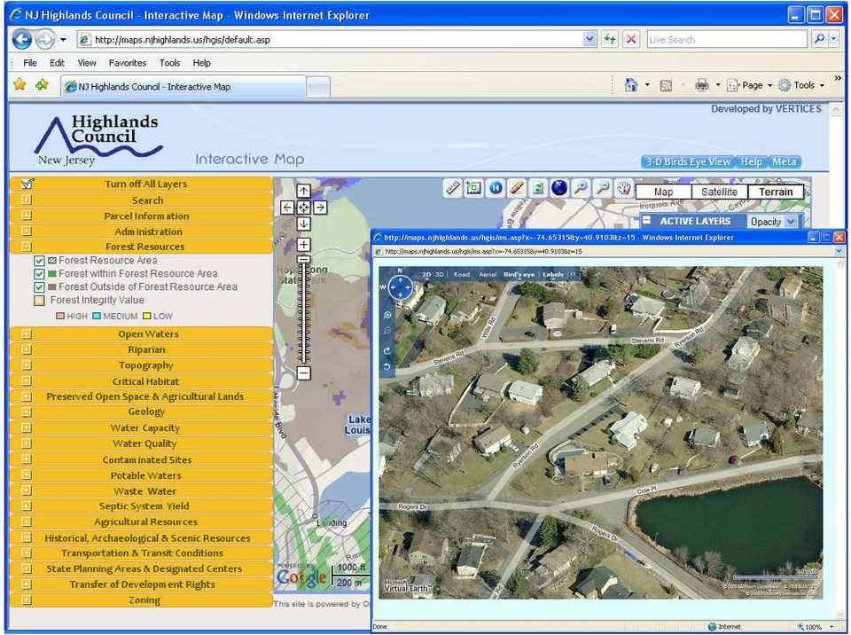
18 New Jersey Highlands Council Interactive Maps

19
20
21
22 Bedminster Township, New Jersey Easement section
23
24 Application Development Based Based on on Interoperability Google Map USGS Microsoft Virtual Map NOAA WebGIS Application Via Interoperability User Created Content USEPA Local Government
25 Survey on Commercial Internet Mapping Impacts on Government GIS Data Development and Services Online Survey Conducted June 2008 Distributed to URISA members and other GIS professionals 310 Responded 97.7% were currently employed as permanent or contract staff 1.3% were recently employed (within past 6 months) 1.0% (none of the above -didn t fill out the remainder of the survey)
26 Distribution of Survey Respondents
27 Organization Type
28 Survey Respondent Position Response Percent Chief Information Officer 0.3 % IT Manager/Director 4.0 % GIS Manager/Director/Geographic Information Officer 32.7 % GIS Coordinator 19.5 % GIS Analyst/GIS Specialist/ Senior GIS Analysts 21.9 % GIS Programmer/Programmer Analyst 3.0 % GIS Database Administrator 1.3 % Business Analyst/Management Analyst 1.0 % GIS Technician/Cartographer/Mapping Specialist/Address Specialist 5.1 % Cadastral Map Specialist/Land Records Map Specialist 0.7 % Other(s) 10.4 %
29 Role and scope of daily work activities Response Percent Mapping and Analysis 78.9 % GIS Application Development, including web-based mapping 51.8 % GIS Project Management 76.9 % GIS Program Management 62.5 % Strategic Planning 61.9 % Database Maintenance (i.e. addresses, cadastral maps, etc.) 67.2 % Staff Supervision 55.5 % Budgeting and Financial Management 50.5 % Standards Development 61.2 % Policy Development 57.9 %
30 Are street or imagery data used in your organization?
31 How do you obtain your street and imagery data?
32 Do you have a data sharing arrangement of any nature that involves streets and/or imagery data? Consortium of regional municipalities/agencies Data/cost sharing with multiple levels of government Data/cost sharing with other types of organizations e.g. school district Adjoining counties/municipalities Contract with commercial data companies (Navtec, Teleatlas) Provide data for free
33 How often are your street and imagery data updated? Street Imagery Daily 27.9% 0.6% Weekly 7.8% 0.0% Monthly 14.5% 0.0% Quarterly 8.4% 0.0% Yearly 16.8% 22.7% Every two years 3.9% 31.5% More than two years 2.2% 34.8% As needed 18.4% 10.5%
34 What are costs associated with your data in cost per cycle (in USD)? Average Amount Median Amount Streets (Initial Investment) $ 89,000 $ 39,000 Streets (Recurring Maintenance or Licensing) $ 36,000 $ 15,000 Imagery (Initial Investment) $ 1,879,000 $ 127,500 Imagery (recurring maintenance or Licensing) $ 96,000 $ 37,500
35 How is your street and imagery data funded? Street Imagery General Fund 46.0% 31.1% Grants 2.9% 3.4% Revenue Fund 4.4% 5.4% Shared 4.4% 8.8% Combined (at least two from above) 9.5% 19.6% Free 2.9% 2.0% Others 29.9% 29.7%
36 How do you disseminate or share your digital GIS data? (Check all that apply) Response Percent Upon request as digital files, such as DVD, CD, hard drive, etc % Downloads from website or FTP site 58.4 % Views via Internet mapping application(s) 47.8 % Do not distribute digital data 5.3 % Other(s) 9.7 %
37 Do you provide web-based GIS applications? Examples of web-based GIS applications include tax property information look-ups and voting precinct identification via a map interface.
38 For the web-based applications your agency has implemented, please specify: the application type(s) and who the users of the systems are. Public Safety (Police, Fire, Homeland Security, etc.) Environment (Water Quality, Air Quality, Park& Recreation, etc.) Internal Staff Use Only External Selected Users (requires login) External General Public Users Response Count 78.3 % 13.8 % 35.5 % 100 % (138) 64.8 % 14.8 % 69.5 % 100 % (128) Real Property Ownership 67.2 % 17.8 % 68.9 % 100 % (180) Transportation 68.3 % 12.9 % 66.9 % 100 % (139) Land Development 68.3 % 12.9 % 66.9 % 100 % (138) Inspections and Permits 72.5 % 18.1 % 65.2 % 100 % (100) Capital Projects 80.0 % 19.0 % 39.0 % 100 % (71) Public Works (Utilities) 85.9 % 9.9 % 43.7 % 100 % (121) Economic Development 71.7 % 12.0 % 60.9 % 100 % (92) Voting: Precincts and/or Election Results Reporting 63.4 % 14.6 % 84.1 % 100 % (82) Other(s) 63.2 % 14.6 % 84.1 % 100 % (57)
39 Please identify the technology platform(s) for your webbased application in terms of software components (such as ESRI ArcGIS Server, Google Maps API, etc.)
40 What kinds of spatial database are you using for your Internet mapping?
41 How do you host your web-based GIS applications?
42 By whom was your Internet mapping application developed (or will be developed)?
43 Please indicate the factors that led to the solution approach.
44 Please indicate the tangible benefits for your webbased applications (i.e. improvements that can be measured or quantified in terms of cost or time).
45 Were there specific technical and organizational challenges either during development, implementation or after going-live?
46 Do you currently use Google Maps API (Google Earth) or MS Virtual Earth API or plan to implement these in the future?
47 If you use publicly available GIS Internet applications like Google Maps/Earth and/or Microsoft Virtual Earth, do you have a data sharing agreement with Google or Microsoft?
48 If you answered yes to the previous question, why did your organization enter into a data sharing agreement with Google and/or Microsoft?
49 If you either plan or currently use publicly available map APIs, please indicate why this choice was made.
50 If you either plan or currently use publicly available map APIs, please tell us what kinds of map APIs you are using or planning to use.
51 How are you planning to integrate the map API with your GIS data?
52 If you currently integrate data from your GIS server or image server with a map API (also known as a Hybrid Model), what kinds of technology do you use?
53 Has the advent of publicly available Internet map APIs like Google Maps/MS Virtual Earth affected the direction of GIS investments for data, visualization and dissemination? Getting a few less map requests than used to due to Google Maps User expectations and skill level is based on internet maps Our customers really don t understand what it takes to create geospatial applications It has changed the way we look at user interaction with the site It has increased the demand for web-based mapping services and applications
54 My boss has indicated that it has made it difficult to acquire funds for imagery because the powers that be see the imagery on Google Earth and think that is good enough. - from a survey respondent
55 Please select any concerns/risks associated with the use of a publicly available Internet map API (i.e. Google Maps/Google Earth or Microsoft Virtual Earth). Response Percent Data is not current (streets and imagery) 72.7 % Possible advertisement placement 46.0 % Limitations related to application functionality/development 44.7 % Uncertainty related to consistent services 41.3 % Security Licensing 31.3 % Perspective of upper management that web-based mapping is fast and easy Existing (previous) investment in commercial Web Service GIS technology 30.0 % 25.3 % Other(s) 18.7 %
56 What Does it Mean to GIS Professionals? It has increased the demand for web-based mapping services and applications. Users now expect fast and easy to use interactive maps with access to high quality - high resolution data. Its a challenge and a tremendous opportunity. The GIS Profession needs to embrace this new paradigm. It will ultimately create more demand for the data that drives these systems, and will result in the development of better applications to solve real-world problems. - from a survey respondent
57 Conclusions * Cooperation and synergy expected between commercial Internet map service providers and the public sector with data development, data sharing and service provision. * Government agencies realize they can extend their capacity for providing Internet map services with using the infrastructure of commercial Internet map services. * A growth in the number and type of applications that are hybrids that combine government GIS investments in data and web services with Open Map API services is projected.
58 Thank you! Contact: Wansoo Im, Ph.D. (VERTICES, NJ): Twyla McDermott (City of Charlotte, NC): Acknowledgement : This research was supported by a grant(07klsgc02) from Cutting-edge Urban Development - Korean Land Spatialization Research Project funded by Ministry of Land, Transport and Maritime Affairs We thank URISA for distributing the survey, as well as those URISA members who provided us with helpful feedback, especially Michael Waltuch and Mary Tsui.
ArcGIS Framework Plug-In: Extending the ArcGIS Desktop for ANSI Standard Framework Data to Support Government Decision Making
 ArcGIS Framework Plug-In: Extending the ArcGIS Desktop for ANSI Standard Framework Data to Support Government Decision Making Final Project Report October 28, 2008 Agreement Number Organization Project
Homeland Security Infrastructure Program HSIP Gold 2012 September 2012
 Homeland Security Infrastructure Program HSIP Gold 2012 September 2012 George Thomas, Chief, Content & Knowledge Management Division (PDC) IWG-Readiness, Response & Recovery (IWG-R3) George.J.Thomass@nga.mil,
Best Practices for Developing Geographic Information Models
 Urban and Regional Information Systems Association 1460 Renaissance Dr., Suite 305 Park Ridge, IL 60068 (847) 824-6300 Best Practices for Developing URISA Certified Workshop August 2007 Dr. David K. Arctur,
Texas Develops Online Geospatial Data Repository to Support Emergency Management
 Bing Maps for Enterprise Microsoft Customer Solution Case Study Texas Develops Online Geospatial Data Repository to Support Emergency Management Overview Country or Region: United States Industry: Government
Oregon Elevation Framework Implementation Team (E-FIT) Draft Charter and Bylaws 8/28/2014
 Draft Charter and Bylaws 8/28/2014") Oregon Elevation Framework Implementation Team (E-FIT) Draft Charter and Bylaws 8/28/2014 Adopted by OGIC, September 19, 2014 ARTICLE I. Name & Duration This Team, established by the State Framework Implementation
Oregon Elevation Framework Implementation Team (E-FIT) Draft Charter and Bylaws 8/28/2014 Adopted by OGIC, September 19, 2014 ARTICLE I. Name & Duration This Team, established by the State Framework Implementation
GIS Initiative: Developing an atmospheric data model for GIS. Olga Wilhelmi (ESIG), Jennifer Boehnert (RAP/ESIG) and Terri Betancourt (RAP)
, Jennifer Boehnert (RAP/ESIG) and Terri Betancourt (RAP)") GIS Initiative: Developing an atmospheric data model for GIS Olga Wilhelmi (ESIG), Jennifer Boehnert (RAP/ESIG) and Terri Betancourt (RAP) Unidata seminar August 30, 2004 Presentation Outline Overview
GIS Initiative: Developing an atmospheric data model for GIS Olga Wilhelmi (ESIG), Jennifer Boehnert (RAP/ESIG) and Terri Betancourt (RAP) Unidata seminar August 30, 2004 Presentation Outline Overview
Geo-information in The Hague & National SDI hub PDOK
 Geo-information in The Hague & National SDI hub PDOK dr.ir. Friso Penninga senior advisor at Municipality of The Hague & tactical advisor at Geonovum Contents 1. Introduction 2. GI in The Hague a. Overview
PDOK Kaart, the Dutch Mapping API
 PDOK Kaart, the Dutch Mapping API Haico van der Vegt*, Leo van der Sluijs* * Cadastre, Land Registry and Mapping Agency of the Netherlands Abstract. PDOK (public services on the map) is a partnership of
Geospatially Enabling the World: The Convergence of Geospatial and Architectural and Engineering Design
 Geospatially Enabling the World: The Convergence of Geospatial and Architectural and Engineering Design Geoff Zeiss Director of Technology Autodesk Map Middle East Dubai 2007 1 Overview Geospatial inflection
GIS Incident Management System for City of Philadelphia Emergency Operations Center
 GIS Incident Management System for City of Philadelphia Emergency Operations Center ESRI Mid-Atlantic Users Group Conference December 2 nd 2014 Presented by: Andrew Smart, GISP Who we are Full Service
Strategy for Improving Cadastral Spatial Quality toward Effective e- Government based NSDI
 Strategy for Improving Cadastral Spatial Quality toward Effective e- Government based NSDI Young-ho LEE, Republic of Korea Key words: e-government, interoperability, NSDI, Spatial quality SUMMARY E-Government
Mapping Mashup/Data Integration Development Resources Teaching with Google Earth and Google Ocean Stone Lab August 13, 2010
 Mapping Mashup/Data Integration Development Resources Teaching with Google Earth and Google Ocean Stone Lab August 13, 2010 David Hart GIS Specialist University of Wisconsin Sea Grant Institute Virtual
BC Community Health Atlas An interactive mapping tool for population health data
 An interactive mapping tool for population health data Rita Zhang, MPH Epidemiologist Population & Public Health Program Provincial Health Services Authority Bob Nicholson, MA Business Analyst Strategic
There are various ways to find data using the Hennepin County GIS Open Data site:
 Finding Data There are various ways to find data using the Hennepin County GIS Open Data site: Type in a subject or keyword in the search bar at the top of the page and press the Enter key or click the
Frequency of Geospatial Data Capture
 North Carolina Geospatial Data Archiving Project Frequency of Geospatial Data Capture conducted by NC Center for Geographic Information & Analysis Under a Partnership with The Library of Congress National
Data Fusion Centers. Transforming Public Safety Information into Actionable Knowledge
 Data Fusion Centers Transforming Public Safety Information into Actionable Knowledge Defining Geospatial Data Fusion Homeland security relies on fusion the ability to capture and analyze data from multiple
Next Generation Archives: The NC Geospatial Data Archiving Project
 Next Generation Archives: The NC Geospatial Data Archiving Project Jeff Essic North Carolina State University Libraries Zsolt Nagy North Carolina Center for Geographic Information and Analysis Coastal
Technology Trends In Geoinformation
 Technology Trends In Geoinformation Dato Prof. Sr Dr. Abdul Kadir Bin Taib Department of Survey and Mapping Malaysia (JUPEM) Email: drkadir@jupem.gov.my www.jupem.gov.my NGIS 2008 3 rd. National GIS Conference
2009 Minnesota GIS Profession and Salary Survey Fall 2009
 2009 Minnesota GIS Profession and Salary Survey Fall 2009 Minnesota GIS/LIS Consortium 000 Westgate Dr. Ste. 252 St. Paul, MN 554 www.mngislis.org (65) 203-7242 2009 Minnesota GIS Profession and Salary
URISA EXEMPLARY SYSTEMS IN GOVERNMENT AWARD (ESIG) The Department of Homeland Security Common Operational Picture (DHS COP)
 The Department of Homeland Security Common Operational Picture (DHS COP)") May 10, 2013 Award Submittal URISA EXEMPLARY SYSTEMS IN GOVERNMENT AWARD (ESIG) The Department of Homeland Security Common Operational Picture (DHS COP) Submitted by: David Alexander Acting Deputy Director
May 10, 2013 Award Submittal URISA EXEMPLARY SYSTEMS IN GOVERNMENT AWARD (ESIG) The Department of Homeland Security Common Operational Picture (DHS COP) Submitted by: David Alexander Acting Deputy Director
Visualize your World. Democratization i of Geographic Data
 Visualize your World Democratization i of Geographic Data Session Agenda Google GEO Solutions - More than just a Map Enabling our Government Customers- Examples Summary & Invite to Learn More About Google
Spatial Data Infrastructure. A Collaborative Network
 Spatial Data Infrastructure A Collaborative Network Solving Challenges Takes Collaboration Social challenges, environmental issues, and economic downturns all take cooperation to solve. Working together
Making Geospatial Data Available and Accessible in Jamaica
 Making Geospatial Data Available and Accessible in Jamaica Presented by Cecille Blake, National GIS Coordinator Office of the Prime Minister, National Spatial Data Management Division 9 th UNRCC New York
The Delaware DataMIL A Pilot Project for The National Map. April 18, 2002 Delaware GIS Conference: Connecting Communities
 The Delaware DataMIL A Pilot Project for The National Map April 18, 2002 Delaware GIS Conference: Connecting Communities The DataMIL Team University of Delaware Christina Callahan, Research & Data Management
H. R. 3186 IN THE HOUSE OF REPRESENTATIVES A BILL
 I TH CONGRESS 1ST SESSION H. R. 1 To establish and maintain geospatial preparedness for the Nation with the National Spatial Data Infrastructure and integrated applications and systems required for homeland
Emergency Response Data Sharing Solution. By Craig Harvey CIO, NVision Solutions
 Emergency Response Data Sharing Solution By Craig Harvey CIO, NVision Solutions In 2005, Hurricane Katrina devastated the Gulf Coast, demanding immediate emergency response from county, state and federal
Enterprise GIS Solutions to GIS Data Dissemination
 Enterprise GIS Solutions to GIS Data Dissemination ESRI International User Conference July 13 17, 2009 Wendy M. Turner Senior GIS Engineer & Program Manager Freedom Consulting Group, LLC Building the Enterprise
Making State Government IT Consolidation Work for GIS in Louisiana
 Making State Government IT Consolidation Work for GIS in Louisiana James E. Mitchell, Ph.D. Louisiana Office of Technology Services Geospatial Services Manager 2015 ESRI International Users Conference
Data Mining and Analysis in ArcGIS Online Joseph Kerski Education Manager Esri jkerski@esri.com Twitter @josephkerski 303-449-7779 x 18237
 Data Mining and Analysis in ArcGIS Online Joseph Kerski Education Manager Esri jkerski@esri.com Twitter @josephkerski 303-449-7779 x 18237 Joseph Kerski Webinar 1 Goals for this workshop 1. Understanding
Advances in the Application of Geographic Information Systems (GIS) Carmelle J. Terborgh, Ph.D. ESRI Federal/Global Affairs
 Carmelle J. Terborgh, Ph.D. ESRI Federal/Global Affairs") Advances in the Application of Geographic Information Systems (GIS) Carmelle J. Terborgh, Ph.D. ESRI Federal/Global Affairs Highlights GIS in our World Advancements in GIS Visualization and Analysis Geographic
Advances in the Application of Geographic Information Systems (GIS) Carmelle J. Terborgh, Ph.D. ESRI Federal/Global Affairs Highlights GIS in our World Advancements in GIS Visualization and Analysis Geographic
MD imap 2.0 THE NEXT GENERATION OF MARYLAND S ENTERPRISE GIS. Esri MUG Conference Baltimore, MD December 3, 2014 http://imap.maryland.
 THE NEXT GENERATION OF MARYLAND S ENTERPRISE GIS MD imap 2.0 Matt Sokol, GISP Senior GIS Analyst Maryland Department of Information Technology Geographic Information Office Julia Fischer, GISP Senior GIS
INDIVIDUAL COURSE DETAILS
 INDIVIDUAL COURSE DETAILS A. Name of Institution NATIONAL INSTITUTE OF TECHNICAL TEACHERS TRAINING AND RESEARCH TARAMANI CHENNAI 600 113 [An Autonomous Institute under Ministry of Human Resource Development,
Geographic Information System Product Distribution Policies. Preface
 Support Services Department Information Technologies Division Geographic Information System Product Distribution Policies Preface 1. Purpose Geographic Information System (GIS) Product Distribution Policies
Regional and Other Geospatial Education Opportunities
 Regional and Other Geospatial Education Opportunities Patricia L. Drews, Ph.D. GIScience Graduate Program Director Northwest Missouri State University North Central Regional Geospatial Symposium Trenton,
Oakland County Michigan Information Technology (IT) Strategic Plan
 Strategic Plan") 1.0 INTRODUCTION Oakland County Michigan Information Technology (IT) Strategic Plan The Oakland County Information Technology (IT) Strategic Plan, similar to all strategic planning, is an ongoing process.
1.0 INTRODUCTION Oakland County Michigan Information Technology (IT) Strategic Plan The Oakland County Information Technology (IT) Strategic Plan, similar to all strategic planning, is an ongoing process.
State of North Dakota. GIS Program Strategic Plan 2015-2017
 State of North Dakota GIS Program Strategic Plan 2015-2017 Prepared By: Bob Nutsch GIS Coordinator Information Technology Department Approved By: North Dakota GIS Technical Committee Date of Publication:
CARLTON COUNTY GIS DATA DISTRIBUTION POLICY June 1, 2010 Revised March 25, 2015
 Page 1 of 9 CARLTON COUNTY Introduction: Many units of government in Minnesota are exploring new processes to provide public access to information created in their Geographic Information Systems (GIS).
TOWN OF WESTON,CT REQUEST FOR PROPOSALS. For. Parcel Mapping & Web-Based GIS Application
 TOWN OF WESTON,CT I. INTRODUCTION REQUEST FOR PROPOSALS For Parcel Mapping & Web-Based GIS Application The Town of Weston, Connecticut (the "Town") seeks proposals from interested GIS consultants for the
Business Analyst Server
 ESRI Business Analyst Server The GIS and Data Solution for Enterprise Business Analysis The Geographic Advantage Challenge To fully understand how Business Analyst Server enables collaboration by helping
Integrated GIS and Asset Management in Municipal Government. Presented by: Corinne Bexson, BGIS Senior GIS Technician Town of Rothesay
 Integrated GIS and Asset Management in Municipal Government Presented by: Corinne Bexson, BGIS Senior GIS Technician Town of Rothesay Outline Background Overview Research & Planning Implementation Phases
ESRI Experience in the Use of GIS for Census Mapping Applications
 United Nations Statistical Division Workshop on Census Mapping with GIS ESRI Experience in the Use of GIS for Census Mapping Applications Pieter van Jaarsveld (GIMS) And Peter Kelly (Kelly + Kelly) kenna@kellyandkelly.co.zm
Cloud Computing: Marine SDI for All
 Marine SDI Conference and MSDIWG 4 Meeting Copenhagen, Denmark Jan 30 Feb 1 st, 2013 Cloud Computing: Marine SDI for All Rafael Ponce Global Maritime Business Development Presenter Rafael Ponce Esri Global
Geographic Information Systems
 Jan Coyne, William C. Bell, Mary Maureen Brown, Chad Rupert, and James Nolan Geographic Information Systems A geographic information system (GIS) combines database management and analysis functions with
Mapping Mashup/Data Integration Development Resources
 Mapping Mashup/Data Integration Development Resources David Hart GIS Specialist University of Wisconsin Sea Grant Institute October 6, 2008 Virtual Globes A virtual globe is a 3D software model or representation
Data Sets That Enable the Plan II: Storm Water Project Tracking By Brian K. McMahan and Amy Rockwell, Charlotte Storm Water Services
 Data Sets That Enable the Plan II: Storm Water Project Tracking By Brian K. McMahan and Amy Rockwell, Charlotte Storm Water Services Abstract In a utility focused on customer service, maintaining and improving
Strategic Activities to Support Sustainability of Canada s Geospatial Data Infrastructure
 Strategic Activities to Support Sustainability of Canada s Geospatial Data Infrastructure Paula McLeod Canada Centre for Mapping and Earth Observation United Nations 10 th Regional Cartographic Conference
GIS Data Discovery Workshop
 Florida Division of Emergency Management 1 GIS Data Discovery Workshop Richard Butgereit GIS Administrator 850-413-9907 richard.butgereit@em.myflorida.com floridadisaster.org/gis Critical Facilities Inventory
URISA EXEMPLARY SYSTEMS IN GOVERNMENT AWARD (ESIG) The Department of Homeland Security Geospatial Information Infrastructure (GII)
 The Department of Homeland Security Geospatial Information Infrastructure (GII)") May 10, 2013 Award Submittal URISA EXEMPLARY SYSTEMS IN GOVERNMENT AWARD (ESIG) The Department of Homeland Security Geospatial Information Infrastructure (GII) Submitted by: David Alexander, Director Geospatial
May 10, 2013 Award Submittal URISA EXEMPLARY SYSTEMS IN GOVERNMENT AWARD (ESIG) The Department of Homeland Security Geospatial Information Infrastructure (GII) Submitted by: David Alexander, Director Geospatial
FLORIDA LOCAL GOVERNMENT INFORMATION SYSTEMS ASSOCIATION TECHNOLOGY ACHIEVEMENT AWARD PROGRAM
 Name of Nominee: Tony Curtis Nominee s Jurisdiction: City of Kissimmee Jurisdiction Population: 2010 Census: 58,698 Nominee s Title: Nominee s Email: Assistant Director, Information Technology Tcurtis@kissimmee.org
Soil Data Warehouse Western Regional NCSS Conference Western Regional NCSS Conference
 Soil Warehouse Western Regional NCSS Conference Telluride, Colorado July 9, 2002 Ken Harward, Project Manager NRCS Information Technology Center Fort Collins, Colorado Outline of Presentation Soil Warehouse
APFO Data Provisioning and Services
 Who We Are APFO is the primary source of aerial imagery for the U.S. Department of Agriculture. Data Stewards for NAIP, and historical aerial photography collected for USDA dating back to 1955. Who We
Project Title: Project PI(s) (who is doing the work; contact Project Coordinator (contact information): information):
 (who is doing the work; contact Project Coordinator (contact information): information):") Project Title: Great Northern Landscape Conservation Cooperative Geospatial Data Portal Extension: Implementing a GNLCC Spatial Toolkit and Phenology Server Project PI(s) (who is doing the work; contact
Project Title: Great Northern Landscape Conservation Cooperative Geospatial Data Portal Extension: Implementing a GNLCC Spatial Toolkit and Phenology Server Project PI(s) (who is doing the work; contact
MSDI: Workflows, Software and Related Data Standards
 MSDI: Workflows, Software and Related Data Standards By Andy Hoggarth October 2009 Introduction Leveraging SDI principles for hydrographic operational efficiency French INFRAGEOS example (SHOM - Service
Overview of Cloud Computing and Cloud Computing s Use in Government Justin Heyman CGCIO, Information Technology Specialist, Township of Franklin
 Overview of Cloud Computing and Cloud Computing s Use in Government Justin Heyman CGCIO, Information Technology Specialist, Township of Franklin Best Practices for Security in the Cloud John Essner, Director
Open Data. Open Data. Share and map your data with ArcGIS. technology.
 Open Data Share and map your data with ArcGIS Open Data technology. Publishing data as map services is one of the most valuable ways to communicate and collaborate. Maps enable an immediate understanding
URISA Salary Survey for IT/GIS Professionals
 URISA Salary Survey for IT/GIS Professionals November 2011 Published by: The Urban and Regional Information Systems Association 701 Lee Street, Suite 680 Des Plaines, IL 60016 Phone: 847/824-6300, Fax:
The Use of Geographic Information Systems in Risk Assessment
 The Use of Geographic Information Systems in Risk Assessment With Specific Focus on the RiVAMP Methodology Presented by Nadine Brown August 27, 2012 Climate Studies Group Mona Climate Change Workshop Presentation
Implementing an Imagery Management System at Mexican Navy
 Implementing an Imagery Management System at Mexican Navy The Mexican Navy safeguards 11,000 kilometers of Mexican coastlines, inland water bodies suitable for navigation, and the territorial sea and maritime
A FOREST LANDS INFORMATION SYSTEM IN SUPPORT OF SUSTAINABLE MANAGEMENT AND USE OF FORESTS
 A FOREST LANDS INFORMATION SYSTEM IN SUPPORT OF SUSTAINABLE MANAGEMENT AND USE OF FORESTS National Cadastre & Mapping Agency () Ministry of Environment 288 Mesogion Ave. Cholargos 15562 (Athens) Greece
Cloud Computing and Government Services August 2013 Serdar Yümlü SAMPAŞ Information & Communication Systems
 eenviper White Paper #4 Cloud Computing and Government Services August 2013 Serdar Yümlü SAMPAŞ Information & Communication Systems 1 Executive Summary Cloud computing could revolutionise public services
An Esri White Paper June 2011 ArcGIS for INSPIRE
 An Esri White Paper June 2011 ArcGIS for INSPIRE Esri, 380 New York St., Redlands, CA 92373-8100 USA TEL 909-793-2853 FAX 909-793-5953 E-MAIL info@esri.com WEB esri.com Copyright 2011 Esri All rights reserved.
A. System. City of Perrysburg, Ohio URISA EXEMPLARY SYSTEMS IN GOVERNMENT AWARD
 A. System 1. Name of System and ESIG Category Single Process System Sidewalk Maintenance and Repair Tracking application 2. Letter from the Executive Administrator See Appendix A 3. One Page Summary Every
North Dakota GIS Program Report To Governor Jack Dalrymple. July 1, 2011 June 30, 2012
 North Dakota GIS Program Report To Governor Jack Dalrymple July 1, 2011 June 30, 2012 Executive Order 2001-06: The committee shall issue a report to the Governor's office at the end of each fiscal year,
DEVELOPMENT OF A WEB-BASED GIS MANAGEMENT SYSTEM FOR AGRICULTURAL AUTHORITIES IN IRAQ
 DEVELOPMENT OF A WEB-BASED GIS MANAGEMENT SYSTEM FOR AGRICULTURAL AUTHORITIES IN IRAQ Gabriele Bonaiti, Ph.D. 1 Dave Flahive 2 Guy Fipps, Ph.D., P.E. 3 ABSTRACT A Geographic Information System (GIS) is
ROLE OF THE MODELING, MAPPING, AND CONSEQUENCES PRODUCTION CENTER
 ROLE OF THE MODELING, MAPPING, AND CONSEQUENCES PRODUCTION CENTER Russ Wyckoff, P.E., CFM, MMC Modeling Lead, Tulsa District, USACE, Tulsa, Oklahoma, russell.wyckoff@usace.army.mil ABSTRACT: The goal of
Development and Deployment of GIS Based Spatial Decision Support System. for. Greater NOIDA Industrial Development Authority
 Development and Deployment of GIS Based Spatial Decision Support System for Greater NOIDA Industrial Development Authority About Development Authority in India Development Authorities in India play a very
Enterprise GIS Business Plan July 4, 2008
 Office for Information Resources GIS Services Enterprise GIS Business Plan July 4, 2008 VERSION 1.1 Table of Contents 1 Executive Summary... 3 2 Background... 6 2.1 Tennessee Base Mapping Program... 6
Geographic Information Systems (GIS) @ GIS at UCSD. Here to help you explore our world
 @ GIS at UCSD. Here to help you explore our world") Geographic Information Systems (GIS) @ GIS at UCSD Here to help you explore our world GIS at UCSD what it is and what it means to you Tracey Hughes UCSD GIS Coordinator 2006 Image from Google Earth An
Geographic Information Systems (GIS) @ GIS at UCSD Here to help you explore our world GIS at UCSD what it is and what it means to you Tracey Hughes UCSD GIS Coordinator 2006 Image from Google Earth An
Business Plan for Orthoimagery in North Carolina
 Business Plan for Orthoimagery in North Carolina Statewide Mapping Advisory Committee Working Group for Orthophotography Planning October 2010 North Carolina Geographic Information Coordinating Council
Diagram Cloud Computing
 Diagram Cloud Computing Cloud Computing Diagram 1: Traditional Network Combined with a Single Cloud Computing Application In the above Cloud Computing Diagram, the company has decided to no longer own,
CLOUD SECURITY SECURITY ASPECTS IN GEOSPATIAL CLOUD. Guided by Prof. S. K. Ghosh Presented by - Soumadip Biswas
 CLOUD SECURITY SECURITY ASPECTS IN GEOSPATIAL CLOUD Guided by Prof. S. K. Ghosh Presented by - Soumadip Biswas PART 1 A brief Concept of cloud Issues in cloud Security Issues A BRIEF The Evolution Super
TerraGo Geospatial Collaboration Solutions
 TerraGo Geospatial Collaboration Solutions Oil and Gas Deploying Enterprise Geospatial Information Throughout the Petroleum Lifecycle TerraGo Solutions for Oil and Gas Whether in the exploration phase
Earth Data Science in The Era of Big Data and Compute
 Earth Data Science in The Era of Big Data and Compute E. Lynn Usery U.S. Geological Survey usery@usgs.gov http://cegis.usgs.gov U.S. Department of the Interior U.S. Geological Survey Board on Earth Sciences
Google Earth Digitale Wege in eine bekannte Welt Sep. 2006
 Google Earth Digitale Wege in eine bekannte Welt Sep. 2006 Joachim Glaubrecht Google Enterprise joachim@google.com What is Google Enterprise? 2 1 Focus.de: "Der Papst-Besuch in Google Earth" 3 How to Geo
Geospatial exploitation Products. GXP WebView. Powered by the GXP Platform
 Geospatial exploitation Products GXP WebView Powered by the GXP Platform Exploitation Capabilities GXP WebView Powered by the GXP Platform Detailed annotation (text, points, lines, and polygons) Distance,
About As. In a team with the best. ESRI Bulgaria is the exclusive distributor of Esri Inc. for Bulgaria. Esri Inc.
 About As ESRI Bulgaria is an IT company, leader in the field of Geographic Information Systems (GIS) on the Bulgarian market. Offering the most advanced high-tech products, solutions and services, ESRI
GEOSPATIAL WORKFORCE TRAINING AND DEVELOPMENT: BUILDING TOMORROW'S WORKFORCE FOR SPATIAL INFORMATION TECHNOLOGIES
 Cyndi Gaudet, Ph.D. Heather Annulis, M.S. The University of Southern Mississippi School of Engineering Technology Box 5137 Hattiesburg, MS 39406-5137 GEOSPATIAL WORKFORCE TRAINING AND DEVELOPMENT: BUILDING
2009 CAP Grant Kickoff USGS, Reston, VA May 21, 2009
 Leveraging GOS Map and Data Services for Search and Rescue Operations using NASA WorldWind Open Source 3D Visualization Platform Nadine Alameh, Ph.D. MobiLaps LLC 2009 CAP Grant Kickoff USGS, Reston, VA
INTEROPERABLE IMAGE DATA ACCESS THROUGH ARCGIS SERVER
 INTEROPERABLE IMAGE DATA ACCESS THROUGH ARCGIS SERVER Qian Liu Environmental Systems Research Institute 380 New York Street Redlands, CA92373, U.S.A - qliu@esri.com KEY WORDS: OGC, Standard, Interoperability,
Creating a More Resilient Future. Friday 30 May, 11:00 to 12:30, Rooms S29-31
 Creating a More Resilient Future Friday 30 May, 11:00 to 12:30, Rooms S29-31 Empowering Resilience With GIS ICLEI Smart Resilient Cities Strategic Use of Spatial Systems Jim Geringer, Esri Former Governor,
May 23, 2012 Ronald Reagan Building and International Trade Center Washington, DC USA
 May 23, 2012 Ronald Reagan Building and International Trade Center Washington, DC USA Alexander Stavitsky CSoft group, Head of GIS department, PhD Russia Multi-level Distributed Oracle-Based Urban GIS:
Technology Services Strategic Plan
 Technology Services Strategic Plan 2014 Table of Contents A Changing Landscape... 3 Values... 4 Technology Services Goals... 5 Employee Engagement... 6 Operational Efficiency... 7 Agency Satisfaction...
Eastern Michigan University & ESRI Michigan s K-12 GIS License Program
 Eastern Michigan University & ESRI Michigan s K-12 GIS License Program Presented by: Mike Dueweke EMU/ESRI K-12 GIS License Administrator mdueweke@emich.edu http://esrik-12gis.emich.edu/k12/ PRESENTATION
Intergraph Roadway Information Management Solution. Title Title. Title Title. A White Paper
 Intergraph Roadway Information Management Solution A White Paper Security, Government & Infrastructure, a division of Intergraph Title Title Title Title Table of Contents 1. Introduction... 1 2. Intergraph
NCDC's Application of Climate Data to Tourism Business Decision-Making
 NCDC's Application of Climate Data to Tourism Business Decision-Making Climate, Weather, and Tourism Workshop November 14-15, 2008 East Carolina University Greenville, NC Neal Lott NOAA s National Climatic
Solutions for Central and Federal Governments
 Solutions for Central and Federal Governments Intergraph s Advanced Geospatial Solutions for for Central and Federal Government Operations Central and federal governments are continually asked to do more
DISASTER DISASTER MANAGEMENT CRISIS INFORMATICS GIS IN DIFFEERENT STAGES OF DISASTER MANAGEMENT
 APPLICATION OF GIS AND REMOTE SENSING IN DISASTER PRONE AREAS: A CASE STUDY IN COASTAL KERALA DISASTER Disaster is an unpleasant event than occurs with little or no warning which results in economic disruption,
A ROAD MAP FOR GEOSPATIAL INFORMATION SYSTEM APPLICATIONS ON VBLOCK INFRASTRUCTURE PLATFORMS
 A ROAD MAP FOR GEOSPATIAL INFORMATION SYSTEM APPLICATIONS ON VBLOCK INFRASTRUCTURE PLATFORMS June 2011 WHITE PAPER 2011 VCE Company LLC, All rights reserved. 1 Table of Contents Executive Overview... 3
SUMA K4205 GIS for Sustainability Management. Instructor Information: Dara Mendeloff GIS Specialist, CIESIN
 SUMA K4205 GIS for Sustainability Management Instructor Information: Dara Mendeloff GIS Specialist, CIESIN Course Description Geographic Information Systems (GIS) are a system of computer software, data
GEOGRAPHIC INFORMATION SYSTEMS
 GEOGRAPHIC INFORMATION SYSTEMS WHAT IS A GEOGRAPHIC INFORMATION SYSTEM? A geographic information system (GIS) is a computer-based tool for mapping and analyzing spatial data. GIS technology integrates
Page two of survey. 2. Do the program descriptions reflect the training your organization looks for among potential employees?
 Page one of survey Foothill College plans to create three new Certificates of Achievement and one Associate in Arts degree in Geographic Information System Technology (GIST). We are surveying local employers
Connecticut s Emergency Planning and Preparedness Initiative. Several workgroups have been formed as elements of Governor
 Connecticut s Emergency Planning and Preparedness Initiative Several workgroups have been formed as elements of Governor Malloy's Emergency Planning and Preparedness Initiative (EPPI), which has been established
Microsoft and Esri - Together in Singapore
 icrosoft Esri >> Giving you the power to think and plan geographically Contents partners since 1986 02 Increase productivity 04 inspire Creativity 06 Organize Information 08 Go Mobile 10 ENCouraGE Awareness
Mapping Application for Resource Planning
 Mapping Application for Resource Planning Wyoming Association of Conservation Districts Cathy Rosenthal, WACD Nephi Cole, NRCS SuiteWater Concept Create an Internet application to support WACD Natural
Making MAGIC with Your Data: Interactive Maps, Map Mashups, and Data Visualization Tools
 Making MAGIC with Your Data: Interactive Maps, Map Mashups, and Data Visualization Tools Michael Howser Connecticut State Data Center Coordinator & Undergraduate Education & GIS Librarian What is the Connecticut
Improving Collaboration, Efficiency, and Transparency in Hamilton County
 Improving Collaboration, Efficiency, and Transparency in Hamilton County (GIS in the Cloud) Hamilton County Department of Planning and Development Ileana Abot, GISP Former GIS Manager 1 Agenda v Project
Web and Mobile GIS Applications Development
 Web and Mobile GIS Applications Development Presented by : Aamir Ali Manager Section Head (GIS Software Customization) Pakistan Space and Upper Atmosphere Research Commission (SUPARCO) Geographical Information
Is Business Continuity Certification Right for Your Organization?
 2008-2013 AVALUTION CONSULTING, LLC ALL RIGHTS RESERVED i This white paper analyzes the business case for pursuing organizational business continuity certification, including what it takes to complete
Using Location Information For Better Planning and Decision Support: Integrating Big Data, Official Statistics, Geo-information
 Using Location Information For Better Planning and Decision Support: Integrating Big Data, Official Statistics, Geo-information Rapid Information for Public Policy Increasing demand for information in
Developing Fleet and Asset Tracking Solutions with Web Maps
 Developing Fleet and Asset Tracking Solutions with Web Maps Introduction Many organizations have mobile field staff that perform business processes away from the office which include sales, service, maintenance,