GIS Tricks for Ecologists
|
|
|
- Julius Neal
- 7 years ago
- Views:
Transcription
1 GIS Tricks for Ecologists Irish Section CIEEM conference Feb 2016 Prepared by: Paul Walsh FRGS (Senior GIS Analyst), Robert Fennelly MCIEEM (Principal Ecologist) Corey Cannon ACIEEM (Ecologist) Queries? Contact `
2 Contents Who Compiled this Handout? GIS Tricks for Arc GIS Users Data-driven pages GIS Tricks for QQIS Users What is QGIS? Where can I download QGIS? Share data to Google Earth Easy GIS Non-Technical Tricks Layered pdfs Free Online Data share using ArcGIS... 13
3 Who Compiled this Handout? Paul Walsh Senior GIS Analyst Paul is Senior GIS Analyst in Jacobs Dublin office, and a Fellow of the Royal Geographic Society. Under Graduate Degree in Geography with GIS and Remote Sensing modules, Post Graduate Diploma in Environmental GIS, Remote Sensing and Geophysics. Paul has eight year s experience as a GIS analyst, Technician and Surveyor for government bodies, local authorities and consultancies covering Irish, UK and other major international projects. He has taught GIS at degree level in Trinity College Dublin and delivered corporate training. Robert Fennelly MCIEEM Principal Ecologist Robert is Principal Ecologist in Jacobs Dublin office, and a full member of CIEEM. Robert has been using GIS for over eight years, and is experienced in the use of MapInfo, Arc GIS as well as Autocad Light. Corey Cannon ACIEEM Ecologist Corey is Ecologist in Jacobs Dublin office, and an Associate member of CIEEM. Corey has been using Arc GIS for one year. 1
4 1. GIS Tricks for Arc GIS Users 1.1 Data-driven pages Step 1 This is a useful tool for large or linear projects or those which will require multiple maps of the same type to cover a large area. Data driven pages allow you to reproduce the same map over different geographic areas. Where multiple map types are required for a project different the same setup can be adapted across the project to save on time. Once you have your study area defined, you create a Grid to cover it. This can be done by hand by creating a new shapefile and drawing boxes on the areas you want mapped or can be automated using Grid or Strip Index tools in the Toolbox 2
5 Step 2 Give each grid square a Unique ID in the table Step 3 Enable Data-Driven Pages in the Tool bar and select the data driven setup button.- 3

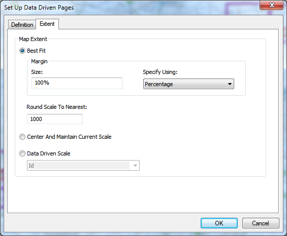
6 Step 4 In the menu that pops up, set the Layer to your Index and Name field to Unique. In Extent, alter this to best suit the mapping but best practice is to round the scale to an even number 4
7 5
 This will output a map for each index box. They can be saved as individual PDF files or a merged map book.")
8 Step 5 Once you have your layout as desired and the required datasets added, select the Export map option and under Pages select to output all pages (or a selection if required) This will output a map for each index box. They can be saved as individual PDF files or a merged map book. 6

9 Step 6 Once one map type is complete, the template can be saved and then a new data type added and another set of maps output. In this way multiple map types can be quickly and efficiently produced. Step 7 Here are various options and methods for adding text to your layout which will automatically update for each grid in the index. This is done using the Insert Dynamic Text Option from the tools menu. Boxes can be created to automate Date, time, for the Unique Grid ID to show up in the side bar to differentiate the maps. Additional fields can be added to the grid and any text added to these can be automated allowing the batch production of unique and refined maps for a project. 7
10 2. GIS Tricks for QQIS Users 2.1 What is QGIS? QGIS is a free user friendly Open-Source Geographic Information system. QGIS is licensed under the GNU General Public License. It is an official project of the Open Source Geospatial Foundation (OSGeo). It runs on Linux, Unix, Mac OSX, Windows and Android and supports numerous vector, raster, and database formats and functionalities Developed by volunteers and stream- lined by users over the last number of years. Now up to version Free Tools equivalent to ArcGIS Extensions (which cost approx each) Examples - Spatial Analyst tools such as Raster Calculator and Data interpolation 2.2 Where can I download QGIS? Free download from Share data to Google Earth Add data using the following tab (Varies based on QGIS version) Once added select the data and click save as. 8
 Once the data is saved it can be easily")

11 In Format, scroll to the KML option as shown and save to a desired location (This menu also allows quick translation of GIS data into multiple other formats including CAD and Microstation in a quick process) Once the data is saved it can be easily ed to anyone and by clicking the file it will automatically open it in Google earth and zoom to the location. For Multiple files, click them one by one to open in the same Google Earth Window. No technical abilities required to add the data. 9

12 3. Easy GIS Non-Technical Tricks 3.1 Layered pdfs Step 1 Maps saved in PDF format from ARCGIS can have Layer functionality. Layers can be turned on and off giving ability to share and view datasets easily. When the GIS user is exporting the map from ARCGIS, under Advanced setting they can change the output to Export PDF Export layers and Feature Attributes (see screen grab) 10
13 Step 2 The PDF can be opened using standard Adobe viewer (already on most computers or free to download) To use layers click on the tab highlighted below This will open the following menu. Click on the + icon beside Layers to expand Group and show all available layers. 11

14 All the layers in the list can be turned on and off using the eye symbols to make spatial comparisons. Clicking on a feature in the map will also show the table data from the original GIS file. In this way one simple PDF file can easily share a large amount of GIS information. 12
15 3.2 Free Online Data share using ArcGIS This allows both licenced and non-licenced users to create and share online, high quality maps. Outputs look similar to those generated in Arc, and many functions of the Arc package can be completed with ease (e.g. editing data, viewing metadata, and some analysis of data) Step 1 Register an account at Arc GIS Licence holders sign in using your ESRI account info Non-licenced users select 60 day trial or Public Account subject to copyright considerations 13

16 Step 2 Activate your account Input Your Organization Info 14
17 Step 3 Click Map on top ribbon to start 15
 NB")

18 Step 4 Add zipped data from file (E.g. NPWS Native woodland obtained from the NPWS Research Branch) NB Data must have less than 1000 features Once imported, select show location only from choose an attribute to show dropdown Select a style and click done. 16
19 Attribute data can be viewed by clicking the Table icon in your Contents Window Step 5 Save Map this will save map to an online folder with your username 17

20 Step 6 Click Share Map and choose either Public (anyone can access map following the web link), or your organisation (only those who can login using your details can access map). Chose to embed the link in the website, or create a web app. The Web App means your page is similarly accessed by a link, but is not within the ArcGIS online portal. The Webapp takes more work to setup, but has lots of increased functionality, including the ability to insert logos (insert using a URL obtained from a google image search).step 7 To allow users to edit the map, you must re-add each shapefile for which you want editability functionality. It is first useful to open a separate browser (and login to Arc) to access your Content store To do this, go to the Content Tab Now add the zipped shapefile you would like make editable Click the shapefile within the content tab, to enter the page for the shapefile itself. Then click share. 18
21 The final step to make the shapefile editable, is to select Editing options under Properties 19
Guide to Viewing Maps in Google Earth
 Guide to Viewing Maps in Google Earth The BCT made the decision to provide the GIS (Geographic Information System) resources for Bat Groups in the form of Google Earth maps because they do not require
A Brief Explanation of Basic Web Services
 A Brief Explanation of Basic Web Services What is REST? REpresentational State Transfer (REST) is a way for software to work when distributed across a network. For example, if I want to view the Iowa Dept
Institute of Natural Resources Departament of General Geology and Land use planning Work with a MAPS
 Institute of Natural Resources Departament of General Geology and Land use planning Work with a MAPS Lecturers: Berchuk V.Y. Gutareva N.Y. Contents: 1. Qgis; 2. General information; 3. Qgis desktop; 4.
HELCOM Data and Map Service. User Manual
 HELCOM Data and Map Service User Manual Version 2.2 - February 2015 1 Table of contents 1. General Information... 3 1.1 Background... 3 1.2 Technical requirements... 3 1.3 Contact... 3 2. Accessing HELCOM
INTRODUCTION to ESRI ARCGIS For Visualization, CPSC 178
 INTRODUCTION to ESRI ARCGIS For Visualization, CPSC 178 1) Navigate to the C:/temp folder 2) Make a directory using your initials. 3) Use your web browser to navigate to www.library.yale.edu/mapcoll/ and
Publishing geospatial data to the web using the EEA infrastructure
 Publishing geospatial data to the web using the EEA infrastructure *Note: Map Services should be published using the EEA Map Services Tick Sheet for guidance. Contact Sebastien Petit (Sebastien.Petit@eea.europa.eu)
There are various ways to find data using the Hennepin County GIS Open Data site:
 Finding Data There are various ways to find data using the Hennepin County GIS Open Data site: Type in a subject or keyword in the search bar at the top of the page and press the Enter key or click the
Quick Start Guide to. ArcGISSM. Online
 Quick Start Guide to ArcGISSM Online ArcGIS Online Quick Start Guide ArcGIS SM Online is a cloud-based mapping platform for organizations. Users get access to dynamic, authoritative content to create,
BLM Personnel & REA Collaborator Access. Accessing REA Data, Maps, & Models through SharePoint
 Accessing REA Data, Maps, & Models through SharePoint BLM Personnel & REA Collaborator Access To access REA data and map services through the BLM network, follow the steps provided below. They will take
A Workflow for Creating and Sharing Maps
 A Workflow for Creating and Sharing Maps By Keith Mann, Esri What You Will Need Item Source ArcGIS Online for Organizations subscription ArcGIS 10.1 for Desktop (Any license level) ArcGIS Spatial Analyst
Quick and Easy Web Maps with Google Fusion Tables. SCO Technical Paper
 Quick and Easy Web Maps with Google Fusion Tables SCO Technical Paper Version History Version Date Notes Author/Contact 1.0 July, 2011 Initial document created. Howard Veregin 1.1 Dec., 2011 Updated to
ArcGIS online Introduction... 2. Module 1: How to create a basic map on ArcGIS online... 3. Creating a public account with ArcGIS online...
 Table of Contents ArcGIS online Introduction... 2 Module 1: How to create a basic map on ArcGIS online... 3 Creating a public account with ArcGIS online... 3 Opening a Map, Adding a Basemap and then Saving
Data Interoperability Extension Tutorial
 Data Interoperability Extension Tutorial Copyright 1995-2010 Esri All rights reserved. Table of Contents About the Data Interoperability extension tutorial...................... 3 Exercise 1: Using direct-read
Geocortex HTML 5 Viewer Manual
 1 FAQ Nothing Happens When I Print? How Do I Search? How Do I Find Feature Information? How Do I Print? How can I Email A Map? How Do I See the Legend? How Do I Find the Coordinates of a Location? How
Introduction to GIS software
 Introduction to GIS software There are a wide variety of GIS software packages available. Some of these software packages are freely available for you to download and could be used in your classroom. ArcGIS
Quick Start Guide to. ArcGISSM. Online. for Public Accounts
 Quick Start Guide to ArcGISSM Online for Public Accounts Using ArcGIS Online with a Public Account ArcGIS SM Online is a cloud-based mapping platform that allows you to easily and quickly make maps, collaborate,
Creating Figure Ground Maps in ArcMap 10.x: Basic procedures to download, open, manipulate and print spatial data
 Creating Figure Ground Maps in ArcMap 10.x: Basic procedures to download, open, manipulate and print spatial data These procedures outline: A. Retrieving Property Data B. Uncompressing the Downloaded Files
WatchDox for Mac User Guide
 WatchDox for Mac User Guide Version 2.3.0 Confidentiality This document contains confidential material that is proprietary to WatchDox. The information and ideas herein may not be disclosed to any unauthorized
Managing your Joomla! 3 Content Management System (CMS) Website Websites For Small Business
 Website Websites For Small Business") 2015 Managing your Joomla! 3 Content Management System (CMS) Website Websites For Small Business This manual will take you through all the areas that you are likely to use in order to maintain, update
2015 Managing your Joomla! 3 Content Management System (CMS) Website Websites For Small Business This manual will take you through all the areas that you are likely to use in order to maintain, update
INSTRUCTIONS FOR MAKING 3D,.DWG CONTOUR LINES
 INSTRUCTIONS FOR MAKING 3D,.DWG CONTOUR LINES A TUTORIAL FROM SPATIAL AND NUMERIC DATA SERVICES NICOLE SCHOLTZ AND GEOFF IVERSON Overview... 2 A. Get a Digital Elevation Model (DEM)... 3 B. Open ArcMap,
How to Remotely Access the C&CDHB Network from a Personal Device
 How to Remotely Access the C&CDHB Network from a Personal Device 13/09/2012 Contents Installing the Citrix Receiver for Windows PCs... 2 Installing the Citrix Receiver for Mac OS X... 6 Installing the
OneDrive for Business User Guide
 OneDrive for Business User Guide Contents About OneDrive for Business and Office 365... 2 Storing University Information in the Cloud... 2 Signing in... 2 The Office 365 Interface... 3 The OneDrive for
DWGSee Professional User Guide
 DWGSee Professional User Guide DWGSee is comprehensive software for viewing, printing, marking and sharing DWG files. It is fast, powerful and easy-to-use for every expert and beginners. Starting DWGSee
Quick Reference Guide PAYMENT GATEWAY (Virtual Terminal)
") PAYMENT GATEWAY (Virtual Terminal) Document Version 131227 Copyright 2013 epaymentamerica, Inc. All Rights Reserved Logging in to the Virtual Terminal 1. Open your internet browser; We strongly recommend
PAYMENT GATEWAY (Virtual Terminal) Document Version 131227 Copyright 2013 epaymentamerica, Inc. All Rights Reserved Logging in to the Virtual Terminal 1. Open your internet browser; We strongly recommend
Finding GIS Data and Preparing it for Use
 Finding_Data_Tutorial.Doc Page 1 of 19 Getting Ready for the Tutorial Sign Up for the GIS-L Listserv Finding GIS Data and Preparing it for Use The Yale University GIS-L Listserv is an internal University
GIS I Business Exr02 (av 9-10) - Expand Market Share (v3b, Jul 2013)
 - Expand Market Share (v3b, Jul 2013)") GIS I Business Exr02 (av 9-10) - Expand Market Share (v3b, Jul 2013) Learning Objectives: Reinforce information literacy skills Reinforce database manipulation / querying skills Reinforce joining and mapping
GIS I Business Exr02 (av 9-10) - Expand Market Share (v3b, Jul 2013) Learning Objectives: Reinforce information literacy skills Reinforce database manipulation / querying skills Reinforce joining and mapping
AutoDWG DWGSee DWG Viewer. DWGSee User Guide
 DWGSee User Guide DWGSee is comprehensive software for viewing, printing, marking and sharing DWG files. It is fast, powerful and easy-to-use for every expert and beginners. Starting DWGSee After you install
Data source, type, and file naming convention
 Exercise 1: Basic visualization of LiDAR Digital Elevation Models using ArcGIS Introduction This exercise covers activities associated with basic visualization of LiDAR Digital Elevation Models using ArcGIS.
An Introduction to Box.com
 An Introduction to Box.com Box is an online file sharing and cloud content management service and it provides features such as: Security controls Space Mobility Online collaboration Mobile access Version
Access the TCNJ Palo Alto Networks VPN using the GlobalProtect VPN client
 Access the TCNJ Palo Alto Networks VPN using the GlobalProtect VPN client June 2014 Table of Contents Introduction 1 Determine the Windows Operating System Version 2 Install the GlobalProtect VPN client
64 Bits of MapInfo Pro!!! and the next BIG thing. March 2015
 64 Bits of MapInfo Pro!!! and the next BIG thing March 2015 MapInfo Professional v12.5 Themes Cartographic output Performance improvements Ability to work directly with a map in a layout. An all new Layout
imageprograf Direct Print & Share Guide
 imageprograf Direct Print & Share Guide imageprograf Direct Print & Share Guide Ver. 2.0 Canon Inc. 1. Features of imageprograf Direct Print & Share The features of imageprograf Direct Print & Share are
Labour Market Programs Support System. LaMPSS Computer Compatibility Guide
 Labour Market Programs Support System LaMPSS Computer Compatibility Guide Prepared by: LaMPSS Operations Support June 2012 Version: 1.1 2011 Nova Scotia Department of Labour and Advanced Education This
Insight for location-powered decision making.
 Location Intelligence Geographic Information Systems MapInfo Pro Insight for location-powered decision making. Data drives our decisions every day. Blend this data with geography and you can visualise
Creating Web and Mobile Maps Using ArcGIS Online. SCO Technical Paper
 Creating Web and Mobile Maps Using ArcGIS Online SCO Technical Paper Version History Version Date Notes Author/Contact 1.0 February, 2012 Initial document created. John J Czaplewski Copyright 2012 The
How to create PDF maps, pdf layer maps and pdf maps with attributes using ArcGIS. Lynne W Fielding, GISP Town of Westwood
 How to create PDF maps, pdf layer maps and pdf maps with attributes using ArcGIS Lynne W Fielding, GISP Town of Westwood PDF maps are a very handy way to share your information with the public as well
Document OwnCloud Collaboration Server (DOCS) User Manual. How to Access Document Storage
 User Manual. How to Access Document Storage") Document OwnCloud Collaboration Server (DOCS) User Manual How to Access Document Storage You can connect to your Document OwnCloud Collaboration Server (DOCS) using any web browser. Server can be accessed
Document OwnCloud Collaboration Server (DOCS) User Manual How to Access Document Storage You can connect to your Document OwnCloud Collaboration Server (DOCS) using any web browser. Server can be accessed
1. Right click using your mouse on the desktop and select New Shortcut.
 offers 3 login page styles: Standard Login, List Login or Quick Time Punch. Each login page can be saved as a shortcut to your desktop or as a bookmark for easy fast login access. For quicker access to
Uploading and Editing Your Course Web Page
 Uploading and Editing Your Course Web Page CM210 Multimedia Storytelling I Fall 2008 Downloading the Web Page Template I have created and styled a simple Web page that everyone can use as the index page
Publishing KML Services Tutorial
 Publishing KML Services Tutorial Copyright 1995-2010 Esri All rights reserved. Table of Contents Tutorial: Publishing a KML service............................ 3 Copyright 1995-2010 ESRI, Inc. All rights
Creating Maps in QGIS: A Quick Guide
 Creating Maps in QGIS: A Quick Guide Overview Quantum GIS, which is often called QGIS, is an open source GIS desktop application. Comparing to ArcGIS, QGIS can be installed on various operating systems,
Remote Viewer Recording Backup
 Remote Viewer Recording Backup Introduction: In this tutorial we will explain how to retrieve your recordings using the Web Service online. Using this method you can backup videos onto your computer using
Community Health Maps Lab Series:
 Community Health Maps Lab Series: Lab 6 Data Visualization With CartoDB Objective: Understand How To Use CartoDB To Create an Online Visualization of Your Data Document Version: 2015-09-15 (V2) This course
How to Add Users 1. 2.
 Administrator Guide Contents How to Add Users... 2 How to Delete a User... 9 How to Create Sub-groups... 12 How to Edit the Email Sent Out to New Users... 14 How to Edit and Add a Logo to Your Group's
Adobe Marketing Cloud Bloodhound for Mac 3.0
 Adobe Marketing Cloud Bloodhound for Mac 3.0 Contents Adobe Bloodhound for Mac 3.x for OSX...3 Getting Started...4 Processing Rules Mapping...6 Enable SSL...7 View Hits...8 Save Hits into a Test...9 Compare
Introduction to GIS. http://libguides.mit.edu/gis
 Introduction to GIS http://libguides.mit.edu/gis 1 Overview What is GIS? Types of Data and Projections What can I do with GIS? Data Sources and Formats Software Data Management Tips 2 What is GIS? 3 Characteristics
Site Administrator User Guide. show, tell, share
 Site Administrator User Guide show, tell, share Contents About your Team site 1 What is a Team site? 1 What can you do on a Team or Business site that you can t do on www.present.me? 1 Getting Started
Guide to Managing Your Online Account
 Guide to Managing Your Online Account Contents 1 Introduction 3 1.1 Downloading your security certificate 3 1.2 Accessing your Online Account 3 1.3 What is a Security Certificate? 5 1.4 Saving your Security
Creating a Website with Google Sites
 Creating a Website with Google Sites This document provides instructions for creating and publishing a website with Google Sites. At no charge, Google Sites allows you to create a website for various uses,
What do I do first in ArcView 8.x? When the program starts Select from the Dialog box: A new empty map
 www.library.carleton.ca/find/gis Introduction Introduction to Georeferenced Images using ArcGIS Georeferenced images such as aerial photographs or satellite images can be used in many ways in both GIS
Microsoft PowerPoint 2011
 Microsoft PowerPoint 2011 Starting PowerPoint... 2 Creating Slides in Your Presentation... 3 Beginning with the Title Slide... 3 Inserting a New Slide... 3 Adding an Image to a Slide... 4 Downloading Images
How to Build a SharePoint Website
 How to Build a SharePoint Website Beginners Guide to SharePoint Overview: 1. Introduction 2. Access your SharePoint Site 3. Edit Your Home Page 4. Working With Text 5. Inserting Pictures 6. Making Tables
Remote Access End User Reference Guide for SHC Portal Access
 Remote Access End User Reference Guide for SHC Portal Access Version 2.0 6/7/2012 This remote access end user reference guide provides an overview of how to install Citrix receiver, which is a required
Online Data Delivery System
 Version: February 2014 Version 3.0 Disclaimer PSMA Australia believes this publication to be correct at the time of printing and does not accept responsibility for any consequences arising from the use
Initial Setup of Microsoft Outlook 2011 with IMAP for OS X Lion
 Initial Setup of Microsoft Outlook Concept This document describes the procedures for setting up the Microsoft Outlook email client to download messages from Google Mail using Internet Message Access Protocol
Installing TestNav Mac with Apple Remote Desktop
 Installing TestNav Mac with Apple Remote Desktop 1 2 3 Getting TestNav Installation from Servicedesk 1.1 Connect to Servicedesk 4 1.2 Download Package to Desktop 7 Installing TestNav 2.1 Add Computers
smespire - Exercises for the Hands-on Training on INSPIRE Network Services April 2014 Jacxsens Paul SADL KU Leuven
 smespire - Exercises for the Hands-on Training on INSPIRE Network Services April 2014 Jacxsens Paul SADL KU Leuven These exercises aim at people who already have some basic knowledge of INSPIRE Network
How to borrow and download an ebook using Bolinda (PC)
") How to borrow and download an ebook using Bolinda (PC) Before you begin, you will need: Your library card number and PIN An email address Note: If you have already installed Adobe Digital Editions on your
How to borrow and download an ebook using Bolinda (PC) Before you begin, you will need: Your library card number and PIN An email address Note: If you have already installed Adobe Digital Editions on your
Creating a Website with Google Sites
 Creating a Website with Google Sites This document provides instructions for creating and publishing a website with Google Sites. At no charge, Google Sites allows you to create a website for various uses,
Chapter 6: Data Acquisition Methods, Procedures, and Issues
 Chapter 6: Data Acquisition Methods, Procedures, and Issues In this Exercise: Data Acquisition Downloading Geographic Data Accessing Data Via Web Map Service Using Data from a Text File or Spreadsheet
Getting Started with ArcGIS Online Organization Accounts (Virginia K-12)
") Getting Started with ArcGIS Online Organization Accounts (Virginia K-12) In this activity, you will: Learn how to establish an ArcGIS online organization account for K-12 education. Learn how to create
Getting Started with ArcGIS Online Organization Accounts (Virginia K-12) In this activity, you will: Learn how to establish an ArcGIS online organization account for K-12 education. Learn how to create
Create a folder on your network drive called DEM. This is where data for the first part of this lesson will be stored.
 In this lesson you will create a Digital Elevation Model (DEM). A DEM is a gridded array of elevations. In its raw form it is an ASCII, or text, file. First, you will interpolate elevations on a topographic
QUICK START FOR COURSES: USING BASIC COURSE SITE FEATURES
 collab.virginia.edu UVACOLLAB QUICK START FOR COURSES: USING BASIC COURSE SITE FEATURES UVaCollab Quick Start Series collab-support@virginia.edu Revised 5/20/2015 Quick Start for Courses Overview... 4
Contents. The OWRB Floodplain Viewer. Creating Maps... 8. Helpful Tips... 10
 Contents QUICK START GUIDE... 2-5 Add layers...9 Search for Layers...9 COMPREHENSIVE GUIDE... 6 Navigate the map...6 Locate specific places...6 Add layer from file...9 Add layer from web...9 Display pop-up
Connection. to SECON-Server
 Technical Documentation SECON-X OpenVPN Installation Connection. to SECON-Server Version: 1 Edition: 2015-03 Art. No: 350199 FAFNIR GmbH Bahrenfelder Str. 19 22765 Hamburg, Germany Tel.: +49 / 40 / 39
Implementing a Web-based Transportation Data Management System
 Presentation for the ITE District 6 Annual Meeting, June 2006, Honolulu 1 Implementing a Web-based Transportation Data Management System Tim Welch 1, Kristin Tufte 2, Ransford S. McCourt 3, Robert L. Bertini
Install and End User Reference Guide for Direct Access to Citrix Applications
 Install and End User Reference Guide for Direct Access to Citrix Applications Version 1.0 7/26/2013 This remote access end user reference guide provides an overview of how to install Citrix receiver (a
Initial Setup of Microsoft Outlook with Google Apps Sync for Windows 7. Initial Setup of Microsoft Outlook with Google Apps Sync for Windows 7
 Microsoft Outlook with Initial Setup of Concept This document describes the procedures for setting up the Microsoft Outlook email client to download messages from Google Mail using Internet Message Access
Citrix Client Install Instructions
 Citrix Client Install Instructions If you are using Citrix remotely, Information Technology Services recommends updating Citrix client to the newest version available online. You must be an administrator
NHS Professionals Online Management Information System Training Manual Management Information Training Manual
 NHS Professionals Online Management Information System Training Manual Author and Creation date: Mark Frost October 2010 Page 1 Contents Page 1. Getting Started...3 2. Overview...4 3. The System Toolbar...5
Integrated Accounting System for Mac OS X
 Integrated Accounting System for Mac OS X Program version: 6.3 110401 2011 HansaWorld Ireland Limited, Dublin, Ireland Preface Standard Accounts is a powerful accounting system for Mac OS X. Text in square
USER MANUAL (PRO-CURO LITE, PRO & ENT) [SUPPLIED FOR VERSION 3]
![USER MANUAL (PRO-CURO LITE, PRO & ENT) [SUPPLIED FOR VERSION 3]](/thumbs/39/19325006.jpg "USER MANUAL (PRO-CURO LITE, PRO & ENT) [SUPPLIED FOR VERSION 3]") Pro-curo Software Ltd USER MANUAL (PRO-CURO LITE, PRO & ENT) [SUPPLIED FOR VERSION 3] CONTENTS Everyday use... 3 Logging on... 4 Main Screen... 5 Adding locations... 6 Working with locations... 7 Duplicate...
Pro-curo Software Ltd USER MANUAL (PRO-CURO LITE, PRO & ENT) [SUPPLIED FOR VERSION 3] CONTENTS Everyday use... 3 Logging on... 4 Main Screen... 5 Adding locations... 6 Working with locations... 7 Duplicate...
FME Server Tutorial. FME 2014 Edition
 FME Server Tutorial FME 2014 Edition Document and Copyright Information Safe Software Inc. makes no warranty either expressed or implied, including, but not limited to, any implied warranties of merchantability
SimplyMap Canada Tutorial
 SimplyMap Canada Tutorial SimplyMap Canada is a web mapping application developed by Geographic Research Inc. The application enables users to create thematic maps and reports using demographic, business,
Microsoft PowerPoint 2010
 Microsoft PowerPoint 2010 Starting PowerPoint... 2 PowerPoint Window Properties... 2 The Ribbon... 3 Default Tabs... 3 Contextual Tabs... 3 Minimizing and Restoring the Ribbon... 4 The Backstage View...
WFP Liberia Country Office
 1 Oscar Gobbato oscar.gobbato@wfp.org oscar.gobbato@libero.it WFP Liberia Country Office GIS training - Summary Objectives 1 To introduce to participants the basic concepts and techniques in using Geographic
Enterprise GIS Solutions to GIS Data Dissemination
 Enterprise GIS Solutions to GIS Data Dissemination ESRI International User Conference July 13 17, 2009 Wendy M. Turner Senior GIS Engineer & Program Manager Freedom Consulting Group, LLC Building the Enterprise
Build an ArcGIS Online Application
 Build an ArcGIS Online Application Sign into ArcGIS Online for Maryland 1. Open a web browser 2. Go to URL http://maryland.maps.arcgis.com/ 3. Click Sign In in the upper right corner of the web page 4.
emarketing Manual- Creating a New Email
 emarketing Manual- Creating a New Email Create a new email: You can create a new email by clicking the button labeled Create New Email located at the top of the main page. Once you click this button, a
LiveStreamingCDN Producer User s Guide
 LiveStreamingCDN Producer User s Guide A LiveStreamingCDN Producer account offers a variety of premium features in addition to live and VOD streaming capabilities. A Producer account comes with a multi-device
How to install and use the File Sharing Outlook Plugin
 How to install and use the File Sharing Outlook Plugin Thank you for purchasing Green House Data File Sharing. This guide will show you how to install and configure the Outlook Plugin on your desktop.
An Esri White Paper October 2010 Esri Production Mapping Product Library: Spatially Enabled Document Management System
 An Esri White Paper October 2010 Esri Production Mapping Product Library: Spatially Enabled Document Management System Esri, 380 New York St., Redlands, CA 92373-8100 USA TEL 909-793-2853 FAX 909-793-5953
How To Connect Your Cloud
 How To Connect Your Cloud This tutorial will show you how to connect ncrypted Cloud to multiple cloud storage accounts after installation. This will allow you to apply privacy to all cloud data right from
Creating a Participants Mailing and/or Contact List:
 Creating a Participants Mailing and/or Contact List: The Limited Query function allows a staff member to retrieve (query) certain information from the Mediated Services system. This information is from
How to configure your Acrobat Signature Appearance
 How to configure your Acrobat Signature Appearance An Acrobat Signature Appearance for use within SpeediSign is created within Adobe Acrobat Professional. This signature appearance is then called within
Software: AutoCAD Civil 3D 2014, NRCS C3D 2014 template, ESRI ArcMap. Notation:Button to Press Displayed Text Icon Action {Text to Enter} Menu Item
 Overview: Use the following processes for exchanging georeferenced data between AutoCAD Civil 3D 2014 and ArcMap. The work must be based in any real world coordinate system. (This example uses NAD 83 UTM
Educational Level Guide. Pros
 GIS software summary This information is based on an evaluation carried out on behalf of the RGS-IBG (please see disclaimer). Category* Cost E- learnin g credits Educational Level Guide Pros Cons Summary
PMI Marketing Portal User Guide
 PMI Marketing Portal User Guide PMI Marketing Portal: Supporting member and credential holder acquisition and retention 2010 Project Management Institute, Inc. All right reserved. PMI, the PMI logo and
Step by Step Guide for GIS Cloud Applications
 Step by Step Guide for GIS Cloud Applications All in one manual for: Map Editor Map Viewer Asset Data Collection and Management Fleet Management Roadwork Management and Coordination Mobile Data Collection
Increasing Productivity and Collaboration with Google Docs. Charina Ong Educational Technologist charina.ong@nus.edu.sg
 Increasing Productivity and Collaboration with Google Docs charina.ong@nus.edu.sg Table of Contents About the Workshop... i Workshop Objectives... i Session Prerequisites... i Google Apps... 1 Creating
Extracting Aerial Images From GIS Based Ortho Photos Using ArcMap 9
 Extracting Aerial Images From GIS Based Ortho Photos Using ArcMap 9 Tutorial Updated August 2006 CP-208 Plan Preparation Studio - Prof. Elizabeth Macdonald 2 In this tutorial we will learn to extract aerial
Zoom Cloud Meetings: Leader Guide
 Zoom Cloud Meetings: Leader Guide Zoom is a cloud-based conferencing solution that provides both video conferencing and screen share capabilities. Zoom can be used for meetings among individuals or to
GEM global earthquake model. User guide: Android mobile tool for field data collection. Rosser, J., J.G. Morley, A. Vicini. Data capture tools
 User guide: Android mobile tool for field data collection GEM Technical Report 2014-03 V1.0.0 Rosser, J., J.G. Morley, A. Vicini Data capture tools GEM global earthquake model i User guide: Android mobile
Open Source Desktop GIS Solutions for the Not-So Casual User
 Open Source Desktop GIS Solutions for the Not-So Casual User Roger C. Lowe III Warnell School of Forestry and Natural Resources The University of Georgia Athens, GA 30605 rlo@warnell.uga.edu Abstract Ask
Providing the Public with Data Visualization using Google Maps
 GIS - T March 30 th, 2011 Providing the Public with Data Visualization using Google Maps Patrick Kielty and Matt Allen Pennsylvania Department of Transportation Purpose Quickly and Easily create web based
Intro to evis: the event visualization tool
 Intro to evis: the event visualization tool Background The of the (CBC) at the (AMNH) developed the Event Visualization Tool (evis), as a conservation monitoring and decision support tool for guiding protected
WHAT DOES PROFIBANKA OFFER YOU?
 Profibanka Dear Client, please allow us to welcome you as a user of the Profibanka service a modern direct banking system offered by Komerční banka. Profibanka combines the convenience and performance
GIS Tools for Land Managers
 Citation: Karl, J. 2010. GIS Tools for Land Managers. Sound Science White Paper Series #05. www.sound-science.org. GIS Tools for Land Managers Most land managers recognize that geographic information systems
Sage CRM 6.2 SP1 What's New Guide
 Sage CRM 6.2 SP1 What's New Guide Copyright 2009 Sage Technologies Limited, publisher of this work. All rights reserved. No part of this documentation may be copied, photocopied, reproduced, translated,
Remote Field Service - Androids. Installation Guide
 Remote Field Service - Androids Installation Guide Davisware 514 Market Loop West Dundee, IL 60118 Phone: (847) 426-6000 Fax: (847) 426-6027 Contents are the exclusive property of Davisware. Copyright