Chapter 6: Data Acquisition Methods, Procedures, and Issues
|
|
|
- Ashlie Nelson
- 10 years ago
- Views:
Transcription
1 Chapter 6: Data Acquisition Methods, Procedures, and Issues In this Exercise: Data Acquisition Downloading Geographic Data Accessing Data Via Web Map Service Using Data from a Text File or Spreadsheet w/coordinates Joining Tabular Data Downloading Data from a GPS Creating and Editing Data Online Data Resources Data Acquisition This exercise requires an active Internet connection! The data used in previous exercises has been provided on a CD or loaded directly on the computer. In many situations users will want to build projects that include data acquired from other sources. In addition, users will frequently add data that they themselves have created to overlay with available geographic data. The process of Data Acquisition involves a number of specific tasks that can be challenging. Procedures typically include: Locating and reviewing the properties of available geographic data Downloading files Extracting contents from compressed files (used to reduce file size) Transferring all relevant files to directories for use in the GIS application There are a number of issues to consider when beginning the Data Acquisition process that can be identified by viewing available Metadata. Data Acquisition and Metadata Metadata should always accompany geographic data. As mentioned in previous chapters, metadata is the information that will tell potential users about the specific properties of geographic data layers. All VCGI metadata follows a federal format, however any metadata is better than none! Even a brief paragraph about who created it, why, and when as well as definitions of codes can be invaluable. Ask for information about the data when you get it from a source other than VCGI, and create simple metadata if you create new GIS data. Chapter 6 Page 61

2 1. GIS File Formats Geographic data may be available in a variety of file formats. Thus far we have used ESRI Shapefiles and Imagery in JPEG2000 or TIFF format. QGIS can use data and data services of the following types: PostGIS and SpatiaLite Most vector formats supported by the OGR library, including ESRI shapefiles, MapInfo, SDTS and GML Raster formats supported by the GDAL library, such as digital elevation models, aerial photography or landsat imagery GRASS locations and mapsets Online spatial data served as OGC-compliant WMS, WMS-C (Tile cache), WFS and WFS-T A growing collection of open source software and utilities for GIS that may be useful for file conversions can be found on the Open Source Geospatial Foundation Website ( Metadata, as well as any online description, should include Distribution Information describing the format of the available digital data. 2. Coordinate System and Projection Information In Chapter 4, we set the Coordinate Reference System to VT State Plane Meters, NAD 83. We also turned on the "Enable on the fly CRS Chapter 6 Page 62


3 transformation" option because this will allow the software to transform data from whatever coordinate system and project it is natively in to the coordinate system and projection that we have set for our project. That way all of the data lines up and scales properly. The Spatial Reference Information section of metadata will list information describing the coordinate system. For example, the Vermont State Plane Coordinate System is a Coordinate System that has been projected. This means that the geographic data has been translated from a spheroid surface (the earth) onto a flat map. Metadata will include the projection (Transverse Mercator), the datum (NAD83), map units (Meters), as well as other specific values. Understanding the specific values defined by a Coordinate System and Projection is critical when adding and assembling data themes in a GIS project and application (see below). Downloading Geographic Data Geographic data is available online from a wide variety of sources and websites. 1. Vermont The main source of public GIS data in Vermont is the Data and Imagery section of the VCGI website ( This online resource is available to users who wish to search for and download free Vermont GIS data from VCGI. Many of the data sets created by regional, state, and federal organizations are found here. Available data varies in content, scale, age, and accuracy. It is important to refer to the associated metadata for each data layer. Chapter 6 Page 63
 onto a flat map.")
4 Data is organized by Themes (categories) that may be searched on the warehouse site using the Theme search engine or the Theme Index page to view availability. The Keyword search provides another method for finding specific data layers. To understand the steps involved when acquiring data from the VCGI website, follow the instructions below to download a new data layer. a) From the Data and Imagery page ( type dams into the Keyword search b) Click Go c) Search results will display one (1) data layer, WaterOther_DAMS. d) Click More Info to view additional information about this layer. Chapter 6 Page 64
 From the Data and Imagery page (http://vcgi.vermont.")
 In the Save As window change the name of the file to dams.zip and navigate to a directory where you have been instructed to save files and save this file.")
5 e) Click on to view the metadata file. f) Close the metadata window when done. g) In the Search Results window click on Download in order to download the whole statewide data layer. h) In the Save As window change the name of the file to dams.zip and navigate to a directory where you have been instructed to save files and save this file. i) Using a file manager, navigate to where you have saved the file, right click and choose extract all. Make sure to save the unzipped data to an appropriate folder. When extracted there will be four (4) files that together are necessary for the ESRI Shapefile of dams in Vermont (points). Chapter 6 Page 65
 Using a file manager, navigate to where you have saved the file, right click and choose extract all.")
 Click on \"Download Free Data\">>\"Data Download\" c) Click on \"")
 Click on the \"Search\" button Chapter")
6 2. Data from Other Sources: NH Granit a) Go to b) Click on "Download Free Data">>"Data Download" c) Click on " GRANIT Data Discovery Tool (DDT)" d) Next to the words "Search by theme keyword:" type "Town" in the box e) Click on the "Search" button Chapter 6 Page 66
 Click on the \"Search\" button Chapter")
 g) Save the.zip file in an appropriate location and then extract it to access the two shapefiles within: pba.shp (line data) and pbp.shp (polygon data).")
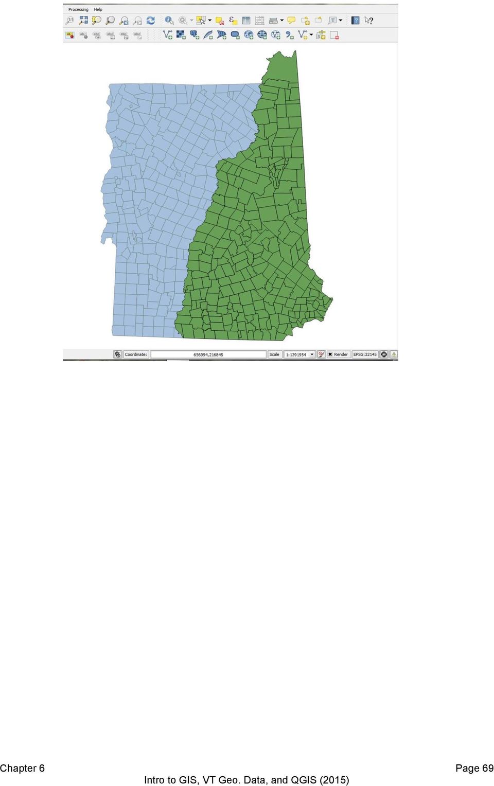
7 f) Download the data called "New Hampshire Political Boundaries at 1:24,000 Scale" by clicking on the "Download Now" button (notice the various settings and options, but leave them set to their defaults) g) Save the.zip file in an appropriate location and then extract it to access the two shapefiles within: pba.shp (line data) and pbp.shp (polygon data). Each of these shapefiles contains political boundaries including town, county, and state. Check the metadata (the.html file) for the codes that allow you to symbolize the data. h) Open QGIS i) Click on the Project menu and then Project Properties Chapter 6 Page 67


8 j) In the CRS tab, turn on enable on the fly CRS transformation k) Type Vermont in the Filter l) Choose NAD83/Vermont and then click OK m) One of the files associated with the shapefiles you downloaded from Granite is the.prj file (projection file) which basically says "this data is in NH State Plane Feet NAD 83 coordinate system" The software is able to do the mathematical transformation necessary to re-project the data into VT State Plane Meters. This is why the VT and NH Town boundaries will line up and scale properly. n) Setting the project to a particular projection and coordinate system also tells the software how to interpret measurements. If it knows the units of the coordinates are meters, it can calculate the distance and area measurements. Chapter 6 Page 68

9 Chapter 6 Page 69

10 3. Accessing Data Via Web Map Service VCGI, in collaboration with VT's Enterprise GIS Consortium (EGC), has developed a portfolio of "web services" which allow users to bring map layers and imagery into their GIS projects or map mashups without actually downloading any data. By connecting to the service of choice via the internet (a live internet connection is required in order for the images to appear in your GIS project) users can access a variety of resources (listed at the Web Services Page at VCGI s web site - a) Go to VCGI s web services page and note that in order to connect via an open source GIS software (like QGIS), you simply right click on the words next to your service of choice that say: ArcGIS 9.3 or Higher and Open Source GIS b) Choose Copy Link Address c) Go back to QGIS and Click on the Add WMS/WMTS Layer button in QGIS Chapter 6 Page 70
.")
 Paste the URL you copied into the appropriate box")
 Click OK g) Click Connect Chapter 6")
11 d) Click on New in the Add Layer(s) from a WM(T)S Server window e) Paste the URL you copied into the appropriate box and type a name into the Name box in the Create a New WMS Connection Window f) Click OK g) Click Connect Chapter 6 Page 71
 Click OK g) Click Connect Chapter 6")
 Click Add then close the Add Layer(s) from a WM(T)S Server window.")
12 h) Click on the service to highlight it i) Type a name in the Layer Name box (or leave the default) j) Make sure that the Image encoding is set to PNG or JPG! k) Click Add then close the Add Layer(s) from a WM(T)S Server window. NOTE: If you add the VCGI Basemap Service, you will be better off adding individual layers from it rather than trying to add the whole thing at once. For some reason, QGIS does not interpret such a complicated service well, and much of the information is lost. 4. Data From a Text File or Spreadsheet Containing Coordinates It is possible to use data from a delimited text file in a QGIS project if that data contains x, y coordinates of a known coordinate reference system (such as latitude longitude). If your data is stored in a spreadsheet, simply do a "save as" to create a.csv version of it (comma separated values). To view a delimited text file as layer, the text file must contain: 1. A delimited header row of field names. This must be the first line in the text file. 2. The header row must contain an X and Y field. These fields can have any name. 3. The x and y coordinates must be specified as a number. The coordinate system is not important, though you do need to know WHAT coordinate system it is. Chapter 6 Page 72


13 We will use a function called "Add delimited text layer." You should see the following icon in your tool bar: When you click on it a dialog box opens that allows you to indicate where your comma or tab delimited text file is located and which fields contain the latitude and longitude coordinates. You can use the file called "NH_DAMS.csv" found in your DATA directory or another file that your instructor may indicate. Navigate to the location of the file, and make sure that all information in the dialog box is correct (is data delimited by tab or comma? Does the first row/record contain field names? Which fields contain the x/longitude info and y/latitude info?). The bottom window in the box will show what the data looks like based on the information you have provided, so you can make sure you have filled in the correct answers. After you click on "OK" Quantum will ask you what Coordinate System the data is in. If you have latitude and longitude coordinates, choose from the "Geographic Coordinate Systems" and find "WGS 1984." Click "OK" and the data should appear on your map in the correct area! Chapter 6 Page 73


14 5. Joining Data from a Text File Via a Common Attribute Another way to create geospatial data is to join tabular data to existing geospatial data. Let s say we have a table indicating the most recent update year for each town s parcel data. We want to join that table to the existing town boundary data so that we can create a map that uses that parcel update year to symbolize each town. Before considering any table joins, the most vital aspect to consider is the JOIN FIELD. The join field must contain matching values (in the same format, such as STRING or INTEGER) in both the source table and the target layer. If you find that existing geographic codes do not work for your data, create your own set of UNIQUE IDs and don't alter them. Persistence of IDENTIFIERS help to keep your data organized and consistent. In our example, we have town names in exactly the same format in our table as in our town boundary layer, so we can join on town name. 1. Open or create a project containing the Town Boundary layer. 2. Click on the Add Vector Layer button and add the.csv file called Parcel_Status 3. Right click on the Town Boundary layer in the layer list and choose Properties 4. Choose the Join section 5. Click on the green Plus sign near the bottom of the dialogue box 6. Choose the correct Join Layer (the CSV file you just brought in) 7. Make sure the Join field and the Target field are correct and match (Townname) 8. Click OK and OK again 9. Open the attribute table to see if the new set of attributes were successfully joined to your Town Boundary layer 10. If they were, you can now symbolize using these attributes 6. Turning On the GPS Tools Plugin a) Install the firmware that came with your GPS b) Click on Plugins in the menus area c) Click on Manage Plugins d) Find the GPS Tools Plugin and make sure the box next to it has an X in it (click on box if not) e) Click on OK Chapter 6 Page 74

 This process results in downloading and using your data in a.gpx format.")
15 Adding Data From A GPS a) Plug your GPS into your computer Click on the GPS Tools icon to download data from your GPS to your computer. i. Make sure that the fields are filled in as below and give your data a name, then browse to where you want to save it, then click OK ii. Follow the same steps to download the tracks you collected (change Feature Type to Tracks) This process results in downloading and using your data in a.gpx format. You can also use QGIS to transform the data into Shapefile or KML format by right clicking on it in the Layers list, then choosing Save As. Creating and Editing Data 1. Editing Data We can edit our data if we need to add or change attributes or add or move features. We can only edit shapefiles, not.gpx or text file or joined data. You can always save your.gpx or text file or joined data out as a new shapefile, however, that you can then edit. In order to edit the attributes of a data layer, we will highlight it, right click and then choose Open Attribute Table a) Click on the Toggle Editing icon to turn on editing Chapter 6 Page 75

 Hold your cursor over the other icons at the top of the attribute table window to see what they do. Notice that you can add a new column and you can delete columns.")
16 b) Once editing is turned on, you can click on any of the values in the attribute table and change them by double clicking and typing. c) Hold your cursor over the other icons at the top of the attribute table window to see what they do. Notice that you can add a new column and you can delete columns. You ARE changing the data when you perform these actions, so be careful! d) Click on the Field Calculator button to see that you can calculate values to populate new or existing fields. e) When you turn editing off, you will be asked whether you want to save changes. 2. Creating New Vector Data a. Click on the New Shapefile Layer button b. Set the type of data you wish to create: Point, Line, or Polygon c. Specify the Coordinate Reference System d. Add attribute fields, choosing their specifications carefully e. Click OK when you are done creating your shapefile f. Save your new shapefile to an appropriate location g. Zoom to a level appropriate to the data you wish to create h. Click on the Toggle Editing button to turn editing on. i. Click on the Add Feature button next to the editing toggle and then start clicking on the map to add features. Chapter 6 Page 76
 When you turn editing off, you will be asked whether you want to save changes. 2. Creating New Vector Data a. Click on the New Shapefile Layer button b.")
17 j. If you are creating point features you will be given the opportunity to fill in the attribute fields each time you click to add a point. k. If you are creating line or polygon features, you will right click to indicate you are done with that particular feature, and then you will be able to edit the attributes. Online Resources: The most important Vermont other data source and technical advice resource: Regional Planning Commissions. Other states have organizations similar to VCGI, and many federal agencies make GIS data available for download or web map service. You will find links to their contact information as well as links to other GIS organizations here: Chapter 6 Page 77

There are various ways to find data using the Hennepin County GIS Open Data site:
 Finding Data There are various ways to find data using the Hennepin County GIS Open Data site: Type in a subject or keyword in the search bar at the top of the page and press the Enter key or click the
Activity: Using ArcGIS Explorer
 Activity: Using ArcGIS Explorer Requirements You must have ArcGIS Explorer for this activity. Preparation: Download ArcGIS Explorer. The link below will bring you to the ESRI ArcGIS Explorer download page.
ArcGIS online Introduction... 2. Module 1: How to create a basic map on ArcGIS online... 3. Creating a public account with ArcGIS online...
 Table of Contents ArcGIS online Introduction... 2 Module 1: How to create a basic map on ArcGIS online... 3 Creating a public account with ArcGIS online... 3 Opening a Map, Adding a Basemap and then Saving
Creating Maps in QGIS: A Quick Guide
 Creating Maps in QGIS: A Quick Guide Overview Quantum GIS, which is often called QGIS, is an open source GIS desktop application. Comparing to ArcGIS, QGIS can be installed on various operating systems,
An Introduction to Geographic Information Systems (GIS) using Quantum GIS (QGIS) version 1.8.0 (Lisboa)
 using Quantum GIS (QGIS) version 1.8.0 (Lisboa)") An Introduction to Geographic Information Systems (GIS) using Quantum GIS (QGIS) version 1.8.0 (Lisboa) by University of Toronto Map and Data Library, June 2012 [email protected] http://mdl.library.utoronto.ca
An Introduction to Geographic Information Systems (GIS) using Quantum GIS (QGIS) version 1.8.0 (Lisboa) by University of Toronto Map and Data Library, June 2012 [email protected] http://mdl.library.utoronto.ca
Creating Figure Ground Maps in ArcMap 10.x: Basic procedures to download, open, manipulate and print spatial data
 Creating Figure Ground Maps in ArcMap 10.x: Basic procedures to download, open, manipulate and print spatial data These procedures outline: A. Retrieving Property Data B. Uncompressing the Downloaded Files
Finding GIS Data and Preparing it for Use
 Finding_Data_Tutorial.Doc Page 1 of 19 Getting Ready for the Tutorial Sign Up for the GIS-L Listserv Finding GIS Data and Preparing it for Use The Yale University GIS-L Listserv is an internal University
How to Import Data into Microsoft Access
 How to Import Data into Microsoft Access This tutorial demonstrates how to import an Excel file into an Access database. You can also follow these same steps to import other data tables into Access, such
Quick Start Guide to. ArcGISSM. Online
 Quick Start Guide to ArcGISSM Online ArcGIS Online Quick Start Guide ArcGIS SM Online is a cloud-based mapping platform for organizations. Users get access to dynamic, authoritative content to create,
Institute of Natural Resources Departament of General Geology and Land use planning Work with a MAPS
 Institute of Natural Resources Departament of General Geology and Land use planning Work with a MAPS Lecturers: Berchuk V.Y. Gutareva N.Y. Contents: 1. Qgis; 2. General information; 3. Qgis desktop; 4.
Software: AutoCAD Civil 3D 2014, NRCS C3D 2014 template, ESRI ArcMap. Notation:Button to Press Displayed Text Icon Action {Text to Enter} Menu Item
 Overview: Use the following processes for exchanging georeferenced data between AutoCAD Civil 3D 2014 and ArcMap. The work must be based in any real world coordinate system. (This example uses NAD 83 UTM
Image Registration. Using Quantum GIS
 Using Quantum GIS Tutorial ID: IGET_GIS_004 This tutorial has been developed by BVIEER as part of the IGET web portal intended to provide easy access to geospatial education. This tutorial is released
Contents. The OWRB Floodplain Viewer. Creating Maps... 8. Helpful Tips... 10
 Contents QUICK START GUIDE... 2-5 Add layers...9 Search for Layers...9 COMPREHENSIVE GUIDE... 6 Navigate the map...6 Locate specific places...6 Add layer from file...9 Add layer from web...9 Display pop-up
Introduction to GIS software
 Introduction to GIS software There are a wide variety of GIS software packages available. Some of these software packages are freely available for you to download and could be used in your classroom. ArcGIS
Under GIS Data select Hydrography This will show all of the state-wide options for hydrography data. For this project, we want the seventh entry in
 Introductory Exercises for GIS Using ArcMap & ArcCatalog GIS Cyberinfrastructure Module EEB 5894, section 10 Please refer to the ESRI online GIS Dictionary for additional details on any of the terms in
TUTORIAL - Locations & Mapping. Using the ESdat Environmental Database System. For use with ESDAT version 5
 TUTORIAL - Locations & Mapping Using the ESdat Environmental Database System For use with ESDAT version 5 (version 5 software updates available from ) Function Tutorial - Locations and Mapping Table of
WFP Liberia Country Office
 1 Oscar Gobbato [email protected] [email protected] WFP Liberia Country Office GIS training - Summary Objectives 1 To introduce to participants the basic concepts and techniques in using Geographic
Spatial Database Support
 Page 1 of 11 Spatial Database Support Global Mapper can import vector data from and export vector data to the following spatial databases: Esri ArcSDE Geodatabase Esri File Geodatabase Esri Personal Geodatabases
Oklahoma s Open Source Spatial Data Clearinghouse: OKMaps
 Oklahoma s Open Source Spatial Data Clearinghouse: OKMaps Presented by: Mike Sharp State Geographic Information Coordinator Oklahoma Office of Geographic Information MAGIC 2014 Symposium April 28-May1,
HANDS-ON WORKSHOP: SPATIAL DATA VISUALIZATION Using selected Open Source tools and Open Data to visualize your own spatial data
 HANDS-ON WORKSHOP: SPATIAL DATA VISUALIZATION Using selected Open Source tools and Open Data to visualize your own spatial data Barend Köbben Version 2.0 September 4, 2014 Contents 1 Open Data: using OpenStreetMap
smespire - Exercises for the Hands-on Training on INSPIRE Network Services April 2014 Jacxsens Paul SADL KU Leuven
 smespire - Exercises for the Hands-on Training on INSPIRE Network Services April 2014 Jacxsens Paul SADL KU Leuven These exercises aim at people who already have some basic knowledge of INSPIRE Network
INSTRUCTIONS FOR MAKING 3D,.DWG CONTOUR LINES
 INSTRUCTIONS FOR MAKING 3D,.DWG CONTOUR LINES A TUTORIAL FROM SPATIAL AND NUMERIC DATA SERVICES NICOLE SCHOLTZ AND GEOFF IVERSON Overview... 2 A. Get a Digital Elevation Model (DEM)... 3 B. Open ArcMap,
How to Download Census Data from American Factfinder and Display it in ArcMap
 How to Download Census Data from American Factfinder and Display it in ArcMap Factfinder provides census and ACS (American Community Survey) data that can be downloaded in a tabular format and joined with
A GIS helps you answer questions and solve problems by looking at your data in a way that is quickly understood and easily shared.
 A Geographic Information System (GIS) integrates hardware, software, and data for capturing, managing, analyzing, and displaying all forms of geographically referenced information. GIS allows us to view,
Guide to Viewing Maps in Google Earth
 Guide to Viewing Maps in Google Earth The BCT made the decision to provide the GIS (Geographic Information System) resources for Bat Groups in the form of Google Earth maps because they do not require
Earthquakes, volcanoes and plate tectonics in ArcGIS Online
 Earthquakes, volcanoes and plate tectonics in ArcGIS Online For non-commercial use only by schools and universities Copyright Esri UK GIS Esri for School UK Ltd Programme 2014 www.esriuk.com/schools Earthquakes,
Getting Started With LP360
 Getting Started With LP360 10/30/2014 1 Contents What is LP360?... 3 System Requirements... 3 Installing LP360... 4 How to Enable the LP360 Extension... 4 How to Display the LP360 Toolbar... 4 How to Import
Creating Web and Mobile Maps Using ArcGIS Online. SCO Technical Paper
 Creating Web and Mobile Maps Using ArcGIS Online SCO Technical Paper Version History Version Date Notes Author/Contact 1.0 February, 2012 Initial document created. John J Czaplewski Copyright 2012 The
Quick and Easy Web Maps with Google Fusion Tables. SCO Technical Paper
 Quick and Easy Web Maps with Google Fusion Tables SCO Technical Paper Version History Version Date Notes Author/Contact 1.0 July, 2011 Initial document created. Howard Veregin 1.1 Dec., 2011 Updated to
MrSID Plug-in for 3D Analyst
 LizardTech MrSID Plug-in for 3D Analyst User Manual Copyrights Copyright 2009 2010 LizardTech. All rights reserved. Information in this document is subject to change without notice. The software described
From GPS Data Collection to GIS Data Display A Walk-Through Example
 From GPS Data Collection to GIS Data Display A Walk-Through Example The Global Positioning System (GPS) is a satellite based navigation system consisting of 24 satellites, a worldwide network of tracking
HANDS-ON WORKSHOP TOOLS FOR SPATIAL DATA VISUALIZATION: Using selected Open Source tools and Open Data to visualize your own spatial data
 HANDS-ON WORKSHOP TOOLS FOR SPATIAL DATA VISUALIZATION: Using selected Open Source tools and Open Data to visualize your own spatial data Barend Köbben Version 1.0 December 12, 2012 Contents 1 Open Data:
ArcGIS. Image Server tutorial
 ArcGIS 9 ArcGIS Image Server tutorial Copyright 2006, 2007, and 2008 Zanja Technologies, Inc. All rights reserved. The information contained in this work is the property of Zanja Technologies, Inc., under
INTRODUCTION to ESRI ARCGIS For Visualization, CPSC 178
 INTRODUCTION to ESRI ARCGIS For Visualization, CPSC 178 1) Navigate to the C:/temp folder 2) Make a directory using your initials. 3) Use your web browser to navigate to www.library.yale.edu/mapcoll/ and
GEM global earthquake model. User guide: Android mobile tool for field data collection. Rosser, J., J.G. Morley, A. Vicini. Data capture tools
 User guide: Android mobile tool for field data collection GEM Technical Report 2014-03 V1.0.0 Rosser, J., J.G. Morley, A. Vicini Data capture tools GEM global earthquake model i User guide: Android mobile
Create and share a map with GIScloud.com
 Create and share a map with GIScloud.com GIS Cloud is a web based Geographic Information System powered by Cloud Computing and with the full power of desktop GIS. It allows users to create and access your
How to georectify an image in ArcMap 10
 How to georectify an image in ArcMap 10 The University Library has a large collection of historical aerial photos for some North Carolina Counties ( http://www.lib.unc.edu/reference/gis/usda/index.html
Texas Wildfire Risk Assessment Portal (TxWRAP) User Manual. Texas A&M Forest Service
 User Manual. Texas A&M Forest Service") Texas Wildfire Risk Assessment Portal (TxWRAP) User Manual Texas A&M Forest Service October 2012 Table of Contents 1 ABOUT TXWRAP... 7 1.1 ACCESSING TXWRAP... 7 1.2 GETTING SUPPORT... 8 Documentation...
Texas Wildfire Risk Assessment Portal (TxWRAP) User Manual Texas A&M Forest Service October 2012 Table of Contents 1 ABOUT TXWRAP... 7 1.1 ACCESSING TXWRAP... 7 1.2 GETTING SUPPORT... 8 Documentation...
National Register of Historic Places: GIS Webinar Cultural Resource GIS Facility National Park Service June 2012
 National Register of Historic Places: GIS Webinar Cultural Resource GIS Facility National Park Service June 2012 In February and March 2012 the National Register of Historic Places held webinars in conjunction
HELCOM Data and Map Service. User Manual
 HELCOM Data and Map Service User Manual Version 2.2 - February 2015 1 Table of contents 1. General Information... 3 1.1 Background... 3 1.2 Technical requirements... 3 1.3 Contact... 3 2. Accessing HELCOM
Use ArcGIS Online to Manage
 Use ArcGIS Online to Manage Your Own Custom Map Gallery By Keith Mann, Esri Start customizing the template by changing the graphics and the web page title. Wouldn t it be great if you could create a dynamic
Version 3.0, April 16, 2012, updated for ArcGIS 10.0 Produced by the Geographic Information Network of Alaska http://www.gina.alaska.
 Using the AlaskaMapped Web Services in ESRI ArcGIS Version 3.0, April 16, 2012, updated for ArcGIS 10.0 Produced by the Geographic Information Network of Alaska http://www.gina.alaska.edu AlaskaMapped
Data Interoperability Extension Tutorial
 Data Interoperability Extension Tutorial Copyright 1995-2010 Esri All rights reserved. Table of Contents About the Data Interoperability extension tutorial...................... 3 Exercise 1: Using direct-read
Lecture 8. Online GIS
 Lecture 8 Online GIS Lecture 8: Outline I. Online GIS 1. Google Earth 2. MSN Live Maps II. Open Source GIS III. ArcGIS Server and the ESRI suite of online software utility options IV. Advanced Data Mining
Web Ambassador Training on the CMS
 Web Ambassador Training on the CMS Learning Objectives Upon completion of this training, participants will be able to: Describe what is a CMS and how to login Upload files and images Organize content Create
Introduction to GIS. http://libguides.mit.edu/gis
 Introduction to GIS http://libguides.mit.edu/gis 1 Overview What is GIS? Types of Data and Projections What can I do with GIS? Data Sources and Formats Software Data Management Tips 2 What is GIS? 3 Characteristics
The manual can be used as a practical tutorial and aims to teach users how to:
 Introduction This manual is aimed at users of the Rainforest Foundation UK's PostGIS database. It should be read by people wishing to upload and edit GPS survey data as well as by those who will administer
Getting Started With Mortgage MarketSmart
 Getting Started With Mortgage MarketSmart We are excited that you are using Mortgage MarketSmart and hope that you will enjoy being one of its first users. This Getting Started guide is a work in progress,
Five Steps to Better Performance
 Effective Web maps have a specific focus and are designed so users can interact with them to accomplish meaningful tasks. Five Steps to Better Performance Sample methodology for creating a great Web map
Publishing KML Services Tutorial
 Publishing KML Services Tutorial Copyright 1995-2010 Esri All rights reserved. Table of Contents Tutorial: Publishing a KML service............................ 3 Copyright 1995-2010 ESRI, Inc. All rights
Microsoft SharePoint 2010 End User Quick Reference Card
 Microsoft SharePoint 2010 End User Quick Reference Card Microsoft SharePoint 2010 brings together the people, documents, information, and ideas of the University into a customizable workspace where everyone
Radius Maps and Notification Mailing Lists
 Radius Maps and Notification Mailing Lists To use the online map service for obtaining notification lists and location maps, start the mapping service in the browser (mapping.archuletacounty.org/map).
Installing Tri-Global Software
 Installing Tri-Global Software To Begin, let us first talk about the different pieces of software available to you and the purpose for each. The individual software pieces are listed below, with a brief
Introduction to GIS (Basics, Data, Analysis) & Case Studies. 13 th May 2004. Content. What is GIS?
 & Case Studies. 13 th May 2004. Content. What is GIS?") Introduction to GIS (Basics, Data, Analysis) & Case Studies 13 th May 2004 Content Introduction to GIS Data concepts Data input Analysis Applications selected examples What is GIS? Geographic Information
Introduction to GIS (Basics, Data, Analysis) & Case Studies 13 th May 2004 Content Introduction to GIS Data concepts Data input Analysis Applications selected examples What is GIS? Geographic Information
Quantum GIS User Guide. Version 0.7 Seamus. Gary E. Sherman Tim Sutton Radim Blazek (GRASS) Lars Luthman (GPS Plugin)
 Lars Luthman (GPS Plugin)") Quantum GIS User Guide Version 0.7 Seamus Gary E. Sherman Tim Sutton Radim Blazek (GRASS) Lars Luthman (GPS Plugin) August 2005 CONTENTS 1 Forward 1 1.1 Major Features............................................
Quantum GIS User Guide Version 0.7 Seamus Gary E. Sherman Tim Sutton Radim Blazek (GRASS) Lars Luthman (GPS Plugin) August 2005 CONTENTS 1 Forward 1 1.1 Major Features............................................
Creating a File Geodatabase
 Creating a File Geodatabase Updated by Thomas Stieve January 06, 2012 This exercise demonstrates how to create a file geodatabase in ArcGIS 10; how to import existing data into the geodatabase, and how
Studying Topography, Orographic Rainfall, and Ecosystems (STORE)
") Studying Topography, Orographic Rainfall, and Ecosystems (STORE) Introduction Basic Lesson 2: Using ArcGIS Explorer to Analyze the Connection between Topography and Rainfall This lesson introduces Geographical
Studying Topography, Orographic Rainfall, and Ecosystems (STORE) Introduction Basic Lesson 2: Using ArcGIS Explorer to Analyze the Connection between Topography and Rainfall This lesson introduces Geographical
Mobile Data Collection with Avenza PDF Maps
 Mobile Data Collection with Avenza PDF Maps Installing the App The Avenza PDF Maps app v2.0.1 should already be installed on your device. If not, you can search Avenza in the App store to install it. Please
A Brief Explanation of Basic Web Services
 A Brief Explanation of Basic Web Services What is REST? REpresentational State Transfer (REST) is a way for software to work when distributed across a network. For example, if I want to view the Iowa Dept
MobileMap and Spatial Content Management: Integrating Field Data Collection, Document Management and Enterprise GIS for Natural Resources
 MobileMap and Spatial Content Management: Integrating Field Data Collection, Document Management and Enterprise GIS for Natural Resources BRIAN GRASS MASON, BRUCE & GIRARD The Mobile Revolution Proliferation
University of Arkansas Libraries ArcGIS Desktop Tutorial. Section 4: Preparing Data for Analysis
 : Preparing Data for Analysis When a user acquires a particular data set of interest, it is rarely in the exact form that is needed during analysis. This tutorial describes how to change the data to make
Step by Step Guide for GIS Cloud Applications
 Step by Step Guide for GIS Cloud Applications All in one manual for: Map Editor Map Viewer Asset Data Collection and Management Fleet Management Roadwork Management and Coordination Mobile Data Collection
Using Adobe Dreamweaver CS4 (10.0)
") Getting Started Before you begin create a folder on your desktop called DreamweaverTraining This is where you will save your pages. Inside of the DreamweaverTraining folder, create another folder called
Getting Started Before you begin create a folder on your desktop called DreamweaverTraining This is where you will save your pages. Inside of the DreamweaverTraining folder, create another folder called
Publishing geospatial data to the web using the EEA infrastructure
 Publishing geospatial data to the web using the EEA infrastructure *Note: Map Services should be published using the EEA Map Services Tick Sheet for guidance. Contact Sebastien Petit ([email protected])
Shuffling Quantum GIS into the Open Source GIS Stack
 Shuffling Quantum GIS into the Open Source GIS Stack Free and Open Source Software for Geospatial (FOSS4G) Conference Victoria, BC Gary E. Sherman September 24, 2007 Contents 1 Introduction 7 1.1 Topics........................................
Expert Review and Questionnaire (PART I)
") NASA ARC Project 1-9-2001 Web-based Geospatial Information Services and Analytic Tools for Habitat Conservation and Management Expert Review and Questionnaire (PART I) Thank you for participating in this
NASA ARC Project 1-9-2001 Web-based Geospatial Information Services and Analytic Tools for Habitat Conservation and Management Expert Review and Questionnaire (PART I) Thank you for participating in this
GIS IN ECOLOGY: SPATIAL REFERENCING
 GIS IN ECOLOGY: SPATIAL REFERENCING Contents Introduction... 2 Coordinate Systems... 2 Map Projections... 3 Georeferencing... 5 Data Sources... 7 Tasks... 7 Undefined versus Unprojected Data... 7 Setting
Introduction to GIS Mapping and ESRI s ArcGIS Software
 01-Introduction To GIS Mapping And Arcgis 9.2 Software.Doc Page 1 of 25 Objectives Introduction to GIS Mapping and ESRI s ArcGIS Software In this exercise you are introduced to the ArcMap interface and
CARVER COUNTY FIBER MAPPING USER GUIDE
 CARVER COUNTY FIBER MAPPING USER GUIDE GETTING AROUND When you open the application, you have the option to search for a specific fiber project address, fiber segment, city, or address. When you go to
Using Google Earth for Environmental Science Research
 Using Google Earth for Environmental Science Research This document is up-to-date as of August 2013. If you have any questions or additions to this material please email [email protected]. Note: this
User s Guide to ArcView 3.3 for Land Use Planners in Puttalam District
 User s Guide to ArcView 3.3 for Land Use Planners in Puttalam District Dilhari Weragodatenna IUCN Sri Lanka, Country Office Table of Content Page No Introduction...... 1 1. Getting started..... 2 2. Geo-referencing...
Mapping Your Land: An Overview for Landowners
 Mapping Your Land: An Overview for Landowners Online Mapping and Spatial Resources for the Private Forest Landowner Tutorials by John C. Gilbert 1 and John S. Kush 1 Design and Layout by Elizabeth P. Bowersock
What do I do first in ArcView 8.x? When the program starts Select from the Dialog box: A new empty map
 www.library.carleton.ca/find/gis Introduction Introduction to Georeferenced Images using ArcGIS Georeferenced images such as aerial photographs or satellite images can be used in many ways in both GIS
Personal Geodatabase 101
 Personal Geodatabase 101 There are a variety of file formats that can be used within the ArcGIS software. Two file formats, the shape file and the personal geodatabase were designed to hold geographic
LAR-IAC4 Status and User Group Meeting. October 8, 2015
 LAR-IAC4 Status and User Group Meeting October 8, 2015 Agenda LARIAC Imagery Update LARIAC Status Update LARIAC Update and Training Schedule LARIAC Data Access Methods Additional Derived Data User Presentations
Database Servers Tutorial
 Copyright 1995-2010 Esri All rights reserved. Table of Contents A quick tour of the database servers tutorial........................ 3 Exercise 1: Add a database server to the Catalog tree and create
Importing and Exporting With SPSS for Windows 17 TUT 117
 Information Systems Services Importing and Exporting With TUT 117 Version 2.0 (Nov 2009) Contents 1. Introduction... 3 1.1 Aim of this Document... 3 2. Importing Data from Other Sources... 3 2.1 Reading
Storytelling with Maps: Workflows and Best Practices
 Storytelling with Maps: Workflows and Best Practices Introduction What is a story map? Story maps are interactive maps combined with text and other content to tell a story about the world. Typically story
GeoMap.WA. user guide
 GeoMap.WA user guide Version 1.1 March 2011 Preface: The information provided is interpretive. The information is made available in good faith and derived from sources believed to be reliable and accurate
Welcome to the Shortlist story map application template
 Welcome to the Shortlist story map application template Introduction for existing Shortlist authors... 2 Introduction for new Shortlist authors... 4 1. Create the ArcGIS web map for your Shortlist application...
An Introduction to Open Source Geospatial Tools
 An Introduction to Open Source Geospatial Tools by Tyler Mitchell, author of Web Mapping Illustrated GRSS would like to thank Mr. Mitchell for this tutorial. Geospatial technologies come in many forms,
Personal Portfolios on Blackboard
 Personal Portfolios on Blackboard This handout has four parts: 1. Creating Personal Portfolios p. 2-11 2. Creating Personal Artifacts p. 12-17 3. Sharing Personal Portfolios p. 18-22 4. Downloading Personal
User Guide to the Content Analysis Tool
 User Guide to the Content Analysis Tool User Guide To The Content Analysis Tool 1 Contents Introduction... 3 Setting Up a New Job... 3 The Dashboard... 7 Job Queue... 8 Completed Jobs List... 8 Job Details
Converting GIS Datasets into CAD Format
 Ball State University Libraries GIS Research and Map Collection Converting GIS Datasets into CAD Format Author: Angela Gibson, 6/13/2014 Overview: One of the most common requests from students is for GIS
Spatial Adjustment Tools: The Tutorial
 Spatial Adjustment Tools: The Tutorial By Peter Kasianchuk, ESRI Educational Services In this exercise, you will perform some spatial adjustment and data management operations data to be used in analysis
Census Data: Access, Mapping and Visualization
 Census Data: Access, Mapping and Visualization Trent University is a member of the Data Liberation Initiative (DLI), an agreement that provides academic institutions with access to otherwise restricted
GEOGRAPHIC INFORMATION SYSTEMS CERTIFICATION
 GEOGRAPHIC INFORMATION SYSTEMS CERTIFICATION GIS Syllabus - Version 1.2 January 2007 Copyright AICA-CEPIS 2009 1 Version 1 January 2007 GIS Certification Programme 1. Target The GIS certification is aimed
SimplyMap Canada Tutorial
 SimplyMap Canada Tutorial SimplyMap Canada is a web mapping application developed by Geographic Research Inc. The application enables users to create thematic maps and reports using demographic, business,
Reef Explorer User Guide
 Reef Explorer User Guide Contents USER INTERFACE...2 DATA CONTENT...3 BASEMAPS...4 ESRI BASEMAPS...4 National Geographic World Map...4 Light Gray Canvas Map...4 Ocean Basemap...4 World Terrain Base...4
Query 4. Lesson Objectives 4. Review 5. Smart Query 5. Create a Smart Query 6. Create a Smart Query Definition from an Ad-hoc Query 9
 TABLE OF CONTENTS Query 4 Lesson Objectives 4 Review 5 Smart Query 5 Create a Smart Query 6 Create a Smart Query Definition from an Ad-hoc Query 9 Query Functions and Features 13 Summarize Output Fields
Pharmacy Affairs Branch. Website Database Downloads PUBLIC ACCESS GUIDE
 Pharmacy Affairs Branch Website Database Downloads PUBLIC ACCESS GUIDE From this site, you may download entity data, contracted pharmacy data or manufacturer data. The steps to download any of the three
Getting Census Data into ArcMap or ArcView. Obtaining Shapefiles from ESRI and Data from the Census Bureau
 Obtaining Shapefiles from ESRI and Data from the Census Bureau 1) Download the boundary shapefile from the ESRI website: http://arcdata.esri.com/data/tiger2000/tiger_download.cfm. Select the area that
Raster to Vector Conversion for Overlay Analysis
 Raster to Vector Conversion for Overlay Analysis In some cases, it may be necessary to perform vector-based analyses on a raster data set, or vice versa. The types of analyses that can be performed on
How to use Microsoft Access to extract data from the 2010 Census P.L. 94 171 Summary Files
 How to use Microsoft Access to extract data from the 2010 Census P.L. 94 171 Summary Files This document provides a step by step example of how to use the Census Bureau provided Microsoft Access database
www.lpi.nsw.gov.au SCIMS Online Support Guide
 www.lpi.nsw.gov.au SCIMS Online Support Guide November 2012 Document Status Revision Version 1.7 Version date 01/11/2012 Author Owner John Kelaher and Cheryl Wheeler Land and Property Information Surveying
Getting an ArcGIS Online account, creating a web map with the ArcGIS.com Map Viewer, loading and a shapefile, and then sharing options, step-by-step.
 Getting an ArcGIS Online account, creating a web map with the ArcGIS.com Map Viewer, loading and a shapefile, and then sharing options, step-by-step. OK, so to start, point your browser to http://www.arcgis.com,
Geographic Information Systems Training Module I through 4
 Geographic Information Systems Training Module I through 4 ARC GIS 10.x Geographic Information Systems and GPS Training Guide Developed by Stephen P. Menard Jr, USAID/Malawi Program Officer - Original
Metadata Import Plugin User manual
 Metadata Import Plugin User manual User manual for Metadata Import Plugin 1.0 Windows, Mac OS X and Linux August 30, 2013 This software is for research purposes only. CLC bio Silkeborgvej 2 Prismet DK-8000
Downloading & Using Data from the STORET Warehouse: An Exercise
 Downloading & Using Data from the STORET Warehouse: An Exercise August 2012 This exercise addresses querying or searching for specific water resource data, and the respective methods used in collecting
Watershed Ecosystem & Restoration Services (WERS Mapping Application) User s Guide
 User s Guide") Watershed Ecosystem & Restoration Services (WERS Mapping Application) User s Guide CONTACT Site Administrators: David Gillum, GISP, AACO, OIT Rick Fisher, AACO, WERS [email protected] [email protected]
Watershed Ecosystem & Restoration Services (WERS Mapping Application) User s Guide CONTACT Site Administrators: David Gillum, GISP, AACO, OIT Rick Fisher, AACO, WERS [email protected] [email protected]