2D Modeling of Urban Flood Vulnerable Areas
|
|
|
- Rosemary Wilkerson
- 10 years ago
- Views:
Transcription
1 2D Modeling of Urban Flood Vulnerable Areas Sameer Dhalla, P.Eng. Dilnesaw Chekol, Ph.D. A.D. Latornell Conservation Symposium November 22, 2013

2 Outline 1. Toronto and Region 2. Evolution of Flood Management 3. Flood Delineation 4. Urban Flood Vulnerable Areas 5. Model Types and model selection 6. 1D Hydraulic modeling 7. 2D hydrodynamic modelling 8. Case Study Spring Creek Sameer Dhalla (Overview) Dilnesaw Chekol (Technical)

3 The TRCA's area of jurisdiction includes: 3,467 sq. km: 2,506 on land and 961 water-based. TRCA Jurisdiction This area is comprised of nine watersheds including: Etobicoke Creek Mimico Creek Humber River Don River Highland Creek Rouge River Petticoat Creek Duffins Creek Carruthers Creek The TRCA s jurisdiction also extends into Lake Ontario to a point defined by the Territorial Divisions Act, R.S.O The population in 2004 within TRCA s jurisdiction is approximately 4,300,000 (37% of Ontario s population).

4 4

5 The Evolution of Floodplain Management Pre-Hazel: Infrastructure Era: Floodplain Protection: Development Near Water and Channelization to Facilitate Development Water Control and Conveyance Prohibition of Development in Floodplains

6 What is a Floodplain? An area, usually low lands adjoining a watercourse, that has been or may have been covered by flood waters. How Do We Delineate Floodplains? All procedures are outlined in the Ministry of Natural Resources Flood Plain Management in Ontario - Technical Guidelines Key Components to Developing Flood Lines: 1.Hydrology Modeling 2.Hydraulic Modeling 3.Flood Plain Mapping 6

7 Hydrology Modeling How much water flows down the river during various storm events 1.TRCA has completed Hydrology Studies for each of the 9 watersheds 2.Hydrologic computer models were developed that include physical parameters such as: Watershed area Land Use / Geology River Length 3. Metrological (stream and rainfall data) is added to the model to determine flow rates 7

8 Hydrology Modeling Results Lower Carruthers, Ajax Lower Don, Toronto Flow Rate (m 3 /s) normal Hurricane Regional flows in most of our watersheds are significantly higher than the 100 year flow resulting in 44 urban areas vulnerable to the Regional Flood. Flood Frequency (years) 8

9 Urban Flood Vulnerable Areas 44 FVA Clusters 6,000 Flood Vulnerable Structures 850 Flood Vulnerable Roads 35,000 People at Risk

10 Markham, Woodbine and Steeles Mississauga, Hwy 427 at Burnhamthorpe GO Train on the Don River Toronto, Black Creek, Jane and Wilson

11 Hydraulic Modeling Calculate water surface elevations to define flood plain extents and velocities. 1. TRCA has completed Hydraulic Studies for each of the 9 watersheds and manages approximately 500 floodplain maps 2. Mostly 1D - Flows are contained within a defined valley and flow in a longitudinal direction 3. In urban situations where flows are not contained and spill (water moves in a longitudinal and lateral direction), 2D modeling is necessary 11

12 Hydraulic Modeling Uses include: 1.Regulation, ensure new development is located outside the Regional Floodplain. 2.Characterise flooding. Flood depths, velocities, potential damage, people effected 3.Flood Warning 4.Flood Remediation 12

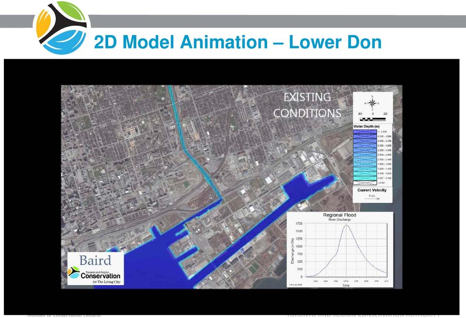
13 2D Model Animation Lower Don
14 Model Types and Model Selection Models only approximate complex natural process Models recognize only their own assumptions Model types are classified according to their dimensionality one dimension (1D) (Unidirectional flow: means variables (velocity, depth, etc.) change predominantly in one defined direction, x, along the channel), two dimensions (2D) (compute the horizontal velocity components (Vx and Vy) or, alternatively, velocity vector magnitude and direction throughout the model domain) Model selection need to consider the compatibility of model assumption and the reality that needs to be approximated or represented
 Model selection need to consider the compatibility of model assumption")
15 Model Types and Model Selection (cont d)
")
16 Model Types and Model Selection (cont d) Model types that TRCA uses HEC-RAS Delft3D Mike Flood (Mike 11 & 21) HEC-RAS MIKE FLOOD MIKE 11 MIKE 21 Delft3D

17 1D Modeling Solves energy. Assumptions, Assumes that flow is parallel to main channels (Unidirectional flow ) Constant Water Surface Elevation on a given cross section: Suitable for: Confined flow and mostly unidirectional No need of detailed velocities With many complex structures

18 1D Modeling (cont d) Advantages, Accurate hydraulic description in rivers with 1D flow; Less computational points relative to 2D model, ie. less computational time; Easy to analyse and extract results Hydraulic structures well represented Disadvantages : Flow paths must be known beforehand; No detailed flow descriptions in floodplains.

19 2D Modeling Solves mass and momentum Assumptions, 2D models make no implicit assumptions about flow direction or magnitude, discharge divisions in splitting channels and the discharge given inflow and outflow elevations can be calculated directly. Suitable for: Flow paths are not well defined or difficulty of visualizing the flow patterns Complex channel-floodplain interaction Threaded rivers and poorly confined flow. Flood Hazard-When detailed velocity and depth patterns are important Complicated nature of overflow along streets and between development Flow attenuation and floodplain storage are significant

20 2D Modeling (cont d) Advantages, Realistic computation of velocities in any direction and determining watershed sheet flow patterns, flow depth -hazard to people Accounts for lateral variation in water surface elevations Better schematization of distributed flow in threaded rivers or unconfined flows Relatively easy to schematise model (i.e can be quick to set up) Beneficial to model impacts of obstructive fill Disadvantages: Costly in computational time; Requires fine grid in rivers/channels in order define conveyance accurately 2D model results are limited by the accuracy of input data Resolution effects may be a problem
 Beneficial to model impacts of obstructive fill Disadvantages: Costly in computational time; Requires fine grid in rivers/channels")
21 1D/2D Coupled Modelling Techniques Coupling helps to take advantage of the benefits from both 1D and 2D; Source:DHI Depiction of a general 1D model of the river channel coupled with a 2D model of the floodplain
22 Data Requirements of 2D Modeling Data requirements of flood inundation models can be categorized in to the following four sections. 1.Topographic data of the channel and floodplain to act as model bathymetry, 2.Time series of bulk flow rates and stage data to provide model input and output boundary conditions, 3.Roughness coefficients for channel and floodplain, which may be spatially distributed, and 4.Observed data for model calibration, and validation
23 Where to put resources? Importance of various aspects related to accuracy of 2D Modeling result Source:RMA2 Manual, 2006
24 Representation of Topography Considerable loss of info. Source: Haile & Rientjes, (2005) What is the appropriate DEM resolution to represent the topography of the study area? Low resolution lead to loss of information High resolution results in excessive computational time Lumping Heterogeneity will be ignored Features like dyke and other flow obstacles will be leveled Local storage areas will diminish Actual flow pattern will be poorly represented.
25 Representation of Topography (cont d) Same Upstream discharge hydrograph Downstream boundary condition Roughness Difference DEM resolution Source: Haile & Rientjes, (2005) Results Wider flood extent with lower resolution DEM.
26 Case Study: Spring Creek Part of Etobicoke Creek Highly urbanized Area Flows not contained within valley 2-dimensional MIKE 21 model developed 2D models better represent overland flow and spilling than 1D models like HEC- RAS 1D/2D Coupling
27 2D Model set-up in MIKE 21 Model Domain-study area Channel and overland flow sections Roughness and features like roads, buildings, river banks and dykes Topographic Data DEM, LiDAR, and HEC-RAS cross section data Hydrological Input Define Inflow location in the study area-upstream flow boundaries Point Sources Boundary exit location stage-discharge relation. Simulation Time step
28 Model domain Initial Improved Model domain includes area between north of Queen Street and Highway 407
29 Model Mesh Triangular Quadrilateral Interpolation of a Bathymetry to the Mesh
30 Topographic Data Sources Overland flow sections Channel flow sections Urban areas: flow dynamics and flood propagation will be greatly affected by features like roads, buildings, river banks and dykes as such they must be accounted for in the model set-up.
31 Roughness Roughness values were defined for the MIKE21 grid based on TRCA s standard manning coefficient Flood obstructive features such buildings were delineated and coded in the model domain
32 3 upstream boundary conditions Hydrographs 1 downstream boundary condition stage discharge curve 7 Point sources Hydrographs Land Boundary Vertical wall Boundary Conditions
33 Simulation of Flood Propagation
34 Maximum Flow Depth
35 Maximum Flow Velocity
36 Comparison of 1D and 2D Outputs
37 Conclusion One-dimensional models provide accurate representation of confined flows. Extent of spill areas can be properly determined using the twodimensional models. Appropriate representation of the topography within the 2D model domain is paramount for the accuracy of 2D model results.
38 Thank you for your time. Contact Information: Sameer Dhalla, P.Eng. Dilnesaw Chekol, PhD.
39 Numerical Modelling Numerical methods will be implemented on a discretized representation of space called either a mesh or grid. Computational efficiency of a numerical model is directly related to the number of equations that need to be solved and therefore to the resolution of the grid. Structured grid Unstructured grid
USING DETAILED 2D URBAN FLOODPLAIN MODELLING TO INFORM DEVELOPMENT PLANNING IN MISSISSAUGA, ON
 22nd Canadian Hydrotechnical Conference 22e Conférence canadienne d hydrotechnique Water for Sustainable Development : Coping with Climate and Environmental Changes L eau pour le développement durable:
MIKE 21 FLOW MODEL HINTS AND RECOMMENDATIONS IN APPLICATIONS WITH SIGNIFICANT FLOODING AND DRYING
 1 MIKE 21 FLOW MODEL HINTS AND RECOMMENDATIONS IN APPLICATIONS WITH SIGNIFICANT FLOODING AND DRYING This note is intended as a general guideline to setting up a standard MIKE 21 model for applications
Appendix C - Risk Assessment: Technical Details. Appendix C - Risk Assessment: Technical Details
 Appendix C - Risk Assessment: Technical Details Page C1 C1 Surface Water Modelling 1. Introduction 1.1 BACKGROUND URS Scott Wilson has constructed 13 TUFLOW hydraulic models across the London Boroughs
1 in 30 year 1 in 75 year 1 in 100 year 1 in 100 year plus climate change (+30%) 1 in 200 year
 1 in 200 year") Appendix C1 Surface Water Modelling 1 Overview 1.1 The Drain London modelling was designed to analyse the impact of heavy rainfall events across each London borough by assessing flow paths, velocities
Appendix C1 Surface Water Modelling 1 Overview 1.1 The Drain London modelling was designed to analyse the impact of heavy rainfall events across each London borough by assessing flow paths, velocities
CHAPTER 9 CHANNELS APPENDIX A. Hydraulic Design Equations for Open Channel Flow
 CHAPTER 9 CHANNELS APPENDIX A Hydraulic Design Equations for Open Channel Flow SEPTEMBER 2009 CHAPTER 9 APPENDIX A Hydraulic Design Equations for Open Channel Flow Introduction The Equations presented
Project Manager. Geoff Masotti, P.Eng. T. 905.940.6161 Ext. 254 T. 905.940.6161 416.987.6161
 Rainbow Creek Master Plan Update Study The City of Vaughan june 2014 COLE ENGINEERING GROUP LTD. 70 Valleywood Drive Project Manager. Geoff Masotti, P.Eng. Markham, ON CANADA L3R 4T5 T. 905.940.6161 Ext.
Quality Assurance Reviews of Hydraulic Models Developed for the Central Valley Floodplain Evaluation and Delineation Program
 Quality Assurance Reviews of Hydraulic Models Developed for the Central Valley Floodplain Evaluation and Delineation Program Techniques Applied and Lessons Learned Seth Ahrens, P.E., CFM Selena Forman,
Interactive comment on A simple 2-D inundation model for incorporating flood damage in urban drainage planning by A. Pathirana et al.
 Hydrol. Earth Syst. Sci. Discuss., 5, C2756 C2764, 2010 www.hydrol-earth-syst-sci-discuss.net/5/c2756/2010/ Author(s) 2010. This work is distributed under the Creative Commons Attribute 3.0 License. Hydrology
FLOODPLAIN DELINEATION IN MUGLA-DALAMAN PLAIN USING GIS BASED RIVER ANALYSIS SYSTEM
 FLOODPLAIN DELINEATION IN MUGLA-DALAMAN PLAIN USING GIS BASED RIVER ANALYSIS SYSTEM Dr. Murat Ali HATİPOĞLU Fatih KESKİN Kemal SEYREK State Hydraulics Works (DSI), Investigation and Planning Department
Appendix 4-C. Open Channel Theory
 4-C-1 Appendix 4-C Open Channel Theory 4-C-2 Appendix 4.C - Table of Contents 4.C.1 Open Channel Flow Theory 4-C-3 4.C.2 Concepts 4-C-3 4.C.2.1 Specific Energy 4-C-3 4.C.2.2 Velocity Distribution Coefficient
Attachment 1 CARRUTHERS CREEK FLOOD MANAGEMENT and ANALYSIS DRAFT TERMS OF REFERENCE
 1.0 INTRODUCTION In early 2010, the Town of Ajax was provided with updated floodplain mapping for Carruthers Creek, based on a Regional Storm event (i.e., Hurricane Hazel), prepared by the Toronto and
AZ EGER-PATAK HIDROLÓGIAI VIZSGÁLATA, A FELSZÍNI VÍZKÉSZLETEK VÁRHATÓ VÁLTOZÁSÁBÓL ADÓDÓ MÓDOSULÁSOK AZ ÉGHAJLATVÁLTOZÁS HATÁSÁRA
 AZ EGER-PATAK HIDROLÓGIAI VIZSGÁLATA, A FELSZÍNI VÍZKÉSZLETEK VÁRHATÓ VÁLTOZÁSÁBÓL ADÓDÓ MÓDOSULÁSOK AZ ÉGHAJLATVÁLTOZÁS HATÁSÁRA GÁBOR KEVE 1, GÉZA HAJNAL 2, KATALIN BENE 3, PÉTER TORMA 4 EXTRAPOLATING
Numerical Modeling and Simulation of Extreme Flood Inundation to Assess Vulnerability of Transportation Infrastructure Assets
 Numerical Modeling and Simulation of Extreme Flood Inundation to Assess Vulnerability of Transportation Infrastructure Assets 2015 University Transportation Center (UTC) Conference for the Southeastern
Using GIS Data With HEC-RAS
 C H A P T E R 14 Using GIS Data With HEC-RAS HEC-RAS has the ability to import three-dimensional (3D) river schematic and cross section data created in a GIS or CADD system. While the HEC- RAS software
USSD Workshop on Dam Break Analysis Applied to Tailings Dams
 USSD Workshop on Dam Break Analysis Applied to Tailings Dams Antecedents Newtonian / non-newtonian flows Available models that allow the simulation of non- Newtonian flows (tailings) Other models used
06 - NATIONAL PLUVIAL FLOOD MAPPING FOR ALL IRELAND THE MODELLING APPROACH
 06 - NATIONAL PLUVIAL FLOOD MAPPING FOR ALL IRELAND THE MODELLING APPROACH Richard Kellagher 1, Mike Panzeri 1, Julien L Homme 1, Yannick Cesses 1, Ben Gouldby 1 John Martin 2, Oliver Nicholson 2, Mark
URBAN DRAINAGE CRITERIA
 URBAN DRAINAGE CRITERIA I. Introduction This division contains guidelines for drainage system design and establishes a policy for recognized and established engineering design of storm drain facilities
How To Understand And Understand The Flood Risk Of Hoang Long River In Phuon Vietnam
 FLOOD HAZARD AND RISK ASSESSMENT OF HOANG LONG RIVER BASIN, VIETNAM VU Thanh Tu 1, Tawatchai TINGSANCHALI 2 1 Water Resources University, Assistant Professor, 175 Tay Son Street, Dong Da District, Hanoi,
CITY UTILITIES DESIGN STANDARDS MANUAL
 CITY UTILITIES DESIGN STANDARDS MANUAL Book 2 (SW) SW9 June 2015 SW9.01 Purpose This Chapter provides information for the design of open channels for the conveyance of stormwater in the City of Fort Wayne.
Environmental Data Management Programs
 Hydrologic Engineering Centre (HEC) Software CD Collection of programs, developed by the U.S. Army Corps of Engineers Environmental Data Management Programs Name: HEC-DSS Package Purpose: Data Storage
Hydrologic Engineering Techniques for Regional Water Resources Planning
 US Army Corps of Engineers Hydrologic Engineering Center Hydrologic Engineering Techniques for Regional Water Resources Planning October 1969 Approved for Public Release. Distribution Unlimited. TP-17
Methods for Determination of Safe Yield and Compensation Water from Storage Reservoirs
 US Army Corps of Engineers Hydrologic Engineering Center Methods for Determination of Safe Yield and Compensation Water from Storage Reservoirs October 1966 Approved for Public Release. Distribution Unlimited.
Sample DEQ Plan Submitter s Checklist for Stormwater Management Plans
 APPENDIX IV Version: February 2, 2015 Sample DEQ Plan Submitter s Checklist for Stormwater Management Plans Please fill in all blanks and please reference the plan sheets/pages where the information may
Innovative Approaches in Flood Damage Reduction
 Innovative Approaches in Flood Damage Reduction Solutions for the Stormwater Management High Level Results 3D geospatial model of storm water management pond (GRCA, 2013) Enhanced understanding of storm
Employing Appropriate Software for Dam break Analysis and Flood Line rendering
 Employing Appropriate Software for Dam break Analysis and Flood Line rendering 1. Background The specialist field of Dam Safety has been developing in SA since about the 80 s. This has led to a well-developed
Modelling Flood Inundation of Urban Areas in the UK Using 2D / 1D Hydraulic Models
 Modelling Flood Inundation of Urban Areas in the UK Using 2D / 1D Hydraulic Models W.J. Syme B.E., M.Eng.Sc. Associate, WBM Pty. Ltd., Australia M.G. Pinnell Bsc Msc MCIWEM Principal Hydrologist, Symonds
Urban Flood Modelling
 Urban Flood Modelling Adrian J Saul Pennine Water Group Department of Civil and Structural Engineering University of Sheffield [email protected] 1 Need for Integrated Urban Drainage within an integrated
Restoration Planning and Development of a Restoration Bank
 Restoration Planning and Development of a Restoration Bank Black Creek Pioneer Village, South Theatre 8:30 a.m. to 3:30 p.m. Habitat Restoration and Environmental Monitoring Projects Section Restoration
Fort Dodge Stormwater Master Planning. Prepared By: Ralph C. Stark, Jr., P.E., C.F.M. Joel N. Krause, P.E., C.F.M.
 Fort Dodge Stormwater Master Planning Prepared By: Ralph C. Stark, Jr., P.E., C.F.M. Joel N. Krause, P.E., C.F.M. Project Location Project Background Flooding History Localized flooding and storm sewer
Travel Time. Computation of travel time and time of concentration. Factors affecting time of concentration. Surface roughness
 3 Chapter 3 of Concentration and Travel Time Time of Concentration and Travel Time Travel time ( T t ) is the time it takes water to travel from one location to another in a watershed. T t is a component
Section 5 Floodplain Management Tools
 5.1 Floodprone Areas One of the major elements of the Master Plan is the updated 100-year floodplain and floodway boundary maps. This information provided the most up-to-date tools to protect homes and
City of London Climate Change Adaptation Strategy Dealing with Extreme Rainfall Events
 City of London Climate Change Adaptation Strategy Dealing with Extreme Rainfall Events May 29, 2014 Presented by: Berta Krichker M.Eng., FEC, P.Eng. Manager of Stormwater Unit Environmental and Engineering
Impact of water harvesting dam on the Wadi s morphology using digital elevation model Study case: Wadi Al-kanger, Sudan
 Impact of water harvesting dam on the Wadi s morphology using digital elevation model Study case: Wadi Al-kanger, Sudan H. S. M. Hilmi 1, M.Y. Mohamed 2, E. S. Ganawa 3 1 Faculty of agriculture, Alzaiem
Geoprocessing Tools for Surface and Basement Flooding Analysis in SWMM
 3 Geoprocessing Tools for Surface and Basement Flooding Analysis in SWMM Eric White, James Knighton, Gary Martens, Matthew Plourde and Rajesh Rajan A geoprocessing routine was used for the development
The Alternatives of Flood Mitigation in The Downstream Area of Mun River Basin
 The Alternatives of Flood Mitigation in The Downstream Area of Mun River Basin Dr.Phattaporn Mekpruksawong 1, Thana Suwattana 2 and Narong Meepayoong 3 1 Senior Civil Engineer, Office of Project Management,
How To Develop A Flood Risk Map
 Recommended Procedures for Flood Velocity Data Development November 2012 Federal Emergency Management Agency Department of Homeland Security 500 C Street, SW Washington, DC 20472 This document was prepared
Modelling of Urban Flooding in Dhaka City
 Modelling of Urban Flooding in Dhaka City Chusit Apirumanekul*, Ole Mark* *Water Engineering & Management, Asian Inst. of Technology, PO Box 4, Klong Luang, Pathumthani 12120, Thailand Abstract Flooding
ROSE CREEK WATERSHED HYDROLOGIC, HYDRAULIC, SEDIMENT TRANSPORT, AND GEOMORPHIC ANALYSES TASK 1 EXISTING DATA AND INFORMATION SUMMARY REPORT BACKGROUND
 ROSE CREEK WATERSHED HYDROLOGIC, HYDRAULIC, SEDIMENT TRANSPORT, AND GEOMORPHIC ANALYSES TASK 1 EXISTING DATA AND INFORMATION SUMMARY REPORT BACKGROUND The Rose Creek Watershed (RCW) consists of three planning
2.0 BASIC CONCEPTS OF OPEN CHANNEL FLOW MEASUREMENT
 2.0 BASIC CONCEPTS OF OPEN CHANNEL FLOW MEASUREMENT Open channel flow is defined as flow in any channel where the liquid flows with a free surface. Open channel flow is not under pressure; gravity is the
Interim Technical Guidelines for the Development of Environmental Management Plans for Underground Infrastructure Revised - July 2013.
 Interim Technical Guidelines for the Development of Environmental Management Plans for Underground Infrastructure Revised - July 2013 Rationale Underground infrastructure may be at risk from valley, streambank
MIKE 21 Flow Model FM. Parallelisation using GPU. Benchmarking report
 MIKE 21 Flow Model FM Parallelisation using Benchmarking report MIKE by DHI 2014 DHI headquarters Agern Allé 5 DK-2970 Hørsholm Denmark +45 4516 9200 Telephone +45 4516 9333 Support +45 4516 9292 Telefax
SIMPLIFIED INUNDATION MAPS FOR EMERGENCY ACTION PLANS. National Dam Safety Review Board Emergency Action Plan Workgroup
 SIMPLIFIED INUNDATION MAPS FOR EMERGENCY ACTION PLANS National Dam Safety Review Board Emergency Action Plan Workgroup EXECUTIVE SUMMARY Development of Emergency Action Plans (EAPs) for all high and significant
HEC-RAS. River Analysis System. Applications Guide. Version 4.1 January 2010. US Army Corps of Engineers Hydrologic Engineering Center CPD-70
 US Army Corps of Engineers Hydrologic Engineering Center HEC-RAS HEC-RAS River Analysis System Applications Guide Version 4.1 January 2010 Approved for Public Release. Distribution Unlimited CPD-70 REPORT
A Flood Warning System for City of Findlay, Ohio
 A Flood Warning System for City of Findlay, Ohio Matt Whitehead US Geological Survey, Ohio Water Science Center 6480 Doubletree Avenue Columbus, Ohio 43229 Abstract The U.S. Geological Survey (USGS) and
How to Read a Flood Insurance Rate Map Tutorial. Developed September 2000 Updated June 2003
 How to Read a Flood Insurance Rate Map Tutorial Developed September 2000 Updated June 2003 Learning Objectives: The Objectives of the tutorial are: 1. To show the various types of flood maps, 2. To describe
DANIELS RUN STREAM RESTORATION, FAIRFAX, VIRGINIA: FLOODPLAIN ANALYSIS REPORT
 DANIELS RUN STREAM RESTORATION, FAIRFAX, VIRGINIA: FLOODPLAIN ANALYSIS REPORT By: Conor C. Shea Stream Habitat Assessment and Restoration Program U.S. Fish and Wildlife Service CBFO-S07-01 Prepared in
Application of Google Earth for flood disaster monitoring in 3D-GIS
 Disaster Management and Human Health Risk II 271 Application of Google Earth for flood disaster monitoring in 3D-GIS M. Mori & Y. L. Chan Department of Information and Computer Science, Kinki University,
Basic Hydrology. Time of Concentration Methodology
 Basic Hydrology Time of Concentration Methodology By: Paul Schiariti, P.E., CPESC Mercer County Soil Conservation District What is the Time of Concentration? The time it takes for runoff to travel from
5.14 Floodplains and Drainage/Hydrology
 I-70 East Final EIS 5.14 Floodplains and Drainage/Hydrology 5.14 Floodplains and Drainage/Hydrology This section discusses floodplain and drainage/hydrology resources and explains why they are important
Estimating Potential Reduction Flood Benefits of Restored Wetlands
 Estimating Potential Reduction Flood Benefits of Restored Wetlands Kenneth W. Potter University of Wisconsin Introduction Throughout the summer of 1993 a recurring question was the impact of wetland drainage
TOPOGRAPHIC DATA AND ROUGHNESS PARAMETERISATION EFFECTS ON 1D FLOOD INUNDATION MODELS. Supervisor: S. Anders Brandt Examinator: Bo Malmström
 TOPOGRAPHIC DATA AND ROUGHNESS PARAMETERISATION EFFECTS ON 1D FLOOD INUNDATION MODELS by Nancy Joy Lim Supervisor: S. Anders Brandt Examinator: Bo Malmström 1 OUTLINE I. Introduction II. Study Area III.
Guide To Bridge Planning Tools
 Guide To Bridge Planning Tools The following bridge planning and hydrotechnical analysis tools (Excel spreadsheets, some with associated databases and VBA code), and GIS data-sets are available from the
DEVELOPING AN INUNDATION MAP STANDARD FOR THE U.S. ARMY CORPS OF ENGINEERS
 DEVELOPING AN INUNDATION MAP STANDARD FOR THE U.S. ARMY CORPS OF ENGINEERS Will Breitkreutz, Geographer, U.S. Army Corps of Engineers Kansas City District, Kansas City, Missouri, [email protected]
Catchment Scale Processes and River Restoration. Dr Jenny Mant [email protected]. The River Restoration Centre therrc.co.uk
 Catchment Scale Processes and River Restoration Dr Jenny Mant [email protected] The River Restoration Centre therrc.co.uk 3 Main Catchment Elements Hydrology Energy associated with the flow of water affects
Flood Modelling for Cities using Cloud Computing FINAL REPORT. Vassilis Glenis, Vedrana Kutija, Stephen McGough, Simon Woodman, Chris Kilsby
 Summary Flood Modelling for Cities using Cloud Computing FINAL REPORT Vassilis Glenis, Vedrana Kutija, Stephen McGough, Simon Woodman, Chris Kilsby Assessment of pluvial flood risk is particularly difficult
Chapter 13 OPEN-CHANNEL FLOW
 Fluid Mechanics: Fundamentals and Applications, 2nd Edition Yunus A. Cengel, John M. Cimbala McGraw-Hill, 2010 Lecture slides by Mehmet Kanoglu Copyright The McGraw-Hill Companies, Inc. Permission required
Please click on the tutorial most fitting of your expertise in order to learn about the features of the visualization tool.
 Introduction Welcome to the Indian Creek Conservation Reserve Program (CRP) visualization tool. This tool was developed by the University of Iowa - Institute for Hydroscience and Research (IIHR) as part
GIS APPLICATIONS IN URBAN DRAINAGE MASTER PLANNING. Robert J. Muir *
 GIS APPLICATIONS IN URBAN DRAINAGE MASTER PLANNING Robert J. Muir * ABSTRACT: In recent years, GIS applications in water resources management have become widespread and diverse in the Province of Ontario,
Hydrologic Modeling using HEC-HMS
 Hydrologic Modeling using HEC-HMS Prepared by Venkatesh Merwade School of Civil Engineering, Purdue University [email protected] April 2012 Introduction The intent of this exercise is to introduce you
ECONOMIC ANALYSIS FLOOD DAMAGE REDUCTION. Lower Carmel River Floodplain Restoration and Enhancement Project
 ECONOMIC ANALYSIS FLOOD DAMAGE REDUCTION Lower Carmel River Floodplain Restoration and Enhancement Project I. Description of the Project and its Relationship to Other Projects in the Proposal The Lower
Flow Through an Abrupt Constriction. 2D Hydrodynamic Model Performance and Influence of Spatial Resolution
 Flow Through an Abrupt Constriction 2D Hydrodynamic Model Performance and Influence of Spatial Resolution Cathie Louise Barton BE (Civil) School of Environmental Engineering Faculty of Environmental Sciences
Groundwater Flooding: a UK Perspective
 Groundwater Flooding: a UK Perspective David Macdonald British Geological Survey Maclean Building Crowmarsh Gifford Wallingford OX10 8BB Tel 01491 838800 NERC All rights reserved Talk outline Definition
UNION COUNTY, FLORIDA AND INCORPORATED AREAS
 UNION COUNTY, FLORIDA AND INCORPORATED AREAS COMMUNITY NAME COMMUNITY NUMBER LAKE BUTLER, CITY OF 120595 RAIFORD, TOWN OF 120593 UNION COUNTY 120422 (UNINCORPORATED AREAS) WORTHINGTON SPRINGS, CITY OF
Emergency Spillways (Sediment basins)
") Emergency Spillways (Sediment basins) DRAINAGE CONTROL TECHNIQUE Low Gradient Velocity Control Short-Term Steep Gradient Channel Lining Medium-Long Term Outlet Control Soil Treatment Permanent [1] [1]
Emergency Spillways (Sediment basins) DRAINAGE CONTROL TECHNIQUE Low Gradient Velocity Control Short-Term Steep Gradient Channel Lining Medium-Long Term Outlet Control Soil Treatment Permanent [1] [1]
Understanding Complex Models using Visualization: San Bernardino Valley Ground-water Basin, Southern California
 Understanding Complex Models using Visualization: San Bernardino Valley Ground-water Basin, Southern California Zhen Li and Wesley R. Danskin U.S. Geological Survey, [email protected], [email protected],
ADDING VALUE TO BOM FLOOD PREDICTIONS (WITHOUT MESSING AROUND WITH MODELS)
") ADDING VALUE TO BOM FLOOD PREDICTIONS (WITHOUT MESSING AROUND WITH MODELS) Mark Babister Steve Opper Peter Cinque Matthew Chadwick Belinda Davies Director, Webb McKeown & Associates Director, Emergency
ADDING VALUE TO BOM FLOOD PREDICTIONS (WITHOUT MESSING AROUND WITH MODELS) Mark Babister Steve Opper Peter Cinque Matthew Chadwick Belinda Davies Director, Webb McKeown & Associates Director, Emergency
FLOOD INFORMATION SERVICE EXPLANATORY NOTES
 FLOOD INFORMATION SERVICE EXPLANATORY NOTES Part 1 About the flood maps Limitations of the mapping What the maps don t show Where to find more information Definitions of words used to describe flooding.
HYDROLOGIC/HYDRAULIC MODELING OF WESTMINSTER WATERSHED ORANGE COUNTY, CALIFORNIA
 HYDROLOGIC/HYDRAULIC MODELING OF WESTMINSTER WATERSHED ORANGE COUNTY, CALIFORNIA James Chieh, Ph.D., P.E., Senior Hydraulic Engineer, USACE, Los Angeles, California, [email protected]; Jay Pak,
Enhanced DEM-based flow path delineation algorithms for urban drainage modelling
 Enhanced DEM-based flow path delineation algorithms for urban drainage modelling João Paulo Leitão, S. Boonya-aroonnet, D. Prodanović and Č. Maksimović Belo Horizonte, Brasil October, 2009 Outline Urban
BLACK/HARMONY/FAREWELL CREEK WATERSHED EXISTING CONDITIONS REPORT CHAPTER 12 - STORMWATER MANAGEMENT
 Harmony Creek subwatershed Harmony Creek subwatershed BLACK/HARMONY/FAREWELL CREEK WATERSHED EXISTING CONDITIONS REPORT CHAPTER 12 - STORMWATER MANAGEMENT April 2011 TABLE OF CONTENTS 1.0 INTRODUCTION...
CHICKASAW COUNTY, MISSISSIPPI, AND INCORPORATED AREAS
 CHICKASAW COUNTY, MISSISSIPPI, AND INCORPORATED AREAS Chickasaw County Community Name Community Number CHICKASAW COUNTY 280269 (UNINCORPORATED AREAS) HOUSTON, CITY OF 280030 NEW HOULKA, TOWN OF 280067
Prepared by. Drew Davidge
 Flood Damage Estimation in the Upper Thames River Watershed CFCAS project: Assessment of Water Resources Risk and Vulnerability to Changing Climatic Conditions Project Report VII. August 2005 Prepared
Prattsville Berm Removal Project. 1.0 Project Location
 Prattsville Berm Removal Project 1.0 Project Location The project site is located between the New York State Route 23 Bridge over the Schoharie Creek and the Schoharie Reservoir. The restoration plan encompassed
Appendix F Benefit-Cost Analysis of Flood Protection Measures
 Appendix F Benefit-Cost Analysis of Flood Protection Measures Acronyms used in Appendix F: AA B AA C AA D BC BFE EAD FEMA NED O&M PV RED USACE Average Annual Benefits Average Annual Cost Average Annual
Latornell. Experiments in Climate Change Response in a Rapidly Urbanizing Region. November 20, 2008. By Brian Denney Chief Administrative Officer
 Latornell Experiments in Climate Change Response in a Rapidly Urbanizing Region November 20, 2008 By Brian Denney Chief Administrative Officer Toronto has an ecological footprint 280 times its Eric Krause
ANALYSIS OF A ANTROPIC INFLUENCES IN A FLOODPLAN
 ANALYSIS OF A ANTROPIC INFLUENCES IN A FLOODPLAN M.C.S. Pereira 1&2 ; J.R.S. Martins 1 ; R.M. Lucci 2 and L.F.O.L, Yazaki 2 1. Escola Politécnica da Universidade de São Paulo, Brazil 2. Fundação Centro
COMPARING DSS-WISE- LITE TO OTHER DAM BREACH SOFTWARE
 National Dam Safety Program Technical Seminar No. 22 Dam Breach Modeling and Consequence Assessment National Emergency Training Center February 18-19, 2015 Emmitsburg, MD Brian Shane Cook, PE, LSIT formerly
Flooding in Urban Areas - 2D Modelling Approaches for Buildings and Fences
 Flooding in Urban Areas - 2D Modelling Approaches for Buildings and Fences W.J. Syme BE Civil Hons), MEngSc Res), BMT WBM Pty Ltd, 490 Upper Edward St, Brisbane, Qld, 4000, [email protected] Abstract:
Exercise (4): Open Channel Flow - Gradually Varied Flow
: Open Channel Flow - Gradually Varied Flow") Exercise 4: Open Channel Flow - Gradually Varied Flow 1 A wide channel consists of three long reaches and has two gates located midway of the first and last reaches. The bed slopes for the three reaches
Exercise 4: Open Channel Flow - Gradually Varied Flow 1 A wide channel consists of three long reaches and has two gates located midway of the first and last reaches. The bed slopes for the three reaches
A Method Using ArcMap to Create a Hydrologically conditioned Digital Elevation Model
 A Method Using ArcMap to Create a Hydrologically conditioned Digital Elevation Model High resolution topography derived from LiDAR data is becoming more readily available. This new data source of topography
Abaya-Chamo Lakes Physical and Water Resources Characteristics, including Scenarios and Impacts
 LARS 2007 Catchment and Lake Research Abaya-Chamo Lakes Physical and Water Resources Characteristics, including Scenarios and Impacts Seleshi Bekele Awulachew International Water Management Institute Introduction
rescue and relief efforts in the aftermath of flooding, (iii) repair of flood damaged public facilities and utilities, and
 repair of flood damaged public facilities and utilities, and") 1. Purpose (1) It is the purpose of this Ordinance to protect human life, health, and property from flood conditions, to preserve the ability of floodplains to carry and discharge a base flood, and to
1. Purpose (1) It is the purpose of this Ordinance to protect human life, health, and property from flood conditions, to preserve the ability of floodplains to carry and discharge a base flood, and to
The answers to some of the following questions are separated into two major categories:
 Following the recent flooding events for Front Range communities in Colorado, property owners, communities, and the National Flood Insurance Program are being presented with some new challenges in the
Flash Flood Science. Chapter 2. What Is in This Chapter? Flash Flood Processes
 Chapter 2 Flash Flood Science A flash flood is generally defined as a rapid onset flood of short duration with a relatively high peak discharge (World Meteorological Organization). The American Meteorological
UTILITIZATION OF ECOHYDROLOGIC MODELS IN FLOODPLAIN FISH PASSAGE AND HABITAT RESTORATION EVALUATION
 UTILITIZATION OF ECOHYDROLOGIC MODELS IN FLOODPLAIN FISH PASSAGE AND HABITAT RESTORATION EVALUATION Joshua A. Israel, Fish Biologist, U.S Bureau of Reclamation, Sacramento, CA. [email protected]; Paul
Lower Raritan Watershed Management Area Stormwater & Flooding Subcommittee Strategy Worksheet LRSW-S3C1
 Strategy Name: Reduce Existing Potential for Flood Damages LRSW-S3C1. Develop and implement a program to: Minimize flood damages through the use of structural measures. Minimize flood damages through the
DETERMINISTIC HYDROLOGICAL MODELING AND GRID SIZE SENSITIVITY ANALYSIS FOR FLOOD RISK ASSESSMENT OF MEXICO CITY
 Netherlands E-proceedings of the 36 th IAHR World Congress 28 June 3 July, 2015, The Hague, the DETERMINISTIC HYDROLOGICAL MODELING AND GRID SIZE SENSITIVITY ANALYSIS FOR FLOOD RISK ASSESSMENT OF MEXICO
Topic 8: Open Channel Flow
 3.1 Course Number: CE 365K Course Title: Hydraulic Engineering Design Course Instructor: R.J. Charbeneau Subject: Open Channel Hydraulics Topics Covered: 8. Open Channel Flow and Manning Equation 9. Energy,
10/4/2012. 40 slide sample of Presentation. Key Principles to Current Stormwater Management
 40 slide sample of Presentation Please contact [email protected] if you would like the complete presentation Key Principles to Current Stormwater Management Distributed Control Measures Integrated
CHAPTER 3 STORM DRAINAGE SYSTEMS
 CHAPTER 3 STORM DRAINAGE SYSTEMS 3.7 Storm Drains 3.7.1 Introduction After the tentative locations of inlets, drain pipes, and outfalls with tail-waters have been determined and the inlets sized, the next
HYDROGRAPH ROUTING. E. Input data needed for channel routing include the inflow hydrograph and the channel characteristics
 HYDROGRAPH ROUTING. Introduction A. Two Types of Hydrograph Routing. Storage or Reservoir Routing. Channel Routing B. Reservoir Routing is used to determine the peak-flow attenuation that a hydrograph
Modelling floods and damage assessment using GIS
 HydroGIS 96: Application of Geographic Information Systems in Hydrology and Water Resources Management (Proceedings of the Vienna Conference, April 1996). IAHS Publ. no. 235, 1996. 299 Modelling floods
Managing sewer flood risk
 Managing sewer flood risk J. Ryu 1 *, D. Butler 2 1 Environmental and Water Resource Engineering, Department of Civil and Environmental Engineering, Imperial College, London, SW7 2AZ, UK 2 Centre for Water
LYNDE CREEK WATERSHED EXISTING CONDITIONS REPORT CHAPTER 12 - STORMWATER MANAGEMENT
 Whitby CLOCA Whitby CLOCA LYNDE CREEK WATERSHED EXISTING CONDITIONS REPORT CHAPTER 12 - STORMWATER MANAGEMENT June 2008 TABLE OF CONTENTS 1.0 INTRODUCTION... 3 2.0 STUDY AREA AND SCOPE... 4 3.0 METHODOLOGY...
TENNESSEE GAS PIPELINE COMPANY, L.L.C.
 TENNESSEE GAS PIPELINE COMPANY, L.L.C. HYDROLOGIC & HYDRAULIC CALCULATIONS FOR WATERBODIES CROSSED BY CONNECTICUT PIPELINE EXPANSION PROJECT CONNECTICUT LOOP Submitted by: Tennessee Gas Pipeline Company,