Creation of Soil Liquefaction Susceptibility Maps for San Luis Obispo & Marin Counties using Geographic Information Systems.
|
|
|
- Alan Webster
- 8 years ago
- Views:
Transcription
1 Creation of Soil Liquefaction Susceptibility Maps for San Luis Obispo & Marin Counties using Geographic Information Systems. Amelia M. Lowman December 2009 Dr. Lynn E. Moody Adviser Earth and Soil Sciences Department California Polytechnic State University San Luis Obispo, California

2 Table of Contents LIST OF TABLES... ii LIST OF FIGURES... ii ABSTRACT... iii ACKNOWLEDGEMENTS... iv INTRODUCTION... 1 LITERATURE REVIEW... 2 MATERIALS AND METHODS... 3 RESULTS & DISCUSSION CONCLUSION REFERENCES... 16

3 LIST OF TABLES Table 1 Youd and Perkins Liquefaction Criteria Table 2 Criteria used to convert USGS Lithographic and County Geologic Layers Figure 1 Study Area LIST OF FIGURES Figure 2 GIS Model Builder used to Intersect Layers Figure 3 Example of Pre-Pleistocene Selection using ArcGIS Model Builder Figure 4 Final Layer Selection Process using ArcGIS Figure 5 SLO County Liquefaction Risk Map using GIS Figure 6 Marin County Liquefaction Risk Map using GIS Figure 7 Oceano Liquefaction Locations Figure 8 Marin County Liquefaction Locations ii

4 ABSTRACT Liquefaction of soils in response to earthquake shaking is a pressing issue in the state of California. Using Geographic Information Systems, Geological and lithology layers, along with criteria in order to separate out the data into four risk categories, a liquefaction risk assessment map was created for San Luis Obispo and Marin Counties. The accuracy of these maps was then assessed using liquefaction occurrences for San Luis Obispo County, and it was determined that while the map is somewhat accurate, in order to obtain a greater amount of accuracy and increase the usefulness of these maps, more data would need to be obtained, analyzed, and included in each of the County Map Layers. iii

5 ACKNOWLEDGEMENTS I would like to thank my parents, who have supported me unconditionally from the start of this journey, my Halcyon family, who also kept me going with their enthusiasm and encouragement. Kristel & Evin who helped me stay focused and also supported me. Thank you to the whole Earth Sciences department for being so welcoming and community oriented. This department has something very special, and I am grateful to be part of it. Thank you to Dr. Moody, Dr. Smith, Dr. Appel, Dr. Rice, and Dr. Garcia, and all my fellow Earth Science Majors. Each of you was a friendly face in the hall, or in The Rock, encouraging me and helping me learn so much. I couldn t have done it without any of you. iv

6 INTRODUCTION Soil liquefaction is the response to shaking of the soils where the soil grains move as though they are a liquid instead of solid. Soil liquefaction causes property damage to buildings and utilities, which can be costly to counties. This study seeks to simplify the mapping of potentially liquefiable soils by using Geographical Information Systems (GIS), and the geologic age layers created by the USGS to produce a map which could be used to evaluate potential damage in high risk areas of the county. Using GIS in order to map the liquefaction potential of soils for different counties could allow these counties to amend building codes in susceptible areas, allowing better damage preparation. Liquefaction can create problems such as sinking houses, trapped occupants and disrupted utilities within the counties where earthquakes occur (Arulmoli et al, 1999). Cone penetration tests are used by the USGS in order to create GIS maps (Holzer et al, 2004), but this is costly and not every county can afford to fund such studies. Geologic GIS layers are available due to the soil mapping of most counties by the USGS. Using the age of the rocks in the county, along with other available data layers to narrow down the liquefaction risk of areas within the counties, could provide a less expensive mapping alternative to the cone penetration test type mapping. Using ArcMap, and liquefaction criteria, the geologic GIS layers for each of the three counties were modeled to select out the most liquefiable areas. These data layers were then combined to create a liquefaction risk map for each of the three counties. 1

7 LITERATURE REVIEW Liquefaction of soils causes property damages to buildings built on top of susceptible areas. Liquefaction is the movement of soils caused by effects of the shaking of soils during a ground moving event such as an earthquake. This damage could be avoided if older buildings found to be on liquefiable soils are retrofitted. (Holzer, et al 2004). Underground pipelines and wiring are also damaged when the ground shifts, costing these counties money to pay for damage repair. Locally, the city of Oceano has been affected by the liquefaction of soils after the 2003 San Simeon earthquake. (Holtzer, et al, 2004) Marin Counties also are subject to earthquakes, and coastal, which makes them a good fit for this study. Youd and Perkins (1978), show that geologic maps of liquefaction susceptibility can be created using data collected at the surface. Historically, most cases of earthquakeinduced liquefaction have occurred in alluvial deposits of loose silty sands (Yamamuro, 1999). Criteria for the assessment of liquefaction from this study were applied to making the liquefaction maps. 2

8 MATERIALS AND METHODS For this study, the following websites were used to obtain GIS layers for each county. 1. CA Geologic Map Data ( The shapefile for the Geologic Lithographic Units of California was obtained from this site. This layer was later combined with each of the individual county boundary layers. 2. SLO DataFinder ( Layers obtained from this site are the county boundary, geologic information, and water bodies within the county. 3. Marin Map ( The Marin County Geology information layer was obtained, along with the county boundary layer. Materials: The materials used for this study include ESRI ArcGIS Software, GIS data layers from the USGS, a desktop computer, and the NRCS Soil Survey studies for San Luis Obispo and Marin counties. 3
 The Marin County Geology information layer was obtained, along with the county boundary layer.")
9 Study Area: The study area for this project consists of Marin and San Luis Obispo Counties. (Fig.1) Both counties lie within the California Coast and the surface geology of these counties consists mostly of sedimentary layers. San Luis Obispo and Marin counties also have numerous local faults. High sand concentrations and potentially more liquefiable soils than other areas in the state create liquefaction hazards, with earthquake hazards, which put the counties at risk for damage. (Hinds et al, 2005) Figure 1: Red Shade indicates study area 4

10 Software: For this study, ArcGIS was used, along with ArcToolbox in order to edit the shapefiles, and model builder was used in order to single out each risk layer according to the liquefaction criteria used in this study. Geology: The USGS state geological surface geology layer consists of a shapefile containing the geologic age of the surface geology in the entire state. The surface geology layers are dated from Miocene to Holocene, and the lithology is stated in the shapefile attribute table. This information was combined with the county layers, giving a more complete geologic profile to the counties. GIS Layers: ArcView Shapefile layers were obtained from SLO data finder for San Luis Obispo County and the USGS website for the geologic lithology layer for the whole state of CA. The Geologic layers are of the UTM Zone 10, Northern Hemisphere (NAD 83) coordinate system. The USGS state lithographic layer is in the North American 1927 coordinate system and was transformed into the NAD 1983 coordinate system using ArcGIS in order to match the other layers used for each county. For San Luis Obispo and Marin County, the county boundary layer, geologic layer, and the USGS lithology layer were imported into Using ArcGIS model builder, the county boundary layer was combined with the USGS lithology layer using ArcToolbox using the Overlay and then the Intersect commands (Fig 2). 5


11 Figure 2 GIS Model Builder used to Intersect Layers This process outputs a layer that has the lithology information for just the county instead of the entire state while preserving the coastline of each county. Merging the different layers was necessary in order to get all of the shapefile data associated with each county onto one workable layer. The resulting merged layer was then used to narrow down the attributes found to contribute to liquefaction into the four risk categories; High, Medium, Low, and Very Low risk for liquefaction, based on the Youd and Perkins Criteria. Pre-Pleistocene rocks are generally considered very low risk for liquefaction (Youd and Idriss, 2001). Using these criteria, all of the Pre-Pleistocene rocks in the geologic information layers for each county were selected for using the ArcGIS model builder select function. Selecting for the rock layers created most of the Very Low Risk layer for each county. This process was repeated using the USGS lithographic layer in order to assure that all Pre-Pleistocene rock units were selected for (Fig.3). 6
.")

12 Figure 3 Example of Pre-Pleistocene Selection using ArcGIS Model Builder 7

13 Table 1.Youd and Perkins (1978) Liquefaction Criteria 8
")
14 Using the Youd and Perkins criteria (Table 1), the individual rock units in each county were classified by risk type using ArcGIS model builder to separate each group out into a layer of either VL, L, M or H liquefaction risk (Table 2). Table 2 Criteria used to convert USGS Lithographic and County Geologic Layers Risk Very Low Low Moderate High Rock Types and Age Associated with each Risk Type Older than Pleistocene Rock Layers. Pleistocene dunes. Quaternary Old alluvium, Jurassic, Cretaceous or Quaternary and Tertiary combined as the prefix. Pleistocene rock layers. Holocene estuary, alluvial fan, marine terrace, volcanic rocks. Td (Talus). Quaternary sands, Quaternary Land Slides, dune sand. Pleistocene to Holocene dune sands. Recent Dunes, Recent Riverbeds, Recent Alluvial Fan, Coastal River Delta, Quaternary young alluvium, Quaternary Young Alluvium and Quaternary Sands mixed. Quaternary Artificial Fill. In Marin County, the artificial fill is known to be high risk of liquefaction (Hinds, 2005). Rock descriptions (Churchill, 2008) were also utilized for each county in order to further separate out the categories for each rock unit type. For each of the three counties, 4 individual risk shapefile layers were then added onto the same document, along with other relevant layers such as water bodies, in order to create the liquefaction risk map (Fig.4). In order to assess the accuracy of this study, actual liquefaction locations were imported for each county. For San Luis Obispo County, the areas in Oceano that liquefied during the 2003 San Simeon Earthquake were digitized using ArcGIS Georeferencing, and placed onto the finished Liquefaction Risk Assessment Map for San Luis Obispo County (Fig.8). 9


15 Figure 4 Final Layer Selection Process using ArcGIS 10

16 RESULTS & DISCUSSION SLO County The resulting map (Fig.5) shows potential liquefaction areas in each of the counties. In San Luis Obispo County, the most liquefiable areas are composed of Holocene riverbeds or dune sands. Most of the county is on Pre-Pleistocene bedrock which is seen as a very low risk for liquefaction. Looking at the NRCS soil survey layers, high liquefaction risk areas are areas where sandy beaches, dunes or the Baywood Soil Type occurs. Moderate areas tended to consist mostly of Tierra Soils, Conception Loam, Chamis Shaly Loam, and Elder flooded sandy loam. (NRCS SLO) A map comparing the actual occurrence of liquefaction in Oceano, CA to the map created in this study was made in order to help assess the accuracy of this study (Fig.6). Marin County In Marin County, the most liquefiable areas were determined to be coastal areas of artificial fill on top of muds, and Holocene beach sands. Most of the area is on Pre- Pleistocene rock units which are not highly liquefiable (Fig.7). 11

17 Figure 5 SLO County Liquefaction Risk Map using GIS 12

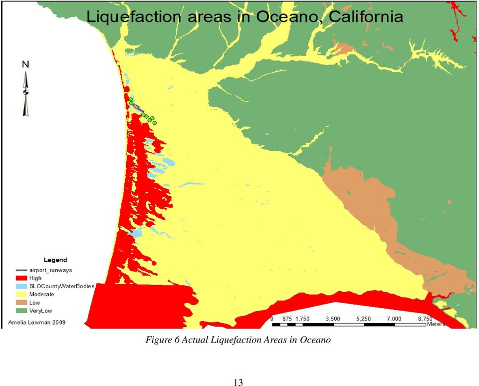
18 Figure 6 Actual Liquefaction Areas in Oceano 13
19 Figure 7 Marin County Liquefaction Risk Map using GIS 14

20 CONCLUSION Using GIS in order to create liquefaction maps requires complete, accurate data, and criteria. Comparing the risk assessment map to the actual liquefied areas in Oceano on the San Luis Obispo County Map, the area is shown as moderately liquefiable when in reality it seems to be highly liquefiable (Fig.6). The maps created for this study were created only using lithographic GIS layers, along with the NRCS soils information (NRCS SLO). In order to be more accurate, this study would have to take into account water table depth, soil bore hole data for each county, and for even more accuracy, a USGS shaker truck that would record the movement of the soils as they are shaken by the equipment on the trucks. The maps created in this study could be a good general guideline, but until more data such as bore-hole soil information, and water table depths are added to the map layers, they should not be viewed as perfectly accurate for the counties represented. 15

21 REFERENCES K. Arulmoli, J.I. Baez, T.F. Blake, J. Earnest, F. Gharib, J. Goldhammer, D. Hsu, S. Kupferman, J. O Tousa, C.R. Real, W. Reeder, E. Simantob, and T.L. Youd Recommended Procedures for Implementation of DMG Special Publication 117 Guidelines for Analyzing and Mitigating Liquefaction Hazards in California, Southern California Earthquake Center, University of Southern California Churchill, R Radon Potential in San Luis Obispo County. California Geological Survey, Department of Conservation. Compton, R Geology in the field. John Wiley & Sons Inc, New York Hinds, A.,Rodriquez, M., Vogler, F., Dawson,D., Drumm, K., Allee, D Geology, Mineral Resources and Hazardous Materials Technical Background Report Holzer et al, 2004 Liquefaction-Induced Lateral Spreading in Oceano, California, During the 2003 San Simeon Earthquake Jahns, Richard H Preliminary geologic map of the Chise quadrangle, Sierra County, New Mexico. NRCS Soil Survey Report for San Luis Obispo County, U.S. Department of Agriculture, Natural Resources Conservation Service. NRCS Soil Survey Report, Marin County, 2007, U.S. Department of Agriculture, Natural Resources Conservation Service. Yamamuro, J, Hade, V Experiments and modeling of silty sands susceptible to static Liquefaction. Mechanics of Cohesive-Frictional Materials. Mech. Cohesive.-Frictional. Material. 4, Youd,T, and Idriss, I.M., Liquefaction Resistance of Soils: Summary Report From The 1996 NCEER and 1998 NCEER/NSF Workshops on Evaluation of Liquefaction Resistance of Soils. Journal of Geotechnical and GeoEnvironmental Engineering. p.309 Youd and Perkins Liquefaction risk factors of sedimentary deposits. Journal of Geotechnical and Geo-environmental Engineering. p
4.6 GEOLOGIC AND SEISMIC HAZARDS
 4.6 GEOLOGIC AND SEISMIC HAZARDS This Section describes the current conditions relating to the geologic and seismic characteristics of the City of Cypress. This Section concludes with an analysis of geologic
CONE PENETRATION TESTING AND SITE EXPLORATION IN EVALUATING THE LIQUEFACTION RESISTANCE OF SANDS AND SILTY SANDS ABSTRACT
 CONE PENETRATION TESTING AND SITE EXPLORATION IN EVALUATING THE LIQUEFACTION RESISTANCE OF SANDS AND SILTY SANDS E. J. Newman 1, T. D. Stark 2, and S. M. Olson 3 ABSTRACT Refined relationships between
Chapter 7 Analysis of Soil Borings for Liquefaction Resistance
 Chapter 7 Analysis of Soil Borings for Liquefaction Resistance 7.1. Introduction. This chapter addresses the analysis of subsurface soil data to determine the factor of safety against liquefaction and
STABILITY ANALYSIS OF AN EARTH DAM FOUNDATION IN TUNISIA
 Int. J. of GEOMATE, June, 1, Vol., No. (Sl. No. 1), pp. 919-9 Geotech., Const. Mat. & Env., ISSN:1-9(P), 1-99(O), Japan STABILITY ANALYSIS OF AN EARTH DAM FOUNDATION IN TUNISIA El Ouni Mohamed Ridha 1,
Evaluation of Post-liquefaction Reconsolidation Settlement based on Standard Penetration Tests (SPT)
") RESEARCH ARTICLE OPEN ACCESS Evaluation of Post-liquefaction Reconsolidation Settlement based on Standard Penetration Tests (SPT) AlketaNdoj*,VeronikaHajdari* *Polytechnic University of Tirana, Department
RESEARCH ARTICLE OPEN ACCESS Evaluation of Post-liquefaction Reconsolidation Settlement based on Standard Penetration Tests (SPT) AlketaNdoj*,VeronikaHajdari* *Polytechnic University of Tirana, Department
GIS MAPPING FOR IRRIGATION DISTRICT RAPID APPRAISALS Daniel J. Howes 1, Charles M. Burt 2, Stuart W. Styles 3 ABSTRACT
 GIS MAPPING FOR IRRIGATION DISTRICT RAPID APPRAISALS Daniel J. Howes 1, Charles M. Burt 2, Stuart W. Styles 3 ABSTRACT Geographic information system (GIS) mapping is slowly becoming commonplace in irrigation
 13º Encontro Sociedade Brasileira de Geofísica 2013 Rio de Janeiro, 26-29 29 August Earthquake Mitigation in the Lisbon and Lower Tagus Valley area, Portugal 1 J. Carvalho, R. Dias, C. Pinto, T. Cunha,
Using GIS for Assessing Earthquake Hazards of San Francisco Bay, California, USA
 Using GIS for Assessing Earthquake Hazards of San Francisco Bay, California, USA Marzieh Zeinali Department of Resource Analysis, Saint Mary s University of Minnesota, Minneapolis, MN 55404 Keywords: San
Geotechnical Measurements and Explorations Prof. Nihar Ranjan Patra Department of Civil Engineering Indian Institute of Technology, Kanpur
 Geotechnical Measurements and Explorations Prof. Nihar Ranjan Patra Department of Civil Engineering Indian Institute of Technology, Kanpur Lecture No. # 13 (Refer Slide Time: 00:18) So last class, it was
Vulnerability Assessment
 Vulnerability Assessment VULNERABILITY As used in this report, vulnerability refers to the sensitivity of groundwater to contamination, and is determined by intrinsic characteristics of the aquifer. It
How To Prepare A Geotechnical Study For A Trunk Sewer Project In Lincoln, Nebraska
 APPENDIX B Geotechnical Engineering Report GEOTECHNICAL ENGINEERING REPORT Preliminary Geotechnical Study Upper Southeast Salt Creek Sanitary Trunk Sewer Lincoln Wastewater System Lincoln, Nebraska PREPARED
Metadata for Big River Watershed Geologic and Geomorphic Data
 Metadata for Big River Watershed Geologic and Geomorphic Data Metadata are descriptions and information regarding compiled data. This appendix contains the metadata that describes the compiled data used
Risk Analysis, GIS and Arc Schematics: California Delta Levees
 Page 1 of 7 Author: David T. Hansen Risk Analysis, GIS and Arc Schematics: California Delta Levees Presented by David T. Hansen at the ESRI User Conference, 2008, San Diego California, August 6, 2008 Abstract
SEISMIC DAMAGE ESTIMATION PROCEDURE FOR WATER SUPPLY PIPELINES
 SEISMIC DAMAGE ESTIMATION PROCEDURE FOR WATER SUPPLY PIPELINES Ryoji ISOYAMA 1, Eisuke ISHIDA 2, Kiyoji YUNE 3 And Toru SHIROZU 4 SUMMARY This paper presents a practical procedure for estimating damage
Zhou Shengen, 1 Zhang Sumin 2
 439 CHAPTER 5: SOILS AND FOUNDATIONS EXPLORATION INFORMATION ON THE LIQUEFIED FOUNDATION SOIL IN TANGSHAN AND ITS VICINITY Zhou Shengen, 1 Zhang Sumin 2 Sand boils and waterspouts occurred in an extensive
PAPAMOA EAST URBAN DEVELOPMENT PART 1 AREA LIQUEFACTION HAZARD REVIEW Technical Report
 PAPAMOA EAST URBAN DEVELOPMENT PART 1 AREA LIQUEFACTION HAZARD REVIEW Technical Report Tauranga District Council Papamoa East Urban Development Strategy Part 1 Area Liquefaction Hazard Review Technical
EXHIBIT LRP: 2007-0003:A ORDINANCE NO.
 EXHIBIT LRP: 2007-0003:A ORDINANCE NO. AN ORDINANCE AMENDING TITLE 19 OF THE SAN LUIS OBISPO COUNTY CODE, THE BUILDING AND CONSTRUCTION ORDINANCE, BY AMENDING SECTION 19.07.042 RELATING TO WATER CONSERVATION
Anirudhan I.V. Geotechnical Solutions, Chennai
 Anirudhan I.V. Geotechnical Solutions, Chennai Often inadequate In some cases, excess In some cases, disoriented Bad investigation Once in a while good ones Depends on one type of investigation, often
POST-EVENT DATA COLLECTION USING MOBILE GIS/GPS AND DEVELOPMENT OF SEISMIC EVALUATION TECHNIQUE FOR DAMAGE
 POST-EVENT DATA COLLECTION USING MOBILE GIS/GPS AND DEVELOPMENT OF SEISMIC EVALUATION TECHNIQUE FOR DAMAGE Satoshi IWAI 1 And Hiroyuki KAMEDA 2 SUMMARY This paper presents mobile system for post-event
3D stochastic modelling of litho-facies in The Netherlands
 3D stochastic modelling of litho-facies in The Netherlands Jan L. Gunnink, Jan Stafleu, Freek S. Busschers, Denise Maljers TNO Geological Survey of the Netherlands Contributions of: Armin Menkovic, Tamara
INTRODUCTION TO ARCGIS SOFTWARE
 INTRODUCTION TO ARCGIS SOFTWARE I. History of Software Development a. Developer ESRI - Environmental Systems Research Institute, Inc., in 1969 as a privately held consulting firm that specialized in landuse
TABLE OF CONTENTS. GENERAL PROJECT INFORMATION...3 Project Location... 3 Project Description... 3 STUDY OVERVIEW... 3 SITE EVALUATION TECHNIQUES...
 App. P-2 TABLE OF CONTENTS GENERAL PROJECT INFORMATION...3 Project Location... 3 Project Description... 3 STUDY OVERVIEW... 3 SITE EVALUATION TECHNIQUES...4 SITE CONDITIONS... 4 Land Use and Zoning...
Chincha and Cañete, Peru, Based
 Reconstruction of Ica, Pisco, Chincha and Cañete, Peru, Based on Updated Hazard Maps Julio Kuroiwa Professor emeritus National University of Engineering and UNDP Reconstruction Program/Sustainable Cities.
Toma Danila Dragos. National Institute for Earth Physics Romania
 Toma Danila Dragos National Institute for Earth Physics Romania Before: evaluate the hazard and risk, be prepared for worst case scenario Natural or antropic disaster After: quickly evaluate the situation
Activities Earthquake Hazard Maps & Liquefaction
 Activities Earthquake Hazard Maps & Liquefaction Geology and Earth Resources Division geologists actively identify, assess, and map geologic hazards for land-use and emergency-management planning, disaster
Assessment of Groundwater Vulnerability to Landfill Leachate Induced Arsenic Contamination in Maine, US - Intro GIS Term Project Final Report
 Assessment of Groundwater Vulnerability to Landfill Leachate Induced Arsenic Contamination in Maine, US - Intro GIS Term Project Final Report Introduction Li Wang Dept. of Civil & Environmental Engineering
GIS Tools for Land Managers
 Citation: Karl, J. 2010. GIS Tools for Land Managers. Sound Science White Paper Series #05. www.sound-science.org. GIS Tools for Land Managers Most land managers recognize that geographic information systems
Rapid Changes in Earth s Surface
 TEKS investigate rapid changes in Earth s surface such as volcanic eruptions, earthquakes, and landslides Rapid Changes in Earth s Surface Constant Changes Earth s surface is constantly changing. Wind,
The Geology of the Marginal Way, Ogunquit, Maine
 Geologic Site of the Month February, 2002 The Geology of the Marginal Way, Ogunquit, Maine 43 14 23.88 N, 70 35 18.36 W Text by Arthur M. Hussey II, Bowdoin College and Robert G. Marvinney,, Department
A GIS BASED GROUNDWATER MANAGEMENT TOOL FOR LONG TERM MINERAL PLANNING
 A GIS BASED GROUNDWATER MANAGEMENT TOOL FOR LONG TERM MINERAL PLANNING Mauro Prado, Hydrogeologist - SRK Consulting, Perth, Australia Richard Connelly, Principal Hydrogeologist - SRK UK Ltd, Cardiff, United
Geoscientific spatial data
 SDIC European Sustainable Development related policies and legislation INSPIRE and geoscientific data P. Christmann, K. Asch, Rafaelle Pignone, I. Jackson, F. Robida, P. Ryghaug, R. Tomas, L. Persson,
Data Mining and Analysis in ArcGIS Online Joseph Kerski Education Manager Esri jkerski@esri.com Twitter @josephkerski 303-449-7779 x 18237
 Data Mining and Analysis in ArcGIS Online Joseph Kerski Education Manager Esri jkerski@esri.com Twitter @josephkerski 303-449-7779 x 18237 Joseph Kerski Webinar 1 Goals for this workshop 1. Understanding
Landslides & Mudflows
 1 2 - What is a Landslide? - Geologic hazard Common to almost all 50 states Annual global Billions in losses Thousands of deaths and injuries 3 1 - What is a Landslide? - Gravity is driving force Some
PHYSICAL GEOLOGY LAB ONLINE SYLLABUS GLY 1010L Physical Geology Lab Fall 2010
 This course is not taught completely online. Please note that you must complete five labs using materials at the Dale Mabry Campus library in Tampa to participate in this course. PHYSICAL GEOLOGY LAB ONLINE
COMPENDIUM OF INDIAN STANDARDS ON SOIL ENGINEERING PART 2
 (PREVIEW) SP 36 (Part 2) : 1988 COMPENDIUM OF INDIAN STANDARDS ON SOIL ENGINEERING PART 2 IS 1893 : 1979 (Reaffirmed 1987) CODE OF PRACTICE FOR SUBSURFACE INVESTIGATION FOR FOUNDATIONS 1.1 This code deals
Geotechnical Data Sharing and Electronic Data Exchange at Minnesota DOT. Derrick D. Dasenbrock 1, M. ASCE, P.E.
 Geotechnical Data Sharing and Electronic Data Exchange at Minnesota DOT Derrick D. Dasenbrock 1, M. ASCE, P.E. 1 Minnesota Department of Transportation, 1400 Gervais Ave, Maplewood, MN, 55109 USA PH (651)
ART Vulnerability and Risk Assessment Report September 2012 Appendix C. ART GIS Exposure Analysis
 Adapting to Rising Tides GIS Exposure Analysis The aim of this appendix is to familiarize the reader with the data and methodology that was used to conduct an analysis of shoreline and community asset
New York Science Journal, 2009, 2(3), ISSN 1554-0200 http://www.sciencepub.net/newyork, sciencepub@gmail.com
, ISSN 1554-0200 http://www.sciencepub.net/newyork, sciencepub@gmail.com") Electrical Method in Engineering and Environmental Studies: A Case Study of Gbagada Area, Lagos State, Nigeria. Oyedele, K.F and Ojo, A.O Dept of physics (Geophysics Programme) University of Lagos, Lagos
Electrical Method in Engineering and Environmental Studies: A Case Study of Gbagada Area, Lagos State, Nigeria. Oyedele, K.F and Ojo, A.O Dept of physics (Geophysics Programme) University of Lagos, Lagos
Cone Penetration Test and Soil Boring at the Bayside Groundwater Project Site in San Lorenzo, Alameda County, California
 Cone Penetration Test and Soil Boring at the Bayside Groundwater Project Site in San Lorenzo, Alameda County, California By Michael J. Bennett, Michelle Sneed, Thomas E. Noce, and John Tinsley III Open-File
Using LIDAR to monitor beach changes: Goochs Beach, Kennebunk, Maine
 Geologic Site of the Month February, 2010 Using LIDAR to monitor beach changes: Goochs Beach, Kennebunk, Maine 43 o 20 51.31 N, 70 o 28 54.18 W Text by Peter Slovinsky, Department of Agriculture, Conservation
GEOTECHNICAL ISSUES OF LANDSLIDES CHARACTERISTICS MECHANISMS PREPARDNESS: BEFORE, DURING AND AFTER A LANDSLIDE QUESTIONS FOR DISCUSSIONS
 GEOTECHNICAL ISSUES OF LANDSLIDES CHARACTERISTICS MECHANISMS PREPARDNESS: BEFORE, DURING AND AFTER A LANDSLIDE QUESTIONS FOR DISCUSSIONS Huge landslide Leyte, Phillipines, 1998 2000 casulties Small debris
Minnesota Department of Natural Resources \mn_dnr \mn_dnr\spatial \mn_dnr\tabular \mn_dnr\metadata
 INDEX OF GIS SPATIAL DATA, TABULAR DATA, AND METADATA ASSOCIATED WITH REPORT 380, AGGREGATE RESOURCE POTENTIAL PARTS OF NORTHERN ST. LOUIS AND LAKE COUNTIES, MN. Project of the Minnesota Department of
6.E.2.2 Plate Tectonics, Earthquakes and Volcanoes
 Name: Date: 1. The road shown below was suddenly broken by a natural event. 3. The convergence of two continental plates would produce Which natural event most likely caused the crack in the road? island
All sediments have a source or provenance, a place or number of places of origin where they were produced.
 Sedimentary Rocks, Processes, and Environments Sediments are loose grains and chemical residues of earth materials, which include things such as rock fragments, mineral grains, part of plants or animals,
INSITU TESTS! Shear Vanes! Shear Vanes! Shear Vane Test! Sensitive Soils! Insitu testing is used for two reasons:!
 In-situ Testing! Insitu Testing! Insitu testing is used for two reasons:! To allow the determination of shear strength or penetration resistance or permeability of soils that would be difficult or impossible
Stacey Harrington, M.S, R.E.H.S. Napa County Environmental Management Coordinator
 Stacey Harrington, M.S, R.E.H.S. Napa County Environmental Management Coordinator How many people view the Napa County regions: How groundwater management folks see Napa County Brief History During the
DOÑA ANA COUNTY DESIGN STORM CRITERIA GUIDELINES FOR COMMERCIAL AND RESIDENTIAL SITES. Run-off Analysis Methods
 DOÑA ANA COUNTY DESIGN STORM CRITERIA GUIDELINES FOR COMMERCIAL AND RESIDENTIAL SITES Run-off Analysis Methods This document sets forth the minimum design, technical criteria and specifications for the
Effects of Florida Under a 10 Meter Sea Level Rise
 Effects of Florida Under a 10 Meter Sea Level Rise Chance B. Murray Dec. 7 2009 I. Goal Assess the effects a 10 meter sea level rise would have on Florida. Mission: Determine the length of Florida s coastline
Appendix J Online Questionnaire
 Appendix J Online Questionnaire In accordance with the Paperwork Reduction Act, this questionnaire was approved by the Office of Management and Budget (OMB). The OMB control number and expiration date
TECTONICS ASSESSMENT
 Tectonics Assessment / 1 TECTONICS ASSESSMENT 1. Movement along plate boundaries produces A. tides. B. fronts. C. hurricanes. D. earthquakes. 2. Which of the following is TRUE about the movement of continents?
4.11 Geologic and Soil Resources
 4.11 Geologic and Soil Resources Geology and soils are evaluated as part of an environmental document because conditions in the project area can influence the type and size of a project s structure, the
FOUNDATION TECHNICAL CATEGORY 3 (TC3) AUGUST 2012
 AUGUST 2012") FOUNDATION TECHNICAL CATEGORY 3 (TC3) AUGUST 2012 Building and Housing has published technical guidance for foundation repairs and reconstruction for residential properties in green zone Foundation Technical
FOUNDATION TECHNICAL CATEGORY 3 (TC3) AUGUST 2012 Building and Housing has published technical guidance for foundation repairs and reconstruction for residential properties in green zone Foundation Technical
The Caribbean Disaster Mitigation Project: Supporting Sustainable Responses to Natural Hazards
 The Caribbean Disaster Mitigation Project: Supporting Sustainable Responses to Natural Hazards Steven Stichter Caribbean Disaster Mitigation Project (CDMP) Unit of Sustainable Development and Environment
The Marine Protected Area Inventory
 The Marine Protected Area Inventory New pictures Jordan Gass, Hugo Selbie and Charlie Wahle ESRI Ocean Forum November 6, 2013 Outline What is the MPA Inventory? Purpose Data How it s used Future directions
Preliminary damage survey report on 2015 Nepal Gorkha Earthquake
 Tokyo, 13 May 2015 Preliminary damage survey report on 2015 Nepal Gorkha Earthquake Pokhrel R.M., Chiaro G., Kiyota T., Katagiri T. Institute of Industrial Science, University of Tokyo, Japan Goda K. Bristol
Using Remotely Sensed Data From ASTER to Look Impact of Recent Earth Quakes in Gujarat, India.
 Using Remotely Sensed Data From ASTER to Look Impact of Recent Earth Quakes in Gujarat, India. A major earth quake occurred in Gujarat, India on January 26,2000. (Origin time 03:16 GMT, Location 23.399N
II. Earth Science (Geology) Section (9/18/2013)
 Section (9/18/2013)") EAPS 100 Planet Earth Lecture Topics Brief Outlines II. Earth Science (Geology) Section (9/18/2013) 1. Interior of the Earth Learning objectives: Understand the structure of the Earth s interior crust,
EAPS 100 Planet Earth Lecture Topics Brief Outlines II. Earth Science (Geology) Section (9/18/2013) 1. Interior of the Earth Learning objectives: Understand the structure of the Earth s interior crust,
Earth Science Landforms, Weathering, and Erosion Reading Comprehension. Landforms, Weathering, and Erosion
 Reading Comprehension Name 1 How many people have been to the Rocky Mountains or the Grand Canyon? When people go to visit these natural wonders, they may not realize that it took millions of years for
Washington 98102-3699, mike.bailey@hartcrowser.com
 LESSONS LEARNED FROM A STONE COLUMN TEST PROGRAM IN GLACIAL DEPOSITS Barry S. Chen 1, P.E., Member, Geo-Institute and Michael J. Bailey 2, P.E., Member, Geo-Institute ABSTRACT A stone column test program
REPORT. Earthquake Commission. Christchurch Earthquake Recovery Geotechnical Factual Report Merivale
 REPORT Earthquake Commission Christchurch Earthquake Recovery Geotechnical Factual Report Merivale REPORT Earthquake Commission Christchurch Earthquake Recovery Geotechnical Factual Report Merivale Report
Seismic Hazard Mapping of California Incorporating Spatial Variability of Site Conditions
 Seismic Hazard Mapping of California Incorporating Spatial Variability of Site Conditions by Erol Kalkan 1, Chris J. Wills 2, and David M. Branum 3 ABSTRACT The U.S. Geological Survey has recently released
Earthquakes: Interesting Facts and F.A.Q.
 Earthquakes: Interesting Facts and F.A.Q. Earthquakes kill approximately 8,000 people each year and have caused an estimated 13 million deaths in the past 4,000 years. The moment magnitude scale (MMS)
Georgia Performance Standards Framework for Natural Disasters 6 th Grade
 The following instructional plan is part of a GaDOE collection of Unit Frameworks, Performance Tasks, examples of Student Work, and Teacher Commentary. Many more GaDOE approved instructional plans are
SLOPE AND TOPOGRAPHY
 SLOPE AND TOPOGRAPHY What are Slope and Topography? Slope and topography describe the shape and relief of the land. Topography is a measurement of elevation, and slope is the percent change in that elevation
GreenPlanIT LID Site Suitability Tool. Patty Frontiera, pattyf@sfei.org Pete Kauhanen, petek@sfei.org Marshall Kunze, marshallk@sfei.
 GreenPlanIT LID Site Suitability Tool Patty Frontiera, pattyf@sfei.org Pete Kauhanen, petek@sfei.org Marshall Kunze, marshallk@sfei.org GreenPlanIT TAC Meeting, 06/17/2014 LID Site Suitability Tool Talk
Universal Soil Erosion Equation
 Author: Laura Swantek Time: 50 minute class period Grade Level: 9-12 Background: Soil is created by the weathering of rock and the decomposition of organic materials. Soils are classified according to
HISTORICAL FLOODS: 1861 1862
 USGS Mission The USGS serves the Nation by providing reliable scientific information to describe and understand the Earth; minimize loss of life and property from natural disasters; manage water, biological,
A study on the Effect of Distorted Sampler Shoe on Standard Penetration Test Result in Cohesionless soil
 ISSN: 319-53 (An ISO 39: 00 Certified Organization) A study on the Effect of Distorted Sampler Shoe on Standard Penetration Test Result in Cohesionless soil Utpal Kumar Das Associate Professor, Department
Create a folder on your network drive called DEM. This is where data for the first part of this lesson will be stored.
 In this lesson you will create a Digital Elevation Model (DEM). A DEM is a gridded array of elevations. In its raw form it is an ASCII, or text, file. First, you will interpolate elevations on a topographic
Unit 4: The Rock Cycle
 Unit 4: The Rock Cycle Objective: E 3.1A Discriminate between igneous, metamorphic, and sedimentary rocks and describe the processes that change one kind of rock into another. E 3.1B Explain the relationship
Predicting Coastal Hazards: A Southern California Demonstration
 Predicting Coastal Hazards: A Southern California Demonstration Patrick Barnard United States Geological Survey Coastal and Marine Geology Team Santa Cruz, CA Southern California Multi-hazards Demonstration
NOTICE OF INTENT TO ADOPT A MITIGATED NEGATIVE DECLARATION. Vallecitos Water District Rock Springs Sewer Replacement Project
 NOTICE OF INTENT TO ADOPT A MITIGATED NEGATIVE DECLARATION Vallecitos Water District Rock Springs Sewer Replacement Project Vallecitos Water District has prepared a Draft Mitigated Negative Declaration
DEVELOPMENT OF A WEB-BASED GIS MANAGEMENT SYSTEM FOR AGRICULTURAL AUTHORITIES IN IRAQ
 DEVELOPMENT OF A WEB-BASED GIS MANAGEMENT SYSTEM FOR AGRICULTURAL AUTHORITIES IN IRAQ Gabriele Bonaiti, Ph.D. 1 Dave Flahive 2 Guy Fipps, Ph.D., P.E. 3 ABSTRACT A Geographic Information System (GIS) is
Deserts, Wind Erosion and Deposition
 Deserts, Wind Erosion and Deposition By definition, a desert has less than 10 in (25 cm) of precipitation per year. Deserts occur at 30 o and 60 o in regions of descending air. Deserts can be hot or cold.
The Use of Geographic Information Systems in Risk Assessment
 The Use of Geographic Information Systems in Risk Assessment With Specific Focus on the RiVAMP Methodology Presented by Nadine Brown August 27, 2012 Climate Studies Group Mona Climate Change Workshop Presentation
Earth Data Science in The Era of Big Data and Compute
 Earth Data Science in The Era of Big Data and Compute E. Lynn Usery U.S. Geological Survey usery@usgs.gov http://cegis.usgs.gov U.S. Department of the Interior U.S. Geological Survey Board on Earth Sciences
Landslides. Landslides-1. March 2007
 Landslides Learn if landslides, including debris flows, could occur in your area by contacting local officials, your state geological survey or department of natural resources, or the geology department
Tectonic plates push together at convergent boundaries.
 KEY CONCEPT Plates converge or scrape past each other. BEFORE, you learned Plates move apart at divergent boundaries In the oceans, divergent boundaries mark where the sea floor spreads apart On land,
2 Wind Erosion and Deposition
 CHAPTER 3 2 Wind Erosion and Deposition SECTION Agents of Erosion and Deposition BEFORE YOU READ After you read this section, you should be able to answer these questions: How can wind erosion shape the
1. GENERAL ADVISORY BASE FLOOD ELEVATION (ABFE) QUESTIONS
 QUESTIONS") INTRODUCTION As communities begin to recover from the devastating effects of Hurricane Sandy, it is important to recognize lessons learned and to employ mitigation actions that ensure structures are rebuilt
INTRODUCTION As communities begin to recover from the devastating effects of Hurricane Sandy, it is important to recognize lessons learned and to employ mitigation actions that ensure structures are rebuilt
650-km Long Zone of Liquefaction during the 2011 off the Pacific Coast of Tohoku, Japan Earthquake
 6 th International Conference on Earthquake Geotechnical Engineering 1-4 November 2015 Christchurch, New Zealand 650-km Long Zone of Liquefaction during the 2011 off the Pacific Coast of Tohoku, Japan
1. Launch ArcCatalog, then navigate to the following location using the directory tree on the left side of the screen:
 Vector Data Analysis I: Buffering Today we will use ArcMap and ArcToolbox to manipulate vector-based geographic data. The results of these simple analyses will allow us to visualize complex spatial relationships.
APPENDIX A : 1998 Survey of Proprietary Risk Assessment Systems
 APPENDIX A : 1998 Survey of Proprietary Risk Assessment Systems In its 1997 paper, the working party reported upon a survey of proprietary risk assessment systems designed for use by UK household insurers
Application of Google Earth for flood disaster monitoring in 3D-GIS
 Disaster Management and Human Health Risk II 271 Application of Google Earth for flood disaster monitoring in 3D-GIS M. Mori & Y. L. Chan Department of Information and Computer Science, Kinki University,
FOURTH GRADE EARTHQUAKES 1 WEEK LESSON PLANS AND ACTIVITIES
 FOURTH GRADE EARTHQUAKES 1 WEEK LESSON PLANS AND ACTIVITIES PLATE TECTONIC CYCLE OVERVIEW OF FOURTH GRADE VOLCANOES WEEK 1. PRE: Comparing different structures of volcanoes. DURING: Modeling three types
Natural Hazard Risk Assessment. Otorohanga District. Environment Waikato Technical Report 2009/34
 Environment Waikato Technical Report 2009/34 Natural Hazard Risk Assessment Otorohanga District www.ew.govt.nz ISSN 1172-4005 (Print) ISSN 1177-9284 (Online) Prepared by: Greg Ryan For: Environment Waikato
Date, Time and Place: Presented by: Presented to: 22 August 2013, 0900 hrs, Pier 1 The Embarcadero, San Francisco
 Date, Time and Place: 22 August 2013, 0900 hrs, Pier 1 The Embarcadero, San Francisco Presented by: Nick Rogers, Mike Jacka, Kate Williams, Sjoerd van Ballegooy and Rick Wentz, Tonkin & Taylor International
COUNTY GUIDELINES FOR ENGINEERING GEOLOGY REPORTS
 COUNTY GUIDELINES FOR ENGINEERING GEOLOGY REPORTS January 2005 (Updated October, 2013) P L A N N I N G & B U I L D I N G D E P A R T M E N T C O U N T Y O F S A N L U I S O B I S P O 976 O SOS S T R E
Software: AutoCAD Civil 3D 2014, NRCS C3D 2014 template, ESRI ArcMap. Notation:Button to Press Displayed Text Icon Action {Text to Enter} Menu Item
 Overview: Use the following processes for exchanging georeferenced data between AutoCAD Civil 3D 2014 and ArcMap. The work must be based in any real world coordinate system. (This example uses NAD 83 UTM
Development of an Impervious-Surface Database for the Little Blackwater River Watershed, Dorchester County, Maryland
 Development of an Impervious-Surface Database for the Little Blackwater River Watershed, Dorchester County, Maryland By Lesley E. Milheim, John W. Jones, and Roger A. Barlow Open-File Report 2007 1308
Chapter 7 Earthquake Hazards Practice Exam and Study Guide
 Chapter 7 Earthquake Hazards Practice Exam and Study Guide 1. Select from the following list, all of the factors that affect the intensity of ground shaking. a. The magnitude of the earthquake b. Rather
Chapter 6: Mitigation Strategies
 Chapter 6: Mitigation Strategies This section of the Plan describes the most challenging part of any such planning effort the development of a Mitigation Strategy. It is a process of: 1. Setting mitigation
Conducting a Hazard Risk Assessment
 Workplace Safety and Health Focus on Prevention Conducting a Hazard Risk Assessment Risk Analysis Probability High Medium Low Low Medium Severity High Department of Health and Human Services Centers for
A Method Using ArcMap to Create a Hydrologically conditioned Digital Elevation Model
 A Method Using ArcMap to Create a Hydrologically conditioned Digital Elevation Model High resolution topography derived from LiDAR data is becoming more readily available. This new data source of topography
Alluvial Fan Mapping and Risk Assessment
 Alluvial Fan Mapping and Risk Assessment Army Corps of Engineers: Webinar Week 12:30PM (MST) 08.21.2013 Silver Jacket Conference Idaho Department of Water Resources Boise, Idaho Overview PROJECT OVERVIEW
GLOSSARY OF TERMS CHAPTER 11 WORD DEFINITION SOURCE. Leopold
 CHAPTER 11 GLOSSARY OF TERMS Active Channel The channel that contains the discharge Leopold where channel maintenance is most effective, sediment are actively transported and deposited, and that are capable
3. Given the geographic extent of the area, amendments have been made to the following regional planning documents
 AMENDMENTS TO THE REGIONAL PLANS RELATING TO LAND REPAIR ON EARTHQUAKE DAMAGED RESIDENTIAL LAND UNDER s27 OF THE CANTERBURY EARTHQUAKE RECOVERY ACT 2011 1. This memorandum outlines the specific changes
PALEOENVIRONMENTS OF THE LAKE BALATON AREA
 Eötvös Loránd University Department of Geophysics HUNGARY 1117 Budapest Pázmány Péter sétány 1/C Tel: +36-1-3812191 Fax: +36-1-3812192 E-mail: geofizika@ludens.elte.hu PALEOENVIRONMENTS OF THE LAKE BALATON
What is geotechnical risk?
 1 MANAGING GEOTECHNICAL RISK Dr David Cathie, Cathie Associates What is geotechnical risk? The saying "ignorance is bliss" applies well to geotechnical problems. Out of sight, out of mind often applies
EARTHQUAKE BASICS. LIQUEFACTION What it is and what to do about it
 EARTHQUAKE BASICS BRIEF NO. 1 LIQUEFACTION EARTHQUAKE BASICS LIQUEFACTION What it is and what to do about it Purpose This pamphlet, the first in a series, has been written by members of the Earthquake