|
|
|
- Hector Horton
- 10 years ago
- Views:
Transcription
1 13º Encontro Sociedade Brasileira de Geofísica 2013 Rio de Janeiro, August Earthquake Mitigation in the Lisbon and Lower Tagus Valley area, Portugal 1 J. Carvalho, R. Dias, C. Pinto, T. Cunha, J. Leote 2 S. Vilanova, J. Narciso 3 J. Borges 4 R. Ghose 1 Laboratório Nacional Energia e Geologia, Portugal 2 Instituto Superior Técnico, Portugal 3 Centro Geofísica de Évora, Portugal 4 Delft University of Technology, The Netherlands

2 Presentation Outline Introduction (seismicity, goals, problems) Methodology (Data acquisition and processing) VS30 and Soil Classification Maps Conclusions
 VS30 and Soil")
3 Study area tectonic setting after Jiménez-Munt and Negredo, EPSL

4 Seismicity for the period 65 BC 2007 AD after Instituto Português Mar e Atmosfera (IPMA)

5 Examples of Destructive Earthquakes deaths ~ ~ <

6 Goals Acquire shear wave data in the LTV region Produce Soil Classification and VS30 maps Improve seismic hazard analysis and earthquake mitigation Problems Limited amount of time and financing to acquire data Complex geology Unavailable digital lithostratigraphic maps

7 Metodology 1) Acquisition and interpretation of: Seismic refraction data (P & S) MASW data Ambient vibration (single-station station and array) 2) Compare results at specific sites with well data available 3) Use well data (geotechnical and water soundings) to interpret refraction data 4) Produce VS30 and Soil Classification (Eurocode 8 based) maps
 to interpret refraction data 4) Produce VS30 and Soil Classification")
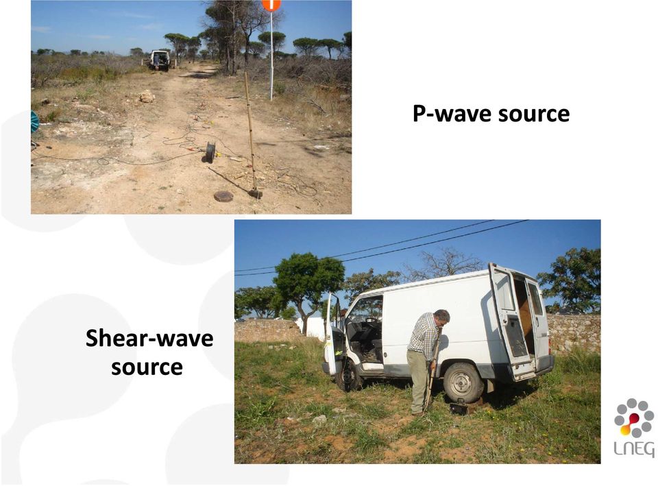
8 Refraction Data Acquisition 24 channel forpand and24 channel fors P-wave source: hammer andplate Shear wave source: wooden beam struck on both sides under the wheels ofajeep Receiver spacing of 3.5m: total profile length 84m 2 end-shots and 3 inside layout shots (first layer & reciprocal times)

9 P-wave source Shear-wave source
10 Example shot gathers P-wave Shear-wave

11 Refraction Data Interpretation Commercial software using generalized reciprocal method(palmer, 1981) and slope intercept Use detailed geological and lithological data collected at each site Use nearby well data at same elevation

12 Examples of Refraction TD curves & models

13 P and S-wave Data collected at 42 sites

14 Comparison of Refraction & Ambient Noise Data Teves-Costa et al., 2013

15 Preliminary 1: 10 6 scale VS30 Map using refraction and ambient noise Teves-Costa et al., 2013

16 Preliminary 1: 10 6 scale VS30 Map using refraction data

17 Preliminary 1: 10 6 scale VS30 Map using refraction data Santarém V. F. Xira Benavente Lisbon Setúbal

18 Preliminary Soil Classification Map

19 Soil Classification -Criteria used CLASS CRITERIA 1 CRITERIA 2 Compact deposits of Subsoil class A Subsoil class B Subsoil class C Rock or geologic formation characterized by Vs >= 800 m/s Deep deposits of medium dense sands, gravel or stiff clays with thickness from several tens to hundreds of meters (Vs >= 200 m/s at depth to Vs >= 350 m/s at 50m depth (SPT N~60) Loose cohesionless deposits with or without soft cohesive layers (Vs < 200 m/s at depths <20m (SPT N<=10) sands, gravels or overconsolidated clays, several tens of meters thick (Vs >= 400 m/s at 10m depth) Deposits with soft-to-medium stiff cohesive soils (Vs < 200 m/s at depths <20m (SPT N<=10)
 Deposits with soft-to-medium stiff cohesive soils (Vs < 200 m/s at")
20 Preliminary Soil Classification Map
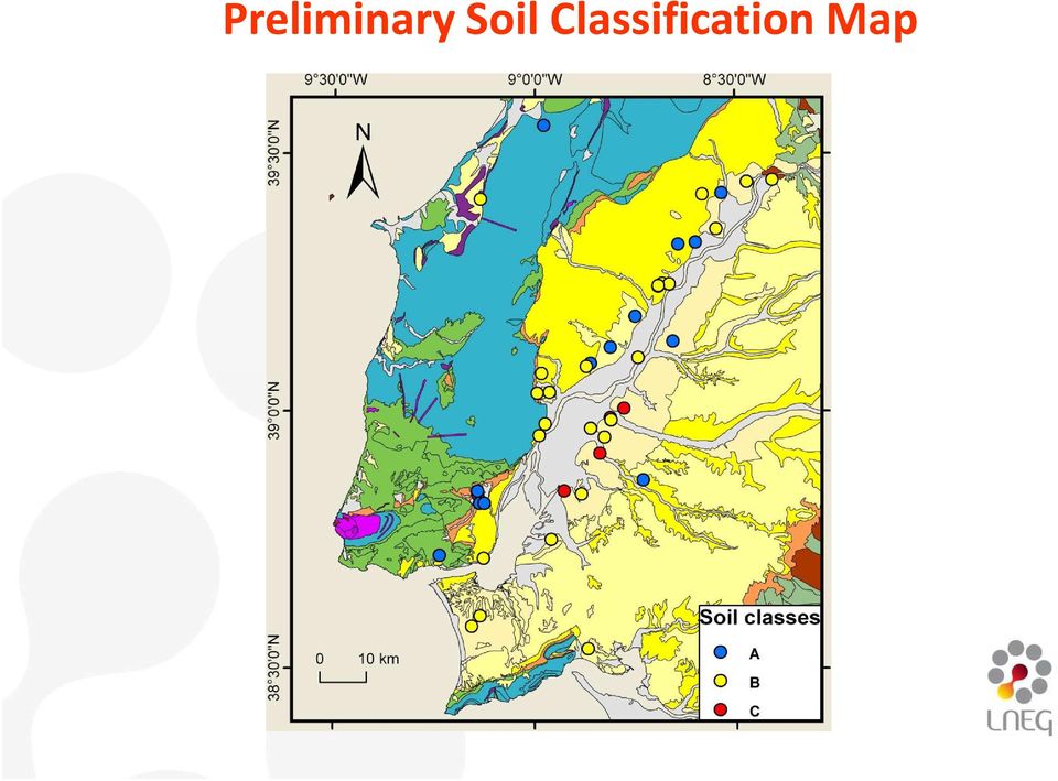
21 Preliminary Soil Classification Map Class C correspond to Holocene and Pleistocene sediments Holocene alluvium also have areas classified as B Pleistocene sediments show large variation and are also classified B or A Miocene formations can be either classified B or A
22 Conclusions At this first phase of the study the highly complex geological nature of the study area where thickness and lateral lithological changes are constant, prevents a simple geographical generalization of the velocity and soil classification data points.
23 Conclusions Preliminary VS30 and the soil classification maps presented here highlight a region of great susceptibility to earthquake shaking and where several cities are located. This region is covered by Holocene alluvium but other areas located over older geological formations also show a relatively moderate risk.
24 Acknowledgements Portuguese Foundation for Science and Technology for funding Projects: NEFITAG; SCENE; SHELT Field crew: F. Caneiras, J. Gomes Landowners: Eng Rui Paixão, Companhia das Lezírias
25 References Jimenez-Munt, I. and Negredo, A.M., 2003, Neotectonic modelling of the western part of the Africa-Eurasia plate boundary: from the Mid- Atlantic ridge to Algeria, Earth and Planetary Science Letters, 205, Palmer, Derecke, 1981, An introduction to the generalized reciprocal method of seismic refraction interpretation, Geophysics, 46, Teves-Costa, P., Rodrigues, I., Torres, R.J.G., Carvalho, J., Almeida, I.M., Borges, J.F., 2013, Vs30 estimation using ambient vibrations and seismic refraction experiments - Application to the Lower Tagus Valley (Portugal), Abstracts of the Joint Assembly IAHS-IAPSO IAPSO-IAPSEI, IAPSEI, July, Gotemburg(Sweden) (Sweden).
26 Thank You!
27
Anirudhan I.V. Geotechnical Solutions, Chennai
 Anirudhan I.V. Geotechnical Solutions, Chennai Often inadequate In some cases, excess In some cases, disoriented Bad investigation Once in a while good ones Depends on one type of investigation, often
Satish Pullammanappallil and Bill Honjas. Optim LLC, Reno, Nevada, USA. John N. Louie. J. Andrew Siemens. Siemens & Associates, Bend, Oregon, USA
 Comparative Study of the Refraction Microtremor (ReMi) Method: Using Seismic noise and standard P-wave refraction equipment for deriving 1-D S-wave profiles Satish Pullammanappallil and Bill Honjas Optim
INDIRECT METHODS SOUNDING OR PENETRATION TESTS. Dr. K. M. Kouzer, Associate Professor in Civil Engineering, GEC Kozhikode
 INDIRECT METHODS SOUNDING OR PENETRATION TESTS STANDARD PENETRATION TEST (SPT) Reference can be made to IS 2131 1981 for details on SPT. It is a field edtest to estimate e the penetration e resistance
ASSESSMENT OF SHEAR WAVE VELOCITY FROM INDIRECT INSITU TESTS
 Proceedings of Indian Geotechnical Conference IGC-2014 December 18-20, 2014, Kakinada, India ASSESSMENT OF SHEAR WAVE VELOCITY FROM INDIRECT INSITU TESTS Kant, L., M. Tech Student, Department of Earthquake
Study Guide Questions Earth Structure and Plate Tectonics
 Study Guide Questions Earth Structure and Plate Tectonics What evidence did Alfred Wegener present in 1912 to support the idea of continental drift? Why did most geologists at the time dismiss Wegener
Caltrans Geotechnical Manual
 Cone Penetration Test The cone penetration test (CPT) is an in-situ sounding that pushes an electronic penetrometer into soil and records multiple measurements continuously with depth. Compared with rotary
Abstract. Introduction
 SEISMIC REFRACTION INTERPRETATION WITH VELOCITY GRADIENT AND DEPTH OF INVESTIGATION Michael L. Rucker AMEC Earth & Environmental, Inc. Phoenix, Arizona; [email protected] Abstract Traditional interpretation
Seismic Waves Practice
 1. Base your answer to the following question on the diagram below, which shows models of two types of earthquake waves. Model A best represents the motion of earthquake waves called 1) P-waves (compressional
Module 1 : Site Exploration and Geotechnical Investigation. Lecture 5 : Geophysical Exploration [ Section 5.1 : Methods of Geophysical Exploration ]
![Module 1 : Site Exploration and Geotechnical Investigation. Lecture 5 : Geophysical Exploration [ Section 5.1 : Methods of Geophysical Exploration ]](/thumbs/40/20679662.jpg "Module 1 : Site Exploration and Geotechnical Investigation. Lecture 5 : Geophysical Exploration [ Section 5.1 : Methods of Geophysical Exploration ]") Objectives In this section you will learn the following General Overview Different methods of geophysical explorations Electrical resistivity method Seismic refraction method 5 Geophysical exploration
Objectives In this section you will learn the following General Overview Different methods of geophysical explorations Electrical resistivity method Seismic refraction method 5 Geophysical exploration
SASW, ReMi. Application. embankment
 embankment SASW, ReMi Application a... i..... "'.. a,*, Julian GarciaMayordomo a,b, Alfonso Martin c, Carbo C Laboratorio de Geotecnia, Centro de Experimentacion de Obras PUblicas (CEDEX) c/alfonso X,
TABLE OF CONTENTS PREFACE INTRODUCTION
 TABLE OF CONTENTS PREFACE The Seismic Method, 2 The Near-Surface, 4 The Scope of Engineering Seismology, 12 The Outline of This Book, 22 INTRODUCTION Chapter 1 SEISMIC WAVES 1.0 Introduction, 27 1.1 Body
CIVL451. Soil Exploration and Characterization
 CIVL451 Soil Exploration and Characterization 1 Definition The process of determining the layers of natural soil deposits that will underlie a proposed structure and their physical properties is generally
4.11 Geologic and Soil Resources
 4.11 Geologic and Soil Resources Geology and soils are evaluated as part of an environmental document because conditions in the project area can influence the type and size of a project s structure, the
Creation of Soil Liquefaction Susceptibility Maps for San Luis Obispo & Marin Counties using Geographic Information Systems.
 Creation of Soil Liquefaction Susceptibility Maps for San Luis Obispo & Marin Counties using Geographic Information Systems. Amelia M. Lowman December 2009 Dr. Lynn E. Moody Adviser Earth and Soil Sciences
Geotechnical Measurements and Explorations Prof. Nihar Ranjan Patra Department of Civil Engineering Indian Institute of Technology, Kanpur
 Geotechnical Measurements and Explorations Prof. Nihar Ranjan Patra Department of Civil Engineering Indian Institute of Technology, Kanpur Lecture No. # 13 (Refer Slide Time: 00:18) So last class, it was
A study on the Effect of Distorted Sampler Shoe on Standard Penetration Test Result in Cohesionless soil
 ISSN: 319-53 (An ISO 39: 00 Certified Organization) A study on the Effect of Distorted Sampler Shoe on Standard Penetration Test Result in Cohesionless soil Utpal Kumar Das Associate Professor, Department
Using Combination of SPT, DMT and CPT to Estimate Geotechnical Model for a Special Project in Turkey
 Using Combination of SPT, DMT and CPT to Estimate Geotechnical Model for a Special Project in Turkey Figen Orhun Onal GE, M.Sc., Site Works Manager, Zemin Etud ve Tasarım A.Ş., Istanbul, [email protected]
How To Design A Foundation
 The Islamic university - Gaza Faculty of Engineering Civil Engineering Department CHAPTER (2) SITE INVESTIGATION Instructor : Dr. Jehad Hamad Definition The process of determining the layers of natural
Applications of Integrated Vessel-based LiDAR, Multibeam Bathymetry, and Geophysical Surveys for Geohazard Assessments and Site Characterization
 Applications of Integrated Vessel-based LiDAR, Multibeam Bathymetry, and Geophysical Surveys for Geohazard Assessments and Site Characterization James Fisher Engineering Geologist Todd Mitchell Survey
The earthquake source
 Global seismology: The earthquake source Reading: Fowler p111-140 and Bolt Appendix G Earthquake location Earthquake focus: Latitude, longitude, depth Earthquake epicenter: Latitude, longitude Earthquakes
DEM modelling of the dynamic penetration process on Mars as a part of the NASA InSight Mission
 Proceedings of the 4th European Young Geotechnical Engineers Conference (EYGEC), Durham, UK Osman, A.S. & Toll, D.G. (Eds.) 05 ISBN 978-0-9933836-0 DEM modelling of the dynamic penetration process on Mars
Site Investigation. Some unsung heroes of Civil Engineering. buried right under your feet. 4. Need good knowledge of the soil conditions
 This is an attempt to create a stand alone self learning module on site investigation. Fasten your seat belts. Sit back, relax and enjoy. 1 2 Site Investigation Some unsung heroes of Civil Engineering
TECTONICS ASSESSMENT
 Tectonics Assessment / 1 TECTONICS ASSESSMENT 1. Movement along plate boundaries produces A. tides. B. fronts. C. hurricanes. D. earthquakes. 2. Which of the following is TRUE about the movement of continents?
c. Borehole Shear Test (BST): BST is performed according to the instructions published by Handy Geotechnical Instruments, Inc.
: BST is performed according to the instructions published by Handy Geotechnical Instruments, Inc.") Design Manual Chapter 6 - Geotechnical 6B - Subsurface Exploration Program 6B-2 Testing A. General Information Several testing methods can be used to measure soil engineering properties. The advantages,
Design Manual Chapter 6 - Geotechnical 6B - Subsurface Exploration Program 6B-2 Testing A. General Information Several testing methods can be used to measure soil engineering properties. The advantages,
Layers of the Earth s Interior
 Layers of the Earth s Interior 1 Focus Question How is the Earth like an ogre? 2 Objectives Explain how geologists have learned about the interior of the Earth. Describe the layers of the Earth s interior.
ENCE 4610 Foundation Analysis and Design
 This image cannot currently be displayed. ENCE 4610 Foundation Analysis and Design Shallow Foundations Total and Differential Settlement Schmertmann s Method This image cannot currently be displayed. Strength
Chittagong Hill Tract Development Facilities (CHTDF) United Nations Development Programme
 United Nations Development Programme") Chittagong Hill Tract Development Facilities (CHTDF) United Nations Development Programme Main Report Deliverable 02 Sub-Surface Properties of Soil Development in Rangamati, Bandarban and Khagrachari Municipality
Chittagong Hill Tract Development Facilities (CHTDF) United Nations Development Programme Main Report Deliverable 02 Sub-Surface Properties of Soil Development in Rangamati, Bandarban and Khagrachari Municipality
GEOPHYSICAL TESTING OF ROCK AND ITS RELATIONSHIPS TO PHYSICAL PROPERTIES FINAL REPORT
 GEOPHYSICAL TESTING OF ROCK AND ITS RELATIONSHIPS TO PHYSICAL PROPERTIES FINAL REPORT Sponsored by the Florida Department of Transportation Research Center Contract Number BDK-75-977-1 Dr. Dennis R. Hiltunen,
GEOTECHNICAL ENGINEERING FORMULAS. A handy reference for use in geotechnical analysis and design
 GEOTECHNICAL ENGINEERING FORMULAS A handy reference for use in geotechnical analysis and design TABLE OF CONTENTS Page 1. SOIL CLASSIFICATION...3 1.1 USCS: Unified Soil Classification System...3 1.1.1
Geotechnical Investigation using Standard Penetration Test (SPT) in Rangamati, Bandarban and Khagrachari Towns
 in Rangamati, Bandarban and Khagrachari Towns") 1. Introduction 1.1 Scope of Work The Asian Disaster Preparedness Centre (ADPC) is implementing the project Seismic Hazard and Vulnerability Mapping for Rangamati, Bandarban and Khagrachari Municipality.
1. Introduction 1.1 Scope of Work The Asian Disaster Preparedness Centre (ADPC) is implementing the project Seismic Hazard and Vulnerability Mapping for Rangamati, Bandarban and Khagrachari Municipality.
Regents Questions: Plate Tectonics
 Earth Science Regents Questions: Plate Tectonics Name: Date: Period: August 2013 Due Date: 17 Compared to the oceanic crust, the continental crust is (1) less dense and more basaltic (3) more dense and
ON THE INTERPRETATION OF SEISMIC CONE PENETRATION TEST (SCPT) RESULTS
 RESULTS") Studia Geotechnica et Mechanica, Vol. XXXV, No. 4, 213 DOI: 1.2478/sgem-213-33 ON THE INTERPRETATION OF SEISMIC CONE PENETRATION TEST (SCPT) RESULTS IRENA BAGIŃSKA Wrocław University of Technology, Faculty
Studia Geotechnica et Mechanica, Vol. XXXV, No. 4, 213 DOI: 1.2478/sgem-213-33 ON THE INTERPRETATION OF SEISMIC CONE PENETRATION TEST (SCPT) RESULTS IRENA BAGIŃSKA Wrocław University of Technology, Faculty
Washington 98102-3699, [email protected]
 LESSONS LEARNED FROM A STONE COLUMN TEST PROGRAM IN GLACIAL DEPOSITS Barry S. Chen 1, P.E., Member, Geo-Institute and Michael J. Bailey 2, P.E., Member, Geo-Institute ABSTRACT A stone column test program
PAPAMOA EAST URBAN DEVELOPMENT PART 1 AREA LIQUEFACTION HAZARD REVIEW Technical Report
 PAPAMOA EAST URBAN DEVELOPMENT PART 1 AREA LIQUEFACTION HAZARD REVIEW Technical Report Tauranga District Council Papamoa East Urban Development Strategy Part 1 Area Liquefaction Hazard Review Technical
New York Science Journal, 2009, 2(3), ISSN 1554-0200 http://www.sciencepub.net/newyork, [email protected]
, ISSN 1554-0200 http://www.sciencepub.net/newyork, sciencepub@gmail.com") Electrical Method in Engineering and Environmental Studies: A Case Study of Gbagada Area, Lagos State, Nigeria. Oyedele, K.F and Ojo, A.O Dept of physics (Geophysics Programme) University of Lagos, Lagos
Electrical Method in Engineering and Environmental Studies: A Case Study of Gbagada Area, Lagos State, Nigeria. Oyedele, K.F and Ojo, A.O Dept of physics (Geophysics Programme) University of Lagos, Lagos
3D stochastic modelling of litho-facies in The Netherlands
 3D stochastic modelling of litho-facies in The Netherlands Jan L. Gunnink, Jan Stafleu, Freek S. Busschers, Denise Maljers TNO Geological Survey of the Netherlands Contributions of: Armin Menkovic, Tamara
Assessment. Ian Uglow Technical Director, SLR Consulting [email protected]. 7 th October 2010
 Peat Stability Risk and Hazard Assessment Ian Uglow Technical Director, SLR Consulting [email protected] 7 th October 2010 What goes into a Peat Stability Risk Assessment? You will need: An understanding
SPECIFICATION FOR DYNAMIC CONSOLIDATION / DYNAMIC REPLACEMENT
 SPECIFICATION FOR DYNAMIC CONSOLIDATION / DYNAMIC REPLACEMENT 1.0 SOIL IMPROVEMENT 1.1 General Soil Investigation Information are provided in Part B1 annex as a guide to the Contractor for his consideration
NOTES on the CONE PENETROMETER TEST
 GE 441 Advanced Engineering Geology & Geotechnics Spring 2004 Introduction NOTES on the CONE PENETROMETER TEST The standardized cone-penetrometer test (CPT) involves pushing a 1.41-inch diameter 55 o to
Database Development for Earthquake Risk Assessment. Muhammad Murad Billah Senior GIS Coordinator
 Database Development for Earthquake Risk Assessment Muhammad Murad Billah Senior GIS Coordinator CONTENTS Base Map Development Hazard Mapping - Active Fault Study - Engineering Geological Mapping - Seismic
Settlement of Precast Culverts Under High Fills; The Influence of Construction Sequence and Structural Effects of Longitudinal Strains
 Settlement of Precast Culverts Under High Fills; The Influence of Construction Sequence and Structural Effects of Longitudinal Strains Doug Jenkins 1, Chris Lawson 2 1 Interactive Design Services, 2 Reinforced
Subsoil investigation using integrated methods at Lagos, Nigeria
 Journal of Geology and Mining Research Vol. 3(7), pp. 169-179, July 2011 Available online http://www.academicjournals.org/jgmr ISSN 2006-9766 2011 Academic Journals Full Length Research Paper Subsoil investigation
FOURTH GRADE EARTHQUAKES 1 WEEK LESSON PLANS AND ACTIVITIES
 FOURTH GRADE EARTHQUAKES 1 WEEK LESSON PLANS AND ACTIVITIES PLATE TECTONIC CYCLE OVERVIEW OF FOURTH GRADE VOLCANOES WEEK 1. PRE: Comparing different structures of volcanoes. DURING: Modeling three types
Stanford Rock Physics Laboratory - Gary Mavko. Basic Geophysical Concepts
 Basic Geophysical Concepts 14 Body wave velocities have form: velocity= V P = V S = V E = K + (4 /3)µ ρ µ ρ E ρ = λ + µ ρ where ρ density K bulk modulus = 1/compressibility µ shear modulus λ Lamé's coefficient
REFRACTION MICROTREMOR AND OPTIMIZATION METHODS AS ALTERNATIVES TO BOREHOLES FOR SITE STRENGTH AND EARTHQUAKE HAZARD ASSESSMENTS.
 REFRACTION MICROTREMOR AND OPTIMIZATION METHODS AS ALTERNATIVES TO BOREHOLES FOR SITE STRENGTH AND EARTHQUAKE HAZARD ASSESSMENTS John N. Louie and Robert E. Abbott, University of Nevada, Reno, NV Satish
Chapter 5: Earthquakes
 Chapter 5: Earthquakes 1. Experiencing an Earthquake firsthand 2. The Science of Ghost Forests and Megaearthquakes 3. Faults, Earthquakes, and Plate Tectonics 4. Seismic Waves and Earthquake Detection
An Automatic Kunzelstab Penetration Test
 An Automatic Kunzelstab Penetration Test Yongyuth Sirisriphet 1, Kitidech Santichaianant 2 1 Graduated student: Faculty of Industrial Education in and Technology. King Mongkut's University of Technology
Chapter 7 Analysis of Soil Borings for Liquefaction Resistance
 Chapter 7 Analysis of Soil Borings for Liquefaction Resistance 7.1. Introduction. This chapter addresses the analysis of subsurface soil data to determine the factor of safety against liquefaction and
GEOTECHNICAL CHARACTERIZATION OF THE ANTALYA KARSTIC ROCK MASSES
 GEOTECHNICAL CHARACTERIZATION OF THE ANTALYA KARSTIC ROCK MASSES Dr. Evrim Sopacı Consulting Engineer/Temelsu T U R K E Y The city of Antalya is built on and surrounded by one of the largest (600 km 2
hs2 Ground A non-technical guide
 hs2 Ground Investigations A non-technical guide Contents HS2 ground investigations 1 Essential Q&A 2 2 In-ground investigation techniques 9 2.1 Cable percussion borehole 10 2.2 Rotary core borehole 12
How To Prepare A Geotechnical Study For A Trunk Sewer Project In Lincoln, Nebraska
 APPENDIX B Geotechnical Engineering Report GEOTECHNICAL ENGINEERING REPORT Preliminary Geotechnical Study Upper Southeast Salt Creek Sanitary Trunk Sewer Lincoln Wastewater System Lincoln, Nebraska PREPARED
Penetrometer testing in residual soils from granitic rocks in the South of Portugal
 Penetrometer testing in residual soils from granitic rocks in the South of Portugal Isabel M. R. Duarte Department of Geosciences, University of Évora; Research Centre Industrial Minerals and Clays António
A comparative analysis of various seismic refraction interpretation techniques over granitic bedrock
 P-331 Summary A comparative analysis of various seismic refraction interpretation techniques over granitic bedrock Ankur Mundhra* 1, Om Prakash Pathak 1, Satyawrat Pamnani 1, T Sheshunarayana 2 A refraction
CHAPTER 9 LONG TERM MONITORING AT THE ROUTE 351 BRIDGE
 CHAPTER 9 LONG TERM MONITORING AT THE ROUTE 351 BRIDGE 9.1 INTRODUCTION An important reason that composite piles have not gained wide acceptance in the civil engineering practice is the lack of a long
COMPARISON OF ONE AND TWO DIMENSIONAL SITE RESPONSE ANALYSIS RESULTS FOR KUCUKCEKMECE REGION IN ISTANBUL
 4 th International Conference on Earthquake Geotechnical Engineering June 25-28, 2007 Paper No. 1351 COMPARISON OF ONE AND TWO DIMENSIONAL SITE RESPONSE ANALYSIS RESULTS FOR KUCUKCEKMECE REGION IN ISTANBUL
Chapter Overview. Bathymetry. Measuring Bathymetry. Echo Sounding Record. Measuring Bathymetry. CHAPTER 3 Marine Provinces
 Chapter Overview CHAPTER 3 Marine Provinces The study of bathymetry charts ocean depths and ocean floor topography. Echo sounding and satellites are efficient bathymetric tools. Most ocean floor features
Soil behaviour type from the CPT: an update
 Soil behaviour type from the CPT: an update P.K. Robertson Gregg Drilling & Testing Inc., Signal Hill, California, USA ABSTRACT: An initial application of CPT results is to evaluate soil type and soil
Geotechnical Investigation Reports and Foundation Recommendations - Scope for Improvement - Examples
 Geotechnical Investigation Reports and Foundation Recommendations - Scope for Improvement - Examples Prof. V.S.Raju (Formerly: Director, IIT Delhi & Professor and Dean, IIT Madras) Email: [email protected]
Improvement in physical properties for ground treated with rapid impact compaction
 International Journal of the Physical Sciences Vol. 6(22), pp. 5133-5140, 2 October 2011 Available online at http://www.academicjournals.org/ijps ISSN 1992-1950 2011 Academic Journals Full Length Research
II. Earth Science (Geology) Section (9/18/2013)
 Section (9/18/2013)") EAPS 100 Planet Earth Lecture Topics Brief Outlines II. Earth Science (Geology) Section (9/18/2013) 1. Interior of the Earth Learning objectives: Understand the structure of the Earth s interior crust,
EAPS 100 Planet Earth Lecture Topics Brief Outlines II. Earth Science (Geology) Section (9/18/2013) 1. Interior of the Earth Learning objectives: Understand the structure of the Earth s interior crust,
FINAL REPORT ON SOIL INVESTIGATION
 FINAL REPORT ON SOIL INVESTIGATION FOR PROPOSED CONSTRUCTION AT SS-6B AREA AT HPCL VISAKH REFINERY VISAKHAPATNAM ANDHRA PRADESH J.J. ASSOCIATES(VISAKHAPATNAM) AETP(P) LIMITED #11-6-3, RockDale Layout,
PALEOENVIRONMENTS OF THE LAKE BALATON AREA
 Eötvös Loránd University Department of Geophysics HUNGARY 1117 Budapest Pázmány Péter sétány 1/C Tel: +36-1-3812191 Fax: +36-1-3812192 E-mail: [email protected] PALEOENVIRONMENTS OF THE LAKE BALATON
Geotechnical Testing Methods II
 Geotechnical Testing Methods II Ajanta Sachan Assistant Professor Civil Engineering IIT Gandhinagar FIELD TESTING 2 1 Field Test (In-situ Test) When it is difficult to obtain undisturbed samples. In case
COSMOS 2012: Earthquakes in Action COSMOS 2012
 COSMOS 2012 What is SFSI and why is it important? Soil issues in Earthquakes Structures where SFSI important Retaining structures (lateral earth pressure) Foundations (spread and pile footings, bearing
Activities Earthquake Hazard Maps & Liquefaction
 Activities Earthquake Hazard Maps & Liquefaction Geology and Earth Resources Division geologists actively identify, assess, and map geologic hazards for land-use and emergency-management planning, disaster
PILE FOUNDATIONS FM 5-134
 C H A P T E R 6 PILE FOUNDATIONS Section I. GROUP BEHAVIOR 6-1. Group action. Piles are most effective when combined in groups or clusters. Combining piles in a group complicates analysis since the characteristics
Important Points: Timing: Timing Evaluation Methodology Example Immediate First announcement of building damage
 3.3. Evaluation of Building Foundation Damage Basic Terminology: Damage: Destruction, deformation, inclination and settlement of a building foundation caused by an earthquake. Damage grade: Degree of danger
1 Mobilisation and demobilisation 1 Deep boring sum 2 Cone penetration tests sum 3 Miscellenous tests sum
 Malaysian Civil Engineering Standard Method of Measurement (MyCESMM) CLASS D: SITE INVESTIGATION WORK Measurement covered under other classes: Excavation not carried out for the purpose of soil investigation
PACIFIC EARTHQUAKE ENGINEERING RESEARCH CENTER
 PACIFIC EARTHQUAKE ENGINEERING RESEARCH CENTER Guidelines for Estimation of Shear Wave Velocity Profiles Bernard R. Wair Jason T. DeJong Department of Civil and Environmental Engineering University of
Rapid Changes in Earth s Surface
 TEKS investigate rapid changes in Earth s surface such as volcanic eruptions, earthquakes, and landslides Rapid Changes in Earth s Surface Constant Changes Earth s surface is constantly changing. Wind,
Broadband seismic to support hydrocarbon exploration on the UK Continental Shelf
 Broadband seismic to support hydrocarbon exploration on the UK Continental Shelf Gregor Duval 1 1 CGGVeritas Services UK Ltd, Crompton Way, Manor Royal Estate, Crawley, RH10 9QN, UK Variable-depth streamer
Evaluation of Post-liquefaction Reconsolidation Settlement based on Standard Penetration Tests (SPT)
") RESEARCH ARTICLE OPEN ACCESS Evaluation of Post-liquefaction Reconsolidation Settlement based on Standard Penetration Tests (SPT) AlketaNdoj*,VeronikaHajdari* *Polytechnic University of Tirana, Department
RESEARCH ARTICLE OPEN ACCESS Evaluation of Post-liquefaction Reconsolidation Settlement based on Standard Penetration Tests (SPT) AlketaNdoj*,VeronikaHajdari* *Polytechnic University of Tirana, Department
Comparison of Seismic Retrofitting Methods for Existing Foundations in Seismological Active Regions
 Comparison of Seismic Retrofitting Methods for Existing Foundations in Seismological Active Regions Peyman Amini Motlagh, Ali Pak Abstract Seismic retrofitting of important structures is essential in seismological
Part 4: Seismic hazard assessment
 GIS CASE STUDY Application of GIS for earthquake hazard and risk assessment: Kathmandu, Nepal Part 4: Seismic hazard assessment Cees van Westen (E-mail : [email protected]) Siefko Slob (E-mail: [email protected])
Figure 1. Submarine cable plough
 Paramètres de calcul géotechnique. Magnan (ed.) 2002, Presses de l ENPC/LCPC, Paris PARAMETER SELECTION FOR SUBMARINE CABLE BURIAL ASSESSMENT CHOIX DES PARAMÈTRES POUR l ENFOUISSEMENT DES CÂBLES SOUS-MARINS
World Tower. Company, Inc. Classification Overview. Categories: Structure Classification Exposure Categories Topographic Effects Geological
 Manufacturing Custom Fabricated Structures since 1979 Professional In-House Design Staff Tower Delivery Service World Tower Company, Inc. Classification Overview Categories: Structure Classification Exposure
Basic Soil Erosion and Types
 Basic Soil Erosion and Types 2015 Wisconsin Lakes Convention Stacy Dehne DATCP Engineer Types of Soil Erosion Rain drop or splash erosion: Erosion preceded by the destruction of the crumb structure due
Dynamic Load Testing of Helical Piles
 Dynamic Load Testing of Helical Piles ANNUAL KANSAS CITY SPECIALTY SEMINAR 2014 JANUARY 10, 2014 Jorge Beim JWB Consulting LLC Pile Dynamics, Inc. Main Topics Brief description of the Dynamic Load Test
COMPENDIUM OF INDIAN STANDARDS ON SOIL ENGINEERING PART 2
 (PREVIEW) SP 36 (Part 2) : 1988 COMPENDIUM OF INDIAN STANDARDS ON SOIL ENGINEERING PART 2 IS 1893 : 1979 (Reaffirmed 1987) CODE OF PRACTICE FOR SUBSURFACE INVESTIGATION FOR FOUNDATIONS 1.1 This code deals
Emergency Spillways (Sediment basins)
") Emergency Spillways (Sediment basins) DRAINAGE CONTROL TECHNIQUE Low Gradient Velocity Control Short-Term Steep Gradient Channel Lining Medium-Long Term Outlet Control Soil Treatment Permanent [1] [1]
Emergency Spillways (Sediment basins) DRAINAGE CONTROL TECHNIQUE Low Gradient Velocity Control Short-Term Steep Gradient Channel Lining Medium-Long Term Outlet Control Soil Treatment Permanent [1] [1]
Table of Contents 10.1 GENERAL... 10.1-1
 Table of Contents Section Page 10.1 GENERAL... 10.1-1 10.1.1 Overview... 10.1-1 10.1.2 Role of Uncertainty in Property Interpretation... 10.1-1 10.1.3 Role of Drainage in Property Interpretation... 10.1-2
Recent ostracods from the Azores archipelago
 Joannea Geol. Paläont. 11: 132-136 (2011) Recent ostracods from the Azores archipelago Ricardo P. MEIRELES, Antonio FRIAS MARTINS & Sérgio ÁVILA The Azores is an archipelago in the Atlantic Ocean between
EARTHQUAKES. Compressional Tensional Slip-strike
 Earthquakes-page 1 EARTHQUAKES Earthquakes occur along faults, planes of weakness in the crustal rocks. Although earthquakes can occur anywhere, they are most likely along crustal plate boundaries, such
PROHITECH WP3 (Leader A. IBEN BRAHIM) A short Note on the Seismic Hazard in Israel
 A short Note on the Seismic Hazard in Israel") PROHITECH WP3 (Leader A. IBEN BRAHIM) A short Note on the Seismic Hazard in Israel Avigdor Rutenberg and Robert Levy Technion - Israel Institute of Technology, Haifa 32000, Israel Avi Shapira International
PROHITECH WP3 (Leader A. IBEN BRAHIM) A short Note on the Seismic Hazard in Israel Avigdor Rutenberg and Robert Levy Technion - Israel Institute of Technology, Haifa 32000, Israel Avi Shapira International
GEOTECHNICAL ENGINEERING II. Subject Code : 06CV64 Internal Assessment Marks : 25 PART A UNIT 1
 GEOTECHNICAL ENGINEERING II Subject Code : 06CV64 Internal Assessment Marks : 25 PART A UNIT 1 1. SUBSURFACE EXPLORATION 1.1 Importance, Exploration Program 1.2 Methods of exploration, Boring, Sounding
The correct answers are given below. Some talking points have been added for the teachers use.
 Natural Resources Canada 2011: Lesson Plan Grades 11 and 12 Landslide activity 5b: Landslides in Canada quiz Description: This is an independent study activity for grades 11 and 12. Students will read
Unit 4 Lesson 6 Measuring Earthquake Waves. Copyright Houghton Mifflin Harcourt Publishing Company
 Shake, Rattle, and Roll What happens during an earthquake? As plates of the lithosphere move, the stress on rocks at or near the edges of the plates increases. This stress causes faults to form. A fault
Groundwater exploration WATEX applications with Ground Penetrating Radars. Dr.Saud Amer USGS Dr.Alain Gachet Radar Technologies France
 Groundwater exploration WATEX applications with Ground Penetrating Radars Dr.Saud Amer USGS Dr.Alain Gachet Radar Technologies France GPR is a technology that allows rapid and non destructive collection
Optimised Design for Soil Nailed Walls 1
 Optimised Design for Soil Nailed Walls 1 J A R Ortigao 1 and E M Palmeira 2 1 Federal University of Rio de Janeiro, Rio de Janeiro, Brazil 2 University of Brasília, Brasília, Brazil INTRODUCTION The first
FOUNDATION DESIGN. Instructional Materials Complementing FEMA 451, Design Examples
 FOUNDATION DESIGN Proportioning elements for: Transfer of seismic forces Strength and stiffness Shallow and deep foundations Elastic and plastic analysis Foundation Design 14-1 Load Path and Transfer to
Mapping the Tyrrhenian and Adriatic Mohos across the northern and central Apennine chain through teleseismic receiver functions
 Mapping the Tyrrhenian and Adriatic Mohos across the northern and central Apennine chain through teleseismic receiver functions Giuliana Mele Istituto Nazionale di Geofisica e Vulcanologia - Roma, Italy
Numerical Simulation of CPT Tip Resistance in Layered Soil
 Numerical Simulation of CPT Tip Resistance in Layered Soil M.M. Ahmadi, Assistant Professor, [email protected] Dept. of Civil Engineering, Sharif University of Technology, Tehran, Iran Abstract The paper
Marine broadband seismic: Is the earth response helping the resolution revolution? N. Woodburn*, A. Hardwick, and R. Herring, TGS
 Marine broadband seismic: Is the earth response helping the resolution revolution? N. Woodburn*, A. Hardwick, and R. Herring, TGS Summary Broadband seismic aims to provide a greater richness of both (a),
EARTHQUAKE BASICS. LIQUEFACTION What it is and what to do about it
 EARTHQUAKE BASICS BRIEF NO. 1 LIQUEFACTION EARTHQUAKE BASICS LIQUEFACTION What it is and what to do about it Purpose This pamphlet, the first in a series, has been written by members of the Earthquake
EARTHWORKS COMPLETION REPORT ELLEN STIRLING PARADE, ELLENBROOK. Ellenbrook, W.A. Georgiou Group Pty Ltd
 EARTHWORKS COMPLETION REPORT ELLEN STIRLING PARADE, ELLENBROOK Ellenbrook, W.A. Georgiou Group Pty Ltd GEOTPERT08050AZ-AH 27 March 2013 EARTHWORKS COMPLETION REPORT ELLEN STIRLING PARADE, ELLENBROOK Ellenbrook,
7.2.4 Seismic velocity, attenuation and rock properties
 7.2.4 Seismic velocity, attenuation and rock properties Rock properties that affect seismic velocity Porosity Lithification Pressure Fluid saturation Velocity in unconsolidated near surface soils (the
Brief Review of Global Earth Velocity Structures and Seismology
 Class 1: Introduction to Seismic Wave Propagation Wed, Sept 9, 2009 Today we are going to discuss about the following issues: Brief review of global Earth structures and seismology Near-surface geology
GLG 112: Geologic Disasters Syllabus 2012
 Instructor Name School of Earth Sciences and Environmental Sustainability, Geology Program Office: Bldg X, Room X; Phone: 523- XXXX; Email: instructor e-mail Class Time (Blg 12, Rm 103) Instructor Office