Wintry weather: improved nowcasting through data fusion
|
|
|
- Gordon Leonard
- 8 years ago
- Views:
Transcription
1 Wintry weather: improved nowcasting through data fusion Arnold Tafferner, Felix Keis DLR Institut für Physik der Atmosphäre (IPA) Wetter&Fliegen Final Colloquium, MAC MUC, 15 March

2 Outline The problem Available observation MUC Available forecast data Winter weather objects Nowcasting concept 2

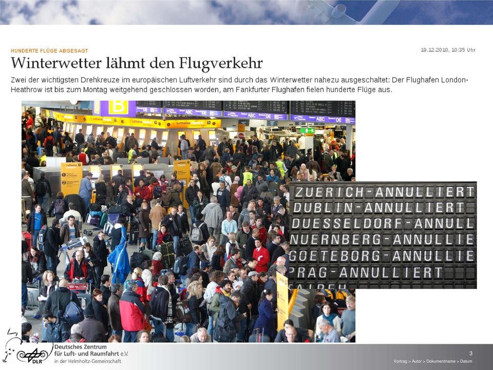
3 3
4 Snow clearing and de-icing procedures 4

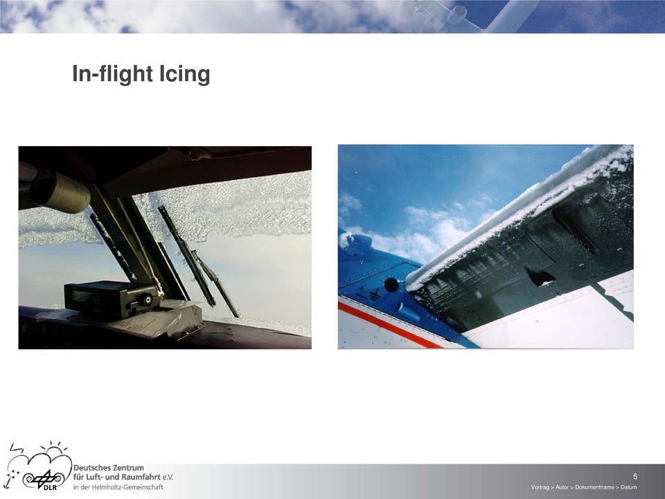
5 In-flight Icing 5
6 6
7 7

8 8

9 Main objectives within project weather and flying Improve the winter weather nowcasting for Munich Airport: Icing conditions at the surface Aircraft icing on approach, take-off and at the ground Onset, duration, amount and type of precipitation Combine observation and forecast data to determine and nowcast wintry weather conditions 9

10 The meteorological problem Forecasts of snow fall are available days in advance However: Snow events often occur in the form of showers, the precipitation amount they bring and their timing is difficult to predict Small changes in temperature, humidity and cloud properties (aerosol, turbulence), especially aorund 0⁰C, can turn a harmless cloud into a hazardous cloud with supercooled droplets and freezing precipitation Nowcasting these subtle changes in cloud parameters and their effect on precipitation are difficult to predict Cloud composition, i.e. cloud droplet size distribution, ice cristal concentration, precipitation particles (snow, rain, graupel) and turbulent wind are not directly measured However, remote sensing observation instruments in combination with standard observations, high resolution forecasts and data fusion concepts offer the possibilty to better handle the situation 10

11 Schematic illustration of available data at Munich airport Winter Weather Object COSMOMUC T,RH profiles SYNOP METAR Micro Rain Radar Parsivel Disdrometer Glatteis- Frühwarnsystem TMA volume boundary AMDAR SWIS POLDIRAD COSMOMUC 11

12 Analysis of Winter Weather Conditions Approach: Development of an advanced version of ADWICE in order to combine (fuzzy logic) surface observations (SYNOP, GFS) with meteo profiles (AMDAR, COSMOMUC), and remote sensing measurements (POLDIRAD, MRR, PARSIVEL) in order to determine: Melting/freezing conditions (de-icing procedures) Aircraft icing on approach and take-off Precip. type (snow, rain, freezing rain) and amount (light, moderate, severe) 2500 AGL MRR rain snow Meteo profile SLD 0 C AMDAR SYNOP METAR + COSMOMUC Automatic sensors F U S I O N Ht H2 H1 Hb MUC 0 m MUC 12
 and amount (light, moderate, severe) 2500 AGL MRR rain snow Meteo profile SLD 0 C AMDAR SYNOP METAR + COSMOMUC")
13 Advanced Diagnosis and Warning system for aircraft ICing Environments ADWICE has been developed since 1998 in a joint co-operation between DLR, DWD and IMuK Hannover is based on a former NCAR-RAP algorithm (adopted for the European area, meanwhile considerably extended/changed) merges forecast model data with hourly observation and radar data 1st version has been run pre-operationally at DWD since nd version output used operationally References Tafferner et al: ADWICE The Advanced Diagnosis and Warning system for aircraft ICing Environments; Wea. & Forec. Vol.18, No.2, April 2003 Leifeld, 2003, Weiterentwicklung des Nowcastingsystems ADWICE zur Erkennung vereisungsgefährdeter Lufträume, DWD Internal report / PhD thesis University of Hannover Rosczyk, 2004, Evaluation of the Advanced Diagnosis and Warning system for aircraft ICing Environments (ADWICE) Methodical aspects, Final thesis, University of Hannover 13

14 The advantages of ADWICE ADWICE runs automatic forecasts and analyses of icing environments for aviation is laid out to detect all significant environments (SLD, moderate & severe icing) provides this icing information to forecasters, pilots Advantages for forecasters: checks all the data more carefully and faster than forecasters are able to do it filters out the significant information of all the data reduces the possibility of overlooking significant icing hazards Forecasters/meteorologists experiences and know how has been used to develop prognostic and diagnostic icing algorithms for ADWICE 14

15 ADWICE Prognostic Icing Product - PIP model data (COSMO-EU): temperature specific humidity parameterization of moist convection Identification of icing scenarios freezing convective stratiform general ADWICE PIP FL UTC 3D - Prognostic Icing Product (PIP) 15

16 Icing scenario freezing model sounding 0 C Search for precipitable cloud beneath cirrus layer (-50 C T) relative humidity (RH) 80%, z 3000m Check possible evaporation beneath precipitable cloud evaporation of precip. if RH < 80% and z > 3000m Melting layer with T > 0 C SLD Supercooled layer with SLD / FZRA T 0 C SEVERE ICING Layer above freezing (T > 0 C), no inflight icing 16

17 Icing scenario stratiform model sounding check if there is a precipitable cloud beneath cirrus layer: (-50 C T) RH 80%, z 3000m 0 C If precipitable cloud above than check the evaporation layer: evaporation of precipitation if RH < 80% and z > 3000m SLD Search for cloud top with significant gradient of humidity: RH 2.5 % / 100m, -12 C CTT 0 C Stratiform layer with SLD / FZDZ: -12 C T 0 C, RH 85% Layer above freezing (T > 0 C), no inflight icing 17
,")
18 Icing scenarios convective and general convective SLD in large towering cumulus (TCU) parameterization of moist convection Z 3000m & -40 C T 0 C general Clouds containing supercooled liquid water temperature -20 C T 0 C relative humidity varies linear with temperature: rh x%, 63% x 82% 18

19 Use of local data at MUC: AMDAR data (+) No icing derived from AMDAR Icing scenario stratiform derived from model forecast Correction of ADWICE scenario by use of AMDAR 19

20 Nowcasting: Data Availability 1 hrly background VERA, SYNOP, COSMO-DE 1/2 hrly METAR 10 min POLDIRAD, MRR, PARSIVEL, AMDAR, GFS, COSMOMUC Use these data in fuzzy logic procedure with frequent update 2nd talk 20 Vortrag > Autor > Dokumentname > Datu

21 Nowcasting: COSMOMUC Output 1- hour assimilation/forecast cycle enables: Frequent output (10 min) Assimilation of most recent observations from Radar, SYNOP, AMDAR, SODAR/RASS Optimized lower boundary data: landuse, soil Small domain - fast execution time-lagged ensemble precip type and amount hydrometeor mixing ratio fields in vertical sections along and across glide path profiles ADWICE icing conditions 21
22 COSMOMUC (t a ) (t a +1h) (t a +2h) (t a ) local data real time local data COSMO-EU Initial & boundary Time DATA ASSIMILATION forecast O U T P U T DATA ASSIMILATION DATA ASSIMILATION forecast Boundary data from COSMO-EU Boundary plus assimilated data; Initial data: Restart or NewStart DATA ASSIMILATION forecast Nudging of local data 22
23 23
24 ADWICE Diagnostic Icing Algorithm Example 20. Jan UTC - FL250 24
25 Integration of additional data at stations around MUC Radar COSMO AMDAR Classification of hydrometeors GFS POLDIRAD SWIS 25
26 Nowcasting Concept Analysis Use all available local data with high refresh rates Apply fuzzy logic (extended ADWICE) Trend Take into account changes of local measurements (2nd talk) Use forecast data of COSMOMUC for trend estimates Take into account diagnostics at surrounding stations: advection of upstream weather Nowcast Combine analysis with trend to estimate conditions up to 2 hours 26
27 Summary Local Met data at and around MUC together with remote sensing from polarimetric radar (POLDIRAD) have the potential to improve existing ADWICE diagnostics: hydrometeor type, drop size, precipitation rate, icing scenario, icing intensity First results indicate that ADWICE operated with COSMO-DE instead with COSMO-EU reduces overforecasting The time-lagged ensemble COSMOMUC is expected to provide more accurate forecasts of precipitation, especially as regards to timing of events Nowcasting concept has been developed: combination of trends of local observations with COSMOMUC forecasts and advection of upstream observations first results in 2nd talk 27
2.4 Nowcasting Winter Weather at Munich Airport (Tafferner, Keis) Final Report
 Final Report") 2.4 Nowcasting Winter Weather at Munich Airport (Tafferner, Keis) Final Report 2.4 Nowcasting Winter Weather at Munich Airport Arnold Tafferner, Felix Keis Institute of Atmospheric Physics The WxFUSION
2.4 Nowcasting Winter Weather at Munich Airport (Tafferner, Keis) Final Report 2.4 Nowcasting Winter Weather at Munich Airport Arnold Tafferner, Felix Keis Institute of Atmospheric Physics The WxFUSION
WxFUSION. A. Tafferner. Folie 1. iport Meeting 13.10.2010 @ DLR OP
 WxFUSION A. Tafferner iport Meeting 13.10.2010 @ DLR OP Folie 1 Upper Danube Catchment MUC DLR Andechs Munich Vienna Folie 2 Local and propagating thunderstorms in the Upper Danube Catchment B. Barternschlager,
1861-35. European Conference on Severe Storms (ECSS 2007) 10-14 September 2007
 10-14 September 2007") 1861-35 European Conference on Severe Storms (ECSS 2007) 10-14 September 2007 Development of an operational thunderstorm forecast system for air traffic FORSTER Caroline Institut fuer Physik der Atmosphere,
1861-35 European Conference on Severe Storms (ECSS 2007) 10-14 September 2007 Development of an operational thunderstorm forecast system for air traffic FORSTER Caroline Institut fuer Physik der Atmosphere,
Glaciogenic Cloud Seeding to Increase Orographic Precipitation Bruce A. Boe bboe@weathermod.com Director of Meteorology
 Glaciogenic Cloud Seeding to Increase Orographic Precipitation Bruce A. Boe bboe@weathermod.com Director of Meteorology Weather Modification, Inc. Fargo, North Dakota, USA www.weathermodification.com Content
Information on thunderstorm initiation, nowcast, and forecast for aviation safety and efficiency
 Information on thunderstorm initiation, nowcast, and forecast for aviation safety and efficiency by Dennis Stich, C. Forster, A. Tafferner, M. Köhler, I. Sölch, and T. Gerz 1 st ECATS Conference (on Technical
Nowcasting: analysis and up to 6 hours forecast
 Nowcasting: analysis and up to 6 hours forecast Very high resoultion in time and space Better than NWP Rapid update Application oriented NWP problems for 0 6 forecast: Incomplete physics Resolution space
In a majority of ice-crystal icing engine events, convective weather occurs in a very warm, moist, tropical-like environment. aero quarterly qtr_01 10
 In a majority of ice-crystal icing engine events, convective weather occurs in a very warm, moist, tropical-like environment. 22 avoiding convective Weather linked to Ice-crystal Icing engine events understanding
Fog and low cloud ceilings in the northeastern US: climatology and dedicated field study
 Fog and low cloud ceilings in the northeastern US: climatology and dedicated field study Robert Tardif National Center for Atmospheric Research Research Applications Laboratory 1 Overview of project Objectives:
Introduction to the forecasting world Jukka Julkunen FMI, Aviation and military WS
 Boundary layer challenges for aviation forecaster Introduction to the forecasting world Jukka Julkunen FMI, Aviation and military WS 3.12.2012 Forecast for general public We can live with it - BUT Not
How To Understand And Understand The Physics Of Clouds And Precipitation
 Deutscher Wetterdienst Research and Development Physical Parameterizations: Cloud Microphysics and Subgrid-Scale Cloudiness Axel Seifert Deutscher Wetterdienst, Offenbach Deutscher Wetterdienst Research
Cloud seeding. Frequently Asked Questions. What are clouds and how are they formed? How do we know cloud seeding works in Tasmania?
 What are clouds and how are they formed? Clouds are composed of water droplets and sometimes ice crystals. Clouds form when air that is rich in moisture near the Earth s surface rises higher into the atmosphere,
CENTRAL TEXAS COLLEGE SYLLABUS FOR AIRP 1307 AVIATION METEOROLOGY Semester Hours Credit: 3
 CENTRAL TEXAS COLLEGE SYLLABUS FOR AIRP 1307 AVIATION METEOROLOGY Semester Hours Credit: 3 INSTRUCTOR: OFFICE HOURS: I. INTRODUCTION A. The purpose of this course is to study Meteorology as it applies
Implementation Guidance of Aeronautical Meteorological Forecaster Competency Standards
 Implementation Guidance of Aeronautical Meteorological Forecaster Competency Standards The following guidance is supplementary to the AMP competency Standards endorsed by Cg-16 in Geneva in May 2011. Implicit
High-resolution Regional Reanalyses for Europe and Germany
 High-resolution Regional Reanalyses for Europe and Germany Christian Ohlwein 1,2, Jan Keller 1,4, Petra Friederichs 2, Andreas Hense 2, Susanne Crewell 3, Sabrina Bentzien 1,2, Christoph Bollmeyer 1,2,
If wispy, no significant icing or turbulence. If dense or in bands turbulence is likely. Nil icing risk. Cirrocumulus (CC)
") Cirrus (CI) Detached clouds in the form of delicate white filaments or white patches or narrow bands. These clouds have a fibrous or hair like appearance, or a silky sheen or both. with frontal lifting
Cirrus (CI) Detached clouds in the form of delicate white filaments or white patches or narrow bands. These clouds have a fibrous or hair like appearance, or a silky sheen or both. with frontal lifting
Roelof Bruintjes, Sarah Tessendorf, Jim Wilson, Rita Roberts, Courtney Weeks and Duncan Axisa WMA Annual meeting 26 April 2012
 Aerosol affects on the microphysics of precipitation development in tropical and sub-tropical convective clouds using dual-polarization radar and airborne measurements. Roelof Bruintjes, Sarah Tessendorf,
The horizontal diffusion issue in CRM simulations of moist convection
 The horizontal diffusion issue in CRM simulations of moist convection Wolfgang Langhans Institute for Atmospheric and Climate Science, ETH Zurich June 9, 2009 Wolfgang Langhans Group retreat/bergell June
MM5/COSMO-DE Model Inter-Comparison and Model Validation
 MM5/COSMO-DE Model Inter-Comparison and Model Validation Klaus Dengler and Christian Keil DLR, Institute of Atmospheric Physics Assessment of forecast quality using observations of the FRA airport campaign
Cloud/Hydrometeor Initialization in the 20-km RUC Using GOES Data
 WORLD METEOROLOGICAL ORGANIZATION COMMISSION FOR BASIC SYSTEMS OPEN PROGRAMMME AREA GROUP ON INTEGRATED OBSERVING SYSTEMS EXPERT TEAM ON OBSERVATIONAL DATA REQUIREMENTS AND REDESIGN OF THE GLOBAL OBSERVING
A model to observation approach to evaluating cloud microphysical parameterisations using polarimetric radar
 A model to observation approach to evaluating cloud microphysical parameterisations using polarimetric radar Monika Pfeifer G. Craig, M. Hagen, C. Keil Polarisation Doppler Radar POLDIRAD Rain Graupel
TOPIC: CLOUD CLASSIFICATION
 INDIAN INSTITUTE OF TECHNOLOGY, DELHI DEPARTMENT OF ATMOSPHERIC SCIENCE ASL720: Satellite Meteorology and Remote Sensing TERM PAPER TOPIC: CLOUD CLASSIFICATION Group Members: Anil Kumar (2010ME10649) Mayank
WEATHER THEORY Temperature, Pressure And Moisture
 WEATHER THEORY Temperature, Pressure And Moisture Air Masses And Fronts Weather Theory- Page 77 Every physical process of weather is a result of a heat exchange. The standard sea level temperature is 59
Investigations on COSMO 2.8Km precipitation forecast
 Investigations on COSMO 2.8Km precipitation forecast Federico Grazzini, ARPA-SIMC Emilia-Romagna Coordinator of physical aspects group of COSMO Outline Brief description of the COSMO-HR operational suites
Project Title: Quantifying Uncertainties of High-Resolution WRF Modeling on Downslope Wind Forecasts in the Las Vegas Valley
 University: Florida Institute of Technology Name of University Researcher Preparing Report: Sen Chiao NWS Office: Las Vegas Name of NWS Researcher Preparing Report: Stanley Czyzyk Type of Project (Partners
Clouds. A simple scientific explanation for the weather-curious. By Kira R. Erickson
 Clouds A simple scientific explanation for the weather-curious By Kira R. Erickson Table of Contents 1 3 4 INTRO 2 Page 3 How Clouds Are Formed Types of Clouds Clouds and Weather More Information Page
Various Implementations of a Statistical Cloud Scheme in COSMO model
 2 Working Group on Physical Aspects 61 Various Implementations of a Statistical Cloud Scheme in COSMO model Euripides Avgoustoglou Hellenic National Meteorological Service, El. Venizelou 14, Hellinikon,
Meteorological Forecasting of DNI, clouds and aerosols
 Meteorological Forecasting of DNI, clouds and aerosols DNICast 1st End-User Workshop, Madrid, 2014-05-07 Heiner Körnich (SMHI), Jan Remund (Meteotest), Marion Schroedter-Homscheidt (DLR) Overview What
Requirements of Aircraft Observations data and Data Management Framework for Services and Other Data Users. (Submitted bymichael Berechree)
") WORLD METEOROLOGICAL ORGANIZATION WMO AMDAR PANEL WORKSHOP ON AIRCRAFT OBSERVING SYSTEM DATA MANAGEMENT Workshop on Aircraft Observing System Data Management/Doc.3.2 (31.V.2012) (GENEVA, SWITZERLAND, 5
WORLD METEOROLOGICAL ORGANIZATION WMO AMDAR PANEL WORKSHOP ON AIRCRAFT OBSERVING SYSTEM DATA MANAGEMENT Workshop on Aircraft Observing System Data Management/Doc.3.2 (31.V.2012) (GENEVA, SWITZERLAND, 5
Cloud Profiling at the Lindenberg Observatory
 Cloud Profiling at the Lindenberg Observatory Ulrich Görsdorf DWD, Cloud Profiling with a Ka-Band radar at the Lindenberg Observatory Ulrich Görsdorf DWD, MIRA 35.5 GHz (8 mm) Radar (Ka-Band) Coherent
Cloud-Resolving Simulations of Convection during DYNAMO
 Cloud-Resolving Simulations of Convection during DYNAMO Matthew A. Janiga and Chidong Zhang University of Miami, RSMAS 2013 Fall ASR Workshop Outline Overview of observations. Methodology. Simulation results.
MICROPHYSICS COMPLEXITY EFFECTS ON STORM EVOLUTION AND ELECTRIFICATION
 MICROPHYSICS COMPLEXITY EFFECTS ON STORM EVOLUTION AND ELECTRIFICATION Blake J. Allen National Weather Center Research Experience For Undergraduates, Norman, Oklahoma and Pittsburg State University, Pittsburg,
Clouds for pilots. Ed Williams. http://williams.best.vwh.net/
 Clouds for pilots Ed Williams http://williams.best.vwh.net/ Clouds are important to pilots! Many of our weather problems are associated with clouds: Fog Thunderstorms Cloud In flight icing Cloud physics
Towards an NWP-testbed
 Towards an NWP-testbed Ewan O Connor and Robin Hogan University of Reading, UK Overview Cloud schemes in NWP models are basically the same as in climate models, but easier to evaluate using ARM because:
ASR CRM Intercomparison Study on Deep Convective Clouds and Aerosol Impacts
 ASR CRM Intercomparison Study on Deep Convective Clouds and Aerosol Impacts J. FAN, B. HAN, PNNL H. MORRISON, A. VARBLE, S. COLLIS, X. DONG, S. GIANGRANDE, M. JENSEN, P. KOLLIAS, E. MANSELL, T. TOTO April
IMPACT OF SAINT LOUIS UNIVERSITY-AMERENUE QUANTUM WEATHER PROJECT MESONET DATA ON WRF-ARW FORECASTS
 IMPACT OF SAINT LOUIS UNIVERSITY-AMERENUE QUANTUM WEATHER PROJECT MESONET DATA ON WRF-ARW FORECASTS M. J. Mueller, R. W. Pasken, W. Dannevik, T. P. Eichler Saint Louis University Department of Earth and
GCMs with Implicit and Explicit cloudrain processes for simulation of extreme precipitation frequency
 GCMs with Implicit and Explicit cloudrain processes for simulation of extreme precipitation frequency In Sik Kang Seoul National University Young Min Yang (UH) and Wei Kuo Tao (GSFC) Content 1. Conventional
Long-term Observations of the Convective Boundary Layer (CBL) and Shallow cumulus Clouds using Cloud Radar at the SGP ARM Climate Research Facility
 and Shallow cumulus Clouds using Cloud Radar at the SGP ARM Climate Research Facility") Long-term Observations of the Convective Boundary Layer (CBL) and Shallow cumulus Clouds using Cloud Radar at the SGP ARM Climate Research Facility Arunchandra S. Chandra Pavlos Kollias Department of Atmospheric
Long-term Observations of the Convective Boundary Layer (CBL) and Shallow cumulus Clouds using Cloud Radar at the SGP ARM Climate Research Facility Arunchandra S. Chandra Pavlos Kollias Department of Atmospheric
Lecture 7a: Cloud Development and Forms
 Lecture 7a: Cloud Development and Forms Why Clouds Form Cloud Types (from The Blue Planet ) Why Clouds Form? Clouds form when air rises and becomes saturated in response to adiabatic cooling. Four Ways
Not all clouds are easily classified! Cloud Classification schemes. Clouds by level 9/23/15
 Cloud Classification schemes 1) classified by where they occur (for example: high, middle, low) 2) classified by amount of water content and vertical extent (thick, thin, shallow, deep) 3) classified by
Chapter 8, Part 1. How do droplets grow larger? Cloud Droplets in Equilibrium. Precipitation Processes
 Chapter 8, Part 1 Precipitation Processes How do droplets grow larger? Cloud contain water droplets, but a cloudy sky does not always mean rain. Cloud Droplets in Equilibrium In equilibrium water molecules
Wind turbine blade heating
 Wind turbine blade heating Can it pay even more? René Cattin Icing in Switzerland Wind map of Switzerland Currently installed: 40 MW Potential: 400 600 MW (maybe more?) 6-7.5 m/s Icing Reserach Project
Proposals of Summer Placement Programme 2015
 Proposals of Summer Placement Programme 2015 Division Project Title Job description Subject and year of study required A2 Impact of dual-polarization Doppler radar data on Mathematics or short-term related
How To Model The Weather
 Convection Resolving Model (CRM) MOLOCH 1-Breve descrizione del CRM sviluppato all ISAC-CNR 2-Ipotesi alla base della parametrizzazione dei processi microfisici Objectives Develop a tool for very high
Formation & Classification
 CLOUDS Formation & Classification DR. K. K. CHANDRA Department of forestry, Wildlife & Environmental Sciences, GGV, Bilaspur What is Cloud It is mass of tiny water droplets or ice crystals or both of size
Aircraft Icing. FAR 25, Appendix C charts. Prof. Dr. Serkan ÖZGEN. Dept. Aerospace Engineering, METU Spring 2014
 Aircraft Icing FAR 25, Appendix C charts Prof. Dr. Serkan ÖZGEN Dept. Aerospace Engineering, METU Spring 2014 Outline FAR 25 and FAR 29 Appendix C charts Using FAR 25 Appendix C charts Liquid water content
Frank and Charles Cohen Department of Meteorology The Pennsylvania State University University Park, PA, 16801 -U.S.A.
 376 THE SIMULATION OF TROPICAL CONVECTIVE SYSTEMS William M. Frank and Charles Cohen Department of Meteorology The Pennsylvania State University University Park, PA, 16801 -U.S.A. ABSTRACT IN NUMERICAL
Fog and Cloud Development. Bows and Flows of Angel Hair
 Fog and Cloud Development Bows and Flows of Angel Hair 1 Ch. 5: Condensation Achieving Saturation Evaporation Cooling of Air Adiabatic and Diabatic Processes Lapse Rates Condensation Condensation Nuclei
Clouds, Fog, & Precipitation
 firecatching.blogspot.com Kids.brittanica.com Clouds and fog are physically the same just location is different Fog is considered a stratus cloud at or near the surface What does one see when looking at
UNIT 6a TEST REVIEW. 1. A weather instrument is shown below.
 UNIT 6a TEST REVIEW 1. A weather instrument is shown below. Which weather variable is measured by this instrument? 1) wind speed 3) cloud cover 2) precipitation 4) air pressure 2. Which weather station
Weather Radar Basics
 Weather Radar Basics RADAR: Radio Detection And Ranging Developed during World War II as a method to detect the presence of ships and aircraft (the military considered weather targets as noise) Since WW
RE: James vs. ABC Company Greentown, NJ D/A: February 20, 2011
 PO Box 7100 Hackettstown, NJ 07840 Phone: 1 800 427 3456 Fax: 908-850-8664 http://www.weatherworksinc.com June 16, 2012 Attn: John Doe Law Offices of John Doe 123 Fourth Street Smithtown, NJ 04506 RE:
Highly Scalable Dynamic Load Balancing in the Atmospheric Modeling System COSMO-SPECS+FD4
 Center for Information Services and High Performance Computing (ZIH) Highly Scalable Dynamic Load Balancing in the Atmospheric Modeling System COSMO-SPECS+FD4 PARA 2010, June 9, Reykjavík, Iceland Matthias
Traffic Management Systems with Air Quality Monitoring Feedback. Phil Govier City & County of Swansea
 Traffic Management Systems with Air Quality Monitoring Feedback Phil Govier City & County of Swansea The Swansea Project - what are we trying to achieve? Develop a working traffic emissions forecast model
Assimilation of radar derived rain rates into the convective scale model COSMO-DE at DWD
 Q. J. R. Meteorol. Soc. (9999), 999, pp. 1 999 doi: 10.1256/qj.99.9 Assimilation of radar derived rain rates into the convective scale model COSMO-DE at DWD By K. STEPHAN, S. KLINK and C. SCHRAFF Deutscher
Mode-S Enhanced Surveillance derived observations from multiple Air Traffic Control Radars and the impact in hourly HIRLAM
 Mode-S Enhanced Surveillance derived observations from multiple Air Traffic Control Radars and the impact in hourly HIRLAM 1 Introduction Upper air wind is one of the most important parameters to obtain
1. a. Surface Forecast Charts (USA and Ontario and Quebec) http://www.rap.ucar.edu/weather/
 http://www.rap.ucar.edu/weather/") COMPUTER ASSISTED METEOROLOGY Frank Pennauer This contribution gives the available computer data sources, how to access them and use this data for predicting Soaring weather conditions will be discussed
COMPUTER ASSISTED METEOROLOGY Frank Pennauer This contribution gives the available computer data sources, how to access them and use this data for predicting Soaring weather conditions will be discussed
Common Cloud Names, Shapes, and Altitudes:
 Common Cloud Names, Shapes, and Altitudes: Low Clouds Middle Clouds High Clouds Genus Cumulus Cumulonimbus (extend through all 3 levels) Stratus Stratocumulus Altocumulus Altostratus Nimbostratus (extend
Water, Phase Changes, Clouds
 TUESDAY: air & water & clouds Water, Phase Changes, Clouds How can freezing make something warmer? 'warm air can hold more water' why? How do clouds form? The (extraordinary) properties of Water Physical
Assessing the performance of a prognostic and a diagnostic cloud scheme using single column model simulations of TWP ICE
 Quarterly Journal of the Royal Meteorological Society Q. J. R. Meteorol. Soc. 138: 734 754, April 2012 A Assessing the performance of a prognostic and a diagnostic cloud scheme using single column model
Hong Kong Observatory Summer Placement Programme 2015
 Annex I Hong Kong Observatory Summer Placement Programme 2015 Training Programme : An Observatory mentor with relevant expertise will supervise the students. Training Period : 8 weeks, starting from 8
LOUISIANA TECH UNIVERSITY DEPARTMENT OF PROFESSIONAL AVIATION PART 141 FLIGHT SCHOOL
 LOUISIANA TECH UNIVERSITY DEPARTMENT OF PROFESSIONAL AVIATION PART 141 FLIGHT SCHOOL INSTRUMENT RATING CERTIFICATION COURSE GROUND AND FLIGHT TRAINING MANUAL October 15, 2008 LIST OF EFFECTIVE PAGES October
DWDs new radar network and post-processing algorithm chain
 DWDs new radar network and post-processing algorithm chain Kathleen Helmert 1, Patrick Tracksdorf 1, Jörg Steinert 1, Manuel Werner 1, Michael Frech 2, Nils Rathmann 1, Thomas Hengstebeck 1, Michael Mott
Very High Resolution Arctic System Reanalysis for 2000-2011
 Very High Resolution Arctic System Reanalysis for 2000-2011 David H. Bromwich, Lesheng Bai,, Keith Hines, and Sheng-Hung Wang Polar Meteorology Group, Byrd Polar Research Center The Ohio State University
"Attività di modellistica numerica previsionale meteorologica al Servizio IdroMeteoClima di ARPA Emilia-Romagna"
 "Attività di modellistica numerica previsionale meteorologica al Servizio IdroMeteoClima di ARPA Emilia-Romagna" Author: Tiziana Paccagnella Organization: ARPA SIMC 1 ARPA-SIMC Modelling Group Head of
Convective Clouds. Convective clouds 1
 Convective clouds 1 Convective Clouds Introduction Convective clouds are formed in vertical motions that result from the instability of the atmosphere. This instability can be caused by: a. heating at
BECAUSE WEATHER MATTERS UBIMET
 UBIMET Weather Information and Alert Systems for Railroads UBIMET because weather matters One of the largest private weather services in Europe Provides severe weather warnings for more than 1 million
CHUVA. by CHUVA Science Team. 4 th CHUVA Planning Meeting 13 December 2010 San Francisco, CA. Rachel I. Albrecht rachel.albrecht@cptec.inpe.
 CHUVA Cloud processes of the main precipitation systems in Brazil: A contribution to cloud resolving modeling and to the GPM (GlobAl Precipitation Measurement) by CHUVA Science Team Rachel I. Albrecht
Developing sub-domain verification methods based on Geographic Information System (GIS) tools
 tools") APPROVED FOR PUBLIC RELEASE: DISTRIBUTION UNLIMITED U.S. Army Research, Development and Engineering Command Developing sub-domain verification methods based on Geographic Information System (GIS) tools
APPROVED FOR PUBLIC RELEASE: DISTRIBUTION UNLIMITED U.S. Army Research, Development and Engineering Command Developing sub-domain verification methods based on Geographic Information System (GIS) tools
COSMO Data Assimilation. Applications for Romanian Territory
 1 Working Group on Data Assimilation 19 COSMO Data Assimilation. Applications for Romanian Territory Amalia IRIZA 1,2, Rodica Claudia DUMITRACHE 1, Cosmin Dănuţ BARBU 1, Aurelia Lupaşcu 1, Bogdan Alexandru
Precipitation forms from water droplets or ice crystals.
 KEY CONCEPT Water falls to Earth s surface as precipitation. BEFORE, you learned Water moves between Earth's surface and the atmosphere Water vapor condenses into clouds NOW, you will learn How precipitation
Partnership to Improve Solar Power Forecasting
 Partnership to Improve Solar Power Forecasting Venue: EUPVSEC, Paris France Presenter: Dr. Manajit Sengupta Date: October 1 st 2013 NREL is a national laboratory of the U.S. Department of Energy, Office
Evalua&ng Downdra/ Parameteriza&ons with High Resolu&on CRM Data
 Evalua&ng Downdra/ Parameteriza&ons with High Resolu&on CRM Data Kate Thayer-Calder and Dave Randall Colorado State University October 24, 2012 NOAA's 37th Climate Diagnostics and Prediction Workshop Convective
Description of zero-buoyancy entraining plume model
 Influence of entrainment on the thermal stratification in simulations of radiative-convective equilibrium Supplementary information Martin S. Singh & Paul A. O Gorman S1 CRM simulations Here we give more
SIXTH MEETING SUMMARY
 WAFSOPSG/6-IP/13 3/3/ /11 WORLD AREAA FORECAST SYSTEM OPERATIONS GROUP (WAFSOPSG) SIXTH MEETING Dakar, Senegal, 21 to 24 March 2011 Agenda Item 6: Development of the WAFS 6.1: Improved GRIB 2 forecasts
DEVELOPMENT OF TRAINING PROGRAMME FOR TECHNICAL STAFF PROVIDING METEOROLOGICAL SERVICES FOR AIR NAVIGATION
 SWAZIALAND CIVIL AVIATION AUTHORITY Advisory Circular CAA-AC-MET 003A June 2014 DEVELOPMENT OF TRAINING PROGRAMME FOR TECHNICAL STAFF PROVIDING METEOROLOGICAL SERVICES FOR AIR NAVIGATION 1.0 PURPOSE 1.1.
Summary Report on National and Regional Projects set-up in Russian Federation to integrate different Ground-based Observing Systems
 WORLD METEOROLOGICAL ORGANIZATION COMMISSION FOR INSTRUMENT AND METHODS OF OBSERVATION OPAG-UPPER AIR EXPERT TEAM ON REMOTE SENSING UPPER-AIR TECHNOLOGY AND TECHNIQUES First Session Geneva, Switzerland,
National Aviation Weather Program Mid-Course Assessment
 National Aviation Weather Program Mid-Course Assessment Accident Reduction Trends Confirm Value of Coordinated R&D Programs Prepared by the Office of the Federal Coordinator for Meteorological Services
Humidity, Condensation, Clouds, and Fog. Water in the Atmosphere
 Humidity, Condensation, Clouds, and Fog or Water in the Atmosphere The Hydrologic Cycle Where the Water Exists on Earth Evaporation From the Oceans and Land The Source of Water Vapor for the Atmosphere
EGAST Component of ESSI. European General Aviation Safety Team IN FLIGHT ICING GA 10
 EGAST Component of ESSI European General Aviation Safety Team IN FLIGHT ICING FOR GENERAL AVIATION PILOTS SAFETY PROMOTION LEAFLET GA 10 2 >> In Flight Icing In Flight Icing >> 3 CONTENT Introduction 4
How To Develop A Weather Information System
 Impact of Weather How to Assist Pilots and Controllers in the Decision Making Process Thomas Hauf, Faculty of Mathematics and Physics, Leibniz University Hannover with some slides from Thomas Gerz / DLR
Science Goals for the ARM Recovery Act Radars
 DOE/SC-ARM-12-010 Science Goals for the ARM Recovery Act Radars JH Mather May 2012 DISCLAIMER This report was prepared as an account of work sponsored by the U.S. Government. Neither the United States
Presented by Stella Melo Environment Canada, Science and Technology, Cloud Physics and Severe Weather Research Section
 Validation/Verification of the microphysical and dynamic characteristics of Arctic Cloud systems: what infrastructure is required to meet the challenge? Presented by Stella Melo Environment Canada, Science
SOLAR IRRADIANCE FORECASTING, BENCHMARKING of DIFFERENT TECHNIQUES and APPLICATIONS of ENERGY METEOROLOGY
 SOLAR IRRADIANCE FORECASTING, BENCHMARKING of DIFFERENT TECHNIQUES and APPLICATIONS of ENERGY METEOROLOGY Wolfgang Traunmüller 1 * and Gerald Steinmaurer 2 1 BLUE SKY Wetteranalysen, 4800 Attnang-Puchheim,
Idaho Power Company s
 Idaho Power Company s Cloud Seeding Program Shaun Parkinson, PhD, PE Presentation Overview What is cloud seeding? How we know cloud seeding works Perceptions IPC s cloud seeding program Payette Upper Snake
Heikki Turtiainen *, Pauli Nylander and Pekka Puura Vaisala Oyj, Helsinki, Finland. Risto Hölttä Vaisala Inc, Boulder, Colorado
 4.1 A NEW HIGH ACCURACY, LOW MAINTENANCE ALL WEATHER PRECIPITATION GAUGE FOR METEOROLOGICAL, HYDROLOGICAL AND CLIMATOLOGICAL APPLICATIONS Heikki Turtiainen *, Pauli Nylander and Pekka Puura Vaisala Oyj,
REACT4C (FP7) Climate optimised Flight Planning
 Climate optimised Flight Planning") REACT4C (FP7) Climate optimised Flight Planning Sigrun Matthes DLR, Institut für Physik der Atmosphäre and REACT4C Project Team Volker Grewe (DLR), Peter Hullah (Eurocontrol), David Lee (MMU), Christophe
REACT4C (FP7) Climate optimised Flight Planning Sigrun Matthes DLR, Institut für Physik der Atmosphäre and REACT4C Project Team Volker Grewe (DLR), Peter Hullah (Eurocontrol), David Lee (MMU), Christophe
Fundamentals of Climate Change (PCC 587): Water Vapor
: Water Vapor") Fundamentals of Climate Change (PCC 587): Water Vapor DARGAN M. W. FRIERSON UNIVERSITY OF WASHINGTON, DEPARTMENT OF ATMOSPHERIC SCIENCES DAY 2: 9/30/13 Water Water is a remarkable molecule Water vapor
Fundamentals of Climate Change (PCC 587): Water Vapor DARGAN M. W. FRIERSON UNIVERSITY OF WASHINGTON, DEPARTMENT OF ATMOSPHERIC SCIENCES DAY 2: 9/30/13 Water Water is a remarkable molecule Water vapor
Familiarisation Briefing for Jet and Multiengine Aircraft Crews.
 Familiarisation Briefing for Jet and Multiengine Aircraft Crews. 1 Index Version/lang. 1.8 Status: final Date of issue: 2010 20. December Author/unit: Tower, MT,BH,CM Owner/unit: Engadin Airport AG File:
STATUS OF THE AUTOMATIC OBSERVATION ON AERODROME AND ONGOING IMPROVEMENTS IN FRANCE
 1/8 STATUS OF THE AUTOMATIC OBSERVATION ON AERODROME AND ONGOING IMPROVEMENTS IN FRANCE Michel Leroy Météo-France, BP202, 78195 Trappes Cedex, France Tel : +33 130135405 Fax : +33 130136020 michel.leroy@meteo.fr
How do I measure the amount of water vapor in the air?
 How do I measure the amount of water vapor in the air? Materials 2 Centigrade Thermometers Gauze Fan Rubber Band Tape Overview Water vapor is a very important gas in the atmosphere and can influence many
Stability and Cloud Development. Stability in the atmosphere AT350. Why did this cloud form, whereas the sky was clear 4 hours ago?
 Stability and Cloud Development AT350 Why did this cloud form, whereas the sky was clear 4 hours ago? Stability in the atmosphere An Initial Perturbation Stable Unstable Neutral If an air parcel is displaced
Outline of RGB Composite Imagery
 Outline of RGB Composite Imagery Data Processing Division, Data Processing Department Meteorological Satellite Center (MSC) JMA Akihiro SHIMIZU 29 September, 2014 Updated 6 July, 2015 1 Contents What s
Gold Seal Online Ground School www.onlinegroundschool.com
 Weather Charts and Reports Relating to weather reports: Ceiling Lowest layer of broken or overcast clouds IFR Ceilings less than 1,000 feet or visibilities less than three statute miles MVFR Ceilings between
Temperature affects water in the air.
 KEY CONCEPT Most clouds form as air rises and cools. BEFORE, you learned Water vapor circulates from Earth to the atmosphere Warm air is less dense than cool air and tends to rise NOW, you will learn How
SURFACE SOURCE OF ICE PARTICLES IN MOUNTAIN CLOUDS
 SURFACE SOURCE OF ICE PARTICLES IN MOUNTAIN CLOUDS Gabor Vali, Bart Geerts, David Leon and Jefferson R. Snider. Department of Atmospheric Science, University of Wyoming Laramie, WY USA.
Cloud Correction and its Impact on Air Quality Simulations
 Cloud Correction and its Impact on Air Quality Simulations Arastoo Pour Biazar 1, Richard T. McNider 1, Andrew White 1, Bright Dornblaser 3, Kevin Doty 1, Maudood Khan 2 1. University of Alabama in Huntsville
Clouds/WX Codes. B.1 Introduction
 Clouds/WX Codes B.1 Introduction This appendix provides the necessary tables and specific instructions to enter Clouds/Wx at the Surface Data screen. This guidance assumes no previous knowledge of synoptic
Cloud Development and Forms. LIFTING MECHANISMS 1. Orographic 2. Frontal 3. Convergence 4. Convection. Orographic Cloud. The Orographic Cloud
 Introduction to Climatology GEOGRAPHY 300 Cloud Development and Forms Tom Giambelluca University of Hawai i at Mānoa LIFTING MECHANISMS 1. Orographic 2. Frontal 3. Convergence 4. Convection Cloud Development
NowCastMIX. A fuzzy logic based tool for providing automatic integrated short-term warnings from continuously monitored nowcasting systems
 NowCastIX A fuzzy logic based tool for providing automatic integrated short-term warnings from continuously monitored nowcasting systems Paul James, Deutscher Wetterdienst ES eeting, Berlin, 12.09.2011
A Microwave Retrieval Algorithm of Above-Cloud Electric Fields
 A Microwave Retrieval Algorithm of Above-Cloud Electric Fields Michael J. Peterson The University of Utah Chuntao Liu Texas A & M University Corpus Christi Douglas Mach Global Hydrology and Climate Center