Managing Social Media in a Disaster. Jeff Baranyi Public Safety Tech Lead and Esri Disaster Response Team
|
|
|
- Leona Hawkins
- 8 years ago
- Views:
Transcription
1 Managing Social Media in a Disaster Jeff Baranyi Public Safety Tech Lead and Esri Disaster Response Team

2 Esri Disaster Response Program Support our users, our partners and Esri personnel who get assigned to specific missions Types of Requests Include: - Software - Data - Technical Support - Project Support - Hardware

3 Emergency Support Oklahoma Victim Locations WTC Map Production 24x 7 for weeks Indian Ocean Tsunami Shuttle Recovery

4 Wildfire Support Data Management Fire Spread Predictions Damage Assessment Situational Awareness

5 Haiti and Chile Earthquake Support Web Servers, Software, Coordination, Staff, Partner Mobilization News Feeds Volunteered Information Twitter Feeds

6 Colorado, New Zealand, Japan Support Colorado Wildfires New Zealand Japan Japan

7 Public Information Map Template

8 Social Media Evolving to Support Emergency Management Providing Insight Documentation Increased Resiliency Situational Awareness Volunteered Geographic Information (VGI)
")
9 Filtering Social Media How do you separate the wheat from the chaff? Keywords Time Geography - Flickr - hotos.search&api_key=<your_api_key>&tags=flood&bbox= 50.0,20,80.0,60.0&accuracy=6&has_geo=1 - YouTube - x- results=50&v=2&lr=en&location= , &location-radius=300mi&alt=rss

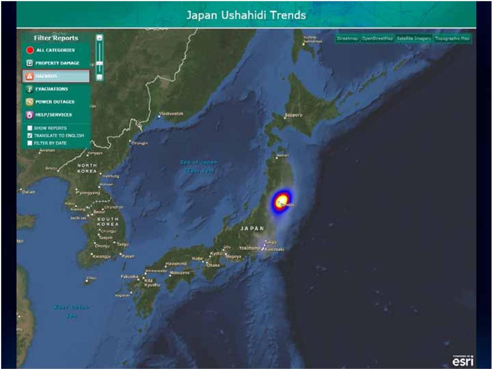
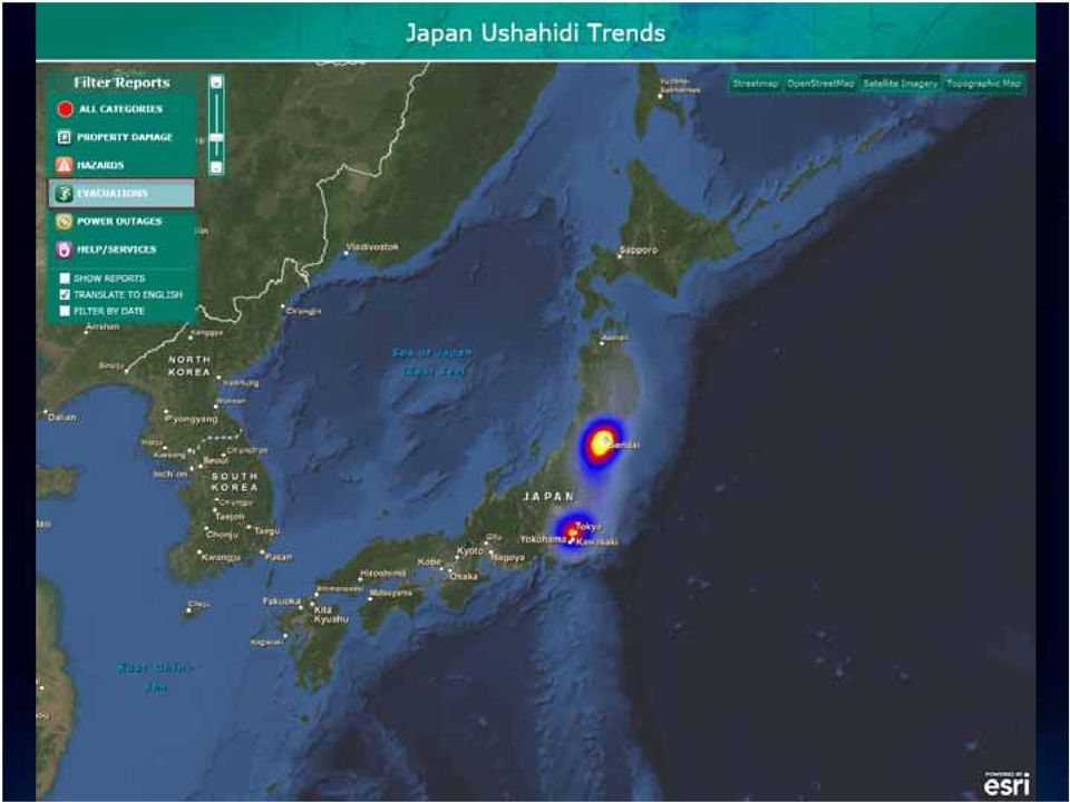
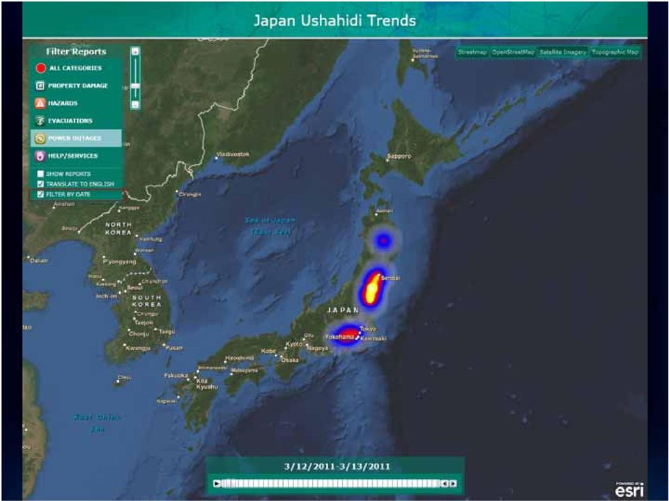
10 Providing Insight

11

12 Ushahidi Crowd Sourcing Tool

13

14

15
16
17

18
19

20

21
22
23
24
25 Documentation
26 Sudan Referendum
27 Who s Tweeting?
28 Concentrated Messages
29 Going Viral
30 Going Viral
31 Going Viral
32 Going Viral
33 Tweets Per Capita
34 Tweets Per Capita
35 Original Content
36 Re-tweets
37 Mass Media
38 Mass Media Conduits
39 Message Spread
40 Sudan Statistics Analysis Results of 20,000 Tweets from January 9 th to 15 th Location Information - 95% of locations came from geocoding a place name in the user's twitter profile % were from a lat / long in the user's profile - 0.5% were GeoTagged Generation of Information - 11% were "original information", ie. they were not retweets and did not contain a URL unless that URL is to twitpic. - 13% were second person messages, basically retweets of messages that would have been classifies are original information. - 75% were "mass media" tweets, basically just links to news outlets (probably sent by clicking the twitter button on the web site)
41 Documentation Types - Videos/Photos/Messages
42 Documentation Damage Photos from Flickr
43 Increase Resiliency
44 Disaster Response 2.0 Social Networks + Location can connect you with your neighbor Enabling communities to help themselves during a crisis...
45 Situational Awareness
46 Situational Awareness The sooner we are able to comprehend the full scope of the disaster, the better able we are to support our citizens and first responders. For that reason, we must seek out and incorporate information provided by the public. Senate Homeland Security Hearing on Social Media as Disaster Communications Tool May 5, 2011
47
48 April 22 St. Louis Tornado
49 Common Operational Picture Social Media Tools
50
51
52
53
54
55
56
57
58
59
60
61
62
63 Volunteered Geographic Information (VGI)
64 Volunteered Geographic Information (VGI) Citizens as Sensors: The World of Volunteered Geography Direct Feature Updating Server Connecting Mobile Workers, The Public... Everyone
65 Metro Nashville 2010 Flood Viewer
66 City of Nashville Citizen Reporting Tool Volunteered Geographic Information (VGI)
67 Hamilton County, TN Storm Damage Reporter
68 A New Generation of Geo-Applications Is Emerging CitySourced.com - Leveraging the Geospatial Platform Creating Fun, Interesting and Useful Apps
69 Collect VGI from your Smartphone iphone, Windows Phone 7 and Android
70 Collecting ICS Mapping Information NAPSG Foundation SoCal Public Safety GIS User Group Workshop
71 Challenges Naughty Words Lack of GeoTagging Privacy Terms of Service
72 Resources / Templates Public Safety Resource Center Templates Public Information Map - Social Media / VGI Template - Common Operational Picture (COP) Template Social Media Widget - Citizen Service Template -
73 Social Media for Emergency Management is Evolving How can you evolve with it? Watch Social Media on map during an incident - Integrate Social Media in to your Public Information maps and Situational Awareness Viewers Explore Volunteered Geographic Information (VGI)
74 Other Resources / Tools ArcGIS.com Tweet Mapping Template Ushahidi ArcGIS Destkop AddIn ArcGIS Explorer 1700 Twitter Add-in Storing tweets in the Geodatabase via GNIP Power Track (
75 ArcGIS.com Tweet Mapping Template See this blog post on the ArcGIS Online blog - hive/2011/05/02/tweet-mapping-template.aspx Three Steps 1. Create your web map 2. Select the Twitter Web Map Template 3. Host html on your website
76 Ushahidi ArcGIS Desktop AddIn (with source)
77 ArcGIS Explorer 1700 Twitter Add-In
78 Storing Twitter Data GNIP Power Track (Product subscription) Filter the Twitter Firehouse Many different filters and Operators - Including the has:geo - Currently, 'has:geo' is about 2-4% of the full firehose - Any tweets with geolocation data, either an exact lat/lon or a named place
79 Demos
80 Questions / Discussion
81
FirstToSee: Leveraging Social Media for Emergency Response. June 21, 2013
 FirstToSee: Leveraging Social Media for Emergency Response June 21, 2013 1 Overview Social media now plays a critical role in how the public communicates during an emergency. The FirstToSee Emergency Support
Quick Start Guide to. ArcGISSM. Online. for Insurance
 Quick Start Guide to ArcGISSM Online for Insurance Historic tracks from tropical storms and hurricanes are overlaid on a map displaying population growth. Quick Start Guide to ArcGIS Online ArcGIS SM Online
Attributes and Objectives of Social Media. What is Social Media? Maximize Reach with Social Media
 What is Social Media? "Social media is an innovative way of socializing where we engage in an open dialogue, tell our stories and interact with one another using online platforms. (Associated Press, 2010)
An Esri White Paper May 2012 ArcGIS for Emergency Management
 An Esri White Paper May 2012 ArcGIS for Emergency Management Esri, 380 New York St., Redlands, CA 92373-8100 USA TEL 909-793-2853 FAX 909-793-5953 E-MAIL info@esri.com WEB esri.com Copyright 2012 Esri
How To Map Human Dynamics With Social Media For Disaster Alerts
 Mapping Human Dynamics with Social Media for Disaster Alerts Dr. Ming-Hsiang Tsou mtsou@mail.sdsu.edu Professor of Geography, Director of the Center for Human Dynamics in the Mobile Age, San Diego State
ArcGIS 10.1 Web Apps and APIs. John Hasthorpe & Kai Hübner
 ArcGIS 10.1 Web Apps and APIs John Hasthorpe & Kai Hübner Overview Options for leveraging ArcGIS Server using Esri s Web APIs Alternatives to the Web ADF application builder (Gone in 10.1) When and how
Quick Start Guide to. ArcGISSM. Online. for Public Accounts
 Quick Start Guide to ArcGISSM Online for Public Accounts Using ArcGIS Online with a Public Account ArcGIS SM Online is a cloud-based mapping platform that allows you to easily and quickly make maps, collaborate,
A Workflow for Creating and Sharing Maps
 A Workflow for Creating and Sharing Maps By Keith Mann, Esri What You Will Need Item Source ArcGIS Online for Organizations subscription ArcGIS 10.1 for Desktop (Any license level) ArcGIS Spatial Analyst
Issues in Information Systems Volume 14, Issue 2, pp.289-297, 2013
 SOCIAL MEDIA WIDGET FOR EMERGENCY RESPONSE Shreeti Banerjee, Illinois State University, sbaner2@ilstu.edu Bryan Hosack, Illinois State University, bhosack@ilstu.edu Billy B. L. Lim, Illinois State University,
Integrating Social Media into Emergency Management Planning
 U.S. Department of Education Office of Safe and Drug-Free Schools Emergency Management for Higher Education FY 2009 Final Grantee Meeting Philadelphia, PA August 5 6, 2010 Integrating Social Media into
Step 1 Preparation and Planning
 Its daunting starting any GIS Web or Mobile project. Where does one begin? This 3 step guide should help you get past your project inertia and start things moving rapidly forward. Step 1 Preparation and
STATEMENT SHAYNE ADAMSKI SENIOR MANAGER OF DIGITAL ENGAGEMENT FEDERAL EMERGENCY MANAGEMENT AGENCY U.S. DEPARTMENT OF HOMELAND SECURITY BEFORE THE
 STATEMENT OF SHAYNE ADAMSKI SENIOR MANAGER OF DIGITAL ENGAGEMENT FEDERAL EMERGENCY MANAGEMENT AGENCY U.S. DEPARTMENT OF HOMELAND SECURITY BEFORE THE COMMITTEE ON HOMELAND SECURITY SUBCOMMITTEE ON EMERGENCY
Using information from social media for emergency management. Bert Brugghemans
 Using information from social media for emergency management Bert Brugghemans Bert Brugghemans Antwerp Fire Service Area manager Emergency manager CCO @bertbrugghemans Do we miss a lot of important information?
ArcGIS Web Mapping. Sam Berg, esri sberg@esri.com
 ArcGIS Web Mapping Sam Berg, esri sberg@esri.com Agenda ArcGIS and WebMaps The APIs ArcGIS for Flex Viewer ArcGIS for Silverlight Builder ArcGIS for Sharepoint ArcGIS Application Templates ArcGIS Runtime
Network Analysis with ArcGIS Online
 Federal GIS Conference February 9 10, 2015 Washington, DC Network Analysis with ArcGIS Online Matt Kennedy Topics Online versus on-premise network analysis services How to access online services How to
Running head: CRISIS COMMUNICATION INCLUDING SOCIAL MEDIA 1
 Running head: CRISIS COMMUNICATION INCLUDING SOCIAL MEDIA 1 Crisis Communications Plans Including Social Media: A Comparative Analysis of Joplin, Missouri s and Moore, Oklahoma s Tornado Crises from a
Conservation Workshop ArcGIS Explorer
 Conservation Workshop ArcGIS Explorer Bern Szukalski bszukalski@esri.com Topics for this session Introduction Overview of features Using ArcGIS Explorer effectively New features & capabilities Customization
Social Media Strategy. Virtual Social Media Working Group and DHS First Responders Group
 Social Media Strategy Virtual Social Media Working Group and DHS First Responders Group January 2012 CONTENTS INTRODUCTION... 2 PURPOSE... 3 BENEFITS OF SOCIAL MEDIA FOR PUBLIC SAFETY... 3 Creating Trust,
Social Media during emergencies
 Social Media during Emergencies Introduction Red Cross Societies around the world, including the Canadian Red Cross, are exploring ways in which social media can affect the efficiency of a disaster response.
Using Crowdsourcing to Enhance Crisis Management
 Using Crowdsourcing to Enhance Crisis Management Alfred C. Weaver and Joseph P. Boyle Department of Computer Science, University of Virginia, Charlottesville, VA 22901, USA Abstract - In the event that
Social media has recently played a critical
 C Y B E R - P H Y S I C A L - S O C I A L S Y S T E M S Editor: Daniel Zeng, University of Arizona, zeng@email.arizona.edu Harnessing the Crowdsourcing Power of Social Media for Disaster Relief Huiji Gao
Quick Start Guide to. ArcGISSM. Online
 Quick Start Guide to ArcGISSM Online ArcGIS Online Quick Start Guide ArcGIS SM Online is a cloud-based mapping platform for organizations. Users get access to dynamic, authoritative content to create,
Social Media Marketing Strategies
 Social Media marketing.ca.uky.edu LISTEN FIRST and visit your wall or feed and begin to build a list of people you want to follow. and research who is talking about the organization, county, events, people.
Data Mining and Analysis in ArcGIS Online Joseph Kerski Education Manager Esri jkerski@esri.com Twitter @josephkerski 303-449-7779 x 18237
 Data Mining and Analysis in ArcGIS Online Joseph Kerski Education Manager Esri jkerski@esri.com Twitter @josephkerski 303-449-7779 x 18237 Joseph Kerski Webinar 1 Goals for this workshop 1. Understanding
White Paper. Freeance Mobile for Cityworks
 White Paper Freeance Mobile for Cityworks Version 1.1 May 2012 Freeance Mobile for Cityworks Freeance Mobile for Cityworks 2012.1 is a mobile application for the following smartphones and tablets: iphone
Intro to Web App Builder. Mark Scott, Solutions Engineer, Esri County Government Team mscott@esri.com
 Intro to Web App Builder Mark Scott, Solutions Engineer, Esri County Government Team mscott@esri.com The ArcGIS Platform enables Web GIS Enabling GIS Everywhere Desktop Web Device Simple Integrated Open
Development of the Company s application development platform. Financing for the first six months of operation.
 Business Plan 2014 1.0 Executive Summary The purpose of this business plan is to raise $150,000 for the development of an iphone and android app development company that will sell applications specific
Social Media Creating an Approach That Will Bring You More Business
 2016 National Congress & Expo For Manufactured and Modular Housing Social Media Creating an Approach That Will Bring You More Business Sponsored by: Presented by: Beth Monicatti-Blank All Season Communications
Mobile Solutions in ArcGIS. Justin Fan
 Mobile Solutions in ArcGIS Justin Fan Agenda Introducing Mobile GIS Esri Mobile GIS solutions Selecting the right Mobile GIS solution Resources Q&A Introducing Mobile GIS What is Mobile GIS? Extends the
Use ArcGIS Online to Manage
 Use ArcGIS Online to Manage Your Own Custom Map Gallery By Keith Mann, Esri Start customizing the template by changing the graphics and the web page title. Wouldn t it be great if you could create a dynamic
Esri GIS Mobile Solutions. John Sharrard jsharrard@esri.com
 Esri GIS Mobile Solutions John Sharrard jsharrard@esri.com If I had asked people what they wanted, they would have said faster horses. Henry Ford Trend: Increase demand for location services Pew Research
Social Media Boot Camp
 Social Media Boot Camp Eğitim Tipi ve Süresi: 3 Days VILT 3 Day VILT Social Media Boot Camp Discover the many ways social media can promote your business and increase sales. Even for seasoned marketing
Use of GIS in Planning and Asset Management
 Use of GIS in Planning and Asset Management Technology Developments and Practical Uses Jay Adams Oklahoma DOT Pam Jurney Cross Timbers Consulting GIS Is Evolving Rapidly Millions Organizations 100 s
Emma Duguid Sweet Adelines International Region 31 Marketing Coordinator Vocal Dimension Chorus
 Emma Duguid Sweet Adelines International Region 31 Marketing Coordinator Vocal Dimension Chorus Why is social media so important? Why use it? Facebook - understanding the medium and how to maximise usage
Storytelling with Maps: Workflows and Best Practices
 Storytelling with Maps: Workflows and Best Practices Introduction What is a story map? Story maps are interactive maps combined with text and other content to tell a story about the world. Typically story
Social Media in Crisis Communications. Eliot Brenner, Director NRC Office of Public Affairs
 Social Media in Crisis Communications Eliot Brenner, Director NRC Office of Public Affairs 1 NEA on NRO Crisis Communications One of the challenges observed by most NROs is that the reaction time in terms
An Esri White Paper April 2011 Geospatial Intelligence for Fusion Centers
 An Esri White Paper April 2011 Geospatial Intelligence for Fusion Centers Esri, 380 New York St., Redlands, CA 92373-8100 USA TEL 909-793-2853 FAX 909-793-5953 E-MAIL info@esri.com WEB esri.com Copyright
Twitter Workshop. Getting the most out of Twitter. David Lakins. info@keymultimedia.co.uk. www.keymultimedia.co.uk/seminars
 Twitter Workshop Getting the most out of Twitter David Lakins info@keymultimedia.co.uk www.keymultimedia.co.uk/seminars Follow me: twitter.com/davidlakins What is Twitter Twitter is very simple yet powerful
How to Build Safer Communities. An Esri White Paper December 2015
 An Esri White Paper December 2015 Copyright 2015 Esri All rights reserved. Printed in the United States of America. The information contained in this document is the exclusive property of Esri. This work
ArcGISSM. Online. The Mapping Platform for Your Organization
 ArcGISSM Online The Mapping Platform for Your Organization ArcGIS Online is a cloud-based platform for making and sharing maps, apps, and other geographic data and content. Knowledge Workers Policy Makers
Tweet Me Up: Social Media Tools and Crisis Management
 Tweet Me Up: Social Media Tools and Crisis Management Partners in Emergency Preparedness Conference 2011 Annie Searle & Emily Oxenford Principal Research Associate Annie Searle & Associates LLC Risk Consultants
Cloud Nine: Developing an Entirely Cloud Based GIS, Asset Management and Work Order System
 Cloud Nine: Developing an Entirely Cloud Based GIS, Asset Management and Work Order System Corrie Bondar 1*, Mark Valentino 2 1 Freese and Nichols, Inc., Raleigh, North Carolina 2 Freese and Nichols, Inc.,
Social Media Glossary of Terms
 Social Media Glossary of Terms A Adsense: Google's pay-per-click, context-relevant program available to blog and web publishers as a way to create revenue. Adwords: advertiser program that populates the
Making Your Mobile Workforce More Efficient
 ArcGIS for Mobile Making Your Mobile Workforce More Efficient What Is Mobile GIS? Mobile geographic information system (GIS) technology extends GIS beyond the office and allows organizations to make accurate,
How To Be Successful With Social Media And Email Marketing
 Brought to you by: ExtremeDigitalMarketing.com B2B Social Media + Email Marketing: Rock Solid Strategies For Doing It Right! Businesses Connecting With Businesses Through The Power Of Social Media! By
Introduction to Social Media
 Introduction to Social Media Today s Discussion Overview of Web 2.0 and social media tools How EPA and other agencies are using these tools Agency and governmentwide policies governing use of tools Case
Build an ArcGIS Online Application
 Build an ArcGIS Online Application Sign into ArcGIS Online for Maryland 1. Open a web browser 2. Go to URL http://maryland.maps.arcgis.com/ 3. Click Sign In in the upper right corner of the web page 4.
Introduction to Web AppBuilder for ArcGIS: JavaScript Apps Made Easy
 Introduction to Web AppBuilder for ArcGIS: JavaScript Apps Made Easy OKSCAUG Pamela Kersh September 22, 2015 The ArcGIS Platform enables Web GIS Enabling GIS Everywhere Desktop Web Device Simple Integrated
Making Your Mobile Workforce More Efficient
 ArcGIS for Mobile Making Your Mobile Workforce More Efficient What Is Mobile GIS? Mobile geographic information system (GIS) technology extends GIS beyond the office and allows organizations to make accurate,
First Steps towards Implementing a Sahana Eden Social Media Dashboard
 First Steps towards Implementing a Sahana Eden Social Media Dashboard Irina Temnikova¹, Dogan Biyikli², Francis Boon³ Bulgarian Academy of Sciences¹, Independent Consultant², Sahana Software Foundation³
Petroleum Web Applications to Support your Business. David Jacob & Vanessa Ramirez Esri Natural Resources Team
 Petroleum Web Applications to Support your Business David Jacob & Vanessa Ramirez Esri Natural Resources Team Agenda Petroleum Web Apps to Support your Business The ArcGIS Location Platform Introduction
Integrating Social Media with B2B Email
 Integrating Social Media with B2B Email Daryl Nielson Marketing Manager Email B2B, HP Mia Dand Enterprise Social Media Marketing Manager, HP The New Paradigm in Email Marketing + SOCIAL MEDIA The Social
IFF SOCIAL MEDIA GUIDE
 IFF SOCIAL MEDIA GUIDE 2014 INTERNATIONAL Table of content Social Media in short:...2 Basic Social Media Guidelines...2 Social Media Use Policy in short...3 The Golden Rules of Social Marketing (Marketo)...4
ESRI Mobile GIS Solutions Overview. Shane Clarke ESRI
 ESRI Mobile GIS Solutions Overview Shane Clarke ESRI Agenda Overview of mobile GIS ESRI mobile GIS Solutions Selecting a mobile GIS solution Q & A 2 Mobile GIS Overview 3 What is mobile GIS? Extension
ArcGIS for. Intelligence
 ArcGIS for ArcGIS for solutions.arcgis.com/intelligence Copyright 2015 Esri. All rights reserved. 146660 DUAL3M7/15rk Briefing Book ArcGIS for Briefing Book ArcGIS Web Application ArcGIS for Create and
Operations Dashboard for ArcGIS
 Federal GIS Conference 2014 February 10 11, 2014 Washington DC Operations Dashboard for ArcGIS Joe Bayles Agenda Esri Strategy toward mobility ios Extend the reach of Web GIS Platform agnostic Native apps/web
COMMUNICATION STRATEGY
 COMMUNICATION STRATEGY Internal Working Plan January 2013 What s inside GUIDING PHILOSOPHY 1 THE POST METHOD 2 COMMUNICATION TOOLS WE USE 3 GUIDELINES FOR ENGAGING 4 STAFFING AND IMPLEMENTATION 4 MONITORING
Building your Server for High Availability and Disaster Recovery. Witt Mathot Danny Krouk
 Building your Server for High Availability and Disaster Recovery Witt Mathot Danny Krouk Terminology Whoa! Resiliency High Availability RTO Round Robin Business Continuity A Spectrum, Not a Switch Backup
Social Media Measurement Meeting Robert Wood Johnson Foundation April 25, 2013 SOCIAL MEDIA MONITORING TOOLS
 Social Media Measurement Meeting Robert Wood Johnson Foundation April 25, 2013 SOCIAL MEDIA MONITORING TOOLS This resource provides a sampling of tools available to produce social media metrics. The list
Innovative Uses of Social Media in Emergency Management
 System Assessment and Validation for Emergency Responders (SAVER) Innovative Uses of Social Media in Emergency Management September 2013 Prepared by Space and Naval Warfare Systems Center Atlantic Approved
Portal for ArcGIS. Satish Sankaran Robert Kircher
 Portal for ArcGIS Satish Sankaran Robert Kircher ArcGIS A Complete GIS Data Management Planning & Analysis Field Mobility Operational Awareness Constituent Engagement End to End Integration Collect, Organize,
ArcGIS Viewer for Silverlight An Introduction
 Esri International User Conference San Diego, California Technical Workshops July 26, 2012 ArcGIS Viewer for Silverlight An Introduction Rich Zwaap Agenda Background Product overview Getting started and
Technology for Small Business
 Technology for Small Business Steinar Knutsen February 2015 Agenda Importance of Online Marketing Online Marketing Blueprint Social Media Networks Tools of the Trade 2 Every 1 Second on the Internet Source:
How To Run A Cloud Computer System
 Cloud Technologies and GIS Nathalie Smith nsmith@esri.com Agenda What is Cloud Computing? How does it work? Cloud and GIS applications Esri Offerings Lots of hype Cloud computing remains the latest, most
Configuring and Extending ArcGIS Solutions Web Applications
 Esri Developer Summit March 8 11, 2016 Palm Springs, CA Configuring and Extending ArcGIS Solutions Web Applications Allison Muise & Mike Tschudi ArcGIS Solutions? ArcGIS as a Platform Simple, Open, and
Dean College Social Media Handbook
 Dean College Social Media Handbook Goals of this Handbook To help Dean College employees and groups engage with social media in constructive and fun ways while contributing to the overall goals of the
Ease of Use No programming, no system administration. Make maps fast with this productivity tool.
 Online Mapping Tools Esri s ArcGIS Online A mapping tool for interactive digital maps Access to map data basemaps and your own data Ease of Use No programming, no system administration. Make maps fast
Easily add Maps and Geo Analytics in MicroStrategy
 Easily add Maps and Geo Analytics in MicroStrategy Agenda Introduction Configure to use Maps in MicroStrategy MicroStrategy Geo Analysis Capabilities and Examples Key Takeaways and Q&A Why Geospatial Analysis
Contents. Meltwater Quick-Start Guide
 Meltwater Quick-Start Guide Contents Introduction... 2 Meltwater at a Glance... 2 Logging in... 3 Account Management... 3 Searches... 4 Keyword Search... 6 Advanced Search... 7 Source Selections... 9 Inbox...
Getting your app together with Web AppBuilder for ArcGIS
 Getting your app together with Web AppBuilder for ArcGIS Walter Simonazzi Walter Simonazzi Session path What is Web AppBuilder for ArcGIS? Web AppBuilder for ArcGIS tour What s new? July 2015 Demos Community
Raise of hands on anyone whos used the Flex or Silverlight Application Builders?
 Raise of hands on whos used the Beta for Web Application Builder? Raise of hands on anyone whos done any web development? Raise of hands on anyone whos used the Flex or Silverlight Application Builders?
Deploying ArcGIS for Server Using Managed Services
 Deploying ArcGIS for Server Using Managed Services Andrew Sakowicz Erin Ross Sridhar Karra Agenda Introduction Program Overview - Overview - Methodology - Tools Customer Deployments - Architecture and
GIS Application for Geotargeted Emergency Alerting in MassAlert TM Solution
 GIS Application for Geotargeted Emergency Alerting in MassAlert TM Solution Egidijus Šilanskas, NT Service www.massalert.eu UAB NT Service 2013 1 What is Emergency Alerting? Emergency Alerting by using
PUBLIC SAFETY. Industry Solutions Harness the Power of GIS for Public Safety
 PUBLIC SAFETY Industry Solutions Harness the Power of GIS for Public Safety Esri has thousands of customers worldwide who are using the transforming power of GIS technology to respond to disasters and
Easy Strategies for using Content (Ctrl) in your Email Marketing Today www.contentctrl.com
 in your Email Marketing Today www.contentctrl.com") Field Guide to the Social Email (R )Evolution Easy Strategies for using Content (Ctrl) in your Email ing Today www.contentctrl.com Welcome To The Party You ve added a social sharing button to your email
Field Guide to the Social Email (R )Evolution Easy Strategies for using Content (Ctrl) in your Email ing Today www.contentctrl.com Welcome To The Party You ve added a social sharing button to your email
GIS for Internal Security. Col (Retd) Richard Sundharam ESRI- India
 Richard Sundharam ESRI- India") GIS for Internal Security Col (Retd) Richard Sundharam ESRI- India What is Internal Security? Internal Security is protecting and sustaining a nation s: Population Economy Infrastructure Borders Overall
GIS for Internal Security Col (Retd) Richard Sundharam ESRI- India What is Internal Security? Internal Security is protecting and sustaining a nation s: Population Economy Infrastructure Borders Overall
Authors: Maggie Ortiz Earthquake Engineering Research Institute. Oakland, CA 94612 Tel: 510-451-0905 Fax: 510-451-5411 maggie@eeri.
 USGS Award Numbers: G14AP00021 & G14AP00022 Start Date: 1/1/2014 End Date: 12/31/2014 Continued Enhancement of California Earthquake Clearinghouse Operations through Improved Data Collection, Sharing,
Lessons Learned in Using Social Media for Disaster Relief - ASU Crisis Response Game
 Lessons Learned in Using Social Media for Disaster Relief - ASU Crisis Response Game Mohammad-Ali Abbasi, Shamanth Kumar, Jose Augusto Andrade Filho, Huan Liu Computer Science and Engineering, Arizona
50 Ways to Use Twitter in the College Classroom
 Home About Blog Contact Us 50 Ways to Use Twitter in the College Classroom Posted by Site Administrator in Tips and Tools on 06 8th, 2009 no responses Twitter has caught fire across many professional fields
Geospatial Software Solutions for the Environment and Natural Resources
 Geospatial Software Solutions for the Environment and Natural Resources Manage and Preserve the Environment and its Natural Resources Our environment and the natural resources it provides play a growing
UNGIWG 14. Steve Maddison, George Davis, Latitude Geographics Friday, May 16 th 2014
 UNGIWG 14 Steve Maddison, George Davis, Latitude Geographics Friday, May 16 th 2014 GIS Challenges Today Spatial Application Infrastructure (SAI) The Geocortex Approach 2 1 Geocortex Essentials Web-based
Creating Web and Mobile Maps Using ArcGIS Online. SCO Technical Paper
 Creating Web and Mobile Maps Using ArcGIS Online SCO Technical Paper Version History Version Date Notes Author/Contact 1.0 February, 2012 Initial document created. John J Czaplewski Copyright 2012 The
Blog, Tweet and Facebook Your Way to Success SELF-PROMOTION THROUGH SOCIAL MEDIA: INSTAGRAM
 Blog, Tweet and Facebook Your Way to Success SELF-PROMOTION THROUGH SOCIAL MEDIA: INSTAGRAM Spring 2013 WHAT IS SOCIAL MEDIA? The term social media refers to forms of electronic communication (websites
Presented by Spyros Mygdanis & Giorgos Kalaitzis
 Presented by Spyros Mygdanis & Giorgos Kalaitzis About this presentation 1. Websites Elements of a successful website 2. Content 3. Internet Marketing Channels 4. Building your online strategy 1. Websites
SUCCESSFUL CROSS-PLATFORM AUDIENCE CAMPAIGNS #POWEROFPR MARISSA PICK DIRECTOR OF SOCIAL MEDIA @MARISSAPICK
 SUCCESSFUL CROSS-PLATFORM AUDIENCE CAMPAIGNS #POWEROFPR MARISSA PICK DIRECTOR OF SOCIAL MEDIA @MARISSAPICK 2 YOUR BRAIN PROCESSES IMAGES 60,000 TIMES QUICKER THAN TEXT. 3 3 4 Photos and images on Facebook
A Personal Cloud Server System for hosting Crowdsourced flood data
 A Personal Cloud Server System for hosting Crowdsourced flood data Contextualized with a case study on a Flood Points Map on the City of West Hollywood, CA Contextualized by Sam Perez Methodology Shapefile
Online Marketing & Social Media for Best of British Parks
 Online Marketing & Social Media for Best of British Parks David Lakins info@keymultimedia.co.uk www.keymultimedia.co.uk/seminars We would like to encourage our 51 members to get involved, or more involved
Disaster Risk Reduction in the Information Age. June 2009. infodev Disaster Risk Reduction in the Information Age 1
 Disaster Risk Reduction in the Information Age June 2009 infodev Disaster Risk Reduction in the Information Age 1 Project Summary The Disaster Risk Reduction in the Information Age (RISK) Project will
Data Fusion Centers. Transforming Public Safety Information into Actionable Knowledge
 Data Fusion Centers Transforming Public Safety Information into Actionable Knowledge Defining Geospatial Data Fusion Homeland security relies on fusion the ability to capture and analyze data from multiple
An Esri White Paper April 2012 GIS for the Insurance Claims Process: Five Steps for an Effective Workflow
 An Esri White Paper April 2012 GIS for the Insurance Claims Process: Five Steps for an Effective Workflow Esri, 380 New York St., Redlands, CA 92373-8100 USA TEL 909-793-2853 FAX 909-793-5953 E-MAIL info@esri.com
What s New in Communication:
 What s New in Communication: The Basics of Social Media Emily Eubanks Education and Media Coordinator Kim Taylor Senior Information Specialist 2009 Florida Master Gardener Continued Training Conference
Use of Social Media in Natural Disaster Management
 Use of Social Media in Natural Disaster Management Dimiter Velev 1 + and Plamena Zlateva 2 1 University of National and World Economy, Sofia, Bulgaria 2 Institute of System Engineering and Robotics - BAS,
Esri Maps for Salesforce and Microsoft Dynamics CRM
 Esri Maps for Salesforce and Microsoft Dynamics CRM Daniel Lee, Lucy Guerra Esri UC 2014 Technical Workshop Agenda CRM and Esri Esri Maps for Demos Road Ahead Esri UC 2014 Technical Workshop Esri Maps
GEOGRAPHIC CONTEXT ANALYSIS OF VOLUNTEERED INFORMATION
 GEOGRAPHIC CONTEXT ANALYSIS OF VOLUNTEERED INFORMATION (GEOCONAVI) Frank O. Ostermann COST Energic Meeting 26.05.2014, Zürich GEOGRAPHIC CONTEXT ANALYSIS OF VOLUNTEERED INFORMATION PRESENTATION OVERVIEW
Fall 2015 GES 4120/5120 Internet GIS
 Fall 2015 GES 4120/5120 Internet GIS Instructor: Dr. Somayeh Dodge Assistant Professor Department of Geography & Environmental Studies website: http://www.uccs.edu/~sdodge/ e-mail: sdodge3@uccs.edu Office:
Content for Twitter. Twitter Module 3
 Content for Twitter Twitter Module 3 Types of tweet, #hashtags and Twitter etiquette This module looks at the different types of tweets, explains #hashtags, explores Twitter etiquette and gives our top
Impressive Analytics
 Impressive Analytics and Insight on a Shoestring Lisa Ikariyama & Tracy Anderson Cabbage Tree Creative www.cabbagetree.co.nz Getting Started Before you design a page on your website or get started with
Leveraging the power of social media & mobile applications
 Leveraging the power of social media & mobile applications Xoriant delivers an innovative solution blending mobile applications and web based social networking media for our client focusing on local marketing.
Video #3 Creating Google Accounts Free SEO Training Roadmap Video Training Series
 Do you find yourself in the position of trying to play catch up by learning, understanding and perhaps integrating Google, Facebook and other online services into your business and feel a little bit overwhelmed?
FLORIDA LOCAL GOVERNMENT INFORMATION SYSTEMS ASSOCIATION TECHNOLOGY ACHIEVEMENT AWARD PROGRAM
 Name of Nominee: Tony Curtis Nominee s Jurisdiction: City of Kissimmee Jurisdiction Population: 2010 Census: 58,698 Nominee s Title: Nominee s Email: Assistant Director, Information Technology Tcurtis@kissimmee.org