Platforms with Sensor on board. Illumination. (Geostationary Satellite) GMS LANDSAT, MOS, SPOT SPACE SHUTTLE HIGH ALTITUDE JETPLANE
|
|
|
- Brianne Kennedy
- 7 years ago
- Views:
Transcription
1 Platforms with Sensor on board Illumination GMS (Geostationary Satellite) LANDSAT, MOS, SPOT SPACE SHUTTLE atmosphere HIGH ALTITUDE JETPLANE emission reflection LOW&MIDDLE ALTITUDE AIRPLANE GROUND TRUTH object
2 Contents - Introduction to RS Principles of Remote Sensing electromagnetic radiation atmospheric interaction surface reflection Remote Sensing systems Platforms Sensors Resolution: spatial, spectral, temporal Applications of Remote Sensing
3 Definition of Remote Sensing Remote Sensing is a method to acquire information about material objects, areas, or phenomenon through the analysis of data acquired by a device from measurements made at a distance, without coming into physical contact with the objects, areas, or phenomena under investigation.

4 Why Remote Sensing?

5 Why Remote Sensing?
6 Why Remote Sensing? To recognize macro-patterns which may not be visible from ground To gain an OVERVIEW of an area To gather information on large areas in short time To gather information cost-effectively To gather information on inaccessible places To replace conventional sources of information (topo sheets, census data etc.)

7 What is Remote Sensing? We acquire much information about our surrounding through the senses of sight and hearing which do not require close contact between the sensing organs and the external objects. In another word, we are performing Remote Sensing all the time. Generally, Remote sensing refers to the activities of recording/ observing/ perceiving (sensing) objects or events at far away (remote) places. Earth from Space
8 How does Remote Sensing Work? Electro-magnetic radiation which is reflected or emitted from an object is the usual source of remote sensing data. A device to detect the electro-magnetic radiation reflected or emitted from an object is called a "remote sensor" or "sensor". Cameras or scanners are examples of remote sensors. A vehicle to carry the sensor is called a "platform". Aircraft or satellites are used as platforms. The characteristics of an object can be determined, using reflected or emitted electromagnetic radiation, from the object. Each object has a unique and different characteristics of reflection or emission if the type of object or the environmental condition is different..
9 Principles of RS: EMR The definition of RS implies the use of medium which carries the information from the object to the sensor Usually, electro-magnetic radiation (EMR) is being used as medium In passive RS, the radiation emitted by some other source is being used In active RS, the radiation is being emitted by the system itself
10 Electro-Magnetic Radiation (EMR) / 2 electric field magnetic field travelling direction λ (wave length)
11 The Electro-Magnetic Spectrum 0.3 (cm) Microwave bands W V O Ka K Ku X C S L P Wavelength: Microwaves 0.1nm 10nm 1µm 100µm 10mm 1m 100m 10km γ -ray X-ray UV Vis. Infrared EHF SHF UHF VHF MF LF VLF Radio waves Ultra Violet v I o l e t Visible Light b l u e g r e e n y e l l o w o r a n g e r e d Near Infra-red Short Wave Infra-red Intermediate Infra-red Thermal Infra-red wavelength (µm)
12 Characteristics of spectral regions Region Wavelength Remarks Gamma Ray <0.03 nm Incoming radiation is completely absorbed by the upper atmosphere and is not available for remote sensing. X-ray 0.03 to 3.0 nm Completely absorbed by the atmosphere. Not employed in remote sensing. Ultraviolet 0.03 to 0.4 µm In-coming wavelengths less than 0.3µm are completely absorbed by ozone in the upper atmosphere. Photographic UV band 0.3 to 0.4 µm Transmitted through the atmosphere. Detectable with film and photodetectors, but atmospheric scattering is severe. Visible 0.4 to 0.7 µm Imaged with film and photo-detectors. Includes the reflected energy peak of earth at 0.5µm. Infrared 0.7 to 100 µm Interaction with matter varies with wavelength. Atmospheric Reflected IR band Thermal IR band transmission windows are separated by absorption bands. 0.7 to 3.0 µm Reflected solar radiation that contains no information about thermal properties of materials. The band from 0.7 to 0.9µm is detectable with film and is called the photographic IR band. 3 to 5 µm 8 to 14µm Principal atmospheric windows in the thermal region. Images at these wavelengths are acquired by optical-mechanical scanners and special videocon systems, but not by film. Microwave 0.1 to 30cm Longer wavelengths can penetrate clouds, fog, and rain. Images may be acquired in the active or passive mode. Radar 0.1 to 30 cm Active form of microwave remote sensing. Radar images are acquired at various wavelength bands. Radio >30 cm Longest wavelength portion of the electro-magnetic spectrum. Some classified radar with very long wavelength operate in this region.
13 Makes use of sensors that detect the reflected or emitted electro-magnetic radiation from natural sources, most notably the sun. Due to its surface temperature of 5800K, the sun emits most of its energy in the visible part of the spectrum. The earth with a surface temperature of 300K emits most of its energy in the thermal part of the spectrum.
14 Spectral emission, atmospheric transmittance and sensor sensitivity Figure (3a) Energy Source Figure (3b) Atmospheric Transmittance Thermal Scanners Figure (3c) Common Remote Sensing Systems
15 Atmospheric Transmittance
16 Interaction between EMR and surfaces

17 Spectral Reflectance Curves
18 Vegetation reflectance curves Chlorophyll absorption Water absorption

19 Mineral Reflectance curves
20 Remote Sensing Systems DATA ACQUISITION DATA ANALYSIS Reference data Pictorial Visual Numerical Quantitative Users Sources of energy Propagation through atmosphere Sensor systems Data products Interpretation procedures Re-transmission through atmosphere Information products Reflection on surface features
21 Platforms Platform Altitude Observation Remarks geostationary satellite 36,000km fixed point observation GMS circular orbit satellite (earth observation) 500km - 1,000km regular observation LANDSAT, SPOT, MOS, etc space shuttle 240km - 350km irregular observations radio - sound 100m - 100km various investigations (meteorological, etc) high altitude jet-plane 10km -12km reconnaissance, wide area investigations low or mid altitude plane 500m - 8,000m various aero investigation surveys helicopter 100m- 2,000m various aero investigation surveys radio-controlled plane below 500m various aero investigation surveys aeroplane, hang-plane m various aero investigation surveys hangglider hang-balloon 800m - various investigations cable 10-40m archaeological investigations crane car 5-50m close range surveys ground measurement car 0-30m ground truth cherry picker
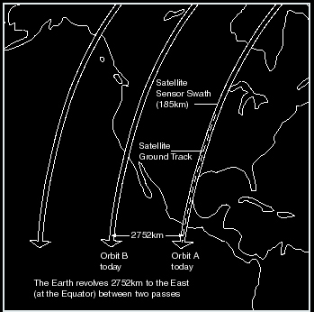
22 Earth Observation Satellite Orbits GROUND TRACK ALTITUDE = 705 KM (Nominal) INCLINATION = 98.2 O Equator crossing: 9:45am (Local time) DIRECTION OF TRAVEL ORBIT PERIOD = 98.9 MINUTES

23 Earth Observation Satellite Orbits / 2
24 Sensors A sensor or remote sensor is a device to detect the electro-magnetic radiation reflected or emitted from an object. Cameras or scanners are examples of remote sensing-sensors.
25 Sensors: Solid State Scanners
26 Sensors: Opto-Mechanical Scanner
27 Characteristics of RS systems: Resolution In general, resolution is defined as the ability of an entire remote-sensing system, including lens, antennae, display, exposure, processing, and other factors, to render a sharply-defined image. Resolution of a remotesensing system is of different types. (1) Spectral Resolution (2) Radiometric Resolution (3) Spatial Resolution (4) Temporal Resolution
28 Spectral Resolution Detectors Incoming light (mix of different wavelengths) Prism or Spectrometer

29 Spectral Resolution / 2 coarse spectral resolution: only 1 value, same for soil and turbid water finer spectral resolution: 3 values, each is different for soil / water
30 Spectral resolution of some RS systems SPOT Pan SPOT XS Landsat TM NOAA AVHRR IRS LISS IRS WiFS ADEOS AVNIR
31 Spectral Band Range (µm) used in Thematic Mapper (TM) onboard Landsat's 4 and 5 sensor system and their potential application Band Band Range Number (µm) Potential applications to 0.52 coastal water mapping; soil/vegetation differentiation; deciduous/coniferous differentiation (sensitive to chlorophyll concentration); etc to 0.62 green reflectance by healthy vegetation; etc to 0.69 chlorophyll absorption for plant species differentiation; to 0.90 bio-mass surveys; water body delineation; to 1.75 vegetation moisture measurement; snow/cloud differentiation; to 12.5 plant heat stress management; other thermal mapping; soil moisture discrimination; to 2.35 hydrothermal mapping; discrimination of mineral and rock types;
32 Spectral Band Range (µm) used in Advance Very High Resolution Radiometer (AVHRR) sensor onboard NOAA Satellite system and their potential application. CHANNEL WAVE LENGTH) USES NUMBER (µm) CHANNEL cloud delineation, weather snow and ice mapping and monitoring, etc. CHANNEL surface water delineation, vegetation and agriculture assessment, range surveys, etc. CHANNEL land/water distinction, sea surface temperature, hot spot detection (forest fires and volcanic activity),etc. CHANNEL day/night cloud mapping, sea and land surface temperature, soil moisture, volcanic eruption, etc. CHANNEL sea surface temperature measurement, soil moisture, weather, etc.


33 Multispectral images: Landsat TM TM6 ( )

34
 SPOT Pan (10m) Landsat TM (30m) IRS WiFS (188m) NOAA AVHRR (1.1km)")
35 Spatial resolution / 2 Landsat MSS (80m) SPOT XS (20m) IRS Pan (6m) KVR (2m) SPOT Pan (10m) Landsat TM (30m) IRS WiFS (188m) NOAA AVHRR (1.1km)
36 Spatial Resolution SATELLITE SYSTEM SOME OPTICAL SENSOR SYSTEM LANDSAT 4/5 MSS LANDSAT 4/5 TM SPOT XS NOAA AVHRR MOS MESSR JERS OPS VINR and SWIR ADEOS AVNIR IRS-1C LISS-III IRS-1C WiFS Spatial Resolution 80 m 30 m 20 m 1.1 km (LAC) 50 m 18 m X 24 m Off-nadir viewing SPOT PAN JERS (side-look) (10m OPS capability for the resolution) VINR (PAN) µm (18m X Panchromatic 3 days revisit 24m) mode for stereo capability Bands 3 & image data 4 acquisition) µm 16 m 24 m 188 m (200 m) ADEOS IRS-1C PAN AVNIR (6 m PAN resolution) (8 m (70 km swath Resolution) width) µm 0.72 µm (6-bit)


37 Spatial resolution: TM and SPOT Pan
38 Temporal resolution SATELLITE LANDSAT LANDSAT SPOT NOAA MOS JERS ADEOS IRS-1C IRS-1C SYSTEM MSS TM XS AVHRR MESSR OPS AVNIR LISS-III WiFS VINR AND SWIR Revisit Cycle (nadir) 1 image/day (nadir) 24 (nadir) (in days)
39 Quantization level of remote-sensing data Sensor Satellite Level (bit) Descriptions MSS LANDSAT 6 8 bits data after radiometric correction TM LANDSAT 8 HRV (XS) SPOT 8 HRV (PA) SPOT 6 AVHRR NOAA 10 both 10 and 16 bits data are available at distribution SAR JERS-1 3 real 3 bits, imaginary 3 bits
 view of any places of the Earth surface, which helps to study, map, and monitor the Earth s surface at local")
40 Remote Sensing Satellite The remote sensing satellites are equipped with sensors looking down to the earth. They are the "eyes in the sky" constantly observing the earth as they move around the earth. Remote Sensing Satellite Remote Sensing satellite images gives a synoptic (bird s eye) view of any places of the Earth surface, which helps to study, map, and monitor the Earth s surface at local and/or regional/global scales. It is cost effective and gives better spatial coverage as compared to ground sampling.
41 Types of Remote Sensing Images There are several remote sensing satellite series in operation. Different satellite systems have different characteristics, e.g. resolutions, number of bands, and have their own importance for different application. Satellite Systems Spatial Resolution Type Number of Bands Launched by LANDSAT-ETM+ LANDSAT-TM LANDSAT-MSS SPOT-XS SPOT-PAN IRS-1C PAN IRS-LISS-III IRS-WiFS Cosmos -KVR1000 IKONOS IKONOS ADEOS-AVNIR M NOAA AVHRR MOS MESSR 15,30,50 30m 80m 20m 10m 6m 24m 188m 2m 1m 4m 16m 1.1Km 50m Multi-spectral Multi-spectral Multi-spectral Multi-spectral Panchromatic Panchromatic Multi-spectral Multi-spectral Panchromatic Panchromatic Multi-spectral Multi-spectral Multi-spectral Multi-spectral USA USA USA France, Sweden France, Sweden India India India Russia/USA Canada Canada Japan USA Japan
42
43 SATELLITE LANDSAT LANDSAT4/5 SPOT NOAA MOS JERS ADEOS IRS-1C IRS-1C SYSTEM 4/5 TM XS AVHRR MESSR OPS AVNIR LISS-III WiFS SOME VINR MSS OPTICAL and SENSOR SWIR SYSTEM Spectral Resolution (Number of Bands) Four Seven Three Five Four Seven Four Four Two Spectral ranges (wave-length portion of EMR) in µm (micrometers) Blue Green Red NIR NIR IIR IIR IIR (MIR) IIR (MIR) ThIR FIR


44 Remote Sensing Images Remote sensing images are normally in the form of digital images. Image processing techniques are applied to enhance the image to help visual interpretation, information extraction and to correct or restore the image if the image has been subjected to geometric distortion, blurring or degradation by other factors. There are many image analysis techniques available and the methods used depending upon the requirements of the specific problem concerned. Satellite Image of Kathmandu
Resolutions of Remote Sensing
 Resolutions of Remote Sensing 1. Spatial (what area and how detailed) 2. Spectral (what colors bands) 3. Temporal (time of day/season/year) 4. Radiometric (color depth) Spatial Resolution describes how
A remote sensing instrument collects information about an object or phenomenon within the
 Satellite Remote Sensing GE 4150- Natural Hazards Some slides taken from Ann Maclean: Introduction to Digital Image Processing Remote Sensing the art, science, and technology of obtaining reliable information
Hyperspectral Satellite Imaging Planning a Mission
 Hyperspectral Satellite Imaging Planning a Mission Victor Gardner University of Maryland 2007 AIAA Region 1 Mid-Atlantic Student Conference National Institute of Aerospace, Langley, VA Outline Objective
2.3 Spatial Resolution, Pixel Size, and Scale
 Section 2.3 Spatial Resolution, Pixel Size, and Scale Page 39 2.3 Spatial Resolution, Pixel Size, and Scale For some remote sensing instruments, the distance between the target being imaged and the platform,
SAMPLE MIDTERM QUESTIONS
 Geography 309 Sample MidTerm Questions Page 1 SAMPLE MIDTERM QUESTIONS Textbook Questions Chapter 1 Questions 4, 5, 6, Chapter 2 Questions 4, 7, 10 Chapter 4 Questions 8, 9 Chapter 10 Questions 1, 4, 7
Electromagnetic Radiation (EMR) and Remote Sensing
 and Remote Sensing") Electromagnetic Radiation (EMR) and Remote Sensing 1 Atmosphere Anything missing in between? Electromagnetic Radiation (EMR) is radiated by atomic particles at the source (the Sun), propagates through
Electromagnetic Radiation (EMR) and Remote Sensing 1 Atmosphere Anything missing in between? Electromagnetic Radiation (EMR) is radiated by atomic particles at the source (the Sun), propagates through
Remote Sensing Satellite Information Sheets Geophysical Institute University of Alaska Fairbanks
 Remote Sensing Satellite Information Sheets Geophysical Institute University of Alaska Fairbanks ASTER Advanced Spaceborne Thermal Emission and Reflection Radiometer AVHRR Advanced Very High Resolution
Review for Introduction to Remote Sensing: Science Concepts and Technology
 Review for Introduction to Remote Sensing: Science Concepts and Technology Ann Johnson Associate Director ann@baremt.com Funded by National Science Foundation Advanced Technological Education program [DUE
Mapping Earth from Space Remote sensing and satellite images. Remote sensing developments from war
 Mapping Earth from Space Remote sensing and satellite images Geomatics includes all the following spatial technologies: a. Cartography "The art, science and technology of making maps" b. Geographic Information
Preface. Ko Ko Lwin Division of Spatial Information Science University of Tsukuba 2008
 1 Preface Remote Sensing data is one of the primary data sources in GIS analysis. The objective of this material is to provide fundamentals of Remote Sensing technology and its applications in Geographical
Overview. What is EMR? Electromagnetic Radiation (EMR) LA502 Special Studies Remote Sensing
 LA502 Special Studies Remote Sensing") LA502 Special Studies Remote Sensing Electromagnetic Radiation (EMR) Dr. Ragab Khalil Department of Landscape Architecture Faculty of Environmental Design King AbdulAziz University Room 103 Overview What
LA502 Special Studies Remote Sensing Electromagnetic Radiation (EMR) Dr. Ragab Khalil Department of Landscape Architecture Faculty of Environmental Design King AbdulAziz University Room 103 Overview What
Remote Sensing. Vandaag. Voordelen Remote Sensing Wat is Remote Sensing? Vier elementen Remote Sensing systeem
 Remote Sensing 1 Vandaag Voordelen Remote Sensing Wat is Remote Sensing? Vier elementen Remote Sensing systeem 2 Nederland Vanaf 700 km hoogte Landsat TM mozaïek 3 Europa vanaf 36000 km hoogte 4 5 Mount
APPLICATION OF TERRA/ASTER DATA ON AGRICULTURE LAND MAPPING. Genya SAITO*, Naoki ISHITSUKA*, Yoneharu MATANO**, and Masatane KATO***
 APPLICATION OF TERRA/ASTER DATA ON AGRICULTURE LAND MAPPING Genya SAITO*, Naoki ISHITSUKA*, Yoneharu MATANO**, and Masatane KATO*** *National Institute for Agro-Environmental Sciences 3-1-3 Kannondai Tsukuba
Selecting the appropriate band combination for an RGB image using Landsat imagery
 Selecting the appropriate band combination for an RGB image using Landsat imagery Ned Horning Version: 1.0 Creation Date: 2004-01-01 Revision Date: 2004-01-01 License: This document is licensed under a
Spectral Response for DigitalGlobe Earth Imaging Instruments
 Spectral Response for DigitalGlobe Earth Imaging Instruments IKONOS The IKONOS satellite carries a high resolution panchromatic band covering most of the silicon response and four lower resolution spectral
How Landsat Images are Made
 How Landsat Images are Made Presentation by: NASA s Landsat Education and Public Outreach team June 2006 1 More than just a pretty picture Landsat makes pretty weird looking maps, and it isn t always easy
D.S. Boyd School of Earth Sciences and Geography, Kingston University, U.K.
 PHYSICAL BASIS OF REMOTE SENSING D.S. Boyd School of Earth Sciences and Geography, Kingston University, U.K. Keywords: Remote sensing, electromagnetic radiation, wavelengths, target, atmosphere, sensor,
1. Introduction. FER-Zagreb, Satellite communication systems 2011/12
 1. Introduction Topics History Characteristics of satellite communications Frequencies Application 1 History Arthur C. Clark suggested in 1945. Earth coverage with 3 geostationary satellites. On 4th of
Remote sensing is the collection of data without directly measuring the object it relies on the
 Chapter 8 Remote Sensing Chapter Overview Remote sensing is the collection of data without directly measuring the object it relies on the reflectance of natural or emitted electromagnetic radiation (EMR).
16 th IOCCG Committee annual meeting. Plymouth, UK 15 17 February 2011. mission: Present status and near future
 16 th IOCCG Committee annual meeting Plymouth, UK 15 17 February 2011 The Meteor 3M Mt satellite mission: Present status and near future plans MISSION AIMS Satellites of the series METEOR M M are purposed
Geography 403 Lecture 7 Scanners, Thermal, and Microwave
 Geography 403 Lecture 7 Scanners, Thermal, and Microwave Needs: Lect_403_7.ppt A. Basics of Passive Electric Sensors 1. Sensors absorb EMR and produce some sort of response, such as voltages differences
Digital Remote Sensing Data Processing Digital Remote Sensing Data Processing and Analysis: An Introduction and Analysis: An Introduction
 Digital Remote Sensing Data Processing Digital Remote Sensing Data Processing and Analysis: An Introduction and Analysis: An Introduction Content Remote sensing data Spatial, spectral, radiometric and
Design of a High Resolution Multispectral Scanner for Developing Vegetation Indexes
 Design of a High Resolution Multispectral Scanner for Developing Vegetation Indexes Rishitosh kumar sinha*, Roushan kumar mishra, Sam jeba kumar, Gunasekar. S Dept. of Instrumentation & Control Engg. S.R.M
Using Remote Sensing Imagery to Evaluate Post-Wildfire Damage in Southern California
 Graham Emde GEOG 3230 Advanced Remote Sensing February 22, 2013 Lab #1 Using Remote Sensing Imagery to Evaluate Post-Wildfire Damage in Southern California Introduction Wildfires are a common disturbance
NATIONAL OPEN UNIVERSITY OF NIGERIA SCHOOL OF SCIENCE AND TECHNOLOGY COURSE CODE: ESM 392
 NATIONAL OPEN UNIVERSITY OF NIGERIA SCHOOL OF SCIENCE AND TECHNOLOGY COURSE CODE: ESM 392 COURSE TITLE: REMOTE SENSING AND RADIATION PRINCIPLES MODULE 1 [INTRODUCTION TO REMOTE SENSING AND RADIATION PRINCIPLES]
Example of an end-to-end operational. from heat waves
 Example of an end-to-end operational service in support to civil protection from heat waves Paolo Manunta pkt006-11-1.0 1.0_WEBGIS Athens, 8 June 2007 OUTLINE Heat Island definition and causes Heat Island
Active and Passive Microwave Remote Sensing
 Active and Passive Microwave Remote Sensing Passive remote sensing system record EMR that was reflected (e.g., blue, green, red, and near IR) or emitted (e.g., thermal IR) from the surface of the Earth.
Overview of the IR channels and their applications
 Ján Kaňák Slovak Hydrometeorological Institute Jan.kanak@shmu.sk Overview of the IR channels and their applications EUMeTrain, 14 June 2011 Ján Kaňák, SHMÚ 1 Basics in satellite Infrared image interpretation
High Resolution Information from Seven Years of ASTER Data
 High Resolution Information from Seven Years of ASTER Data Anna Colvin Michigan Technological University Department of Geological and Mining Engineering and Sciences Outline Part I ASTER mission Terra
Clouds and the Energy Cycle
 August 1999 NF-207 The Earth Science Enterprise Series These articles discuss Earth's many dynamic processes and their interactions Clouds and the Energy Cycle he study of clouds, where they occur, and
After a wave passes through a medium, how does the position of that medium compare to its original position?
 Light Waves Test Question Bank Standard/Advanced Name: Question 1 (1 point) The electromagnetic waves with the highest frequencies are called A. radio waves. B. gamma rays. C. X-rays. D. visible light.
REMOTE SENSING AND ENVIRONMENTAL MONITORING. P. M. Mather School of Geography, The University of Nottingham, U.K.
 REMOTE SENSING AND ENVIRONMENTAL MONITORING P. M. Mather School of Geography, The University of Nottingham, U.K. Keywords: Earth observation, image processing, lidar, pattern recognition, radar Contents
Tech Bulletin. Understanding Solar Performance
 Tech Bulletin Understanding Solar Performance Bekaert solar control window films use advanced technology to benefit consumers with quality solutions that enhance comfort and decrease energy use. By understanding
Introduction to Remote Sensing and Image Processing
 Introduction to Remote Sensing and Image Processing Of all the various data sources used in GIS, one of the most important is undoubtedly that provided by remote sensing. Through the use of satellites,
WATER BODY EXTRACTION FROM MULTI SPECTRAL IMAGE BY SPECTRAL PATTERN ANALYSIS
 WATER BODY EXTRACTION FROM MULTI SPECTRAL IMAGE BY SPECTRAL PATTERN ANALYSIS Nguyen Dinh Duong Department of Environmental Information Study and Analysis, Institute of Geography, 18 Hoang Quoc Viet Rd.,
From lowest energy to highest energy, which of the following correctly orders the different categories of electromagnetic radiation?
 From lowest energy to highest energy, which of the following correctly orders the different categories of electromagnetic radiation? From lowest energy to highest energy, which of the following correctly
ENVIRONMENTAL MONITORING Vol. I - Remote Sensing (Satellite) System Technologies - Michael A. Okoye and Greg T. Koeln
 System Technologies - Michael A. Okoye and Greg T. Koeln") REMOTE SENSING (SATELLITE) SYSTEM TECHNOLOGIES Michael A. Okoye and Greg T. Earth Satellite Corporation, Rockville Maryland, USA Keywords: active microwave, advantages of satellite remote sensing, atmospheric
REMOTE SENSING (SATELLITE) SYSTEM TECHNOLOGIES Michael A. Okoye and Greg T. Earth Satellite Corporation, Rockville Maryland, USA Keywords: active microwave, advantages of satellite remote sensing, atmospheric
What is Solar Control?
 A better environment inside and out. Solar, Safety and Security Window Films: Tech Bulletin Understanding Solar Performance Solar Gard solar control window films use advanced technology to benefit consumers
RS platforms. Fabio Dell Acqua - Gruppo di Telerilevamento
 RS platforms Platform vs. instrument Sensor Platform Instrument The remote sensor can be ideally represented as an instrument carried by a platform Platforms Remote Sensing: Ground-based air-borne space-borne
COLLATED QUESTIONS: ELECTROMAGNETIC RADIATION
 COLLATED QUESTIONS: ELECTROMAGNETIC RADIATION 2011(2): WAVES Doppler radar can determine the speed and direction of a moving car. Pulses of extremely high frequency radio waves are sent out in a narrow
Principle of Thermal Imaging
 Section 8 All materials, which are above 0 degrees Kelvin (-273 degrees C), emit infrared energy. The infrared energy emitted from the measured object is converted into an electrical signal by the imaging
INTRODUCTION TO REMOTE SENSING
 INTRODUCTION TO REMOTE SENSING Dr Robert Sanderson New Mexico State University Satellite picture of Las Cruces, NM Table of Contents Introduction...1 Electromagnetic energy...1 Reflection and absorption...2
STAAR Science Tutorial 30 TEK 8.8C: Electromagnetic Waves
 Name: Teacher: Pd. Date: STAAR Science Tutorial 30 TEK 8.8C: Electromagnetic Waves TEK 8.8C: Explore how different wavelengths of the electromagnetic spectrum such as light and radio waves are used to
A Canada Centre for Remote Sensing Remote Sensing Tutorial
 Fundamentals of Remote Sensing A Remote Sensing Tutorial Natural Resources Canada Ressources naturelles Canada Fundamentals of Remote Sensing - Table of Contents Page 2 Table of Contents 1. Introduction
MAKING SENSE OF ENERGY Electromagnetic Waves
 Adapted from State of Delaware TOE Unit MAKING SENSE OF ENERGY Electromagnetic Waves GOALS: In this Part of the unit you will Learn about electromagnetic waves, how they are grouped, and how each group
Evaluation of the Effect of Upper-Level Cirrus Clouds on Satellite Retrievals of Low-Level Cloud Droplet Effective Radius
 Evaluation of the Effect of Upper-Level Cirrus Clouds on Satellite Retrievals of Low-Level Cloud Droplet Effective Radius F.-L. Chang and Z. Li Earth System Science Interdisciplinary Center University
Monitoring Soil Moisture from Space. Dr. Heather McNairn Science and Technology Branch Agriculture and Agri-Food Canada heather.mcnairn@agr.gc.
 Monitoring Soil Moisture from Space Dr. Heather McNairn Science and Technology Branch Agriculture and Agri-Food Canada heather.mcnairn@agr.gc.ca What is Remote Sensing? Scientists turn the raw data collected
What s better than a milliondollar
 F o r k i d s o f a l l a g e s BY MEMORIE YASUDA What s better than a milliondollar view from the top of a skyscraper? Try a multimillion-dollar view from a satellite flying around Earth. A satellite
Treasure Hunt. Lecture 2 How does Light Interact with the Environment? EMR Principles and Properties. EMR and Remote Sensing
 Lecture 2 How does Light Interact with the Environment? Treasure Hunt Find and scan all 11 QR codes Choose one to watch / read in detail Post the key points as a reaction to http://www.scoop.it/t/env202-502-w2
Light as a Wave. The Nature of Light. EM Radiation Spectrum. EM Radiation Spectrum. Electromagnetic Radiation
 The Nature of Light Light and other forms of radiation carry information to us from distance astronomical objects Visible light is a subset of a huge spectrum of electromagnetic radiation Maxwell pioneered
Joint Polar Satellite System (JPSS)
") Joint Polar Satellite System (JPSS) John Furgerson, User Liaison Joint Polar Satellite System National Environmental Satellite, Data, and Information Service National Oceanic and Atmospheric Administration
Joint Polar Satellite System (JPSS) John Furgerson, User Liaison Joint Polar Satellite System National Environmental Satellite, Data, and Information Service National Oceanic and Atmospheric Administration
Q1. The diagram below shows the range of wavelengths and frequencies for all the types of radiation in the electromagnetic spectrum.
 Q. The diagram below shows the range of wavelengths and frequencies for all the types of radiation in the electromagnetic spectrum. X rays, which have frequencies in the range 0 8 0 2 Hz are already marked
INVESTIGA I+D+i 2013/2014
 INVESTIGA I+D+i 2013/2014 SPECIFIC GUIDELINES ON AEROSPACE OBSERVATION OF EARTH Text by D. Eduardo de Miguel October, 2013 Introducction Earth observation is the use of remote sensing techniques to better
Chapter Contents Page No
 Chapter Contents Page No Preface Acknowledgement 1 Basics of Remote Sensing 1 1.1. Introduction 1 1.2. Definition of Remote Sensing 1 1.3. Principles of Remote Sensing 1 1.4. Various Stages in Remote Sensing
NCDC s SATELLITE DATA, PRODUCTS, and SERVICES
 **** NCDC s SATELLITE DATA, PRODUCTS, and SERVICES Satellite data and derived products from NOAA s satellite systems are available through the National Climatic Data Center. The two primary systems are
The Electromagnetic Spectrum
 INTRODUCTION The Electromagnetic Spectrum I. What is electromagnetic radiation and the electromagnetic spectrum? What do light, X-rays, heat radiation, microwaves, radio waves, and gamma radiation have
The Earth s Atmosphere
 THE SUN-EARTH SYSTEM III The Earth s Atmosphere Composition and Distribution of the Atmosphere The composition of the atmosphere and the way its gases interact with electromagnetic radiation determine
Information Contents of High Resolution Satellite Images
 Information Contents of High Resolution Satellite Images H. Topan, G. Büyüksalih Zonguldak Karelmas University K. Jacobsen University of Hannover, Germany Keywords: satellite images, mapping, resolution,
SPOT Satellite Earth Observation System Presentation to the JACIE Civil Commercial Imagery Evaluation Workshop March 2007
 SPOT Satellite Earth Observation System Presentation to the JACIE Civil Commercial Imagery Evaluation Workshop March 2007 Topics Presented Quick summary of system characteristics Formosat-2 Satellite Archive
Introduction. Stefano Ferrari. Università degli Studi di Milano stefano.ferrari@unimi.it. Elaborazione delle immagini (Image processing I)
") Introduction Stefano Ferrari Università degli Studi di Milano stefano.ferrari@unimi.it Elaborazione delle immagini (Image processing I) academic year 2011 2012 Image processing Computer science concerns
Introduction Stefano Ferrari Università degli Studi di Milano stefano.ferrari@unimi.it Elaborazione delle immagini (Image processing I) academic year 2011 2012 Image processing Computer science concerns
Current status and Future Prospects of Indian Satellite
 Current status and Future Prospects of Indian Satellite Devendra singh and Sanjiv Nair Ministry of science and Technology Department of Science and technology Technology Bhawan,New Mehrauli Road, New Delhi-110016
Finding and Downloading Landsat Data from the U.S. Geological Survey s Global Visualization Viewer Website
 January 1, 2013 Finding and Downloading Landsat Data from the U.S. Geological Survey s Global Visualization Viewer Website All Landsat data are available to the public at no cost from U.S. Geological Survey
'Developments and benefits of hydrographic surveying using multispectral imagery in the coastal zone
 Abstract With the recent launch of enhanced high-resolution commercial satellites, available imagery has improved from four-bands to eight-band multispectral. Simultaneously developments in remote sensing
Radiation Transfer in Environmental Science
 Radiation Transfer in Environmental Science with emphasis on aquatic and vegetation canopy media Autumn 2008 Prof. Emmanuel Boss, Dr. Eyal Rotenberg Introduction Radiation in Environmental sciences Most
Research on Soil Moisture and Evapotranspiration using Remote Sensing
 Research on Soil Moisture and Evapotranspiration using Remote Sensing Prof. dr. hab Katarzyna Dabrowska Zielinska Remote Sensing Center Institute of Geodesy and Cartography 00-950 Warszawa Jasna 2/4 Field
Experiment #5: Qualitative Absorption Spectroscopy
 Experiment #5: Qualitative Absorption Spectroscopy One of the most important areas in the field of analytical chemistry is that of spectroscopy. In general terms, spectroscopy deals with the interactions
for Communication Systems Protection EMI CD-ROM INCLUDED
 Krešimir Malarić EMI Protection for Communication Systems CD-ROM INCLUDED Contents Preface xiii CHAPTER 1 Communications Systems 1 1.1 Components of Communications Systems 1 1.2 Transmitter Systems 2 1.2.1
Earth remote sensing systems of middle and low resolution
 Earth remote sensing systems of middle and low resolution Serial on-line remote sensing satellites delivering data available on the world market V.I. Gershenzon (ScanEx R&D Center) In 1980, graduated from
Passive Remote Sensing of Clouds from Airborne Platforms
 Passive Remote Sensing of Clouds from Airborne Platforms Why airborne measurements? My instrument: the Solar Spectral Flux Radiometer (SSFR) Some spectrometry/radiometry basics How can we infer cloud properties
Table of Contents. An Introduction to Hyperspectral Imaging Technology
 Table of Contents 1.0 Introduction... 1 2.0 Electromagnetic Radiation... 1 2.1 The Electromagnetic Spectrum... 2 2.2 Electromagnetic Interactions with Matter... 3 3.0 Spectroscopy... 5 3.1 Refraction and
Examples of Uniform EM Plane Waves
 Examples of Uniform EM Plane Waves Outline Reminder of Wave Equation Reminder of Relation Between E & H Energy Transported by EM Waves (Poynting Vector) Examples of Energy Transport by EM Waves 1 Coupling
Remote Sensing an Introduction
 Remote Sensing an Introduction Seminar: Space is the Place Referenten: Anica Huck & Michael Schlund Remote Sensing means the observation of, or gathering information about, a target by a device separated
See Lab 8, Natural Resource Canada RS Tutorial web pages Tues 3/24 Supervised land cover classification See Lab 9, NR Canada RS Tutorial web pages
 SFR 406 Remote Sensing, Image Interpretation and Forest Mapping EXAM # 2 (23 April 2015) REVIEW SHEET www.umaine.edu/mial/courses/sfr406/index.htm (Lecture powerpoint & notes) TOPICS COVERED ON 2 nd EXAM:
RESULTS FROM A SIMPLE INFRARED CLOUD DETECTOR
 RESULTS FROM A SIMPLE INFRARED CLOUD DETECTOR A. Maghrabi 1 and R. Clay 2 1 Institute of Astronomical and Geophysical Research, King Abdulaziz City For Science and Technology, P.O. Box 6086 Riyadh 11442,
Passive remote sensing systems record electromagnetic energy that was reflected (e.g., blue, green, red, and near-infrared light) or emitted (e.g.
 or emitted (e.g.") CHAPTER 9: Active and Passive Microwave RS REFERENCE: Remote Sensing of the Environment John R. Jensen (2007) Second Edition Pearson Prentice Hall Passive Remote Sensing Passive remote sensing systems
CHAPTER 9: Active and Passive Microwave RS REFERENCE: Remote Sensing of the Environment John R. Jensen (2007) Second Edition Pearson Prentice Hall Passive Remote Sensing Passive remote sensing systems
CHAPTER 2 Energy and Earth
 CHAPTER 2 Energy and Earth This chapter is concerned with the nature of energy and how it interacts with Earth. At this stage we are looking at energy in an abstract form though relate it to how it affect
8.2 Cells and Energy. What is photosynthesis? Photosynthesis takes place in the chloroplasts. CHAPTER 8. Solar cells and chloroplasts
 CHAPTER 8 CELL PROCESSES 8.2 Cells and Energy To stay alive, you need a constant supply of energy. You need energy to move, think, grow, and even sleep. Where does that energy come from? It all starts
The Electromagnetic Spectrum
 The Electromagnetic Spectrum This flipchart has been adapted from original work, distributed by download or viewed on the Internet, as a free GCSE physics teaching resource by Andy Darvill, physics teacher,
The most widely used active remote sensing systems include:
 Active and Passive Remote Sensing Passive remote sensing systems record EMR that is reflected (e.g., blue, green, red, and near-infrared light) or emitted (e.g., thermal infrared energy) from the surface
ESCI 107/109 The Atmosphere Lesson 2 Solar and Terrestrial Radiation
 ESCI 107/109 The Atmosphere Lesson 2 Solar and Terrestrial Radiation Reading: Meteorology Today, Chapters 2 and 3 EARTH-SUN GEOMETRY The Earth has an elliptical orbit around the sun The average Earth-Sun
CBERS Program Update Jacie 2011. Frederico dos Santos Liporace AMS Kepler liporace@amskepler.com
 CBERS Program Update Jacie 2011 Frederico dos Santos Liporace AMS Kepler liporace@amskepler.com Overview CBERS 3 and 4 characteristics Differences from previous CBERS satellites (CBERS 1/2/2B) Geometric
5. The Nature of Light. Does Light Travel Infinitely Fast? EMR Travels At Finite Speed. EMR: Electric & Magnetic Waves
 5. The Nature of Light Light travels in vacuum at 3.0. 10 8 m/s Light is one form of electromagnetic radiation Continuous radiation: Based on temperature Wien s Law & the Stefan-Boltzmann Law Light has
Using Remote Sensing to Monitor Soil Carbon Sequestration
 Using Remote Sensing to Monitor Soil Carbon Sequestration E. Raymond Hunt, Jr. USDA-ARS Hydrology and Remote Sensing Beltsville Agricultural Research Center Beltsville, Maryland Introduction and Overview
INTA AIRBORNE REMOTE SENSING FACILITY from the Hasselblad s cameras to the SensyTech-AHS sensor
 INTA AIRBORNE REMOTE SENSING FACILITY from the Hasselblad s cameras to the SensyTech-AHS sensor José-Antonio Gómez-Sánchez gomezsj@inta.es Remote Sensing Laboratory INSTITUTO NACIONAL DE TÉCNICA AEROESPACIAL
Satellite Remote Sensing of Volcanic Ash
 Marco Fulle www.stromboli.net Satellite Remote Sensing of Volcanic Ash Michael Pavolonis NOAA/NESDIS/STAR SCOPE Nowcasting 1 Meeting November 19 22, 2013 1 Outline Getty Images Volcanic ash satellite remote
Land Use/Land Cover Map of the Central Facility of ARM in the Southern Great Plains Site Using DOE s Multi-Spectral Thermal Imager Satellite Images
 Land Use/Land Cover Map of the Central Facility of ARM in the Southern Great Plains Site Using DOE s Multi-Spectral Thermal Imager Satellite Images S. E. Báez Cazull Pre-Service Teacher Program University
TUTORIAL Extraction of Geospatial Information from High Spatial Resolution Optical Satellite Sensors
 TUTORIAL Extraction of Geospatial Information from High Spatial Resolution Optical Satellite Sensors E. Baltsavias 1,L. Zhang 2, D. Holland 3, P.K. Srivastava 4, B. Gopala Krishna 4, T.P. Srinivasan 4
Introduction to teledection
 Introduction to teledection Formation Sébastien Clerc, ACRI-ST sebastien.clerc@acri-st.fr ACRI-ST Earth Observation Actors and Markets 2 Earth Observation economic importance Earth Observation is one of
Two primary advantages of radars: all-weather and day /night imaging
 Lecture 0 Principles of active remote sensing: Radars. Objectives: 1. Radar basics. Main types of radars.. Basic antenna parameters. Required reading: G: 8.1, p.401-40 dditional/advanced reading: Online
ATM S 111, Global Warming: Understanding the Forecast
 ATM S 111, Global Warming: Understanding the Forecast DARGAN M. W. FRIERSON DEPARTMENT OF ATMOSPHERIC SCIENCES DAY 1: OCTOBER 1, 2015 Outline How exactly the Sun heats the Earth How strong? Important concept
Photosynthesis and Light in the Ocean Adapted from The Fluid Earth / Living Ocean Heather Spalding, UH GK-12 program
 Photosynthesis and Light in the Ocean Adapted from The Fluid Earth / Living Ocean Heather Spalding, UH GK-12 program Algae, like your Halimeda, and plants live in very different environments, but they
Studying cloud properties from space using sounder data: A preparatory study for INSAT-3D
 Studying cloud properties from space using sounder data: A preparatory study for INSAT-3D Munn V. Shukla and P. K. Thapliyal Atmospheric Sciences Division Atmospheric and Oceanic Sciences Group Space Applications
Lake Monitoring in Wisconsin using Satellite Remote Sensing
 Lake Monitoring in Wisconsin using Satellite Remote Sensing D. Gurlin and S. Greb Wisconsin Department of Natural Resources 2015 Wisconsin Lakes Partnership Convention April 23 25, 2105 Holiday Inn Convention
Landsat Monitoring our Earth s Condition for over 40 years
 Landsat Monitoring our Earth s Condition for over 40 years Thomas Cecere Land Remote Sensing Program USGS ISPRS:Earth Observing Data and Tools for Health Studies Arlington, VA August 28, 2013 U.S. Department
Review Vocabulary spectrum: a range of values or properties
 Standards 7.3.19: Explain that human eyes respond to a narrow range of wavelengths of the electromagnetic spectrum. 7.3.20: Describe that something can be seen when light waves emitted or reflected by
Energy Interactions with Atmosphere and Earth Surface
 Energy Interactions with Atmosphere and Earth Surface Summary Electro-magnetic radiation (EMR) or energy interactions with atmosphere and with the earth surface play a vital role in Remote sensing. Energy
The use of Earth Observation technology to support the implementation of the Ramsar Convention
 Wetlands: water, life, and culture 8th Meeting of the Conference of the Contracting Parties to the Convention on Wetlands (Ramsar, Iran, 1971) Valencia, Spain, 18-26 November 2002 COP8 DOC. 35 Information
Waves Sound and Light
 Waves Sound and Light r2 c:\files\courses\1710\spr12\wavetrans.doc Ron Robertson The Nature of Waves Waves are a type of energy transmission that results from a periodic disturbance (vibration). They are
Astronomy 110 Homework #04 Assigned: 02/06/2007 Due: 02/13/2007. Name:
 Astronomy 110 Homework #04 Assigned: 02/06/2007 Due: 02/13/2007 Name: Directions: Listed below are twenty (20) multiple-choice questions based on the material covered by the lectures this past week. Choose
The Role of SPOT Satellite Images in Mapping Air Pollution Caused by Cement Factories
 The Role of SPOT Satellite Images in Mapping Air Pollution Caused by Cement Factories Dr. Farrag Ali FARRAG Assistant Prof. at Civil Engineering Dept. Faculty of Engineering Assiut University Assiut, Egypt.